
Blackwater Gold Project
Blackwater Gold Project
Document reference number: 22
Draft Environmental Assessment Report
November 2018
© Her Majesty the Queen in Right of Canada, represented by the Minister of Environment and Climate Change.
Catalogue No: XXX-X-XXX-XXXXX-X
ISBN: XXXXXXXXXX
This publication may be reproduced in whole or in part for non-commercial purposes, and in any format, without charge or further permission. Unless otherwise specified, you may not reproduce materials, in whole or in part, for the purpose of commercial redistribution without prior written permission from the Canadian Environmental Assessment Agency, Ottawa, Ontario K1A 0H3 or info@ceaa-acee.gc.ca.
This document has been issued in French under the title: Project de mine d'or Blackwater – Rapport provisoire d'évaluation environnementale.
Executive Summary
New Gold Inc. (the proponent) proposes to construct, operate, and close an open pit gold and silver mine located approximately 110 kilometres southwest of Vanderhoof, British Columbia (B.C.). The mine site components would include an open pit, process plant, tailings storage facility, waste rock dump, water management structures, freshwater supply system, topsoil stockpiles, accommodation camps, airstrip, and other industrial and warehouse facilities. The linear components would consist of a transmission line up to 140 kilometres long, a new mine access road up to 16 kilometres long, use of the existing Kluskus and Kluskus-Ootsa Forest Service Roads, and upgrades to the Kluskus-Ootsa Forest Service Road. The Project would have a production capacity of 60 000 tonnes per day of gold and silver ore over a mine life of 17 years.
The Canadian Environmental Assessment Agency (the Agency) conducted an environmental assessment (EA) of the Project in accordance with the Canadian Environmental Assessment Act, 2012 (CEAA 2012). The Project is subject to CEAA 2012 because it is described in the Regulations Designating Physical Activities as follows:
- The construction, operation, decommissioning and abandonment of a new gold mine, with an ore production capacity of 600 tonnes per day or more.
The Project is also subject to an EA under B.C.'s Environmental Assessment Act. The Agency and B.C.'s Environmental Assessment Office coordinated their respective activities to the extent possible to align Indigenous and public consultation, and avoid duplication of effort.
This draft EA Report summarizes the assessment conducted by the Agency, including the information and analysis on the potential environmental effects of the Project considered by the Agency in reaching its conclusions on whether the Project is likely to cause significant adverse environmental effects after taking into account the implementation of mitigation measures. The Agency prepared this report with advice from a working group comprised of representatives from federal, provincial, and local governments, and potentially affected IndigenousFootnote 1 groups, and it was informed by technical information provided by the proponent and comments from the public.
The Agency assessed environmental effects on areas of federal jurisdiction in relation to section 5 of CEAA 2012, including effects related to changes to the environment that are directly linked or necessarily incidental to any federal authorizations required for the Project, and the potential adverse effects of the Project on species listed in the Species at Risk Act and their critical habitat. The main potential environmental effects of the Project in relation to section 5 of CEAA 2012 and the Species at Risk Act are:
- effects on the aquatic environment due to changes in water quantity and water quality;
- effects on fish and fish habitat due to mortality, changes in fish health, habitat loss and isolation, and changes in stream habitat due to changes in stream flow;
- effects on wetlands due to loss and alteration of wetland functions;
- effects on migratory birds, including species at risk, due to habitat loss and alteration, mortality risk, and changes in health and population dynamics;
- effects on current use of lands and resources for traditional purposes due to loss of access, reduction in quantity and quality of resources, and change in the quality of experience;
- effects on the health and socio-economic conditions of Indigenous peoples due to noise, changes to quality of air, water, soil, and country foods, reduced access to quantity of country foods, loss or alteration of access, and reduced quality of experience;
- effects on public socio-economic conditions from loss or alteration of access, and change in the quality of experience;
- effects on physical or cultural heritage, and effects on archeological sites, cultural heritage resources and historic heritage sites, and paleontological sites;
- transboundary effects from greenhouse gas emissions; and
- effects on species at risk from habitat loss and alteration, mortality, and changes to health.
Mitigation measures will be implemented to prevent or reduce potential adverse effects of the Project. The Agency identified key mitigation measures which include, but are not limited to: managing and treating water to meet federal water quality requirements prior to discharge into the receiving environment; implementing compensation and offsetting for fish habitat, wetlands, and Southern mountain caribou; minimizing emissions of noise, light, and dust to reduce disturbance to migratory birds, wildlife, and Indigenous peoples; providing access to areas for the current use of lands and resources for traditional purposes to the extent that it is safe to do so; and implementing a chance find procedure for archaeological sites, cultural heritage resources and historic heritage sites, and paleontological sites.
Taking into account the implementation of these key mitigation measures, the Agency concludes that the Project is not likely to cause significant adverse environmental effects as defined in CEAA 2012.
If the Project proceeds, a follow-up program would be required to verify the accuracy of the EA predictions and to determine the effectiveness of the proposed mitigation measures. The Agency recommends that the follow-up program include measures such as: a plan to monitor aquatic effects, developed in consultation with Indigenous groups; pre-construction surveys to validate the results of the habitat suitability modelling for migratory birds and migratory bird species at risk; monitoring for effects of the Project on the socio-economic conditions of Indigenous peoples from changes to access, availability, and quality of country foods; and monitoring for surface water flows in Davidson Creek, for the effectiveness of created fish habitat and wetlands, and for the health of areas replanted with Whitebark pine.
This report also presents the Agency's assessment of the potential impacts on the Aboriginal rights to the ten Indigenous groups potentially affected by the Project. The impacts on the Aboriginal rights of Lhoosk'uz Dené Nation and Ulkatcho First Nation are presented as a collaborative assessment with the Agency and B.C.'s Environmental Assessment Office under a Memorandum of Understanding.Footnote 2 The collaborative assessment of Project impacts on the Aboriginal rights of the Carrier Sekani First Nations (Nadleh Whut'en First Nation, Stellat'en First Nation, and Saik'uz First Nation) is also discussed in this report.
The mitigation measures and follow-up program requirements identified by the Agency will be recommended to the Minister of Environment and Climate Change (the Minister) in establishing conditions as part of the Environmental Assessment Decision Statement under CEAA 2012. Conditions accepted by the Minister would become legally binding on the proponent if the Minister ultimately issues a Decision Statement indicating that the Project may proceed.
The Minister will consider this report and comments received from Indigenous groups and the public when issuing the Decision Statement under CEAA 2012.
Table of Contents
- Executive Summary
- Table of Contents
- List of Tables
- List of Figures
- List of Abbreviations and Acronyms
- Glossary
- 1 Introduction
- 2 Project Overview
- 3 Purpose of Project and Alternative Means
- 4 Consultation Activities and Advice Received
- 5 Geographical Setting
- 6 Predicted Effects on Valued Components
- 6.1 Aquatic Environment
- 6.2 Wetlands
- 6.3 Fish and Fish Habitat
- 6.4 Migratory Birds
- 6.5 Wildlife and Species at Risk
- 6.6 Health and Socio-Economic Conditions – Indigenous Peoples and the Public
- 6.7 Indigenous Peoples – Physical and Cultural Heritage, and Historical, Archeological, Paleontological or Architectural Sites or Structures
- 6.8 Indigenous Peoples – Current Use of Lands and Resources for Traditional Purposes
- 6.9 Transboundary Environmental Effects – Greenhouse Gas Emissions
- 7 Other Effects Considered
- 8 Collaborative Assessments of Impacts on Aboriginal Rights
- 9 Impacts on Aboriginal Rights
- 10 Conclusion and Recommendations of the Agency
- 11 Appendices
List of Tables
- Table 1 Valued components selected by the Agency
- Table 2 Local and regional study areas by valued component
- Table 3 Public and Indigenous consultation opportunities during the EA
- Table 4 Project components requiring federal authorizations
- Table 5 Contaminants of potential concern identified in Davidson Creek and Creek
- Table 6 Summary of wetland loss and alteration in relation to project components and activities enabled by federal authorizations
- Table 7 Predicted habitat losses and isolation associated with project components
- Table 8 Moderate to high-value water bird habitat lost or altered due to the Project
- Table 9 Moderate to high-value forest and grassland bird habitat lost or altered due to the Project
- Table 10 Wildlife and Species at Risk Act-listed species potentially affected by the Project
- Table 11 Potential habitat loss and alteration for wildlife species
- Table 12 Potential habitat loss and alteration for Whitebark pine
- Table 13 Potential habitat loss and alteration for Matrix Type 1 and High Elevation Winter Range for Southern mountain caribou
- Table 14 Sources of greenhouse gas emissions from the Project after mitigation
- Table 15 Past, present, and reasonably foreseeable future projects or activities identified by the proponent
- Table 16 Proposed habitat offset polygons
List of Figures
- Figure 1 Location of the Project
- Figure 2 Mine site components
- Figure 3 Linear components
- Figure 4 Watersheds overlapped by the mine site
- Figure 5 Affected wetlands in the mine site
- Figure 6 Critical habitat for Southern mountain caribou in the Project area
- Figure 7 Candidate offset areas for Southern mountain caribou
- Figure 8 Visual representation of the assessment methodology
List of Abbreviations and Acronyms
- CEAA 2012
- Canadian Environmental Assessment Act, 2012
- the Agency
- Canadian Environmental Assessment Agency
- B.C.
- British Columbia
- CO2e
- carbon dioxide equivalent
- EA
- environmental assessment
- EIS
- Environmental Impact Statement
- ha
- hectares
- the Minister
- Minister of Environment and Climate Change
- the Project
- the Blackwater Gold Project
- the proponent
- New Gold Inc.
Glossary
- Acute water quality guidelines
- Short-term water quality guidelines that should never be exceeded in order to protect the most sensitive species and life stages against severe effects such as lethality over a defined short-term exposure period.
- Contact water
- Water which has come into contact with Project components and their associated infrastructure.
- Environmental Impact Statement
- A detailed technical document prepared by the proponent of a designated project to be assessed pursuant to CEAA 2012. The Environmental Impact Statement identifies the potential adverse environmental effects of a designated project including cumulative effects, measures to mitigate those effects, and an evaluation of whether the designated project is likely to cause any significant adverse environmental effects.
- Environmental Impact Statement Guidelines
- A document that identifies for the proponent the information requirements for the preparation of an Environmental Impact Statement for a designated project to be assessed pursuant to CEAA 2012. This document specifies the nature, scope and extent of the information required.
- Fine particulate matter (PM2.5)
- Particles with a diameter of 2.5 micrometres or less.
- Flushing flows
- Short duration, high volume flows that flush away accumulated sediment to maintain fish habitat.
- Freshet
- Spring thaw resulting from snow and ice melt in streams and rivers.
- Furbearer
- An animal whose fur is valued commercially.
- Littoral habitat
- Habitat found along the shore of a lake.
- Local population unit (for Southern mountain caribou)
- A group of Southern mountain caribou occupying a defined area distinguished spatially from areas occupied by other groups of Southern mountain caribou.
- Particulate matter (PM10)
- Particles with a diameter of 10 micrometres or less.
- Periphyton
- Small aquatic organisms, such as certain algae, bacteria, and other microbes, that attach to rocks and other open surfaces in aquatic environments.
- pH
- A measure of the acidity or alkalinity of a solution.
- Project Description
- A document prepared by the proponent of a designated project for which the Agency is the responsible authority. Proponents are required to submit a description of the designated project to the Agency to inform a decision on whether an EA of the designated project is required. The Project Description must include the information set out in the Prescribed Information for the Description of a Designated Project Regulations – including information about the possible adverse environmental effects of the project.
- Riparian habitat
- Habitat found along the banks of a river, stream or other actively moving source of water such as a spring.
- Ungulate Winter Range
- An area that contains habitat that is necessary to meet the winter habitat requirements of an ungulate species (hoofed mammals).
1 Introduction
1.1 Purpose of the Draft Environmental Assessment Report
New Gold Inc. (the proponent) proposes to construct, operate, and close an open pit gold and silver mine located approximately 110 kilometres southwest of Vanderhoof, British Columbia (B.C.) (Figure 1). The Blackwater Gold Project (the Project) would have a production capacity of 60 000 tonnes per day of gold and silver ore over a mine life of 17 years. Gold and silver ore would be mined using conventional truck and shovel open pit mining methods. The mine site would include an open pit, process plant, tailings storage facility, waste rock dump, water management structures, a freshwater supply system, topsoil stockpiles, accommodation camps, an airstrip, and other industrial and warehouse facilities. The linear components would consist of a transmission line up to 140 kilometres long, a new mine access road up to 16 kilometres long, and upgrades to the existing Kluskus-Ootsa Forest Service Road. The process plant would produce semi-refined gold and silver bars for transport by road or air. The Project is predicted to cost $1.6 billion and provide approximately 3 359 person-years of employment.
The purpose of this report is to provide a summary of the information and analysis considered by the Canadian Environmental Assessment Agency (the Agency) in reaching its conclusions, in accordance with the Canadian Environmental Assessment Act, 2012 (CEAA 2012), on whether the Project is likely to cause significant adverse environmental effects after taking into account the proposed mitigation measures.
The Minister of Environment and Climate Change (the Minister) will consider this report and comments received from Indigenous groups and the public when issuing the environmental assessment decision statement under CEAA 2012.
1.2 Scope of Environmental Assessment
1.2.1 Environmental assessment requirements
Requirements of CEAA 2012
The Project is subject to an EA under CEAA 2012 because it involves activities described in paragraph 16(c) of the Schedule to the Regulations Designating Physical Activities: the construction, operation, decommissioning and abandonment of a new gold mine with an ore production capacity of 600 tonnes per day or more.

Source: Canadian Environmental Assessment Registry, reference number: 80017
Based on the Project Description submitted by the proponent, the Agency initiated a screening of the designated project to determine if an EA was required under CEAA 2012. On November 5, 2012, the Agency invited the public and Indigenous groups to provide comments on the designated project and its potential environmental effects. On December 20, 2012, the Agency determined that an EA was required, and commenced the EA on December 21, 2012.
Cooperative environmental assessment process
The Project is also subject to an EA under B.C.'s Environmental Assessment Act. The Agency and B.C.'s Environmental Assessment Office applied the principles of the Canada-British Columbia Agreement for Environmental Assessment Cooperation (2004) to align Indigenous and public consultation and avoid duplication of effort. This cooperative approach included the participation of a working group comprised of federal and provincial officials, Indigenous groups, and local governments that informed the conduct of the EA.
On April 2, 2015, the Government of B.C., the Carrier Sekani First Nations, and the Carrier Sekani Tribal Council signed a Collaboration Agreement in relation to natural resource development in the Carrier Sekani First Nations' traditional territory. B.C.'s Environmental Assessment Office and the three Carrier Sekani First Nations being consulted on the Project (Nadleh Whut'en First Nation, Stellat'en First Nation, and Saik'uz First Nation) developed a Collaboration Work Plan to implement the commitments of the Collaboration Agreement in the EA. In recognition of the potential impacts of the Project on their Aboriginal rights, the Agency updated its consultation approach for the Project in discussion with the three Carrier Sekani First Nations to align with the Collaboration Work Plan.
On October 3, 2016, the Agency and B.C.'s Environmental Assessment Office signed a Memorandum of Understanding regarding the EA for the Project with Lhoosk'uz Dené Nation and Ulkatcho First Nation in recognition of the potential impacts of the Project on their Aboriginal rights and interests. The Memorandum of Understanding established a government-to-government relationship and commits the parties to collaborate on key steps of the federal and provincial EA processes.
The Agency and B.C.'s Environmental Assessment Office's collaborative commitments with these Indigenous groups shaped the content and structure of this report. In accordance with the consultation approach with the Carrier Sekani First Nations and the Memorandum of Understanding with Lhoosk'uz Dené Nation and Ulkatcho First Nation, the Agency and Indigenous groups collaboratively drafted sections of this report related to potential impacts to Aboriginal rights, and are working toward consensus on conclusions about potential impacts on Aboriginal rights, and proposed conditions to address those impacts. For details on the collaborative EA approaches, see Section 8.
1.2.2 Factors considered in the environmental assessment
Pursuant to subsection 19(1) of CEAA 2012, the following factors were considered as part of the EA:
- the environmental effects of the Project, including the environmental effects of malfunctions or accidents that may occur in connection with the Project, and any cumulative environmental effects that are likely to result from the Project in combination with other physical activities that have been or will be carried out;
- the significance of the effects;
- comments from the public;
- mitigation measures that are technically and economically feasible and that would mitigate any significant adverse environmental effects of the Project;
- the requirements of the follow-up program with respect to the Project;
- the purpose of the Project;
- alternative means of carrying out the Project that are technically and economically feasible, and the environmental effects of any such alternative means; and
- any change to the Project that may be caused by the environment.
In addition to public comments, the Agency considered comments from Indigenous groups. In accordance with subsection 19(3) of CEAA 2012, the Agency also took into account Indigenous traditional knowledge.
Subsection 79(2) of the Species at Risk Act requires that the federal agency responsible for the EA identify adverse effects of the Project on species listed under Schedule 1 of the Species at Risk Actand their critical habitat, and ensure that measures are taken to avoid or lessen those effects and to monitor them in a way consistent with applicable recovery strategies and action plans. These effects and the measures proposed to mitigate them are described in this report.
1.2.3 Selection of valued components
Valued components are environmental and socio-economic features that may be affected by a project and that have been identified to be of concern by the proponent, government agencies, Indigenous groups, or the public. In its analysis, the Agency focused on valued components pertaining to the prediction of environmental effects as defined in subsection 5(1) of CEAA 2012 and pertaining to subsection 79(2) of the Species at Risk Act: effects on fish and fish habitat, effects on migratory birds, effects on Indigenous peoples, effects outside Canada, and effects on Species at Risk Act-listed wildlife, birds, and plants, and their critical habitat.
Additional valued components were identified pertaining to environmental effects defined in subsection 5(2) of CEAA 2012 because the following authorizations under other federal legislation may be required prior to the Project being able to proceed: an authorization under subsection 35(2) of the Fisheries Actfor serious harm to fish; and an amendment to Schedule 2 of the Metal and Diamond Mining Effluent Regulationsto use fish-frequented water bodies for mine waste disposal. The Project may also require licenses and requirements under the Explosives Act, a license under the Radio Communication Act, and permits under the Transportation of Dangerous Goods Act.
The valued components selected by the Agency are outlined in Table 1.
|
Valued component |
Rationale |
|---|---|
|
Effects assessed pursuant to subsection 5(1) of CEAA 2012 |
|
|
Fish and fish habitat |
Direct mortality, changes in fish health, habitat loss and isolation, and changes in stream flow may affect fish and fish habitat. |
|
Migratory birds |
Sensory disturbances and terrestrial, aquatic and wetland habitat loss and alteration may cause migratory bird mortality, changes to bird health, and affect behaviour. |
|
Health and socio-economic conditions of Indigenous peoples |
Changes to the atmospheric, terrestrial, and aquatic environments, and changes to country foods may affect the health and socio-economic conditions of Indigenous peoples. |
|
Current use of lands and resources for traditional purposes |
Changes to the atmospheric, aquatic, and terrestrial environment may affect the availability and quality of fish, plant, and wildlife species used by local Indigenous peoples for fishing, hunting and trapping, gathering, and other cultural purposes, and disturb and restrict access to lands and resources currently used by Indigenous peoples for traditional purposes. |
|
Physical or cultural heritage, and historical, archaeological, paleontological, or architectural sites or structures |
Changes to the terrestrial environment and changes in access to lands may affect physical or cultural heritage, and historical, archaeological, paleontological, or architectural sites or structures. |
|
Transboundary environmental effects – greenhouse gas emissions |
Emissions of greenhouse gases may contribute to climate change effects outside Canada. |
|
Effects assessed pursuant to subsection 5(2) of CEAA 2012 |
|
|
Aquatic environment |
Project components that require federal authorizations under the Fisheries Act and an amendment to Schedule 2 of the Metal and Diamond Mining Effluent Regulationsmay affect groundwater and surface water in the Davidson Creek and Creek 661 watersheds. |
|
Wetlands |
Project components that require federal authorizations under the Fisheries Act and an amendment to Schedule 2 of the Metal and Diamond Mining Effluent Regulationsmay result in loss of wetland extent, temporary alteration, and hydrological effects to wetlands, and effects to wetland functions. |
|
Wildlife and species at risk |
Land-clearing activities for the construction of project components that require federal authorizations under the Fisheries Act and an amendment to Schedule 2 of the Metal and Diamond Mining Effluent Regulations may affect habitat for wildlife (American marten, fisher, beaver, and moose) and species at risk (see below). |
|
Socio-economic conditions for the public |
Land-clearing activities and changes to access from the construction of project components that require federal authorizations under the Fisheries Act and an amendment to Schedule 2 of the Metal and Diamond Mining Effluent Regulations may affect lands and resources that are relied on by businesses owned by members of the public (i.e. recreation and tourism opportunities, trapping, guide outfitting, and an agricultural range tenure). |
|
Effects identified pursuant to subsection 79(2) of the Species at Risk Act and subsection 5(2) of CEAA 2012 |
|
|
Species at risk |
Project activities may affect Whitebark pine, Western toad, Yellow rail, Rusty blackbird, Short-eared owl, Common nighthawk, Olive-sided flycatcher, Horned grebe, Long-billed curlew, Little brown myotis, Northern myotis, Grizzly bear, wolverine, Nechako white sturgeon, and Southern mountain caribou. |
The proponent identified that federal lands may be potentially affected by the Project. The proponent demonstrated that no additional potential adverse environmental effects were expected on federal lands from the Project. As a result, the Agency did not select any additional valued components to assess based on potential effects to federal lands.
1.2.4 Spatial and temporal boundaries
Spatial and temporal boundaries of an EA establish the geographic area and timeframe within which a project may interact with the environment and cause environmental effects. The spatial and temporal boundaries may vary among valued components depending on the nature of a project's interaction with the environment.
The local and regional study areas for each valued component, as described by the proponent, are summarized in Table 2. The local and regional study areas define boundaries for assessing direct and cumulative effects (depending on the valued component), respectively, around both the mine site facilities and the linear components. These components are described in more detail in Section 2.2.
|
Valued component |
Local study area |
Regional study area |
|---|---|---|
|
Aquatic environment – surface water Wetlands Fish and fish habitat |
Davidson Creek, Turtle Creek, Creek 661, and Creek 705 watersheds; Tatelkuz Lake, and Chedakuz Creek between Creek 661 and Tatelkuz Lake, and between Tatelkuz Lake and Turtle Creek; and a 100 metre buffer on each side of the linear components. |
All water bodies in the local study area and the remainder of the Chedakuz Creek watershed and the Upper Fawnie Creek watershed including Top Lake, Laidman Lake, Williamson Lake, and Mathews Creek; and a 100 metre buffer on each side of the linear components. |
|
Migratory birds |
500 metre buffer around the mine site and a 250 metre buffer on each side of the linear components. |
Area defined by the western and southern edges of the Ungulate Winter Range for the Tweedsmuir-Entiako caribou herd of Southern mountain caribou, the Kluskus-Blue and Kluskus-Ootsa Forest Service Roads to the east, the northern shoreline of the Nechako Reservoir; and a 500 metre buffer around the linear components. |
|
Current use of lands and resources for traditional purposes |
Fish and fish habitat and migratory birds local study areas, plus the west facing slopes of the Nechako Ranch to the skyline between Tatelkuz and Kuyakuz mountains and a 250 metre buffer on each side of the linear components. |
Combination of the regional study areas for other valued components, including fish and fish habitat, wetlands, and migratory birds, and a one kilometre buffer around the linear components. |
|
Health and socio-economic conditions of Indigenous peoples |
Ungulate Winter Range for the Tweedsmuir-Entiako caribou herd of Southern mountain caribou, areas beyond the mine site local study area extending to natural barriers to wildlife, and a one kilometre buffer around the linear components. |
Prince George in the northeast, Alkall Lake in the southeast, Anahim Lake in the southwest, and Burns Lake in the northwest and 24 populated Indian Reserves. |
|
Physical or cultural heritage, and effects on historical, paleontological or architectural sites or structures |
500 metre buffer around the mine site and a 500 metre buffer around the linear components. |
33 kilometre by 25 kilometre rectangle around the mine site and a 500 metre buffer around the linear components. |
|
Aquatic environment – groundwater |
One kilometre buffer around the mine site. |
Davidson Creek, Creek 661, Creek 705, and Turtle Creek watersheds, parts of the upper Fawnie Creek watershed, and Tatelkuz Lake. |
|
Socio-economic conditions for the public |
500 metre buffer around the mine site. |
Entire Chedakuz Creek and Laidman Lake watersheds. |
|
Wildlife and species at risk |
500 metre buffer around the mine site and a 250 metre buffer around the linear components. |
Ungulate Winter Range for the Tweedsmuir-Entiako caribou herd of Southern mountain caribou, areas beyond the mine site local study area extending to natural barriers to wildlife, and a one kilometre buffer around the linear components. Linear components are not included for Southern mountain caribou. |
The proponent defined temporal boundaries based on the timing and duration of project activities that could cause environmental effects. The purpose of the temporal boundaries is to identify when an effect may occur in relation to specific project phases and activities. In general, temporal boundaries for this assessment mirror phases of the Project: construction (two years), operations (years 1–17), closure (years 18–41), and post-closure (after year 42).
The Agency determined that the local and regional study areas and temporal boundaries defined by the proponent are adequate for assessing the potential environmental effects of the Project. For valued components assessed by the Agency under subsection 5(2) of CEAA 2012, the Agency scoped the spatial boundaries for the assessment to align with project components that require federal authorizations.
1.2.5 Methods and approach
The Agency reviewed various sources of information in conducting its analysis, including:
- The Environmental Impact Statement (EIS) submitted by the proponent.
- Additional information submitted by the proponent at the Agency's request during the review of the EIS.
- Advice from expert departments and agencies.
- Comments received from the public and Indigenous groups.
The Agency's conclusions on whether the Project is likely to cause significant adverse environmental effects are presented using the methodology in the Agency's Operational Policy Statement Determining Whether a Designated Project is Likely to Cause Significant Adverse Environmental Effects under the Canadian Environmental Assessment Act, 2012.
The potential environmental effects of project activities and components were assessed using a standard framework to assess each valued component. The assessment considered potential interactions between the Project and valued components, and focused on those interactions that may result in an environmental effect that would require consideration of additional mitigation measures or that could potentially be considered significant.
This included use of the following rating criteria, defined by the proponent for each valued component, to evaluate the predicted levels of effect after mitigation:
- Magnitude is the scale of the effect relative to the baseline condition.
- Geographic extent is the geographic area over which the effect would occur.
- Duration is the period of time over which the effect would occur.
- Frequency is how often the effect would occur within a given time period.
- Reversibility is the degree to which a valued component would be able to return to its original state (prior to the environmental effect) over the life of the Project.
Ecological, socio-economic and cultural context was applied to each criterion as an overarching consideration. Context is the current sensitivity and resilience of the valued component to the change caused by the Project. The rating criteria (e.g. standards or thresholds) applied to analyze and determine the significance of each residual environmental effect are in Appendix A.
The proponent's EIS addressed effects to valued components in areas of federal jurisdiction, as highlighted in Section 1.2.3, and other valued components, such as physiography and topography, soil quality, regional and local employment and business, and family and community well-being.
The Agency considers effects to be "significant" where the residual effects after mitigation measures have been implemented would be high in magnitude, irreversible, and long-term or chronic in duration, at any geographic extent.
2 Project Overview
2.1 Project Location
The Project is located on the northern side of Mt. Davidson in the Nechako Plateau, within the Cariboo Regional District. Components of the Project overlap with numerous Indigenous groups' traditional territories, as described in Section 6.8 of this report.
2.2 Project Components
2.2.1 Mine site components
The mine site would occupy approximately 4 248 hectares (Figure 2).
Open pit
Ore would be mined from the open pit using drills and blasting, loaded onto haul trucks with shovels, and transported to the process plant. The open pit would be approximately two kilometres from east to west and 1.5 kilometres from north to south, covering approximately 238 hectares. The deepest point would be 550 metres below the ground surface.
Tailings storage facility
The tailings storage facility would be designed to store 784 million tonnes of tailings and potentially acid generating waste rock. It would comprise two impoundment areas: an upper facility (site C) with a footprint of 192 hectares would be built to hold waste rock, tailings, and process water generated by the first two years of operation, and a lower facility (site D) with a footprint of 925 hectares would be built to hold the tailings, waste rock, and process water produced after the first two years of operation. The site C main dam would be approximately 100 metres high. The site D dam would be a maximum of 140 metres high and built in stages, primarily out of waste rock extracted from the open pit. The tailings storage facility is proposed to be built in Davidson Creek, which is fish-bearing.
Water management structures
The water management objectives are to provide water for process plant requirements, ensure sufficient water in the tailings storage facility so that tailings remain covered, minimize erosion, and divert non-contact water. Diversion ditches for non-contact water and seepage collection trenches would be constructed to manage water at the mine site. The environmental control dam and interception trenches would be located downstream of the site D main dam to collect seepage from the tailings storage facility. Downstream of the environmental control dam, a freshwater reservoir would be constructed to hold and release freshwater pumped from Tatelkuz Lake to meet flow needs for the maintenance of fish habitat in the lower reaches of Davidson Creek.
Process plant
The process plant would be where ore from the open pit is crushed, ground and leached with cyanide for gold and silver extraction. The ore would be delivered by haul truck and moved through the processing phases on conveyors. The process plant would have a footprint of approximately 35 hectares within the mine site.

Source: New Gold Inc.
The proponent has proposed to use active water treatment in the operations, closure, and post-closure phases. This would include a dissolved metals removal water treatment plant during the operations, closure, and post-closure phases; and sulphate, ammonia, and dissolved metals removal by an ion exchange and nanofiltration water treatment plant during the closure and post-closure phases. The water treatment plants would have a footprint of approximately 55 hectares within the mine site.
Waste rock dump and low-grade ore stockpile
A waste rock dump located west of the mine site would have a footprint of approximately 172 hectares and be used to store non-acid generating rock, the highest quality waste rock, and overburden. The low-grade ore stockpile would have a footprint of approximately 76 hectares. Low-grade ore would be removed from the stockpile and processed at the end of the mine life.
Topsoil stockpile
Two stockpiles to store good quality topsoil removed from the mine site would be located on the north and east sides of the tailings storage facility, and would have a combined footprint of approximately ten hectares. Stockpiled soil would be used to support reclamation activities.
Borrow areas
The mine site would include two borrow areas to obtain aggregate material for dam construction. Approximately 30 hectares is required for constructing the site C main dam and approximately 43 hectares for the site D dam. The borrow areas would also include a sand and gravel screening plant with a footprint of approximately eight hectares.
Explosives facility
Explosives used for blasting in the open pit would be stored west of the open pit in modified shipping containers approved for use as explosives storage. These containers would be located in a secure area a minimum of two kilometres away from other substantial structures.
Construction laydown and truck shop
The construction laydown, which would occupy approximately 31 hectares, would be located northwest of the low-grade ore stockpile and would be used for temporary storage of materials and equipment. A truck shop and warehouse complex would be located approximately one kilometre west of the process plant, and house vehicles, a truck wash, and other equipment.
Worker accommodation camps
A 1 000 to 1 500 person camp located three kilometres from the process plant would be required to house workers during the construction phase. The construction camp would occupy a footprint of approximately eight hectares and be maintained for use by operations staff until a 500 person, five hectare camp southwest of the construction camp is completed in year two of operations.
Potable water and sewage disposal
Water for the worker accommodation camps would come from two wells located approximately one kilometre east of the camps. Sewage effluents from the process plant, warehouse, and fuel storage would be treated at the water treatment plants and discharged to the tailings storage facility. Effluent from the worker accommodation camps would be treated and discharged through a rapid infiltration basin, and would eventually be disposed of in the ground.
Fuel storage areas and facilities
Fuel would be stored in large storage tanks on a lined surface and surrounded by a constructed retaining wall. Tanker trucks would deliver fuel to the site. Fueling stations for diesel, gasoline dispensers, and propane tanks would be located west of the process plant.
Freshwater supply system
Freshwater to maintain flows for fish habitat in Davidson Creek would be obtained by pumping water in a pipeline from Tatelkuz Lake to a freshwater reservoir downstream of the site D dam. The 20 kilometre long pipeline would be constructed with a ten metre right-of-way covering a total of 21.1 hectares. A pumping station of approximately 100 square metres would be constructed on the shore of Tatelkuz Lake.
Airstrip and helipad
An airstrip 1.7 kilometres long and 100 metres wide would be built near the mine site, with a total right-of-way of approximately 15.5 hectares. The airstrip would require an approximately 5.7 kilometre long access road with a total right-of-way area of 5.5 hectares. A ten metre squared helipad would be constructed in a separate previously cleared area; its final location will be determined during detailed project design.
2.2.2 Linear components
The linear components of the Project would occupy approximately 800 hectares (Figure 3).
Transmission line and access roads
An alignment with three alternatives ("re-route options") is proposed for a 230-kilovolt transmission line to supply the mine site's power needs. The alignments range from 134 to 139 kilometres long with a 30 to 50 metre right-of-way, and all terminate at the existing Glenannan substation near Fraser Lake. Permanent and temporary access roads for the construction and maintenance of the transmission line would be an additional 26 to 59 kilometres of linear disturbance, but contained within the transmission line right-of-way.
Mine access road, Kluskus-Ootsa Forest Service Road, and Kluskus Forest Service Road re-alignment
Although the mine site is currently accessed by an exploration road, this road will be decommissioned prior to construction because it crosses Ungulate Winter Range. The new mine access road would begin at kilometre 124.5 of the existing Kluskus-Ootsa Forest Service Road, and occupy approximately 28 hectares with a length of up to 16 kilometres and a 20 metre wide right-of-way. A two kilometre long, 20 metre wide section of the existing Kluskus-Ootsa Forest Service Road would also be re-aligned to provide year-round access to the mine site.

Source: New Gold Inc.
2.3 Changes to the Project
The proponent made a number of changes to the project design to respond to comments and concerns raised by federal and provincial reviewers and Indigenous groups during the EA. The original 140 kilometre long transmission line alignment presented in the EIS was replaced with the proposed new alignment with three re-route options (Stellako, Big Bend, and Mills Ranch) to reduce the potential impacts of the Project on the Carrier Sekani First Nations' Aboriginal rights. The east waste rock dump, sediment pond, and ditch were eliminated to reduce the potential effects from the Project to Creek 661 due to concerns raised by Ulkatcho First Nation.
To respond to concerns from Lhoosk'uz Dené Nation and Ulkatcho First Nation, a water treatment plant was added to allow for operational water treatment and discharge to reduce the volume of water stored in the tailings storage facility and the potential effects of an accident or malfunction related to a failure of the tailings storage facility. A second water treatment plant was added to allow the proponent to use tailings storage facility pond water for process plant operations, rather than pumping it from Tatelkuz Lake, to reduce the potential effects to fish, fish habitat, and fishing activities on the lake. The proposed water treatment plants would replace the passive water treatment wetlands to address uncertainty raised by federal and provincial reviewers regarding the effectiveness of wetland treatment systems in cold climates.
2.4 Project Activities
Key activities and schedules associated with construction, operations, closure, and post-closure of the Project are listed below.
Construction (two years)
- Site clearing, grading and topsoil salvage, and other site preparation activities for the mine site, access roads, transmission line right-of-way, freshwater supply pipeline, and airstrip.
- Constructing ore processing facilities.
- Constructing mine waste and mine water management facilities including the site C main and site D dams, tailings pipelines and pump stations, waste rock dump, drainage ditches, and environmental control dam.
- Constructing the mine site infrastructure including roads, operations camp, construction laydown, and truck shop.
- Developing linear components including installation of the transmission line poles, re-aligning the Kluskus-Ootsa Forest Service Road, and constructing the mine access road and freshwater supply system.
- Developing borrow areas for construction materials.
Operations (17 years)
- Drilling, blasting, excavating, and transporting ore from the open pit.
- Processing ore in the process plant and placing waste rock in the waste rock dump.
- Developing and operating the tailings storage facility.
- Operating and maintaining water management structures and the transmission line.
- Transporting workers to the mine site along the Kluskus and Kluskus-Ootsa Forest Service Roads and mine access road, and managing camp and office operations and waste management activities.
Closure (24 years)
- Decommissioning and removal of process plant equipment, the fuel storage area, and truck shop.
- Decommissioning the open pit and creating a pit lake by pumping water from the tailings storage facility to the pit.
- Maintaining flows in Davidson Creek by continuing to pump water from Tatelkuz Lake.
- Reclaiming the tailings storage facility, constructing wetlands, and monitoring water quality.
Post-closure (until water quality is suitable for direct release)
- Treating water from the tailings storage facility prior to release into Davidson Creek.
- Monitoring reclamation activities to determine their success and implementing any adaptive management techniques.
- Discharging pit water overflow to the tailings storage facility.
- Filling seepage ponds, removing the environmental control dam, and revegetating the freshwater reservoir.
3 Purpose of Project and Alternative Means
3.1 Purpose of the Project
The proponent indicated that the purpose of the Project is the economic extraction of gold and silver resources from the Blackwater deposit. The proponent expects the Project to result in positive economic impacts such as jobs, business opportunities, and tax revenues, which are of importance to local communities where the forestry and tourism sectors are in decline, and to Indigenous groups in the area.
3.2 Alternative Means of Carrying out the Project
The proponent evaluated alternatives for the following components based on technical and economic feasibility criteria: mining method, ore processing, tailings disposal, waste rock dumps and low-grade ore stockpile, ore and mine rock transportation, freshwater sources, water management, mine access road and airstrip, power supply, transmission line, transportation route, and worker accommodations and transportation. As the proponent is seeking an amendment to Schedule 2 of the Metal and Diamond Mining Effluent Regulations from Environment and Climate Change Canada for the deposit of mine waste in waters frequented by fish, it conducted a more detailed alternatives analysis for disposal of tailings, waste rock, and low-grade ore using different assessment criteria (a fatal-flaw analysis and high level risk assessment). The proponent also conducted an additional assessment for tailings management to address recommendations from B.C.'s Mount Polley Independent Expert Engineering Investigation and Review Panel.
The proponent screened potential alternative means against seven criteria to determine what to evaluate in a detailed assessment. To be retained, each alternative had to be a viable solution to the problem, economically and technologically feasible, proven at the scale required, within the proponent's ability to implement, applicable within the timeframe and study area of the Project, and consistent with the proponent's environmental and planning objectives. The Agency has only presented the alternatives that met most of these seven criteria and were considered by the proponent for further assessment.
The proponent evaluated the alternatives it considered against all or a subset of the following criteria: cost effectiveness; technical applicability; ability to service the site; effects to the environment; effects to socio-economic conditions; and amenability to closure, reclamation, and management in post-closure. For each criterion, an alternative was assigned a preferred, acceptable, or unacceptable rating; an alternative that scored an unacceptable rating for any criterion was rejected. The Agency has presented the criteria used by the proponent to differentiate between one or more alternatives.
Mining method
The proponent assessed the feasibility of two mining methods: open pit and underground (shaft or ramp access) mining. An open pit mine would have a larger disturbance footprint, and thus have greater environmental effects to wildlife habitat, including critical habitat for Southern mountain caribou. However, underground mining was considered not economically or technically feasible because it would require a substantial portion of the ore body to remain in place for stability, resulting in less gold to market, and is better suited for smaller, higher grade ore bodies. The proponent selected open pit mining.
Ore processing
Whole ore cyanidation (with or without gravity concentration), flotation concentrate recovery followed by cyanidation, and heap leaching were assessed as potential methods of ore processing. Whole ore cyanidation is where ore is crushed and ground, and gold is leached out in large tanks using cyanide. With gravity concentration, the ground ore is mixed with water and then passed over shaking tables, causing the heavier gold particles to separate out prior to cyanidation. Flotation concentrate recovery requires the ore to be ground down to finer particles, and then floatation chemicals and air are added to float a solution containing gold to the top. Cyanidation is then needed to separate the gold from the solution. Heap leaching is similar to whole ore cyanidation, except it takes place on lined pads instead of in tanks. Heap leaching requires a larger area that needs to be detoxified and reclaimed at closure, and was rated as unacceptable due to the potential environmental effects.
The proponent considered the cost associated with producing finer ore particles for flotation concentrate recovery followed by cyanidation to be unacceptable. Therefore, the proponent's preferred option was whole ore cyanidation with or without gravity concentration.
Tailings disposal, waste rock dumps and low-grade ore stockpile
Five potential locations within ten kilometres of the open pit were considered for the tailings storage facility. The evaluation considered technical, environmental, human health, socio-economic, and project economics factors. The proponent selected a combination of two sites (site C and site D) as the preferred alternative, as this option was located outside of Ungulate Winter Range, was large enough to contain the tailings while requiring smaller dams than other sites, was within close proximity to the open pit, and had simpler water management due to its location in upper Davidson Creek.
The proponent conducted an additional assessment of the best practices and best available technology, location, and water balance for tailings management. The proponent identified 23 candidates that included alternative sites and tailings technologies, and using a fatal-flaw analysis and a high-level risk assessment, reduced the list to four top options: thickened slurry tailings with submerged potentially acid generating waste rock; filtered "dry stack" tailings with submerged potentially acid generating waste rock; paste tailings with submerged potentially acid generating waste rock; and filtered "dry stack" tailings with potentially acid generating waste rock on land.
The proponent selected thickened slurry tailings with submerged potentially acid generating waste rock in the combined site C and site D location as the preferred alternative. This option scored highest in technical, environmental, human health, and project economic factors for its ability to contain waste materials in the long-term, keep tailings and waste rock submerged to avoid metal leaching and acid rock drainage, minimize dust, and reduce seepage into the surrounding environment. Indigenous groups and the public were concerned about the proponent storing tailings and large volumes of water behind a dam, and asked that the proponent evaluate all options available to minimize this. Although the filtered "dry stack" tailings with potentially acid generating waste rock on land option scored higher in physical stability, as it does not involve storing mine waste and water behind a dam, the proponent did not select it as the preferred option because it scored lower on in all other factors due to the potential for metal leaching and acid rock drainage.
The location of the waste rock dumps and low-grade ore stockpile was determined based on the proponent's preferred option for the tailings storage facility. The proponent's assessment selected a combination of two locations for the waste rock dump: to the east of the open pit in the Davidson Creek watershed and to the west in the Creek 661 watershed, which would allow different types of waste rock to be separated. Two alternatives located farther away to the north of the tailings storage facility requiring material to be transported farther, and to the south in the Blackwater watershed, scored unacceptable ratings in the economic and environmental factors, respectively.
During the EA, the proponent made changes to the design of the waste and water management system for the Project to address concerns raised by Lhoosk'uz Dené Nation, Ulkatcho First Nation and working group members. The proponent eliminated the east waste rock dump to reduce effects to Creek 661 and selected an expanded west waste rock dump as the preferred option.
The proponent evaluated six locations for the low-grade ore stockpile. Only two options were brought forward for assessment: the option immediately northwest of the open pit, and the option located south of the site C dam of the tailings storage facility. The proponent selected the option next to the open pit, as the topography of the area is gentler, it is closer to water treatment facilities if necessary, and its proximity to other mine site components reduces the overall footprint of the mine site and the cost of hauling low-grade ore to the process plant. The other options were rejected due to project economics and environmental factors.
Ore and mine rock transportation
The proponent assessed transportation of ore and mine rock by haul truck, conveyor, and rail. Conveyor transport was rejected for technical reasons, as conveyors cannot carry all sizes of material, are located in a fixed position while the location of mining operations and deposits change, and may hold up operations if broken or undergoing maintenance. Similarly, rail transport was rejected as railways are located in a fixed position and only cost effective over longer distances. Therefore, haul trucks were selected as the preferred option as they can carry all types of material to different locations, provide redundancy if one or more haul trucks are undergoing maintenance, and the number of haul trucks can be scaled up or down depending on mine operations.
Freshwater sources
The proponent screened three sources of freshwater to maintain flows for fish habitat in Davidson Creek: Tatelkuz Lake, Kuyakuz Lake, and Top Lake. Based on annual lake inflow and the amount of water that would need to be withdrawn to meet the instream flow needs in Davidson Creek, the only technically and economically feasible option was Tatelkuz Lake.
Final effluent discharge point
The proponent evaluated just three options for the final effluent discharge point: Davidson Creek, Creek 661, and Creek 705. The proponent selected Davidson Creek as the discharge point, because that option would return flows to Davidson Creek and eliminate the need for pumping water from Tatelkuz Lake in perpetuity. The proponent screened out the other two options because it would be more technically challenging and costly to discharge to either Creek 661 or Creek 705, because both alternatives would require the creation of large ditches and active pumping, and the additional water could cause negative environmental effects (i.e. scouring) to both creeks.
Mine access road and airstrip
The proponent identified two technically and economically feasible options for the mine access road: the existing exploration road from the Kluskus-Ootsa Forest Service Road, or constructing a new 16 kilometre access road from the mine site to the Kluskus-Ootsa Forest Service Road. The proponent considered the potential environmental effects of the two routes and selected the construction of a new mine access road. Although this option results in new disturbance, the existing exploration road is located in Ungulate Winter Range.
The proponent screened 28 potential sites for the airstrip and narrowed the options to five locations based on site characteristics (i.e. gradient, elevation variance, and length), presence of an existing airstrip, and constructability. An existing 884 metre long airstrip at Tatelkuz Lake and the construction of a new airstrip with a different orientation at the same site were rejected due to potential negative effects from aircraft noise on the nearby Tatelkuz Lake Ranch Resort and proximity to the proposed transmission line. An option closest to the mine site was rejected as the area was not large enough to accommodate a Boeing 737-200, the largest aircraft the proponent proposes to use. A site with appropriate terrain was ultimately rejected due to its distance from the mine site (30.8 kilometres), which would result in increased transportation costs over the life of the Project. The proponent selected a site 19.8 kilometres from the mine site that has been previously logged, could accommodate the largest aircraft size, and would be located only one kilometre from the proposed new mine access road.
Power supply
Connection to the BC Hydro grid, on-site diesel generation, wind power, solar power, biomass power, and local hydroelectric generation were evaluated as sources of power for the Project. The preferred option, a 230-kilovolt transmission line connecting to an existing substation on the BC Hydro grid, would provide a reliable source of power for the Project. Diesel generators were rejected for technical and economic reasons, because they would cost considerably more than transmission line power, require large and frequent fuel deliveries, and increase the Project's traffic and greenhouse gas emissions. Wind power, solar power, and biomass power were also rejected for not being technically feasible, as they could not provide reliable sources of power in the amount required by the Project (120 megawatts). There are no hydroelectric generation projects proposed in the area that are large enough for the Project's power requirements.
Transmission line
After determining the best option for the power supply was a 230-kilovolt transmission line connecting to the provincial grid, the proponent considered five options for the transmission line route in the EIS. All options shared the same route for approximately 40 kilometres from the mine site and then branched off into the following routes:
- Option 1: easternmost route that would connect with the existing substation at Vanderhoof.
- Option 2: central east route that most closely follows the existing Kluskus and Kluskus-Ootsa Forest Service Roads but that would require a new substation at Fort Fraser.
- Option 3: furthest west route that would connect to an existing substation at Endako.
- Option 4: a shorter version of Option 3 that would require a new substation at Fort Fraser.
- Option 5: central west route that would require a new substation at Fort Fraser.
In its analysis, the proponent eliminated Option 1 because it would require the purchase or acquisition of the rights to use 27 private land parcels. The proponent eliminated Options 2, 4, and 5 because constructing a new substation at Fort Fraser or Vanderhoof could potentially delay the Project. For the EIS, the proponent selected Option 3, a 140-kilometre route that would connect to the existing substation at Endako. The proponent also evaluated two options for small re-routes, which are refinements along short portions of the routes: the Stellako re-route, and the Mills Ranch re-route on the shared portion of the route. The Stellako re-route would run parallel to an existing BC Hydro right-of-way to minimize disturbance to a Wildlife Management Area, but crosses a privately owned land parcel. The Mills Ranch re-route was added to avoid potential effects to a nearby private airstrip, but would potentially affect more wetlands.
The proponent received numerous comments from the public and Indigenous groups during the EA regarding potential effects of the transmission line route presented in the EIS on wildlife species and the Carrier Sekani First Nations' Aboriginal rights. As a result, the proponent collaborated with the Carrier Sekani First Nations to develop a new 134 kilometre route to address their concerns and referred to this as the proposed new alignment, which replaced the previous preferred route (Option 3). The proposed new alignment and the preferred route in the EIS both start and end at the same place, and 67 kilometres (48 percent) of the alignment is identical. However, the proposed new alignment more closely follows existing linear disturbance.
The proponent also considered the two re-route options from the EIS, which would still apply to the proposed new alignment, and added another re-route option – the Big Bend re-route – to add the flexibility to adjust the alignment due to site-specific interests. The proponent presented these re-routes as alternatives to the proposed new alignment.
The public expressed concerns about the proposed new alignment, including potential effects from crossings at the Nechako and Stellako rivers, potential effects to important fishing areas and recreation sites, and that a new right-of-way would result in the loss of habitat for moose and other wildlife and increased access for hunters. Members of the public commented that the transmission line could have a negative effect on wilderness values in the area and expressed that the entire transmission line should follow the existing Kluskus and Kluskus-Ootsa Forest Service Roads. The proponent responded with mitigation measures proposed to lessen effects to visual quality and moose, and indicated that it did evaluate a route that more closely followed the existing forest service roads (Option 2) but it was not preferred because it would cross more than 11 kilometres of private land, more wetlands than the preferred option, and provide a less reliable connection at Fort Fraser. Environment and Climate Change Canada identified concerns with the proximity of the proposed new alignment to a Water Survey of Canada site at Cut-off Creek; following discussions with the Carrier Sekani First Nations, the proponent moved the transmission line more than one kilometre away from the site to eliminate the potential effect.
Based on these considerations and feedback received, the proponent selected the new 134 kilometre alignment as the preferred transmission line route with the re-route options (the Stellako, Mills Ranch, and Big Bend re-routes). Therefore, the proponent assessed the potential effects of all three options in its effects assessment for the different valued components.
Transportation route
The three mine site access routes evaluated were: upgrading the existing Kluskus-Ootsa Forest Service Roads along with the construction of a new 16 kilometre access road from the mine site, a new access route from Highway 20 connecting with Highway 97, and upgrading existing Forest Service Roads from Highway 97 in Quesnel. The proponent identified the first option as the preferred mine site access route. The other two options were not considered technically or economically feasible because they would require the construction of a new 75 kilometre access road over areas of importance to Indigenous groups (i.e. a Grease Trail and the Blackwater River), or require considerably more costly upgrades and increase the distance traveled to between 178and225 kilometres, depending on the route.
Worker accommodations and transportation
The proponent selected on-site worker accommodation camps to minimize traffic to and from the mine site and reduce hazards for workers associated with road travel. The two locations evaluated were 2.3 kilometres east of the process plant, and 5.5 kilometres north of the mine site at Snake Lake. Although the proponent rated both options as technically and economically feasible, the closer option would utilize existing infrastructure (e.g. power, water, and sewage connections) developed for the construction camp, reduce travel time for workers, and require minimal additional land clearing and thus was rated higher in cost effectiveness and effects to the environment. Although there would be less noise and light disturbance from the mine site at the Snake Lake location, the closer option was preferred.
The proponent evaluated the use of buses and private vehicles during construction and operations, and air transport during the construction phase only, as options for worker transportation to the mine site. The preferred option was to use buses, which would bring workers to the mine site from a collection point in Vanderhoof. This option would reduce road traffic, hazards for workers associated with driving, the overall mine site footprint, and greenhouse gas emissions as compared to private vehicles. The proponent retained air transport as an option during construction in addition to buses to bring in specialized workers from further away, despite the additional cost and greenhouse gas emissions.
3.3 Agency Conclusion
The proponent considered the cost-effectiveness, technical applicability, reliability, environmental effects, and feedback from Indigenous groups and the public, in selecting its preferred alternatives for carrying out the Project. The Agency is satisfied that the proponent has sufficiently assessed alternative means of carrying out the Project for the purposes of assessing the environmental effects of the Project under CEAA 2012.
4 Consultation Activities and Advice Received
The Agency consulted with the public, Indigenous groups, and federal and provincial departments in conducting the EA. Where possible, the Agency carried out these consultation activities with B.C.'s Environmental Assessment Office to avoid duplication. The proponent also engaged with the public and Indigenous groups to gather information for the Project Description and the development of the EIS and subsequent technical memos.
4.1 Public Participation
4.1.1 Public participation led by the Agency
The Agency provided opportunities for the public to comment on the Project Description, draft EIS Guidelines, and EIS Summary (Table 3). Notices of these opportunities to participate were posted on the Canadian Environmental Assessment Registry's internet site and advertised through local media. The Agency made funding available through the Participant Funding Program for members of the public to participate in the EA, but received no applications.
|
Subject of consultation |
Dates |
|---|---|
|
Project Description |
November 5 to November 25, 2012 |
|
Draft EIS Guidelines |
December 21, 2012 to January 20, 2013 |
|
EIS Summary |
January 12 to February 19, 2016 |
|
Draft EA Report and potential conditions |
Current |
During the EIS Summary review period, the Agency participated in open houses with the proponent and B.C.'s Environmental Assessment Office in Vanderhoof on February 2, 2016 and in Fraser Lake on February 3, 2016. These sessions provided opportunities for members of the public to learn and provide comments about the EA process, the Project, and the proponent's EIS. The Agency also participated in an open house hosted by B.C.'s Environmental Assessment Office in Vanderhoof on April 10, 2017 related to the proposed new alignment of the transmission line.
The Agency invites the public and Indigenous groups to provide comments on the content, conclusions, and recommendations set out in this report and on the potential conditions. After taking into consideration the comments received, the Agency will finalize and submit the report to the Minister to support a decision on whether the Project is likely to cause significant adverse environmental effects, following which a Decision Statement will be issued.
Key issues raised by the public and considered by the Agency in the preparation of this report include concerns related to potential effects to water quality, fish and fish habitat, wildlife, recreational sites, and species at risk; effects of the transmission line; accidents and malfunctions; and potential socio-economic effects to guide outfitters.
4.1.2 Public participation organized by the proponent
The proponent engaged local residents, including the communities of Vanderhoof, Fort St. James, Burns Lake, Fraser Lake, the City of Prince George, and the Regional Districts of Bulkley-Nechako and Cariboo. In addition, the proponent consulted other potentially affected or interested stakeholders including commercial and non-commercial land users, service providers, interest groups, and non-government organizations.
The proponent engaged the public and other stakeholders via Project presentations, citizen forums, meetings and workshops, site tours, and open houses. The proponent produced plain language materials (e.g. newsletters and a website) to share information and receive feedback about the Project. The proponent also worked with local governments to form the Blackwater Project Community Liaison Committee. The purpose of the committee was to establish a continuing relationship between the Project and the region; create a comfortable space to share, discuss and address community and Project interests and concerns; and clarify expectations and understandings related to the Project and local communities.
4.2 Crown Consultation with Indigenous Groups
4.2.1 Crown consultation led by the Agency
The federal government has a duty to consult Indigenous groups and, where appropriate, to accommodate, when it has knowledge that its proposed conduct might adversely impact Aboriginal rights. Indigenous consultation is also undertaken more broadly as an important part of good governance, meaningful policy development, and informed decision-making.
These responsibilities are in addition to the requirements under CEAA 2012 to consider the effect of any changes to the environment caused by the Project on Indigenous peoples. The results of that analysis are set out in Sections 6.6, 6.7, and 6.8 of this report. The potential impacts on Aboriginal rights are discussed in Sections 8 and 9.
The Agency identified the following Indigenous groups for consultation purposes based on the location of the Project and the extent of its potential adverse effects on Aboriginal rights:
- Lhoosk'uz Dené Nation
- Ulkatcho First Nation
- Nadleh Whut'en First Nation
- Saik'uz First Nation
- Stellat'en First Nation
- Nazko First Nation
- Skin Tyee Nation
- Ts^ilhqot'in Nation
- Métis Nation British Columbia
- Nee-Tahi-Buhn Band
As an initial step in fulfilling Canada's duty to consult as part of the EA, the Agency conducted a preliminary depth of consultation assessment for each potentially affected Indigenous group. The depth of consultation assessment is based on the nature and extent of Aboriginal rights and the potential adverse impacts of a project on those rights. The interaction between these two factors allowed the Agency to determine the appropriate depth of consultation for the Project for each potentially affected Indigenous group, and the consultation activities that are commensurate with that depth. This assessment was revised throughout the EA as new information was acquired.
The Agency coordinated the federal Crown's consultation activities with Indigenous groups, and, together with other federal departments, integrated consultation into the EA process. The Agency used a variety of methods including phone calls, emails, letters, and in-person meetings to provide updates on key developments and to solicit input or feedback from Indigenous groups. The Agency coordinated its consultation activities with B.C.'s Environmental Assessment Office to the extent possible, including sharing correspondence, participating in joint meetings with Indigenous groups, and ensuring that Indigenous groups were provided with responses to comments and issues raised throughout the process.
The Agency supports Indigenous participation through its Participant Funding Program. Funds were made available to reimburse eligible expenses of Indigenous groups that participated in the EA. Indigenous groups applied for funding and were allocated a total of $311,287 through this program.
The Agency requested written comments from Indigenous groups on documents listed in Table 3. Appendix D contains a summary of concerns raised by the Indigenous groups during the EA process, and the Agency and proponent's responses to those concerns.
High depth of consultation
The Agency started consultation with Lhoosk'uz Dené Nation, Ulkatcho First Nation, and Nadleh Whut'en First Nation, Saik'uz First Nation and Stellat'en First Nation (collectively the Carrier Sekani First Nations) at the commencement of the EA in December 2012, and modified its consultation approach in response to additional information received during the EA. For example, to facilitate participation, the Agency consulted with Lhoosk'uz Dené Nation and Ulkatcho First Nation together, and all three Carrier Sekani First Nations together when requested. The Agency also extended the length of the comment period on the EIS Summary by 42 days to allow these Indigenous groups additional time to review the proponent's material and provide comments to the Agency. The Agency and B.C.'s Environmental Assessment Office conducted information sessions and community meetings with Lhoosk'uz Dené Nation, Ulkatcho First Nation, Nadleh Whut'en First Nation, and Stellat'en First Nation by request of these Indigenous groups. Although information related to environmental effects and impacts to Aboriginal rights is often presented together, the Agency acknowledges the unique culture and history of each of these Indigenous groups; when information was available, the specific impacts to each Indigenous group are presented in this report.
Lhoosk'uz Dené Nation and Ulkatcho First Nation
In October 2016, Lhoosk'uz Dené Nation, Ulkatcho First Nation, B.C.'s Environmental Assessment Office, and the Agency signed a Memorandum of Understanding in recognition of Lhoosk'uz Dené Nation and Ulkatcho First Nation's Aboriginal rights and interests, including title. The Memorandum of Understanding established the principles of a collaborative consultation approach between the parties for the conduct of the federal and provincial EAs for the Project. Some key elements of the Memorandum of Understanding are: the parties will collaboratively draft the section of this report related to the effects of the Project on Lhoosk'uz Dené Nation and Ulkatcho First Nation's Aboriginal rights (Section 8.1); the parties will work together on proposed conditions related to addressing potential impacts to Lhoosk'uz Dené Nation and Ulkatcho First Nation's Aboriginal rights; and the parties will work toward development of consensus conclusions on the potential Project-related impacts on Lhoosk'uz Dené Nation and Ulkatcho First Nation's Aboriginal rights and the adequacy of consultation and accommodation.
The Carrier Sekani First Nations
The Agency updated its consultation approach for the Project with the Carrier Sekani First Nations, and included the opportunity to collaboratively draft the section of the draft EA Report related to potential impacts to the Carrier Sekani First Nations' Aboriginal rights (Section 8.2), and to work toward consensus on conclusions about the potential impacts and proposed conditions to address those impacts.
Moderate depth of consultation
Following the proponent's changes to the transmission line route, which included a re-route option located within Nazko First Nation's traditional territory and additional information from Nazko First Nation on the potential impacts of the Project to their Aboriginal rights and title, the Agency updated its consultation approach to provide additional consultation opportunities with Nazko First Nation. For example, the Agency offered Nazko First Nation opportunities to bring forward information pertaining to effects of linear corridors, and to hold in-person meetings to discuss impacts of the Project.
Low depth of consultation
Skin Tyee Nation, Ts^ilhqot'in Nation, and Métis Nation British Columbia were invited to comment and review the key documents identified in Table 3. Each of these Indigenous groups provided feedback at various points in the EA. Métis Nation British Columbia and Ts^ilhqot'in Nation provided technical comments on the EIS in February 2016.
The Agency became aware of potential effects of the Project on Nee-Tahi-Buhn Band from proposed access roads for the construction and operation of the transmission line during the review of the EIS. The Agency attempted to contact Nee-Tahi-Buhn Band starting in February 2016 and requested information from Nee-Tahi-Buhn Band on the potential impacts of the Project on their Aboriginal rights. At the time of writing this report Nee-Tahi-Buhn Band has not provided information about how the Project would affect their Aboriginal rights, title and interests.
4.3 Consultation with Indigenous Groups and Engagement Activities Organized by the Proponent
Information obtained by the proponent about Indigenous groups' practice of Aboriginal rights and use of resources, and the groups' assessment of potential impacts of the Project, helped to inform the federal government's consultation process. Beginning in April 2011, the proponent engaged with the Indigenous groups identified in Section 4.2.1 (with the exception of Nee-Tahi-Buhn Band, who were added in 2016) about their respective practices of Aboriginal rights, use of resources, and potential impacts of the Project. Depending on the depth of consultation identified, the proponent's consultation and engagement activities included one or more of the following:
- Regular communication via email, telephone calls, plain language newsletters, and in-person meetings.
- Community meetings and open houses.
- Site tours of the Project and the other active mining projects in Canada.
- Capacity funding to hire technical experts to review and provide comments on Project documents, attend technical and community meetings, participate in the collaborative drafting of the Aboriginal rights sections of draft EA Reports, contribute to the development of mitigation measures and proposed conditions, and other activities for Indigenous groups' meaningful participation in the EA.
- Funding for the collection and documentation of traditional knowledge and traditional land use information, and socio-economic and health and wellness studies.
- Involvement in baseline data collection and survey work.
- Support for a First Nations Training and Employment Strategy.
The proponent also collaborated with the Carrier Sekani First Nations to develop the proposed new alignment of the transmission line to address concerns about potential effects of the original alignment on valued components and the Carrier Sekani First Nations' Aboriginal rights.
4.4 Participation of Federal and Other Experts
Federal authorities provided specialist or expert information or knowledge and advice with respect to the Project in accordance with section 20 of CEAA 2012 through their review of the Project Description, draft EIS Guidelines, EIS, and information request responses, and by providing input to the preparation of the draft EA Report and potential conditions. Participating federal authorities included:
- Fisheries and Oceans Canada: input on fish and fish habitat.
- Environment and Climate Change Canada: input on air quality; method and location of mine waste disposal; effluent discharges related to mine waste management; geochemistry; water quality and quantity; non-aquatic species at risk; migratory birds; meteorology; climate change; and accidents and malfunctions.
- Natural Resources Canada: input on groundwater quality and quantity; groundwater-surface water interactions; geology and terrain stability; and geohazards.
- Health Canada: input on potential impacts on Indigenous health related to country foods; water quality; noise levels; and air quality.
- Transport Canada: input on potential impacts to navigation.
B.C.'s Environmental Assessment Office established a working group for the Project made up of provincial, federal, and local governments, and Indigenous groups. The Agency coordinated federal participation in the working group and facilitated information sharing between members of the working group during the technical review of the EIS. Expertise contributed by B.C.'s Ministry of Forests, Lands, and Natural Resource Operations and Rural Development, B.C.'s Ministry of Environment and Climate Change Strategy, and B.C.'s Ministry of Energy, Mines and Petroleum Resources was incorporated into the federal EA.
5 Geographical Setting
5.1 Biophysical Environment
Climate
The regional climate is sub-continental, experiencing short, warm summers and longer, cold winters. The proponent installed climate monitoring stations in 2011 and 2012. From that data the proponent calculated a mean annual precipitation of 636 millimetres, with approximately 51 percent falling as snow, and a mean annual temperature of two degrees Celsius with a range from as low as -40 degrees Celsius to a maximum of 32 degrees Celsius. The winds are predominantly from the southwest.
Air quality
The Project is located in a remote area with few sources of emissions nearby. The proponent relied on national and provincial monitoring data; on data from a site in Alberta that is comparable to the Project in terms of latitude, elevation, and lack of nearby development; and on site-specific particulate monitoring to estimate baseline emissions. The data generally indicated low background concentrations of air pollutants compared to ambient air quality objectives.
Aquatic environment and wetlands
The Project is located on the north slope of Mt. Davidson in the Davidson Creek watershed, within the Nechako Plateau at the headwaters of the Nechako Reservoir, and ultimately part of the Fraser River drainage basin. Several small watersheds are either within or adjacent to the mine site, including Davidson Creek, Turtle Creek, and Creek 661 (which are sub-watersheds of the Chedakuz Creek watershed), and Creek 705 (which is a sub-watershed of the Fawnie Creek watershed). The transmission line and other linear components extend beyond these watersheds.
Groundwater flows from recharge zones located in nearby mountains northwest of the Project, and discharges into the creeks as baseflow, providing the majority of surface water flow in the winter and early spring months. Due to the remote location of the Project, current groundwater extraction at the mine site is negligible. The proponent's groundwater quality analyses showed that most of the measured parameters met provincial drinking water quality guidelinesFootnote 3, except for exceedances of guideline levels for aluminum, arsenic, iron, and manganese, and elevated levels of total suspended solids in some samples. Streams in the surface water regional study area have generally low concentrations of metals, although the proponent's baseline water quality results showed exceedances of the Canadian Council of Ministers of the Environment Water Quality Guidelines for the Protection of Aquatic Life for aluminum, iron, cadmium, and zinc.
Wetlands are lands that are submerged or permeated by water, either permanently or temporarily, and are characterized by plants and wildlife adapted to water saturated soil. Wetlands have a close connection to groundwater and surface water systems because inputs of surface water and groundwater are a vital component of wetland ecosystems. Due to their unique characteristics, wetlands provide a number of important benefits or services to humans and the environment, referred to as wetland functions. Wetland functions include: water flow moderation, flood protection, erosion control, and groundwater recharge (hydrological functions); water quality treatment and carbon storage (biochemical functions); and providing important habitat to wildlife, including species at risk and migratory birds (habitat functions).
Five classes of wetlands were found in the regional study area for wetlands: swamp, bog, marsh, fen, and shallow water. Swamp and bog wetlands are the most common classes at the mine site.
Fish, fish habitat and aquatic species
All watersheds in the fish and fish habitat local study area contain fish-bearing streams and lakes. Streams in the upper Davidson Creek and Creek 661 watersheds at the mine site contain Rainbow trout. Downstream towards Tatelkuz Lake, several streams contain Kokanee (landlocked Sockeye salmon). Both fish species are also found in Tatelkuz Lake, and are important to Indigenous and recreational fisheries. Eleven other aquatic species are present in water bodies in the local study area, including the provincially blue-listed Brassy minnow and the Rocky mountain capshell. Nechako white sturgeon (Species at Risk Act-listed – Schedule 1, Endangered) is also present in the Nechako River, which would be crossed by the transmission line.
Terrestrial environment
The Project is located in two ecoregions, Fraser Plateau and Fraser Basin, with the majority of the mine site consisting of sub-boreal Spruce, Engelmann spruce, and subalpine Fir, although there are also areas containing Lodgepole pine that were severely affected by Mountain pine beetle and have been subject to accelerated salvage logging. The ore deposit is located on the north face of Mt. Davidson, the tallest peak in the Fawnie Range. At these higher elevations, forestry activity is limited and Mountain pine beetle infestation is less predominant. The tailings storage facility, borrow areas, and freshwater reservoir are proposed in lower elevation areas that have been extensively logged and where evidence of Mountain pine beetle infestation is severe. The transmission line runs through a variety of ecosystems resulting in a greater diversity of vegetation.
As a result of the Mountain pine beetle epidemic, forests of dead standing Lodgepole pine are common and forest fires have been increasing in frequency and size. 2017 was one of the worst forest fire seasons in B.C., with the largest fire recorded in B.C.'s history affecting 545 151 hectares on the Chilcotin Plateau, just south of the Project.Footnote 4 The incidence and severity of spring flooding in forest fire-affected areas has also increased, resulting in damage to property and habitat, and displacing communities that are also potentially affected by the Project.
There are ten ecosystems at risk located along the transmission line, and five provincially blue-listed plant species located at the mine site. The landscape provides habitat for a variety of wildlife species such as ungulates, bears, furbearers, amphibians, migratory birds, other forest and grassland birds, raptors, and water birds. The proponent detected four amphibian species in the local study area of the mine site. A total of 97 forest and grassland bird species, 18 species of raptors, and 23 species of water birds were detected within the proponent's regional study area for birds, many of which are also protected under the Migratory Birds Convention Act, 1994.
The proponent observed ten different mammals during its surveys and the Project overlaps with the boundary of the Tweedsmuir local population unit of the Species at Risk Act-listed (Schedule 1, Threatened) Southern mountain caribou.
5.2 Human Environment
The communities closest to the Project are the Village of Fraser Lake and the District of Vanderhoof to the north, and Williams Lake and Quesnel to the east. The Project is located near 11 populated Indian Reserves. The closest Indian Reserve to the mine site is the Lhoosk'uz Dené Nation Indian Reserve Tatelkus Lake #28, located approximately 15 kilometres to the northeast of the mine site. The closest Indian Reserve to the proposed transmission line is Stellat'en First Nations' Stellaquo 1 Reserve, located three kilometres to the northeast. The closest Indian Reserve to the Kluskus Forest Service Road is Saik'uz First Nation's Clustalach Reserve 5, located approximately 1.8 kilometres to the east. Prince George, located approximately 160 kilometres northeast of the mine site, is the regional hub for services and infrastructure, including air service from major city centers.
The Kluskus Forest Service Road was built in 1975, allowing timber harvesting to commence in the late 1980s and current access to the mine site. Forestry remains one of the primary uses in the area, along with mineral exploration, ranching, agriculture, and hunting, trapping, and guide outfitting. Mathews Creek Ranch and Tatelkuz Lake Ranch Resort are located within a 20 kilometre radius of the mine site; and guide outfitter areas and traplines overlap with the mine site.
The mine site is located within the traditional territories of Lhoosk'uz Dené Nation, Ulkatcho First Nation, Skin Tyee Nation, Ts^ilhqot'in Nation and Métis Nation British Columbia. Linear components overlap with the traditional territories of Lhoosk'uz Dené Nation, Ulkatcho First Nation, Nadleh Whut'en First Nation, Saik'uz First Nation, Stellat'en First Nation, Nazko First Nation, Nee-Tahi-Buhn Band, Ts^ilhqot'in Nation, and Métis Nation British Columbia. Current use of lands and resources for traditional purposes by Indigenous peoples includes fishing, hunting, trapping, gathering, and the use of habitations, trails, and cultural and spiritual sites.
6 Predicted Effects on Valued Components
6.1 Aquatic Environment
The aquatic environment is included as a valued component because Project components that require federal authorizations under the Fisheries Act and an amendment to Schedule 2 of the Metal and Diamond Mining Effluent Regulationsmay affect groundwater and surface water in the Davidson Creek and Creek 661 watersheds (Table 4 and Figure 4). These changes are also pathways of effects to wetlands, fish and fish habitat, migratory birds, and human health. Although there are federal authorizations required for the construction of the airstrip access road, mine access road, and freshwater supply system, the proponent did not predict any effects from these components on the aquatic environment. The proponent does not anticipate requiring any federal authorizations for the transmission line or the upgrades to the Kluskus-Ootsa Forest Service Road.
The Agency concludes that the components of the Project that require a federal authorization are not likely to result in significant adverse environmental effects on the aquatic environment. The information that supports the Agency's conclusion follows.
|
Federal authorization |
Mine components |
|---|---|
|
Davidson Creek |
|
|
Fisheries Act |
|
|
Creek 661 |
|
|
Fisheries Act |
|
|
Metal and Diamond Mining Effluent Regulations |
|
|
Other watersheds |
|
|
Fisheries Act |
|

Source: New Gold Inc.
6.1.1 Proponent's assessment of environmental effects
Predicted effects
The proponent assessed effects to groundwater and surface water quantity (i.e. flows), and groundwater and surface water quality.
Changes in water quantity
In the local study area, groundwater flows from higher elevation areas such as Mt. Davidson towards low points and valleys in the Davidson Creek and Creek 661 watersheds. Groundwater discharge to the streams in the Davidson Creek and Creek 661 watersheds provides the majority (92 to 100 percent) of the surface stream flows in winter and early spring. Due to the relationship between groundwater quantity and stream flows, their predicted effects were considered together.
Davidson Creek
During construction of the tailings storage facility site C, Lake 01682LNRS in the Davidson Creek watershed would be enlarged and Davidson Creek headwaters would be diverted to the Creek 705 watershed. The proponent predicted that this would result in an increase in groundwater discharge of up to 5 percent but a decrease in surface water flow of up to 16 percent at downstream locations in Davidson Creek.
The proponent described that the construction of the tailings storage facility site D, environmental control dam, and seepage collection trench would permanently cut off groundwater discharges and surface water flows in Davidson Creek during early operations. This would eliminate groundwater discharge to Davidson Creek immediately downstream of this infrastructure and result in an up to 76 percent decrease in discharge at the mouth of Davidson Creek into post-closure. Surface water flows would decrease up to 86 percent during operations and up to 83 percent at closure in Davidson Creek.
Creek 661
During construction, the proponent predicted that groundwater discharges at the mouth of Creek 661 would remain unchanged from baseline. The installation of sediment control ponds and subsequent redirection of surface water to these ponds would result in a 1 percent decrease in stream flows in Creek 661 and its tributaries.
During early operations, the development of the open pit would require groundwater to be pumped from the site (i.e. pit dewatering), which the proponent predicted would result in a reduction in the surface drainage area for Creek 661 and its tributaries, and minor increases in groundwater discharges to Creek 661. The proponent indicated that pit dewatering would lower the groundwater table by approximately one metre, for an average distance of approximately 1 200 metres from the pit edge. The surface water flows were predicted to decrease up to 46 percent.
During late operations and closure, the construction of the tailings storage facility closure spillway in year ten and the subsequent redirection of surface water runoff towards Davidson Creek would result in increased groundwater discharges to Creek 661 and its tributaries, ranging from 14 to 26 percent.
During post-closure, the proponent predicted that the surface drainage area for Creek 661 tributaries would remain smaller due to the presence of the pit lake and the tailings storage facility closure spillway. This would result in surface water flows remaining 13 percent below baseline.
Changes in water quality
The proponent predicted that water quality would be affected in Davidson Creek and Creek 661 as a result of surface water discharges, seepage, erosion and sedimentation, and atmospheric dust deposition. Predicted concentrations of water quality parameters in the receiving environment were inclusive of the active water treatment designed to mitigate effects of seepage and mine effluent to the receiving environment.
The proponent described that direct surface water discharges from sediment control ponds, the freshwater reservoir, metals removal water treatment plant (via the freshwater reservoir), and the tailings storage facility site D spillway (via the plunge pool) would enter Davidson Creek. Blasting residues, including nitrogen compounds, cyanides used in the metal extraction process, and metals and acidity released from disturbed materials from the mine site entering discharge and surface runoff, have the potential to affect the water quality of the receiving environment.
The proponent's hydrogeological (groundwater) modelling predicted that seepage would enter the receiving environment from the tailings storage facility site D during all mine phases and from the pit lake during post-closure. Seepage from the tailings storage facility would enter Davidson Creek and Creek 661 up to approximately two kilometres downstream of tailings storage facility site D. Seepage from the pit lake was predicted to enter Davidson Creek approximately two kilometres downstream of the pit lake at the mine access road crossing, and to enter Creek 661 one kilometre downstream of the pit lake. Seepage could alter the concentrations of total and dissolved metals, anions, nutrients, and dissolved oxygen in the receiving waters.
Erosion and sedimentation from physical terrain disturbances have the potential to increase concentrations of total suspended solids and turbidity in Davidson Creek and Creek 661. The likelihood of these impacts would be highest during freshet or rainfall events and during construction and closure when surface materials would be disturbed by construction or reclamation activities.
Dust deposition associated with blasting, vehicles travelling on unpaved roads, and other mining activities including construction and rock crushing could affect water quality during all project phases.
The proponent identified nitrate, ammonia, nitrite, weak acid dissociable cyanide, dissolved aluminum, total zinc, and total antimony as contaminants of potential concern in Davidson Creek; and dissolved aluminum, total chromium, total copper, and total zinc as contaminants of potential concern in Creek 661 (Table 5). The contaminants were predicted to enter Davidson Creek through seepage from the tailings storage facility site D and the pit lake or through discharges from the metals removal water treatment plant. Seepage from the pit lake was predicted to be the primary source of metal loading to Creek 661. The proponent stated that there would be no surface water discharges from the Project to Creek 661. Although ammonia, nitrite, weak acid dissociable cyanide, and total copper concentrations in Davidson Creek and Creek 661 exceed the limits of natural variability, the proponent determined that the water quality model overestimated the predicted concentrations and did not consider these parameters further in its assessment. All seepage and effluent quality predictions were found to be below Metal and Diamond Mining Effluent Regulations requirements.
|
Creek |
Contaminant of potential concern |
Project phase |
Natural variability |
Guideline exceeded |
|---|---|---|---|---|
|
Davidson Creek |
Nitrate |
Operations |
Exceeds limits of natural variability |
B.C.'s Ministry of Environment and Climate Change Strategy's long-term Approved Water Quality Guidelines for Freshwater Aquatic LifeTable 5 Note 1 |
|
Ammonia |
Post-closure |
Exceeds limits of natural variability |
||
|
Nitrite |
Construction |
Exceeds limits of natural variability |
||
|
Weak acid dissociable cyanide |
Post-closure |
Exceeds limits of natural variability |
||
|
Dissolved aluminum |
Operations Closure |
Within the upper limit of natural variability |
||
|
Total zinc |
Closure Post-closure |
Within the upper limit of natural variability |
||
|
Total antimony |
Post-closure |
Exceeds limits of natural variability |
Health Canada's Canadian Drinking Water Quality GuidelinesTable 5 Note 2 |
|
|
Creek 661 |
Dissolved aluminum |
Operations Closure Post-closure |
Within the upper limit of natural variability |
B.C.'s Ministry of Environment and Climate Change Strategy's long-term Approved Water Quality Guidelines for Freshwater Aquatic Life |
|
Total chromium |
Operations Closure |
Exceeds limits of natural variability |
||
|
Total copper |
Operations Closure |
Exceeds limits of natural variability |
||
|
Total zinc |
Closure Post-closure |
Within the upper limit of natural variability |
Table 5 Notes
- Table 5 Note 1
-
B.C. Ministry of Environment and Climate Change Strategy. (No date). Approved Water Quality Guidelines. Retrieved November 2018 from www2.gov.bc.ca/gov/content/environment/air-land-water/water/water-quality/water-quality-guidelines/approved-water-quality-guidelines
- Table 5 Note 2
-
Health Canada. (No date) Canadian Drinking Water Quality Guidelines. Retrieved November 2018 from www.canada.ca/en/health-canada/services/environmental-workplace-health/water-quality/drinking-water/canadian-drinking-water-guidelines.html
Proposed mitigation measures, monitoring and follow-up
The proponent committed to implement the following measures to mitigate potential effects to groundwater and surface water:
- Maintain stream flows in Davidson Creek by pumping water from Tatelkuz Lake and routing water from the northern and southern diversions (ditches built to capture non-contact runoff from upstream of the tailings storage facility) to Davidson Creek to mitigate loss of groundwater inflow. The metals removal water treatment plant would discharge treated water to Davidson Creek during operations, closure, and post-closure.
- Control seepage from the tailings storage facility by constructing a low-permeability core zone in the tailings storage facility dams.
- Capture seepage from the open pit, tailings storage facility, west waste rock dump, low-grade ore stockpile, freshwater reservoir, environmental control dam, diversion ditches, seepage collection trench, construction and operations camps, and process plant site through the construction of perimeter ditches, two seepage interception trenches at Davidson Creek, and the pit lake seepage collection system.
- Actively treat water starting in operations and continuing into post-closure until monitoring indicates that the direct discharge of untreated water meets permit limits. Active treatment will occur through two water treatment plants: the metals removal water treatment plant, and an additional ion exchange and nanofiltration plant during closure and post-closure.
- Close and reclaim mine components in a manner that will reduce seepage flow and improve seepage quality.
- Maintain the environmental control dam into post-closure to continue capturing seepage until active treatment is discontinued.
- Implement a Mine Waste Management Plan, Mine Water Management Plan, and Groundwater Monitoring and Mitigation Plan to monitor groundwater flows, seepage flows, and groundwater quality in the local study area.
- Add flocculants to sediment control ponds with direct discharges to streams if daily turbidity and weekly total suspended sediment monitoring indicate discharge of total suspended sediment is greater than 10 percent above Davidson Creek and Creek 661 background levels.
- Implement best management practices and measures for erosion and sediment control for all project components, including installation of sediment traps and silt fences; and addition of flocculent and sediment control ponds at strategic locations.
- Adhere to the mitigation measures described in the Air Quality and Emissions Management Plan including minimizing the areas to be cleared of vegetation, progressively reclaiming disturbed areas, maintaining unpaved roads including regular compacting, using coarse aggregate for road surfaces with low silt content, driving vehicles at designated speeds on site roads, wetting roads to minimize dust when ambient air temperatures permit, cleaning of paved areas to minimize dust, and wetting materials to minimize dust in material handling.
Anticipated residual effects
The proponent assessed residual effects to the aquatic environment based on the effects of the entire Project. Since the federal authorizations apply to the majority of the project components but not the entire mine site, the proponent's residual effects characterization is a conservative estimate of effects to the aquatic environment linked to federal authorizations.
Changes in water quantity
Following the implementation of mitigation measures to maintain instream flow needs in Davidson Creek, the proponent predicted the surface water flows would remain lower than baseline on the order of 11 percent during construction, 21 percent during early operations, 8 percent during late operations, 22 percent during closure, and 5 percent at post-closure. The proponent concluded that, following the implementation of the proposed mitigation measures, there would be no residual effects to groundwater quantity during the construction phase. There would be minor magnitude effects to groundwater quantity in operations, construction, and post-closure; and moderate magnitude effects to surface water quantity in all project phases. The proponent predicted that the effects would be reversible and that groundwater and surface water quantity would return to, or very close to, pre-mining levels. The proponent's assessment therefore indicated that the effects of the Project to groundwater quantity would be not significant (minor) while effects to surface water quantity would be not significant (moderate).
Changes in water quality
The proponent acknowledged that several water quality parameters would regularly exceed water quality guidelines in Davidson Creek and Creek 661. However, the magnitude of the exceedances would typically be low to moderate as concentrations would be within the limits of natural variability in the streams and would be partially to fully reversible. Therefore the proponent's assessment indicated that the effects of the Project to surface water discharges and groundwater seepage would not be significantFootnote 5.
The proponent concluded that, although the mitigation measures and best management practices described would be effective at minimizing erosion, sedimentation, and potential siltation in Davidson Creek and Creek 661, these strategies may not fully prevent all surface water runoff and sediment entry. As the turbidity and total suspended sediment loads in Davidson Creek and Creek 661 are typically low, the proponent characterized the additional sediment loading to be of moderate magnitude. Although the effect was predicted to be a regular occurrence during high flow times of the year, the proponent described that effects would be short-term, limited to construction, and not significant.
The proponent determined that the amount of dust deposition would be negligible in the context of the total sediment loads to streams in the mine site. Adhering to mitigation measures for air quality such as minimizing disturbance and clearing areas, maintaining unpaved roads, and wetting roads and materials to minimize dust would fully mitigate residual effects to surface water.
6.1.2 Views expressed
Flow reduction in Davidson Creek and Creek 661
Environment and Climate Change Canada expressed concern about the flow reduction in Davidson Creek and Creek 661, particularly the effects of reduced in-stream flow on water quality. The proponent responded by updating the surface water quality model, incorporating the flow rates described in the EIS Instream Flow Study and updated predicted stream flows presented in the Life of Mine Watershed Model. The proponent committed to designing the volume of the discharge to meet the instream flow needs for Davidson Creek, or as determined through monitoring and adaptive management.
Groundwater quality
Groundwater quality was raised as a pressing issue on the reserves of Lhoosk'uz Dené Nation and Ulkatcho First Nation. Elevated concentrations of bacteria, fluoride, chloride, iron, magnesium, sodium, and various dissolved solids, often at concentrations exceeding the Canadian Drinking Water Quality Guidelines thresholds, have been measured in wells on reserves and water is unfit for consumption in some cases. This has resulted in an increased reliance on the natural springs found in the project area for drinking and cooking. Spring water is also highly regarded and valued as healing water. Lhoosk'uz Dené Nation and Ulkatcho First Nation are concerned about how the Project and seepage from the tailings storage facility and other mine components might affect the springs. The proponent committed to minimize areas of disturbance and to work with Indigenous groups to develop alternative access management plans where access to or use of specific cultural sites needs to be altered.
Seepage
Environment and Climate Change Canada raised concerns as to whether seepage from the tailings storage facility would meet Metal and Diamond Mine Effluent Regulations requirements. The proponent responded that the tailings storage facility dams have design features to minimize unrecoverable seepage including a low permeability core zone with filter/transition zones for raised embankments, extensive tailings beaches, hydraulic barriers, embankment drainage collection systems, and toe drains at the downstream toe of the dam to reduce seepage gradients. The proponent indicated it would carry out groundwater monitoring to identify if seepage satisfies Metal and Diamond Mine Effluent Regulations requirements for discharges into waters that are frequented by fish. The proponent described additional seepage contingency measures, including the installation of pump-back wells, construction of a permeable reactive barrier to treat seepage from tailings storage facility site D, and chemical or biological treatment of pit lake water. The proponent stated it would develop a detailed monitoring plan during permitting.
Uncaptured seepage from tailings storage facility site D is predicted to discharge directly to Davidson Creek and to Creek 661 tributaries. Environment and Climate Change Canada indicated that they had low confidence in both the hydraulic conductivity values used in the updated tailings storage facility site D seepage analysis and the capture efficiency of the seepage collection system. They requested that the proponent explain how the efficiency of the seepage collection system would be maintained at a rate of 95 percent throughout the life of the Project into post-closure. The proponent indicated that seepage analysis was not based on capture efficiency, but the capacity for seepage to travel through the subsurface units beneath the seepage collection system. The proponent further indicated that seepage from the tailings storage facility site D would be collected by the environmental control dam, and two interception trenches that will be graded to promote flow toward the environmental control dam.
Lhoosk'uz Dené Nation, and Ulkatcho First Nation and the Carrier Sekani First Nations expressed concerns about whether the water quality in the tailings storage facility would be satisfactory for release into Davidson Creek during the post-closure phase, and about frequent exceedances of water quality guidelines by sulphate throughout the post-closure period in the proponent's modelling. Updated water quality information was requested. When reviewing and assessing water treatment options, the proponent selected the ion exchange and nanofiltration water treatment plant based on its ability to remove sulphate to required levels. To achieve sulphate levels that were to the satisfaction of the water quality sub-working group, the proponent altered the source of the make-up water for the ion exchange and nanofiltration water treatment plant from tailings storage facility supernatant to pit lake water. The proponent predicted that the ion exchange and nanofiltration water treatment plant would reduce sulphate in mine effluent by up to 96 percent. The proponent provided the results of an updated water quality model that took into account proposed changes to water management. The updated model predicted that sulphate would be below water quality guidelines at all times in the post-closure phase. Predicted concentrations of other parameters were not substantively altered compared to the original modelling, or they remained within the range of natural variability, and were determined to be not significant. The proponent indicated that it is committed to working with the provincial government, Indigenous groups, and other stakeholders to derive site-specific benchmarks that are protective of the aquatic receiving environment, to be developed during the permitting phase of the Project.
Members of the public raised concerns about cyanide in mine waste, and potentially acid generating/metal leaching waste rock contaminating groundwater flowing into the Nechako headwaters. The proponent stated that it had conducted an assessment of best available technology and best available practices applicable to the management of mine waste and water from the Project in consultation with Indigenous groups, government agencies, and other stakeholders. The assessment demonstrated that locating a tailings storage facility in the headwaters of Davidson Creek and co-disposing potentially acid generating tailings and waste rock in the tailings storage facility in a manner that prevents acid generation were best available practices for the Project. In addition, the proponent stated that they would follow the International Cyanide Management Code including minimizing residual cyanide and metal concentrations in the tailings storage facility by treating tailings slurry before it leaves the mill using the sulfur dioxide air treatment process. Drainage from the low-grade ore stockpile would also be treated before it discharges to the tailings storage facility. Seepage leaving the tailings storage facility site D would be captured at the environmental control dam and pumped back to the tailings storage facility site D. After the environmental control dam and pump-back system is decommissioned, seepage from tailings storage facility site D would be actively treated by an ion exchange and nanofiltration water treatment plant prior to discharge to Davidson Creek.
Tailings storage facility site D capacity issues
Environment and Climate Change Canada was concerned that the tailings storage facility site D would exceed its maximum operational pond volume during wet climactic conditions starting in year 11 because the open pit would still be operational at that time and not available for storage of excess water. The proponent proposed two changes to mitigate potential overflow of the tailings storage facility site D: installation of optional water diversions for undisturbed catchment upstream of tailings storage facility site D and the mine facilities; and transfer of the majority of tailings pond supernatant from tailings storage facility site D to tailings storage facility site C. With these two design changes, the predicted pond volumes are within the range of available storage at all times. The installation of a water treatment plant to discharge tailings storage facility water into Davidson Creek during the operations phase, starting in year five, will also reduce the potential for exceedances of the maximum operational pond volume.
Site-specific water quality benchmarks
Environment and Climate Change Canada requested that the proponent demonstrate that water quality will be suitable for aquatic life and meet site-specific science-based benchmarks, and demonstrate the feasibility and effectiveness of contingency measures for all contaminants such that residual effects would be not significant even if water quality predictions from modelling are exceeded. Lhoosk'uz Dené Nation and Ulkatcho First Nation indicated that these science-based environmental benchmarks should be developed during the environmental assessment. The Carrier Sekani First Nations stated that the water management policy and water quality standards that have been developed by the Carrier Sekani First Nations should be considered during the development of site-specific benchmarks. The proponent provided additional information regarding planned monitoring and adaptive management for water quality, indicating that further contingency planning will occur during permitting. The proponent also stated that they will work directly with Indigenous groups and relevant authorities during the permitting phase to derive benchmarks that are site-specific and protective of the aquatic receiving environment.
Characterization of residual effects to surface water quality
Environment and Climate Change Canada, Lhoosk'uz Dené Nation, and Ulkatcho First Nation questioned why the proponent had concluded that residual effects to surface water quality in Davidson Creek and Creek 661 would be characterized as not significant based largely on geographical extent, despite predicting high magnitude, long-term effects to both waterbodies, and exceedances of provincial water quality guidelines for certain contaminants. Environment and Climate Change Canada raised concern regarding the proponent's description of effects as partially reversible and the contextual description of the environment as having a high natural resiliency. The proponent indicated that despite changes to water quality that would be distinguishable from background levels for a few parameters, consideration of other significance criteria, such as geographical extent, resulted in an assessment of no significant effects. The proponent indicated that the determination of significance was based on professional judgement, and that each significance criteria was not weighted equally in determining whether effects would be significant.
6.1.3 Agency analysis and conclusion
Analysis of effects
Changes in water quantity
The Agency is of the view that the construction and operation of the mine components listed in Table 4 would result in altered stream flows in Davidson Creek and Creek 661, including their tributaries, through changes in groundwater quantity and surface water flows. Mitigation measures would provide instream flow needs to maintain fish habitat in Davidson Creek through the freshwater supply system and would bring stream flows closer to baseline conditions during construction, late operations and post-closure. See Section 6.3 for additional information on fish and fish habitat. The Agency agrees with Environment and Climate Change Canada that monitoring is needed to verify that instream flow needs are being met in Davidson Creek and that stream flows are within the targets established in the instream flow study. The Agency notes that during early operations and closure, the proponent still predicted changes in stream flow in Davidson Creek above 20 percent. Also of note is that no measures are proposed to mitigate changes in water quantity in the Creek 661 watershed. The Agency is therefore of the view that the magnitude of project effects to water quantity is moderate. The geographic extent would be local because predicted changes would occur within the Davidson Creek and Creek 661 watersheds. The frequency is continuous through closure and of long-term duration. The effect is reversible in Davidson Creek because stream flows will return to near baseline levels at post-closure, while changes to stream flows in Creek 661 remain at a moderate level into post-closure and are therefore not reversible. The context is low.
Changes in water quality
The Agency is of the view that groundwater seepage and untreated surface runoff will enter Davidson Creek and Creek 661, altering water quality in the streams. The magnitude of this effect would be moderate due to differences from baseline conditions in predicted concentrations of nitrate, dissolved aluminum, total chromium, and total zinc and the concentrations of these parameters being above the long-term B.C. Water Quality Guidelines for the Protection of Freshwater Aquatic Life but below short-term (acute) guidelines. The geographic extent is local, being restricted to inputs to Davidson Creek and Creek 661 and their tributaries in the mine site area. The effect is chronic in duration and continuous. It is the Agency's view that the effects are irreversible in that concentrations of total antimony and total zinc in Davidson Creek, and total zinc in Creek 661, would remain above guideline levels into post-closure. The context is moderate as several metals were found to naturally exceed B.C. water quality guidelines.
Regarding Indigenous groups' concerns over the concentrations of sulphate predicted to be discharged to Davidson Creek in post-closure, the Agency is satisfied with the proponent's water management plan to reduce sulphate concentrations discharged to the receiving environment. The Agency is of the view that water treatment will need to continue into post-closure until the concentrations of water quality parameters, including sulphate, in mine discharges meet the thresholds established by provincial and federal requirements (e.g. Metal and Diamond Mining Effluent Regulations, Fisheries Act subsection 36(3)). It is noted that the current water quality model could not predict when water quality objectives that are protective of the aquatic environment may be achieved. Modelling into the far future is highly uncertain, but results suggest that water treatment may be needed for several generations into the future and maybe in perpetuity. The Agency agrees with the proponent's approach to work with Indigenous groups, the provincial government, and other stakeholders to establish site-specific benchmarks protective of the aquatic environment during the permitting phase of the Project.
The Agency is of the view that erosion and sedimentation resulting from project activities will alter surface water quality in Davidson Creek and Creek 661 through changes in turbidity and total suspended solids concentrations. Increased erosion and sedimentation associated with ground disturbance due to construction and reclamation activities is most likely to occur during construction and closure. The Agency agrees with the proponent's characterization of moderate magnitude, local geographic extent, short-term duration, and continuous frequency, as the frequency of effects would increase during seasons associated with higher flows. The effect would be reversible and the context moderate because project-related turbidity and total suspended sediment inputs to Davidson Creek and Creek 661 were predicted to overlap temporally with natural increase in overland flows, so the streams may already be affected but would still have the capacity to assimilate more changes.
The Agency agrees with the proponent that with the implementation of best management practices and air quality mitigation measures, there would be no residual effects to surface water quality from the deposition of dust associated with the construction, operations, and closure of the Project.
Key mitigation measures
The Agency considered the mitigation measures proposed by the proponent, advice from expert federal authorities, and comments received from Indigenous groups and the public in identifying the following key mitigation measures to be implemented by the proponent:
- Maintain flows in Davidson Creek in operations and closure within the range of natural variability of the rates outlined by month in Tables 16 and 17 in Appendix 5.1.2.6D of the EIS.
- Enlarge Lake 01682LNRS upstream of tailings storage facility site C, and construct the environmental control dam and the seepage interception trench to capture seepage from the tailings storage facility and convey captured seepage to the tailings storage facility during operations, closure, and post-closure.
- Place all potentially acid generating tailings into the tailings storage facility and submerge all such materials placed in the tailings storage facility underwater during operations.
- Construct and maintain the pit lake seepage collection system to intercept seepage from the pit lake prior to discharge to Creek 661, and route it to the tailings storage facility during post-closure.
- Actively treat tailings supernatant, open pit surface water, environmental control dam inflows, low-grade ore stockpile runoff, and any other water affected by the Project prior to discharge to the receiving environment, from operations into post-closure, until monitoring indicates that direct discharge of untreated or passively treated flows meet federal requirements (e.g. Fisheries Act, Metal and Diamond Mining Effluent Regulations), B.C. Water Quality Guidelines for the Protection of Aquatic Life, and B.C.'s Ministry of Environment and Climate Change Strategy-approved science-based environmental benchmarks, as applicable.
- Implement a contingency plan that will prevent discharge of contaminated water in the event that the water treatment plants fail or shut down during the operations, closure, and post-closure phases. This may include duplex installation of critical systems, maintaining a large spare part inventory, and ensuring additional storage of contaminated water is available on-site in the event of a temporary shutdown.
- Actively manage the pit lake water level so that it does not fill to a level where it can overflow into the tailings storage facility. Use pit lake water as make-up water for the ion exchange and nanofiltration water treatment plant during the post-closure phase.
- Implement best management practices and measures for erosion and sediment control for all project components, including installation of sediment traps and silt fences, and addition of flocculent and sediment control ponds at strategic locations.
- Implement best management practices and mitigation measures to control atmospheric dust deposition as outlined in the Air Quality and Emissions Management Plan, including maintaining unpaved roads through regular compacting and wetting of materials to minimize dust in material handling.
Follow-up requirements
The Agency has considered the follow-up and monitoring plans proposed by the proponent, expert advice from federal authorities, and comments received from Indigenous groups and the public in identifying the following follow-up programs necessary to verify the predictions of effects to the aquatic environment, and the effectiveness of mitigation measures:
- Monitor the surface flows in Davidson Creek to verify that instream flow needs to maintain fish habitat are being achieved within the range of natural variability.
- Monitor the groundwater quality and quantity downstream of the tailings storage facility site D, open pit, west waste rock dump and other waste management structures, low-grade ore stockpile, and process plant throughout all mine phases to ensure that groundwater quantity and quality parameters are within the range of modelled predictions and to verify the effectiveness of water treatment.
- Monitor seepage drains and inflows to the environmental control dam to confirm that values are within the range predicted by modelling and to implement contingency measures as required.
- Monitor discharge from the metals removal and ion exchange and nanofiltration water treatment plants to verify that discharged water is within the predicted concentration range for all contaminants of potential concern and other key parameters.
- Monitor surface water quality in Davidson Creek and Creek 661 throughout all project phases to confirm modelled predictions and verify that contaminants of potential concern meet concentrations established in permitting, B.C. Water Quality Guidelines for the Protection of Aquatic Life, and B.C.'s Ministry of Environment and Climate Change Strategy-approved science-based environmental benchmarks.
- Monitor construction activities to confirm that any erosion is addressed at the source and/or controlled near the source with silt fences, hay bales, or other mitigation measures, as appropriate.
Agency conclusion
Taking into account the implementation of the mitigation measures described above, the Agency is of the view that Project components and activities enabled by federal authorizations are unlikely to result in significant adverse environmental effects to the aquatic environment.
6.2 Wetlands
The Agency considered effects to wetlands that would result from the construction, operation, and closure of mine components that require a federal authorization, as listed in Table 4 of Section 6.1. The Agency considered loss of wetland extent, temporary alteration, and hydrological effects due to the Project in its assessment, and the resultant effects to wetland functions.
The Agency concludes that the components of the Project that require a federal authorization are not likely to result in significant adverse environmental effects on wetlands. The information that supports the Agency's conclusion follows.
6.2.1 Proponent's assessment of environmental effects
The proponent anticipated that effects to wetlands would occur primarily during construction as a result of land clearing, and to a lesser extent during the operations phase, particularly as certain mine components are expanded. The potential for effects on wetlands are expected to be relatively minor during the closure and post-closure phases.
In baseline studies, wetlands were found to comprise approximately 575 hectares (13 percent) of the mine site and 3 697 hectares (12 percent) of the local study area. According to the Canadian Wetland Classification System, wetlands can be categorized into five distinct classes based on their characteristics: swamp, bog, marsh, fen, and shallow water. Swamp and bog wetlands are the most common classes within the local study area, though smaller areas of fen, marsh, and shallow water wetlands are also present.
The proponent identified three types of potential effects on wetlands that could result from the Project:
- Wetland loss: the irreversible loss of wetland extent occurring within the mine site from land clearing and excavation, and from the construction of permanent mine components.
- Wetland alteration: temporary degradation or alteration of remaining wetlands within the mine site that could be functionally restored following closure of the mine. Wetland alteration could result from dust deposition, noise and light pollution, shading, habitat fragmentation, and winter road maintenance, during construction and operations.
- Hydrological effects: effects to wetlands that occur outside of the mine site resulting from alterations to groundwater and surface water inputs that support wetland ecosystems. Potential changes to groundwater and surface water that could lead to hydrological effects to wetlands are described in Section 6.1.
The three types of effects on wetlands identified by the proponent would all result in the loss or degradation of wetland hydrological, biochemical, and habitat functions. While all five classes of wetlands each perform multiple wetland functions, certain classes of wetlands may perform individual wetland functions more effectively than others. Therefore, the magnitude of effects to wetland function could differ depending on the class of wetland affected.
Effects to wetland habitat function due to the Project could in turn affect wildlife, including migratory birds and species at risk. The proponent identified seven species listed under the Species at Risk Act within wetland study areas, including Western toad, Yellow rail, Long-billed curlew, Short-eared owl, Olive-sided flycatcher, Rusty blackbird, and Southern mountain caribou. The proponent also identified 41 species of migratory birds in the study areas that are expected to use wetlands for at least part of their life cycle.
Effects to wetland hydrological and biochemical function could affect groundwater and surface water quantity and quality. Wetlands in the local study area function to slow surface runoff, prevent erosion, reduce the effects of flooding during high flow events, and improve water quality. Wetlands also sequester and store carbon, preventing its release in to the atmosphere.
The proponent used loss of wetland extent, quantified in Table 6, as a proxy to measure the loss of wetland functions due to the Project. Wetland alteration and hydrological effects could also result in temporarily degraded wetland function in remaining wetlands during Project construction and operations.
Wetland loss and alteration
Within the mine site, a total of 303.9 hectares of wetlands would be permanently lost, and an additional 97.6 hectares of wetlands would be temporarily altered during the construction, operations, and closure phases (see Table 6 and Figure 5).
|
Project component |
Effect |
Total affected area (ha) |
Total affected area by wetland class (ha) |
Total local study area wetland area (ha) |
Percent change |
|||||
|---|---|---|---|---|---|---|---|---|---|---|
|
Bog |
Fen |
Marsh |
Swamp |
Shallow water |
Not known |
|||||
|
Mine site |
Loss |
303.9 |
34.3 |
15.2 |
2.2 |
246.6 |
5.6 |
0 |
3696.8 |
8.2 |
|
Alteration |
97.6 |
20.4 |
9.3 |
0.7 |
63.9 |
3.3 |
0 |
2.6 |
||
|
Other components and effectsTable 6 Note 1 |
Loss |
15.9 |
0.2 |
0.1 |
1.4 |
12.2 |
0 |
2.0 |
0.4 |
|
|
Alteration |
25.7 |
4 |
2.1 |
0.1 |
18.7 |
0.8 |
0 |
0.7 |
||
|
All components and effects |
Loss |
319.8 |
34.5 |
15.3 |
3.6 |
258.8 |
5.6 |
2.0 |
8.6 |
|
|
Alteration |
123.3 |
24.4 |
11.4 |
0.8 |
82.6 |
4.1 |
0 |
3.3 |
||
Table 6 Notes
- Table 6 Note 1
-
Other mine components include mine and airstrip access roads, freshwater supply system, and effects from fish habitat offsetting, and Lake 01682LNRS enlargement.
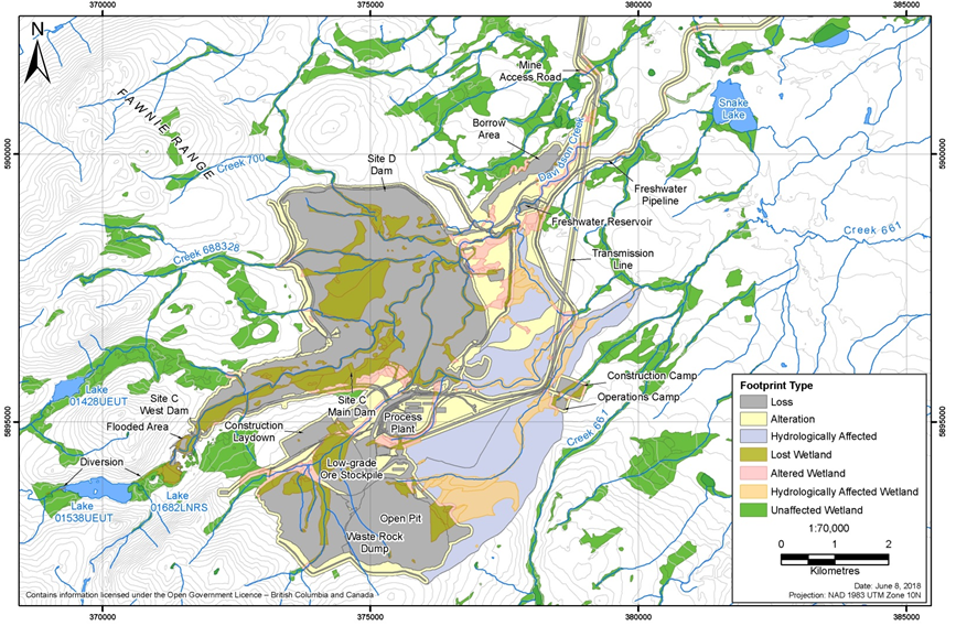
Source: New Gold Inc.
In the EIS, the proponent had originally determined that 30.1 hectares of provincially Blue-listed wetland ecosystems at risk would be lost or altered at the mine site as a result of the Project. However, following a review of ecosystem data, the proponent determined that these wetlands were incorrectly associated with biogeoclimactic zones and updated their assessment to indicate that blue-listed wetlands were not present in the mine site, and would not be affected by the Project.
Hydrological effects to wetlands outside the mine site
Existing hydrological conditions would be altered as a result of the Project, which could in turn alter wetland hydrology beyond the mine site. Changes to groundwater and surface water flows are expected to affect stream flows in Davidson Creek, Creek 661, Creek 705, and Chedakuz Creek to varying degrees during the construction, operation, closure, and post-closure of the Project (see Section 6.1).
The proponent predicted an additional 16.6 hectares of wetlands in Davidson Creek, and 73.1 hectares of wetlands in Creek 661 outside of the mine site would be hydrologically affected, for a total of 89.7 hectares of hydrologically affected wetlands within the local study area.
Proposed mitigation measures, monitoring and follow-up
The proponent committed to implement the following measures to mitigate potential effects to wetlands:
- As part of the Progressive Reclamation Plan, restore or create 305 hectares of swamp and marsh wetlands within the mine site, starting in the operations phase.
- To reduce the magnitude of effects to wetland function between Project construction and the completion of site reclamation, restore or create 42.8 ha of wetlands within the regional study area prior to construction.
- Implement best management practices as described in the proponent's Wetlands Management Plan and relevant guidance documentsFootnote 6 during the construction, operations, and closure phases to mitigate effects to wetland function in remaining wetlands; and prevent further loss of wetland extent including implementing a 30 metre vegetated wetland buffer zone around remaining wetlands at the mine site, maintaining existing drainage patterns during construction through the design and installation of appropriate structures for cross drainage, and maintaining drainage and sediment control infrastructure during all phases.
The proponent anticipated that most of these measures would be effective at a moderate-to-high level in mitigating effects to wetlands. However, the proponent indicated that offsite wetland compensation would have variable effectiveness at replacing wetland functions, depending on the size, type, and location of the particular compensation project.
The proponent proposed a monitoring program to identify potential negative effects to wetland functions from site construction and operations relative to reference wetlands (unaffected wetlands chosen for comparison), and to address effects to wetland functions that may trigger the need for additional mitigating actions to prevent further negative effects. The proponent also committed to implementing an adaptive management program to evaluate the long-term effectiveness of wetlands created or restored as part of wetland compensation and progressive reclamation.
Predicted residual effects to wetlands
Following the implementation of mitigation measures, residual loss and alteration of wetland extent and function are anticipated. While offsite wetland compensation could offset the loss of some wetland functions, to remain conservative in their assessment the proponent considered all wetland loss to be a residual effect.
The proponent characterized residual effects to wetlands due to the Project as moderate in magnitude, local in geographic extent, chronic in duration; and of one-time frequency for wetland loss, and intermittent for wetland alteration. Overall, the proponent predicted that the Project's residual effects on wetlands would be not significant (moderate).
6.2.2 Views expressed
Buffer zone
Environment and Climate Change Canada raised concern about the vegetation clearing and other "light activities" that the proponent stated would be permissible within the 30 metre buffer zone planned for wetlands, because these activities could lead to increased erosion and sediment runoff. The proponent responded that targeted vegetation clearing would include removal of vegetation for safety reasons (e.g. hazard tree removal), clearing to install other mitigation measures (such as sediment and erosion control measures), or creation of temporary access. However, temporary access structures would be avoided in riparian and wetland buffer areas, where possible. The proponent also stated standard operating procedures for working within riparian or wetland buffers would be confirmed during permitting. These procedures will ensure riparian functions are not unduly impaired by Project activities, and that any disturbances will be reclaimed to ensure riparian functions are restored through planting and habitat enhancement, works to restore changes to hydrologic function, or other reclamation practices required to restore riparian functions.
Reference wetlands
Environment and Climate Change Canada requested additional information to determine whether the 12 offsite reference wetlands chosen by the proponent as part of the monitoring program would provide an adequate comparison to wetland functions at the mine site. They also requested that, at a minimum, the proponent identify one additional reference wetland for each of the marsh, swamp, and shallow-water wetland types, and ensure that these wetlands support the same species at risk present in wetlands affected by the project. In response, the proponent indicated that the reference wetlands identified were appropriate, and indicated that the sites chosen are located in a similar geomorphic and biogeoclimatic setting, have similar hydrodynamics, and cover common wetland types. The proponent further indicated that field work would be conducted during permitting, and if species at risk representative of those that would be impacted by the Project are not observed in at least some of the reference wetlands, the proponent will identify alternative reference wetlands where representative species at risk have been observed.
Duration of residual effects
Fisheries and Oceans Canada, Lhoosk'uz Dené Nation, Ulkatcho First Nation, Nadleh Whut'en First Nation, and Stellat'en First Nation raised concern about the proponent classifying the duration of wetland effects in the EIS as long-term instead of permanent, because the bulk of wetland creation would occur in the closure and post-closure phases. Fisheries and Oceans Canada suggested Project effects expected to persist for extended periods of time should be managed and addressed as permanent effects, because they are likely to be of a spatial scale, duration, or intensity that would limit or diminish the ability of fish and other wildlife species to use the habitats to carry out one or more life processes. The proponent responded by updating their characterization of the duration of residual effects from long-term to chronic, and irreversible), stating that wetlands would be considered permanently lost when located within the footprint of project components.
Water quality in created wetlands
Environment and Climate Change Canada raised a concern regarding whether wetlands that would be created onsite around the tailings storage facility and freshwater reservoir areas would be contaminated for a number of years during operations, closure, and post-closure, and whether created wetlands would only meet water quality guidelines during post-closure. If the created wetlands contain poor water quality, this could be harmful to migratory birds and other wildlife. They requested that the proponent provide additional mitigation measures to prevent migratory birds and wildlife from using or frequenting these wetlands until water quality monitoring indicates that migratory birds and wildlife would not be adversely impacted. In response, the proponent stated that water bodies on the mine site would meet the water quality guidelines for wildlife in the B.C. Approved Water Quality Guidelines: Aquatic Life, Wildlife, and Agriculture during post-closure, but that exceedances could occur prior to post-closure in the pit lake and in the tailings storage facility, primarily during the winter months. The proponent indicated that the mine site would be monitored for wildlife, and that actions would be taken to deter migratory birds and amphibians during spring, summer, and fall. The proponent proposed deterrence measures including clearing trees around the tailings storage facility, using holographic tape, using visual and noise deterrents, and the possible use of cannons in frequently used areas.
Wetland compensation
Environment and Climate Change Canada, Nadleh Whut'en First Nation, and Stellat'en First Nation raised a concern that the proponent does not intend to compensate for all wetlands lost. Nadleh Whut'en First Nation and Stellat'en First Nation also raised a concern regarding the proponent's plan to compensate for bog and fen habitat with swamp and marsh habitat. Environment and Climate Change Canada requested that the proponent update the Wetlands Compensation Plan to address effects to wetlands that would fall under federal jurisdiction due to federal permits and authorizations, and subsequently re-evaluate the significance determination for residual effects to those wetlands. The proponent stated that while replacement of one class of wetland with another class does not result in the same suite of functions, swamps and marshes developed for compensation can provide wetland functions with at least similar or greater provision of services when compared to bogs and fens. While some bog and fen wetland restoration is expected as part of offsite wetland compensation, specific amounts of each wetland class that will be created or restored will be determined as part of the final designs. The proponent committed to consult with Indigenous groups on the Wetlands Compensation Plan during permitting.
The proponent is of the view that the proposed wetland compensation is consistent with the Federal Policy on Wetland Conservation. The policy's goal of no net loss of wetland function would apply if wetland loss had reached critical levels, or if the wetlands were ecologically or socio-economically important to the region. The proponent indicated that wetland loss in the local study area would not reach critical levels, nor are the wetlands socio-economically important. The proponent defined ecologically important wetlands as red or blue listed wetlands, which would not be affected by the by project components or activities enabled by federal authorizations.
Lake 01682LNRS enlargement as wetland compensation
Environment and Climate Change Canada expressed concern regarding the proponent's assertion that the enlargement of Lake 01682LNRS (see Figure 5 for location) would constitute wetland compensation. The Lake 01682LNRS enlargement would allow for passive surface water management of the tailings storage facility site C. They were of the view that the enlarged Lake 01682LNRS should be considered a project component, and not be included in the offsetting area for loss of wetlands or fish habitat. In response, the proponent adjusted its offsetting calculations and stated that although the enlargement of Lake 01682LNRS would create 13.1 hectares of marsh and shallow water wetlands, it would result in the loss of 6.9 hectares of existing wetlands. The result would be a net gain would be 6.2 hectares of habitat, which was considered by the proponent to be wetland compensation.
Effects to amphibians from wetland compensation
Environment and Climate Change Canada expressed concern that amphibians, including Western toad, could experience increased predation or competition for resources if fish are introduced in areas that are historically non-fish-bearing. The proponent indicated that while it is possible that fish could be introduced in areas that are historically non-fish-bearing, predation of toads by Rainbow trout, the target species for the offsetting features, is unlikely. Western toads produce an array of toxins that make them unpalatable to most fish species. Other toad species would only be predated by large Rainbow trout. Furthermore, the proponent does not expect competition for resource between toads and Rainbow trout due to differences in diets and feeding patterns. The proponent indicated that they would retain high quality breeding habitat for Western toad at all offsetting or compensation sites, and avoid construction of offsetting or compensation projects during breeding and rearing season.
6.2.3 Agency analysis and conclusion
Analysis of the effects
The Agency is of the view that construction and operations of the project components and activities enabled by federal authorizations would result in the loss of wetland extent, temporary alteration, and hydrological effects to wetlands. These effects to wetlands would negatively affect wetland functions, including loss of wetland habitat for migratory birds and species at risk, and other habitat, hydrological, and biochemical wetland functions.
The Agency is of the view that the proponent should work with Environment and Climate Change Canada to ensure that the mitigation hierarchy for wetland compensation is implemented in a manner that is compatible with the Federal Policy on Wetland Conservation. The mitigation hierarchy prioritizes avoiding the loss of wetlands over minimizing the adverse effects on wetlands, and for minimizing the adverse effects on wetlands over compensating for lost or adversely affected wetlands.
The Agency notes that wetlands created on-site as part of progressive reclamation are not functional during operations due to disturbances from dust, light, and noise. Furthermore, on-site replacement wetlands are compromised by predicted water quality that may not meet applicable water quality guidelines until post-closure. Therefore, there would be a temporal effect to wetland habitat function that will exceed the proponent's threshold for a permanent effect of 35 years. The proponent intends to reduce the temporal effects to wetland function through the creation of 42.8 hectares of offsite wetlands during construction.
The Agency considers the effectiveness of wetlands created or restored during progressive reclamation, or as part of the Wetlands Compensation Plan, to be variable, because the proponent does not intend to compensate for wetland loss at a 2:1 ratio, as recommended in Environment and Climate Change Canada's Operational Framework for Use of Conservation Allowances (2012), nor create the same classes of wetlands as those that are lost in all cases. Due to these uncertainties regarding created or restored wetlands, the Agency considers the loss of wetlands to be chronic in duration, and irreversible.
The Agency is of the view that implementing best management practices identified in the draft Wetlands Compensation Plan, including a buffer around remaining wetlands, would reduce temporary alteration or degradation of wetland functions from remaining wetlands at the mine site. While no mitigation measures have been proposed to specifically mitigate hydrological effects to wetlands outside the mine site, the Agency is of the view that mitigation measures described in Section 6.1 to reduce effects to groundwater and surface water would also reduce hydrological effects to wetlands.
Project components and activities enabled by federal authorizations would affect 14.3 percent of wetlands in the local study area. The Agency concurs that this would result in an effect to wetlands that is moderate in magnitude and local in geographic extent. Concerning frequency, the effect would occur once for wetland losses due to land clearing, and intermittently for temporary alteration of or hydrological effects to remaining wetlands. The Agency considers the duration of effects to wetlands to be long-term for wetland alteration, and chronic and irreversible for wetland loss. Context is moderate due to the sensitive nature of wetland habitats and the use of wetland habitats by several species at risk.
Key mitigation measures
The Agency has considered the mitigation measures proposed by the proponent, advice from expert federal authorities, and comments received from Indigenous groups and the public in identifying the following key mitigation measures to be implemented by the proponent:
- Mitigate the adverse effects to wetlands with a preference for avoiding the loss of wetlands over minimizing the adverse effects on wetlands, and for minimizing the adverse effects on wetlands over compensating for lost or adversely affected wetlands.
- Implement a full suite of best management practices, as identified in the Wetlands Management Plan, including a 30 metre vegetated buffer around mapped wetlands in the mine site that would not be directly affected by mine site infrastructure, and avoid temporary and permanent features within the 30 metre wetland buffer zones.
- In consultation with relevant authorities and Indigenous groups, and in accordance with Canada's Federal Policy on Wetland Conservation and Operational Framework for Use of Conservation Allowances, compensate for wetland functions lost or degraded as a result of project components or activities enabled by federal authorizations prior to the operations phase.
- In consultation with Environment and Climate Change Canada and Indigenous groups, create or restore wetlands at the mine site as part of the progressive reclamation plan to replace wetland functions lost during land clearing.
- Manage surface water and avoid erosion and sedimentation in the areas affected by the Project to ensure that the hydrology of wetlands and water quality are maintained to the extent possible during all Project phases.
Follow-up requirements
The Agency has considered the follow-up and monitoring plans proposed by the proponent, expert advice from federal authorities, and comments received from Indigenous groups in identifying a follow up plan to verify the accuracy of the environmental assessment with respect to effects to wetlands from project components and activities enabled by federal authorizations, and to verify the effectiveness of mitigation measures. The follow-up plan, to be developed in consultation with Indigenous groups and Environment and Climate Change Canada, should include the following:
- Prior to construction, confirm type of wetlands present on the site, including red-listed, blue-listed or other ecologically significant wetlands, to inform the development of the compensation plan. In the event that red-listed, blue-listed or other ecologically significant wetlands are determined to be present, implement additional mitigation measures to the satisfaction of Environment and Climate Change Canada.
- Monitor changes to wetland hydrological, biochemical, and ecological functions that result from wetland loss, alteration, and hydrological effects over the life of the mine.
- Monitor wetlands restored or created offsite as part of the Wetlands Compensation Plan on an annual basis to ensure that individual sites are meeting or exceeding performance standards for wetland function established in consultation with Environment and Climate Change Canada.
- Monitor wetlands created at the mine site as part of the progressive reclamation plan on an annual basis to ensure that individual sites are meeting or exceeding performance standards for wetland function established in consultation with Environment and Climate Change Canada.
Conclusion
Taking into account the implementation of the mitigation measures described above, the Agency is of the view that project components and activities enabled by federal authorizations are unlikely to result in significant adverse environmental effects to wetlands.
6.3 Fish and Fish Habitat
The Project has the potential to affect fish and fish habitat as a result of the construction and operation of mine components including the open pit, tailings storage facility, waste rock dumps, environmental control dam, and seepage, water management infrastructure, and linear components. The Agency focused its assessment on direct mortality, fish health, fish habitat loss and isolation, and changes to fish habitat due to changes in stream flow. The Agency's assessment included the following watercourses where the mine components are located or that would experience downstream effects: Davidson Creek, Creek 661, Creek 705, Chedakuz Creek, Tatelkuz Lake, and their tributaries. The Agency also considered the effects of mitigation and offsetting measures to fish and fish habitat in Davidson Creek and the Creek 705 watershed, including the enlargement of Lake 01682LNRS.
The proponent developed a Fisheries Mitigation and Offsetting Plan to mitigate the effects to fish and fish habitat resulting from the Project. Measures include flow augmentation in Davidson Creek to maintain instream flow needs for fish, enlargement of Lake 01682LNRS in the Davidson Creek watershed and diversion of water to Lake 01538UEUT in the Creek 705 watershed, and several off-site habitat creation and restoration projects. Flow augmentation inputs through the freshwater supply pipeline include water pumped from Tatelkuz Lake, non-contact runoff water diverted around the tailings storage facility, and treated mine contact water. The Agency's assessment considered the effects of flow augmentation and the Lake 01682LNRS enlargement to fish and fish habitat in Davidson Creek and the Creek 705 watershed.
The Agency concludes that the Project is not likely to result in significant adverse environmental effects on fish and fish habitat. The information that supports the Agency's conclusion follows.
6.3.1 Proponent's assessment of environmental effects
The proponent selected two fish indicators, Rainbow trout and Kokanee, because these were the dominant species in the local and regional study areas. Both species use stream and lake habitats, although at different times of the year.
Anticipated effects
Direct mortality
The proponent identified the potential for direct mortality to fish during project construction and decommissioning due to contact with heavy equipment, stranding from dewatering, and blasting. During operations, directly mortality could result from impingement and entrainment in water and wastewater treatment infrastructure.
Changes in fish health
Fish health could be affected through changes in water quality, stream flows, and water temperature, and from exposure to biological contaminants. Changes in water quality and stream flows are described in Section 6.1. The effects of changes in water quality and temperature resulting from the proposed fish habitat offsetting measures are considered in this section.
Potential changes to fish health as a result of predicted changes in water quality and stream flows such as decreased metabolism and growth, reduced mobility that may impair predator evasion, and altered behaviours, including migration and homing, that may diminish reproductive and spawning success.
The effects of the proponent's proposed fish habitat offsetting measure (to enlarge Lake 01682LNRS) on water quality, including the increase of methylmercury levels, were not considered in the Agency's assessment of the aquatic environment (Section 6.1), but were considered in the fish and fish habitat section. The proponent predicted that increased methylmercury concentrations could result in decreased fish growth, reproductive success, and survival.
Flow augmentation in Davidson Creek could result in water temperatures that differ from baseline conditions. Winter water temperatures were predicted to be warmer than baseline, while summer temperatures were predicted to be cooler. Changes in water temperature regime may alter spawning timing, fry emergence timing, and growth rates, resulting in decreased fish population numbers and densities.
The proponent predicted that enlargement of Lake 01682LNRS could increase methyl mercury concentrations that could result in decreased fish growth, reproductive success, and survival. In addition, the creation of a diversion channel connecting Lake 01682LNRS to Lake 01530UEUT (presently two separate watersheds) could result in the transmission of biological contaminants (i.e. pathogens and parasites) between the two watersheds. Biological contaminants have the potential to decrease the health and/or survival of resident fish and reduce the genetic uniqueness of Rainbow trout populations in Lake 01682LNRS and Lake 01538UEUT.
Habitat loss and isolation
The construction and development of mine site components, and riparian habitat clearing associated with linear components, would result in loss of fish habitat in the Davidson Creek and Creek 661 watersheds (Table 7). Habitat availability for critical lifecycle requirements, including spawning, juvenile rearing, adult foraging, and overwintering of resident fish, would be altered.
The construction of several project components would result in the isolation of upstream fish habitat (i.e. obstruction of fish passage) in the Davidson Creek watershed (Table 7). This would alter: productive capacity in the affected streams due to the removal of overwintering habitat; Rainbow trout movement and migration routes; and water, nutrient, and benthic macroinvertebrate drift to lower stream reaches.
The proposed habitat offsetting plan to pump water from Tatelkuz Lake for flow augmentation in Davidson Creek could lower lake levels and result in littoral habitat losses. The proponent indicated the fluctuations in Tatelkuz Lake levels would be within the range of natural variability.
|
Stream name |
Project component(s) |
Habitat effect |
Habitat type |
Area lost |
|---|---|---|---|---|
|
Davidson Creek |
Tailings storage facility, seepage collection infrastructure, environmental control dam, freshwater reservoir, west waste rock dump, low-grade ore stockpile, open pit |
Habitat loss |
Instream |
11 |
|
Riparian |
79 |
|||
|
Tailings storage facility, seepage collection infrastructure, west waste rock dump, low-grade ore stockpile, open pit |
Habitat isolation |
Instream |
12 |
|
|
Riparian |
29 |
|||
|
Creek 661 |
Tailings storage facility, seepage collection infrastructure, plant site, construction and operations camps |
Habitat loss |
Instream |
1.3 |
|
Riparian |
15 |
|||
|
Various |
Transmission line, airstrip access road, freshwater supply system, mine access road |
Habitat loss |
Riparian |
1.7 |
|
Total habitat loss |
108 |
|||
|
Total habitat isolation |
41 |
|||
Changes in fish habitat due to changes in stream flow
Changes in stream flows can affect the availability and quality of fish habitat through the alteration of instream conditions such as water depth and velocity, seasonal timing of flows, and physical habitat structure (e.g. sediment grain size and woody debris), and riparian habitat. This could affect Kokanee using Davidson Creek, Creek 661, and Chedakuz Creek for spawning and incubation, and Rainbow trout using Davidson Creek, Creek 661, Creek 705, and Chedakuz Creek for spawning and fry and juvenile rearing.
Proposed mitigation measures, monitoring and follow-up
The proponent committed to implement the following measures to mitigate potential effects to fish and fish habitat:
- Avoidance and minimization of instream works; where avoidance is not possible, fish salvage and isolation of mine site streams, adherence to reduced risk timing window, and follow Fisheries and Oceans Canada's Guidelines for the Use of Explosives in or near Canadian Fisheries Waters (1998).
- Use existing stream crossings where possible and temporary single-span bridge installation, or open-bottom culverts, where appropriate.
- Use intake screens required by Fisheries and Oceans Canada, and design outlet pipes to prevent fish entry into the freshwater supply system and water treatment plants.
- Capture seepage from the open pit, tailings storage facility, west waste rock dump, low-grade stockpile, freshwater reservoir, environmental control dam, diversion ditches, seepage collection trench, construction and operations camps, and plant site through the construction of perimeter ditches, two seepage interception trenches at Davidson Creek, and the pit lake seepage collection system.
- Active water treatment of seepage and contact water in water treatment plants.
- Emergency spill response, machinery maintenance, and appropriate fuel storage and refueling at the mine site, mine access road, airstrip, freshwater supply system and water treatment plants, and Kluskus Forest Service Road upgrades.
- Erosion and sediment control at the mine site, mine access road, airstrip, freshwater supply system and water treatment plants, Kluskus Forest Service Road upgrades, and transmission line.
- Strip vegetation and topsoil from Lake 01682LNRS and the diversion channel where appropriate to reduce mercury mobilization.
- Create, enhance, and rehabilitate fish habitat as described in the Fisheries Mitigation and Offsetting Plan. Where no mitigation is possible, construct replacement habitat in Davidson Creek and other watersheds.
- Augment flows in Davidson Creek with the freshwater supply system.
- Locate Tatelkuz Lake freshwater supply system intake at a depth that will produce temperatures appropriate for Davidson Creek.
- Diversion of non-contact water upstream of the open pit and the tailings storage facility, with release into Davidson Creek downstream of the environmental control dam.
- Reuse water from water treatment plants for mining operations to reduce water withdrawal from Tatelkuz Lake and associated flow reduction in Chedakuz Creek.
- Monitor fish and fish habitat through the development of an Aquatic Effects Monitoring Plan and effects related to intra-basin transfer.
Anticipated residual effects
After the implementation of mitigation measures, the proponent predicted residual effects on fish and fish habitat from direct mortality, changes in fish health, habitat loss and isolation, and changes in habitat due to changes in stream flows as result of mine site activities, including the freshwater supply system. The proponent did not anticipate residual effects to fish or fish habitat from the linear components.
Direct mortality
The proponent characterized the effects to direct mortality of fish as negligible in magnitude because the implementation of mitigation measures and adherence to Best Management Practices would reduce fish mortality. The proponent concluded that overall, loss of fish would be not significant (minor).
Changes in health
As described in Section 6.1, the proponent predicted that, although several contaminants of concern in Davidson Creek and Creek 661 would exceed B.C. Water Quality Guidelines for the Protection of Aquatic Life following the discharge of treated mine contact water, no parameters exceeded the acute water quality guideline for aquatic life. The proponent therefore characterized the effects to fish health from changes in water quality as being moderate in magnitude. The proponent concluded that residual effects to fish due to changes in water quality in Davidson Creek, Creek 661, and Chedakuz Creek would be not significant (moderate).
The proponent indicated that the chemical migratory cues for fish could be altered in Davidson Creek as a result of water supplied by the freshwater supply system. The magnitude was characterized as moderate because a temporary decrease in the number of fish spawning in Davidson Creek could result in an overall decrease in population levels. However, the proponent anticipated that they would adapt to the changed chemical environment within one generation, resulting in a not significant (moderate) effect.
The predicted changes in water temperature in Davidson Creek are unlikely to result in any detectable adverse effect on fish populations, and the temperatures would be within the natural variation of the creek, resulting in a low magnitude effect. The overall residual effect was characterized as not significant (minor).
In terms of mercury mobilization in Lake 01682LNRS as a result of the lake enlargement, the proponent characterized the magnitude as low because vegetation and soils would be removed prior to flooding. Although fish tissue mercury levels would be expected to increase, concentrations were not expected to exceed thresholds that could affect growth, survival, or reproduction in Rainbow trout. The overall effect was therefore predicted to be not significant (minor).
Habitat loss and isolation
The proponent characterized the effects to fish habitat loss and isolation as negligible in magnitude because there would be no detectable changes from baseline following the implementation of the Fisheries Mitigation and Offsetting Plan. The proponent proposed 76.6 hectares of instream habitat and 47.8 hectares of riparian habitat gains through offsetting measures. The proponent concluded that overall, loss of fish habitat on the mine site would be not significant (minor).
Through the application of mine site water reuse and active water treatment, the volume of water required from Tatelkuz Lake to maintain instream flow needs for fish in Davidson Creek would decrease. The magnitude of the effect to littoral habitat loss in Tatelkuz Lake was characterized as negligible because the change in habitat was predicted to be within the range of natural variation. The overall effect was characterized as not significant (negligible)
Change in stream habitat due to changes in stream flow
Following the implementation of the freshwater supply system to maintain instream flows needs for fish, no Kokanee or Rainbow trout habitat losses were predicted to exceed 10 percent in any of the mine site streams, with the exception of Kokanee spawning habitat in Davidson Creek where habitat losses were predicted to be 13 percent during post-closure. The proponent established a threshold for acceptable change for fish habitat of 10 percent, and therefore the Kokanee spawning habitat losses resulted in a moderate magnitude. The effect would be continuous in frequency and chronic in duration in all streams, and irreversible in Creek 661 and Creek 705. The proponent characterized the residual effect of changes in stream habitat due to changes in stream flow as not significant (moderate) for Davidson Creek, Creek 661, Chedakuz Creek, and Creek 705.
The flow regime developed to mitigate changes to stream flow in Davidson Creek includes overwintering habitat flow requirements and flushing flows to remove fine sediments from spawning gravels. Consequently the proponent did not anticipate effects to fish overwintering habitats or sediment transport.
6.3.2 Views expressed
Selection of indicator species
Lhoosk'uz Dené Nation and Ulkatcho First Nation raised concern as to whether Rainbow trout and Kokanee are sufficient indicators for the "fish" valued component, and whether these species would be representative of smaller fish species with different life histories and habitats, such as Burbot. The proponent stated that Rainbow trout and Kokanee were selected as indicator species because these species were identified as important by Indigenous groups, they are the most common species with the widest spatial distribution in the assessment area, and they are represented in all of the broad habitat types. Rainbow trout and Kokanee have sufficiently different diets, habitat preferences, and seasonal life history timing that any potential effect of the Project on fish and fish habitat in streams and lakes would affect one or both species. The proponent recognized that certain fish in the assessment area have unique characteristics, and therefore potential project effects for specific species were also considered.
Fish habitat baseline
Lhoosk'uz Dené Nation and Ulkatcho First Nation questioned whether the fish and fish habitat baseline information adequately describes the variability within and among resources, processes, and interactions. Lhoosk'uz Dené Nation and Ulkatcho First Nation questioned whether periphyton and benthic invertebrate sampling was adequate. The proponent responded by indicating that periphyton and benthic invertebrate sample collection followed standardized protocols as described in B.C.'s Ministry of Environment and Climate Change Strategy's guidance, and that sampling locations were selected based on the potential for effects due to the Project. The proponent indicated that the Aquatic Effects Monitoring Plan would include analysis and methodologies that are agreed upon by Indigenous groups and relevant authorities to detect mine-related effects in the aquatic environment, and would be updated as necessary to ensure that data collection and analysis is adequate.
Water treatment
Environment and Climate Change Canada raised concerns over uncertainty associated with water quality predictions, seepage rates, and the long-term requirements for water treatment. They requested additional information on the assessment of residual effects to fish and fish habitat from changes in water quality including the uncertainty of base case predictions, sensitivity scenarios, and associated changes to the significance characterization. They also sought additional detail regarding the feasibility of increasing the water treatment capacity, and other measures to mitigate residual effects, benchmarks, and parameters that will be monitored for water quality. The proponent carried out additional sensitivity analyses with associated uncertainty to assess the change in the receiving environment relative to baseline and to identify key areas for monitoring and contingency planning. Regular seepage monitoring through all project phases will allow for early detection of underestimates of seepage rates or contaminant concentrations. The design of the water treatment infrastructure is modular allowing flexibility to implement contingencies and increase capacity should monitoring show predictions in seepage quantity and quality are not being met.
Risk of disease, genetic mixing between Rainbow trout populations
Fisheries and Oceans Canada conducted a detailed assessment of the effects on fish and fish habitat of intra-basin transfer between the Davidson Creek watershed and the Creek 705 (Fawnie) watershed due to the enlargement and diversion of Lake 01682LNRSFootnote 7. They indicated that the diversion creates potential risks to aquatic species, including increased flows, habitat conversion, introduction of disease, and genetic mixing between genetically unique Rainbow trout populations. The proponent responded by providing the results of a genetic study performed on Rainbow trout in the two watersheds showing genetic similarity between the populations, and the opinion of a genetic expert indicating the two watersheds may become naturally connected in exceptionally high water years.
Riparian habitat loss
Fisheries and Oceans Canada expressed concern regarding whether effects to riparian fish habitat had been fully considered, and suggested that a total permanent loss of the riparian area alongside streams had not been accounted for in the proposed Fisheries Mitigation and Offsetting Plan. In response, the proponent indicated that riparian area was calculated for the purposes of assessing effects to the terrestrial ecosystem, which differs from the assessment of effects to fish habitat. The proponent updated the fish habitat offsetting plan to include riparian habitat along affected streams and lakes in the Project area. Riparian buffers were applied to the affected stream lengths, with the size of the buffer dependent on the presence of fish species in the adjacent stream. Losses calculated as part of this updated accounting include 1.7 hectares of riparian habitat along linear corridors (roads, transmission lines) and 125 hectares of riparian habitat at or upstream of the mine site.
Tatelkuz Lake
Fisheries and Oceans Canada expressed a number of concerns about the drawdown of water from Tatelkuz Lake to augment the flow in Davidson Creek, including whether the predicted maximum lake level drawdown of 11 centimetres represents the full impacts to the lake under dry conditions. They questioned whether water from Tatelkuz Lake would provide flushing flows and supplemental water needs for the tailings storage facility during dry years, while still providing gravel recruitment during normal flow years. The proponent responded by indicating that an 11 centimetre drawdown would be for 1 in 50 year dry conditions. The proponent proposed no flushing flows in years drier than a 1 in 50 year return period. If this situation occurs during the lifetime of the Project, the freshwater supply system would provide water at a rate consistent with juvenile Rainbow trout overwintering life cycle requirements and then transition directly to the higher spring spawning flow. The augmented flow regime has been designed to provide gravel cleaning flows, but will avoid flows high enough to cause loss of gravels through scour and downstream transport.
Lhoosk'uz Dené Nation and Ulkatcho First Nation raised questions about the adequacy of the proponent's assessment of the potential loss of fish habitat in Tatelkuz Lake. The proponent indicated that fish and fish habitat in Tatelkuz Lake were studied in 2011, 2012, and 2013, and that the information provided in the EIS is sufficient for an environmental effects determination. The proponent indicated that Tatelkuz Lake has a steep littoral zone, and that this zone makes up only 11 percent of the lake area. The proponent indicated that gravel-dominated habitat would be reduced by less than 10 percent compared to baseline conditions during all seasons in an average year, including the shallow-sloped littoral zones and sand/gravel peninsulas that were assessed and mapped in the baseline surveys. The proponent committed to conduct fish habitat studies on the northwest and southeast shallow-sloped habitat of the lake, and monitoring fish habitat quantity and quality in the Tatelkuz Lake littoral zone in mid-summer, prior to the commissioning of the freshwater supply system. The proponent also committed to consult Ulkatcho First Nation and Lhoosk'uz Dene Nation on the draft Aquatic Effects Monitoring Plan, which would reference these studies.
Fisheries and Oceans Canada, Lhoosk'uz Dene Nation, Ulkatcho First Nation, and the Carrier Sekani First Nations expressed concerns regarding the uncertainty associated with flow augmentation mitigation and the freshwater supply system, including the risk of flow regime changes, water temperature changes, water quality changes, genetic mixing of Rainbow trout populations, and water composition changes which may alter spawning migratory cues, escapement, and success. The Indigenous groups raised concern that water quality guidelines established by Indigenous groups for the protection of aquatic life had not been used in the modelling results tables for receiving environment stations. They requested a detailed effects analysis of these changes on algae and invertebrates compared to all baseline variables in Davidson Creek, with water quality exceedances highlighted, and proposed site-specific guidelines. The proponent responded to these concerns by providing an updated water quality effects assessment. Fisheries and Oceans Canada requested that the proponent more clearly describe mitigation measures, follow-up, and contingency plans to address these uncertainties. They recommended that follow-up and monitoring plans be developed. In response to concerns regarding changes to water temperature, the proponent conducted additional modelling that incorporated updated water management plans, which demonstrated that the alteration of water temperatures for Rainbow trout and Kokanee would be within the range of natural variability.
Fish habitat offsetting
Indigenous groups, Fisheries and Oceans Canada, and B.C.'s Ministry of Forests, Lands, and Natural Resource Operations and Rural Development raised concerns with the proponent's proposal to rehabilitate orphaned culverts as a key component of its Fisheries Mitigation and Offsetting Plan. The proponent continued to assess the potential for including culvert replacement in its plan, however, it ultimately determined that none of the identified culverts were barriers to fish passage and thus did not qualify.
Fisheries and Oceans Canada raised concern regarding the proponent's proposal to consider the enlargement of Lake 01682LNRS as fish habitat offsetting, instead of as a component of the Project. They indicated that the Lake 01682LNRS enlargement could be considered design mitigation, but would not be considered offsetting. They also indicated that adding habitat features would be considered offsetting, as would the connecting channel between Lakes 01682LNRS and Lake 01538UEUT.
Increased flow in to Creek 705
Environment and Climate Change Canada expressed concern about the anticipated impacts of increased flow to lakes and streams in the Creek 705 watershed due to the diversion of water from the upper Davidson Creek watershed. They requested additional information about the pond that is proposed to create a hydraulic barrier and establish a fresh water seepage gradient towards the tailings storage facility site C pond, and about the proposed mitigation measures to prevent and control seepage and runoff into fish-bearing waters. In response, the proponent provided technical information on a proposed pond upstream of tailings storage facility site C Pond that would create a hydraulic barrier between tailings storage facility site C Pond and Creek 705. The proponent stated that based on hydraulic modelling in middle and lower reaches of Creek 705, any flow changes in upper Creek 705 are not expected to result in adverse effects to fish habitat. The proponent's assessment concluded that a negligible (less than 5 percent) change in fish habitat availability from baseline would occur. The proponent noted that some of the changes would be increases in habitat availability, having a positive effect on certain life history stages.
6.3.3 Agency analysis and conclusion
Analysis of effects
Direct mortality
The Agency is of the view that despite the proponent's avoidance and mitigation measures, which would reduce fish mortality, there will be unavoidable direct mortality of fish in Davidson Creek and Creek 661, and their tributaries and in Tatelkuz Lake during construction. Considering the mitigation measures proposed to reduce the direct mortality of fish, the Agency is of the view that the magnitude of the effect is low, and of local geographic extent, because the effects would be limited to upper Davidson Creek, the headwaters of Creek 661, and Tatelkuz Lake in the local study area. The effects would be chronic and irreversible and of low context.
Changes in fish health
Although fish health could be affected through changes in water quality, the Agency is of the view that the proposed measures to address water quality and water management concerns will also help mitigate effect to fish health. Water quality and fish monitoring will verify that fish populations at the mine site remain healthy and will be required long-term because requirements for water treatment extend into the post-closure phase, or possibly indefinitely.
Although the proponent has demonstrated that water chemistry is very similar between Davidson Creek and Tatelkuz Lake, uncertainty remains as to whether fish homing in Davidson Creek would be affected by the Project due to the changes in the olfactory environment. The proponent would rely on groundwater as a water source to maintain the olfactory environment in Davidson Creek; however, it has also stated that groundwater will be significantly reduced in the creek with the construction of the seepage interception trench, with the annual average decreasing from baseline by 60 to 65 percent, depending on project phase at sites closest to the tailings storage facility. Decreased groundwater input would be made up with inputs from the freshwater supply system. The Agency agrees with the proponent that the magnitude is moderate because fish spawning in Davidson Creek may be temporarily affected, resulting in decreased population levels. The effect is localized to Davidson Creek, would occur intermittently as inputs from the freshwater supply system will vary over the life of the Project and therefore have differing water chemistry, and be chronic as the effect would last into post-closure as components of the freshwater supply system are decommissioned. The effect would be reversible in the long-term because in post-closure, water inputs and the olfactory environment in Davidson Creek would be expected to remain relatively constant for the Rainbow trout and Kokanee populations spawning there. Context would be moderate as fish have been exposed to naturally high level of several metals in Davidson Creek and Creek 661.
With regards to the potential effects of temperature change due to flow augmentation in Davidson Creek, the Agency agrees with the proponent's view that according to updated temperature modelling, the temperatures in Davidson Creek will meet the life history requirements for fish. Although there will be minor deviations from baseline, typically in the range of 1 to 1.5 degrees Celsius from baseline temperatures, these changes are typically within the range of natural temperature variation in Davidson Creek, resulting in a low magnitude effect. The effect is localized in geographic extent to Davidson Creek, would occur with continuous frequency throughout the life of the Project, be chronic in duration because the effect will last into post-closure, and will be irreversible as temperature changes will last into post-closure. The context would be low. The water management design has flexibility which will allow the proponent to manage temperatures in Davidson Creek should monitoring indicate effects to fish productivity due to temperature changes.
The Agency agrees with the proponent's assessment that residual effects on Rainbow trout are likely to occur due to increases in mercury concentrations due to the Lake 01682LNRS enlargement. This effect would be of low magnitude, local extent, long-term duration, continuous frequency, and reversible because mercury concentrations are expected to return to baseline conditions after approximately 30 years. The context is moderate due to the presence of a provincially-listed species in Lake 01682LNRS.
The Agency recognizes that the diversion of Lake 01682LNRS to Lake 01538UEUT will likely be subject to Fisheries and Oceans Canada intra-basin licensing, and agrees with the proponent that adverse effects from the diversion are unlikely. The Agency and Fisheries and Oceans Canada are satisfied with the genetic studies conducted by the proponent that demonstrated that the Rainbow trout populations in the Davidson Creek and Creek 705 watersheds are closely related and, although the populations are distinct, the minor reduction in biodiversity resulting from the expected hybridization of these populations would be reasonable. The relatedness of the Rainbow trout populations in the two watersheds indicates that the pathogen community is likely also similar. The proponent has committed to conducting a parasite and pathogen inventory and comparison between Lake 01682LNRS and Lake 01538UEUT, to be completed prior to the diversion of the watersheds.
Habitat loss and isolation
The Agency is of the view that loss and isolation of fish and fish habitat would occur in the Davidson Creek and Creek 661 watersheds as a result of the construction of project components. Fish habitat under the mine footprint and upstream of it will be permanently lost or isolated through post-closure. The Agency acknowledges that the adverse effects to fish habitat would be offset following the implementation of the Fisheries Mitigation and Offsetting Plan. Considering the mitigation measures proposed to reduce habitat loss and isolation, the Agency is of the view that the magnitude of the effect is low and would be of local geographic extent because the effects would be limited to upper Davidson Creek and the headwaters of Creek 661 in the local study area. Habitat losses will be chronic in duration, continuous in frequency, irreversible, and of low context.
The Agency agrees with the proponent's assessment regarding littoral habitat reduction in Tatelkuz Lake associated with water pumped for flow augmentation in Davidson Creek. The Agency acknowledges that the proponent has modified the original Mine Water Management Plan for the fresh water supply system to minimize the amount of water required from Tatelkuz Lake. The implementation of an Aquatic Effects Monitoring Plan developed in consultation with Indigenous groups should include littoral habitat monitoring of Tatelkuz Lake to verify that the predicted lake level decreases are within the range of natural variability. The Agency agrees that the magnitude is low as the predicted fluctuations in the water levels in Tatelkuz Lake are within the range of natural variability observed in these habitats. The effect is site-specific because it would be localized to Tatelkuz Lake, continuous in frequency, and long-term duration because it would last into closure as components of the freshwater supply system are decommissioned. The effect would be reversible in the long-term (post-closure) as water withdrawals from Tatelkuz Lake will be discontinued at decommissioning. The context is moderate due to the presence of a provincially-listed species in Tatelkuz Lake.
Change in stream habitat due to changes in stream flow
The Agency is of the view that flow augmentation through the freshwater supply system, and inputs from non-contact water diversions and treated mine contact water, will provide sufficient flows to meet instream flow needs and limit reductions in habitat availability for Rainbow trout and Kokanee in Davidson Creek and Chedakuz Creek. Permanent losses of fish habitat due to changes in stream flow would be offset through the implementation of the Fisheries Mitigation and Offsetting Plan. The Agency agrees with Fisheries and Oceans Canada that there is some uncertainty associated with how fish will respond to flow changes in Davidson Creek and Chedakuz Creek and that a follow-up program would be required to validate model predictions and to determine adverse effects during post-closure. Based on these considerations, the magnitude of the residual effects to fish and fish habitat from changes in stream flows from project-related activities is expected to be moderate because during some project phases, flow reductions in Davidson Creek may result in habitat availability changes that exceed 10 percent, especially during winter months under dry conditions. The residual effect would be local in extent, continuous in frequency, and chronic in duration because the effect will last to post-closure, at which point the effect would be reversible in Davidson and Chedakuz Creeks. The context would be low. Habitat losses due to changes in flow would be continuous in frequency, chronic in duration, and irreversible in Creek 661. Fish habitat losses in Creek 661 would be offset through the implementation of the Fisheries Mitigation and Offsetting Plan. For Creek 705, changes in stream flow would be negligible but the effect would be irreversible because of the permanent diversion of Lake 01682LNRS into the Creek 705 watershed. The Agency is of the view that effects to fish habitat availability would be negligible.
Key mitigation measures
The Agency has considered the mitigation measures proposed by the proponent, advice from expert federal authorities, and comments received from Indigenous groups and the public in identifying the following key mitigation measures to be implemented by the proponent:
- Implement measures to protect fish and fish habitat when undertaking activities in or near water, including fish salvage; adhering to reduced-risk timing windows; and avoidance and minimization, of in-stream works, consistent with Fisheries and Oceans Canada guidance and in consultation with Fisheries and Oceans Canada.
- Use intake screens required by Fisheries and Oceans Canada and design outlet pipes to prevent fish entry for the freshwater supply system.
- Collect and treat mine seepage and contact surface water to meet parameter concentrations outlined in the Metal and Diamond Mining Effluent Regulations and to meet the pollution preventing requirements of the Fisheries Act prior to discharge into the receiving environment.
- Implement an offsetting plan for any adverse effects to fish and fish habitat caused by the Project and for any habitat losses related to mine tailings and waste disposal, pursuant to the Fisheries Act, and Schedule 2 of the Metal and Diamond Mining Effluent Regulations. Ensure any riparian habitat losses as a result of construction of mine site and linear components are accounted for in the offsetting plan. These plans would be developed with Fisheries and Oceans Canada and with Environment and Climate Change Canada, and through engagement with Indigenous groups.
- Implement a freshwater supply system that pumps water from Tatelkuz Lake to the freshwater reservoir in the Davidson Creek valley to maintain flows in Davidson Creek in operations, closure and post-closure at the rates outlined by month in Tables 16 and 17 in Appendix 5.1.2.6D of the EIS, within 10 percent. Ensure the flow regime is sourced from inputs to match Davidson Creek temperatures, as described in Appendix C-1 of the Assessments of Effects Related to Project Changes (ERM 2016) document, to the extent possible.Footnote 8
- Limit water withdrawals from Tatelkuz Lake by recycling mine water through water treatment plants, and sourcing water to meet instream flow needs for the northern and southern diversions and the water treatment plants.
- Connect Lake 01682LNRS to Lake 01538UEUT in the Creek 705 watershed prior to the construction of the site C dam to protect the population of Rainbow trout upstream of the Project footprint and to provide downstream connectivity. The construction of the diversion and site C west dam will be in stages to ensure that no fish are lost due to stranding during the construction.
Follow-up requirements
The Agency has considered the follow-up and monitoring plans proposed by the proponent, advice from federal authorities, and comments received from Indigenous groups and the public in identifying the following follow-up programs necessary to verify the predictions of the EA and the effectiveness of mitigation measures:
- Develop and implement a follow-up program, to the satisfaction of Fisheries and Oceans Canada, for Rainbow trout and Kokanee in Davidson Creek, to be initiated five years after flow changes have been instituted and stabilized, to confirm there is low impact on absolute abundance and genetic structure/diversity of Rainbow trout and Kokanee populations.
- Conduct a parasite and pathogen inventory and comparison study in Lake 01538UEUT and Lake 01682LNRS, to be completed prior to the diversion between the Davidson Creek and Creek 705 watersheds.
- Monitor stream temperatures and fish populations in Davidson Creek to ensure that the flow augmentation regime is providing the required habitat as seasonally appropriate for Rainbow trout and Kokanee.
- Develop and implement, in consultation with Indigenous groups, an Aquatic Effects Monitoring Plan which would include studies to monitor fish habitat quantity and quality in the Tatelkuz Lake littoral zone.
- Monitor Rainbow trout and Kokanee populations to reduce uncertainty related to the changes in groundwater input to Davidson Creek and the effect this might have on Kokanee emergence and Rainbow trout juvenile overwintering.
- Monitor Rainbow trout and Kokanee spawner populations in Davidson Creek through surrogate monitoring metrics, including size at 50 percent maturity, red counts, and spawner distribution, to verify no population level effects are occurring as a result of the disruption of homing.
Conclusion
Taking into account the implementation of the mitigation measures, the Agency concludes that the Project is not likely to cause significant adverse environmental effects to fish and fish habitat.
6.4 Migratory Birds
The Agency considered habitat loss and alteration, mortality risk, changes in bird health, and changes in population dynamics in its assessment of migratory birds.
The Agency concludes that the Project is not likely to result in significant adverse environmental effects to migratory birds. The information that supports the Agency's conclusion follows.
6.4.1 Proponent's assessment of environmental effects
Anticipated effects
The proponent selected indicator species for water birds (Ring-necked duck, Yellow rail, Wilson's snipe, and Greater yellowlegs) and forest and grassland birds (Olive-sided flycatcher and interior forest birds). The Yellow rail is listed as Special Concern and the Olive-sided flycatcher is listed as Threatened under Schedule 1 of the Species at Risk Act. In addition to these indicator species, baseline surveys were carried out for five additional migratory birds listed as Threatened (Common nighthawk, Barn swallow and Bank swallow) or Special Concern (Horned grebe and Long-billed curlew) under Schedule 1 of Species at Risk Act and one migratory bird listed as Endangered (Black swift) by the Committee on the Status of Endangered Wildlife in Canada. All of the indicator species and three of the species at risk (Common nighthawk, Barn swallow and Black swift) were detected during the baseline surveys. Potential effects to non-migratory birds listed under the Species at Risk Act are discussed in Section 6.5.
The construction and operation of the mine site, access roads, airstrip, freshwater supply system, and transmission line would result in the loss and alteration of migratory bird habitat in the local study area. The proponent modelled habitat loss and alteration in moderate to high-value habitat within the local study area and regional study area. Habitat suitability models were not field verified for migratory birds.
Moderate to high-value habitats for water birds include low elevation ponds, lakes and wetlands. The predicted extent of habitat loss and alteration is presented in Table 8.
|
Species |
Habitat lost or altered (ha) |
Local study area |
Regional study area |
||
|---|---|---|---|---|---|
|
Total habitat (ha) |
Habitat lost or altered (% of local study area) |
Total habitat (ha) |
Habitat lost or altered (% of regional study area) |
||
|
Ring-necked duck |
27 |
306 |
9 |
11 380 |
<1 |
|
Yellow rail |
25 |
207 |
12 |
3 635 |
<1 |
|
Wilson's snipe |
572 |
2 700 |
21 |
29 949 |
2 |
|
Greater yellowlegs |
2 019 |
5 254 |
38 |
51 015 |
4 |
Moderate to high-value habitats for forest and grassland birds include old growth conifer forests, and mature forests adjacent to open habitats such as burns, clearcuts, and meadows. The predicted extent of habitat loss and alteration is presented in Table 9. For Olive-sided flycatcher, the proponent predicted overall habitat losses, but stated that vegetation clearing for the Project would be beneficial to the species through the creation of additional forage areas.
|
Species |
Habitat lost or altered (ha) |
Local study area |
Regional study area |
||
|---|---|---|---|---|---|
|
Total habitat (ha) |
Habitat lost or altered (% of local study area) |
Total habitat (ha) |
Habitat lost or altered (% of regional study area) |
||
|
Olive-sided flycatcher |
2 735 |
10 633 |
26 |
128 685 |
2 |
|
Interior forest birds |
1 264 |
5 312 |
24 |
97 103 |
1 |
Mortality risk for water birds could increase through collisions with aircraft, vehicles, or the transmission line, and increased hunter access. For forest and grassland birds, vegetation clearing and collisions with vehicles were predicted to increase mortality risk.
The Project could affect bird health as a result of increased contaminants in water, sediment, and soil. Water bird health may be affected during all phases of the Project through contact with contaminants in the tailings storage facility, the pit lake (post-closure only), and water downstream of the mine site. Forest and grassland bird health may be affected during construction when soil is disturbed, and during operations when dust is generated by transportation associated with the Project.
Migratory bird habitat within the regional study area is extensively fragmented from logging, forest fires, and Mountain pine beetle. The proponent stated that loss of habitat availability from the Project and changes to prey abundance could change predator-prey relationships among some species and contribute to cumulative effects to bird population dynamics.
Proposed mitigation measures, monitoring and follow-up
The proponent committed to implement the following measures to mitigate potential effects to migratory birds:
- Use pre-existing roads and cleared areas to avoid new disturbance.
- Place the transmission line alignment away from wetland and riparian areas or, where wetlands cannot be avoided, locate structures so that the transmission line spans wetlands.
- Minimize degradation and loss of riparian habitat adjacent to mine components with demarcated no-work and management work zones in accordance with B.C.'s Ministry of Forest, Lands, Natural Resource Operations and Rural Development's best management practices.
- Avoid vegetation clearing during bird breeding windows, and undertake pre-construction surveys as per Environment and Climate Change Canada avoidance guidelines.Footnote 9
- Use line markers on the transmission line and phase conductors on distribution lines to prevent collisions
- Post and enforce speed limits along proponent-controlled roads.
- Implement no hunting and no firearms policies (as part of the Wildlife Management Plan).
- Minimize noise and other disturbances during sensitive times for wildlife, particularly for birds during the breeding season.
- Where possible, retain and enhance forest edge habitat along road areas to provide escape or thermal cover for birds.
- Where possible and safe from becoming a fire hazard, retain and enhance coarse woody debris and brush pilings on forest floors for birds nesting in core forest habitats.
- Restore disturbed habitats at mine closure, using native vegetation whenever possible or appropriate.
- Monitor water quality in the tailings storage facility, pit lake (post-closure), and downstream of the Project, and apply measures to deter birds if water quality exceeds B.C. Water Quality Guidelines for the Protection of Wildlife.
- Monitor and investigate bird mortality annually during spring migration, breeding, and fall migration; and implement adaptive management measures to reduce further mortality.
Anticipated residual effects
After the implementation of proposed mitigation measures, the proponent predicted residual effects on migratory birds from habitat loss and alteration, water bird mortality risk, and changes in water bird population dynamics. The proponent did not anticipate residual effects to migratory birds from mortality risk to forest and grassland birds, changes in forest and grassland bird population dynamics, or changes in migratory bird health.
The proponent characterized the effects from migratory bird habitat loss and alteration as low in magnitude and local in geographic extent. The proponent concluded that the loss and alteration of migratory bird habitat would be not significant (minor) for all species.
The proponent indicated that mortality risk would be reduced with the implementation of a no hunting and firearms policy, and through the use of line markers on the transmission line, and characterized the effect as negligible in magnitude, site-specific in geographic extent, and intermittent in frequency. The proponent concluded that the effect to water bird mortality would be not significant (negligible).
The proponent described that water bird population dynamics could change through increased access for predators as a result of construction and clearing, and the introduction of competitors for resources. The residual effect to water birds was characterized as negligible in magnitude, site-specific in geographic extent, and intermittent in frequency. Minimizing sensory disturbance, and early compensation and restoration works, would mitigate changes to water bird population dynamics. The proponent concluded that the residual effect would be not significant (negligible).
6.4.2 Views expressed
Selection of indicator species
Environment and Climate Change Canada, Lhoosk'uz Dené Nation, and Ulkatcho First Nation expressed concern about the suitability of Olive-sided flycatcher as an indicator for forest and grassland bird species that favour interior forest habitat because of the habitat preferences of the Olive-sided flycatcher for edges of natural forest openings and clear-cuts, snags, and tall trees for nesting. They requested an assessment of effects on species with a preference for interior forest habitat. Environment and Climate Change Canada requested an assessment of effects for each bird species at risk which is known to be in the area. Lhoosk'uz Dené Nation, Ulkatcho First Nation, and Saik'uz First Nation also suggested that Greater yellowlegs and Wilson's snipe be added to the assessment for water birds, and that additional species of forest and grasslands birds be assessed.
The proponent provided additional assessments of Greater yellowlegs and Wilson's snipe as representative of water birds, and an assessment for interior forest birds. The assessment for water birds indicated that, due to widespread suitable habitat within the regional study area, and a proportionately small effect of the Project on that area, residual effects to water birds would remain not significant (minor), with high confidence. The assessment for interior forest birds concluded that there would be a 2 percent reduction in the area of suitable habitat within the regional study area that is reversible in the long-term and unlikely to have a significant effect on forest and grassland birds. The proponent noted that modelling for Olive-sided flycatcher followed the B.C. Resources Information Standards Committee's standard approach for forest and grassland birds.
Effects of linear components
Environment and Climate Change Canada commented that the delineation of the local and regional study areas did not appear to consider the impacts of forest fragmentation and edge effects, and requested more information regarding the progressive reclamation methodology for forest habitat along road areas, and how the proponent would determine reclamation success. They also requested further information regarding potential bird collisions with the transmission line, including further details on monitoring to reduce this mortality risk. Nadleh Whut'en First Nation and Stellat'en First Nation expressed concerns regarding edge effects, predation, and follow-up monitoring of reclamation along linear components of the Project (e.g. roads and the transmission line).
The proponent noted that the Project area has already been subject to extensive fragmentation, and stated that the spatial boundary for the local study area was designed to include the area within which potential effects from the Project may occur. The proponent also proposed a new alignment of the transmission line, and an effects assessment that considered mortality risk to wildlife, including birds, due to fragmentation. The proponent concluded that the proposed new alignment of the transmission line would decrease the potential for wildlife mortality, relative to the previous transmission line alignment, from vehicle strikes, hunting, and poaching because the proposed new alignment would disturb less habitat. For this reason, the proponent considered the proposed new alignment of the transmission line to be effective mitigation for wildlife mortality risk, and did not assess the risk of wildlife mortality further. The proponent did, however, commit to establishing markers on the transmission line to reduce the risk of migratory bird collision, and to monitoring and adaptive management. The proponent noted its commitment to restore and develop disturbed habitats capable of supporting bird species, and stated that precise determinants of reclamation success would be identified in a final Wildlife Management Plan during the permitting process. The proponent committed to submitting the Wildlife Management Plan, including details regarding retention and enhancement of edge habitat, as part of the permitting stage, and to providing it to Environment and Climate Change Canada for review and comment.
Bird health
Environment and Climate Change Canada, Lhoosk'uz Dené Nation, and Ulkatcho First Nation expressed concern regarding water bird use of the tailings storage facility and eventual reclamation wetlands, and the post-closure pit lake, and how use of these areas may affect water bird health. Environment and Climate Change Canada also requested that the proponent provide additional measures to prevent migratory birds and wildlife from using or frequenting the pit lake and treatment wetlands until such time that water quality monitoring indicates migratory birds and wildlife will not be adversely impacted by potentially contaminated waters in those areas. In addition, Nadleh Whut'en First Nation and Stellat'en First Nation raised concerns regarding potential impacts on bird health from electromagnetic fields produced by transmission lines. In response, the proponent stated that the tailings storage facility would be monitored daily for water quality and wildlife activity. The proponent committed to using a range of visual and auditory deterrents including holographic tape, streamers, flashers, noise makers that produce raptor calls, and moving lights. Combinations of these methods would be used and the methods would be changed on a daily to weekly basis to prevent birds from becoming acclimated. If daily monitoring were to show increased use or that birds have become acclimated, the proponent would install alternate deterrents such as propane scare/sound cannons in appropriate locations. However, the proponent concluded that, in the absence of available food or suitable habitat for nesting, use of the tailings storage facility by water birds would be negligible and temporary in nature.
The proponent stated it would implement deterrent measures as needed, and that it could add water birds to the Country Food Monitoring Plan. Finally, the proponent provided further information on the potential effects of electromagnetic fields on bird health, and concluded that although some evidence of reduced reproductive success was found, overall electromagnetic field studies were inconclusive and therefore electromagnetic fields would not have a significant effect on bird health.
Survey effort
Environment and Climate Change Canada raised concerns regarding migratory bird survey effort by the proponent, particularly in relation to Common nighthawk, Barn swallow, Bank swallow, Black swift, Horned grebe, and Yellow rail. In response, the proponent repeated surveys for Barn swallow, Bank swallow, Horned grebe, and Yellow rail during the 2017 breeding season along the entire proposed new alignment of the transmission line. Environment and Climate Change Canada maintained their concerns because additional surveys were not conducted at the mine site, surveys were not sufficient for capturing inter-seasonal variation and inter-annual variation, and the 2017 surveys were not completed for Common nighthawk or Black Swift. They also requested that the survey results be used to validate the habitat suitability modelling presented in the EIS. The proponent committed to conducting pre-construction surveys and monitoring for these species during the construction and operations phases. The proponent stated that the conclusions of the effects assessment did not change as a result of the additional surveys conducted in 2017.
Effects on sensitive habitat
The public provided comments about a lack of baseline environmental measurements in sensitive habitats, and the potential for adverse impacts in the Nechako River Migratory Bird Sanctuary. In response, the proponent updated its transmission line alignment to avoid this area. The mine site and tailings storage facility would be approximately 100 kilometres southwest of the Nechako River Migratory Bird Sanctuary.
6.4.3 Agency analysis and conclusion
Analysis of effects
The Agency is of the view that loss and alteration of migratory bird habitat would occur as a result of vegetation removal, ground disturbance, and the loss of waterbodies and wetlands during construction, operations, and closure. This would represent up to a 38 percent loss of moderate to high-value habitat in the local study area, which represents a 4 percent loss in the regional study area. For water birds, a net loss of wetland function from the Project would likely persist into, and possibly beyond, the post-closure phase. Marsh and swamp wetlands are likely to be the type most utilized by the water birds of concern. Constructed marsh and swamp wetlands may take many years to transition to a similar, but never fully duplicated, ecological equivalent to the wetlands they were intended to replace.
Considering the mitigation measures proposed to reduce habitat loss and alteration, the Agency is of the view that the magnitude of migratory bird habitat loss and alteration is moderate. This is due to the prediction that although migratory bird habitat will be lost as a result of the project, it would be less than 20 percent of the available moderate to high suitability habitat for migratory bird species at risk, or less than 30 percent of the available moderate to high suitability habitat for non-species at risk migratory birds in the regional study area. The Agency is of the view that habitat compensation measures implemented for other habitats and species, such as wetlands and Southern mountain caribou, would benefit migratory birds and migratory bird species at risk that utilize the habitat. The Agency agrees with Environment and Climate Change Canada that uncertainty remains with respect to the habitat suitability mapping and validation of baseline data, and that a follow-up program would be required. The context is moderate because birds are resilient to stress, but have been affected by changes both anthropogenic (historical forest management practices and climate change) and natural (Mountain pine beetle and forest fire disturbance) in the regional study area. The geographic extent would be local, and the effect would be irreversible, likely requiring more than a few generations of offspring to restore to an original ecological state given the slow ecological timeframe of wetland development. The frequency of this effect would be intermittent due to occasional disturbances (e.g. topping of trees) to maintain the linear project components.
The Agency agrees with the proponent's assessment regarding migratory bird mortality risk, specifically risk to water birds, due to increased traffic, improved access for hunters, and potential collisions with the transmission line. The magnitude of this effect would be low, but likely within range of natural variation in the regional study area. The context would be moderate. The geographic extent is local, with intermittent effects extending through the local study area, and the duration is long-term, occurring over most of the operating life of the Project. Effects are reversible within a few life cycles at the end of project operations.
The Agency is of the view that water bird health would be adversely affected by the tailings storage facility and other water features created by the Project. The proponent has committed to installing holographic tape prior to the migratory bird breeding window and to removing trees prior to the flooding of the tailings storage facility and open pit to deter nesting and foraging in the area. The proponent would use visual and noise measures such as streamers, flashers, noise makers that produce raptor calls, and moving lights to discourage migratory birds from using flooded areas for resting. Should monitoring find that birds are using the area, the proponent would implement an adaptive management program. The Agency also notes that the proponent would monitor air and water quality and that it has committed to treat contact water prior to discharge to the receiving environment. Taking into account the proposed mitigation measures, the Agency is of the view that effects to water bird health would be low in magnitude, moderate in context, local in geographic extent, chronic in duration, and reversible.
The Agency is of the view that there would be residual effects to migratory bird population dynamics. For forest and grassland birds, the Agency is of the view that the edge-habitat created by the Project could lead to decreased reproductive success of Olive-sided flycatcher. Although the species has a preference for edge-habitat, evidence suggests that breeding success in harvested stands is less than in stands that are regenerating naturally. The Agency recognizes that the proponent has proposed a new transmission line alignment and assessed the effects of the proposed new alignment, including mortality risk to migratory birds, and that the proposed new alignment would disturb less habitat and decrease risk of mortality from vehicle strikes, hunting, and poaching compared to the originally proposed alignment. However, uncertainty remains because there are several proposed re-routes of the transmission line and there are portions of the transmission line alignment that are not yet final. Verification of the habitat suitability modelling will inform the types of mitigation and adaptive management required in these areas. The Agency is of the view that the magnitude of effects to population dynamics would be moderate given the existing habitat fragmentation in the local study area. The context would be moderate based on the known distribution of species at risk and the amount of natural disturbance changes in the area. Effects would be local in geographic extent, intermittent in frequency, and long-term in duration due to continual clearing activities to maintain linear project components, and continual operation of the transmission line and water treatment plants, but would be irreversible due to the time needed for some of the sensitive habitats such as Whitebark pine and old or mature forest stands to regenerate.
Key mitigation measures
The Agency has considered the mitigation measures proposed by the proponent, advice from expert federal authorities, and comments received from Indigenous groups and the public in identifying the following key mitigation measures to be implemented by the proponent:
- Carry out project activities in a manner that protects migratory birds and avoids harming, killing or disturbing migratory birds; or destroying, disturbing or taking their nests or eggs; taking into account Environment and Climate Change Canada's Avoidance of Detrimental Effects to Migratory Birds guidance.
- Take into account Environment and Climate Change Canada's advice and avoidance guidelines. The proponent's actions should be in in compliance with the Migratory Birds Convention Act (1994), including to avoid disturbing, destroying or taking a nest, egg, nest shelter, or duck box of a migratory bird; and with the Species at Risk Act, including not killing or harming species at risk, or destroying critical habitat that has been identified in any of the plans required under the Species at Risk Act.
- Prevent migratory birds from using or frequenting the tailings storage facility and eventual reclamation wetlands, post-closure pit lake, waste rock dump, and sediment control ponds, until such time that water quality does not exceed B.C. Water Quality Guidelines for the Protection of Wildlifeor any science-based environmental benchmarks developed during the permitting process which are protective of wildlife.
- Conduct pre-construction surveys, in consultation with Environment and Climate Change Canada, and adhering to B.C. Resource Inventory Committee Standards for migratory birds, migratory bird species at risk including Common nighthawk, Barn swallow, Bank swallow, Black swift, Horned grebe, Yellow rail, and Olive-sided flycatcher, and their habitat.
Follow-up requirements
The Agency has considered the follow-up and monitoring programs proposed by the proponent, expert advice from federal authorities, and comments received from Indigenous groups in identifying the following follow-up measures to verify the predictions of effects to migratory birds and the effectiveness of mitigation measures:
- Monitor water birds as part of the Country Foods Monitoring Plan (Section 6.6).
- Monitor and report on progressive reclamation success of wetlands and edge-habitat on an annual basis (Section 6.2).
- Prior to construction, and in consultation with Environment and Climate Change Canada, validate the results of the habitat suitability modelling presented in the EIS, Blackwater Gold Project – Waterbird Memo,Footnote 10 and Blackwater Gold Project – Forest Birds Memo.Footnote 11
- Monitor, in consultation with federal and provincial authorities, interactions between project activities and migratory birds and their nests to determine the effectiveness of mitigation measures to avoid harm to migratory birds, their eggs and nests, and to verify that migratory birds are avoiding the tailings storage facility and eventual reclamation wetlands, post-closure pit lake, waste rock dump, and sediment control ponds.
Conclusion
Taking into account the implementation of mitigation measures, the Agency concludes that the Project is not likely to cause significant adverse environmental effects to migratory birds.
6.5 Wildlife and Species at Risk
Under subsection 79(2) of the Species at Risk Act, the Agency is required to identify the Project's adverse effects on species listed in Schedule 1 of the Species at Risk Act and on the critical habitat for these species. The Agency is required to ensure measures are taken to avoid or lessen adverse effects on species at risk, and that monitoring and follow-up programs consistent with applicable recovery strategies and action plans are considered.
The Agency considered effects to wildlife and species at risk that would result from the construction, operation, and closure of mine components that require a federal authorization, as listed in Table 4 of Section 6.1. Land-clearing activities for the construction of project components that are enabled by these federal authorizations may affect habitat for wildlife and species at risk.
The Agency assessed the significance of environmental effects linked to federal authorizations on habitat loss and alteration. Where a species is also at risk, the Agency also considered on other potential adverse effects from all project components, primarily related to mortality and changes to health, and measures to avoid or lessen those effects and monitor them. Wildlife and species at risk identified for assessment are outlined in Table 10. Species at Risk Act-listed birds that are also protected under the Migratory Birds Convention Actare assessed in Section 6.4.
|
Species |
Federal listing |
Recovery strategy |
|---|---|---|
|
Southern mountain caribou (Rangifer tarandus caribou)Table 10 Note 1 |
Species at Risk Act (Threatened) |
Yes (final) |
|
Little brown myotis (Myotis lucifugus)Table 10 Note 1 |
Species at Risk Act (Endangered) |
Yes (proposed) |
|
Northern myotis (Myotis septentrionalis)Table 10 Note 1 |
Species at Risk Act (Endangered) |
Yes (proposed) |
|
Nechako white sturgeon (Acipenser transmontanus) |
Species at Risk Act (Endangered) |
Yes (final) |
|
Whitebark pine (Pinus albicaulis)Table 10 Note 1 |
Species at Risk Act (Endangered) |
Yes (proposed) |
|
Grizzly bear (Ursus arctos)Table 10 Note 1 |
Species at Risk Act (Special concern) |
No |
|
Western toad, non-calling population (Anaxyrus boreus)Table 10 Note 1 |
Species at Risk Act (Special concern) |
No |
|
Wolverine (Gulo gulo)Table 10 Note 1 |
Species at Risk Act (Special concern) |
No |
|
Short-eared owl (Asio flammeus)Table 10 Note 1 |
Species at Risk Act (Special concern) |
No |
|
Rusty blackbird (Euphagus carolinus)Table 10 Note 1 |
Species at Risk Act (Special concern) |
No |
|
Common nighthawk (Chordeiles minor) |
Species at Risk Act (Threatened), Migratory Birds Convention Act |
Yes (final) |
|
Olive-sided flycatcher (Contopus cooperi) |
Species at Risk Act (Threatened), Migratory Birds Convention Act |
Yes (final) |
|
Horned grebe (Podiceps auritus) |
Species at Risk Act (Special concern), Migratory Birds Convention Act |
No |
|
Long-billed curlew (Numenius americanus) |
Species at Risk Act (Special concern), Migratory Birds Convention Act |
No |
|
Yellow rail (Coturnicops noveboracensis) |
Species at Risk Act (Special concern), Migratory Birds Convention Act |
No |
|
American marten (Martes americana)Table 10 Note 1 |
None |
n/a |
|
Fisher (Pekania pennanti)Table 10 Note 1 |
None |
n/a |
|
Beaver (Castor canadensis)Table 10 Note 1 |
None |
n/a |
|
Moose (Alces alces)Table 10 Note 1 |
None |
n/a |
Table 10 Notes
- Table 10 note 1
-
The Agency assessed the significance of environmental effects linked to federal authorizations on habitat loss and alteration
The Agency concludes that the components of the Project that require a federal authorization are not likely to result in significant adverse environmental effects on wildlife and species at risk. Measures to avoid or lessen adverse effects on species at risk and efforts to monitor them have been identified. The information that supports the Agency's views follows.
6.5.1 Proponent's assessment of environmental effects
Anticipated effects
The proponent predicted that the construction, operation, and decommissioning of the mine site and linear components of the Project could result in habitat loss and alteration, sensory disturbances (i.e. artificial light and noise), and direct mortality from interactions with vehicles and project components, or from increased hunter or predator access. These effects may result in decreased habitat quality, changes in population size and abundance, and changes in behavior and movement.
The proponent's assessment was updated during the EA to include the proposed new alignment of the transmission line, and separately considers the potential effects of the three re-routes (Big Bend, Stellako, and Mills Ranch).
Habitat loss and alteration
Land clearing associated with the construction of the Project may affect breeding and summer roosting habitat in snags (standing dead and dying trees) and mature trees in old growth areas, and foraging habitat near waterbodies and wetlands for Little brown myotis and Northern myotis. Changes to wetlands at the mine site and along the transmission line may also affect habitat for Rusty blackbird; growing, denning, and winter habitat for furbearers (American marten, beaver, wolverine, and fisher); and Western toad breeding. Western toad also requires terrestrial habitat for foraging, and areas for winter hibernation, which could be affected by land- clearing activities. A small amount of nesting and growing habitat for Short-eared owl could be affected (but not lost) from the construction and operation of the transmission line, Kluskus and Kluskus-Ootsa Forest Service Roads, and airstrip. Project-related traffic and mine site components may cause noise, light, and dust that could displace species from preferred habitats and reduce the quality of those habitats.
Habitat loss and alteration is also expected for Grizzly bear and moose. In the three assessed Grizzly bear population units (Blackwater-West Chilcotin, Francois, and Nulki) there is existing habitat loss and fragmentation in the regional study area due to effects from Mountain pine beetle, logging and mineral exploration, and associated road building. The Project would also create additional linear corridors through the construction and operation of the transmission line, Kluskus and Kluskus-Ootsa Forest Service Roads, and mine access road. These components, and freshwater supply system, are also likely to affect growing and winter habitat for moose.
The areal extent of habitat potentially affected by the Project is presented in Table 11.
| Species (habitat type) | Project components | Total habitat lost or altered in local study area (ha) | Total habitat in local study area (ha) | Total habitat affected in local study area (% of total) | Total habitat in regional study area (ha) | Habitat affected in regional study area (% of total) | Transmission line re-routesTable 11 Note 1 | |||||||
|---|---|---|---|---|---|---|---|---|---|---|---|---|---|---|
| Mine site, mine access road, freshwater supply system, and airstrip access road | Transmission line, Kluskus and Kluskus-Ootsa Forest Service Roads and airstrip | Mills Ranch (ha) | Stellako (ha) | Big Bend (ha) | ||||||||||
| Habitat lost or altered (ha) | Total habitat in local study area (ha) | Habitat affected (% of total) | Habitat lost or altered (ha) | Total habitat in local study area (ha) | Habitat affected (% of total) | |||||||||
|
Little brown myotis and Northern myotis |
2 823 |
4 512 |
62.5 |
1 440 |
10 136 |
14.2 |
4 263 |
14 648 |
29.1 |
208 302 |
2.0 |
-174 |
+52 |
+87 |
|
Western toadTable 11 Note 2 |
1 224 |
2 556 |
47.9 |
1 161 |
8 145 |
14.3 |
2 385 |
10 701 |
22.3 |
87 395 |
2.7 |
n/a |
n/a |
n/a |
|
Grizzly bear (spring) |
1 951 |
2 855 |
68.3 |
506 |
4 102 |
12.3 |
2 457 |
6 957 |
35.3 |
87 969 |
2.8 |
-87 |
-18 |
+35 |
|
Grizzly bear (summer) |
2 513 |
3 551 |
70.8 |
862 |
6 022 |
14.3 |
3 375 |
9 573 |
35.3 |
126 872 |
2.7 |
-81 |
+6 |
-10 |
|
Grizzly bear (fall) |
2 746 |
3 873 |
70.9 |
858 |
5 977 |
14.4 |
3 604 |
9 850 |
36.6 |
138 415 |
2.6 |
-79 |
+13 |
-9 |
|
Moose (growing) |
1 165 |
1 808 |
64.4 |
584 |
4 377 |
13.3 |
1 749 |
6 185 |
28.3 |
68 538 |
2.6 |
-79 |
+18 |
+1 |
|
Moose (winter) |
876 |
1 303 |
67.2 |
563 |
3 695 |
15.2 |
1 439 |
4 998 |
28.8 |
53 461 |
2.7 |
10 |
-17 |
+7 |
|
American marten (growing) |
1 787 |
2 640 |
67.7 |
844 |
6 126 |
13.8 |
2 631 |
8 766 |
30.0 |
114 586 |
2.3 |
-54 |
+14 |
-18 |
|
American marten (winter) |
1 787 |
2 640 |
67.7 |
716 |
5 573 |
12.9 |
2 503 |
8 213 |
30.5 |
112 982 |
2.2 |
-5 |
+14 |
-18 |
|
Beaver (growing) |
6.0 |
18.0 |
33.3 |
29.0 |
336 |
8.6 |
35.0 |
354 |
9.9 |
5 084 |
0.7 |
0 |
-6 |
-2 |
|
Fisher (denning) |
38.0 |
89.0 |
42.7 |
21.0 |
156 |
13.5 |
59.0 |
245 |
24.1 |
15 410 |
0.4 |
-3 |
+10 |
+4 |
|
Wolverine (winter) |
1 014 |
1 833 |
55.3 |
171 |
1 440 |
11.9 |
1 185 |
3 273 |
36.2 |
87 362 |
1.4 |
-131 |
+3 |
+9 |
|
Wolverine (growing) |
1 665 |
2 668 |
62.4 |
174 |
1 030 |
16.9 |
1 839 |
3 698 |
49.7 |
70 502 |
2.6 |
-89 |
+10 |
+6 |
|
Short-eared owl (nesting) |
0 |
0 |
0 |
167 |
1 641 |
10.2 |
167 |
1 641 |
10.2 |
12 811 |
1.3 |
0 |
-2 |
-14 |
Table 11 Notes
- Table 11 Note 1
-
The minus sign (-) indicates further loss or alteration of habitat; the plus sign (+) indicates a reduction in the loss or alteration of habitat
- Table 11 Note 2
-
Information regarding the effects of the airstrip and the three transmission line re-routes on Western toad is not available
The recovery strategy for Whitebark pine identified four main threats to the species: disease (i.e. White Pine blister rust), climate change, fire and fire suppression, and Mountain pine beetle. Whitebark pine occurs at higher elevations along the southern end of the mine site, overlapping with the open pit. Land clearing and grading during construction would result in habitat loss and alteration, and the removal of trees at the mine site. The proponent mapped critical habitat in the project area relative to the definitions in the proposed Recovery Strategy for Whitebark Pine (Pinus albicaulis) in Canada and calculated potential loss and alteration of habitat for Whitebark pine (Table 12).
|
Habitat type |
Project overlap with undisturbed habitat (ha) |
Total habitat (ha) |
Habitat affected (% of total) |
|---|---|---|---|
|
Critical habitat (seed dispersal and regeneration and regeneration/recovery) |
115 |
1 211 |
9 |
|
Regeneration/recoveryTable 12 Note 1 |
425 |
3 387 |
13 |
|
Total |
540 |
4 598 |
12 |
Table 12 Notes
- Table 12 Note 1
-
Includes all areas that do not meet the requirements of critical habitat within the two kilometre regeneration and recovery zone
Whitebark pine is entirely dependent on the bird species Clark's nutcracker for seed dispersal and regeneration. The proponent conducted a separate assessment of potential effects to Clark's nutcracker from loss of Whitebark pine habitat. Although the loss of Whitebark pine trees could result in a decline in Clark's nutcracker, resulting in fewer birds available for seed dispersal, the proponent determined that with the implementation of mitigation measures for habitat loss there would be no residual effect to Whitebark pine regeneration.
Critical habitat for Nechako white sturgeon is identified in the Nechako and Stellako Rivers. Although all potential alignments of the transmission line would cross these rivers, the transmission line is not expected to cross in areas identified as critical habitat. Regardless, the proponent considered the potential effects of the Project relative to the threats to critical habitat identified in the final recovery strategy, and predicted no changes to water quality or temperature, sediment concentrations, or habitat cover from the Project in water bodies potentially containing Nechako white sturgeon.
The Project is partially located within the Tweedsmuir local population unit of woodland caribou, Southern mountain population. The Tweedsmuir local population unit belongs to the northern group of Southern mountain caribou. The recovery strategy defines critical habitat for the northern group as High Elevation Summer and Winter Range, Low Elevation Summer and Winter Range, and Matrix Type 1 and Type 2 habitat. Each type of critical habitat has different features and attributes necessary for the survival or recovery of Southern mountain caribou.
During the EA, the proponent revised its characterization of critical habitat at the mine site based on: comments from Environment and Climate Change Canada, B.C. Ministry of Forests, Lands, and Natural Resource Operations and Rural Development, and Indigenous groups; spatial data and modeling; historical data; and a field assessment in April 2018 of the area surrounding the mine site. In the proponent's final characterization, the mine site was defined as primarily Matrix Type 1 habitat with high elevation attributes, and an area above 1 700 metres on Mt. Davidson was identified as High Elevation Winter Range. The proponent also mapped Matrix Type 1 habitat with low elevation attributes, and Matrix Type 1 without specific elevation attributes, within the mine site. The remainder of the mine site and a portion of the proposed new alignment of the transmission line are within Matrix Type 2 critical habitat (Figure 6).
The proponent estimated habitat loss and alteration for the Project separately for the construction and operations phases, closure phase, and for the post-closure phase, and differentiated between features to be reclaimed and permanent features that will not be reclaimed (Table 13). The proponent considered the footprints of the open pit/pit lake, tailings storage facility, Lake 16 enlargement and connector channel, water treatment plant, and portions of the transmission line and mine access road within the local population unit, plus a 500 metre sensory buffer, to be permanent features in post-closure. The proponent proposes to reclaim the remaining project components.
|
Project phase |
Permanent habitat loss (ha) |
Habitat alteration (hybrid sensory buffer) (ha) |
Total (ha) |
|---|---|---|---|
|
Construction and operations |
2 343 Matrix Type 1Table 13 Note 1 |
2 125 Matrix Type 1 |
4 716 |
|
Closure |
2 343 Matrix Type 1 |
183 Matrix Type 1 |
2 526 |
|
Post-closure (assuming reclamation not successful) |
2 343 Matrix Type 1 |
183 Matrix Type 1 |
2 526 |
|
Post-closure (assuming reclamation successful) |
1 497 Matrix Type 1 |
328 Matrix Type 1 |
1 825 |
Table 13 Notes
- Table 13 Note 1
-
Matrix Type 1 includes Matrix Type 1 with high elevation attributes, Matrix Type 1 habitat with low elevation attributes, and Matrix Type 1 without specific elevation attributes
Matrix Type 2 critical habitat provides security and allows animals to travel due to low predation risk and low predator abundance. The proponent assessed effects from the proposed new alignment of the transmission line on Matrix Type 2 critical habitat and proposed mitigation measures to preserve the function of this habitat to maintain a low predation risk. The Project would result in the permanent loss of 182 hectares of Matrix Type 2 critical habitat, and 232 hectares during construction, operations, and closure that would be reclaimed during post-closure, for a total of 414 hectares lost or altered.
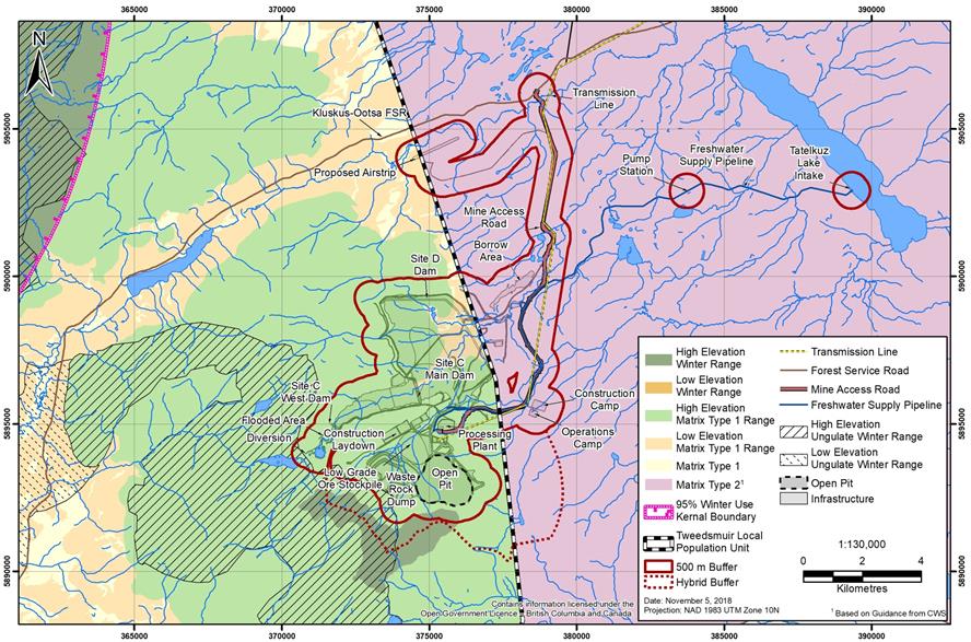
Source: New Gold Inc.
Mortality and changes in health
Land clearing can create forest openings that attract Little brown myotis and Northern myotis, and chemicals used for the Project (e.g. ice and dust treatments for roads or the airstrip) may attract Western toad, to areas where there is a greater risk of collisions with project components resulting in a higher mortality risk. The proponent also identified that the creation of habitat offsetting for fish may introduce fish into Western toad breeding ponds where there could be mortality risk from predation. Project-related traffic on the Kluskus and Kluskus-Ootsa Forest Service Roads, transmission line access roads, and mine access road could cause an increase in collisions between vehicles and Little brown myotis and Northern myotis, Western toad, Grizzly bear, and wolverine, and increase mortality risk for these species. Grizzly bear and wolverine may also experience higher mortality risk from increased access for hunters, and wolverine may also encounter more natural predators.
Chemicals and dust from project-related activities may have potential adverse effects on Western toad health. Although the proponent did not predict any risks to Little brown myotis and Northern myotis health from the Project, the recovery strategy identifies that the introduction and transmission of white-nose syndrome is the greatest risk to bat health.
The proponent predicted an increase in mortality risk for Southern mountain caribou due to a predicted increase in predators and hunters facilitated by the creation of new linear corridors. Moreover, the proponent determined that the mine site was not used as a migration corridor between Tweedsmuir and other local population units. Consequently, the proponent concluded that there would be no effect from the Project on Southern mountain caribou mortality from interaction with project-related vehicles.
Proposed mitigation measures, monitoring and follow-up
The proponent committed to implement the following measures to mitigate potential effects to species at risk and habitat for wildlife species potentially affected by federal authorizations:
For effects of the Project on habitat loss and alteration, the proponent proposed to locate infrastructure in disturbed areas, away from wildlife habitat where possible, and restore and reclaim disturbed wildlife habitats and vegetation areas. The proponent proposed to avoid work during sensitive periods for wildlife. Where this is not possible, the proponent would conduct pre-construction surveys for Little brown myotis and Northern myotis, Grizzly bear, American marten, fisher, and Western toad. If roosting habitat for Little brown myotis and Northern myotis were lost or altered, the proponent would install artificial roosting structures. The proponent would deactivate exploration roads in Southern mountain caribou critical habitat early in the construction phase, and monitor for effects to Southern mountain caribou and moose during winter aerial surveys.
The proponent proposed mitigation measures for sensory disturbances from noise, light, and dust to minimize effects to wildlife habitat, mortality, and health. The proponent also proposed to reduce possible wildlife collisions by posting road signs in wildlife sensitive areas, removing carrion, and avoiding the use of salts and other potential attractants on proponent-controlled roads. The proponent proposed to deter Western toad from the tailings storage facility and pit lake when water is not suitable for wildlife, and conduct salvage activities (capturing and moving the animals to a safe place) if the Project interferes with Western toad breeding habitat. Along the transmission line, the proponent would maintain vegetation at a height that would minimize predator sight lines. The proponent would also institute no hunting or trapping policies for workers on-site and provide wildlife awareness training.
The proponent would also implement Whitebark pine awareness training for staff, and a Whitebark Pine Management Plan including cone collection and rust-resistant seedling propagation for use in mine site reclamation. For Nechako white sturgeon, the proponent proposed mitigation measures consistent with Fisheries and Oceans Canada's Measures to Avoid Causing Harm to Fish and Fish Habitat (2013),including erosion control, retention of vegetation where possible, and revegetation of cleared areas, to avoid or lessen adverse effects on this species at risk.
Predicted residual effects
The proponent concluded that habitat loss and alteration and mortality for bats, mortality and health for Western toad, habitat alteration for Short-eared owl, habitat loss and alteration for moose, habitat loss and alteration for fisher and beaver, and changes in wildlife health for beaver, would be not significant (negligible). It also predicted no residual effects to Western toad health from chemicals and dust. As a result, it did not conduct a cumulative effects assessment for these effects.
The proponent concluded that habitat loss and alteration and mortality for Grizzly bear, and habitat loss and alteration for American marten and wolverine, would be not significant (minor).
The proponent assessed effects to Whitebark pine as an indicator of a broader valued component, which also considered effects to other plant species and ecosystems at risk. The proponent concluded that effects would be not significant (moderate).
The proponent characterized the residual effect to habitat loss and alteration for Southern mountain caribou as not significant (negligible) at the scale of the local population unit, primarily due to the small area of the mine site relative to the size of the local population unit.
6.5.2 Views expressed
Little brown myotis and Northern myotis
Environment and Climate Change Canada and the Carrier Sekani First Nations expressed concern about the effects assessment for bats, and requested clarity about the methodology used to detect bat hibernacula and roosting habitat. Nadleh Whut'en First Nation and Stellat'en First Nation raised concerns about the loss of snags as roosting sites, and requested information on the availability and density of snags and wildlife trees suitable for roosting. Additionally, they requested the installation of bat houses along the transmission line, and bat-specific plans for the maintenance and recruitment of roosting snags.
The proponent responded that baseline acoustic surveys were conducted in the mine site and transmission line local study areas, but hibernacula and roosting-specific surveys were not. A desktop study demonstrated that the geology in the local study area would not support hibernacula. The proponent committed to restricting vegetation clearing to outside of the summer maternal roosting period; conducting pre-construction surveys to identify or confirm potential roosts, hibernacula, and bat activity; and installing bat houses along the transmission line.
Short-eared owl and Rusty blackbird
Environment and Climate Change Canada requested specific surveys during breeding and migration for Short-eared owl, and also targeted surveys at the mine site and the proposed new alignment of the transmission line for Short-eared owl and Rusty blackbird to capture inter-seasonal and inter-annual variation. In response, the proponent conducted aerial and ground surveys to assess the quality of Short-eared owl habitat along the transmission line. The surveys identified no suitable breeding habitat and no Short-eared owls, which confirmed the results of the proponent's previous work. The proponent did not conduct targeted surveys for Rusty blackbird because the species had already been detected during previous baseline surveys, and stated that potential effects to Rusty blackbird would be mitigated by minimizing effects to wetlands, the Wetland Management Plan, and other mitigation measures for migratory birds.
Western toad
Environment and Climate Change Canada disagreed that the effect would be short-term in duration and reversible for habitat loss and alteration, and requested mitigation measures for effects to amphibians in terrestrial habitat. The proponent provided its view that mitigation for Western toad terrestrial habitat relies on measures to minimize disturbance and ensure Western toads are monitored along roadways to minimize mortality during dispersal. Environment and Climate Change Canada raised concerns that salvage is not a suitable mitigation measure to address effects of habitat loss and mortality because the survival of translocated individuals is highly uncertain. However, salvage may be appropriate to reduce direct impacts in situations where options for habitat mitigation are limited.
Nadleh Whut'en and Stellat'en First Nations requested the proponent adopt additional mitigation measures including fencing at toad crossing locations, best management practices for avoiding road impacts, measures for salvage, and steps to enhance identification of breeding sites. The proponent committed to consulting with Nadleh Whut'en and Stellat'en First Nations on the additional mitigation measures.
Grizzly bear
Lhoosk'uz Dené Nation, Ulkatcho First Nation, and B.C.'s Ministry of Forests, Lands, and Natural Resource Operations and Rural Development expressed concern about effects to Grizzly bear habitat and mortality from increased motorized access to habitat, camp workers' recreational activities, and attractants. B.C.'s Ministry of Forests, Lands, and Natural Resource Operations and Rural Development recommended the proponent consider timing restrictions for activity around Grizzly bears, particularly around high value spring and fall forage habitat. The proponent committed to mitigation measures to address habituation, attractants, and disturbance.
Moose
Lhoosk'uz Dené Nation, Ulkatcho First Nation, and the public raised concerns about declining moose populations in the region, and habitat loss and alteration from additional linear corridors. Lhoosk'uz Dené Nation and Ulkatcho First Nation requested that population surveys be part of baseline and future monitoring to confirm the predictions of the proponent's assessment. The proponent committed to conducting winter aerial surveys during pre-construction, and then every five years to track moose abundance and distribution within the mine site.
Wolverine, American marten, fisher, and beaver
Lhoosk'uz Dené Nation and Ulkatcho First Nation expressed concern with the selection of American marten and beaver as indicator species representing all furbearers because these species do not represent the requirements for wide ranging mesocarnivores such as lynx, wolverine and fisher. Furthermore, they expressed concern with the rationale for not addressing lynx habitat, the scale of the assessment of fisher and wolverine, and the habitat modelling. In response, the proponent conducted an assessment of potential effects to habitat loss and alteration for wolverine and fisher, but did not include lynx because the potential effects to furbearer species were adequately represented.
Whitebark pine
Environment and Climate Change Canada expressed concern that the Project could result in the destruction of Whitebark pine critical habitat, jeopardizing recovery or survival of the species. They requested an analysis of overlap between the Project and Whitebark pine critical habitat, and of mitigation and monitoring measures and their effectiveness. In particular, Environment and Climate Change Canada was concerned about transplantation, the long-term protection of Whitebark pine in proposed offset areas, and maintenance of alternate Clark's nutcracker food sources near Whitebark pine areas. The proponent responded that the establishment of a blister rust-resistant Whitebark pine population would create habitat for Clark's nutcracker, and that use of alternate natural food sources for Clark's nutcracker would not be a viable strategy. The proponent also provided a list of mechanisms in place to restrict forestry activities in offset areas, and stated it is the only company with mineral tenures in the offset areas.
Nechako white sturgeon
Nadleh Whut'en First Nation, Stellat'en First Nation, Saik'uz First Nation, and Nazko First Nation raised the high cultural importance of Nechako white sturgeon to their communities. Due to its status as an endangered species, they are unable to harvest Nechako white sturgeon and are active in efforts to promote its recovery.
Southern mountain caribou
Environment and Climate Change Canada requested the proponent evaluate telemetry data from both the Tweedsmuir local population unit and the Itcha-Ilgachuz herd to determine movement and interaction between herds over time, and to provide a description of the predicted effects of the project on movement and mortality risk. They also requested that the proponent include sensory buffers to calculate indirect effects to critical habitat during construction and operations, comprised of a three kilometre buffer around the open pit to the height of land, and a 500 metre buffer around the rest of the mine site components. Additionally, they requested surveys for mineral licks and commitment from the proponent to work with Indigenous groups to advise Environment and Climate Change Canada of mineral lick locations and to develop mitigation measures. In response, the proponent committed to engaging with B.C.'s Ministry of Forests, Lands, and Natural Resource Operations and Rural Development and Indigenous groups to develop appropriate mitigation to minimize effects if a mineral lick is identified during pre-construction surveys, construction, or operations.
Nadleh Whut'en First Nation, Stellat'en First Nation, Lhoosk'uz Dené Nation, Ulkatcho First Nation, Nazko First Nation, and Tsilhqot'in Nation expressed concern with declining Southern mountain caribou populations in the region and stated that there is insufficient information to characterize the current status of the species and its habitat. Nadleh Whut'en First Nation and Stellat'en First Nation maintained that due to the current sensitivity and cultural importance of the species, there should be no net loss to Southern mountain caribou populations or functional habitat as a result of the Project, and that any loss should be considered significant. Additional information was requested concerning restoration plans, policies, and programs the proponent had committed to effectively characterize, mitigate, and monitor impacts to Southern mountain caribou, including how Indigenous traditional knowledge would be integrated. Tsilhqot'in Nation made a similar request for more information and consultation about potential Project effects to Southern mountain caribou and mitigation measures.
The proponent responded that proposed mitigation measures are aligned with the Recovery Strategy for the Woodland Caribou, Southern Mountain population (Rangifer tarandus caribou) in Canada, and that a Wildlife Management Plan would be developed in response to views expressed by Indigenous groups and Environment and Climate Change Canada. The proponent proposed to establish an Environmental Monitoring Board, with Indigenous representation, to review and monitor environmental compliance and the effectiveness of mitigation measures and management plans, and to provide a mechanism for communication between Indigenous groups and the proponent.
Lhoosk'uz Dené Nation and Ulkatcho First Nation expressed concern about the lack of clarity surrounding how changes to population dynamics would be monitored. In response, the proponent committed to conducting winter aerial surveys for abundance and distribution within the mine site portion of the regional study area prior to the start of construction, and every five years thereafter, during active mine operations, and to supporting regional initiatives with respect to Southern mountain caribou. Lhoosk'uz Dené Nation and Ulkatcho First Nation requested to be included in discussions regarding the development of study designs, which the proponent agreed to.
6.5.3 Agency analysis and conclusion
Significance of environmental effects linked to federal authorizations
Project components enabled by federal authorizations would result in habitat loss and alteration of:
- 823 hectares of moderate and high value habitat for Little brown myotis and Northern myotis, which may include high value cavity nesting and roosting habitat.
- 1 224 hectares of moderate and high value habitat for Western toad.
- 1 951 hectares of spring, 2 513 hectares of summer, and 2 746 hectares of fall habitat for Grizzly bear.
The Agency considers these effects to be low magnitude, given that all project components together would result in habitat loss and alteration of 2 to 2.8 percent of the habitat in the regional study area. The Agency finds the effect from habitat loss and alteration to be not significant because the effect will occur once in frequency, and is local and confined to the mine site, chronic in duration because it will persist until post-closure, and reversible with reclamation. As these are species at risk, the Agency considered the effects within a high context, indicating that these species have limited resilience to stress.
Project components enabled by federal authorizations would result in habitat loss and alteration of:
- 1 165 hectares of growing and 876 hectares of spring habitat for moose.
- 1 787 hectares of growing and winter habitat for American marten.
- Six hectares of growing habitat for beaver.
- 38 hectares of denning habitat for fisher.
- 1 014 hectares of winter habitat and 1 665 hectares of growing habitat for wolverine.
The Agency considers these effects to be low magnitude, given that all project components together would result in minimal habitat loss and alteration of 0.4 to 2.7 percent of the habitat in the regional study area. The Agency finds the effect from habitat loss and alteration for these species to be not significant because the effect would be limited in geographic extent to the local study area, occur once in frequency, be chronic in duration, and be reversible when habitat is reclaimed at the mine site. As these are not species at risk, the Agency considered the effects within a moderate context due to the species' resilience to stress, except for wolverine, which was considered to have a high context.
Project components enabled by federal authorizations would result in habitat alteration of 17 hectares of growing habitat for Short-eared owl. The proponent used its assessment for Wilson's snipe (Section 6.4) as a proxy for Rusty blackbird), which indicated that 572 hectares of moderate to high-value habitat for Wilson's snipe would be lost or altered in the local study area, representing 21 percent of habitat in the local study area and 2 percent in the regional study area. The Agency also found that project components enabled by federal authorizations would result in the loss of 319.7 hectares and the alteration of 123.3 hectares of wetlands in the local study area (Section 6.2), which is habitat for Rusty blackbird. It is unknown whether all effects to wetlands are accounted for in the assessment of Wilson's snipe habitat, or if the effects may be additive in determining habitat loss and alteration for Rusty blackbird. Due to this uncertainty, the Agency is of the view that the effect to Short-eared owl and Rusty blackbird could be moderate in magnitude. However, the effect is considered not significant because the effect would be local in geographic extent, occur once in frequency, be chronic in duration, and be reversible when habitat is regenerated and water quality is suitable for wildlife species following the post-closure phase.
Project components enabled by federal authorizations would result in habitat loss and alteration of 115 hectares of the critical habitat for Whitebark pine, and an additional 425 hectares of regeneration/recovery habitat, which together represents 13 percent of the habitat available in the local study area. The use of the local study area is more appropriate for the assessment of Whitebark pine because it is a fixed species with no ability to move. Considering this is the critical habitat of an endangered species, the Agency finds the effect to be moderate in magnitude because it would be a measurable change; to be confined to the local study area in geographic extent; to occur once in frequency; but, to be chronic in duration and irreversible in the area affected. The effect is not significant.
In 2018, the Minister determined that the Southern mountain caribou is facing imminent threats to its recovery, and released an Imminent Threat Assessment for Southern Mountain Caribou.Footnote 12 The imminent threat assessment stated that the most important threat to the recovery of Southern mountain caribou is unsustainable predation resulting from habitat alteration, changes to predator-prey dynamics, facilitated movement of predators, and disturbance/displacement. The Tweedsmuir local population unit has and continues to experience declines; however, as a local population unit with a population size over 100 individuals, it has some resilience compared to smaller populations and will likely be able to withstand the current threats even if they are not immediately addressed. The effects to Southern mountain caribou would still be considered within a high context, given that it has been severely affected by other activities and natural changes.
The majority (but not all) of the habitat loss and alteration presented in Table 13 for critical habitat for Southern mountain caribou would be attributed to project components enabled by federal authorizations. The Agency disagrees with the proponent that the magnitude of the effect of the Project would be negligible, because effects to critical habitat and the corresponding effects to predation, and disturbance and displacement of Southern mountain caribou, are important threats to recovery. Given the size of the local population unit and the limited use of the project area by Southern mountain caribou, the effect to habitat loss and alteration is considered not significant because it would be low in magnitude; be local in geographic extent; occur once in frequency but be chronic in duration over the life of the Project; and be irreversible for project components that will not be reclaimed, and reversible for sensory disturbance.
Key mitigation measures, monitoring and follow-up
The Agency has considered the mitigation measures proposed by the proponent, advice from expert federal authorities, and comments received from Indigenous groups and the public in identifying the following key mitigation measures to be implemented by the proponent:
- Identify, prior to construction, time periods during which construction activities must be carried out to protect Western toad, wolverine, American marten, fisher, and Southern mountain caribou during sensitive life stages.
- Conduct pre-construction surveys and develop and implement additional mitigation measures to protect Western toad, wolverine, American marten, fisher, and Southern mountain caribou.
- Conduct annual surveys for amphibian activity in wetlands.
- Conduct pre-construction surveys to identify/confirm potential hibernacula and roost features, the summer roosting period, and to validate habitat suitability models, for Little brown myotis and Northern myotis, and establish buffers (no work zones) around active hibernacula and active roosts.
- Install, prior to construction, roosting structures to offset any loss of roosting habitat for Little brown myotis and Northern myotis.
- Conduct pre-construction surveys for potential denning habitat for Grizzly bear and implement measures to mitigate the loss of denning habitat caused by the Project.
- Conduct pre-construction surveys for potential moderate to high-value nesting and foraging habitat for Short-eared owl and implement measures to mitigate the loss of habitat caused by the Project.
- Implement progressive reclamation using local native vegetation, including conifers such as Whitebark pine, in suitable sites to develop appropriate habitats capable of supporting Southern mountain caribou and other species of interest to Indigenous groups.
- Place woody debris on the surface of upland slopes and between rocks and along slopes to provide habitat features for security of Southern mountain caribou and to foster habitats not suitable for alternate prey species along the transmission line.
- For Whitebark pine, carry out activities to support progressive reclamation, including production of rust-resistant seedlings, stand enhancement measures, measures to support Clark's nutcracker, identify adaptive measures to guide reclamation practices, and transplant healthy trees from impacted areas to undisturbed areas or designated reclamation areas.
The Agency assessed potential cumulative effects to Grizzly bear, American marten, wolverine, Whitebark pine, and Southern mountain caribou and identified additional mitigation measures for Southern mountain caribou in Section 7.3.
Potential adverse effects from the Project on species at risk
The Agency considers the mitigation measures to avoid sensitive roosting habitat, including conducting pre-construction surveys, establishing buffers around hibernacula and maternity roosts, and supplementing lost roosting habitat with roosting structures, to be necessary to reduce potential effects from the Project on Little brown myotis and Northern myotis. Measures to minimize noise and light, and precautions to avoid the transmission of White nose syndrome, are appropriate to minimize the threats to bats. Mitigation measures to address effects to wetlands would also reduce potential effects to Little brown myotis, Northern myotis, Short-eared owl, and Rusty blackbird, and mitigation measures proposed for migratory birds would also reduce or avoid effects to bird species at risk.
For Western toad, measures such as avoiding sensitive periods, conducting pre-construction surveys, establishing buffers around Western toad habitat, signage for drivers and monitoring along roadways to reduce mortality, and surveys for use of wetlands, are necessary to reduce potential effects from the Project. Although avoiding and minimizing impacts should be considered first, if the proponent needs to salvage Western toad, a salvage plan and a follow-up program are required to determine the effectiveness of this mitigation measure.
For Grizzly bear and wolverine, conducting pre-construction surveys for sensitive denning habitat; implementing progressive reclamation at the mine site; minimizing noise, light, and physical and chemical attractants; removing carrion along proponent-controlled roads; and prohibiting employees of the Project from hunting and trapping are appropriate to minimize the threats.
The Agency considers the mitigation measures to support the identification, selection, propagation, and planting of blister rust-resistant individuals, and stand enhancement measures to enhance use by Clark's nutcracker, to be necessary to reduce potential effects of the Project on Whitebark pine. Due to the uncertainty about the effectiveness of the proposed mitigation measures, a follow-up program is required to verify the success of seedling planting and tree health, and use by Clark's nutcracker. If data indicates that there is insufficient seed production by Whitebark pine to support the population of Clark's nutcracker that is required for regeneration, the Agency recommends that adaptive management measures such as supplemental feeding be identified.
The Agency has determined that the standard measures proposed by the proponent for Nechako white sturgeon, including minimizing clearing of riparian vegetation and stabilizing shorelines or banks disturbed by construction activities, would reduce effects on this species at risk.
The measures proposed by the proponent to avoid and lessen effects to Southern mountain caribou, such as minimizing sensory disturbance, scheduling project activities during the "least risk window," providing habitat features that provide security for Southern mountain caribou and deter alternate prey species, and conducting progressive reclamation, would reduce effects on this species at risk. The proponent has proposed to monitor potential effects of the Project through aerial surveys conducted at the commencement of construction and every five years until the end of operations. The proponent has also proposed to deactivate and restore exploration roads during construction and to support non-habitat based regional initiatives when they become available.
Key mitigation measures, monitoring and follow-up
The Agency has considered the mitigation measures proposed by the proponent, advice from expert federal authorities, and comments received from Indigenous groups and the public in identifying the following key mitigation measures to be implemented for species at risk:
- Control lighting required for all phases of the Project, including direction, timing, and intensity, to avoid adverse effects on species at risk.
- Install and maintain signs along proponent-controlled roads warning drivers of the possibility of wildlife encounters in areas of high wildlife activity.
- Implement a salvage plan that identifies relocation sites and outlines salvage operations prior to clearing activities that cannot be scheduled outside of sensitive periods in potential Western toad habitat.
- Implement measures (e.g. fencing) to deter amphibians if amphibians exhibit movements towards potentially contaminated water bodies.
- Avoid using salt for de-icing or traction control purposes and remove carrion within 24 hours of discovery on proponent-controlled roads to minimize attraction of wildlife to roadsides.
- Manage snow bank height and create breaks in snow banks at periodic distances along proponent-controlled roads to allow wildlife to escape.
- Following initial clearing, conduct vegetation maintenance under the transmission line right of way at no lower than one metre from the ground on an average basis, except where not safe to do so, to reduce predator sight lines.
- Adhere to federal guidance to prevent the spread of White nose syndrome, as outlined in Western Canada White Nose Syndrome Transmission Prevention.Footnote 13
Monitoring and follow-up
- Develop a follow-up program to monitor the success of the salvage plan for Western toad and to monitor the usage of buffer zones and roosting structures to determine the effectiveness of the mitigation measures for Little brown myotis and Northern myotis.
- Develop a follow-up program to verify the accuracy of the EA for Whitebark pine that includes: monitor newly planted areas on-site a minimum of every five years to assess the success of seedling establishment and overall health of each tree, satellite tag Clark's nutcracker to determine habitat usage and dispersal range, and identify adaptive management measures such as supplemental feeding after mine operations and during reclamation.
Conclusions
Taking into account the implementation of the mitigation measures and follow-up program described above, the Agency is of the view that project components and activities enabled by federal authorizations are unlikely to result in significant adverse environmental effects on wildlife and species at risk.
The Agency is also of the view that the proponent's mitigation measures, measures required by recovery strategies and action plans, and key mitigation measures and follow-up program identified by the Agency, would avoid or lessen effects on species at risk or their habitat.
6.6 Health and Socio-Economic Conditions – Indigenous Peoples and the Public
In its assessment of the Project's effects to Indigenous health and socio-economic conditions, the Agency considered effects to human health from noise; changes to the quality of air, water, soil, and country foods; and effects to socio-economic conditions from reduced access to and quantity of country foods.
In its assessment of the Project's effects to public socio-economic conditions, the Agency considered effects to businesses owned by members of the public (i.e. recreation and tourism opportunities, trapping, guide outfitting, and an agricultural range tenure) from displacement or changes to access, and changes to the quality of experience. The Agency considered effects to lands and resources that are relied on by these businesses that would result from the construction, operation, and closure of mine components that require federal authorizations, as listed in Table 4 of Section 6.1.
The Agency concludes that the Project is not likely to result in significant adverse environmental effects to health and socio-economic conditions of Indigenous people, and to public socio-economic conditions. The information that supports the Agency's conclusion follows.
6.6.1 Proponent's assessment of environmental effects
Human health
Effects to human health from noise
Health Canada recommends adherence to the World Health Organization'sFootnote 14 recommendation that noise levels should remain below 55 A-weighted decibels (the average sound level over a specified duration given that noise levels vary over time) to minimize community annoyance from noise during the daytime or non-sleep hours. Major noise sources associated with the Project are from blasting and mining equipment, which would primarily be located in and around the open pit; noise from the pump station associated with the freshwater supply system on Tatelkuz Lake; and aircraft. The proponent concluded that all mine site noise sources would be generated almost entirely within the mine site footprint, where there are no permanent residences. Temporary land users conducting traditional activities near the open pit could experience sensory disturbances from noise. The proponent determined that noise from the mine site would attenuate to 30 A-weighted decibels approximately four kilometres to the east and west, and six kilometres to the north and south, and predicted that the Project not would cause sleep disturbances. The airstrip could be used by aircraft as large as a Boeing 737-200, which would generate noise up to 72 A-weighted decibels at one Lhoosk'uz Dené Nation residence at Indian Reserve 28. As such, there may be temporary issues related to speech comprehension during take-off and landing; however, it is expected that aircraft activity would occur infrequently (approximately three return flights per week) and during daylight hours to minimize the potential for sleep disturbance. Noise from the pump station would attenuate to 30 A-weighted decibels approximately 200 metres from the pump station over ground, and 300 metres over water.
Effects to human health from changes to quality of air, water, soil, and country foods
The Project may affect the quality of water, soil, and country foods through dust deposition and changes to surface water and groundwater quality. To assess potential effects to human health from the Project, the proponent conducted a Human Health Risk Assessment, which is a tool to estimate the nature and probability of adverse health effects in people who may be exposed to chemicals from many different environmental pathways.
The proponent predicted that all non-carcinogenic ground-level concentrations of nitrogen dioxide, sulphur dioxide, fine particulate matter (PM2.5), coarse particulate matter (PM10), and carbon monoxide would be below Health Canada's target risk levels, meaning they would have no adverse effect on human health. All other contaminants of potential concern were predicted to be below Health Canada's target risk levels, except for arsenic and cyanide. The proponent explained that the baseline level of arsenic already exceeds Health Canada's target risk level for non-carcinogenic and potentially carcinogenic effects. The Project's water treatment is expected to decrease arsenic levels in water to below baseline, and the proponent's Human Health Risk Assessment predicted that the non-carcinogenic and potentially carcinogenic effects will be reduced, but not below Health Canada's target risk level. The proponent stated that the Human Health Risk Assessment for arsenic is extremely conservative and overestimates the risk to human health. Health risks for non-carcinogenic effects linked to cyanide are predicted to exceed Health Canada's target risk levels but the assessment overestimated risk by not accounting for removal of cyanide through water treatment, attenuation, or degradation in the tailings storage facility.
The proponent re-evaluated the conclusions of the Human Health Risk Assessment following the changes to the Project design (including the proposed new alignment of the transmission line) and determined that human health risks would remain the same or be reduced as compared to the original predictions.
Proposed mitigation measures, monitoring and follow-up for health effects
The proponent proposed health-related mitigation, monitoring, and follow-up measures including the following:
- Reduce noise emissions through commitments related to equipment and vehicle selection, placement, use, and maintenance.
- Develop a Noise Management Plan in consultation with Indigenous groups and a formalized Noise Complaint Response and Resolution Plan.
- Use smaller aircraft (e.g. Dash 8-100) instead of larger aircraft whenever possible, and limiting taxiing time of aircraft and low altitude flights except on final approach and take off.
- Establish speed limits on proponent-controlled roads, taking into account provincial standards, to minimize noise and vibration, fugitive dust, and for safety reasons.
- Develop an Air Quality and Emissions Management Plan in consultation with Indigenous groups to identify monitoring locations, parameters, frequency, and reporting.
- Mitigate, during all phases of the Project, emissions of fugitive dust.
- Inform the public (e.g. through signage) that consumption of surface water in the tailings storage facility and pit lake is not advisable during closure and post-closure, and that Davidson Creek may not be potable during the months of April and May during post-closure.
- Use conventional Sulphur dioxide/air treatment for cyanide destruction during operations, prior to depositing tailings in the tailings storage facility.
- Develop a Country Foods Monitoring Plan to monitor metal concentrations in specific indicator plants, small and large mammals, and fish.
Mitigation measures for addressing changes to surface water and groundwater quality are discussed in Section 6.1.
Predicted residual effects to human health
The proponent predicted residual effects to the health of Indigenous peoples to be not significant (negligible) with high confidence, following the implementation of mitigation measures, for both noise and reduced quality of air, water, soil, and country foods. The proponent did not conduct a cumulative effects assessment because its predicted residual effects to human health were negligible.
Socio-economic conditions
Effects to socio-economic conditions from reduced access to and quantity of country foods
With respect to Indigenous peoples, the Project could cause changes to the access and quantity of country foods, commercial land use, and future land use options. The proponent considered the effects of these changes to cost of living, food security, social equity, business activities, and economic development, in its assessment of the effects of changes to the environment from the Project on the socio-economic conditions of Indigenous peoples. The proponent determined that there would be no interactions between the Project and socio-economic conditions for Nazko First Nation, Ts^ilhqot'in Nation, Métis Nation British Columbia, and Nee-Tahi-Buhn Band, and did not consider them further in the assessment.
The proponent's assessment of food security for Nadleh Whut'en First Nation, Stellat'en First Nation, Saik'uz First Nation, Lhoosk'uz Dené Nation, Ulkatcho First Nation, and Skin Tyee Nation considered the potential for project-related changes to the environment to reduce the amount of country foods available to Indigenous households due to reduced access, availability, and knowledge related to country foods. The potentially affected Indigenous communities currently consume country foods, and experience food insecurity with respect to both store-bought and country foods. By reducing the abundance and distribution of country foods sources and potentially increasing the effort required to obtain them, the Project may result in decreased access to safe and nutritious country foods. This could have a corresponding effect on the cost of living for Indigenous peoples because they may need to spend more on store-bought food or on travel to obtain country foods.
The proponent utilized its analysis of effects from the Project on hunting success of moose as a proxy for food security. Based on a conclusion of no significant adverse effects from the Project to moose, the proponent did not find any residual effects to food security from changes in the ability to hunt moose. Given this conclusion, the proponent anticipated no residual effects to cost of living or Indigenous socio-economic conditions from the Project. The proponent determined that there was no interaction between the effects of the Project on the environment and the social equity of Indigenous peoples, meaning the Project will not increase socio-economic disparity or conflict between family groups, and did not consider it further in the assessment.
In terms of business activities and economic development, the proponent identified 44 land-based and non-land-based Indigenous-owned businesses within the regional study area, including traplines, commercial forestry, viniculture, ecotourism, mushroom harvesting, and non-timber forest products. The proponent did not identify any interaction between changes to the environment caused by the Project and effects to business activities or economic development, and did not consider it further in the assessment.
Effects to public socio-economic conditions from displacement or changes to access
The construction, operation, and closure of project components enabled by federal authorizations could potentially disrupt access and displace land users where the Project footprint overlaps with the area or activity that supports a business owned by a member of the public. The construction of project components enabled by federal authorizations would disrupt access to a small portion of one trapline registered to a member of the public; and small portions of tenures belonging to Batnuni Lake Guide and Outfitters Ltd. and Fawnie Mountain Outfitters, who specialize in moose and bear hunting. However, the proponent stated that these tenures would remain accessible from the Kluskus-Ootsa Forest Service Road. Laidman Lake Ecolodge and Tatelkuz Lake Resort, who specialize in outdoor recreational experiences such as fishing and canoeing, could also be affected by changes to access. Access to portions of one agricultural range tenure would also be affected.
The proponent stated that the existing access to the shores of Tatelkuz Lake, where the freshwater supply system would be located, is generally limited because there is no public road or boat launch, so recreational fishing and canoeing is unlikely to occur. Construction of the freshwater supply system could further impede access, resulting in temporary relocation to other areas causing changes to fishing success rates and increased fishing effort, while construction of the service road associated with the freshwater supply system pipeline could increase access to the area by other users and increase competition for resources. However, the proponent stated that it could not assess the magnitude and intensity of effects to recreational fisheries because there have been no recreational catch surveys in the regional study area to date.
Effects to public socio-economic conditions from changes to the quality of experience
The proponent stated that the construction, operation, and closure of project components enabled by federal authorizations could potentially reduce the quality of land use experiences due to sensory disturbance and a reduction in wildlife resources. During the construction and closure phases, noise and dust disturbance due to the presence of project-related equipment and vehicles could disrupt outdoor recreational experiences or wilderness resource values in the area of the freshwater supply system, and particularly activities related to the Tatelkuz Lake Resort, recreation reservations, and the Messue Wagon Trail. This effect would be minimal during the operations phase, once the freshwater supply system is installed. The Project could also reduce wildlife populations within and adjacent to project components, but overall wildlife populations would remain unaffected in other portions of guide outfitters' and trappers' tenures.
Proposed mitigation measures, monitoring and follow-up for socio-economic effects
The proponent committed to implement the following measures to mitigate potential effects to food security, displacement, changes to access, and the quality of experience for public socio-economic conditions:
- Develop and implement a Wildlife Management Plan and a Transportation and Access Management Plan that aim to reduce harm to species that are hunted for food, including implementing speed limits on the Kluskus and Kluskus-Ootsa Forest Service Roads.
- Conduct winter moose surveys at a suitable scale to monitor the local population prior to construction, and then every five years during mine operations, to monitor trends.
- Provide the construction schedule to holders of provincially-registered traplines 30 days prior to the start of construction; and resolve any issues related to access as per appropriate industry and provincial standards, guidelines, and best practices, including through compensation or accommodation.
- Provide maps and early notification of project development and other physical work to affected forestry stakeholders, and consult forest licensees throughout the life of the Project.
- Establish a Traditional Knowledge/Traditional Land Use Committee, Environmental Monitoring Board, and Access Management Working Group with participation by Indigenous groups.
- Develop a follow-up program to monitor for effects of the Project on Indigenous food security, and develop adaptive management measures such as working with Indigenous groups to identify and deactivate orphan roads to reduce habitat fragmentation in the regional study area, either through in-kind support or by assisting in accessing funding.
The proponent also indicated that mitigation measures for dust and noise; habitat loss and alteration; mortality for moose, grizzly bear, and furbearers (Section 6.5); emissions (Section 6.9); and fish and fish habitat (Section 6.3); would reduce effects.
Predicted residual effects to socio-economic conditions
The proponent determined that with the implementation of mitigation measures, there would be no residual effects on Indigenous groups' food security, cost of living, business activities, and economic development from the Project. The proponent also concluded that, while the Project would result in residual socio-economic effects on recreation and tourism opportunities, trapping, guide outfitting, and agricultural range tenure, these effects would be not significant (minor).
Although the proponent stated that other land uses within the regional study area, and Mountain pine beetle and forest fires could also disrupt access to or use of hunting, trapping, guide outfitting, and agricultural range tenures, land use objectives are managed via the District of Vanderhoof's Land and Resource Management PlanFootnote 15, and concluded that the Project's overall contribution to cumulative socio-economic effects in the regional study area would be not significant (minor).
6.6.2 Views expressed
Human health
Health Canada expressed concern about the effectiveness of the proponent's dust control measures. The proponent's initial air quality model and Human Health Risk Assessment used a 95 percent dust mitigation effectiveness value for haul road dust emissions. They suggested that a dust mitigation effectiveness of 70 percent to 85 percent is typical. The proponent updated its air quality modelling to 70 percent dust mitigation effectiveness and found exceedances above the original assessment for total suspended particles, fine particulate matter, and particulate matter, but that levels at the worker camp and more distant areas would be almost entirely within B.C. and Canada's ambient air quality objectives and standards.
Lhoosk'uz Dené Nation and Ulkatcho First Nation raised concerns that four permanent and seasonal residences may experience noise levels between 65 and 72 A-weighted decibels two to three times per week during aircraft take-off, and increased noise during blasting. Nadleh Whut'en First Nation and Stellat'en First Nation commented that the proponent's assessment did not consider their traditional knowledge when determining receptor locations for noise along the linear components, and requested to be involved in establishing culturally-appropriate receptor locations. The proponent committed to implement a Noise Management Plan to monitor noise during operations at select receptor locations to verify the predictions of the EA and confirm the effectiveness of mitigation measures. The proponent also collaborated with the Carrier Sekani First Nations to develop the proposed new alignment of the transmission line to address concerns about potential effects of the original alignment on valued components and the Carrier Sekani First Nations' Aboriginal rights.
Stellat'en First Nation raised a health concern with the proponent about the use of pesticides for invasive species management in its traditional territory, and the proponent committed to comply with Stellat'en First Nation's herbicide use policy for work conducted within its traditional territory.
Country foods
Lhoosk'uz Dené Nation, Ulkatcho First Nation, and the Carrier Sekani First Nations all highlighted the importance of country foods to their communities. Lhoosk'uz Dené Nation and Ulkatcho First Nation noted that the proponent should ensure effects to country foods are not unnecessarily over-estimated as that could result in community members avoiding them. These groups expressed a need for Nation-specific information on consumption and baseline levels of chemicals in country foods, and asked for the proponent to clearly communicate monitoring results in plain language to the communities. The proponent responded that the Human Health Risk Assessment followed Health Canada guidance, which typically results in a conservative estimation of risk, and committed to engaging with Indigenous groups on the development and implementation of a Country Foods Monitoring Plan including monitoring approaches that will effectively address and minimize community members' perceived risk in relation to country foods.
Saik'uz First Nation raised that the proponent's assessment focused on the consumption of berries and did not account for a wide enough range of country foods and the associated impacts to health from the Project. The proponent responded that the assessment considered specific species of wild game, fish, and vegetation, including White-tailed deer, Rainbow trout, Black huckleberries, and willow. The proponent committed to including specific components in the Country Foods Monitoring Plan, such as soil and vegetation samples collected together in the same place at the same time, and engaging Indigenous groups on the vegetation, fish, and wildlife species to target for sampling.
Health Canada requested that the proponent explain why it only proposes to collect and assess recently matured, dust-free, healthy leaves for the Country Foods Monitoring Plan, given that dust deposition on plants was considered a potential exposure pathway. In addition, they clarified that both washed and unwashed berries should be collected to represent actual exposure scenarios. The proponent agreed to consider washed and unwashed vegetation in the next iteration of a Country Foods Monitoring Plan.
Socio-economic conditions
The Carrier Sekani First Nations highlighted inequalities in local food security between Indigenous and non-Indigenous populations and noted that the Carrier Sekani First Nations have a higher reliance on country foods and higher food insecurity for store-bought foods compared to other populations. Stellat'en First Nation and Nadleh Whut'en First Nation commented that Nation-specific baseline studies had not been incorporated into the proponent's assessment of socio-economic conditions of Indigenous peoples. Similarly, Lhoosk'uz Dené Nation and Ulkatcho First Nation commented on the importance of establishing a robust and accurate baseline against which health and socio-economic effects of the Project could be compared in the future. The proponent responded by incorporating baseline information from the Carrier Sekani First Nations' studies into an updated assessment of project-related effects to the socio-economic conditions of Indigenous peoples, provided capacity funding to Ulkatcho First Nation to complete a socio-economic and health study, and committed to considering baseline information from Ulkatcho First Nation once available.
Members of the public, specifically business owners, expressed concerns regarding potential effects to their use of lands near the Project, and how they might be compensated for any adverse socio-economic effects. The proponent responded that it had committed to implementing mitigation measures that would reduce or avoid effects to other tenure holders, and that it would be open to continuing discussions regarding mitigation measures. Batnuni Lake Guide and Outfitters Ltd. expressed concern that the Project would have an adverse effect on its ability to carry out horseback hunting opportunities and its ability to provide a wilderness experience in an area designated for non-motorized recreational use, away from the pressures of local hunters. At the time of writing this report, discussions consistent with B.C.'s Ministry of Forests, Lands, and Natural Resource Operations and Rural Development's Practical Guide to Effective Coordination of Resource TenuresFootnote 16 were ongoing between the proponent and Batnuni Lake Guide and Outfitters Ltd.
6.6.3 Agency analysis and conclusion
Analysis of the effects
The health and socio-economic conditions of Indigenous peoples have been affected by other projects or activities, so the Agency considered the effects of the Project within a moderate context. Noise levels where Indigenous people may be practicing traditional activities are generally below Health Canada recommended thresholds and are unlikely to result in community annoyance or disturbed sleep. The Agency acknowledges concerns raised by Lhoosk'uz Dené Nation and Ulkatcho First Nation that noise from aircraft take off may cause limited community annoyance to one Lhoosk'uz Dené family residing at Indian Reserve 28 and temporary land users in the area, during the construction phase only, and recommends that flights be limited to daylight hours only. The Agency finds the effect from noise to be not significant because the effect would be low in magnitude, local in geographic extent, long-term in duration because noise from the pump station would continue into closure, intermittent to continuous in frequency depending on the noise source, and reversible.
Project effects are predicted to result in small contributions to contaminant exposure risk for Indigenous peoples. Predicted levels of contaminants of potential concern would result in acceptable exposure risks based on Health Canada criteria, except for arsenic and cyanide. Arsenic levels were found to be above Health Canada's target risk level for carcinogenic and non-carcinogenic effects in baseline conditions, and would not be expected to increase as a result of the Project. For cyanide, the Agency recognizes that the proponent will treat tailings to reduce cyanide concentrations prior to disposing them in the tailings storage facility and agrees that exposure in the Human Health Risk Assessment was conservative (exceedances were only predicted for individuals spending all their time in the Project area and consuming exclusively country foods originating from there). The Agency is of the view that the Project will have a measurable but low contribution to human health risk from exposure to arsenic and cyanide, and the other contaminants of potential concern that were evaluated in the Human Health Risk Assessment. Based on Health Canada's advice, the Agency acknowledges that there is uncertainty about the proponent's ability to achieve 95 percent dust mitigation effectiveness, but the proponent's modelling utilizing 70 percent dust mitigation effectiveness predicted exceedances that were limited to areas within and close to the source of emissions within the local study area, and were within B.C. and Canada's ambient air quality objectives and standardswhere Indigenous people were more likely to be located.
It is unlikely that an Indigenous person spending an average amount of time (i.e. less than the full year) in the vicinity of the mine site or consuming country foods within the local study area would experience an increased health risk due to the Project. An increased lifetime cancer risk higher than Health Canada's target risk level was only predicted for individuals spending all their time in the Project area and consuming exclusively country foods originating from there. The Agency agrees with the proponent's analysis that the original analysis and conclusions of the Human Health Risk Assessment remain unchanged following the proponent's changes to the Project. The Agency finds the effect on human health from changes to quality of air, water, soil, and country foods to be not significant because the effect would be low in magnitude, local in geographic extent, long-term in duration because it would persist into closure, intermittent to continuous in frequency depending on the type of emissions and the consumption pattern of the individual, and reversible. The health effects of the Project are unlikely to interact with other past, present, or reasonably foreseeable projects and thus the Agency did not undertake a cumulative effects assessment.
Indigenous peoples potentially affected by the Project may be susceptible to changes in food security and cost of living. The proponent's assessment of effects to socio-economic conditions of Indigenous peoples is primarily based on an assessment of effects to food security where moose harvesting is used as a proxy for other food sources, whereas Indigenous groups rely on many other species for country foods. As a result, the Agency agrees with Indigenous groups that the proponent's Country Foods Monitoring Plan should include a robust baseline and the selection of species to assess should consider traditional knowledge. Monitoring effects of the Project to moose populations, other wildlife, and plant species, and for effects of the Project on Indigenous food security, is therefore important to confirm the potential effects to food security and socio-economic conditions, and to inform potential adaptive management actions. The Agency is of the view that residual effects to Indigenous business activities and economic development are not likely to occur following the implementation of mitigation measures. The Agency finds the socio-economic effect from reduced access to and quantity of country foods to be not significant because the effect would be low in magnitude, local in geographic extent, chronic in duration, continuous in frequency, and reversible. Potential cumulative effects to the current use of lands and resources are discussed in Section 7.3.
The Agency concurs with the proponent that there would be minor residual socio-economic effects related to effects to access and quality of experience to public recreation and tourism opportunities; trapping and guide outfitting; and an agricultural range tenure. These effects would be limited to small portions of resource tenures such that use could continue in other areas. The management of land tenures in B.C. is administered by B.C.'s Ministry of Forests, Lands, and Natural Resource Operations and Rural Development, under the Land Act and the Range Act, and that conversations are ongoing between the proponent and other tenure holders to identify mutually-acceptable accommodation measures. The Agency finds the socio-economic effect from reduced access to and quality of experience to be not significant because the effect would be low in magnitude, site-specific in geographic extent, long-term to chronic in duration, continuous in frequency, and reversible with a moderate context. Cumulative effects in the regional study area would be managed in accordance with the Vanderhoof Land and Resource Management Plan and the Project would have a negligible contribution to cumulative effects.
Key mitigation measures
The Agency has considered the mitigation measures proposed by the proponent, advice from expert federal authorities, and comments received from Indigenous groups and the public in identifying the following key mitigation measures to be implemented by the proponent:
- Develop and implement a formalized Noise Complaint Response and Resolution Plan and respond to any noise complaint(s) within 48 hours of the complaint being received.
- Limit flights to daylight hours and limit taxiing time of aircraft to minimize noise disturbance.
- Establish a speed limit of no more than 60 kilometres per hour on proponent-controlled roads to minimize noise, vibration and fugitive dust.
- Mitigate, during all phases of the Project, emissions of fugitive dust on proponent-controlled roads.
- Develop and implement measures to manage invasive species, in consultation with Indigenous groups.
- Erect signage warning that consumption of surface water in the tailings storage facility, pit lake, and Davidson Creek is not advisable year-round during closure and post-closure.
- Provide the construction schedule to Indigenous holders of provincially-registered traplines and tenure holders overlapping the Project 30 days prior to the start of construction.
Follow-up requirements
The Agency has considered the follow-up and monitoring plans proposed by the proponent, expert advice from federal authorities, and comments received from Indigenous groups in identifying the components that are necessary to include in the follow-up plan to verify the predicted effects to the health and socio-economic conditions of Indigenous peoples and the effectiveness of mitigation measures:
- Develop a follow-up plan to verify the accuracy of the adverse effects on health and socio-economic conditions caused by the Project. As part of the development of the follow-up plan, the proponent should identify vegetation and wildlife species for monitoring in consultation with Indigenous groups; conduct baseline sampling of additional soil, vegetation, wildlife and water samples; consult Indigenous groups on monitoring locations, parameters, frequency and reporting; establish a harvester/elder advisory committee for potential effects related to the mine site; and monitor contaminants of potential concern in, water, soil, vegetation, and wildlife species and in air. If results exceed predictions, update the results in the Human Health Risk Assessment (Appendix 9.2.2A of the EIS) using the results of the additional sampling and monitoring, and incorporate actual and expected consumption pattern information of country foods based on information provided by Indigenous groups. Results of the follow-up plan in must be communicated in plain language to the Indigenous groups.
- Conduct winter aerial surveys for moose prior to the commencement of construction, and every five years until the end of operations.
- Identify noise receptor locations, the frequency of monitoring, and procedures for the ongoing review and communication of monitoring data and feedback on effectiveness of mitigation measures, in consultation with Indigenous groups.
- Monitor for effects of the Project on the socio-economic conditions of Indigenous peoples as a result of changes to access, availability, and quality of country foods, and develop adaptive management measures if effects of the Project are observed.
Conclusion
Taking into account the implementation of the mitigation measures described above, the Agency is of the view that the Project is not likely to result in a significant adverse effects on Indigenous people's health and socio-economic conditions. The Agency is of the view that the Project is not likely to result in a significant adverse effects on public socio-economic conditions.
6.7 Indigenous Peoples – Physical and Cultural Heritage, and Historical, Archeological, Paleontological or Architectural Sites or Structures
The Agency's assessment of the effects of changes to the environment caused by the Project on physical and cultural heritage, and historical, archeological, paleontological or architectural sites or structures focused on archaeological sites, cultural heritage resources and historic heritage sites, and paleontological sites.
The Agency's assessment of the intangible aspects of physical and cultural heritage, including traditions and customs is presented in Section 6.8.
The Agency concludes that the Project is not likely to result in significant adverse environmental effects. The information that supports the Agency's conclusion follows.
6.7.1 Proponent's assessment
Predicted effects
Within the local study area, the construction of project components has the potential to destroy or disturb sites through overprinting and land-clearing activities. Some project components such as the tailings storage facility would increase in size during the operations phase, and could result in additional effects due to changes in the landscape. Construction and operations may also generate noise and visual disturbances which would affect the quality of experience of using sites and the ability to access the sites.
The proponent concluded that the local study area has a low-to-moderate potential to contain archaeological resources. However, the Stellako River and low elevation areas surrounding Davidson Creek are more likely to contain lithic scatters and cultural depressions. Cultural heritage resources, particularly culturally modified trees, box traps, and blazed trees have moderate-to-high potential to occur within the local study area. In addition, there is a low-to-moderate potential to encounter historical remains left by mineral exploration and timber harvesting activities in the last two centuries.
The proponent identified ten archaeological sites (including three crossings of the Messue Wagon Trail) that would be affected by project components, including the transmission line corridor and the freshwater supply system. Depending on the proponent's final selected route for the transmission line, the three re-route options could potentially affect another five archaeological sites. The proponent predicted that effects from the Project to archaeological sites would mostly occur during construction and that no new effects would occur during the closure and post-closure phases of the Project. Archaeological resources are all protected under B.C.'s Heritage Conservation Act, meaning the proponent may not alter, damage, or excavate an archaeological resource without a permit.
The Project would affect 32 cultural heritage resources and historic heritage sites, including 21 cultural heritage resources representing 164 culturally modified trees at the mine site. An additional eight sites have been identified within the three re-route options for the transmission line, some of which may be affected depending on the final selected route. Cultural heritage resources and historic heritage sites are defined in B.C.'s Forest Act and are not protected under B.C.'s Heritage Conservation Act. The majority of effects would occur due to land-clearing activities during construction. The proponent described effects as both negative and positive because sites that are disturbed will also be identified, recorded, and managed.
The proponent identified three paleontological sites within the transmission line corridor. Paleontological resources are protected under several pieces of legislation including B.C.'s Heritage Conservation Act, and the fossil management framework developed by B.C.'s Ministry of Forests, Lands, and Natural Resource Operations and Rural Development. None of these sites are expected to be affected by the Project because they can be avoided.
The proponent considered potential effects to the quality of experience and ability to access areas of cultural importance in its assessment of effects of the Project on the current use of lands and resources for traditional purposes (Section 6.8). In addition to activities associated with historic trails, culturally modified trees, and named places, the proponent's assessment considered ceremonial activities, travel, harvesting, camping, information sharing, and connection of a place to a person, event, story, or legend.
Proposed mitigation measures, monitoring and follow-up
The proponent committed to implement the following measures to mitigate potential effects on physical and cultural heritage, and historical, archeological, paleontological, or architectural sits or structures:
- Redesign the Project to avoid disturbance where possible, including re-aligning the transmission line to avoid areas of cultural importance to the Carrier Sekani First Nations. Where avoidance is not possible, effects would be mitigated by protecting sites, monitoring, or conducting systematic data recovery prior to construction.
- Form a Traditional Knowledge/Traditional Land Use Committee to identify appropriate methods to salvage cultural data where avoidance is not possible, and conduct an archaeological impact assessment of the footprints of the roads, towers, and poles associated with the final transmission line alignment prior to its construction.
- Educate workers on the location of sensitive cultural areas and the protection of archaeological resources, implement a chance find procedure, follow B.C.'s Archaeological Impact Assessment Guidelines, and create an Archaeology and Heritage Resources Management Plan.
Predicted residual effects
With the implementation of proposed mitigation measures, the proponent predicted residual effects to be not significant (minor) to archaeological sites, cultural heritage resources and historic heritage sites, and paleontological sites. These predictions are based on a low magnitude, site specific geographic extent, and the frequency of the effect being once, despite the effect on the valued component being irreversible and of high context. The proponent determined that there are no past, present, or reasonably foreseeable projects that would interact with the Project to create cumulative effects because the effects are site specific, and therefore the proponent did not conduct a cumulative effects assessment.
6.7.2 Views expressed
Lhoosk'uz Dené Nation raised concerns with project components interacting with identified heritage features on Mt. Davidson, Mt. Kuyakuz, and the Messue Wagon Trail. Mt. Davidson is one of many sacred sites identified by community members and has also been associated with hunting, gathering, berry and medicinal plant gathering, and healing ceremonies. Lhoosk'uz Dené Nation suggested that effects could be mitigated by redesigning project components to avoid sacred sites and involving Lhoosk'uz Dené Nation in the chance find procedure. Lhoosk'uz Dené Nation and Ulkatcho First Nation also stated the importance of Tatelkuz Lake to the two communities and requested the opportunity to provide additional community knowledge about the characteristics of the lake. Ulkatcho First Nation expressed concern about impacts to cultural sites including, campsites, villages, cabins, culturally modified trees, unmarked gravesites, and other spiritual sites. Activities related to the Project such as clearing, and measures to avoid impacts such as archaeological data collection, have the potential to have adverse effects to cultural and spiritual sites. Ulkatcho First Nation indicated that they should be involved in the discovery of sacred and archaeological sites. The proponent acknowledged the importance of Tatelkuz Lake and committed to consider additional traditional knowledge and traditional land use information during permitting and all project phases. The proponent committed to establishing a Traditional Knowledge/Traditional Land Use Committee during construction and operations for Indigenous groups to bring information forward and monitor its use and integration.
Nadleh Whut'en First Nation expressed concern about potential impacts to trails, camping sites, spiritual sites, and cultural landscapes that are important to them. Stellat'en First Nation described their interests in physical and cultural heritage as being related to their ability to meaningfully practice their spiritual belief system, and to transfer language and culture through generations. Nadleh Whut'en First Nation and Stellat'en First Nation requested details from the proponent about how their communities would be involved in monitoring for cultural and heritage resources during construction, and during the development and administration of the awareness training. The proponent committed to conducting an archaeological impact assessment of the footprints of the final transmission line alignment and supporting infrastructure to help inform final placement of pole, roads, and towers, and providing opportunities for Indigenous groups to participate in monitoring and the development and administration of the awareness training prior to the start of construction.
Saik'uz First Nation raised the issue of potential interference with existing fish camps on the Nechako River and Greer Creek, and potential effects on viewscapes of cultural importance. They commented that there are extensive existing cumulative effects on sites of cultural importance to the Carrier Sekani First Nations that the Project will interact with, and a cumulative effects assessment from the proponent is required. The proponent stated that the effects of the Project will not overlap with any past, present, or reasonably foreseeable projects because the resources are site specific, and did not conduct a cumulative effects assessment. The Carrier Sekani First Nations have collaboratively drafted the assessment of potential impacts to Aboriginal rights (Section 8.2) to reflect their perspective and provide an independent assessment of the Project's potential effects.
Skin Tyee Nation raised concerns about potential impacts on cultural heritage including unmarked gravesites, rock carvings, culturally modified trees, and other cultural and spiritual sites. The proponent considered potential effects to cultural heritage sites for Skin Tyee Nation in its assessment.
6.7.3 Agency analysis and conclusion
Analysis of the effects
The Project has the potential to destroy or disturb known or undiscovered archaeological sites, cultural heritage resources and historic heritage sites, and paleontological sites, and change the quality of experience and the ability to access the sites.
Archaeological and paleontological sites and are afforded protection under B.C.'s Heritage Conservation Act. For the cultural heritage resources and historic heritage sites that are within the footprint of the mine site components and the corridor of the proposed new alignment of the transmission line, including culturally modified trees, the Agency is of the opinion that systematic investigation and data recovery must be conducted prior to the destruction or disturbance of these sites. As such, the Agency considers that mitigation measures designed to record and analyze information about potentially affected cultural heritage resources and historic heritage sites, and to mitigate potential effects to these sites, are required.
The Agency agrees that participation of Indigenous groups in pre-construction surveys, monitoring of construction activities, and chance find procedure are necessary to reduce the likelihood that the Project would result in significant adverse environmental effects. The Agency also considers it important that the proponent establish a process for sharing information gathered during these activities with Indigenous groups.
The Agency is of the view that the proposed establishment of a chance find procedure, and implementation of site protection or systematic data recovery where avoidance is not possible, represent effective mitigation measures for unknown archaeological sites, cultural heritage resources and historic heritage sites, and paleontological sites. In addition, where sites are preserved at the mine site, the proponent should facilitate access by Indigenous groups for cultural purposes to maintain use and connection to the site.
The Agency disagrees with the proponent that the magnitude of the effect would be low; the Agency's definition of magnitude considers both a change from baseline conditions for the sites and acknowledges that there would be a change to the activity and experience associated with use of the sites. As a result, the Agency predicts that the magnitude of the residual effect would be moderate for destruction or disruption of sites, and changes to the quality of experience and the ability to use the sites. For the destruction or disturbance of sites, the context was considered to be high, and the effect would occur once in frequency (during construction), be chronic in duration, and irreversible. The geographic extent would be site-specific because the effect would be confined to the mine site footprint and transmission line corridor. For changes to the quality of experience and the ability to use the sites, the frequency would be intermittent because effects from noise and visual disturbances may differ during different Project phases and depending on when access can be safely granted to the mine site. The duration would be long-term because it would extend into the closure period, the geographic extent would be site-specific, and effects to the quality of the experience would be reversible upon closure, but access would remain permanently changed.
Key mitigation measures
The Agency considered the mitigation measures proposed by the proponent and comments received from Indigenous groups in identifying the following key mitigation measures to be implemented by the proponent:
- Develop, prior to construction and in consultation with Indigenous groups, and implement, during all project phases, an Archaeological and Heritage Resources Management Plan that includes:
- an archaeological impact assessment of the footprints of the final transmission line alignment and supporting infrastructure to help inform final placement of pole, roads, and towers;
- a process for informing workers about sensitive cultural areas;
- procedures to record, analyze and mitigate effects to physical remains of cultural heritage resources and historic heritage sites such as cabins, culturally modified trees, and trails previously identified through the Heritage Effects Assessments;
- how Indigenous groups would be involved in the pre-construction surveys and monitoring of construction activities for project components that may affect physical and cultural heritage features and historical and archaeological sites and structures, subject to the safety requirements of the Project;
- a process for reporting the information to Indigenous groups; and
- a chance find procedure for any archaeological sites, cultural heritage resources and historic heritage sites, and paleontological sites.
- At a minimum, the chance find procedure must include measures to immediately stop work at the location of the discovery, measures to delineate an area of at least 30 metres around the discovery as a no-work zone, an assessment at the location of the discovery, and a description of how Indigenous groups would be involved in the chance find procedure.
- Through bilateral discussions between the proponent and Indigenous groups, facilitate access to the mine site by Indigenous groups for cultural purposes, provided safe access can be accommodated.
Conclusion
Taking into account the implementation of mitigation measures, the Agency concludes that the Project is not likely to cause significant adverse environmental effects on physical and cultural heritage or historical, archaeological, paleontological or architectural sites or structures.
6.8 Indigenous Peoples – Current Use of Lands and Resources for Traditional Purposes
The Agency's assessment of the effects of changes to the environment on the current use of lands and resources for traditional purposes by Indigenous peoples focused on the following commonly practiced traditional activities: fishing; hunting and trapping; gathering; and the use of habitations, trails, and cultural and spiritual sites (i.e. other cultural and traditional uses of the land). These activities were selected based on feedback from Indigenous groups on the traditional activities that they practice that may be affected by the Project.
For each traditional activity, the Agency considered the effects of changes to the environment from the Project through three effect pathways: access to current uses, the quantity and quality of resources, and the quality of experience in practicing traditional activities.
The Agency concludes that the Project is not likely to result in significant adverse environmental effects on the current use of lands and resources for traditional purposes. The information that supports the Agency's conclusion follows.
6.8.1 Proponent's assessment
Potentially affected Indigenous groups
The mine site overlaps with the territories of the Lhoosk'uz Dené Nation, Ulkatcho First Nation, Skin Tyee Nation, Tsilhqot'in Nation, and Métis Nation British Columbia. The transmission line and associated access roads, mine access road, and Kluskus and Kluskus-Ootsa Forest Service Roads (linear components) overlap with the traditional territories of the above-noted Indigenous groups and the traditional territories of Saik'uz First Nation, Stellat'en First Nation, Nadleh Whut'en First Nation, Nazko First Nation, and Nee-Tahi-Buhn Band.
The existing Kluskus Forest Service Road and the Big Bend re-route option, which is one of three potential transmission line re-routes, would overlap with Nazko First Nation's traditional territory. The proponent predicted no residual effects from the use of the Kluskus Forest Service Road, or from the transmission line, to fishing, hunting and trapping, gathering, or other cultural uses practiced by Nazko First Nation. Tsilhqot'in Nation, Nee-Tahi-Buhn Band, and Métis Nation British Columbia provided the proponent with limited information regarding potential effects on their current use of lands and resources during the EA, and the proponent interpreted this to mean that these Indigenous groups did not have any current use of lands and resources potentially affected by the Project. As a result, the proponent did not further consider effects to Nazko First Nation, Tsilhqot'in Nation, Nee-Tahi-Buhn Band, or Métis Nation British Columbia in its effects assessment.
Predicted effects
After the consideration of mitigation measures, the proponent predicted residual biophysical effects from the Project on: the aquatic environment including surface and groundwater (Section 6.1), fish and fish habitat (Section 6.3), migratory birds (Section 6.4), wildlife (Section 6.5), and the health of Indigenous peoples and the public (Section 6.6). Based on these conclusions the proponent predicted no residual effects to the quality of resources for fishing, hunting, or trapping, and did not consider this further in its assessment.
The Project may have the potential to affect the current use of lands and resources for traditional purposes by Indigenous peoples during all project phases in the following ways:
- Access to the mine site during construction, operations, and closure would be impeded.
- Construction of the mine site and linear components including the open pit, tailings storage facility, freshwater supply system, transmission line, and mine access road would remove a limited amount of moderate to high-value habitat for aquatic and terrestrial species, and cross waterways used for fishing.
- Noise and light emissions during construction and operations could cause sensory disturbance to harvested species and to harvesters themselves.
- Construction and operation of the mine access road, and the use of the Kluskus and Kluskus-Ootsa Forest Service Roads, may result in increased dust from mine traffic, effects to the quality of habitat of harvested species, sensory disturbance to harvesters, and traffic-related mortality to species used for hunting and trapping.
- The visual presence of the mine site and linear components could potentially affect the quality of experience for Indigenous groups practicing traditional activities.
The proponent's assessment of potential effects of the Project focused on effects to access, harvesting success due to reductions in the quantity of resources, and to the quality of the experience when fishing, hunting, trapping, gathering, or participating in other cultural and traditional uses of the land. The assessment is divided into effects on traditional activities from the mine site components and effects on traditional activities from the linear components.
Fishing
The proponent designed the Project to avoid key fish habitats such as the lower reaches of Davidson Creek, where Kokanee spawn and Lhoosk'uz Dené Nation and Ulkatcho First Nation have a fishing area, and the proponent re-aligned the transmission line with Saik'uz First Nation, Stellat'en First Nation, Nadleh Whut'en First Nation to avoid key areas including those used for fishing. The proponent also determined that the quantity of fish would not change outside the range of natural variation from the construction and operation of the tailings storage facility on Davidson Creek, or from minor effects to water levels in Tatelkuz Lake due to water drawdown from operating the freshwater supply system. Therefore, the proponent determined that the Project would not result in changes to access or the quantity of fish as a resource for Indigenous peoples, and did not consider these effects further in its assessment.
Noise from the construction and operation of the mine site components, and in particular the pump station for the freshwater supply system, will be audible on Tatelkuz Lake. Furthermore, the mine site components may be visible at fishing sites used by Lhoosk'uz Dené Nation and Ulkatcho First Nation and may affect the quality of experience while fishing. The quality of experience in areas where Indigenous groups report fishing activities would also be affected by temporary noise during construction of the linear components and by the long-term visual disturbances from linear components during the life of the Project; in particular, where the transmission line crosses the Nechako and Stellako Rivers, and at Tatelkuz Lake near Indian Reserve 28.
Hunting and trapping
The proponent predicted that access for up to 14 traditional land use sites used for hunting and trapping by Ulkatcho First Nation, three used by Skin Tyee Nation, and other areas within the mine site where Lhoosk'uz Dené Nation hunt and trap (including two provincially registered traplines), would be restricted during construction, operations, and closure. The proponent stated that there would be temporary delays or detours to access current use areas along the Kluskus and Kluskus-Ootsa Forest Service Roads and the transmission line during the construction and post-closure phases, and in particular where the transmission line overlaps or is near two Saik'uz First Nation traplines, one Stellat'en First Nation trapline, one Nadleh Whut'en First Nation trapline, and potential sites used by Skin Tyee Nation.
The quantity of resources for hunting and trapping was predicted to decrease at the mine site for Lhoosk'uz Dené Nation, Ulkatcho First Nation, and Skin Tyee Nation because noise from the construction and operation of mine site components, and the loss of moderate and high quality habitat, would deter wildlife from using the mine site area. The quantity of resources for Saik'uz First Nation, Stellat'en First Nation, and Nadleh Whut'en First Nation would also be reduced along the transmission line and Kluskus and Kluskus-Ootsa Forest Service Roads due to wildlife avoidance of these areas during the construction, closure, and ongoing maintenance of the transmission line.
An increase in noise from the construction and operation of mine site components and project-related traffic, and the visibility of mine site components at hunting and trapping sites used by Lhoosk'uz Dené Nation, Ulkatcho First Nation, and Skin Tyee Nation, would affect the quality of experience. Along the transmission line and Kluskus and Kluskus-Ootsa Forest Service Road, Lhoosk'uz Dené Nation, Ulkatcho First Nation, Skin Tyee Nation Saik'uz First Nation, Stellat'en First Nation, and Nadleh Whut'en First Nation would experience temporary auditory disturbances during construction, and permanent visual disturbances during the life of the Project.
Gathering
Ulkatcho First Nation would not be able to access up to ten berry and medicinal plant gathering sites at the mine site until after post-closure. The proponent did not predict changes to access to gathering sites for any other Indigenous groups. The proponent stated that land clearing at the mine site, freshwater supply system, and transmission line, and dust from project vehicles, would have an effect to harvesting success due to a reduction in the quantity of resources available for plant harvesting for Ulkatcho First Nation and Skin Tyee Nation. Skin Tyee Nation identified up to 16 plant gathering sites near these project components.
The proponent stated that Lhoosk'uz Dené Nation, Ulkatcho First Nation, and Skin Tyee Nation would experience effects to the quality of experience while gathering in areas near the mine site during construction and operations due to increases in noise, and the ability to see project components from key gathering locations, including near Tatelkuz Lake and along the Messue Wagon Trail.
The proponent predicted that the transmission line and Kluskus and Kluskus-Ootsa Forest Service Roads would affect the quality of experience of Lhoosk'uz Dené Nation, Ulkatcho First Nation, Skin Tyee Nation, Saik'uz First Nation, Stellat'en First Nation, and Nadleh Whut'en First Nation while gathering due to temporary auditory disturbances during construction, and permanent visual disturbances during the life of the Project.
Other cultural and traditional uses of the land
Other cultural and traditional uses of the land could include: ceremonial activities; travel; camping; information sharing; connection of a place to a person, event, story, or legend; and other non-specified activities associated with historic trails, culturally modified trees, and named places. The mine site overlaps or potentially affects culturally significant sites around Tatelkuz Lake, Kuyakuz Lake, Laidman Lake, and trails and sites around Mt. Davidson. The transmission line and access roads potentially affect cultural and traditional use areas for Lhoosk'uz Dené Nation, Ulkatcho First Nation, Saik'uz First Nation, Stellat'en First Nation, Nadleh Whut'en First Nation, and Nazko First Nation along the Messue Wagon Trail, Cheslatta Trail, Stellako and Nechako Rivers, and around Tatelkuz Lake.
Access to some of these sites will be impeded for both Ulkatcho First Nation and Skin Tyee Nation through all Project phases. The proponent did not predict changes in access to sites along the transmission line and access roads, but predicted visual and auditory disturbances to these sites, and some sites used by Lhoosk'uz Dené Nation around the mine site and freshwater supply system. Temporary auditory disturbances during construction, and permanent visual disturbances during the life of the Project, could result in effects to the quality of experience when using these sites.
Proposed mitigation measures, monitoring and follow-up
The proponent proposed mitigation measures for effects related to the mine site and linear components, a number of which were developed in consultation with Indigenous groups. For access-related effects from the mine site to fishing, hunting and trapping, gathering, and other cultural and traditional uses of the land, the proponent proposed to develop an access management working group with potentially affected Indigenous groups, including Lhoosk'uz Dené Nation, Ulkatcho First Nation, and Skin Tyee Nation. This working group would discuss arrangements to access the mine site, where possible, and develop alternative access plans. In addition, at the request of Ulkatcho First Nation, the proponent would provide notification at least two weeks in advance when access to specific sites within the mine site would be limited or unavailable.
For effects of the Project on the quantity of resources, the proponent proposed to participate in regional wildlife management initiatives involving regulatory agencies and Indigenous groups for Grizzly bear, moose, and Southern mountain caribou, and to implement no hunting, trapping or plant harvesting policies for workers on-site. The proponent also proposed to reduce possible wildlife collisions and effects on plant gathering caused by dust from vehicles by monitoring traffic flow on the Kluskus and Kluskus-Ootsa Forest Service Roads, posting road signs in wildlife sensitive areas, and by regularly maintaining vehicles to reduce vehicle emissions. In addition, the proponent proposed to restore and reclaim disturbed wildlife habitats and vegetation areas. The proponent proposed mitigation measures to reduce effects to fish and fish habitat including active water treatment, and a Fisheries Mitigation and Offsetting Plan. Although the proponent did not predict changes to the quality of harvested resources for fishing, hunting, or trapping, it committed to a Country Foods Monitoring Plan to validate the predictions of the EA.
Mitigation measures for auditory disturbances from the construction of the transmission line and the construction and operation of mine site components are: utilizing noise attenuating devices, placing noise emitting machinery in sheltered locations, and ensuring proper use and maintenance of machinery. The proponent adjusted the transmission line route to avoid undisturbed areas and to use existing rights-of-way where possible. To mitigate visual effects, the proponent proposed to paint or stain structures related to the transmission line to blend in with the character of the surrounding environment, and to allow surrounding grass and brush to colonize the right-of-way in visually sensitive areas. Site-specific measures or designs at the transmission line crossings of the Stellako and Nechako Rivers would be developed to ensure structures do not unnecessarily affect natural sightlines. The proponent also proposed to support programs that preserve the transfer of traditional knowledge, as developed and guided by Indigenous groups.
Predicted residual effects
Fishing
Lhoosk'uz Dené Nation and Ulkatcho First Nation's fishing activities at Tatelkuz Lake and Chedakuz Creek may be potentially affected by long-term noise and visual changes, during the construction and operations phases only, from the pump station associated with the freshwater supply system.
The construction of the transmission line could cause auditory disturbances for Lhoosk'uz Dené Nation, Ulkatcho First Nation, Saik'uz First Nation, Stellat'en First Nation, and Nadleh Whut'en First Nation, particularly in areas around water crossings (e.g., the Stellako and Nechako Rivers). The proponent also predicted chronic visual effects from the transmission line to the experience of fishing throughout all phases of the Project. Saik'uz First Nation's fish trap at Greer Creek and fishing camp on the Nechako River would experience long-term to chronic duration visual disturbance until the transmission line is decommissioned.
Hunting and trapping
The proponent predicted that although access to some hunting and trapping sites would be impeded for the life of the Project, the Project would not impede Indigenous groups' access to alternate hunting and trapping sites nearby. The effect would be reversible because access to affected traditional land use sites would be restored upon closure.
The proponent predicted that the magnitude of the effect to the quantity of resources for Ulkatcho First Nation, Lhoosk'uz Dené Nation, Saik'uz First Nation, Stellat'en First Nation, Nadleh Whut'en First Nation, and Skin Tyee Nation would be low given that noise disturbances to wildlife would be limited to four to six kilometres from the mine site, and the effect would be local in geographic extent and not anticipated to last more than one generation of users in duration.
For Lhoosk'uz Dené Nation, Ulkatcho First Nation, and Skin Tyee Nation, the proponent predicted that the change in the quality of experience for hunting and trapping would be moderate in magnitude, because there would be noise effects and the mine site would be visible from certain current use sites despite mitigation measures to soften visual effects. Saik'uz First Nation, Stellat'en First Nation, and Nadleh Whut'en First Nation may be affected by auditory disturbances during construction of parts of the transmission line. The proponent also predicted that auditory and visual effects from the transmission line to the quality of experience of hunting and trapping would be lower in magnitude for Saik'uz First Nation, Stellat'en First Nation, and Nadleh Whut'en First Nation because auditory effects would be more temporary and visual effects could be mitigated through placement of the transmission line infrastructure, except where it intersects with traplines. Overall the effects to the quality of experience for hunting and trapping for all Indigenous groups would be local in geographic extent, and chronic in duration, persisting for longer than one generation of land users.
Gathering
The proponent predicted that Ulkatcho First Nation would experience reduced access (chronic in duration and continuous in frequency) to plant gathering sites, and a reduction in the quantity of resources for plant gathering. It considered this to be a moderate magnitude effect that would be localized in geographic extent to the mine site. For Skin Tyee Nation, the proponent considered the reduction in the quantity of resources to be low in magnitude, local in geographic extent, chronic in duration, and continuous in frequency.
The proponent predicted that noise from the mine site and linear components at various stages of the Project, primarily during construction, would have an effect on the quality of experience of plant gathering for Lhoosk'uz Dené Nation, Ulkatcho First Nation, Saik'uz First Nation, Stellat'en First Nation, Nadleh Whut'en First Nation, and Skin Tyee Nation. The Project would also cause permanent visual disturbances, in particular from the tailings storage facility, and where the transmission line and access roads intersect with traplines and the Messue Wagon Trail, but these effects would be local in geographic extent and the auditory disturbance would be reversible.
Other cultural and traditional uses of the land
The proponent anticipated that there would be some residual effects to access and the quality of experience for the use of trails and habitations. Ulkatcho First Nation and Skin Tyee Nation would be restricted from accessing cultural and traditional use sites within the mine site area. For Ulkatcho First Nation, the proponent considered this to be a high magnitude effect, because the Project would restrict access to a trail, campsite, culturally modified trees, and a named place within the mine site. For Skin Tyee Nation, the proponent indicated that this effect would be moderate in magnitude because the Indigenous group would be restricted from campsites and gathering areas around Tatelkuz Lake, and trails and a named place within the mine site; however, depending on the exact location, the proponent may be able to facilitate safe access to the mine site. The proponent predicted that effects to access would be site-specific in geographic extent and the quality of experience would be local in geographic extent, although chronic in duration and continuous in frequency.
The Project may also affect the quality of experience of other cultural and traditional uses of the land for Lhoosk'uz Dené Nation, Ulkatcho First Nation, Saik'uz First Nation, Stellat'en First Nation, Nadleh Whut'en First Nation, and Skin Tyee Nation. The proponent anticipated auditory and visual disturbances from mine site components throughout all phases of the Project, with greater auditory disturbances during the construction phase. The proponent estimated that these effects would be low in magnitude, local in geographic extent, and continuous in frequency. The effects would be irreversible at the mine site, and reversible along the transmission line.
Overall, the proponent concluded that effects from the Project to the current use of lands and resources for traditional purposes for the Ulkatcho First Nation, Lhoosk'uz Dené Nation, Saik'uz First Nation, Stellat'en First Nation, Nadleh Whut'en First Nation, and Skin Tyee Nation would be not significant (moderate).
6.8.2 Views expressed
Fishing
Lhoosk'uz Dené Nation and Ulkatcho First Nation expressed concerns with potential effects to the water quality in Davidson Creek, Tatelkuz Lake, and the Nechako Reservoir, which are areas where both Indigenous groups fish. The proponent committed to establish a Traditional Knowledge/Traditional Land Use Committee to incorporate information that is provided by Indigenous groups about fishing locations, and potential effects to those areas, into project planning over the life of the Project and monitor its use.
Nazko First Nation expressed concern with environmental effects such as contamination, vehicle collisions, and noise and auditory disturbance on their ability to fish, hunt, and trap near the linear components. The proponent stated that the increased traffic along the portions of the Kluskus Forest Service Road and construction of the Big Bend re-route option of the transmission line that pass through Nazko First Nation's traditional territory could be fully mitigated and would have no impact on the group's current use of lands and resources for traditional purposes.
Hunting and trapping
All of the Indigenous groups raised concerns with potential increases in the disturbance to wildlife and harvesting activities, predators along linear components, and traffic accidents and spills on the Kluskus and Kluskus-Ootsa Forest Service Roads with potentially toxic effects to fish, moose, Southern mountain caribou and Grizzly bear. Lhoosk'uz Dené Nation, Ulkatcho First Nation, Saik'uz First Nation, Stellat'en First Nation, and Nadleh Whut'en First Nation noted a number of key wildlife species of concern, including moose and Southern mountain caribou for food, Grizzly bear for its cultural importance, and American marten and beaver for trapping. The proponent provided an updated assessment of potential effects due to the transmission line, including measures to mitigate effects to wildlife. The proponent committed to conducting winter aerial surveys for moose and Southern mountain caribou within the mine site portion of the regional study area every five years during the life of the mine, and would support regional initiatives related to Southern mountain caribou as part of the Wildlife Management Plan. Additionally, in consultation with Indigenous groups and relevant authorities, the proponent proposed a habitat offsetting plan which would include reclamation, restoration, land securement, and habitat improvement.
Nadleh Whut'en First Nation and Stellat'en First Nation requested information on furbearer distribution, population levels, and proposed population thresholds to ensure sustainable harvestable surplus, and an assessment of project-specific and cumulative effects in relation to sustainable harvest thresholds. In response, the proponent indicated that B.C.'s Ministry of Forests, Lands, Natural Resource Operations and Rural Development and Indigenous groups have the best available data for furbearers, and invited that it be shared at working group meetings. The proponent also stated that determining and abiding by population thresholds is the responsibility of B.C., trapline owners, and Indigenous groups, and it maintained that the Project would not have significant residual cumulative effects on furbearers.
Gathering
Lhoosk'uz Dené Nation, Ulkatcho First Nation, Saik'uz First Nation, Stellat'en First Nation, and Nadleh Whut'en First Nation raised concerns with the potential for the mine site to affect plant harvesting due to the contamination of plants from dust and water and changes to access for specific harvesting areas. Saik'uz First Nation, Stellat'en First Nation, and Nadleh Whut'en First Nation expressed concern about potential contamination on medicinal plants and berries and visual and auditory disturbances from the Project during plant gathering. They requested to be involved in management and monitoring for mitigation related to these effects. The proponent proposed mitigation measures to mitigate effects to plants and plant gathering, and committed to implementing a Country Foods Monitoring Plan and establishing a no plant harvesting policy for employees and contractors while working on site.
Methodology
Lhoosk'uz Dené Nation and Ulkatcho First Nation expressed the importance of incorporating their traditional system of territory and resource management among families (known as the keyoh/keyah system) into the proponent's assessment of effects to the current use of lands and resources for traditional purposes. Lhoosk'uz Dené Nation and Ulkatcho First Nation also raised concerns with the methodology for the proponent's cumulative effects assessment and indicated that further studies were needed to properly characterize how effects to the biophysical environment would affect their current use of the area. The proponent prepared an updated assessment of effects to the current use of lands and resources for traditional purposes which included an updated cumulative effects assessment.
Nadleh Whut'en First Nation and Stellat'en First Nation identified concerns with the proponent's methodology to assess effects of changes to the environment on the current use of lands and resources. Specific issues raised were the indicators for the visual and auditory effects assessment, the methodology for incorporating baseline information, the efficacy of proposed mitigation measures and the proposed monitoring for changes to current use. The proponent prepared an updated assessment of current use of lands and resources for traditional purposes which assessed changes to the quality of experience, including noise and visual disturbances from the Project, for fishing, plant gathering, hunting, trapping, and other cultural and traditional uses of the land.
Nadleh Whut'en First Nation and Stellat'en First Nation also indicated concern with the proponent's approach to incorporating the perception of effects from the electromagnetic field of the transmission line. The proponent factored in the perception of effects of the electromagnetic field into its assessment of effects to current use of lands and resources for traditional purposes, and noted in its assessment that it does not expect environmental effects from the electromagnetic field.
6.8.3 Agency analysis and conclusion
The Agency focused its assessment on effects to Indigenous groups for which information was available at the time of writing this report: Lhoosk'uz Dené Nation, Ulkatcho First Nation, Saik'uz First Nation, Stellat'en First Nation, Nadleh Whut'en First Nation, and Nazko First Nation.
The Agency's analysis is based on the three effect pathways: access to current uses, the quantity and quality of resources, and the quality of experience in practicing traditional activities. The Agency considered the context to be high for the current use of lands and resources by Indigenous peoples, given that current use has been highly diminished from historical levels and there is a high interference from underlying conditions.
Common to all the traditional activities assessed, access to important areas located at the mine site and along some of the linear components (i.e. the transmission line and mine access road), will be impeded by the Project starting in the construction phase, with access for Indigenous groups to some areas progressively restored during and after operations.
The quality of experience for all the traditional activities assessed may be affected by noise, light, and dust emissions from the construction and operation of project components, traffic, and visual disturbance from the ability to see project components in previously undisturbed areas. The Agency recognizes that the proponent proposed progressive reclamation where possible and mitigation measures to soften the visual effect of the transmission line structures. The Agency also considers that the proposed alternate routings of the transmission line would mitigate some effects to the quality of experience by avoiding important sites.
The Agency recognizes that the practice of traditional activities strengthens cultural continuity and enables transmission of traditional language, oral history, and teachings between generations of Indigenous peoples. The Agency considered how these intangible aspects of culture intersect with the quality of experience of all traditional activities. The Agency notes that the proponent has proposed to support programs that preserve the transfer of traditional knowledge, as developed and guided by Indigenous groups.
Fishing
Indigenous groups catch and use fish for Indigenous food, social and ceremonial purposes. Near the mine site in Davidson Creek, Tatelkuz Lake, and Chedakuz Creek those species include Rainbow trout, Kokanee, suckers, Dolly varden, char, and whitefish. Indigenous groups also catch the above-noted species (with the exception of suckers) and salmon, steelhead trout, Arctic grayling, ling cod, and sturgeon near the linear components (e.g., Stellako and Nechako Rivers, and Tatelkuz Lake).
With the implementation of mitigation measures, the Agency does not anticipate residual effects to access or the quality of resources for fishing from the Project. The mine site, airstrip, freshwater supply system and linear components would all contribute to visual and auditory disturbances to the quality of experience for fishing for Lhoosk'uz Dené Nation, Ulkatcho First Nation, Saik'uz First Nation, Stellat'en First Nation, Nadleh Whut'en First Nation, and Nazko First Nation, including areas of importance (e.g., Greer Creek). The Agency considers that the Project may have an effect on the quantity of resources for fishing by Indigenous groups from both the mine site and linear components from increased competition for resources relied on by Indigenous fishers.
The Agency considers that effects to fishing from decreases in the quantity of resources and the quality of experience would be low in magnitude, continuous in frequency, long-term in duration meaning that the effect occurs over one generation of users, reversible, and local in geographic extent.
Hunting and trapping
Species such as moose, deer, beaver, grouse, squirrel, muskrat, and rabbits are harvested for Indigenous food, social and ceremonial purposes on the south side and summit of Mt. Davidson, and at Chedakuz Creek, Tatelkuz Lake, and Laidman Lake near the mine site. In addition to these species, Indigenous groups also harvest elk, black bear, porcupine, lynx, weasels, mink, American marten, fisher, wolf, coyote, grouse, geese, grebes, and ducks along the linear components and near Nithi Mountain, Holy Cross Forest Service Road, and the Nechako and Stellako Rivers. Southern mountain caribou is also an important species for Indigenous groups, but due to a decline in the population it is rarely hunted.
Restrictions to Indigenous access to the mine site during construction, operations, and closure would impede access to key hunting and trapping sites near Mt. Davidson for Lhoosk'uz Dené Nation, up to 14 traditional land use sites used for hunting and trapping by Ulkatcho First Nation, and three used by Skin Tyee Nation. The Agency considers that the Project may result in a change to the availability of species that Indigenous groups harvest, such as Southern mountain caribou, Grizzly bear, and moose, and the availability of species at two Lhoosk'uz Dené Nation traplines. The Project may also result in short-term changes to access to hunting and trapping and affect the quantity of resources along two Saik'uz First Nation traplines, one Stellat'en First Nation trapline, one Nadleh Whut'en First Nation trapline, and potential sites used by Skin Tyee Nation during construction.
The Agency considers that the Project may have an effect on the quantity and quality of resources for hunting and trapping by Indigenous groups from both the mine site and linear components from increased competition for resources relied on by Indigenous hunters and trappers, and a reduction in the quality of experience for hunting and trapping due to an increase in noise and visual disturbance from the construction and operation of the mine site components and the construction and maintenance of linear components and project-related traffic.
The Agency considers that effects to hunting and trapping from changes to access, reduced quantity of resources, and reduced quality of experience would be moderate in magnitude, continuous in frequency, chronic in duration meaning that the effect occurs over multiple generations of users, irreversible, and local in geographic extent.
Gathering
Plant species gathered for Indigenous food, social and ceremonial purposes include soapberries, spruce pitch and tips, pine, willow, strawberry and its runners, kinnikinnick, huckleberries, raspberries, Saskatoon berries, cranberries, blueberries, and medicinal plants. Indigenous groups also gather Oregon grape, bear berries, poplar bark and buds, wild celery, wild onion, and mushrooms at Tatelkuz and Kuyakuz Lakes, Chedakuz and Davidson Creeks, at the base of Mt. Davidson, and along the Messue Wagon Trail. Near the linear components and along their traplines, Indigenous groups also harvest currants, thimbleberries, elderberry, Indian tea, Labrador tea, birch, alder, cottonwood, nettles, fiddleheads, and stinging nettles, juniper, spruce roots, Saskatoon bush, and black moss.
For plant gathering, the Agency considers that a loss of habitat at the mine site and along the linear components, and dust from project-related traffic would result in an effect to the quantity and quality of resources for harvesting berries and medicinal plants for all Indigenous groups assessed, and in particular for Ulkatcho First Nation and Skin Tyee Nation. Ulkatcho First Nation would not be able to access up to ten berry and medicinal plant gathering sites at the mine site until after post-closure; the proponent did not predict changes to access to gathering sites for any other Indigenous groups. The proponent stated that land clearing at the mine site, the freshwater supply system, and the transmission line, and dust from project vehicles, would have an effect to harvesting success due to a reduction in the quantity of resources available for plant harvesting for Ulkatcho First Nation and Skin Tyee Nation. Skin Tyee Nation identified up to 16 plant gathering sites near these project components. There may also be a reduction in the quality of experience for gathering due to an increase in noise and visual disturbance from the construction and operation of the mine site components and the construction and maintenance of linear components and project-related traffic.
The quality of experience for Lhoosk'uz Dené Nation, Ulkatcho First Nation, and Skin Tyee Nation would be affected by increases in noise and the ability to see project components from key gathering locations in areas near the mine site during construction and operations. Lhoosk'uz Dené Nation, Ulkatcho First Nation, Skin Tyee Nation, Saik'uz First Nation, Stellat'en First Nation, Nadleh Whut'en First Nation, and Nazko First Nation would also experience temporary auditory disturbances during construction and permanent visual disturbances from the transmission line.
The Agency considers that effects to gathering from reduced access, decreases in the quantity and quality of resources, and reduced quality of experience would be moderate in magnitude, continuous in frequency, long-term in duration meaning that the effect occurs over one generation of users, reversible, and local in geographic extent.
Other cultural and traditional uses of the land
The mine site overlaps with or potentially affects culturally significant sites around Tatelkuz Lake, Kuyakuz Lake, Laidman Lake, and trails and sites around Mt. Davidson, and the transmission line and access roads potentially affect cultural and traditional use areas for Lhoosk'uz Dené Nation, Ulkatcho First Nation, Saik'uz First Nation, Stellat'en First Nation, Nadleh Whut'en First Nation, and Nazko First Nation along the Messue Wagon Trail, Cheslatta Trail, the Stellako and Nechako Rivers, and around Tatelkuz Lake.
There may be a reduction in access for other cultural and traditional uses of the land, and a reduction in the quality of experience due to an increase in noise and visual disturbance from the construction and operation of the mine site components, the construction and maintenance of linear components, and Project-related traffic.
The Agency considers that effects to other cultural and traditional uses of the land due to reductions in access, and the quality of experience would be low in magnitude, continuous in frequency, chronic in duration meaning that the effect occurs over multiple generations of users, reversible, and regional in geographic extent.
Key mitigation measures
The Agency has considered the mitigation measures proposed by the proponent, advice from federal authorities, and comments received from Indigenous groups and the public in identifying the following key mitigation measures to be implemented by the proponent:
- Facilitate access to the mine site by Indigenous groups for cultural purposes, provided that access can be safely accommodated.
- Post and enforce speed limits on Project-controlled roads.
- Implement no fishing, hunting, trapping, or gathering and no firearms policies for workers while resident on site.
- Use vegetation, coarse woody debris and/or other approaches to form visual barriers on cut lines, trails, or other linear features.
- Determine the location of the transmission line infrastructure in consultation with Indigenous groups to soften the visual effect of the transmission line where it may have an effect on trails and important cultural sites as identified by Indigenous peoples (e.g. Cheslatta Trail and Messue Wagon Trail).
Follow-up requirements
The Agency has considered the follow-up and monitoring programs proposed by the proponent, advice from federal authorities, and comments received from Indigenous groups and the public in identifying the following follow-up programs necessary to verify the predictions of the EA and the effectiveness of mitigation measures:
• Implement the follow-up programs identified in Sections 6.3 (Fish and Fish Habitat), 6.5 (Wildlife and Species at Risk), 6.6 (Health and Socio-economic Conditions), and 6.7 (Physical and Cultural Heritage, and Historical, Archeological, Paleontological or Architectural Sites or Structures).
Conclusion
Taking into account the implementation of mitigation measures, the Agency concludes that the Project is not likely to cause significant adverse environmental effects on the current use of lands and resources for traditional purposes by Indigenous peoples.
6.9 Transboundary Environmental Effects – Greenhouse Gas Emissions
Greenhouse gases are atmospheric gases that absorb and re-emit infrared radiation resulting in the warming of the lower levels of the atmosphere. They are recognized as being one of the causes of climate change that can have various effects on ecosystems and human health. Greenhouse gases disperse at a global scale and are, for the purposes of CEAA 2012, considered transboundary environmental effects.
Greenhouse gases include carbon dioxide, methane, nitrous oxide, sulfur hexafluoride, ozone, hydrofluorocarbons, and perfluorocarbons. Greenhouse gas emission estimates are usually reported in units of tonnes of carbon dioxide equivalentFootnote 17 (CO2e) per year.
The Agency focused the assessment on direct and indirect annual greenhouse gas emissions from the Project, and compared them to provincial and national greenhouse gas emissions. The Agency assessed greenhouse gas emissions from the construction and operations phases, because greenhouse gas emissions during the closure and post-closure phases are expected to be significantly lower than during the preceding phases.
The Agency concludes that the Project is not likely to result in significant adverse environmental effects on greenhouse gas emissions. The information that supports the Agency's conclusion follows.
6.9.1 Proponent's assessment of environmental effects
Predicted effects
The proponent noted that the contribution of a specific project's emissions to global climate change cannot be measured, and instead characterized the relative estimated contribution of the Project's direct greenhouse gas emissions to climate change by comparing them to total annual emissions estimates for B.C. and Canada.
Direct emissions sources from the Project would include the incineration of wastes, use of explosives, ore processing, fuel storage, and the combustion of fuel in mine equipment, vehicles, and aircraft. The proponent predicted direct greenhouse gas emissions during the construction and operations phases to be of similar magnitude, and those during closure and post-closure to be substantially smaller than earlier phases. From direct emissions sources, the Project is predicted to emit an average of 174 473 tonnes CO2e per year during construction, and an average of 181 630 tonnes CO2e per year during operations, after the proponent's proposed mitigation measures are applied.
Direct greenhouse gas emissions from the Project would be equivalent to approximately 0.30 percent of B.C.'s and 0.03 percent of Canada's yearly greenhouse gas emissions based on 2012 and 2013 emissions levels, respectively.
The proponent identified the sources of indirect greenhouse gas emissions from the Project as land clearing and vegetation removal, electricity purchased from BC Hydro, and employee accommodations. Most land clearing would take place during the construction phase, with some additional progressive clearing during operations. During land clearing, merchantable timber would be felled and sold to local forest licensees, and non-merchantable timber, slash, and other debris would be piled, buried, burned, mulched, or left to decay. To estimate total greenhouse gas emissions from land clearing, the proponent assumed that all emissions would occur during year one of the construction phase. Based on this assumption, the proponent predicted emissions from land-clearing activities would result in one-time emissions of 3 121 900 tonnes CO2e. Since most forests and other vegetated areas continuously remove greenhouse gases from the atmosphere, the proponent also estimated that 49 254 tonnes CO2e per year would not be removed from the atmosphere due to the clearing of this vegetation. Indirect greenhouse gas emissions would also result from the use of 862 gigawatt hours of electricity purchased from BC Hydro during construction and operations. Greenhouse gas emissions from worker accommodations would result from the use of purchased electricity, waste storage or removal, and sewage storage and handling.
Table 14 provides the proponent's estimates of direct and indirect greenhouse gas emissions from each emissions source during the construction and operations phases.
|
Source |
Project phase |
||
|---|---|---|---|
|
Construction (year 1) |
Construction (year 2) | Operations (annual average) | |
|
Direct greenhouse gas emissions |
|||
|
On-Road vehicles |
400 |
400 |
400 |
|
Mine fleet |
165 400 |
165 400 |
165 400 |
|
Aviation |
3 400 |
3 400 |
3 400 |
|
Waste incinerators |
2 400 |
2 400 |
2 400 |
|
Fuel tanks |
42 |
42 |
42 |
|
Explosives |
533 |
533 |
3 052 |
|
Process plant |
0 |
0 |
6 936 |
|
Diesel generators |
4 595Table 14 Note 1 |
0 |
0 |
|
Total |
176 770 |
172 175 |
181 630 |
|
Average |
174 473 |
N/A |
|
|
Indirect greenhouse gas emissions |
|||
|
Land clearing |
3 121 900 |
N/A |
N/A |
|
Purchased electricity |
5 700 |
7 600 |
8 600 |
|
Accommodations |
5 200 |
6 900 |
2 300 |
|
Total |
3 132 800 |
14 500 |
10 900 |
Table 14 Notes
- Table 14 Note 1
-
Diesel generators would be used for the first three months of year one of construction of the transmission line
Proposed mitigation measures, monitoring and follow-up
The proponent committed to implement the following measures to minimize greenhouse gas emissions:
- Connect to the BC Hydro electricity grid rather than having onsite diesel generators, except for three months during year one of the construction phase while the transmission line is being constructed.
- Operate and maintaining emission control equipment as per manufacturer's requirements.
- Use project vehicles that comply with the most stringent federal greenhouse gas emissions requirements.
- Manage vehicle and equipment emissions by conducting regular vehicle, machinery and equipment maintenance, restricting speeds, sizing of equipment, and reducing idling.
- Transport workers with buses to reduce personal vehicle use during all phases of the Project to reduce vehicle emissions.
- Implement a Reclamation and Closure Plan that would establish self-sustaining plant communities similar to pre-disturbance ecosystems in land disturbed by the Project.
Predicted residual effects
The proponent described direct greenhouse gas emissions from the Project as "non-trivial" when compared to provincial emissions, but negligible when compared to national or global emissions. The context was determined to be low, with a beyond regional extent, chronic duration, continuous frequency, and irreversible effect. With this combination of criteria, the proponent considered the predicted effects to be not significant (negligible), with moderate confidence.
6.9.2 Views expressed
Greenhouse gas emissions from the mine fleet
Environment and Climate Change Canada stated that the proponent's mine fleet vehicles are unlikely to meet the most stringent ("Tier 4") air pollutant emission standards under the federal Off-Road Compression-Ignition Engine Emission RegulationsFootnote 18, because Tier 4 air pollutant emission standards for engines are not expected to be fully implemented until 2021. They further indicated that the estimated mine fleet air pollutant emissions are a reasonable approximation of the performance of the current standard ("Tier 3") equipment, and recommended that Tier 3 vehicles be required as the minimum standard for mine fleet vehicles. Although federal emission standards only apply to air pollutant emissions and not greenhouse gas emissions, engines that meet Tier 3 air pollutant standards tend to be more fuel efficient than those that meet less stringent standards ("Tier 1" and "Tier 2"). They also recommended that the proponent develop and implement site-specific plans in their Air Quality and Emissions Management Plan to reduce greenhouse gas emissions, including consideration of the Canadian Council of Ministers of the Environment's Environmental Code of Practice for On-Road Heavy-Duty Vehicle Emission Inspection and Maintenance Programs (2003).Footnote 19 The proponent's response recognized that Tier 4 standards would not be fully implemented until 2021, and noted that there would be interim standards in intervening years.
Greenhouse gas emissions from land clearing
The provincial government requested that the proponent provide an assessment of indirect greenhouse gas emissions, including from land-clearing activities, and any mitigation measures to reduce emissions from land clearing. In response, the proponent provided a technical memo that contained indirect greenhouse gas emissions estimates, including from purchased electricity, worker accommodations, and land clearing (see Table 14), and indicated that the progressive reclamation and closure plan, including revegetation, would mitigate greenhouse gas emissions from land clearing.
6.9.3 Agency analysis and conclusion
Analysis of the effects
The Agency's analysis took into consideration the estimated direct greenhouse gas emissions, and indirect emissions from land clearing and the construction and operations camps, in both its estimates of annual average greenhouse gas emissions from the Project, and the Agency's characterization of residual effects. The Agency did not include emissions that would result from electricity purchased from BC Hydro in its analysis of estimated greenhouse gas emissions.
The Agency estimates that annual average emissions over the two-year construction phase would be approximately 1 741 473 tonnes CO2e per year, and annual average emissions over the 17-year operations phase would be 183 930 tonnes CO2e per year. According to Agency estimates, the Project would contribute 2.9 percent to provincial emissions during construction. Consistent with proponent predictions, the Project would contribute 0.3 percent to provincial emissions and 0.03 percent to national greenhouse gas emissions during operations. An additional 49 254 tonnes CO2e per year would remain in the atmosphere due to the loss of forest and other vegetated areas.
The mine fleet is the largest source of direct greenhouse gas emissions from the Project during both construction and operations. The Agency concurs with Environment and Climate Change Canada that compliance with, at a minimum, Tier 3 air pollutant emissions standards would reduce direct greenhouse gas emissions from the mine fleet, and could also reduce effects to human health with respect to Indigenous peoples due to changes to air quality (Section 6.6). Land clearing is the largest source of indirect greenhouse gas emissions from the Project. Progressive reclamation activities, including revegetation, could re-establish the mine site as a carbon sink. However, the stock of carbon in the forest would remain permanently lower than if the Project did not proceed.
The Agency considers the residual volume of greenhouse gas emissions from the Project to be low in magnitude in comparison with provincial and national inventories. Greenhouse gas emissions would be continuous in frequency during operations, chronic in duration, and are considered irreversible due to the persistence of greenhouse gases in the atmosphere.
While the effects of greenhouse gases from the Project in a particular location cannot be measured, the geographic extent of the environmental effects is beyond regional due to the cumulative nature of greenhouse gas emissions and their contribution to climate change at the global level.
Key mitigation measures
The Agency has considered the mitigation measures proposed by the proponent and advice from expert federal and provincial authorities in identifying the following key mitigation measures to be implemented by the proponent:
- Conduct progressive reclamation in areas disturbed by the Project that would establish self-sustaining plant communities similar to pre-disturbance conditions.
Follow-up requirements
Facilities that emit over 10 000 tonnes of CO2e per year are required to report on their greenhouse gas emissions annually to the federal and provincial governments under the Canadian Environmental Protection Act, 1999 and B.C.'s Greenhouse Gas Industrial Reporting and Control Act, respectively. The Agency is of the view that additional greenhouse gas emissions monitoring or reporting beyond the existing federal requirements would not be necessary.
Conclusions
Taking into account the implementation of mitigation measures, the Agency concludes that the Project would not likely result in significant greenhouse gas emissions as compared to provincial and national emission levels.
7 Other Effects Considered
7.1 Effects of Accidents and Malfunctions
Pursuant to subsection 19(1) of CEAA 2012, the EA must take into account the environmental effects of accidents and malfunctions that may occur in connection with the Project. Accidents and malfunctions have the potential to occur during all phases of the Project.
The Agency notes that over the life of the Project, the implementation of the project design, mitigation measures, and response procedures, in conjunction with the application of industry best management practices, can minimize the potential for accidents and malfunctions.
The Agency concludes that the Project is not likely to result in significant adverse environmental effects from accidents and malfunctions. The information that supports the Agency's conclusion is as follows.
7.1.1 Proponent's assessment of environmental effects
The proponent considered five accident and malfunction scenarios: environmental control dam breach, water treatment plant discharge, tailings storage facility dam breach, project-related forest fires, and transportation accidents. The proponent assessed each accident and malfunction scenario during the construction, operations, closure, and post-closure phases according to the likelihood of a potential event occurring and the consequence or severity of effects. Its assessment included an identification of the likely adverse environmental effects, and proposed mitigation measures for each scenario.
Environmental control dam breach
The environmental control dam and pond are designed to collect seepage from the tailings storage facility and surface runoff from the mine site. In the event of a breach of the environmental control dam, solid materials and seepage from the tailings storage facility would be released into the freshwater reservoir, downstream from the environmental control dam. Seepage from the tailings storage facility would contain metals at concentrations higher than the Canadian Council of Ministers of the Environment Water Quality Guidelines or B.C.'s Ministry of Environment and Climate Change Strategy Water Quality Guidelines for the Protection of Aquatic Life or Wildlife. In a worst-case scenario, the material from a breach could degrade the water quality in the freshwater reservoir in the short-term. This could result in an effect downstream of the freshwater reservoir to fish and fish habitat, and current use of lands and resources for traditional purposes. In the event of this occurrence, the proponent would suspend discharging water from the freshwater reservoir and pump water directly from Tatelkuz Lake to Davidson Creek for fisheries management purposes.
The proponent stated that the design of the environmental control dam and the water management procedures are intended to prevent a breach. The environmental control dam would contain seepage and runoff from the 1 in 100-year 24-hour storm event and the spillway would be designed to withstand the 1 in 200-year 24-hour storm event. Water levels in the environmental control dam pond would be controlled by pumping water back into the tailings storage facility. The overall volume of water in the environmental control dam pond and downstream freshwater reservoir would be managed to ensure there would be no release of water from the freshwater reservoir in the event of a breach.
In the event of a failure or imminent failure of the environmental control dam, the proponent would initiate the Emergency Spill Preparedness and Response Plan. The initial response to any failure at the environmental control dam would be to protect human health and safety. The plan would include the following response and remediation measures:
- Emergency repairs to the environmental control dam, if safe for workers to do so.
- Containment of the spill to the extent possible using temporary earthen or snow dams, silt fences, sandbags, and other available equipment.
- Resume discharge when the freshwater reservoir meets criteria for discharge into fish-bearing waters.
Taking into account the implementation of mitigation and response measures, the proponent stated that if there were a breach of the environmental control dam, there would be minor residual effects to surface water, fish and fish habitat, and current use of land and resources for traditional purposes downstream of the freshwater reservoir, and that these effects would not be significant.
Water treatment plant discharge of insufficiently treated effluent
The proponent stated that in the worst case scenario, a malfunction of the water treatment plants would result in a no more than eight hour discharge of insufficiently treated effluent (i.e. pH greater than 9.0) into the monitoring ponds. Accidental discharge would naturally drain toward the tailings storage facility or other areas of secondary containment on the mine site. Therefore, accidental discharge of insufficiently treated effluent from the water treatment plants would not enter the receiving environment or interact with valued components.
The proponent stated that the majority of risks from the water treatment plants would be mitigated through the project design measures and mitigation measures:
- Discharge from water treatment plants to a monitoring pond which would provide a control point where treated effluent would be monitored to ensure that effluent is adequately treated prior to release.
- Release of effluent from the monitoring pond would be an active operation carried out by mine personnel and not passively discharged from the water treatment plants.
- Potential for recirculation to the water treatment plants, carbon dioxide dissolution skid, neutralization tank, or tailings storage facility as required.
- Design redundancies including back-up power generation to facilitate regular servicing and to isolate breakdowns in the system while maintaining effluent treatment.
- Flexibility in the design of the water treatment plants to deal with variation in flow levels including freezing or heavy rainfall.
The proponent would monitor water quality as per the Aquatic Effects Monitoring Plan, and implement early warning and alarm systems to detect changes. The proponent concluded that during operations, closure, and post-closure neither the metals removal water treatment plant nor the ion exchange and nanofiltration water treatment plant have the potential to result in accidental discharge that would enter the receiving environment or interact with valued components.
Tailings storage facility dam breach
A tailings storage facility dam breach could release tailings solids, waste rock, and associated effluent into Davidson Creek and Chedakuz Creek. Such an event could result in releases of metals and other contaminants into waterways in exceedance of B.C.'s Ministry of Environment and Climate Change Strategy and Canadian Council of Ministers of the Environment Water Quality Guidelines for the Protection of Aquatic Life. Increased concentrations of contaminants in water could cause effects to Rainbow trout and Kokanee present in Davidson Creek. The proponent stated that effects to wildlife and birds from a tailings storage facility dam breach would be minimized due to the ability of most wildlife and birds to flee from the area and the availability of suitable habitat outside of the potentially affected area. However, effects could be higher in magnitude if a tailings storage facility dam breach were to occur during the breeding or nesting season.
Current use of lands and resources for traditional purposes in the regional study area could also be affected in the following ways: reduced fishing, hunting, and trapping success; reduced quality of harvested resources (e.g. plants); and loss of access to affected areas. This, in turn, could adversely affect the socio-economic conditions of Indigenous peoples, including cost of living if increased travel expenses and purchase of store-bought foods are required, social equity from disproportionate effects on particular families and clans, and economic development due to reduced options for economic development on affected lands.
The proponent stated that the majority of risks to the tailings storage facility would be mitigated through the project design measures:
- Installation of diversion structures upstream of tailings storage facility site D (northern diversion) and upstream of the mine facilities south of the tailings storage facility (southern diversion) to direct excess water around, rather than into, the tailings storage facility.
- Transfer and storage of the majority of tailings pond supernatant into the tailings storage facility site C to minimize water in tailings storage facility site D and maximize the tailings beach width.
- Establishment of interim emergency overflow channels around the site D main dam during operations to ensure that the incremental increase in runoff from the probable maximum flood is safely transmitted around the dam in a controlled manner.
- Creation of emergency water storage in the open pit in the event that excessive water in the tailings storage facility requires that water levels be lowered. Use of the pit for emergency water storage would lead to a suspension of operations until conditions could be returned to normal.
The proponent stated that any tailings storage facility dam breach scenario would be responded to initially under the Emergency Spill Preparedness and Response Plan. Detailed response plans, including measures for responding to tailings spills or dam breaches, would be developed during permitting, and updated and refined for operations.
In the event of a tailings storage facility dam breach, the proponent would implement the following response and remediation measures:
- Immediately assess the damage and pump any remaining water from the tailings storage facility into the open pit.
- Remove, cap, and/or submerge any potentially acid generating tailings to prevent metal leaching.
- Repair the dam and remove downstream tailings solids.
- Implement communication procedures to eliminate or reduce the potential for effects to human health through avoidance of exposure to water, country foods, or soil with elevated concentrations of metals.
- Monitor surface water, groundwater, and country foods to determine the extent of inundation and contaminants, metal concentrations in country foods, and the success of rehabilitation measures.
Due to the high magnitude, long-term, and regional extent of the residual effects of a tailings storage facility dam failure, the proponent concluded that effects to fish and fish habitat, and effects of changes to the environment on Indigenous peoples' current use of lands and resources for traditional purposes, health and socio-economic conditions, and physical and cultural heritage, would be significant. However, the proponent stated that a tailings storage facility dam breach would be conceivable only in extreme circumstances, with a 3 in 10 000 chance worldwide of occurring. Taking into account that the tailings storage facility dams were designed to meet or exceed the criteria outlined in the Canadian Dam Association's Dam Safety Guidelinesand with reference to the Draft Technical Bulletin: Mining Dams – Application of 2007 Dam Safety Guidelines to Mining Dams and mitigation measures to mitigate the risk of a tailings storage facility dam breach occurrence would be unlikely.
Project-related forest fires
The proponent stated that project-related fires could be caused by human error, equipment malfunctions or accidents, or indirectly from the interaction of project infrastructure with natural disturbances such as ignition from wind-thrown tree branches on transmission lines. The proponent stated that a worst-case scenario would be the occurrence of a fire larger than 1 000 hectares in size.
A project-related forest fire could release contaminants of potential concern such as nitrogen and sulphur oxides, carbon monoxide, and fine particulate matter (PM2.5) and particulate matter (PM10). The proponent stated that within a two-year period after the fire is put out, it is anticipated that the air quality parameters of interest would return to pre-fire thresholds. While short-term exposure to poor air quality could affect human health, the proponent expects that people would be evacuated if air quality reached dangerous levels.
A forest fire could have effects on surface water quality including an increase in water temperature, alteration of water chemistry from absorption of smoke and deposition of ash, and reduction in dissolved oxygen. A forest fire could also increase surface water runoff due to less retention of precipitation and an increase of debris. This could cause a decrease in infiltration potentially resulting in an effect on groundwater quantity and quality. A forest fire could also consume the plant communities in the affected area and alter soil quality in a manner outside of the range of natural variability.
Terrestrial wildlife, including birds, could be indirectly affected through the alteration or loss of habitat. Wildlife habitat may also be degraded through fragmentation and ash deposition into areas not directly affected by the fire. Wildlife may also experience direct mortality from the fire. However, most terrestrial wildlife, including birds, have the ability to flee an oncoming forest fire and migrate to unburned areas. For this reason, the proponent found that residual effects to terrestrial wildlife and birds would not be significant, with the exception of effects to Caribou. Residual effects to Caribou would be significant due to the potential for loss of habitat needed for life requisites.
Potential effects to current use of lands and resources for traditional purposes would include effects to hunting, trapping, fishing, plant gathering, and other cultural uses of lands and resources. These effects could lead to effects on the socio-economic conditions of Indigenous peoples in the area. Physical and cultural heritage resources could also be permanently destroyed, depending on the location of the fire.
The proponent committed to implement a Wildfire Management Plan, which includes the following measures to reduce or avoid the likelihood of a project-related forest fire:
- Adhere to provisions that govern high-risk activities (e.g. fire watcher, fire tools, and "cease activity in high fire danger") during the fire season.
- Provide a fire pumper truck and other fire tools at the mine site for use as required.
- Hold regular fire drills to ensure that workers are familiar with fire response procedures.
- Orient workers and visitors to the Project with fire reporting and response procedures.
In the event of a project-related forest fire, the proponent would implement the following response and remediation measures:
- Provide an initial firefighting response by a trained site fire response crew, with assistance from local municipal volunteer firefighting services as required.
- Notify B.C.'s Ministry of Forests, Lands, and Natural Resource Operations and Rural Development, other emergency response partners, Indigenous groups, regional district, local communities, and nearby residents.
Given the above, the proponent concluded that a project-related forest fire of more than 1 000 hectares could have significant adverse environmental effects on surface water, groundwater, Caribou, current use of lands and resources for traditional purposes, socio-economic conditions, and physical and cultural heritage. However, the proponent stated that taking into account the proposed measures to mitigate the risk of a fire, the occurrence of a fire of more than 1 000 hectares in size would be unlikely.
Transportation accidents
Fuels and hazardous materials would be transported to the Project by road, primarily from Prince George. Hazardous materials would be handled and transported to the Project by licensed carriers in purpose-built containers and vehicles. The proponent stated that a worst-case transportation accident scenario would be where an entire shipment from a 70 000 litre transport truck spills and enters a watercourse. A spill in Big Bend, Davidson, or Chedakuz Creek could result in effects to water quality, fish, other aquatic organisms, terrestrial wildlife, and current use of lands and resources for traditional purposes. During post-closure, hazardous materials would continue to be transported to the Project site via truck to operate the water treatment plants. However, the possibility of a transportation accident would decrease dramatically, because the number of trips and volume of material would be largely reduced.
In addition to adherence to applicable federal and provincial regulatory and legislative requirements related to spill response and transportation of dangerous goods, the proponent committed to implement the following measures to reduce the potential for environmental effects associated with accidents and malfunctions on the trucking route:
- Radio control of all traffic on the Kluskus and Kluskus-Ootsa Forest Service Roads and the mine access road.
- Adhere to speed limits and national trucking hour limits.
- Require that oversized loads travel only during daylight.
- Avoid transportation of materials during times of limited visibility where possible.
- Require all vehicles transporting materials to the mine site to maintain a supply of basic emergency response equipment, including communication equipment, first aid materials, and a fire extinguisher.
- Implement guidelines on waste management and littering.
- Ensure vehicles on proponent-controlled roads are maintained on a regular basis.
In the event of a transportation related spill, the proponent would implement the Emergency Spill Preparedness and Response Plan, which includes the following response measures:
- Implement emergency spill response training procedures.
- Remove potential ignition sources, if safely possible.
- Stop or slow the spill using available equipment (e.g. use of absorbent materials, establishment of a collection trench, and setting containment booms on water).
- Conduct a review to ensure that the required design changes, procedures, and appropriate monitoring measures are in place to prevent a repeated incident.
The proponent concluded that residual environmental effects would be not significant for a small land-based spill (less than 100 litres), and significant for a larger spill (greater than 100 litres) or a spill in or near a waterbody where contaminants could be more difficult to contain. However, the proponent concluded that given the proposed mitigation measures to minimize the risk of a transportation accident, the worst case scenario of a larger spill into a watercourse would be unlikely to occur, with a predicted occurrence of once every 10 to 100 years.
7.1.2 Views expressed
Tailings storage facility dam breach
Health Canada, Fisheries and Oceans Canada, Lhoosk'uz Dené Nation, Ulkatcho First Nation, and the Polar Coachman Flyfishers Club Association raised concerns regarding effects from a tailings storage facility dam breach and whether appropriate measures had been taken to prevent a breach. The proponent noted that the likelihood of occurrence of a tailings storage facility breach has been minimized to the maximum practical extent during the planning and design of the facility. The proponent responded that it would install vibrating wire piezometers, slope inclinometers, and surface movement monuments in the foundations, embankment fill, and on the embankment crests of the tailings storage facility and freshwater reservoir dams to monitor for changes over the life of the Project. The proponent also committed to establishing an Independent Tailings Review Board for the tailings storage facility, consistent with the recommendations of the Independent Expert Engineering Investigation and Review Panel's Report on Mount Polley Tailings Storage Facility Breach, which would provide third-party advice on the design, construction, operation, and closure of the tailings storage facility.
Fisheries and Oceans Canada requested an assessment of effects to fish and fish habitat as a result of a tailings dam breach. Lhoosk'uz Dené Nation and Ulkatcho First Nation requested inundation mapping for a tailings storage facility dam failure scenario. Lhoosk'uz Dené Nation and Ulkatcho First Nation also raised concerns with the proponent's effects assessment methodology and its application of the precautionary principle. The proponent provided an assessment of effects to fish and fish habitat to the satisfaction of Fisheries and Oceans Canada and completed an inundation study which included flood inundation mapping for two tailings storage facility dam breach scenarios.
Transportation accidents
Nadleh Whut'en First Nation, Stellat'en First Nation, and Nazko First Nation raised concerns regarding potential transportation accidents and spills of hazardous materials that could release contaminants into their territory. The proponent stated that its assessment of effects resulting from accidents or malfunctions considered the potential for effects to current use of lands and resources for traditional purposes, which included Nazko First Nation.
Indigenous group involvement in environmental management planning
Lhoosk'uz Dené Nation, Ulkatcho First Nation, Nadleh Whut'en First Nation, and Stellat'en First Nation expressed that they should be involved in the development and implementation—including training—of the Accidents and Malfunctions Management Plan and/or other emergency management plans. The proponent agreed that opportunities to involve Lhoosk'uz Dené Nation, Ulkatcho First Nation, Stellat'en First Nation, and Nadleh Whut'en First Nation would be made available through agreed mechanisms in a benefit agreement between the parties.
Proposed monitoring
Saik'uz First Nation expressed concern about proposed water quality and quantity monitoring locations and the frequency of observations proposed by the proponent. Saik'uz First Nation requested monitoring sites be established on Chedakuz Creek to gather important downstream information in the event of an accident or malfunction at the mine site, such as an accidental discharge. The proponent stated it did not propose monitoring sites on Chedakuz Creek because project-related effects are not predicted to occur that far downstream. Instead it proposed that the Aquatic Effects Monitoring Plan would be sufficient to detect any early project-related effects to water quality upstream of Chedakuz Creek. The proponent further stated that monitoring requirements during the post-closure phase would be determined during permitting, in consultation with regulatory agencies.
Cumulative effects
Nadleh Whut'en First Nation and Stellat'en First Nation requested to be involved in a risk evaluation that includes prediction of project-specific and cumulative residual effects based on an accident or malfunction occurring at key locations meaningful to their communities (specifically for fish and fish habitat), and disagreed with the proponent's methodology used to determine the consequence scores of accidents and malfunctions. The proponent responded that these matters would be addressed by the proposed Environmental Monitoring Board, which would be responsible for evaluating the effectiveness of monitoring and mitigation measures related to the Project, including those linked to potential accidents and malfunctions which could affect sites of interest or key receptors to the Indigenous communities within the EA study areas. The proposed Environmental Monitoring Board would consist of Indigenous groups within whose traditional territories the mine site overlaps, government regulators, and proponent staff.
7.1.3 Agency analysis and conclusion
Analysis of effects
The Agency is satisfied with the proponent's characterization of accidents and malfunctions, and with the proposed mitigation measures. These measures include the proponent's risk management approach to minimize the probability of occurrence of accidents and malfunctions, and the proposed emergency response measures should an accident occur.
The Agency concurs with the proponent that in the event of a catastrophic tailings storage facility dam breach, major transportation accident, or project-related forest fire of more than 1 000 hectares, there would be unavoidable significant adverse environmental effects. However, the Agency is of the view that taking into account the proposed mitigation measures, these events are unlikely to occur.
The Agency concurs with the proponent that the occurrence of an environmental control dam breach or a water treatment plant discharge of insufficiently treated effluent would be local in extent and have a high likelihood of containment within the mine site. Taking into account the proposed mitigation measures, these scenarios are not likely to result in significant adverse environmental effects.
Key mitigation measures
The Agency acknowledges that the primary regulators for the construction and operation of mines in B.C. are B.C.'s Ministry of Energy, Mines and Petroleum Resources, under the Mines Act, and B.C.'s Ministry of Environment and Climate Change Strategy, under the Environmental Management Act. The Agency recognizes that the tailings storage facility dam design must meet Mines Act permit requirements, and notes that B.C.'s Mining Code was updated on July 20, 2016, following recommendations in the Independent Expert Engineering Investigation and Review Panel's Report on Mount Polley Tailings Storage Facility Breach. The Agency also recognizes that the proponent committed to meeting or exceeding the federal dam design criteria outlined in theCanadian Dam Association's Dam Safety Guidelines with reference to the Draft Technical Bulletin: Mining Dams – Application of 2007 Dam Safety Guidelines to Mining Dams.
The Agency has considered the mitigation measures proposed by the proponent, advice from expert federal authorities, and comments received from Indigenous groups and the public in identifying the following key mitigation measures to be implemented by the proponent:
- Prior to construction and in consultation with Indigenous groups and relevant authorities, develop an Emergency Response Plan. The plan shall include response plans for all emergency scenarios identified in the EIS.
- Notify Indigenous groups and local-area stakeholders of any accidental event or malfunction which results in an environmental effect. This would include notifying Indigenous groups and local-area stakeholders of any release of effluent beyond permit requirements, malfunction of any of the safety berms or retention ditches, or any other accidental release of a potential substance of concern into the environment.
The Agency considers these regulatory mechanisms together with the proponent's design measures, emergency response approach, monitoring activities, and restoration actions to be adequate in managing the risk of an environmental control dam breach, water treatment plant discharge, tailings storage facility dam breach, project-related forest fire, or transportation accident.
Conclusion
Taking into account the implementation of mitigation measures, the Agency concludes that the Project is not likely to result in significant adverse environmental effects as a result of accidents and malfunctions.
7.2 Effects of the Environment on the Project
Effects of the environment on the Project could result from mass wasting or slope instability, avalanches, seismic events and liquefaction, volcanic events, forest fires, flooding and ice jams, drought, and the long-term implications of climate change. Extreme environmental events could affect the construction of the Project, its infrastructure or operational performance, and could increase the probability of accidents and malfunctions (Section 7.1). Resulting adverse environmental effects could include the loss or contamination of terrestrial and aquatic habitat for wildlife and fish of importance to Indigenous groups and the public, and reduced water and air quality.
7.2.1 Proponent's assessment
Mass wasting and slope stability
The Project is located on the Nechako Plateau, a region of flat to gently rolling glacial till on the north slope of Mt. Davidson. Few landslides have occurred, although evidence of debris slides, rock falls, and rock avalanches is present southwest of the mine site area. All identified mass wasting events have limited areal extent and occur within natural gullied terrain.
The proponent examined geomorphology, the presence and absence of soil or rock exposures, and vegetation to determine the likelihood of a landslide occurring. The mine site area is generally flat, with some areas of 27 to 49 percent slope angle in the vicinity of the tailings storage facility where tailings dams and tailings would reinforce potentially unstable terrain. The topography for the transmission line is primarily level to moderately gentle slopes, but approximately 0.5 to 0.7 percent of the transmission line corridor has moderately steep to steep terrain. Based on desktop and field investigations, the proponent indicated that mass wasting events and slope stability issues are unlikely to affect the Project.
The proponent identified that it will need to update the Terrain Hazards Assessment prior to starting construction of the transmission line, because the assessment in the EIS only covers the mine site and 45.4 to 66.7 kilometres of the proposed new alignment of the transmission line, depending on the re-routes. Where the proponent cannot avoid steep terrain or areas of gullied terrain where slope stability may be an issue, it would develop site-specific mitigation measures based on the Terrain Hazards Assessment such as progressive reclamation of exposed slopes to improve slope stability. Where the proponent may need to construct project components in areas prone to erosion such as glacial lake deposits, the proponent has proposed mitigation measures to minimize erosion such as diversion and runoff collection ditches, sediment control ponds, and land stabilization.
Avalanches
The project area receives a moderate amount of snow. Avalanches tend to occur on relatively steep slopes (from 49 to 70 percent slope angle) and in areas with snow cover, a weak layer in the snow, and a trigger. There are slopes in the mine site up to 49 percent, the minimum for an avalanche, and small portions of the transmission line corridor have greater slopes. These areas of steeper terrain are small and there is no evidence of avalanches occurring. The proponent noted that the risk to Project infrastructure due to avalanches is extremely low and mitigation measures such as retaining barriers, deflecting dikes or walls, splitting wedges, snowsheds, retarding works, or snow collection fences could be employed to protect facilities should an avalanche risk be identified in the future.
Seismic events and liquefaction
The Project is located in an area of historically low seismic activity with a less than 1 percent chance of a damaging seismic event occurring within 50 years. The maximum earthquake magnitude for potential seismic source regions nearby is estimated to be in the range of 7.0 to 7.3 on the Richter scale. A seismic event has the potential to destabilize project infrastructure, including buildings, the tailings storage facility, waste rock dump, and low-grade ore stockpile, whichcould lead to uncontrolled discharges of mine contact water affecting downstream water quality.The Project would be designed to meet applicable engineering standards compliant with the B.C. Building Code and anticipated seismic requirements. The tailings storage facility would be constructed to meet the Canadian Dam Association's Dam Safety Guidelines for a 1-in-5 000 year return, 8.5 magnitude seismic event. The only routine seismic events would be from blasting, which are orders of magnitude less than the maximum event in the Dam Safety Guidelines. As a result, seismic events are not expected to affect the Project.
Based on the proponent's analysis of soil types in the Project area, there are no saturated, sandy soils that could "liquefy" during a seismic event. Therefore, liquefaction was not considered a risk for the Project.
Volcanic events
The two closest volcanoes, the Nazko Cone and Satah Mountain, are located 90 kilometres east and 90 kilometres south of the Project, respectively. The Nazko Cone is believed to have erupted 5 220 years ago. The date of eruption of Satah Mountain is unknown, but is possibly the same as that of the Nazko Cone. Both are considered to be dormant. While a volcanic eruption is highly unlikely, should one occur the eruption could cause a forest fire and disperse volcanic ash which could damage facilities and cause health effects for employees. Although there is no specific mitigation for project facilities in such an event, the proponent would follow the evacuation procedures outlined in its Emergency and Spill Preparedness and Response Plan.
Forest fires
The Project would be located in a landscape dominated by Mountain pine beetle-infested Lodgepole pine, which increases the risk of forest fires in the vicinity of the Project. Most of the project infrastructure is non-flammable, and the tailings storage facility, waste rock dump, low-grade ore stockpile, open pit, and mine access road would tend to create a fire break for facilities such as the process plant and associated buildings. The transmission line would be at risk of damage due to a forest fire because it passes through remote areas of mature forest. A forest fire could destroy facilities and cause operations to cease due to safety concerns or lack of power. Smoke would reduce visibility and potentially affect the health and safety of workers.
The proponent indicated that fire detection and firefighting capabilities on-site, and coordination with community and provincial emergency response crews, would provide rapid detection and response to fire threats, including site evacuation.
Flooding and ice jams
Rapid snowmelt and rainfall during freshet (June or July) in the local creeks have the potential to cause extreme flood events which could affect the Project. The major mine site components would be located on the northern slope of Mt. Davidson in the upper reaches of the Davidson Creek and Creek 661 watersheds, above the flood plain. The tailings storage facility, pumping stations, and transmission line crossings would be located in low-lying areas, which could potentially be subject to flooding conditions leading to structural failures of those project components. Flooding could also erode the mine access road.
The tailings storage facility would be located in the upstream portion of the Davidson Creek valley to minimize the upstream catchment area and reduce the susceptibility to flooding. It would be designed to the Canadian Dam Association's "Very High Consequence" classification to withstand a 1-in-1 000 year flooding event (i.e. 195 millimetres in 24 hours), and a 1-in-100 year snowmelt (459 millimetres). The post-closure spillways would be designed to endure the most severe combination of critical meteorological and hydrologic conditions (i.e. the probable maximum flood) that are reasonably possible in a particular drainage area without affecting dam stability. Diversion channels and diversion dams that route water around the tailings storage facility have been designed to pass a one-in-ten year 24-hour storm event, and one-in-ten year wet fall water volumes. In a large precipitation event, the open pit would be pumped out over a period of several days. Other water management structures have generally been designed to these same criteria.
The proponent would install the transmission line water crossings outside of the active channel and above the flood zone to prevent interaction with fish-bearing streams, and to protect against flood damage.
The Project is unlikely to be subject to ice jam effects as it would be located in a headwater area with minimum creek flows and there is no potential for ice flows during a flood event. The proponent predicted that there is insufficient wind at the tailings storage facility to generate an ice dam.
Drought
Low flow conditions occur in late summer and late winter due to depleted groundwater flows, low precipitation, or surface water retention as ice or snow. Should these dry conditions persist over more than one season, the Project could be subject to the effects of drought. Drought could affect mill processing activities that require water during operations and create a risk that potentially acid generating rock in the tailings storage facility might not remain underwater during post-closure.
The Water Management Plan takes drought conditions into account by utilizing three water bodies (Tatelkuz Lake, Davidson Creek and Chedakuz Creek) for the freshwater supply, recycling process water, and extracting groundwater from the open pit to provide adequate water for mine operations, even in dry years. The 400 000 cubic metre freshwater storage reservoir in Davidson Creek would be utilized if a drought occurred over a series of several extremely dry years.
Revegetation efforts could be affected by a prolonged dry period or drought during progressive and final reclamation, potentially requiring additional reclamation efforts after drought conditions cease.
Climate change
The Pacific Climate Impacts Consortium predicts that climate change will increase regional mean annual temperatures (1.8degrees Celsius increase by 2050) and increase variation in mean precipitation (greater rainfall and less snowfall) in B.C. So far, this trend has not been recorded in historic data for climate and streamflow in the vicinity of the Project.
Based on historical data, the proponent predicted that precipitation is likely to remain relatively unchanged during the life of the Project. In addition, the proponent's Water Management Plan considers the potential for a shortfall in precipitation due to climate change. The tailings storage facility would be constructed to meet the Canadian Dam Association's Dam Safety Guidelines and with sufficient capacity and freeboard to store the probable maximum precipitation and inflow design flood during operations and into post-closure. An increase in precipitation could result in the tailings storage facility and open pit filling at a faster rate than predicted. The open pit would overflow into the tailings storage facility, as planned, which would not cause a change to downstream water quality predictions. If the open pit fills more quickly, the risk that potentially acid generating rock might be exposed would be reduced, which would be an overall benefit.
7.2.2 Views expressed
Capacity of the tailings storage facility during flooding
Environment and Climate Change Canada, Fisheries and Oceans Canada, and B.C.'s Ministry of Environment and Climate Change Strategy questioned whether water diversions and the flood storage volume in the tailings storage facility would be sufficient to prevent release of untreated water into Davidson Creek during a flood. The proponent updated its water balance model calculations and confirmed that there was less than a 5 percent chance that the tailings storage facility would exceed the maximum volume of water during the life of the mine. To reduce the risk of exceeding the maximum volume during flood conditions, the proponent redesigned the tailings storage facility to build the diversion ditches during construction rather than operations, and maintain them through post-closure to divert more non-contact water away from the tailings storage facility. The proponent also proposed a contingency interim overflow channel and water treatment of excess water from the tailings storage facility prior to release into Davidson Creek, and earlier, or more frequent, raises of the tailings storage facility dams to accommodate flood conditions. The proponent predicted that these changes in project design would accommodate the effects of flooding by allowing sufficient room in the tailings storage facilities to accommodate the inflow design flood until the end of active mining, at which point any surplus water could be pumped to fill the open pit.
The Carrier Sekani First Nations expressed concerns about the amount of surplus water the proponent proposed to store in the tailings storage facility during operations. The concern was that Indigenous peoples downstream of the tailings storage facility would be vulnerable to environmental and health risks from a release of untreated contact water or a failure of the tailings storage facility dam due to floods or high precipitation events. They requested further information on the design of the tailings storage facility to accommodate the inflow design flood and the amount of freeboard available in case of wave run-up due to wind (which can cause water to overtop the tailings storage facility), and recommended treatment and release of surplus water rather than storage. In response, the proponent added a metals removal water treatment plant during years 5-17 of operations to recycle contact water from the tailings storage facility for use in the mill, and to treat and discharge surplus surface and groundwater from the open pit into Davidson Creek. The proponent also indicated that the revised Water Management Plan would prevent surplus conditions from developing, and noted that the tailings storage facility would be required to have sufficient storage capacity to manage unexpected wet conditions and the inflow design flood for dam safety purposes.
Tatelkuz Lake water use
Environment and Climate Change Canada, Fisheries and Oceans Canada, and B.C.'s Ministry of Forests, Lands, and Natural Resource Operations and Rural Development noted the potential for Tatelkuz Lake to be drawn down below the range of natural variation in drought years, and questioned how the proponent would manage the effects of drought conditions to Tatelkuz Lake while still creating adequate instream flushing flows (short-duration, high volume flows that flush away accumulated sediment to maintain fish habitat) in Davidson Creek. The proponent responded that it would not create flushing flows in Davidson Creek during a 1-in-50 year drought to mimic natural conditions, but that a drought this severe only has a small probability of occurring during the 17-year operations phase.
Climate change
B.C.'s Ministry of Forests, Lands, and Natural Resource Operations and Rural Development asked for clarity on how climate change might affect many of the different effects of the environment identified by the proponent (i.e. mass wasting and slope stability, avalanches, forest fires, flood and ice jams, and drought). The proponent responded that the incidence and severity each of these effects could all increase due to climate change. The proponent reiterated that the risk of mass wasting and avalanches is low, and that the mitigation and adaptive management measures identified for each effect of the environment are adequate to address the potential risks to the Project.
Geological features
Natural Resources Canada requested clarification on whether any naturally occurring geological features had the potential to affect any project components, in particular the tailings storage facility. The proponent responded that there are no unusual geological features and no geological features that would impact the construction of the Project.
Mountain pine beetle and terrain instability
Saik'uz First Nation raised a concern that the Mountain pine beetle infestation has increased terrain instability and could result in unplanned moving of the transmission line to avoid unstable terrain, which may place the transmission line in areas that conflict with specific Saik'uz First Nation interests. The proponent responded that slope stability issues along the transmission line associated with Mountain pine beetle infestation are very unlikely because terrain along the transmission line is not significantly steep, and noted that slope stability, erosion and sediment control, and danger trees would be taken into consideration in detailed design which would involve further consultation with Saik'uz First Nation.
Forest fire risks to the transmission line
The public raised a concern that the transmission line was at greater risk due to effects from a forest fire than if it fully followed the Kluskus and Kluskus-Ootsa Forest Service Roads. The proponent did not select the route that followed the Kluskus and Kluskus-Ootsa Forest Service Roads (Section 3.2), but did propose a new alignment of the transmission line that would pass through more disturbed areas or parallel existing disturbed areas or roads. The proponent also responded that the Project has been designed to meet all applicable fire protection system requirements and codes. The proponent has a legal obligation when conducting industrial activities, including clearing the right-of-way for the transmission line, to fight any fire burning within one kilometre of its activity, and to make its employees available to fight any fire within 30 kilometres by road of the site of its industrial activity (e.g. the mine site).
7.2.3 Agency conclusion
The Agency is satisfied that the proponent has adequately considered the effects of the environment on the Project and that the proposed mitigation measures and follow-up activities are appropriate to account for the potential effects of the environment on the Project.
7.3 Cumulative Environmental Effects
This section describes the assessment of cumulative environmental effects that are likely to result from the Project in combination with other physical activities that have been or will be carried out.
Taking into account the implementation of the proposed mitigation measures, the Agency concludes that the Project is not likely to cause significant adverse cumulative environmental effects.
7.3.1 Approach and scope
The proponent assessed cumulative effects when it predicted greater than a not significant (negligible) effect to a valued component and identified a spatial or temporal overlap with other past, present, or reasonably foreseeable future projects or activities, including general land use activities, within the Project's regional study areas (Table 15).
|
Project/Activity |
Description |
Location |
|---|---|---|
|
Nulki Hills Wind Project |
Proposed wind power project of up to 70 wind turbines |
Nulki Hills, located 60 kilometres north-northeast of the mine site; five kilometres east of Kluskus Forest Service Road |
|
Fraser Lake Sawmill Biomass Project |
Proposed 12 megawatt power plant using sawmill waste to produce energy |
Fraser Lake |
|
Coastal GasLink Pipeline Project |
Proposed natural gas pipeline, approximately 650 kilometres long |
From Dawson Creek to Kitimat |
|
Pacific Northern Gas Looping Project |
Proposed natural gas pipeline to be constructed in parallel with an existing pipeline, approximately 525 kilometres long |
From Prince George to Kitimat |
|
Mineral exploration activities |
Two developed prospects, exploration programs, and numerous mineral tenures; including several New Gold mining exploration projects such as Van Tine, Capoose, Fawnie, Emma, and Auro |
Regional |
|
Mining — existing |
Endako Lake molybdenum mine |
65 kilometres west of Vanderhoof |
|
Forestry — logging |
Various historical, active, and pending logging tenures and woodlot licenses, and private forest lands |
Regional |
|
Hunting, trapping, guide outfitting |
14 guide outfitter areas and 78 traplines |
Regional |
|
Fishing and hunting lodges |
23 commercial lodges |
Regional |
|
Recreation |
Year-round recreational activities (e.g. backcountry hiking, camping, and all-terrain vehicle use, along trails and recreation sites) |
Regional |
|
Agriculture |
69 range tenures |
Regional |
|
Transportation |
Traffic along the Kluskus Forest Service Road, and several airports, airstrips, and aerodromes for fixed wing aircraft and seaplanes |
Regional |
|
Crown land tenures |
23 provincial crown tenures are in place for various activities (e.g. agriculture, residential tenures) |
Regional |
The Agency focused its cumulative effects assessment on five valued components: aquatic environment, wetlands, migratory birds, wildlife and species at risk, and the current use of lands and resources for traditional purposes. Cumulative effects to migratory birds and current us of lands and resources for traditional purposes were assessed under subsection 5(1) of CEAA 2012, while the cumulative effects assessment for the aquatic environment, wetlands, and wildlife and species at risk valued components were carried out under subsection 5(2) of CEAA 2012 because they require federal authorizations under the Fisheries Actor the Metal and Diamond Mining Effluent Regulationsprior to the Project. The Agency selected these valued components for the cumulative effects assessment because it identified residual effects for these valued components in Section 6 and identified a spatial or temporal overlap with other past, present, or reasonably foreseeable future projects or activities.
7.3.2 Aquatic environment
Proponent's assessment of cumulative effects
The proponent determined that no existing projects or activities within the local study area or regional study area contribute to cumulative effects through interactions with groundwater quantity or quality. The proponent therefore indicated that cumulative effects would not be expected.
The Project could contribute to cumulative effects to surface water flows and surface water quality in the regional study area, in combination with agriculture, forestry, and mineral exploration. The proponent estimated that the Project's contribution to cumulative effects to surface water flows in the regional study area would not be detectible and was therefore negligible. The proponent anticipated that future agriculture and mining activities would have effects to surface water quality consistent with the present day. The proponent anticipated no residual cumulative effects to surface water quality and did not propose additional mitigation measures.
Views expressed
Lhoosk'uz Dené Nation and Ulkatcho First Nation indicated that additional baseline data should be collected to support a more meaningful cumulative effects assessment for surface water quality, with an emphasis on the effects of logging and ranching, mineral exploration, and existing linear developments. The proponent stated that water quality data included in the water quality model includes potential effects from relevant ongoing land uses. Therefore, the Project-specific effects assessment implicitly is a cumulative effects assessment for historical and present day land use.
Agency analysis and conclusion
The Agency agrees with the proponent that the current contribution to water quality from agriculture, forestry, mineral exploration, and other activities likely represents the future or cumulative effects case, and is of the view that that the contribution of changes to the environment from project components enabled by federal authorizations to cumulative effects to the aquatic environment, in combination with these activities in the regional study area, would be negligible and not significant.
The Agency concludes that the Project is not likely to result in significant adverse cumulative effects on the aquatic environment.
7.3.3 Wetlands
Proponent's assessment of cumulative effects
The Project would contribute to cumulative loss of wetland extent and function in the regional study area in combination with forestry, mineral exploration, and agriculture. The proponent estimated that there has been loss of 0.4 percent and alteration of 2 percent of the 5 090.8 hectares of wetlands in the regional study area from past and present activities. The Project would contribute to the loss of 6.8 percent and alteration of 3.9 percent of wetlands in the regional study area, whereas reasonably foreseeable projects and activities would result in the loss of 0.2 percent and the alteration of 0.8 percent of wetlands in the regional study area.
The proponent determined that due to the minimal loss of wetland extent and function associated with forestry, agriculture, and mineral exploration activities, and because of the mitigation and compensation measures proposed for the Project, the residual cumulative effects were not significant (moderate).
Views expressed
Lhoosk'uz Dené Nation and Ulkatcho First Nation expressed concerns regarding the adequacy of the cumulative effects assessment for wetlands, since historical information regarding past effects to wetlands from activities such as logging and mineral exploration was not provided. In response, the proponent stated that cumulative effects were characterized using available data, and that agricultural land reserves are limited to 0.25 percent of the regional study area. Mining exploration is also limited and primarily occurs at high elevations where interactions with wetlands in the regional study area would be minimal.
Agency analysis and conclusion
The Agency is of the view that there would be potential for cumulative effects to wetland extent and function in the regional study area due to various past, present, and reasonably foreseeable projects and activities including forestry, mineral exploration, and agriculture. The effects from these activities on wetlands are expected to be minimal. The Agency is of the view that these effects are likely to occur with or without the Project, and agrees that the contribution of changes to the environment from project components enabled by federal authorizations to these effects would be relatively minor and not significant.
The Agency concludes that the Project is not likely to result in significant adverse cumulative effects on wetlands.
7.3.4 Fish and fish habitat
Proponent's assessment of cumulative effects
The proponent did not predict any cumulative effects because the Project would not interact with past, present, or reasonably foreseeable future projects.
Views expressed
Lhoosk'uz Dené Nation and Ulkatcho First Nation indicated that the cumulative effects assessment for fish was inadequate because the proponent relied on best management practices implemented by other companies responsible for the projects or activities considered to have relevant overlaps with fish and fish habitat. The proponent responded that it considered likely interactions with other projects and activities in the area, and considered the measures that would be implemented to reduce cumulative effects.
Agency analysis and conclusion
The Agency agrees with Lhoosk'uz Dené Nation and Ulkatcho First Nation that the proponent is unable to enforce mitigation measures to reduce potential cumulative effects to fish and fish habitat proposed by the proponents of other projects and activities. However, the Agency is of the view that there are federal and provincial regulations (e.g. FisheriesAct and B.C. Riparian Area Regulations) that prohibit effects to fish and fish habitat, and there would be minimal interaction between the Project and other past, present, or reasonably foreseeable future projects.
The Agency concludes that the Project is not likely to result in significant adverse cumulative effects on fish and fish habitat.
7.3.5 Migratory birds
Proponent's assessment of cumulative effects
The proponent conducted a cumulative effects assessment on potential habitat loss and alteration for water birds, and forest and grassland birds. The proponent considered potential interactions between the Project and forestry, agriculture, and previous mining activities. These activities have resulted in migratory bird habitat loss, alteration, and fragmentation. The proponent concluded that the Project's contribution to cumulative effects on migratory bird habitat would be not significant (minor).
Agency analysis and conclusion
The Agency is of the view that there is cumulative habitat loss and alteration of migratory bird habitat in the regional study area due to past, present, and reasonably foreseeable projects and activities including agriculture, forestry, the Nulki Hills Wind Project, the Coastal GasLink Pipeline Project, mining activities, and transportation. Existing forestry, agriculture, and previous mining activities in the regional study area have contributed to the cumulative loss and alteration of moderate to high-value migratory bird habitat. Recent large-scale forest fires and Mountain pine beetle in the regional study area have led to a notable amount of habitat disturbance (23 216 and 181 295 hectares, respectively) for migratory birds, resulting in a decreased resilience to stress and decreased capacity to assimilate more changes to habitat availability, resulting in a moderate context. Nests, eggs, and young could also be destroyed though physical activities and natural disturbances, and noise and other sensory disturbances could cause migratory birds to abandon large portions of the regional study area over the long term. Although some species chosen by the proponent for the EA are common throughout Canada (i.e. Wilson's snipe, Greater yellowlegs, and Ring-necked duck), others are species at risk (i.e. Olive-sided flycatcher and Yellow rail). The Agency is of the view that offsetting and compensation measures proposed by the proponent for other valued components would reduce effects to migratory birds and migratory bird species at risk and their habitat. The Agency is of the view that these effects are likely to occur with or without the Project, and in fact have already influenced the availability of migratory bird habitat, and agrees that the contribution of the Project to these effects would be relatively minor.
The Agency concludes that the Project is not likely to result in significant adverse cumulative effects on migratory birds.
7.3.6 Wildlife and species at risk
Proponent's analysis of cumulative effects
The proponent considered the cumulative effects of forestry, agriculture, recreation, mining, and natural disturbance such as forest fires and mountain pine beetle, in combination with the Project. The proponent anticipated a cumulative loss of 2 to 4 percent of Grizzly bear habitat at post-closure, and that the Project's contribution to linear densities within the population units would be negligible. As a result, the proponent concluded that the cumulative effect to habitat loss and alteration for Grizzly bear would be not significant (minor) with low magnitude, chronic duration, and regional geographic extent.
For American marten and wolverine, the proponent considered the contributions of the Project to be insignificant compared to pre-existing and future effects from forestry, agriculture, and other activities. It concluded that the cumulative effect to habitat loss and alteration would be not significant (minor), with low magnitude and regional geographic extent, and considered the effects to be reversible.
For Whitebark pine, the proponent concluded that the cumulative effect of the Project with forestry, mining, forest fires, Mountain pine beetle, and White pine blister rust would be not significant (moderate), with moderate magnitude, moderate context, and regional geographic extent.
Despite a conclusion of not significant (negligible) for effects to Southern mountain caribou habitat, the proponent conducted a cumulative effects assessment for habitat loss and alteration at the request of Environment and Climate Change Canada. The proponent calculated the area of natural and anthropogenic disturbance for High Elevation Winter Range, Low Elevation Winter Range, and Matrix Type 1 critical habitat across the local population unit, and the Project's contribution to loss for each habitat type. The proponent calculated that the disturbance to Low Elevation Winter Range currently exceeds the 35 percent disturbance threshold identified in the recovery strategy for Southern mountain caribou, but the Project would only contribute to the loss or alteration of 0.35 percent of all critical habitat in the local population unit at the end of operations when using the hybrid disturbance buffer. The proponent characterized the residual effect to habitat loss and alteration as not significant (negligible) at the scale of the local population unit, due to the negligible magnitude and local geographic extent of the effect, despite a high context, continuous frequency, and long-term to permanent duration.
The proponent proposed the following habitat and non-habitat based measures in recognition of the conservation status of Southern mountain caribou and its importance to Indigenous groups:
- Engage as a stakeholder in the development of the provincial Tweedsmuir herd plan, share information gathered as part of the follow-up and monitoring for the Project with this and other relevant regional initiatives, and incorporate information and recommendations into Project development.
- Develop, with Indigenous groups, a Caribou Mitigation and Monitoring Plan, a Blackwater Environmental Monitoring Board, a Traditional Knowledge/Traditional Land Use Committee, and an Access Management Plan.
- Develop a habitat-based offset in consultation with federal and provincial regulators and Indigenous groups, which will include a land securement within the proponent's mineral tenures, and restoration activities within the selected area. The Project offsetting ratio would be four to one, but the proponent would take into account the ecological value of the offset location relative to the habitat lost and altered by the Project in determining the final amount of area (i.e. hectares) in the offset.
For the proposed habitat-based offset, the proponent identified eight candidate offset areas within its mineral tenures, referred to as offset polygons (Table 16, Figure 7). The proponent determined the value of the habitat in each of the offset polygons by considering whether the area: is currently used by Southern mountain caribou, is inside the core range, contains scarce winter range, and is adjacent to parks or contiguous with other habitat. Using these inputs and professional judgment, the proponent assigned an ecological equivalency value ranging from one to four to each offset polygon. The proponent calculated the offset area ratio by dividing the project offsetting ratio (4:1) by the ecological equivalency value.
|
Candidate offset location |
Approximate available area (hectares) |
Ecological equivalency |
Offset area ratio |
|---|---|---|---|
|
Capoose high elevation habitat in Ungulate Winter Range |
11 000 |
4 |
1.0:1 |
|
Capoose low elevation habitat in Ungulate Winter Range |
870 |
4 |
1.0:1 |
|
Johnny Lake low elevation habitat in Ungulate Winter Range |
2 970 |
3.5 |
1.1:1 |
|
Moose Lake low elevation habitat in Ungulate Winter Range |
2 500 |
2.5 |
1.6:1 |
|
Mt. Davidson high elevation habitat in Ungulate Winter Range |
7 000 |
1.5 |
2.7:1 |
|
Naglico hills (RJK) high elevation habitat in Ungulate Winter Range |
4 200 |
1 |
4.1:1 |
|
Within core area and outside Ungulate Winter Range |
26 000 |
2 |
2.0:1 |
|
Non-core areas and outside Ungulate Winter Range |
37 000 |
1 |
4.0:1 |

Source: New Gold Inc.
The proponent requested to select the offset polygon following an EA decision, until there is a provincial herd plan that would identify key threats and opportunities to benefit the Tweedsmuir herd. For the selected offset polygon, the proponent would undertake restoration activities with a focus on reducing linear density, such as road deactivation (e.g. road surface and bridge removal, regrading, planting, and introducing visual barriers). The proponent also committed to working with Indigenous groups to design the detailed habitat-based offset, restoration activities, and a plan to monitor the success of the habitat-based offset and identify adaptive management measures, as required.
In order to ensure the habitat-based offset will be successfully implemented, the proponent has committed to: working with tenure holders with overlapping claims to reach agreements to protect the offset area, prioritizing offset polygons that are located within protected Ungulate Winter Range, and creating a land securement within the selected offset polygon.
Views expressed
Lhoosk'uz Dené Nation and Ulkatcho First Nation raised concerns about cumulative effects to Grizzly bears, and requested a regional Grizzly bear population assessment involving population density, distribution, connectivity, spatial patterns, and modelling to determine the impacts of human accessibility. The proponent provided additional mapping information indicating that the Project would not have a substantial effect on existing core habitat or connectivity. The proponent maintained that the overall effect of the Project on Grizzly bears would likely be a small reduction in the area of suitable habitat, and committed to participating in regional initiatives to support conservation and management of Grizzly bears.
Environment and Climate Change Canada requested that the cumulative effects assessment for Southern mountain caribou be conducted: at the scale of the local population unit, for each type of critical habitat, and using a hybrid buffer for disturbance. They also requested additional mitigation measures to account for the Project's contribution to cumulative effects. The proponent updated its cumulative effects assessment following this guidance and proposed a habitat-based offset, but uncertainty remained for Environment and Climate Change Canada about the proponent's conclusion that cumulative effects would be not significant (negligible). Environment and Climate Change Canada requested additional details about the habitat-based offset plan, including how the plan would consider and incorporate federal guidance; details on the restoration activities proposed; what specific and pre-determined criteria would be used to measure the success of the habitat-based offset; and how the land would be secured against other tenure holders. They also questioned the proponent's ecological equivalency factors and indicated that these values appeared based on the best case scenario and a ranking of the areas that appeared more desirable, rather than an impartial consideration of the habitat in each polygon. They also indicated that the ecological equivalency factors and calculated offset area ratios did not adequately account for uncertainty or time lags associated with the implementation of the habitat-based offset. The proponent committed to providing detailed information to address each of these concerns in the final Caribou Offset Plan, developed in consultation with Environment and Climate Change Canada and Indigenous groups.
Agency analysis and conclusion
The Agency acknowledges the existing cumulative effects to habitat loss and fragmentation for Grizzly bear in the regional study area due to effects from Mountain pine beetle, logging and mineral exploration, and roads. The Agency is of the view that project components enabled by federal authorizations will contribute to habitat loss and fragmentation primarily in the Blackwater-West Chilcotin population unit, which in 2015 had the lowest linear density of the three population units assessed where higher linear densities have adverse effect on habitat use. The Agency agrees with the proponent that the Project's contribution to cumulative effects would be relatively minor because other activities contribute considerably more habitat fragmentation. The Agency recommends that the proponent participate in regional initiatives for Grizzly bear related to the monitoring, assessment, or management of cumulative environmental effects likely to result from the Project in combination with other physical activities that have been or will be carried out.
The existing cumulative effects on Whitebark pine are already acknowledged in its listing as an endangered species. The Agency is of the view that cumulative effects of the Project for Whitebark pine are most likely to interact with natural disturbances such as forest fires, the effects of Mountain pine beetle, and White pine blister rust; and anthropogenic disturbance such as forestry. The Agency finds that no additional mitigation is necessary because mitigation measures identified to mitigate the effects of the Project's direct effects, including cone collection and seedling propagation, enhancing stands on the mine site to improve conditions for Whitebark pine survival and recruitment, and using Whitebark pine seedlings for mine site reclamation; and monitoring for the success of these measures, would also apply to cumulative effects.
For American marten and wolverine, the Agency agrees with the proponent that the contributions of the Project would be minimal compared to pre-existing and future effects, primarily from forestry, agriculture and mining exploration, and that measures taken by those industries to maintain forest cover and wetland habitat would reduce effects to furbearers.
The Minister's imminent threat assessment for Southern mountain caribou identified that the Project may contribute to cumulative effects and increased predation in the Tweedsmuir local population unit, and result in ongoing population declines, and that immediate interventions to address cumulative effects, such as habitat management measures to avoid a further net increase in disturbance to critical habitat and population management measures, are required. As a result, the Agency disagrees with the proponent that cumulative effects to habitat loss and alteration from the Project would be negligible as there are existing cumulative effects to critical habitat for the Tweedsmuir local population unit and the Project will have indirect effects to scarcely available High Elevation Winter Range, and Matrix Type 1 critical habitat.
The Agency has considered the mitigation measures proposed by the proponent, advice from expert federal authorities, and comments received from Indigenous in identifying the following key mitigation measures to be implemented by the proponent to address cumulative effects to Southern mountain caribou:
- Develop, prior to construction and to the satisfaction of Environment and Climate Change Canada, and implement an offsetting plan for Tweedsmuir herd of Southern mountain caribou, which will include:
- mapping of the critical habitat of the Tweedsmuir herd of Southern mountain caribou lost or altered by the Project;
- an offsetting ratio for habitat and sensory losses based on an assessment of options, including revegetation and road closures, that consider the types of offset, location, technical and economic feasibility and probability of success;
- mapping of areas to be prioritized for offsetting;
- if residual environmental effects cannot be fully offset with habitat-based measures, a description of non-habitat measures to be implemented by the proponent and a description of how these measure will be implemented by the proponent;
- a description of performance indicators to be used by the proponent to evaluate the effectiveness of habitat-based and non-habitat-based compensation measures; and
- a description of the follow-up program to determine the effectiveness of the mitigation measures included in the offsetting plan. As part of the implementation of the follow-up program, the proponent should:
- conduct winter aerial surveys for abundance and distribution of Southern mountain caribou within the mine site portion of the regional study area prior to the start of construction and every five years thereafter during operations.
- conduct surveys for mineral licks at the mine site.
The Agency is of the view that the detailed habitat-based offset plan including the selection the offset polygon can be developed once additional information developed by B.C. is available to prioritize areas for the offset, and should be developed in consultation with Environment and Climate Change Canada, Indigenous groups, and other relevant authorities. The Agency is of the view that, while the information provided by the proponent on the offset polygons is useful for preliminary planning, the detailed habitat-based offset plan must present a strong rationale for the selected polygon, with an impartial consideration of the different options and groundtruthing to support the final the ecological equivalency factors and thus the offset area ratio, detailed information on the time lag considered, and the proposed reclamation and monitoring activities.
The Agency concludes that the Project is not likely to result in significant adverse cumulative effects on Grizzly bear, Whitebark pine, American marten, wolverine, and Southern mountain caribou.
7.3.7 Current use of lands and resources for traditional purposes
Proponent's assessment of cumulative effects
The proponent assessed the potential for cumulative effects to access, harvesting success due to reduction in the quantity of resources, and to the quality of the experience when practising the traditional activity.
The proponent predicted that Ulkatcho First Nation, Lhoosk'uz Dené Nation, and Skin Tyee Nation would need to use alternate routes to access hunting, trapping, and other cultural and traditional sites in the mine site and that access to traditional territories throughout the regional study area have been impeded by past and present developments.
Ulkatcho First Nation, Lhoosk'uz Dené Nation, Saik'uz First Nation, Stellat'en First Nation, Nadleh Whut'en First Nation, and Skin Tyee Nation may experience cumulative effects to the quantity of resources for hunting and trapping due to effects from the mine site and linear components in combination with projects and activities in the area that contribute to increased habitat loss, fragmentation and alteration, and increased traffic leading to direct mortality to wildlife. Furthermore, the proponent predicted that Ulkatcho First Nation may experience a cumulative effect to harvesting success due to a reduction in the quantity of resources for plant gathering, given their harvesting sites overlap with the mine site.
Finally, the proponent predicted that noise from the construction, operation, and decommissioning of the mine site and linear components, and visual effects from other proposed projects, could result in a cumulative effect to the quality of experience for hunting and trapping, plant gathering, and other cultural and traditional uses of the land for Ulkatcho First Nation, Lhoosk'uz Dené Nation, Saik'uz First Nation, Stellat'en First Nation, Nadleh Whut'en First Nation, and Skin Tyee Nation.
Overall, the proponent predicted that there would likely be cumulative effects on hunting, trapping, gathering, and other cultural and traditional uses of the land for Ulkatcho First Nation, Lhoosk'uz Dené Nation, Saik'uz First Nation, Stellat'en First Nation, Nadleh Whut'en First Nation, and Skin Tyee Nation. However, the proponent stated that these cumulative effects would likely be not significant (moderate).
Agency analysis and conclusion
The Agency concurs with the proponent that access to traditional activities throughout the regional study area has been impeded by past disturbances, and that Indigenous groups already avoid areas of preferred use. The Agency concurs with the proponent that there are existing and potential cumulative effects to wildlife, fish, and plants, and that these effects could contribute to a reduction in harvesting success for Indigenous peoples. The Agency concurs with the proponent that there is a potential for cumulative effects to the quality of experience due to sensory disturbances of the Project in combination with other activities in the regional study area.
The Agency acknowledges that there are regional management initiatives in place for wildlife species of concern, and that there are ongoing federal and provincial initiatives to manage cumulative effects in the region. The Agency acknowledges that the proponent has committed to participate in regional initiatives related to ungulates and Grizzly bear.
The Agency concludes that the Project is not likely to result in significant adverse cumulative effects on the current use of lands and resources for traditional purposes by Indigenous peoples.
8 Collaborative Assessments of Impacts on Aboriginal Rights
As described in Section 4, the Agency undertook a collaborative assessment of the potential impacts on Aboriginal rights with Indigenous groups that were identified at the high end of the consultation spectrum: Lhoosk'uz Dené Nation and Ulkatcho First Nation, and the Carrier Sekani First Nations (Nadleh Whut'en First Nation, Saik'uz First Nation and Stellat'en First Nation).
8.1 Summary of Collaborative Assessment with Ulkatcho First Nation and Lhoosk'uz Dené Nation
The following is a summary of the preliminary collaborative assessment document developed by Ulkatcho First Nation, Lhoosk'uz Dené Nation, the Agency, and B.C.'s Environmental Assessment Office to assess the impacts of the Project on the Aboriginal rights and interests of Ulkatcho First Nation and Lhoosk'uz Dené Nation.
8.1.1 Who are the Ulkatcho and Lhoosk'uz Dené people
The Dakelh people were the original inhabitants of the north-central region of B.C.; they occupied the areas between the Coast Mountains in the west and the Rocky Mountains in the east, from Takla Lake in the north to south to the Chilcotin plateau. The Dakelh people, who are often referred to as Carrier, organized their way of life to fit the local environment which was rich with fish, animals and plant foods, through the development of a mobile hunting, fishing and gathering lifestyle. The Ulkatcho First Nation and Lhoosk'uz Dené Nation are considered southern Dakelh bands. The health of the land, water and wildlife are of paramount importance in preserving and maintaining this way of life and traditional land use. The southern Dakelh people understand the importance of respecting the spirits of the animals, trees, water, rocks, and all other things that inhabit the land; respect which is shown by living according to traditional standards. Additionally, Ulkatcho First Nation and Lhoosk'uz Dené Nation understand the importance of acting as caretakers of the land from elder teachings, and to not over-harvest or waste the resources needed for survival.
The Ulkatcho people, or "people of Gatcho Lake", occupy the far western end of the southern Dakelh territory. Ulkatcho means "fat of the land" in reference to the fact that all the animals and fish in this area are fat and healthy. The Ulkatcho people are historically referred to as Nechowt'en, meaning "Dakelh people mixed with Chilcotin," by the Lhoosk'uz Dené Nation and others. The Ulkatcho speak both Carrier and Chilcotin languages. In the early 1800s, the area around Anahim Lake was considered to be Chilcotin territory, with a large village, Nagwuntl'oo, situated on the shore of Little Anahim Lake.
The Lhoosk'uz Dené people, or "people of Kluskus Lake", derived from the Dakelh word lhoos, which means "half of a whitefish" and k'uz meaning "lake". The Lhoosk'uz Dené people still reside east of the Ulkatcho people, with their territory centered around the Kluskus lakes.
The Lhoosk'uz Dené Nation manages and governs their territory using the same system that existed before contact with the European settlers and fur traders in the early 1700s. The keyoh system (or keyah in Ulkatcho dialect) is synonymous with a family territory or trapline. Each family group, or sadeku, has its own keyoh with exclusive use and occupancy rights, which not only acted as a source of commercial furs in the 19th century and to a lesser extent today, but also acts as the main source of food for the sadeku. Use of the keyoh outside of the sadeku is by permission or invitation only; trespass and poaching are serious matters.
Mt. Davidson, the location of the proposed mine site, is one of many sacred sites identified by community members. Not only does Mt. Davidson hold traditional healing powers, but it is also an important hunting and berry picking site. Members of both communities still actively practice and depend on the hunting and gathering lifestyle refined by their ancestors, acquiring many important resources from the land within the traditional territories of Ulkatcho First Nation and Lhoosk'uz Dené Nation.
8.1.2 Methodology and health values
Ulkatcho First Nation, Lhoosk'uz Dené Nation, the Agency, and B.C.'s Environmental Assessment Office worked collaboratively to develop a methodology for the assessment of impacts of the Project on Aboriginal rights and interests (Figure 8).
Ulkatcho First Nation and Lhoosk'uz Dené Nation expressed that Aboriginal rights are often framed as an activity or a practice in a standard EA process. Although this is an element of what the Project may impact, it is not necessarily the whole story. While hunting, fishing, and gathering are integral to Ulkatcho First Nation and Lhoosk'uz Dené Nation sustenance, the health of the people is dependent on the health of water, land, wildlife, aquatic life, plant life, and the interaction of those values with the health of culture and language, spirituality, economy, and governance.
Each activity or practice potentially impacted by the Project was assessed by looking at the potential changes to the different values of importance to Ulkatcho First Nation and Lhoosk'uz Dené Nation. The values considered were the health of: land (including landscape level impacts to Nuxalk-Carrier Grease Trail, sacred sites, traditional land use, and food and medicinal plant harvesting), water, aquatic life (including impacts to fish and waterfowl), wildlife (including trapping and hunting activities), air, people, culture and language, spirituality, and economy and governance (includes existing impacts and potential cumulative impacts from the Project to the keyoh/keyah governance systems of land and resource management within the territories of each Nation).
Following this methodology, Ulkatcho First Nation and Lhoosk'uz Dené Nation first selected the activities or practices of importance, determined the perspectives on different values related to land, water, resources, and people, and the interconnectedness of these values, and then discussed the potential changes to the environment caused by the Project. Ulkatcho First Nation and Lhoosk'uz Dené Nation then gathered baseline information on the activity or practice and values by using existing information, community interviews, traditional knowledge, and/or traditional use studies, where available. The historical context was considered during the information gathering stage and throughout the assessment of potential seriousness of project impacts.
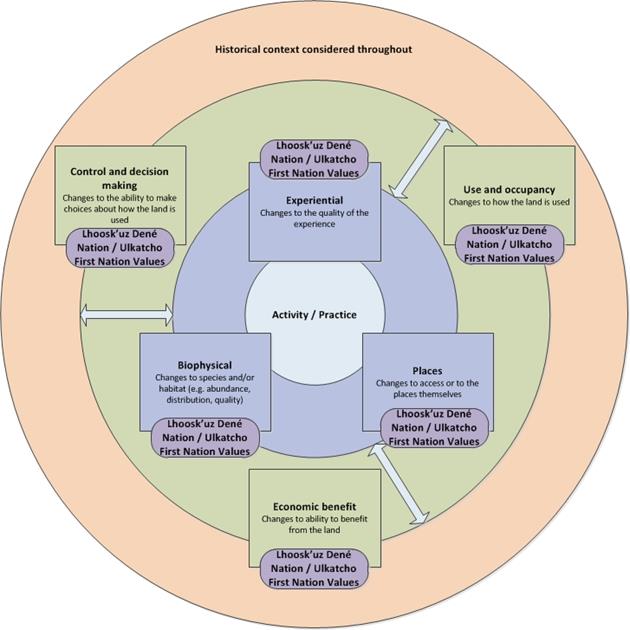
Source: The Agency
At the time of report writing, Ulkatcho First Nation, Lhoosk'uz Dené Nation, the Agency, and B.C.'s Environmental Assessment Office continue to assess the severity of each impact and will utilize a framework that assesses a variety of factors: extent, duration/frequency/reversibility, cultural integrity, regional/historic/cumulative effects, governance/nationhood, and impact inequity. Following this, the four parties will continue to discuss mitigation measures and potential conditions to eliminate, minimize, or reduce the potential impacts of the Project on Ulkatcho First Nation and Lhoosk'uz Dené Nation. The four parties will work together to determine a collaborative conclusion on the impacts of the Project on activities or practices based on an assessment of impacts to the related health values. Where collaborative conclusions cannot be made, the differing views of the four parties will be clearly articulated.
8.1.3 Analysis
The potential impacts on Ulkatcho First Nation and Lhoosk'uz Dené Nation health values are both actual and perceived, as varying opinions exist as to whether or not the proponent's mitigation measures will be sufficient to ensure the lasting health of the land, water, wildlife and people within traditional territories. Despite these proposed mitigation measures, community members remain concerned that the damage will extend beyond the physical environment, as the land, water and wildlife are so closely tied to the health of people and culture. Each of the community health values is interconnected, and as a result, an impact to one value results in resounding impacts throughout each of the values. For example, potential (actual and/or perceived) impacts to water include contamination, loss of access to traditional and current fishing areas, loss of access to healthy fish and waterfowl populations for harvesting, loss of use of traditional family keyoh lands, and so forth.
The proponent has proposed a number of mitigation measures for the potential impacts to the health values; however, the communities feel there is much work to be done to protect the health of these values for generations to come. Because community members maintain persistent fears regarding the Project and its impacts to their health values, Ulkatcho First Nation and Lhoosk'uz Dené Nation were unable to determine the severity of the impacts, even with consideration of the proponent's proposed mitigation measures. As such, Ulkatcho First Nation and Lhoosk'uz Dené Nation have recently identified additional mitigation measures for future discussions with the proponent, the Agency, and B.C.'s Environmental Assessment Office.
8.1.4 Next steps
Ulkatcho First Nation and Lhoosk'uz Dené Nation would like to see further meaningful and in-depth conversations about the proposed mitigation measures, including both those proposed by the proponent, and by Ulkatcho First Nation and Lhoosk'uz Dené Nation, followed by collaborative condition development with the Agency and B.C.'s Environmental Assessment Office, including discussion of the Agency's proposed EA conditions. Once complete, all parties will be better equipped to fully conclude on the severity of the Project impacts to the health values of Ulkatcho First Nation and Lhoosk'uz Dené Nation. If collaborative conclusions cannot be made, the differing views of the four parties will be clearly articulated.
8.2 Summary of Collaborative Assessment with Nadleh Whut'en First Nation, Saik'uz First Nation and Stellat'en First Nation (the Carrier Sekani First Nations)
The following is a summary of the preliminary document provided to the Agency by the Carrier Sekani First Nations. The preliminary document provides the Carrier Sekani First Nations' perspectives on how the Project may impact their Aboriginal rights and uses a methodology that was developed by the Carrier Sekani First Nations.
8.2.1 Purpose
The Carrier Sekani First Nations, including Nadleh Whut'en First Nation, Saik'uz First Nation, and Stellat'en First Nation (collectively referred to as the Carrier Sekani First Nations), the Agency, and B.C.'s Environmental Assessment Office worked collaboratively to review the EIS for the Project. The collaborative approach to the EA was informed, in part, by the existing government-to-government agreements between the Carrier Sekani First Nations and B.C., the EA Collaboration Plan, and the Agency's Consultation Work Plan.
The preliminary Carrier Sekani First Nations document considers (1) the Project's potential impacts on the Aboriginal rights, title, and interests of the Carrier Sekani First Nations, (2) associated consultation and accommodation processes and outcomes; and (3) discusses the potential effects and impacts of the Project relative to the potential benefits that the Project may generate.
8.2.2 The Project and the Carrier Sekani First Nations
Critical infrastructure necessary for the Project—including the proposed transmission line and the Kluskus Forest Service Road—would be located within the Carrier Sekani First Nations' traditional territories, should the Project proceed.
The Carrier Sekani First Nations are all part of the Dakelh or Yinka Dene Nation. These names, Dakelh ("travelers on water") and Yinka Dene ("people of the earth"), reflect key aspects of each of the Carrier Sekani First Nations' identities. The Carrier Sekani First Nations are also commonly referred to as Carrier, thought to be a translation of a Sekani term for their people.
Saik'uz First Nation is a Dakelh community located a short distance from the geographical centre of B.C. The name Saik'uz is derived from the Dakelh (Carrier) word meaning "on the sand," and refers to the sandy soil upon which the main community is located. Saik'uz First Nation was, and continues to be, self-governing. Saik'uz First Nation's hereditary governance is based on clans and keyohs. Saik'uz First Nation members are divided into two clans: the Nulki Whut'en, (the frog clan) and the Ta'chik Whut'en (the grouse clan). In addition to the hereditary governance system, Saik'uz First Nation also has an elected political governing structure in place.
Nadleh Whut'en is a First Nation of the Dakelh people. Nadleh Whut'en First Nation is located between Nadleh Bun (Fraser Lake) and the Nechako River, along the banks of the Nautley River, which, at only 800 metres long, is one of the shortest rivers in the world. Nadleh refers to where the salmon return every year, while whut'en refers to where one comes from. Nahleh Whut'en First Nation was and continues to be self-governing. Nadleh Whut'en First Nation hereditary governance is based on clans and keyahs. Nadleh Whut'en First Nation's traditional or ‘hereditary' clan-based governance system is practiced through the bah'lats (often anglicized to "potlatch"). In addition to the hereditary governance system, Nadleh Whut'en First Nation also has an elected political governing structure in place.
Stellat'en are Dakelh speaking peoples, part of the Athapaskan language family. Stellat'en First Nation's traditional territory is in central B.C. and extends from Fort Fraser in the east, to the western shores of Francois Lake, as far north as Grassham Lake and as far south as Knewstubb Lake. When Stellat'en speak of their traditional territory, they speak of Keyoh Whut'en, an area much larger than the Stellaquo reserve. Many parts of the Keyoh Whut'en area are shared with other First Nations, primarily Nadleh Whut'en First Nation, whose reserve is situated on the east end of Fraser Lake. Stellat'en First Nation was and continues to be self-governing. Stellat'en First Nation has both a hereditary and a band council governance system. The traditional, hereditary governance system is matrilineal and clan based. As a matrilineal society, kinship lines are traced through the mother's lineage, and clans and names are inherited through the mother. Stellat'en First Nation is grouped into four clans: grizzly bear/black bear/wolf (dumdenyoo), beaver/owl (tsayoo/tsumusyoo), frog/crane (dulth ts'eyoo), and caribou/little man (luksilyoo).
The Carrier Sekani First Nations have been governing their traditional territories in accordance with the Yinka Dene legal tradition for thousands of years. There are several distinct elements of their governance system and legal tradition. In particular, their peoples are affiliated with various clans that include hereditary leaders known as ‘uza'hne.
The Carrier Sekani First Nations have identified that they each possess Aboriginal rights, title, and interests within and throughout their respective traditional territories, including Aboriginal title to the land, waters, air shed, and the river and lakebed areas. The Carrier Sekani First Nations have also identified that they each hold important Aboriginal rights, title, and interests which include governance, cultural, spiritual, and harvesting rights.
The Carrier Sekani First Nations' view is that Aboriginal title carries with it the right to possess their traditional territories and exclusively occupy, use, and control them for their Nations' and their members' benefit. Aboriginal title also includes incidental rights to: (i) exercise authority and jurisdiction over, (ii) decide on current and future uses, and (iii) actively use and manage each of their traditional territories, including the water, land, air, and resources therein, in accordance with their Nations' laws, customs, and practices.
In April, 2016 Stellat'en First Nation and Nadleh Whut'en First Nation signed the Yinka Dene ‘Uza'hne Surface Water Management Policy enacting a water management regime for the regulation of surface waters in their territories. On July 22, 2016 Saik'uz First Nation adopted this same policy for the protection of water within its traditional territory.
8.2.3 Assessment of Project impacts on the Carrier Sekani First Nations rights, title, and interests
The Carrier Sekani First Nations have each identified Aboriginal rights, title, and interests that will be adversely impacted by the Project. These Aboriginal rights, title, and interests are described individually in the Carrier Sekani First Nations' preliminary document. However, they are often closely tied to one another, with impacts on one right potentially having wide-ranging impacts on others.
The following concerns and issues related to the Project's environmental components, and Aboriginal rights, title, and interests, were raised by the Carrier Sekani First Nations:
- water, including water management, quality and quantity;
- water crossings, wetlands and wildlife habitat, including habitat fragmentation;
- sediment and erosion control;
- hunting, fishing, trapping, and gathering rights, including impacts to the species (e.g. Southern mountain caribou, moose, plants, berries), and methods of harvesting (e.g. traplines);
- use and management of traditional territory;
- socio-economic well-being;
- tailings management;
- access roads;
- opportunities to be involved in the Project throughout the mine life;
- project design, proposed mine facilities, and structures;
- transmission line design and route;
- proposed mitigation measures and conditions;
- cumulative effects; and
- loss of land use due to the transmission line.
The Carrier Sekani First Nations considered the potential impacts of the Project before and after the re-alignment of the transmission line. The re-alignment of the transmission line with the Carrier Sekani First Nations' guidance was indicative of their collaborative relationship with the proponent. The changes to the transmission line reflect the interests of the Carrier Sekani First Nations and provide some mitigation for impacts to specific matters of concern (e.g. minimizing the adverse effects of additional disturbance and fragmentation within an already highly altered landscape, avoiding important areas). However, the environmental effects and impacts on the Carrier Sekani First Nations' rights, title, and interests from the re-aligned transmission line route cannot be fully mitigated, and the Project has the potential to cause adverse effects to the lands, water, air, and resources in the Carrier Sekani First Nations' traditional territories with corresponding adverse impacts to rights, title and interests. Alterations of the project, including the re-alignment of the transmission line, do not eliminate residual effects, and impacts remain characterized as "serious". Accommodation and compensation are required.
When considering the potential impacts of land and resource use decisions on the Carrier Sekani First Nations' rights, title, and interests, the current state of affairs provides the context through which the seriousness of impacts was assessed, based on the degree to which the ability to exercise the right within their traditional territories is constrained.
The Carrier Sekani First Nations have assessed their rights, title, and interests within their traditional territories to be highly constrained and therefore "sensitive" to any effects that incrementally contribute to factors linked to causation (e.g. cumulative environmental effects), and as such, additional impacts are likely to be characterized on the "serious" end of the spectrum. In order for a project to be supported by the Carrier Sekani First Nations within this context, the full suite of accommodation measures, including impact avoidance, mitigation, offsetting and compensation measures, must be implemented. This context also infers that impact avoidance and mitigation measures may dampen adverse effects, but remaining residual effects may still be incremental to causation factors that have exceeded significance and/or high risk thresholds, and therefore impacts may still be characterized as serious.
8.2.4 Proposed mitigation, accommodation and compensation measures
The Carrier Sekani First Nations are presently pursuing accommodative-agreements with the proponent and B.C. in relation to the Project, and hope to pursue accommodative-agreements with Canada. The Carrier Sekani First Nations are looking to take an innovative approach to the issue of accommodation given that the proposed transmission line and the Kluskus Forest Service Road are located within their traditional territories. The Carrier Sekani First Nations have brought forward a suggested list of economic and stewardship accommodation they would like to discuss with B.C. and Canada, which do not preclude any other forms of potential accommodation. This list was provided to B.C. as early as August 31, 2017.
8.2.5 Next steps
The Carrier Sekani First Nations, the Agency, and B.C.'s Environmental Assessment Office are engaged in an ongoing process to collaboratively develop the proposed federal and provincial conditions for the Project, should a provincial EA Certificate and a positive federal EA decision be obtained. The Carrier Sekani First Nations are presently pursuing accommodative-agreements with the proponent and B.C. in relation to the Project. During the public comment period, the Agency will engage with the Carrier Sekani First Nations on the potential environmental assessment conditions for the Project. Final conditions would become legally-binding on the proponent if the Project is allowed to proceed. This draft summary document may be updated to reflect the parties' discussions on the terms and conditions for the Project, once completed.
The Carrier Sekani First Nations are presently pursuing accommodative-agreements with the proponent and B.C. in relation to the Project, and hope to pursue accommodative-agreements with Canada. As these collaborative discussions progress, all parties will be better equipped to fully conclude on the severity of the Project impacts on the rights, title, and interests of the Carrier Sekani First Nations, and the corresponding mitigation and accommodation measures. At this time, the preliminary document would be updated to include the collaborative conclusions of the Carrier Sekani First Nations, the Agency and EAO. If collaborative conclusions cannot be made, the differing views of the three parties will be clearly articulated.
8.3 Agency Views
The Agency would like to acknowledge the efforts and contributions of Lhoosk'uz Dené Nation and Ulkatcho First Nation, and the Carrier Sekani First Nations throughout the EA. At the time of writing this report, the Agency continues to work collaboratively with these Indigenous groups to assess the impacts of the Project on the Aboriginal rights of Lhoosk'uz Dené Nation and Ulkatcho First Nation, and the Carrier Sekani First Nations. As discussions regarding potential conditions progress, each respective collaboration group will continue to work together to reach consensus conclusions regarding the severity of impacts on the Aboriginal rights of Lhoosk'uz Dené Nation and Ulkatcho First Nation, and the Carrier Sekani First Nations.
9 Impacts on Aboriginal Rights
9.1 Aboriginal Rights in the Project Area
The Constitution Act, 1982 recognizes and affirms existing Aboriginal and treaty rights. For the purposes of the EA, the Agency assessed the potential impacts of the Project on Aboriginal rights as articulated either by the Indigenous group directly, or from other information available to the Agency. The EA is not a rights determination process, and the information received from Indigenous groups has been taken at face value for the purposes of understanding the potential interactions between the Project and the area over which groups may exercise Aboriginal rights.
In addition to the collaborative assessments summarized in Section 8 of this report, the Agency also identified the following Indigenous groups for consultation based on the location of the Project and the extent of its potential to cause adverse impacts on Aboriginal rights: Nazko First Nation, Skin Tyee Nation, Ts^ilhqot'in Nation, Métis Nation British Columbia, and Nee-Tahi-Buhn Band. Based on the Haida consultation spectrum, all of these groups were consulted at a low depth, except Nazko First Nation, who was consulted at a moderate depth.
The Agency has concluded that the impact of the Project on the Aboriginal rights and title of Nazko First Nation, Skin Tyee Nation, Ts^ilhqot'in Nation, Métis Nation British Columbia, and Nee-Tahi-Buhn Band would be negligible to low.
9.1.1 Indigenous groups in the Project area
Nazko First Nation
Nazko First Nation's traditional territory consists of land between the southern edge of Stuart River Park in the north and the southern edge of Nazko Lake Park in the south. The territory also covers land between the eastern half of Kluskoil Lake Park in the west and the outskirts of the City of Quesnel in the east.
The proposed mine site is approximately 20 kilometres to the west of Nazko First Nation's traditional territory. The Kluskus Forest Service Road passes through the western portion of Nazko First Nation's traditional territory and the proposed transmission line corridor is just west of the western edge of their traditional territory. The Big Bend re-route option, which is one of three potential transmission line re-routes, would overlap with Nazko First Nation's traditional territory for approximately five kilometres.
Skin Tyee Nation
Skin Tyee Nation's traditional territory comprises land between the southern outskirts of the town of Houston in the north, and Tsacha Lake in the south. Their traditional territory also consists of land between the Burnie River Protected Area and the Atna River Park areas in the west and the southern outskirts of the city of Vanderhoof in the east.
The proposed mine site, portions of the transmission line corridor, the mine access road, and portions of the existing Kluskus and Kluskus-Ootsa Forest Service Roads covers 0.11 percent of Skin Tyee Nation's traditional territory.
Ts^ilhqot'in Nation
Ts^ilhqot'in Nation is comprised of Xeni-Gwet'in First Nations Government, Tl'etinqox Government, Ts^i Deldel First Nation, ?Esdilagh First Nation, Yunesit'in Government, and Tl'esqox Band. Ts^ilhqot'in Nation's traditional territory encompasses land north of the city of Quesnel and the Blackwater River in the north to the southern outskirts of the municipality of Lillooet in the south. Ts^ilhqot'in Nation's traditional territory also comprises land between the Bella Coola River in the west and Clearwater Lake in the east. Ts^ilhqot'in Nation title lands are found within the Xeni-Gwet'in (southwest) portion of the larger territory as described in Ts^ilhqot'in Nation v. British Columbia (2014 SCC 44). The Nenqay Deni Accord between the Government of B.C. and Ts^ilhqot'in Nation sets out ‘Category A' lands, which are under the ownership, control, and management of the Ts^ilhqot'in Nation, and ‘Category B' lands, which is the remaining area in the traditional territory except for the title lands, ‘Category A' lands, and Indian Reserves.
The proposed mine site, portions of the transmission line corridor, the mine access road, and portions of the existing Kluskus-Ootsa Forest Service Roads all fall within the northwest corner of Ts^ilhqot'in Nation's traditional territory, but not within their title lands, or ‘Category A' lands.
Métis Nation British Columbia
Métis Nation British Columbia is an organization that represents 37 Métis chartered communities in the province. Métis Nation British Columbia is one of the five governing members of the Métis National Council and is recognized by the federal government as a representative of Métis interests and Aboriginal rights in B.C. In contrast to other Indigenous groups, Métis Nation British Columbia has not identified Aboriginal rights and title over specific areas in the province. Instead, Métis Nation British Columbia has identified Aboriginal rights and traditional uses throughout B.C. on behalf of their members.
Based on information provided by Métis Nation British Columbia, Métis citizens who are residing in chartered communities in proximity to the proposed mine site are continuing to exercise various Aboriginal rights such as hunting, fishing, trapping, and gathering throughout the Project area.
Nee-Tahi-Buhn Band
Nee-Tahi-Buhn Band's traditional territory comprises land between the communities of Burns Lake and Topley in the north, and Eutsuk and Tetachuck Lakes in the south. The traditional territory also consists of land between Hanging Mountain in the west, and the community of Fort Fraser in the east.
A portion of the proposed new alignment of the transmission line and the Stellako re-route both fall within the northeastern corner of Nee-Tahi-Buhn Band's traditional territory.
9.2 Potential Adverse Impacts of the Project on Aboriginal Rights
9.2.1 Proponent's assessment
The proponent provided its assessment of the impacts of the Project on the exercise of each Indigenous group's Aboriginal rights. For this analysis, the proponent relied on information collected directly from Indigenous groups and publically available information to ascertain potential impacts and identify mitigation and accommodation measures. The proponent selected the following to assess as Aboriginal rights: hunting, trapping, fishing, plant harvesting, cultural continuity, access and occupation, and title. For the evaluation of title, the proponent considered the ability of the Indigenous group to make land use decisions.
Nazko First Nation
For Nazko First Nation, the proponent stated that the Kluskus Forest Service Road is an existing feature of the landscape, and because the Big Bend re-route option would parallel the Kluskus Forest Service Road, the change to Nazko First Nation's territory would be minor. As small portions of the existing Kluskus Forest Service Road overlap with Nazko First Nation's traditional territory, changes to the quantity of wildlife available for harvesting due to mortality associated with vehicle collisions would be minor.
The proponent did not predict changes to Nazko First Nation's Aboriginal right to fish or trap. Additionally, the proponent stated that changes to the quality of plants due to dust generated by traffic using the Kluskus Forest Service Road would be minor. The proponent did not predict changes to Nazko First Nation's cultural continuity, access and occupation, or title. The proponent stated that all changes to Nazko First Nation's traditional territory could be fully mitigated and concluded that the Project would have no impact on the group's Aboriginal right to hunt, trap, fish, harvest plants, cultural continuity, access and occupation, and title.
Skin Tyee Nation
For Skin Tyee Nation, whose traditional territory subsumes the majority of the Project's footprint and associated activities, the proponent stated that the ability of their members to hunt could be moderately impacted due to a decrease in the quantity of species, particularly in areas surrounding the mine site and adjacent to the Kluskus and Kluskus-Ootsa Forest Service Roads. The proponent concluded that there would be no impact on the Aboriginal right to trap furbearers.
The proponent stated that the Aboriginal right to fish for Skin Tyee Nation would not be impacted given the number of other waterbodies outside of the Project's footprint, but within the traditional territory that Skin Tyee Nation could continue to use for fishing.
The proponent concluded that the Project would not have an impact on the Aboriginal plant harvesting or gathering right of Skin Tyee Nation because no information was provided from the group on this practice.
Skin Tyee Nation raised concerns about the Project's potential disturbance to sense of place as an indicator of impacts to cultural continuity. The proponent found that there would be a moderate impact to their Aboriginal right to sense of place and cultural continuity as a result of local auditory and visual disturbances to the practice of rights within the vicinity of the airstrip, the Kluskus and Kluskus-Ootsa Forest Service Roads, the transmission line corridor, and the mine site. The effects would be reversible in post-closure.
The proponent stated that while the access and use of various trails by members would likely be impacted by the construction of the transmission line and freshwater supply system, the overall impact to the Aboriginal right to access and occupy Skin Tyee Nation's traditional territory would be low because impacts would be temporary (two years).
The proponent predicted a moderate impact on the Aboriginal title of Skin Tyee Nation because the Project is anticipated to diminish or disrupt the group's ability to choose how the land will be used.
Overall, the proponent concluded that the Project would have a negligible to moderate impact on the Aboriginal rights of Skin Tyee Nation.
Ts^ilhqot'in Nation
The proponent noted Ts^ilhqot'in Nation's concerns about moose and Southern mountain caribou harvesting, and concluded that the Project would have a low impact on their ability to hunt due to a small decrease in the quantity of species in areas adjacent to the Kluskus-Ootsa Forest Service Road. The proponent suggested that the impact will be reversible and would only affect a small portion of Ts^ilhqot'in Nation's territory. The proponent concluded that there would be no impact on the Aboriginal right to trap furbearers.
The proponent noted Ts^ilhqot'in Nation did not provide specific information about their fishing and plant harvesting practices. The proponent concluded that the Project would have no impact on Ts^ilhqot'in Nation's fishing and plant harvesting rights because the residual adverse effects to fish and fish habitat from the Project would not be significant. The proponent also concluded that the Project would not have an impact on the Aboriginal plant harvesting or gathering rights of Ts^ilhqot'in Nation.
Ts^ilhqot'in Nation raised concerns about the Project's potential disturbance to sense of place. The proponent found that there would be some impact to their sense of place, which was considered an indicator for impacts to cultural continuity, as a result of auditory and visual disturbances, but the impact would be in the vicinity of the airstrip, the Kluskus-Ootsa Forest Service Road, the transmission line corridor, and the mine site, and would be reversible in post-closure. The proponent concluded the impact on Ts^ilhqot'in Nation's Aboriginal right to cultural continuity to be moderate.
The proponent noted that it was not informed of how Ts^ilhqot'in Nation access their traditional territory in the area of the Project. However, the proponent anticipated that the Project's impact on Ts^ilhqot'in Nation's right to access and occupy its traditional territory would be low because any disruption to Ts^ilhqot'in Nation members use of trails to access its territory would be short term (two years).
The proponent noted that the Project falls outside of Ts^ilhqot'in Nation title lands. While the Project area may fall within Ts^ilhqot'in Nation's traditional territory, the Project is not expected to diminish or disrupt the group's ability to choose how the land will be used. As such, the proponent concluded the Project would have a low impact on the Aboriginal title of Ts^ilhqot'in Nation.
Overall, the proponent concluded that the Project would have a low to moderate impact on the Aboriginal rights of Ts^ilhqot'in Nation.
Métis Nation British Columbia
The proponent did not receive information from Métis Nation British Columbia specifically about their Aboriginal right to hunt, trap, fish, harvest plants, cultural continuity, or access and occupation in relation to the local or regional study areas associated with the Project, and concluded that it did not anticipate impacts to Métis Nation British Columbia.
Métis Nation British Columbia also did not identify Aboriginal title in the project area; however, the proponent evaluated the potential impact on Métis Nation British Columbia. The proponent concluded that the Project would not have an impact on the Aboriginal title of Métis Nation British Columbia.
Overall, the proponent concluded that it did not anticipate that the Project would have adverse impacts on the Aboriginal rights of the members represented by Métis Nation British Columbia.
Nee-Tahi-Buhn Band
The proponent did not receive information from Nee-Tahi-Buhn Band specific to their Aboriginal rights to hunt, trap, fish, harvest plants, cultural continuity, access and occupation, or title in relation to the Project, and therefore concluded it did not anticipate that the Project would have adverse impacts on the Aboriginal rights of Nee-Tahi-Buhn Band.
9.2.2 Indigenous views
Nazko First Nation, Skin Tyee Nation, Ts^ilhqot'in Nation, Métis Nation British Columbia and Nee-Tahi-Buhn Band expressed that the Project would have adverse impacts on their Aboriginal rights to hunt, trap, and fish in their traditional territories and access to their traditional sites. These groups also provided feedback on the Project's potentially adverse effects on Aboriginal title, with the exception of Métis Nation British Columbia.
Nazko First Nation
Nazko First Nation provided their views on the impact of the Project on their Aboriginal rights, interests, and title through correspondence with the Agency. Nazko First Nation stated that the Project would result in increased traffic on the Kluskus Forest Service Road, which would affect the ability of their members to hunt moose; the increased traffic would increase the potential for vehicle collisions with moose and cause changes to movement patterns and the availability of moose. Nazko First Nation stated that the higher possibility of spills of dangerous goods along the Kluskus Forest Service Road and the construction of the proposed transmission line could have an impact on habitat and water quality, which could in turn affect the number of fish that are available to catch in Nazko First Nation's traditional territory and could thus negatively impact their fishing rights, especially for species they rely on such as Lake trout, Coho and Sockeye salmon. Nazko First Nation stated that the mine site would further reduce populations of moose, Southern mountain caribou and Grizzly bear, which would thus inhibit the ability to practice their Aboriginal hunting rights. To help mitigate the potential impacts to their Aboriginal rights, in addition to the mitigation measures proposed by the proponent, Nazko First Nation recommended that they should be involved in the development and implementation of management plans and monitoring initiatives with the proponent, including the Wildlife Management Plan, the Transportation and Access Management Plan, and the Emergency and Spill Preparedness and Response Plan. Additionally, Nazko First Nation noted that, should the project proceed, they would be seeking employment and training opportunities, and business opportunities and contracts in collaboration with the proponent.
Skin Tyee Nation
Skin Tyee Nation did not provide comments on the potential impacts of the Project on their Aboriginal rights to the Agency.
Ts^ilhqot'in Nation
Ts^ilhqot'in Nation provided their views to the Agency on the impact of the Project on their Aboriginal rights, interests, and title following the proponent's completion of the EIS. Ts^ilhqot'in Nation expressed concern about the potential impact that the Project would have on their ability to hunt Southern mountain caribou and moose. In particular, Ts^ilhqot'in Nation expressed their desire to participate in working group meetings about Southern mountain caribou to discuss monitoring, mitigation, and compensation measures. Furthermore, Ts^ilhqot'in Nation also expressed a concern about the ability of their members to obtain economic benefits from the Project.
Métis Nation British Columbia
Métis Nation British Columbia expressed that the mitigation measures discussed by the proponent in the EIS were well designed with respect to fishing and hunting. However, Métis Nation British Columbia raised concerns that Northern goshawk, a species of interest for hunting, is declining in the project area and mitigation measures in the EIS for the species were lacking. The proponent clarified that the species detected in the project area was the atricapillus subspecies of Northern goshawk, which is not considered to be at risk, and although not a migratory bird, mitigation measures for migratory birds would help reduce potential effects to Northern goshawk.
Nee-Tahi-Buhn Band
Nee-Tahi-Buhn Band stated that the Project would have an impact on a "Grease Trail" they have used historically for trade and commerce. Nee-Tahi-Buhn Band also stated that they would be gathering more information about their historical use of the land in the area of the Grease Trail and would submit an amended map. However, at the time of writing this report Nee-Tahi-Buhn Band has not provided this information to the Agency, nor have they provided further information about how the Project would affect their Aboriginal rights, title and interests.
9.2.3 Agency views
A pathway is the route a project-related impact takes to reach the exercise of an Aboriginal right and provides a systematic approach for linking a project and its activities to possible impacts on rights. To evaluate the potential impacts of the Project on the Aboriginal rights of Nazko First Nation, Skin Tyee Nation, Ts^ilhqot'in Nation, Métis Nation British Columbia and Nee-Tahi-Buhn Band, the Agency used a pathway approach that examined the changes the Project could cause to the quality or quantity of a resource, sensory/experience of practicing an Aboriginal right, and access, which could impact the ability of a group to successfully practice an Aboriginal right. The approach varies from the one taken by the proponent. For example, where the proponent chose to evaluate impacts on access as a right, the Agency used changes to access as a pathway to evaluate impacts to hunting, trapping, fishing and gathering. To understand potential impacts to Aboriginal title, the Agency considered impacts to cultural continuity, access, and the Indigenous groups' ability to make land use decisions.
In evaluating the severity of impact to Aboriginal rights, the Agency used a framework that assessed a variety of factors: extent, likelihood, duration/frequency/reversibility, cultural integrity, regional/historic/cumulative effects, stewardship/nationhood, impact inequity, and mitigation/accommodation measures. Using this framework, the Agency reached its views on a scale of negligible-low-moderate-high impact on an Aboriginal right.
Nazko First Nation
Nazko First Nation provided information to the Agency regarding the potential impacts to their hunting, trapping and fishing rights from the use of the Kluskus Forest Service Road and the proposed Big Bend re-route of the transmission line. If this re-route is chosen, the Agency is of the view that Nazko First Nation will likely experience low impacts to their hunting, trapping, gathering and fishing rights due to a potential decrease in the quantity of species available for harvesting, increased wildlife disturbance, and a potential increase in motor vehicle accidents involving wildlife. Nazko First Nation did not provide any information on specific fishing sites that lie within the re-route option. The Agency is of the view that the proponent's mitigation measures for dust to address effects of increased traffic along the Kluskus Forest Service Road will result in a low impact on Nazko First Nation's plant gathering rights.
Nazko First Nation would experience visual and auditory disturbances while practicing rights in their traditional territory, including increased noise, artificial light, and dust from the operation of construction equipment, the freshwater supply system, tailing storage facility, and airstrip, and increased traffic along the Kluskus Forest Service Road. The creation of additional access by the Project to areas that were not previously accessible, or where there was limited accessibility, could result in increased competition for wildlife resources from non-Indigenous hunters. Additionally, if the Big Bend re-route is selected there would be an increase in noise from equipment, traffic, and workers during construction of the transmission line, followed by periodic noise during operations, closure, and post-closure due to ongoing maintenance and minor operational and weather-dependant occurrences. These disturbances could result in decreased hunting, trapping, and gathering success. Mitigation measures proposed by the proponent such as dust suppression, policies for workers to prevent hunting and trapping, and the establishment of an access management working group will minimize experiential and access impacts to Nazko First Nation's practice of rights.
The Agency has concluded that if the Big Bend re-route is selected for the transmission line there will be a low impact on Nazko First Nation's Aboriginal title due to loss of cultural continuity due to the potential loss of areas of cultural importance, and the loss of ability to make land use decisions. If a different transmission line alignment is selected, the Project will have a negligible impact on Nazko First Nation's Aboriginal title.
Skin Tyee Nation
The Agency based its analysis on Crown constructive knowledge and information provided by the proponent, but received no information from Skin Tyee Nation regarding areas of preferred use or how the project would impact their practice of rights at or around the mine site or linear components.
Skin Tyee Nation would likely experience impacts to their hunting and trapping rights because their land base will be potentially reduced. Specifically, the Skin Tyee Nation may experience negative impacts to their hunting and trapping rights in the areas adjacent to the mine site, Kluskus and Kluskus-Ootsa Forest Service Roads, mine access road, and the transmission line corridor as a result of a decrease in the quantity of species available for harvesting due to increased wildlife disturbance and an increase in motor vehicle accidents involving wildlife.
The Agency has considered the proponent's analysis of the Skin Tyee Nation's traditional land use study and holds the view that an adverse impact to Skin Tyee Nation's fishing rights is likely to be low because none of the group's fishing sites overlap with project components.
For Skin Tyee Nation, the Agency has noted in the proponent's assessment that the quality and quantity of some berry and medicinal plant gathering sites may be impacted by land clearing associated with the constructions of the freshwater supply system. However, berries and medicinal plants are available in other areas of Skin Tyee Nation's traditional territory. Consequently, the Agency is of the view that the adverse impacts to plant gathering rights for Skin Tyee Nation are likely to be low.
Skin Tyee Nation would experience visual and auditory disturbances from the operation of construction equipment, the freshwater supply system, the tailing storage facility, and the airstrip while practicing rights in their traditional territory. Mitigation measures proposed by the proponent such as dust suppression, policies for workers to prevent hunting and trapping, and the establishment of an access management working group will minimize experiential and access impacts to Skin Tyee Nation's practice of rights.
The Agency considers that the Project's impacts to Skin Tyee Nation's Aboriginal title, including the ability to make land use decisions and cultural continuity, will likely be low. Skin Tyee Nation would not be able to make land use decisions around the mine site during the construction, operation, and decommissioning of the mine.
Based on the mitigation measures proposed by the proponent, the Agency is of the view that the impacts on Skin Tyee Nation's Aboriginal rights from the Project are likely to be low.
Ts^ilhqot'in Nation, Métis Nation British Columbia, and Nee-Tahi-Buhn Band
The Agency has not received specific information through consultation from Ts^ilhqot'in Nation, Métis Nation British Columbia, and Nee-Tahi-Buhn Band about how the Project will impact these groups' hunting, trapping, gathering and fishing rights. Based on the information provided by the proponent about the Project's potential impacts on hunting and trapping, and the proposed mitigation measures, the Agency is of the view that the Project will have a negligible-to-low impact on the hunting, trapping, gathering and fishing rights of Ts^ilhqot'in Nation, Métis Nation British Columbia, and Nee-Tahi-Buhn Band.
For Ts^ilhqot'in Nation, the Agency is of the view that the Project's impacts to the group's Aboriginal title will likely be low. The mine site is outside of Ts^ilhqot'in Nation's Aboriginal title lands and ‘Category A' lands.
Nee-Tahi-Buhn Band did not provide information to the Agency regarding the potential impacts of the Project on their Aboriginal title. Given the limited information that was provided by the proponent, and what is publically available, the Agency concludes that the Project will have a negligible impact on the Aboriginal title of Nee-Tahi-Buhn Band.
Métis Nation British Columbia did not identify Aboriginal title in the project area on behalf of their members.
9.3 Proposed Mitigation and Accommodation Measures
Following concerns expressed by Indigenous groups about the impact of the Project's transmission line on Aboriginal rights and title, the proponent proposed to re-align the transmission line.
The proponent concluded that the proposed new transmission line options would decrease the potential impacts on Aboriginal rights and title for Skin Tyee Nation and Ts^ilhqot'in Nation. The proponent acknowledged that only one of the three proposed re-route options would cross into Nazko First Nation's traditional territory, but the proponent concluded that the potential impact of any transmission line alignment would be negligible on Nazko First Nation's Aboriginal rights and title. The proponent did not provide the impact of the proposed new alignment of the transmission line with respect to the Aboriginal rights and title of Métis Nation British Columbia because it did not receive any information as to how the proposed new alignment would affect the Métis Nation British Columbia's rights and interests. The proponent also removed the east waste rock dump and related infrastructure to minimize the mine site footprint, and added an additional water treatment plant to maximize recycling water on-site to minimize effects to Tatelkuz Lake, which would reduce potential impacts on Aboriginal rights and title for Skin Tyee Nation.
The mitigation measures identified by the proponent to address potential impacts on Aboriginal rights are listed under Section 6.8 of this report. A list of key mitigation measures identified by the Agency is provided in Appendix C.
9.4 Agency Conclusion Regarding Impacts on Aboriginal Rights
The Agency considered the concerns and input from Nazko First Nation, Skin Tyee Nation, Ts^ilhqot'in Nation, Métis Nation British Columbia, and Nee-Tahi-Buhn Band regarding the impacts of the Project on Aboriginal rights or title, including on the proponent's proposed mitigation and accommodation measures, and comments provided by Indigenous groups so far during the EA.
The Agency is of the view that the impact of the Project on the Aboriginal rights and title of Nazko First Nation, Skin Tyee Nation, Ts^ilhqot'in Nation, Métis Nation British Columbia, and Nee-Tahi-Buhn Band would be negligible to low.
The Agency recognizes that consultation is ongoing and further information regarding potential residual impacts may still be forthcoming. Input from Indigenous groups on the draft EA Report will be considered and will assist the Agency in finalizing its conclusions regarding potential impacts from the Project on Aboriginal rights.
10 Conclusion and Recommendations of the Agency
In preparing the draft EA Report, the Agency took into account the proponent's EIS, its responses to information requests, and the views of government agencies, Indigenous groups, and the public.
The environmental effects of the Project and their significance have been determined using assessment methods and analytical tools that reflect current accepted practices of environmental and socio-economic assessment practitioners, including consideration of potential accidents and malfunctions.
The Agency concludes that, taking into account the implementation of mitigation measures, the Project is not likely to cause significant adverse environmental effects as defined in subsection 5(1) of CEAA 2012.
The Agency also concludes that taking into account the implementation mitigation measures, the Project is not likely to cause other significant adverse environmental effects defined in subsection 5(2) of CEAA 2012.
The Agency has identified key mitigation measures and follow-up program requirements for consideration by the Minister in establishing conditions as part of the Decision Statement, in the event that the Project is permitted to proceed.
11 Appendices
Appendix A Environmental Effects Rating Criteria
|
Rating criteria |
Rating |
|---|---|
|
Relevant to all valued components |
|
|
Frequency |
Once: effects occur on one occasion over the life of the Project Intermittent: effects occur several times over the life of the Project Continuous: effects occur continuously over the life of the Project |
|
Reversibility |
Reversible: effects are reversible over one to a few cycles of the physical event after the impact ceases (physical). Effects are reversible over one to a few life cycles after the impact ceases (biological) Irreversible: effects are not reversible over the above time scales |
|
Duration |
Short-term: effects occur for less than two years Medium-term: effects occur from two to less than 17 years Long-term : effects occur from 17 years to less than 42 years Chronic: effects occur for 42 years or more |
|
Context |
Low: valued component has strong resilience to stress, has not be affected by other projects or activities or natural changes. No listed species or ecosystems identified Moderate: valued component has moderate resilience to stress, has been affected by other projects or activities, or natural changes but still has capacity to assimilate more changes. Presence of blue-listed species or ecosystems High: valued component has weak resilience to stress, has been severely affected by other projects or activities, or natural changes Presence of red-listed or SARA-listed species or ecosystems |
|
Aquatic environment — groundwater quantity |
|
|
Magnitude |
Negligible: no detectable change from baseline conditions Low: some effects are noticeable, however recovery is relatively rapid and the effects result in either 5 to 10 percent change in contribution to surface water flow from baseline conditions or 1 to 10 percent reduction in wetland area from baseline Moderate: effects occur and recovery is not relatively rapid and the effects result in either 10 to 20 percent change in contribution to surface water flow from baseline conditions or 10 to 20 percent reduction in wetland area from baseline High: change in groundwater levels and flows from baseline conditions are permanent and the effects result in either more than 20 percent change in contribution to surface water flow from baseline conditions or more than 20 percent reduction in wetland area from baseline |
|
Geographic extent |
Site-specific: effects occur within the mine site and/or transmission line corridor Local: effects occur within the local study area Regional: effects occur within the regional study area |
|
Aquatic environment — surface water flow |
|
|
Magnitude |
Negligible: effects are not measurable (less than 5 percent change in flow from baseline conditions) Low: 5 to 10 percent change in flow from baseline conditions Moderate: 10 to 20 percent change in flow from baseline conditions High: greater than 20 percent change in flow from baseline conditions |
|
Geographic extent |
Site-specific: effects occur within the mine site and/or transmission line corridor Local: effects occur within the local study area Regional: effects occur within the regional study area |
|
Threshold |
An effect would be considered significant if: a 20 percent change is experienced |
|
Aquatic environment — water quality |
|
|
Magnitude |
Negligible: no detectable change from baseline conditions Low: effects result in conditions that differ from the average value for baseline conditions but remains within the range or natural variation and below a guideline or threshold value Moderate: effects result in conditions that differ substantially from the average value for baseline conditions and may be above the limits of natural variation; indicators may be above the thirty-day average guidelines, but below the maximum guideline (if applicable) High: effects result in conditions that differ substantially from the average value for baseline conditions and indicators may be above the limits of natural variation and above the maximum guideline (or thirty-day average guidelines if no maximum guidelines are applicable) |
|
Geographic extent |
Site-specific: effects occur within the mine site and/or transmission line corridor Local: effects occur within the local study area Regional: effects occur within the regional study area |
|
Threshold |
An effect would be considered significant if: water quality parameters differ substantially from the average value for baseline conditions and indicators may be above the limits of natural variation and above the maximum guideline |
|
Wetlands |
|
|
Magnitude |
Negligible: no detectable change from baseline in wetland extent (less than 1 percent reduction in area from baseline) Low: 1 to 10 percent reduction in wetland area from baseline Moderate: 10 to 20 percent reduction in wetland area from baseline High: greater than 20 percent reduction in wetland area from baseline |
|
Geographic Extent |
Site specific: effects occur within the mine site and/or transmission line corridor Local: effects occur within the local study area Regional: effects occur within the regional study area |
|
Fish and fish habitat |
|
|
Magnitude |
Negligible: no detectable change from baseline Low: effects result in conditions that differ from mean baseline value, but is within range of natural variation, and below guideline or threshold; measurable effect on habitat function is anticipated but on low quality, marginal, or non-critical habitat Moderate: effects result in conditions that differ from mean baseline value, approaches limits of natural variation, but is below or equal to guideline or threshold; measurable effect on habitat function is anticipated on moderate, high quality, or critical habitat High: effects result in conditions that differ from mean baseline value, is outside range of natural variation, and beyond guideline or threshold; measurable effect on habitat function is anticipated on important habitat for provincially-listed species or Species at Risk Act-listed species |
|
Geographic extent |
Site-specific: effects occur within the mine site and/or transmission line corridor Local: effects occur within the local study area Regional: effects occur within the regional study area |
|
Threshold |
An effect would be considered significant if: they differ from mean baseline value, is outside range of natural variation, and beyond guideline or threshold; measurable effect on habitat function is anticipated on important habitat for provincially-listed species or Species at Risk Act-listed species |
|
Migratory birds |
|
|
Magnitude |
Negligible: no measurable effects Low: effects result in a measurable change but within the range of expected natural variation based on species life history Moderate: effects result in a measurable change but less than high High: effects result in a greater than 20 percent change of density, abundance or distribution for listed species and a greater than 30 percent change of density, abundance, or distribution for all other species |
|
Geographic extent |
Site specific: effects occur within the project components' footprint Local: effects occur within the local study area Regional: effects occur within the regional study area |
|
Threshold |
An effect would be considered significant if the residual effects indicate: a greater than 20 percent change in amount of moderate to highly suitable habitats within the regional study area for water birds and forest and grassland birds occurs, with consideration of lack of use or displacement due to sensory disturbance; and considers (for water birds only):
or a 30 percent habitat loss for species not of conservation concern, or 20 percent for those of concern |
|
Wildlife and species at risk |
|
|
Magnitude |
Negligible: no measurable effects Low: effects result in a measurable change but within the range of expected natural variation based on species life history Moderate: effects result in a measurable change but less than high High: effects result in a greater than 20 percent change of density, abundance or distribution for listed species and a greater than 30 percent change of density, abundance, or distribution for all other species |
|
Geographic extent |
Site specific: effects occur within the project components' footprint Local: effects occur within the local study area Regional: effects occur within the regional study area |
|
Threshold |
An effect would be considered significant if the residual effects indicate:
|
|
Health and socio-economic conditions of Indigenous peoples and public socio-economic conditions |
|
|
Magnitude |
Negligible: no measurable effect Low: effects are measurable but do not exceed any established guidelines or thresholds Moderate: effects are clearly distinguishable, may be nearing guidelines or thresholds, will persist with mitigation and management, and may result in elevated concern amongst stakeholders High: effects are highly distinguishable and result in exceedances of guidelines or thresholds, will persist with mitigation and management, and may result in substantial concern amongst stakeholders |
|
Geographic extent |
Site specific: effects occur within the mine site and/or transmission line corridor Local: effects occur within the local study area population Regional: effects occur within the regional study area population |
|
Physical and cultural heritage |
|
|
Magnitude |
Negligible: no measurable effect Low: effects result in a change from baseline conditions, but the feature of physical and/or cultural heritage importance would remain relatively unchanged; and activity associated with the feature and its relative value would not be affected Moderate: effects result in a change from baseline conditions, and the feature of physical and/or cultural heritage importance would be noticeably changed; and activity and use associated with the feature and its value would be affected, but could continue High: the feature of physical and/or cultural heritage importance would be removed, destroyed, and/or use associated with the feature would no longer continue |
|
Geographic extent |
Site specific: effects occur within the mine site and/or transmission line corridor within the local study area Local: effects occur within the local study area Regional: effects occur within the regional study area |
|
Current use of lands and resources for traditional purposes |
|
|
Context |
Low: current use by Indigenous peoples is close to historic levels; little interference with underlying conditions; and/or current use by Indigenous peoples is highly resilient to change Moderate: current use by Indigenous peoples partially diminished from historical levels; moderate interference with underlying conditions; and or current use by Indigenous peoples moderately resilient to change High: current use by Indigenous peoples highly diminished from historical levels; high interference with underlying conditions and / or current use by Indigenous peoples has low resilience to change |
|
Magnitude |
Negligible: no detectible change in use of access routes, quantity and quality of resources, and/or noise or visual quality of experience Low: the magnitude of the effect differs from baseline use conditions, but the activity could be practiced in the same or similar manner as before. For example, access routes continue to be used but with increased delays and/or unsafe conditions, quality and quantity of resources reduced in one harvesting area and/or noise differs from baseline conditions but remains below high annoyance threshold value or visual changes form a minor part of the landscape Moderate: the magnitude of the effect differs from the baseline use conditions and preferred locations and means for practicing the activity may be lost or modified. For example, alternate routes must be used, quality and quantity of resources reduced in several harvesting areas and/or noise levels differ substantially from baseline conditions and equal or slightly exceed high annoyance threshold value or visual changes form a noticeable but not dominant feature of the landscape High: the magnitude of the effect differs from baseline use conditions and the activity can no longer be carried out in the preferred manner and locations. For example, access is completely impeded, harvesting of resources completely unsuccessful and/or noise levels exceed high annoyance threshold or visual changes dominate the landscape |
|
Geographic extent |
Site-specific: effect occurs within a single site Local: effect occurs at multiple sites within the local study area Regional: effect occurs at multiple sites within the local study area and regional study area |
|
Greenhouse gas emissions |
|
|
Magnitude |
Negligible: no measurable effect Low: project emissions represent a small contribution to provincial or national emissions Moderate: project emissions represent a moderate contribution to provincial or national emissions High: project emissions represent a high contribution to provincial or national emissions |
|
Geographic extent |
Site specific: effects occur within the mine site and/or transmission line corridor within the local study area Local: effects extend beyond the activity area but remain within the local study area Regional: effects occur beyond the local study area and mainly within the regional study area Beyond regional: effects extend beyond the regional study area |
Appendix B Summary of Environmental Effects Assessment
|
Predicted residual effects |
Characterization of residual effects |
Conclusion and rationale |
|---|---|---|
|
Aquatic environment |
||
|
Changes in water quantity Change in water table levels, and groundwater and surface water flow regimes, could occur as a result of changes in landscape features through the construction of the open pit, tailings storage facility, site C west dam, and west waste rock dump. Effects to water table level, and groundwater and surface water flows, could occur during construction, operations, closure and post-closure. |
|
Not significant The proponent has committed to pumping water from Tatelkuz Lake and directing inputs from non-contact diversion channels and water treatment plant to maintain stream flows in Davidson Creek to offset reduction in groundwater downstream of the environmental control dam. |
|
Changes in water quality - groundwater seepage and surface discharges Groundwater seepage from the tailings storage facility site D and the open pit/pit lake; and surface water discharges from the freshwater reservoir, sediment control ponds, metals removal water treatment plant, tailings storage facility site D spillway, environmental control dam, and untreated surface runoff, will enter Davidson Creek and Creek 661 and alter water quality in the streams. |
|
Not significant There is some uncertainty regarding the hydrologic analysis and modelling technique, and the effectiveness of drawing water from Tatelkuz Lake for instream flow needs. |
|
Changes in water quality - erosion and sedimentation Construction and closure activities would disturb the ground and increase turbidity and total suspended sediment concentrations in Davidson Creek and Creek 661. |
|
Not significant The proponent has committed to applying sediment and erosion control best management practices and mitigation measures. |
|
Wetlands |
||
|
Loss of extent and wetland functions, and temporarily altered or degraded wetland functions 319.7 hectares of wetlands would be removed during land clearing at the mine site and certain linear components. 123.3 hectares of wetlands would also be temporarily altered due to project activities such as dust deposition and winter road maintenance. Loss and alteration of wetlands would affect ecological, biochemical, and hydrological wetland functions. |
|
Not significant The proponent intends to mitigate for lost wetlands by creating 42.8 hectares of wetlands offsite prior to operations and creating 305 hectares of wetlands at the mine site through progressive reclamation. To address uncertainty regarding the effectiveness of compensated and created wetlands in restoring lost wetland functions, the proponent will implement a follow-up program. |
|
Fish and fish habitat |
||
|
Direct mortality Direct mortality of fish could occur through construction and decommissioning activities and accidental loss or injury during fish salvage. |
|
Not significant The proponent has committed to conducting fish salvages, adhering to best management practices, and implementing Fisheries and Oceans Canada advice to limit loss through impingement and entrainment. |
|
Changes in fish health - changes in surface water quality Surface water discharges and groundwater seepage are predicted to introduce contaminants to Davidson Creek and Creek 661. |
|
Not significant The proponent has committed to treating mine water prior to discharge into the receiving environment, until such a time as the water meets discharge guidelines established by the Metal and Diamond Mining Effluent Regulations and provincial standards. |
|
Changes in fish health - disruption of fish homing in Davidson Creek Flow augmentation to Davidson Creek via the freshwater supply system, which is primarily comprised of water from Tatelkuz Lake, could alter the olfactory environment of the creek and result in the inability of Rainbow trout and Kokanee to locate and spawn in their natal stream. |
|
Not significant The reduction of exclusive reliance on Tatelkuz Lake water and the incorporation of water from the northern and southern diversions from upstream Davidson Creek will reduce the change in water chemistry in Davidson Creek and support homing for fish. |
|
Changes in fish health - changes in water temperature in Davidson Creek Flow augmentation could potentially alter the temperature regime in Davidson Creek which could affect Kokanee embryo development and growth; and Rainbow trout development, growth, and juvenile survival. |
|
Not significant The proponent has designed the freshwater supply system such that temperatures in Davidson Creek track very closely with baseline and the system has the flexibility to meet fish life history requirements for temperature should monitoring show that fish populations are being affected by flow augmentation. |
|
Changes in fish health - mercury mobilization in Lake 01682LNRS The enlargement of Lake 0168LNRS could result in the mobilization of mercury stored in the soil once flooded which could be taken up by aquatic plants and invertebrates, and eventually Rainbow trout. |
|
Not significant Prior to the enlargement of the lake, the proponent has committed to strip the area to be flooded and diversion channel of vegetation and topsoil to reduce the effects of mercury mobilization. |
|
Habitat loss and isolation Fish habitat associated with mine site facilities footprints, downstream flow changes, and upstream habitat isolation will be lost in Davidson Creek and Creek 661. The Project would result in the loss of 30 hectares of instream creek and lake habitat, and 125 hectares of riparian habitat. |
|
Not significant Habitat losses will be offset through the implementation of the Fisheries Mitigation and Offsetting Plan. Fish will be salvaged according to the Fish Salvage Plan. |
|
Habitat loss and isolation -reduction of Littoral Habitat in Tatelkuz Lake To maintain instream flow needs in Davidson Creek, the proponent would augment flows by pumping water to the creek from Tatelkuz Lake through the freshwater supply system. |
|
Not significant The volumes of water required for instream flows will be supplemented with water from the northern and southern diversions and from water treatment plants to minimize the effects to Tatelkuz Lake fish habitat. Littoral habitat in Tatelkuz Lake will be monitored as part of the Aquatic Effects Monitoring Plan. |
|
Change in stream habitat due to changes in stream flow Changes in streamflow are attributed to the development of mine site infrastructure and water withdrawals from Tatelkuz Lake as source water to maintain instream flow needs. This could result in decreased habitat availability and altered behavior, feeding efficiency, and predator detection. |
|
Not significant The proponent has committed to maintain instream flow needs in Davidson Creek through water inputs from the freshwater supply system, northern and southern diversions, and water treatment plant. Any permanent fish habitat losses due to changes in stream flow will be offset through the implementation of the Fisheries Mitigation and Offsetting plan. |
|
Migratory birds |
||
|
Habitat loss and alteration Loss and alteration of migratory bird habitat would occur as a result of activities from the Project during construction, operation and closure, such as: vegetation removal and/or ground disturbance, and the temporal loss of waterbodies and wetlands. Up to 2 019 hectares of habitat is predicted be lost or altered for water birds, and up to 2 735 hectares of habitat is predicted be lost or altered for forest and grassland birds. |
|
Not significant There is some uncertainty regarding the habitat suitability modelling and time lags with respect to wetland habitat function restoration. However, the proponent would carry out the Project in adherence with the Migratory Birds Convention Act (1994)and the Species at Risk Act. |
|
Mortality risk Mortality could occur as a result of vehicle and aircraft collisions, transmission line collisions, vegetation clearing, and interactions during construction, operations, and closure. |
|
Not significant The proponent has committed to avoid vegetation clearing during bird breeding windows and undertake pre-construction surveys to reduce the potential for mortality adhering to guidance from Environment and Climate Change Canada. With the implementation of measures to reduce collisions with the transmission line, and adherence to posted speed limits, there is a low risk of migratory bird mortality. |
|
Changes in health Contaminant loading may affect health of water birds. The proponent would apply measures to prevent migratory birds from using the tailings storage facility and other water features at the mine site until water quality does not exceed guidelines or benchmarks for the protection of wildlife. The proponent would also monitor for bird mortality and apply adaptive management measures as needed. |
|
Not significant The proponent committed to monitoring and investigating bird mortality annually during three periods throughout the year (spring migration, breeding, and fall migration), and implementing adaptive management measures to reduce further mortality. |
|
Changes in population dynamics Changes in population dynamics could occur due to changes in predator-prey relationships, habitat availability, and indirect mortality as a result of sensory disturbance during construction, operations and closure (water birds), and during all project phases for forest and grassland birds. Changes would be verified by monitoring developed in consultation with Environment and Climate Change Canada. |
|
Not significant There is some uncertainty regarding the proposed reclamation measures for linear disturbances. Retaining and enhancing forest edge habitat along linear disturbances will be important to mitigate for potential effects to population dynamics. Changes in population dynamics can have a greater effect on species at risk than other migratory bird species. |
|
Wildlife and species at risk |
||
|
Little brown myotis and Northern myotis - habitat loss and alteration The mine site, mine access road, freshwater supply system, and airstrip access road would result in the loss or alteration of 2 823 hectares of moderate and high value habitat for bats. |
|
Not significant The lost and altered habitat represents a minor change to the habitat available in the regional study area, is confined to the mine site, and is reversible following reclamation. |
|
Short-eared owl and Rusty blackbird - habitat loss and alteration The mine site, mine access road, freshwater supply system, and airstrip access road would result in the alteration of 17 hectares of Short-eared owl habitat. These components would also result in the loss and alteration of 443 hectares of wetland habitat for Rusty blackbird. |
|
Not significant There is uncertainty about the effects of the Project on Rusty blackbird habitat, so the Project could result in measurable change to habitat, but it would be confined to the local study area and be reversible when habitat is regenerated and water quality is suitable for wildlife species following the post-closure phase. |
|
Western toad - habitat loss and alteration The mine site, mine access road, and freshwater supply system would result in the loss or alteration of 1 224 hectares of moderate and high value habitat for Western toad. |
|
Not significant The lost and altered habitat represents a minor change to the habitat available in the regional study area, is confined to the mine site, and is reversible when water quality is suitable for wildlife species following the post-closure phase. |
|
Grizzly bear - habitat loss and alteration The mine site, mine access road, freshwater supply system, and airstrip access road would result in the loss or alteration of 1 951 hectares of spring, 2 513 hectares of summer, and 2 746 hectares of fall habitat for Grizzly bear. |
|
Not significant The lost and altered habitat represents a minor change to the habitat available in the regional study area, is confined to the mine site, and is reversible following reclamation. |
|
Moose - habitat loss and alteration The mine site, mine access road, freshwater supply system, and airstrip access road would result in habitat loss and alteration of 1 165 hectares of growing and 876 hectares of spring habitat for moose. |
|
Not significant The lost and altered habitat represents a minor change to the habitat available in the regional study area, is confined to the mine site, and is reversible following reclamation. |
|
Furbearers - habitat loss and alteration The mine site, mine access road, freshwater supply system, and airstrip access road would result in habitat loss and alteration of 1 787 hectares of growing habitat and 1 787 hectares of winter habitat for American marten, 6 hectares of growing habitat for beaver, 38 hectares of denning habitat for fisher, 1 014 hectares of winter habitat and 1 665 hectares of growing habitat for wolverine. |
|
Not significant The lost and altered habitat represents a minor change to the habitat available in the regional study area, is confined to the mine site, and is reversible following reclamation. |
|
Whitebark pine - critical habitat loss and alteration The mine site would result in the loss or alteration of 115 hectares of critical habitat for Whitebark pine, which represents 9 percent of the available critical habitat in the local study area, and 425 hectares of regeneration/recovery habitat, which represents 13 percent of the habitat available in the local study area. |
|
Not significant The loss and alteration of critical habitat would be a measureable change that would be confined to the local study area. Considering this would be a permanent and irreversible effect to this area, mitigation measures to propagate Whitebark pine and monitor replanting success are required. |
|
Southern mountain caribou - critical habitat loss and alteration During construction and operations, the Project would result in the loss of 2 343 hectares of Matrix Type 1, and 414 hectares of Matrix Type 2 critical habitat; and the alteration from sensory disturbance of 2 125 hectares of Matrix Type 1 critical habitat and 248 hectares of High Elevation Winter Range critical habitat for Southern mountain caribou. |
|
Not significant The loss and alteration of critical habitat would be a measureable change but within the range of expected natural variation. Habitat loss would be considered irreversible, while habitat alteration from sensory disturbance to High Elevation Winter Range would be reversible at closure. The Agency has identified mitigation measures to address habitat loss and alteration and the corresponding effects to the survival and recovery of the species. |
|
Health and socio-economic conditions |
||
|
Noise Increased noise from blasting and mining equipment and the pump station during construction and operations, and from aircraft during construction, could lead to speech comprehension issues and annoyance for Indigenous people. |
|
Not significant Noise from the Project is generally below Health Canada's recommended thresholds. During the construction phase, the Project would result in intermittent exceedances of community annoyance noise thresholds at one residence in the project area. |
|
Changes to quality of air, water, soil, and country foods The Project may affect the quality of water, soil, and country foods through dust deposition and changes to surface water and groundwater quality. Indigenous peoples who spend time in the project area and who have direct contact with soil and surface water, inhale dust and air emissions, and ingest soil, surface water, vegetation, wild game, and fish, may be exposed to contaminants of potential concern and may experience an increased health risk due to the Project. |
|
Not significant It is unlikely that seasonal and temporary use of the project area by Indigenous hunters, trappers, and gatherers, or consuming country foods from the project area, would result in increased health risks due to the Project. Non-carcinogenic effects from arsenic and cyanide, and potentially carcinogenic effects from arsenic, were only predicted for individuals spending all of their time in the Project area and consuming country foods originating exclusively from there. |
|
Reduced access to quantity of country foods Effects of the Project on moose harvesting for traditional purposes could have potential effects on Indigenous peoples' food security. The proponent did not identify any interaction between changes from the Project and Indigenous groups' economic development opportunities. |
|
Not significant Indigenous peoples may be more susceptible to changes to food insecurity and cost of living. Although changes from the Project to moose harvesting may be relatively minor, it only represents one pathway of potential effect. Monitoring effects of the Project on moose populations, and for unanticipated effects on food security, is required to confirm the proponent's understanding of potential effects to socio-economic conditions, and inform potential adaptive management actions. |
|
Loss or alteration of access The Project would interfere with some land users' ability to reach specific areas due to the location of the mine site and freshwater supply pipeline on currently used access routes. |
|
Not significant Access would be altered; however, users would still be able to carry out activities. Effects would occur on relatively small portions of the tenures, and the proponent would be required to work with other resource users to minimize potential access restrictions. |
|
Reduced quality of experience The Project would cause a change in the abundance or distribution of resources and interfere with the use and enjoyment of lands and resources as a result of sensory disturbance. |
|
Not significant Mitigation measures to reduce noise and dust would be implemented. Reduction in wildlife resources would be limited and temporary in nature. |
|
Physical and cultural heritage, and effects on historical, archeological, paleontological or architectural sites or structures |
||
|
Destruction or disturbance of sites The Project has the potential to destroy or disturb known and undiscovered archaeological sites, cultural heritage resources and historic heritage sites, and paleontological sites. |
|
Not significant The effects of the Project on the destruction or disturbance of known and undiscovered archaeological sites, cultural heritage resources and historic heritage sites, and paleontological sites would be confined to the mine site footprint and the transmission line corridor. The application of site protection or systematic data recovery where avoidance is not possible, the implementation of a chance find procedure for unknown sites, and the archaeological impact assessment that will be undertaken with the involvement of Indigenous groups prior to determining that the final transmission line alignment would reduce potential effects. |
|
Changes to quality of experience and access The Project has the potential to create noise and visual disturbances which would affect the quality of experience of using culturally important sites. The construction and operation of project components could reduce access to important cultural and spiritual sites identified by Indigenous groups. |
|
Not significant Effects from noise and visual disturbances may occur intermittently during the different Project phases and effects to access may change throughout the Project depending on when access can be safely granted to the mine site. The duration would be long-term as it would extend into the closure period and effects to the quality of experience may be reversible upon closure but access will remain permanently changed. |
|
Current use of lands and resources for traditional purposes |
||
|
Fishing The mine site, airstrip, freshwater supply system and linear components will all contribute to visual and auditory disturbances to the quality of experience for fishing for Lhoosk'uz Dené Nation and Ulkatcho First Nation. |
|
Not significant The proponent has designed the Project to avoid effects to key fishing areas, and has committed to mitigate effects to water quality and fish and fish habitat. Water quality and fish monitoring will verify that fish populations at the mine site remain healthy and will be required long-term because requirements for water treatment extend into the post-closure phase, or possibly indefinitely. Access to the mine site by Indigenous groups would be facilitated where safe to do so, and the proponent would implement "no fishing" policies for workers. |
|
Hunting and trapping Reduction in harvesting for hunting and trapping success due to a decrease in the quantity of resources in area of mine site for Lhoosk'uz Dené Nation, Ulkatcho First Nation and Skin Tyee Nation. Access to up to 14 traditional land use sites for hunting and trapping by Ulkatcho First Nation and three by Skin Tyee Nation will not be available for the life of the mine. The mine site, airstrip, freshwater supply system and linear components will all contribute to visual and auditory disturbances to the quality of experience for hunting and trapping for Lhoosk'uz Dené Nation, Ulkatcho First Nation, and Skin Tyee Nation. |
|
Not significant Wildlife disturbance will be limited to the project components and mitigation measures such as minimizing disturbance and habitat restoration will ensure minimal disruption to the species harvested by the Indigenous groups. Both mine site and linear components will be visible for the duration of construction, operation and into decommissioning phases and Indigenous groups' will encounter the project components while hunting and trapping. However given the mitigation measures to reduce noise and to integrate project components such as the linear corridor into the landscape the Indigenous groups will be able to continue these activities. Access to the mine site by Indigenous groups would be facilitated where safe to do so, and the proponent would implement "no hunting and trapping" policies for workers. |
|
Gathering Reduction in success of plant gathering for Ulkatcho First Nation due to decrease in quantity and quality of resources. Reduction in access to up to ten of Ulkatcho First Nation's plant gathering sites near the mine site and fresh water supply system will be disrupted. The mine site, airstrip, freshwater supply system and linear components will all contribute to visual and auditory disturbances to the quality of experience for gathering for Lhoosk'uz Dené Nation, Ulkatcho First Nation, Skin Tyee Nation, Saik'uz First Nation, Stellat'en First Nation, and Nadleh Whut'en First Nation would also temporary auditory disturbances during construction and permanent visual disturbances from the transmission line. |
|
Not significant Ulkatcho First Nation and Skin Tyee Nation will still have the opportunity to use other harvesting, plant gathering, or cultural use sites and the proposed mitigation will ensure ongoing dialogue and opportunities where possible for Ulkatcho First Nation and Skin Tyee Nation to access some sites. Plant habitat destruction will be limited to the project components and mitigation measures such as prohibiting harvesting by workers and habitat restoration will ensure minimal disruption to the plant species harvested by the Indigenous groups. However regardless of mitigation some effects to success will be felt. Both mine site and linear components will be visible for the duration of construction, operation and into decommissioning phases and Indigenous groups' will encounter the project components while gathering. However given the mitigation measures to reduce noise and to integrate project components such as the linear corridor into the landscape the Indigenous groups will be able to continue these activities. Access to the mine site by Indigenous groups would be facilitated where safe to do so, and the proponent would implement "no gathering" policies for workers. |
|
Other cultural and traditional uses of the land Ulkatcho First Nation will also be restricted from accessing a trail, campsite, culturally modified trees, a named place, and other current cultural and traditional use sites within the mine site. Skin Tyee Nation will be restricted from accessing trails and a named place within the mine site and campsites and gathering areas around Tatelkuz Lake. The mine site, airstrip, freshwater supply system and linear components will all contribute to visual and auditory disturbances to the quality of experience for other cultural and traditional uses of the land. |
|
Not significant Both mine site and linear components will be visible for the duration of construction, operation and into decommissioning phases and Indigenous groups' will encounter the project components while practicing other current cultural and traditional uses of the land. However, given the mitigation measures to reduce noise and to integrate project components such as the linear corridor into the landscape the Indigenous groups will be able to continue these activities. Access to the mine site by Indigenous groups would be facilitated where safe to do so. |
|
Greenhouse gas emissions The Project will result in emissions of greenhouse gases such as carbon dioxide, methane, and nitrous oxide. Direct emissions for the two year construction phase are estimated to be approximately 174 473 tonnes CO2e per year. If indirect emissions are included, emissions for the two year construction phase are estimated to be 1 741 473 tonnes per year. Greenhouse gas emissions during operations would be generated by the mine fleet, aviation, waste incineration, and fuel tanks. According to the proponent, total greenhouse gas emissions would be 183 930 tonnes CO2e per year over a 17 year operations phase. |
|
Not significant. Since the Project would primarily use electric power, the greatest source of direct greenhouse gas emissions would be from the use of heavy-duty mine fleet vehicles. The Project would contribute 2.9 percent during construction and 0.3 percent during operations to provincial emissions, and 0.03 percent during operations to national emissions. The Project emissions are also comparable to other hard rock mines. |
Appendix C List of Key Mitigation Measures, Monitoring and Follow-Up Considered by the Agency
|
Valued component |
Mitigation measures, monitoring and follow-up |
|---|---|
|
Effects identified under subsection 5(1) of the CEAA 2012 |
|
|
Fish and fish habitat |
Mitigation measures
Monitoring and follow-up
|
|
Migratory birds |
Mitigation measures
Monitoring and follow-up
|
|
Health and socio-economic conditions for Indigenous peoples |
Mitigation measures
Monitoring and follow-up
|
|
Physical and cultural heritage, or historical, archaeological, paleontological or architectural sites or structures |
Mitigation measures
|
|
Current use of lands and resources for traditional purposes by Indigenous peoples |
Mitigation measures
Monitoring and follow-up
|
|
Greenhouse gas emissions |
Mitigation measures
|
|
Effects assessed pursuant to subsection 5(2) of CEAA 2012 |
|
|
Aquatic environment |
Mitigation measures
Monitoring and follow-up
|
|
Wetlands |
Mitigation measures
Monitoring and follow-up
|
|
Wildlife and species at risk |
Mitigation measures
Monitoring and follow-up
|
|
Other measures |
|
|
Accidents and malfunctions |
Mitigation measures
|
Appendix D Summary of Comments and Concerns from Indigenous Consultation
|
Comment or concern |
Summary of proponent's response |
Agency response |
|---|---|---|
|
Groundwater |
||
|
Concerns regarding the Project's potential effects to historically protected natural springs in the project area. Some families rely on the natural springs, rather than surface water, as a source of water for drinking and cooking, and it is valued as healing water. |
The proponent has committed to minimize areas of disturbance and to work with Indigenous groups to develop alternative access management plans where access to or use of specific cultural sites needs to be altered, including natural springs. |
The Agency considered information provided by Indigenous groups in its assessments of impacts to Aboriginal rights and effects to current use of lands and resources for traditional purposes, including information drafted in collaboration with Indigenous groups. The Agency's conditions require the proponent to ensure that it uses best information and knowledge, including community and Indigenous traditional knowledge, in meeting and implementing the conditions of the EA. The Agency is recommending a potential condition that would require the proponent, in consultation with Indigenous groups and relevant authorities, to monitor contaminants of potential concern in water, soil, vegetation, and wildlife species, as they pertain to the health of Indigenous peoples. The Agency is recommending a potential condition that requires the proponent to provide Indigenous groups access to the mine site for cultural purposes, to the extent that such access is safe, during all phases of the Project. |
|
Concerns regarding the adequacy of mitigation measures to prevent seepage from affecting nearby waterbodies within Indigenous groups' traditional territories. |
The proponent indicated that the environmental control dam, pump back system, and the pit lake seepage collection system would capture the majority of the seepage downstream of the tailings storage facility Site D dam and open pit. During post-closure, the seepage would be treated prior to discharge into Davidson Creek. The proponent committed to establish a monitoring and adaptive management plan for construction, operations, and closure to verify that the systems are functioning as designed and identify contingency measures to manage potential effects due to groundwater seepage. |
The Agency assessed potential effects to groundwater quality and quantity as it relates to potential effects of project components requiring federal authorizations. The Agency is recommending a potential condition that would require the proponent to collect and treat seepage to meet the water quality requirements of the Metal and Diamond Mining Effluent Regulations and the Fisheries Act before it is deposited into the receiving environment, and the proponent shall also take into account the water quality thresholds in B.C. Water Quality Guidelines for the Protection of Aquatic Life. |
|
Surface water |
||
|
Concerns regarding the magnitude of effects to Davidson Creek and Creek 661, including effects due to reduced stream flow, and the potential for reduced water quality, particularly from increases in sulphate. |
The proponent predicted that stream flows in Davidson Creek and Creek 661 would be reduced primarily through the construction and operations of the tailings storage facility and open pit. The proponent committed to maintaining instream flow needs for fish in Davidson Creek through the implementation of a freshwater supply system using water from Tatelkuz Lake and supplemented with non-contact runoff and treated effluent from a water treatment plant to minimize withdrawals from Tatelkuz Lake. The proponent eliminated the East waste rock dump to reduce the magnitude of stream flow effects on Creek 661. The proponent will implement surface water management, including diversion of non-contact water and collection of contact water; water treatment in operations, closure, and post-closure; and management for metal leaching/acid rock drainage to minimize effects to surface water quality. The proponent indicated that sulphate would be below water quality guidelines during all project phases. The proponent committed to working with the provincial government, Indigenous groups, and other stakeholders to derive site-specific water quality benchmarks that are protective of the aquatic receiving environment during permitting. The proponent has also indicated that additional contingency planning for water quality will occur during permitting. |
The Agency is recommending potential conditions that would require the proponent to maintain the base flows in Davidson Creek during operations, closure, and post-closure, and to develop, in consultation with Indigenous groups and relevant authorities, a follow-up program to monitor surface water flows, water quality, and the effectiveness of water treatment. |
|
Wetlands |
||
|
Concerns regarding the characterization of residual effects to wetlands, including the duration and reversibility of effects. |
In response to concerns, the proponent updated its characterization of the duration of residual effects from long-term to permanent, and the reversibility from reversible to irreversible. The proponent indicated that wetlands would be considered permanently lost when located within the footprint of mine components, and has committed to compensate effects on wetlands pursuant to the Federal Policy on Wetland Conservation. |
The Agency considers the effectiveness of wetlands created during progressive reclamation or as part of the wetland compensation plan to be variable, and therefore considers the loss of wetlands to be permanent and irreversible. The Agency is recommending a potential condition that would require the proponent to develop, in consultation with Indigenous groups and relevant authorities, a wetland compensation plan including development of performance standards for wetland functions with Indigenous groups. |
|
Concerns regarding the effectiveness of wetland compensation, including: The proponent does not intend to compensate for all wetlands lost due to the Project; and The proponent does not intend to include all classes of wetlands in wetland compensation. |
The proponent identified that bog, fen, marsh, swamp and shallow open water wetlands may be affected by the Project. The proponent's off-site compensation will create swamp, marsh, and shallow open-water at Mathew's Creek and marsh and shallow open-water wetlands at the Lake 01682LNRS enlargement. The proponent indicated that the compensation wetlands will provide hydrological, biochemical, and habitat functions similar to or greater than the lost wetlands. The proponent further committed to consult with Indigenous groups on the Wetland Compensation Plan during permitting. |
The Agency is recommending a potential condition that would require the proponent to develop, in consultation with Indigenous groups and relevant authorities, a follow-up program to ensure, through annual monitoring, that compensatory wetland sites meet or exceed the performance standards developed in consultation with Environment and Climate Change Canada and Indigenous groups. |
|
Fish and fish habitat |
||
|
Concerns regarding the effectiveness of the freshwater supply system as a mitigation measure to prevent effects to fish in Davidson Creek due to the risk of flow regime change, water temperature and water quality changes, and genetic mixing of fish populations. |
The proponent conducted additional modelling that incorporated updated water management plans, which demonstrated that the alteration of water temperatures for Rainbow trout and Kokanee would be within the range of natural variability. The proponent provided an updated water quality effects assessment to address concerns regarding changes in water quality parameters. |
The Agency is recommending a potential condition that would require the proponent to maintain baseline water flows and water temperature in Davidson Creek during operations, closure and post-closure. If any fish habitat offsetting measures cause adverse environmental effects, the proponent would develop measures to mitigate those effects. The Agency is also recommending a potential condition that would require the proponent to develop, in consultation with Indigenous groups and relevant authorities, a follow-up program to monitor water flows, quality, and temperature in Davidson Creek; and a follow-up program to monitor Rainbow trout and Kokanee in Davidson Creek, including their abundance, genetic structure and diversity, and population ratios. |
|
Concerns regarding effects to Tatelkuz Lake, and resulting effects to fish habitat and Indigenous use, from lake water withdrawals and diversion to Davidson Creek. |
The proponent maintains that changes in surface water elevation would be small relative to natural fluctuations. Withdrawals from Tatelkuz Lake would be minimized by maximizing on-site water recycling and re-use, and diverting non-contact water around the tailings storage facility. The proponent acknowledged that there could be disruption to access to Tatelkuz Lake during construction of the water intake and pump station, and sensory effects during operations until early closure, but that these effects would be localized to a small area and not significant. The proponent has committed to conduct studies on fish habitat in Tatelkuz Lake, and monitoring fish habitat quantity and quality in the littoral zone in mid-summer, prior to the commissioning of the freshwater supply system. The proponent has also committed to consult with Indigenous groups on the Aquatic Effects Monitoring Plan, which would reference these studies and incorporate culturally relevant biomagnification indicators. |
The Agency is recommending a potential condition that would require the proponent to minimize water withdrawn from Tatelkuz Lake through water management strategies and Project design features. The Agency is recommending that the proponent involve Indigenous groups in consultation on the draft Aquatic Effects Monitoring Plan which would reference studies to monitor fish habitat quantity and quality in the littoral zone of Tatelkuz Lake until the freshwater supply system is decommissioned. |
|
Concerns regarding the effectiveness of fish habitat offsetting and the types and locations of habitat offsetting proposed. |
The proponent originally included the restoration of orphaned culverts as part of its conceptual Fisheries Mitigation and Offsetting Plan. However, the proponent ultimately determined that none of the identified culverts were barriers to fish passage and these projects were removed from the offsetting plan. The proponent consulted with Ulkatcho First Nation and Lhoosk'uz Dené Nation to identify additional fish habitat offsetting options and did not identify any viable projects. The Carrier Sekani First Nations identified Ormond Creek as a potential offsetting option; the proponent continues to consider this as a potential option. The detailed Fisheries Mitigation and Offsetting Plan will include commitments to monitor offsetting projects. |
The Agency is recommending a potential condition requiring the proponent to develop, to the satisfaction of Fisheries and Oceans Canada and Environment and Climate Change Canada, and in consultation with Indigenous groups, an offsetting plan for residual serious harm to fish associated with the Project. The offsetting plan would need to be submitted to the Agency before it is implemented. |
|
Concerns regarding cumulative effects to fish, particularly the reliance on best management practices that the proponent expects to be implemented by third parties. |
The proponent indicated that the cumulative effects assessment for fish places project-related effects in the proper context of the existing status of fish in the regional study area, while taking into considering plausible interactions with other projects and activities in the area. |
The Agency considered this concern in its assessment of potential cumulative environmental effects. The Agency is of the view that there are federal and provincial regulations (e.g. Fisheries Act and B.C.'s Riparian Area Regulations) that prohibit effects to fish and fish habitat and there would be minimal interaction between the Project and other past, present, or reasonably foreseeable future projects. Therefore, the Agency does not predict any cumulative effects on fish and fish habitat. |
|
Migratory birds |
||
|
Concerns regarding the potential for water birds to use the tailings storage facility, wetlands created at the mine site, and the pit lake, given that the water quality may not be suitable for wildlife. |
The proponent committed to monitoring water quality, and water bird and amphibian use of the tailings storage facility and open pit. The proponent committed to implement measures to deter water birds and amphibians from the tailings storage facility and open pit as needed, and that it could add water birds to the Country Foods Monitoring Plan, subject to consultations with Indigenous groups. |
The Agency is recommending a potential condition that would require the proponent to deter migratory birds from using or frequenting the tailings storage facility, reclamation wetlands, pit lake, waste rock dump, and sediment control ponds until water quality does not exceed B.C. Water Quality Guidelines for the Protection of Wildlife and project-specific thresholds established as part of the permitting process. The Agency has also recommended a follow-up program for potential adverse environmental effects on the health of Indigenous peoples that would include monitoring changes in concentrations of contaminants of potential concern in water birds. |
|
Concerns regarding the impacts of forest fragmentation, edge effects, and predation along linear components. |
The proponent indicated that the Project area has already been subject to extensive fragmentation. The proponent collaborated with Indigenous groups to re-align the transmission line, and the proposed new alignment of the transmission line would decrease the potential for wildlife mortality from vehicle strikes, hunting, and poaching because the proposed new alignment would disturb less intact forest habitat and create fewer edge effects. Other linear components follow areas that are previously fragmented to avoid additional disturbance of intact forest. |
The Agency is recommending potential conditions that would require the proponent to mitigate effects to migratory birds, including measures to protect migratory birds, their nests and eggs; and a follow-up program that would require the proponent to determine the effectiveness of mitigation measures for effects to migratory birds. |
|
Current use of lands and resources for traditional purposes |
||
|
The Project overlaps with important areas for the current practice of traditional activities and accessing traditional sites. Indigenous groups emphasized the importance of incorporating their traditional system of territory and resource management among families into the proponent's assessment of effects. |
The proponent committed to develop an access management working group with potentially affected Indigenous groups. This group will discuss arrangements to access the mine site when and where possible to access traditional sites. In the event access cannot be safely provided to one or more sites, alternative access plans will be developed. The proponent committed to establish a Traditional Knowledge/Traditional Land Use Committee to incorporate information that is provided by Indigenous groups into project planning over the life of the Project and monitor its use. |
The Agency considered information provided by Indigenous groups in its assessments of impacts to Aboriginal rights and effects to current use of lands and resources for traditional purposes, including information drafted in collaboration with Indigenous groups. The Agency is recommending potential conditions that would require the proponent to ensure that it uses best information and knowledge, including community and Indigenous traditional knowledge, in meeting and implementing the conditions of the EA. The Agency is recommending a potential condition that would require the proponent to provide Indigenous groups access to the mine site for cultural purposes, to the extent that such access is safe, during all phases of the Project. |
|
Concerns regarding visual and auditory disturbances during hunting, trapping, fishing, and plant gathering. |
The proponent prepared an updated assessment of current land and resource use for traditional purposes which assessed changes from noise and visual disturbances from the Project on fishing, plant gathering, hunting, trapping and other cultural and traditional uses of the land. The proponent proposed to minimize sensory disturbance due to noise with mitigation measures such as selecting noise abatement technology, housing equipment in insulated structures, and enforcing speed limits, and minimize disturbance from light by directing/focusing lighting and shielding lights to minimize stray light. The proponent collaborated with Indigenous groups to re-align the transmission line to reduce impacts on Aboriginal rights, and will mitigate visual effects of the transmission line by clear-spanning trails, avoiding tower and pole placement on trails and in highly visible areas and paint or stain transmission line towers/poles to blend in with the surrounding environment. |
The Agency acknowledges that there will be effects to the quality of experience from auditory and visual disturbances caused by the mine site during construction and operations, and from the linear components during construction, and as a result, is recommending potential conditions that would require the proponent to reduce visual and auditory disturbance during hunting, trapping, fishing, and plant gathering. |
|
Concerns regarding effects to Southern mountain caribou, including cumulative effects, given the current decline in population. Indigenous groups are no longer able to harvest Southern mountain caribou due to low population numbers. |
The proponent indicated that the Project would not affect Indigenous groups' current use of Southern mountain caribou for traditional purposes, or Aboriginal rights and interests with respect to Southern mountain caribou, and would have a not significant (negligible) contribution to cumulative effects. The proponent committed to implement measures to avoid effects to Southern mountain caribou habitat, including avoiding Ungulate Winter Range, deactivating the existing exploration road and locating the mine access road outside of the local population unit. In response to concerns, the proponent committed to conducting winter aerial surveys for moose and Southern mountain caribou within the mine site portion of the regional study area every five years during the life of the mine, and would support regional initiatives related to Southern mountain caribou as part of the Wildlife Monitoring Program. Additionally, in consultation with Indigenous groups and relevant authorities, the proponent proposed a habitat offsetting plan which would include reclamation, restoration, land securement, and habitat improvement. |
The Agency is recommending potential conditions that would require the proponent to, in consultation with Indigenous groups and relevant authorities, avoid, mitigate, and/or offset the adverse environmental effects of the Project on the Tweedsmuir herd of Southern mountain caribou and its critical habitat. |
|
Concerns regarding effects to moose due to increased access and competition from other hunters due to the Project. |
The proponent proposed mitigation measures to reduce effects to moose from increased access, including re-aligning the transmission line along existing linear disturbances, deactivating roads that will be used to construct the transmission line, allowing vegetation to grow to a height that would screen predator vision, and prohibiting hunting by employees and contractors of the Project while on-site. |
The Agency is recommending a potential condition that would require the proponent to conduct winter aerial surveys for moose abundance and distribution every five years starting prior to construction and until the end of operations. Given the importance of moose to the socio-economic conditions of Indigenous people, the Agency is also recommending a potential condition that would require the proponent to develop, prior to construction and in consultation with Indigenous groups, a follow-up program to monitor the socio-economic conditions of Indigenous peoples with respect to changes to access, availability and quality of country foods, including moose. |
|
Concerns regarding other key wildlife species of concern, including deer and elk for food; Grizzly bear for its cultural importance; and, American marten and beaver for trapping. Specific concerns include the potential for increased vehicle collisions and increased hunting. |
The proponent committed to mitigation measures to address wildlife habituation, attractants, and disturbance, including bear-proofing of the camp, managing attractants on Project roads, employee training regarding bears and waste management, implementation of no hunting and no firearms policies, and implementation of policies around off-road vehicle use for work-related purposes. All vehicles would be equipped with two-way radio communication systems, and the forest service roads would be speed and radio controlled to communicate wildlife sightings. The proponent will also deploy berms, woody debris, and/or other visual barriers along the transmission line to facilitate cover and movement for furbearers, and allow vegetation along the transmission line to grow up to a height that would screen predator vision. |
The Agency considers that there will be effects to the quantity and quality of resources for hunting, trapping, and gathering by the Indigenous groups from the mine site and linear components. The Agency is recommending a potential condition that would require the proponent to prohibit employees and contractors associated with the Project from fishing, hunting, trapping, and gathering within the project area, unless that access is provided by the proponent for traditional purposes or for exercising Aboriginal rights, to the extent that such access is safe. The Agency is recommending potential conditions that would require the proponent to establish and enforce speed limits on all project roads, measures to reduce dust and noise emissions that cause sensory disturbance to wildlife species, and the avoidance of sensitive periods for species such as American marten and fisher. |
|
Concerns with the potential for the mine site to affect plant harvesting due to contamination of plants from dust and water and changes to access for specific harvesting areas. |
The proponent's measures to address the effects of dust and changes to water quality on traditionally harvested plants include: complying with water quality guidelinesor science-based environmental benchmarks for one or more contaminants, implementing water treatment, developing a Chemicals and Materials Storage and Handling Plan for potentially hazardous substances, implementing an Air Quality and Emissions Management Plan, establishing an access management working group, implementing best management practices for road surface maintenance (including dust suppression measures) along Project roads, implementing a Country Foods Monitoring Plan, and establishing a no plant harvesting policy for employees and contractors while working on-site. |
The Agency has assessed the potential effects to air and water quality due to the Project, including potential effects to the quality of harvested berries and medicinal plants. Additionally, the Agency is recommending a potential condition that would require the proponent to monitor changes to access, availability, and quality of country foods for Indigenous peoples. The Agency is also recommending a potential condition that would require the proponent to provide Indigenous groups access to the mine site for cultural purposes, to the extent that such access is safe, during all phases of the Project. |
|
Concerns regarding access to hunting, trapping, fishing, and gathering areas, and conflicts with other land users. |
The proponent has committed to measures to address access and to reduce conflicts with other land users including clustering mine site facilities to minimize the mine footprint, implementing a no fishing, plant harvesting, hunting or trapping policy, and no firearms policies for project employees while on-site. The proponent proposed to restrict access by gating the mine access road. The proponent also plans to establish an access management working group with Indigenous participation, and implementing a Transportation and Access Management Plan, including alternative access plans with Indigenous groups, where access to or use of specific cultural sites needs to be altered or is impeded, and facilitating access to the mine site area by designated Indigenous groups for cultural purposes, provided access can be accommodated. |
The Agency is recommending a potential condition that would require the proponent to provide Indigenous groups access to the mine site for cultural purposes, to the extent that such access is safe, during all phases of the Project. |
|
Concerns regarding the assessment of cumulative effects to current use of lands and resources for traditional purposes. |
The proponent prepared an updated assessment of effects to the current use of lands and resource for traditional purposes which included an updated cumulative effects assessment. The proponent concluded that cumulative effects would be not significant (moderate) for reduced access to hunting, trapping, plant gathering and cultural land use sites, reduced hunting and trapping success and plant gathering success, and not significant (minor) for the reduced experience of using lands and resources. The Project's contribution to cumulative effects would be negligible. The proponent committed to establish a Traditional Knowledge/Traditional Land Use Committee to incorporate information that is provided by Indigenous groups into project planning over the life of the Project and monitor its use, implement a Country Foods Monitoring Plan, in consultation with Indigenous groups, and participate in provincial wildlife management initiatives for grizzly bear, moose and Southern mountain caribou. |
The Agency has assessed effects of the Project in combination with other activities on the current use of lands and resources for traditional purposes. For all residual effects, the Agency considered the context to be high, given that the current use of lands and resources by Indigenous peoples for traditional purposes is potentially already highly diminished from historical levels due to many changes to the underlying conditions. The Agency found that the Project would result in not significant cumulative effects to the current use of lands and resources for traditional purposes. |
|
Human health |
||
|
Concerns regarding the potential for increased mortality or contamination of country foods, and the perception that country foods are contaminated, as this could result in community members avoiding them. |
The proponent has committed to implement a Country Foods Monitoring Plan, in consultation with Indigenous groups. |
The Agency is recommending potential conditions that would require the proponent to monitor contaminants of potential concern in soil, vegetation, wildlife, and water, prior to construction and during operations. The proponent would be required to communicate the results of the monitoring, including any change to health risks and modified or additional mitigation measures, in plain language to Indigenous groups and relevant authorities. |
|
Socio-economic conditions |
||
|
Concerns regarding impacts of the mine and resulting employment on local socio-economic conditions, such as cost of living, substance abuse, and strain on community services. |
The proponent has been working with Indigenous groups to develop a First Nations Employment and Training Strategy and provided capacity for Ulkatcho First Nation, Lhoosk'uz Dene Nation, and the Carrier Sekani First Nations, to complete socio-economic and health studies to inform the EA and future management plans. The proponent has committed to implement a Socio-Economic Effects Monitoring Plan and Recruitment, Training and Employment Plan, in consultation with Indigenous groups and relevant authorities. |
The Agency's assessment of Indigenous socio-economic conditions focused on effects that result from changes in the environment. Effects to socio-economic conditions due to changes to employment are outside the scope of the EA under CEAA 2012. The Agency assessed the potential effects of changes to the environment on socio-economic conditions of Indigenous peoples focusing on changes to food security and cost of living. The Agency is recommending a potential condition that would require the proponent to monitor for changes to the socio-economic conditions of Indigenous peoples as a result of changes to access, availability and quality of country foods. |
|
Physical and cultural heritage, and structures, sites, and things of historical, archaeological, paleontological or architectural significance |
||
|
Concerns regarding potential effects to trails and archeological sites and sacred sites, including loss of access and disturbance. |
The proponent committed to avoid or mitigate archaeological sites in accordance with B.C.'s Heritage Conservation Act. The proponent would facilitate access to the mine site area by Indigenous groups for cultural purposes, provided safe access can be accommodated. The proponent committed to involve Indigenous groups in the development and delivery of cultural awareness training for employees during construction and operations, and to employ Indigenous monitors over the life of the Project to assist with environmental and other monitoring. |
The Agency is recommending a potential condition that would require the proponent to implement an archaeological and heritage management plan for any structures, sites, or things of historical, archaeological, paleontological, or architectural significance or physical or cultural heritage resources. The Agency is also recommending a potential condition that would require the proponent to provide Indigenous groups access to the mine site for cultural purposes, to the extent that such access is safe, during all phases of the Project. |
|
Request that Indigenous groups be involved in any chance find protocol that the proponent implements. |
The proponent committed to implement an Archaeology and Heritage Resources Management Plan, including a chance find procedure, in consultation with Indigenous groups. The chance find procedure would also include a process for reporting chance finds to Indigenous groups. The proponent also committed to employing Indigenous monitors to participate in monitoring. |
The Agency is recommending potential conditions that would require the proponent to implement an archaeological and heritage management plan that would include a chance find procedure. Indigenous groups and relevant authorities would be consulted on how the proponent would comply with all applicable legislative or legal requirements and protocols regarding sites that are identified through the chance find procedure. |
|
Species at risk |
||
|
Concerns regarding effects to bats and bat habitat, including snags and roosting habitat. |
The proponent committed to installing bat boxes along the transmission line, conducting roosting surveys before clearing activity in areas of suitable roosting habitat, and maintaining snags along the transmission line to the extent possible. |
The Agency is recommending potential conditions that would require the proponent to mitigate effects to bats and their habitat, including pre-construction surveys to confirm the presence of bats and their habitat, buffer zones around active hibernacula and roosts, and the installation of roosting structures to offset any loss. |
|
Concerns regarding effects to Western toad. Indigenous groups requested that the proponent implement mitigation measures such as fencing, toad salvage, and monitoring. |
The proponent has committed to several measures, including: avoid active Western toad breeding sites; offset effects on wetlands pursuant to the Federal Policy on Wetlands Conservation; install drift fencing to deter and direct Western toads away from roads in areas of concentrated use; conduct clearing activities outside of the breeding window, where possible; establish no work zones at observed breeding ponds; undertake salvage activities where appropriate; and deter the use of the tailings storage facility in areas of concentrated Western toad use when water quality is not suitable. |
The Agency is recommending potential conditions that would require the proponent to identify and avoid sensitive time periods for construction activities that would protect Western toad or to conduct pre-construction surveys if sensitive time periods cannot be avoided. If habitat is encountered, the proponent would have to establish no work buffer zones for habitat and salvage and relocate Western toad, where appropriate. The Agency is also recommending a potential condition that would require the proponent to develop, in consultation with Indigenous groups and relevant authorities, a follow-up program to verify the accuracy of the mitigation measures for Western toad, which would include conducting annual breeding surveys, monitoring relocation areas, and monitoring mortality along project roads. |
|
Accidents and malfunctions |
||
|
Concerns regarding the potential for a tailings storage facility dam breach, and other accidents and spills of hazardous materials. |
The proponent completed a dam inundation study during the EIS review, which included flood inundation mapping for two tailings storage facility dam breach scenarios. The study determined that the likelihood of a tailings storage facility breach has been minimized through planning and design, and that additional water management practices would further reduce the risk of a breach. |
The Agency is of the view that a catastrophic tailings storage facility dam breach would result in unavoidable significant adverse environmental effects. The tailings storage facility dam design must meet the provincial Mines Act permit requirements, and the Agency notes that the province updated B.C.'s Mining Code following recommendations from the Mount Polley Independent Expert Investigation and Review Report. The Agency is recommending potential conditions that would require the proponent, prior to construction, to consult with Indigenous groups and relevant authorities on the measures to be implemented to prevent accidents and malfunctions, and to develop an accident and malfunction response plan. |
|
Concerns regarding the potential for accidents and malfunctions occurring at locations that are meaningful to Indigenous communities, and requests to be involved in the development and implementation, including training, of emergency management plans. |
The proponent has committed to establish an Environmental Monitoring Board, which would be responsible for evaluating the effectiveness of monitoring and mitigation measures. This includes mitigation and monitoring for accidents and malfunctions, which could potentially affect sites of interest or key receptors for Indigenous communities. The Board would include representatives of Indigenous groups, regulators, and the proponent. The proponent has committed to involve Indigenous groups in the development and implementation, including training, of emergency management plans. |
The Agency is recommending potential conditions that would require the proponent, prior to construction, to consult with Indigenous groups and relevant authorities on the measures to be implemented to prevent accidents and malfunctions, and to develop an accident and malfunction response plan. |
|
Impacts to rights |
||
|
Concerns regarding the baseline status or health of key biological indicators central to Aboriginal rights, including fishing, hunting, and trapping. Current conditions reflected significant adverse effects on fishing, hunting, and trapping and any further effects would be significant. |
The proponent prepared an updated assessment of current land and resource use for traditional purposes which considered cumulative effects in relation to preferred fish and wildlife indicators as presented in the EIS. The proponent also prepared an updated assessment of potential effects on Aboriginal rights and interests and collaborated with Indigenous groups to re-route portions of the transmission line to reduce impacts on Aboriginal rights and interests. The proponent also committed to develop a Wildlife Management Plan with measures to protect species important for Indigenous people, support and participate in regional and resource management initiatives (e.g., regional initiatives for ungulates), and develop a Fisheries Mitigation and Offsetting Plan and Southern mountain caribou habitat offsetting plan. The proponent committed to working with Indigenous groups to address environmental concerns and will seek input on appropriate avoidance and mitigation measures. |
For all residual effects, the Agency considered the context to be high, given that the current use of lands and resources by Indigenous peoples for traditional purposes is already highly diminished from historical levels due to many changes to the underlying conditions. The Agency considered information provided by Indigenous groups in its assessments of impacts to Aboriginal rights and effects to current use of lands and resources for traditional purposes. |
|
Concerns regarding the interruption of transmission of traditional knowledge due to loss of access to preferred areas. |
The proponent has committed to establishing a Traditional Knowledge/Traditional Land Use Committee with participation of Indigenous groups on whose territory the Project is located, supporting programs that preserve the transfer of traditional knowledge, as developed and guided by Indigenous groups, where opportunities to hold culture camps are foreclosed by the Project, and facilitating access to the mine site area by designated Indigenous groups for cultural purposes, provided safe access can be accommodated. |
The Agency is recommending a potential condition that would require the proponent to provide Indigenous groups access to the mine site for cultural purposes, to the extent that such access is safe, during all phases of the Project. |
|
Indigenous groups expressed the need for appropriate accommodation to offset impacts to rights and interests. |
In response to comments from Indigenous groups, the proponent has made changes to the Project to mitigate effects on Aboriginal rights and interests, including: re-alignment of the transmission line in collaboration with the Carrier Sekani First Nations; removing the East waste rock dump and related infrastructure; and adding an additional water treatment plant to maximize recycling water on-site to minimize effects to Tatelkuz Lake. |
The Agency is continuing to consult with potentially impacted Indigenous groups on the proposed mitigation measures, and is currently developing potential conditions that may serve to offset impacts to Aboriginal rights. |