
Brucejack Gold Mine Project
Brucejack Gold Mine Project
Draft Environmental Assessment Report
Document reference number: 22
May 12, 2015
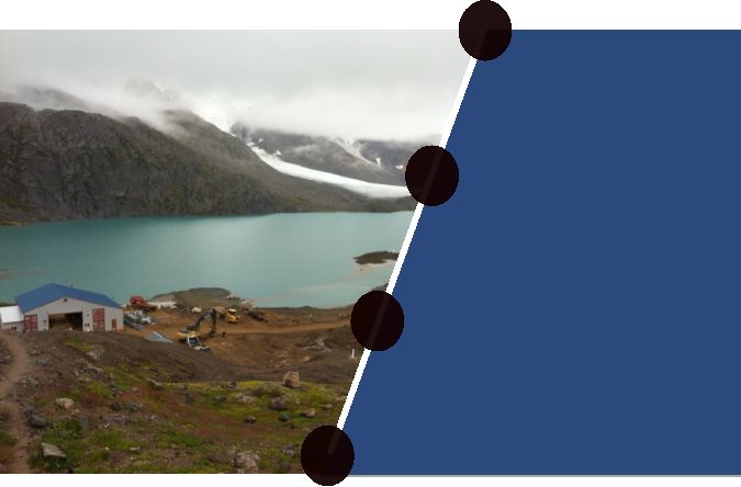
Cover photo credited to the Canadian Environmental Assessment Agency
© Her Majesty the Queen in Right of Canada, represented by the Minister of the Environment, (2015).
Catalogue No: EnXXX-XXX/XXXXF
ISBN : XXX-X-XXX-XXXXX-X
This publication may be reproduced in whole or in part for non-commercial purposes, and in any format, without charge or further permission. Unless otherwise specified, you may not reproduce materials, in whole or in part, for the purpose of commercial redistribution without prior written permission from the Canadian Environmental Assessment Agency, Ottawa, Ontario K1A 0H3 or info@ceaa-acee.gc.ca
This document has been issued in French under the title: Rapport d'évaluation environnnementale préliminaire: Projet de mine d'or Brucejack
Acknowledgement: This document includes figures, tables and excerpts from the Brucejack Gold Mine Environmental Impact Statement, prepared by ERM Rescan for Pretium Resources Inc. These have been reproduced with the permission of both companies. Please refer to the Environmental Impact Statement for all information sources.
Executive Summary
Pretium Resources Inc. (the proponent) proposes to construct, operate, and decommission the Brucejack Gold Mine Project (the Project), a gold-silver underground mine located approximately 65 kilometres north of Stewart, British Columbia (B.C.). The proposed Project would produce approximately 16 million tonnes of mineralized material at a rate of up to 2,700 tonnes per day over a minimum 22-year mine life. An existing 73-kilometre exploration road will be upgraded and used to connect the mine site to Highway 37, east of the Project. Electrical power will be supplied via a 55-kilometre transmission line along a new southern right-of-way connecting to a substation supplied by the Long Lake Hydroelectric Project.
The Canadian Environmental Assessment Agency (the Agency) conducted a federal environmental assessment (EA) of the Project in accordance with the Canadian Environmental Assessment Act, 2012 (CEAA 2012). The Project is subject to CEAA 2012 because it is described in the Regulations Designating Physical Activities as follows:
The construction, operation, decommissioning and abandonment of a new rare earth element mine or gold mine, other than a placer mine, with an ore production capacity of 600 t/day or more.
The Project is also subject to B.C.'s Environmental Assessment Act, 2002 as well as the EA requirements set out in Chapter 10 of the Nisga'a Final Agreement (the Treaty), a modern treaty between Canada, B.C. and the Nisga'a Nation.
This draft EA Report provides a summary and the main findings of the environmental assessment. The Agency prepared the report in consultation with Environment Canada, Health Canada, Natural Resources Canada, Transport Canada and Fisheries and Oceans Canada. The Nisga'a Nation (as represented by the Nisga'a Lisims Government) provided input into the drafting of the report as it pertains to meeting Canada's obligations under the Treaty.
Valued components (VCs) refer to features that may be affected by a project and that have been identified to be of concern by the proponent, government agencies, Aboriginal groups or the public. The EA focused on VCs that pertain to the prediction of environmental effects as defined in section 5 of CEAA 2012. The following is a list of VCs included in the evaluation:
- effects outside Canada;
- fish and fish habitat;
- migratory birds;
- species at risk;
- health and socio-economic conditions of Aboriginal peoples;
- current use of lands and resources for traditional purposes by Aboriginal peoples; and
- physical and cultural heritage of Aboriginal peoples.
The Agency assessed the potential for the Project to cause significant adverse effects on the VCs based on expert opinions and comments provided by Aboriginal communities and the public. These evaluations were completed based on the Environmental Impact Statement provided by the proponent. Key comments from Aboriginal communities related to changes to water quality and quantity, air emissions; heavy metal contamination of country foods, including wild plants and game; access to hunting, fishing, and plant harvesting, socio-economic conditions, cultural use, cumulative effects, and environmental monitoring. These comments were addressed through communication with the proponent and the mitigation measures proposed for the VCs.
The main potential environmental effects from the Project in relation to section 5 of CEAA 2012 are:
- effects on water quantity and quality outside Canada;
- effects on fish and fish habitat downstream of Brucejack Lake;
- effects on migratory birds due to vegetation clearing, artificial lighting and attractants;
- effects on species at risk from habitat degradation and vehicle collisions;
- effects on the health of Aboriginal peoples due to dust and noise levels; and,
- effects on the hunting, trapping, fishing and gathering by Aboriginal peoples from use of the access road.
The proponent's plan and project design incorporates mitigation measures to prevent or reduce the adverse effects of the Project. These include standard mitigation measures, compliance with regulatory standards and specialized best management practices for underground mining and road use.
Accidents and malfunctions could occur due to a failure of the tailings disposal systems, waste rock placement and storage, fuel and concentrate spills or loss of vehicles on the glacier. Effects of the environment on the Project could occur from avalanches, seismic activity, glacial recession and extreme weather events. Cumulative environmental effects were also assessed for each VC from the potential interactions with other projects and activities that have been or will be carried out nearby.
The Project's potential effects on potential or established Aboriginal or Treaty rights were also examined. Fishing, hunting, trapping and gathering by Aboriginal peoples are the primary activities that could be affected by the Project. The Agency is satisfied that these potential impacts have been adequately mitigated or accommodated.
The public submitted comments related to impacts from climate change on the access road over the Knipple Glacier. The Agency is satisfied that the mitigation measures proposed for the potential effects of the environment on the Project are adequate. Concerns related to cumulative effects were also received, however additional mitigation was not considered appropriate.
The Agency identified key mitigation measures to avoid significant effects that include immobilizing tailings as a thickened paste to the bottom of Brucejack Lake and meeting Schedule 4 of the Metal Mining Effluent Regulations and site-specific water quality guidelines for effluent from Brucejack Lake. The proponent will also be required to avoid harming migratory birds, nest and eggs. Speed limits will be imposed along the access road, and the general public will be prohibited from entering the Project area. Follow-up programs will be required to verify the effectiveness of mitigation measures for water quality at the outlet of Brucejack Creek, fish mortality, unauthorized use of the access road, species at risk mortality, and wildlife mortality from vehicle collisions.
Potential adverse but not significant environmental effects were identified on Nisga'a Nation treaty interests in relation to fisheries and migratory birds. The Project is also likely to affect the social and cultural well-being of Nisga'a citizens as the potential inflow of people and income to Nisga'a communities may place additional demand on the existing housing supply and may reduce Nisga'a opportunities to pursue cultural activities. A modest benefit may occur to the economic well-being of Nisga'a citizens due to employment and contracting opportunities associated with the Project.
The Agency will propose conditions in relation to key mitigation and follow-up measures for consideration by the Minister of the Environment. If the Minister issues a decision statement indicating that the Project is not likely to cause significant environmental effects, or if it is determined by the Governor in Council that significant adverse environmental effects are justified under the circumstances those conditions would become legally binding on the proponent.
The Agency concludes that the Brucejack Gold Mine Project is not likely to cause significant adverse environmental effects, taking into account the implementation of mitigation measures.
With respect to potential effects on residents of Nisga'a lands, or Nisga'a interests, the Agency identified potential adverse, but not significant environmental effects on Nisga'a Nation treaty interests. The Agency concludes that the Project will result in both positive and negative effects on the existing and future economic, social and cultural well-being of Nisga'a citizens who may be affected by the Project. Negative economic, social and cultural effects will be addressed through the Project Cooperation and Benefits Agreement between the Nisga'a Nation and the proponent as well as through the management plans proposed by the proponent and required by B.C.
This draft EA Report is being released for public and Aboriginal review. Comments received will be taken into account when finalizing the Report, including the recommended mitigation and follow-up measures to be considered by the Minister as potential environmental assessment conditions. The Final EA Report will be submitted to the Minister of the Environment for consideration when deciding whether or not the Project is likely to cause significant adverse environmental effects, taking into account the implementation of the conditions and mitigation measures that the Minister considers appropriate.
Table of Contents
- Brucejack Gold Mine Project
- Executive Summary
- Table of Contents
- List of Tables
- List of Figures
- List of Abbreviations and Acronyms
- Glossary
- 1 Introduction
- 2 Project Overview
- 3 Project Justification and Alternatives
- 4 Consultation Activities and Advice Received
- 5 Geographical Setting
- 6 Predicted Effects on Valued Components
- 6.1 Outside Canada
- 6.2 Fish and Fish Habitat
- 6.3 Migratory Birds
- 6.4 Species at Risk
- 6.5 Aboriginal peoples – Health and Socio-economic Conditions
- 6.6 Aboriginal peoples – Current Use of Land and Resources for Traditional Purposes
- 6.7 Aboriginal peoples – Physical and Cultural Heritage, and Effects on Historical, Archaeological, Paleontological or Architectural Sites or Structures
- 7 Other Factors Considered
- 7.1 Effects of Accidents or Malfunctions
- 7.2 Effects of the environment on the project
- 7.3 Cumulative Environmental Effects
- 7.3.1 Approach and scope
- 7.3.2 Potential cumulative effects outside Canada
- 7.3.3 Potential cumulative effects on fish and fish habitat
- 7.3.4 Potential cumulative effects on migratory birds
- 7.3.5 Potential cumulative effects on health and socio-economic conditions of Aboriginal Peoples
- 7.3.6 Potential cumulative effects on current use of land and resources by Aboriginal Peoples
- 7.3.7 Potential cumulative effects on physical and cultural heritage of Aboriginal Peoples
- 7.3.8 Views expressed
- 7.3.9 Agency analysis and conclusion
- 8 Nisga'a Nation Effects Assessment
- 9 Impacts on Potential or Established Aboriginal Rights
- 10 Conclusions and Recommendations of the Agency
- 11 References
- 12 Appendices
- Appendix A: Environmental Effects Rating Criteria
- Appendix B: Summary of Environmental Effects Assessment
- Appendix C: List of key mitigation measures, monitoring and follow-up identified by the Agency
- Appendix D: Mitigation measures, monitoring and follow-up proposed by the Proponent
- Appendix E: Aboriginal Issues Tracking Table
- Appendix F: Water Quality
List of Tables
- Table 1: Potentially Affected Valued Components
- Table 2: Flow Data in Brucejack and Sulphurets Creeks, and the Unuk River
- Table 3: Catchment Areas of the Unuk River Watershed
- Table 4: Area of Migratory Bird Habitat Impacted by the Project
- Table 5: Predicted Noise Levels at the Tsetsaut/Skii km Lax Ha Lodge
- Table 6: Criteria Air Contaminants Predictions at the Tsetsaut/Skii km Lax Ha Lodge
- Table 7: Summary of Existing and Reasonably Foreseeable Projects Identified by the Proponent
- Table 8: Valued Components Included in Chapter 10, Paragraph 8(f) Assessment
- Table 9: Regional Development Scenarios Considered in Chapter 10, Paragraph 8(f) Assessment
- Table 10: General Environmental Effects Rating Criteria
- Table 11: Environmental Effects Rating Criteria Specific to Project VCs
- Table 12: Criteria for Determining Significance
- Table 13: Brucejack Creek water quality parameters after water treatment
- Table 14: Sulphurets Creek water quality parameters after water treatment
List of Figures
- Figure 1: Project Location
- Figure 2: Project Components
- Figure 3: General Arrangement of the Mine Site
- Figure 4: Key Watersheds in the Vicinity of the Brucejack Gold Mine Project in Canada
- Figure 5: Water Quantity and Quality Sampling Points in the Unuk River Watershed
- Figure 6: Brucejack Creek Approximately 3m Wide, Below the Lake (Looking Upstream)
- Figure 7: Unuk River Approximately 500m Wide, Near Border Lake Provincial Park at the Canada – U.S. Border (Looking Downstream)
- Figure 8: Map of Brucejack Mine Project, Nisga'a Lands, Nass Wildlife Area and Nass Area
- Figure 9: Jobs Filled by Nisga'a Citizens Under Each Regional Development Scenario
List of Abbreviations and Acronyms
- Agency
- Canadian Environmental Assessment Agency
- CEAA 2012
- Canadian Environmental Assessment Act, 2012
- EA
- Environmental Assessment
- EIS
- Environmental Impact Statement
- NLG
- Nisga'a Lisims Government
- proponent
- Pretium Resources Inc.
- Treaty
- Nisga'a Final Agreement
- VC
- Valued Component
Glossary
- Acid rock drainage
- Acidic water (and possibly water that contains metal(s)) resulting from the chemical weathering of rock or soil material primarily caused by the oxidation of sulphide minerals.
- Adit
- The entrance to a mine that is horizontal, and is used for extracting minerals, ventilation, drawing water, and worker access.
- Best Management Practices
- General term for techniques or methods widely used to achieve an objective in a field due to their effectiveness and practicality.
- Bioaccumulate
- To increase the amount of a substance (for example contaminants) within the tissue of an organism, typically up the food chain.
- Channel
- Natural or artificial watercourse of perceptible extent, with a definite bed and banks to confine and conduct continuously or periodically flowing water. Rivers and streams or a general term for any natural or artificial facility for conveying water.
- Contact water
- Water that comes into contact with mine infrastructure.
- Deleterious substance
- A substance is deleterious if it is harmful to fish, if it limits the use of fish by humans (for example contamination of fish by dioxins or shellfish by E. coli), or if by going through some process of degradation, it harms the water quality (for example, oxygen-depleting wastes). A substance is also deleterious if it exceeds a level prescribed by regulation.
- Echolocation
- The biological sonar by which an animal emits a call and listens to the echoes that return from the surrounding environment. Used for navigation and foraging.
- Effluent
- An effluent – hydrometallurgical facility effluent, milling facility effluent, mine water effluent, tailings impoundment area effluent, treatment pond effluent, seepage and surface drainage, treatment facility effluent other than effluent from a sewage treatment facility – that contains a deleterious substance.
- Erosion
- The wearing away of the land surface by running water, wind, ice or other geological agents, including such processes as gravitational creep. Geological erosion is natural occurring erosion over long periods of time.
- Fisheries windows
- A time of year, usually 4-8 weeks, when fish are less likely to be present in a waterbody due to specific life stages.
- Flocculant
- Chemicals that, when added to a liquid mixture like turbid water, cause suspended particles to aggregate, helping them settle to the bottom of the water column.
- Fugitive dust
- Emissions that escape from industrial processes and equipment and are not controlled or collected. Stone dust, fly ash, soot, and unburned droplets of fuel oil are the main types of particulate resulting from the operation of hot-mix asphalt paving plants.
- Grubbing
- Vegetation removal that involves retaining the root systems for plants.
- Leaching
- A chemical process for the extraction of valuable minerals from ore. Also, a natural process by which groundwater dissolve minerals, thus leaving the rock with a smaller proportion of some of the minerals than it contained originally.
- Measures to Avoid Causing Harm to Fish and Fish Habitat
- Advice from Fisheries and Oceans Canada to help the proponents of projects near water comply with the Fisheries Act.
- Mill
- A plant in which ore is treated for the recovery of valuable metals, or the concentration of valuable minerals for shipment to a smelter or refinery. Also refers to a revolving drum used in the fine grinding of ores.
- Metal Mining Effluent Regulation Limits
- The authorized effluent limits identified in Schedule 4 of the Metal Mining Effluent Regulations for arsenic, copper, cyanide, lead, nickel, zinc, total suspended solids and radium 226.
- Paste Tailings
- Tailings that have thickened with cement to form a paste that binds to contaminants.
- pH
- The acidity (pH less than 7) or alkalinity (pH more than 7) of a solution.
- Project area
- The geographic area occupied by the Designated Project under the control of the Proponent.
- Sedimentation
- The deposition of suspended matter carried in water by gravity, usually the result of reduced water velocity below its ability to transport the material in suspended form.
- Seepage
- The appearance and disappearance of water at the ground surface. Seepage designates the type of movement of water in saturated material. It is different from percolation, which is the predominant type of movement of water in unsaturated material.
- Stope
- The void space left from underground mining after the desired ore body is extracted.
- Subaqueous
- Underwater.
- Tailings
- The waste material and water mixture that is left over after the mill removes the valuable rocks. The rock material in tailings is usually the size of sand grains or smaller.
- Total particulate matter
- Total suspended particulate matter less than 44 microns in diameter. The portion that is between 10 and 44 microns in size is too large to be inhaled; its worst effect would be soiling of materials (for example buildings and cars) and would originate from sources such as windblown dust from stockpiles.
- Trophic levels
- Levels of the food chain. The first trophic level includes photosynthesizers that get energy from the sun. Organisms that eat photosynthesizers make up the second trophic level. Third trophic level organisms eat those in the second level, and so on. It is a simplified way of thinking of the food web. In fact, some organisms eat members of several trophic levels.
- Valued component
- The environmental element of an ecosystem that is identified as having scientific, social, cultural, economic, historical, archaeological or aesthetic importance.
1 Introduction
1.1 Purpose of the Draft Environmental Assessment Report
Pretium Resources Inc. (the proponent) proposes to construct, operate, and decommission the Brucejack Gold Mine Project (the Project), a gold-silver underground mine located approximately 65 kilometres north of Stewart, British Columbia (B.C.) near the Canada - United States (U.S.) border. Mining would occur over a minimum 22-year mine life and produce approximately 16 million tonnes of mineralized material at a rate of up to 2,700 tonnes per day. An existing 73 kilometre exploration road will be upgraded to enable the connection of the mine site to Highway 37, east of the Project. Electrical power will be supplied via a 55 kilometre transmission line along a new southern right-of-way connecting to a substation supplied by the Long Lake Hydroelectric Project.
The purpose of this report is to provide a summary of the information and analysis considered by the Canadian Environmental Assessment Agency (the Agency) in assessing the potential effects of the Project. The Minister of the Environment will consider this report and comments received from Aboriginal groups and the public prior to deciding if the Project is likely to cause significant adverse environmental effects, and whether the Project should proceed.
1.2 Scope of the Environmental Assessment
1.2.1 Environmental assessment requirements
The Project is subject to the Canadian Environmental Assessment Act, 2012 (CEAA 2012) as it involves activities that are set out in paragraph 16(c) of the Regulations Designating Physical Activities. Specifically, the Project includes the construction, operation, decommissioning and abandonment of a new gold mine with an ore production capacity of 600 tonnes per day or more.
Based on the project description submitted by the proponent, the Agency initiated a screening of the designated project to determine if an environmental assessment (EA) was required. On February 8, 2013, the Agency posted a notice on the Canadian Environmental Assessment Registry and invited the public to provide comments on the designated project and its potential environmental effects. On March 25, 2013 the Agency determined that a federal EA was required for the Project and began the EA on March 26, 2013. Requirements of the EA were set out in the EIS Guidelines which are available at: http://www.ceaa.gc.ca.
The Project was also reviewed under B.C.'s Environmental Assessment Act (2002). The Governments of Canada and B.C. applied the principles of the Canada-British Columbia Agreement for Environmental Assessment Cooperation (2004) to align Aboriginal and public consultation and avoid the unnecessary duplication of effort. This cooperative approach included a working group comprised of federal and provincial officials, the Nisga'a Lisims Government and Aboriginal groups, local government agencies, and representatives of federal and state agencies from the U.S.
The Project is subject to the EA requirements set out in Chapter 10 of the Nisga'a Final Agreement (the Treaty), a modern treaty between Canada, B.C. and the Nisga'a Nation. Canada considered whether the project could reasonably be expected to have:
- adverse environmental effects on residents of Nisga'a Lands, Nisga'a Lands or Nisga'a interests, as set out under paragraph 8(e) of the Treaty, and
- effects on the existing and future economic, social and cultural well-being of Nisga'a citizens who may be affected by the Project, as set out in paragraph 8(f) of the Treaty.
1.2.2 Factors considered during the environmental assessment
The following factors were considered as part of the EA pursuant to subsection 19(1)(j) of CEAA 2012:
- the environmental effects of the Project, including the environmental effects of accidents or malfunctions that may occur in connection with the project and any cumulative environmental effects that are likely to result from the project in combination with other physical activities that have been or will be carried out;
- the significance of the effects;
- comments from the public;
- mitigation measures that are technically and economically feasible and that would mitigate any significant adverse environmental effects of the Project;
- the requirements of the follow-up program in respect of the Project;
- the purpose of the Project;
- alternative means of carrying out the Project that are technically and economically feasible and the environmental effects of any such alternative means; and
- any change to the Project that may be caused by the environment.
The EA also considered community knowledge and Aboriginal traditional knowledge under subsection 19(3) of CEAA 2012.
1.2.3 Selection of valued components
Valued components (VCs) refer to features that may be affected by a project and that have been identified to be of concern by the proponent, government agencies, Aboriginal groups or the public. The proponent's VC selection process considered the temporal and spatial scope of the Project and anticipated project-environment interactions. The VCs selected reflect existing knowledge about typical environmental effects of underground mining, concerns raised by the public and Aboriginal groups, and discussions with government agencies.
In its analysis of significance the Agency focused on VCs that pertain to the prediction of environmental effects as defined in section 5 of CEAA 2012: effects on fish and fish habitat, effects on migratory birds, effects outside Canada, and effects on Aboriginal peoples. Some VCs identified by the proponent were outside of federal jurisdiction and therefore not assessed by the Agency. The VCs analysed by the Agency are presented in Table 1.
Additional effects must be considered under subsection 5(2) of CEAA 2012 if carrying out the Project requires a federal authority to exercise a power or perform a duty or function. At the time of this report, no federal authority has identified such requirements, and therefore no additional effects under subsection 5(2) were assessed.
The federal EA also considered the adverse effects of the Project on wildlife species listed on the Species at Risk Act and their critical habitat, as well as effects on species designated by the Committee on the Status of Endangered Wildlife in Canada.
|
Valued Component |
Rationale |
|---|---|
|
Effects identified under paragraph 5(1)(a) of CEAA 2012 |
|
|
Fish and fish habitat |
|
|
Migratory birds |
|
|
Effects identified under paragraph 5(1)(b) of CEAA 2012 |
|
|
Outside Canada |
|
|
Effects identified under paragraph 5(1)(c) of CEAA 2012 |
|
|
Aboriginal peoples – Health and socio-economic conditions |
|
|
Aboriginal peoples – Current use of lands and resources for traditional purposes |
|
|
Aboriginal peoples – Physical or cultural heritage, and effects on historical, paleontological or architectural sites or structures |
|
|
Effects identified under subsection 5(2) of CEAA 2012 |
|
|
Not applicable - no federal decisions identified |
|
|
Effects identified pursuant to subsection 79(2) of the Species at Risk Act |
|
|
Species at risk |
|
|
Effects identified under Chapter 10 of the Nisga'a Final Agreement |
|
|
The report assesses additional VCs specific to the EA requirements described in Chapter 10 of the Treaty |
|
1.2.4 Temporal and spatial boundaries
Spatial and temporal boundaries of an EA are established to define the area and timeframe within which the Project may interact with the environment and cause environmental effects. Temporal boundaries identify when an environmental effect may occur in relation to specific project activities and components. Temporal boundaries are based on the timing and duration of project activities and the nature of the interactions with each individual VC. Temporal boundaries were defined based on Project phases that could adversely affect the environment and are discussed in detail in section 2.3.
The purpose of spatial boundaries is to identify where a Project may result in effects on components of the biophysical environment. Spatial boundaries reflect the geographic range over which the Project's potential environmental effects may occur, recognizing that some environmental effects will extend beyond the immediate vicinity of the Project. Specific spatial boundaries were developed for each VC and are used to assess the effects of the Project on each VC in the context of both a Local Study Area and a Regional Study Area and are discussed in Chapter 6 of this report.
1.2.5 Methods and approach
The Agency reviewed various sources of information in conducting its analysis, including:
- the Environmental Impact Statement (EIS) submitted by the proponent;
- additional information that the Agency requested from the proponent during the review of the EIS;
- advice from expert departments and agencies; and
- comments received from the public and Aboriginal participants.
The Agency's conclusions for the assessment of key VCs are presented using the methodology identified in the Agency's Reference Guide: Determining Whether a Project is Likely to Cause Significant Adverse Environmental Effects.
The significance of any residual effects (after mitigation measures are implemented) on the selected VCs were assessed using the following criteria:
- Magnitude is the scale of the effect relative to the baseline condition;
- Extent is the geographic area over which the effect will occur;
- Duration is the period of time over which the effect will occur;
- Frequency is how often the effect will occur within a given time period;
- Reversibility is the degree to which the effect can or will be reversed; and
- Context is the current sensitivity and resilience of the VC to the change caused by the Project.
The significance of each residual project-related environmental effect was then determined based on pre-defined standards or thresholds (i.e. significance rating criteria). Appendix C summarizes the residual effects assessment for all VCs in relation to routine operations.
The Agency's assessment included both direct effects from the Project and those effects that may result from predicted changes to the environment. The Agency's analysis and conclusions on the significance of impacts on VCs are presented in Chapter 6.
The Agency considers effects to a VC to be "not significant" where the residual effects after mitigation measures have been applied are either minor or moderate in magnitude; localized in geographic extent; short-term in duration; reversible; and have a low impact on the ecological, socioeconomic, or cultural context.
The Agency considers effects to a VC to be "significant" where the residual effects after mitigation measures have been applied would be major or catastrophic in magnitude; long-term; and would have either a medium or high impact on the ecological, socioeconomic, or cultural context. The frequency of an impact is also considered when determining its significance on a VC and, depending on the severity of the impact, can range from a single occurrence to a continuous impact.
2 Project Overview
2.1 Project location
The Project is located approximately 65 kilometres north of Stewart within the Regional District of Kitimat-Stikine (Figure 1).
Figure 1: Project Location

2.2 Project components
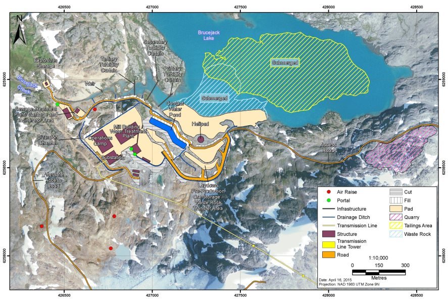
The Project as proposed includes the following components (see Figures 2 and 3):
Underground Mine
The ore body will be developed through an underground mining method called long-hole open stoping. A combination of waste rock and tailings paste will be backfilled into the empty stopes. Mining is proposed to occur at an ore production capacity of up to 2,700 tonnes per day.
Mill/Concentrator
Mineral processing will involve conventional sulfide flotation with gravity concentration. A flotation plant will produce gold-silver concentrate that will be dewatered and trucked off-site for final process and smelting into doré.
Subaqueous Disposal of Waste Rock and Tailings
Approximately 2 million tonnes of potentially acid generating waste rock will be placed in the southwest corner of Brucejack Lake, alongside the approximately 8 million tonnes of flotation tailings. The potentially acid generating rock will form a causeway into the lake and then be capped with non- potentially acid generating rock. A minimum of 1 metre of water cover will be maintained over the waste rock. Tailings will be placed at the bottom of the lake maintaining 30 metres of water above them. By the end of the mine life, approximately 8 million tonnes of flotation tailings will be backfilled into the underground mine stopes as a paste along with 1.9 million tonnes of waste rock.
Explosives Storage
There will be explosives magazines (for storage) at the mine site, both on the surface and underground. Additional explosives magazines will be located at the Knipple Transfer Area and Bowser Aerodrome for avalanche control.
Ore Stockpile
A transfer conveyor will carry the material from the underground crushing area to the main conveyor which travels to the surface. The stockpile will be located in a building with the flotation plant, paste backfill plant, and concentrate stockpile.
Water Collection, Management, Diversion and Treatment Systems
Freshwater diversion channels will be constructed to direct non-contact water away from the Project and into tributaries of Brucejack Lake and Brucejack Creek. The existing sewage treatment plant at the exploration camp will be upgraded to accommodate construction and operation activities.
Associated Buildings, Facilities and Infrastructure
Infrastructure at the mine site will include a truck stop, repair bays, welding bays, maintenance workshops, wash bays, an emergency response facility, mine dry facility and offices. The existing exploration camp will be expanded to support 550 people during construction and 350 people during operations. A smaller, 22-person camp will be located at the Knipple Transfer Area.
Bowser Aerodrome
The Bowser Aerodrome will be constructed on a historic gravel airstrip along the mine access road, approximately 5 kilometres east of the Knipple Transfer Area. It will include a runway, taxiway, apron edge lighting, approach lighting, a helicopter landing area, and an aviation fuel storage area.
Transportation
An existing, gated 73-kilometre mine exploration road begins at Highway 37 near Wildfire Creek, runs west to the Knipple glacier, traverses the Knipple glacier, and then connects to the mine site. The exploration road will be upgraded into a mine access road. The Knipple Transfer Area will be constructed near the base of the Knipple glacier to facilitate the transfer of personnel and materials from road vehicles to tracked vehicles. At this location, a helicopter pad will be located on a laydown area constructed from waste rock with a cap of non- potentially acid generating material.
Transmission Line
A 138 kilovolt transmission line will travel 55 kilometres southeast and connect to a substation supplied by the Long Lake Hydroelectric Project near Stewart. The new right of way is expected to be 30 metres wide for most of the alignment.
Figure 2: Project Components
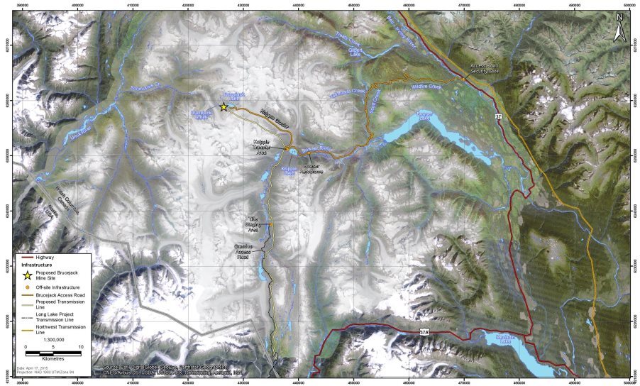
Figure 3: General Arrangement of the Mine Site
2.3 Project Activities and Schedule
Key activities associated with construction, operations, decommissioning and abandonment of the Project as well as anticipated schedules are listed below.
Construction (2 years)
- Development of the underground mine, including creation of production stopes and facilities for mining, crushing and conveying ore;
- Site grading and installation of pads to support the mill building and other infrastructure;
- Installation of the water treatment plant and construction of the surface water management system, paste plant and lined waste rock storage facility;
- Upgrading/realigning the exploration road to become suitable as a mine access road;
- Development of the quarry; and
- Construction of the Knipple Transfer Area, Bowser Aerodrome, Tide Staging Area, and transmission line.
Operation (18 years)
- Mining and crushing of ore underground;
- Ore processing;
- Transportation of concentrate over the Knipple Glacier to the Knipple Transfer Area where it will be transferred to trucks;
- Incineration of solid waste;
- Mineral waste management (waste rock and tailings disposal and paste backfilling); and
- Water collection, management and treatment.
Closure (Decommissioning) (2 years)
- Removal of mining equipment and materials;
- Backfilling of stopes and tunnels;
- Construction of bulkheads to seal access to the underground mine;
- Dismantling of mill, camp, and other infrastructure;
- Disposal of non-hazardous materials into Brucejack Lake;
- Mine access road will be decommissioning and re-vegetating; and
- Transmission line dismantling.
Post-Closure (3 years +)
- Water quality monitoring until long-term environmental objectives are achieved.
3 Project Justification and Alternatives
3.1 Purpose of the Project
The proponent has indicated that the purpose of the Project is to develop its mineral assets to help meet world gold and silver demand and contribute to the natural resource development objectives outlined in the Government of Canada's Economic Action Plan. The proponent expects that the Project will have a positive economic influence on the region, providing business opportunities as well as other spin-off economic benefits.
3.2 Alternative Means of Carrying out the Project
CEAA 2012 requires that every EA of a designated project take into account the alternative means of carrying out the Project that are technically and economically feasible and also consider the environmental effects of any such alternative means. The Agency's Operational Policy Statement Addressing "Purpose of" and "Alternative Means" under the Canadian Environmental Assessment Act, 2012 (CEAA, 2013) sets out the general requirements and approach to address the alternative means of carrying out the designated project under CEAA 2012.
The proponent identified alternative means of carrying out the Project that are technically and economically feasible. Where more than one feasible alternative was identified, the preferred alternative was selected based on the lowest potential for adverse effects to the environment.
Ore Production
The proponent assessed open pit mining and several underground mining methods including block caving, room and pillar and long-hole open stoping. Due to the orientation and grade of the ore body and geotechnical conditions, long-hole open stoping was the only technically and economically feasible option and was selected.
Onsite and offsite options for processing flotation concentrate into doré were assessed and both were found to be technically and economically feasible. While on-site processing was originally proposed, off-site processing was selected as the preferred alternative because it would not require the proponent to use cyanide in the Project area, which could increase risks on receptor VCs.
Mine Waste Disposal Including Rock and Tailings Disposal
Three methods of waste rock disposal were evaluated by the proponent: surface storage, backfilling into the mine and disposal into Brucejack Lake. The area available for surface storage is limited; therefore the other two options were assessed. Backfilling into the mine was the preferred method, however due to mine scheduling and space limitations, disposal into Brucejack Lake would also be required throughout the mine life. The main environmental consideration with regard to waste rock is the potential for acid generation and metal leaching. Both backfilling and lake disposal reduce the potential for these effects as they keep potentially acid generating rock from being exposed to open air where it can oxidize.
Four methods of tailings disposal were evaluated by the proponent including backfilling into the mine, dry stacking and placing either conventional tailings or cementitious (thickened paste) tailings into the lake. Two options were deemed technically feasible and provided the best opportunity to manage environmental effects: disposing cementitious tailings into the bottom of Brucejack Lake during operation, and backfilling paste tailings into the underground stopes where mining is completed.
Treatment of Contaminated Water
Three processes for treating contaminated water were assessed: reverse osmosis, ion exchange and high rate clarification. The high rate clarification process was considered most effective at maintaining water quality and was selected. The other two processes were not suitable as they would neither be capable of removing all potential site-specific contaminants, nor be economically feasible.
Sediment Control
Multiple options were evaluated for controlling sediment release from Brucejack Lake, including the use of turbidity curtains, flocculant, an outlet control structure and the washing of waste rock. Turbidity curtains at the Brucejack Lake outlet as well as around the waste rock disposal area were found to be both technically and economically feasible. An outlet structure could be constructed if the turbidity curtain does not perform as intended. The use of rock washing and flocculating the Lake would neither be effective in removing all sediments nor be economically feasible at this scale.
Transportation Route and Mode
The proponent assessed year-round ground transportation alternatives to the Knipple Transfer Area and the mine site. Three transportation routes to the Knipple Transfer Area were assessed: via the existing mine exploration road that connects to Highway 37; barging across Bowser Lake for part of the route, and constructing a new road south along the Bowser River Valley to the existing Granduc access road. Barging across Bowser Lake was economically feasible, but would neither be capable to transport heavy mining equipment, nor be operational during the winter months. Connecting a new access road to the existing Granduc access road was considered technically unfeasible due to the steep terrain. The upgrading of the existing mine exploration road was the only option that was economically feasible and was therefore selected.
Between the Knipple Transfer Area and the mine site, the proponent considered the upgrading of the mine exploration road across the glacier as well as a tunnel that would avoid crossing it. The only technically feasible option was the glacier access road, which was selected.
The Agency received a comment from the public that using a glacier road would not be feasible for the entire project life, and that alternative means of transportation would eventually be required. The proponent responded that on-going maintenance of the glacier road would be necessary, and that an alternative route was being investigated to maintain access to the mine in the event that the glacier road became impassable
Power Supply
The proponent assessed multiple options for supplying the Project with power including onsite diesel, hydro, solar and wind power generation, as well as three options for connecting to existing power sources. Two options were economically feasible, both of which involved connecting to an existing power source. A transmission line could be constructed east to the Northwest Transmission Line or it could be constructed south to the Long Lake Hydroelectric Project. Following consultation with B.C. Hydro (owner of the Northwest Transmission Line), the east option was no longer feasible because all the power from the Northwest Transmission Line was already allocated to other users. Consequently the south option was selected.
The Agency has reviewed the alternatives assessment conducted by the proponent and is satisfied that the proponent has sufficiently assessed alternative means of carrying out the Project.
4 Consultation Activities and Advice Received
4.1 Aboriginal Consultation
The federal government has a duty to consult Aboriginal groups and, where appropriate, to accommodate, when it has knowledge that its proposed conduct might adversely impact an established or potential Aboriginal or Treaty right. Consultation is also undertaken more broadly as an important part of good governance, meaningful policy development and informed decision-making.
In addition to the federal government's broader obligations, CEAA 2012 requires that all federal EAs consider the effect of any environmental change caused by the Project on the current use of lands and resources for traditional purposes by Aboriginal peoples. It also requires consideration of the effect of any project-related environmental change on the health and socio-economic conditions of Aboriginal peoples, physical and cultural heritage, and "any structure, site or thing that is of historical, archaeological, paleontological or architectural significance".
The Agency coordinated the federal government's consultation for this EA. In this role, the Agency ensured that Aboriginal groups were provided with opportunities to (a) learn about the project, (b) evaluate the project, and (c) communicate their concerns to the federal government.
The Agency identified the following Aboriginal groups for consultation purposes based on the location of the Project and the extent of its potential adverse impacts on potential and established Aboriginal and Treaty rights.
- Nisga'a Nation
- Tsetsaut/Skii km Lax Ha
- Tahltan Nation
- Métis Nation B.C.
Through the Agency's Participant Funding Program, funding was made available to reimburse eligible expenses incurred by Aboriginal groups during their participation in the EA. The Nisga'a Nation received $ 49,499.98 and Métis Nation B.C. received $ 10,500.00 to review and provide comments at key stages of the EA process. Neither the Tahltan Nation nor the Tsetsaut/Skii km Lax Ha submitted applications to receive funding under the Participant Funding Program.
The Agency integrated Aboriginal consultation into the EA process to the greatest extent possible. Key steps in this consultation included the review of the project description, development of the EIS Guidelines, review of the EIS, and preparation of this draft EA Report. The Agency and the B.C. Environmental Assessment Office, conducted joint consultation throughout the EA, shared consultation information (including comments received from Aboriginal groups) and ensured that Aboriginal groups were provided with responses to comments and issues raised throughout the process.
Crown consultation with Aboriginal groups included the following components:
- providing written notification about the Project and EA process;
- corresponding through letters, phone calls, and emails;
- offering meetings to explain the EA process and proposed consultation approach and to seek initial feedback from Aboriginal groups;
- providing opportunities to review and comment on key EA documents, e.g. EIS Guidelines, EIS review, EA Report, conditions; and
- offering face-to-face discussions during key stages listed above to discuss concerns regarding the Project and the consultation process.
4.1.1 Consultation activities related to established Treaty rights
Provisions under Chapter 10 of the Nisga'a Final Agreement (the Treaty) specify the requirements for consultation with the Nisga'a Nation in relation to an EA of a project. The Agency worked collaboratively with the Nisga'a Lisims Government and the B.C. Environmental Assessment Office to ensure that the Nisga'a Nation was informed about the Project and the potential impacts on Nisga'a Treaty rights.
The Project is subject to the EA requirements described in Chapter 10 of the Treaty because it is partly located in the Nass Area and could reasonably be expected (prior to assessment) to have adverse environmental effects on Nisga'a interests set out in the Treaty (Chapter 10, paragraph 6 of the Treaty). Consultation with the Nisga'a Nation was therefore conducted pursuant to the requirements of the Treaty, and also met or exceeded opportunities normally provided to groups considered at the high end of the consultation spectrum as described in the Updated Guidelines for Federal Officials to Fulfill the Duty to Consult, (Aboriginal Affairs and Northern Development Canada, 2011).
The Agency invited Nisga'a Nation representatives to review and provide comments on key documents relating to the EA, including the Project Description, federal EIS guidelines, the EIS and corresponding reports, the draft EA Report, conditions, project recommendations and all of the products associated with the proponent's Economic, Social and Cultural Impact Assessment (see Chapter 8). Additional information was received from Nisga'a Nation representatives through working groups, technical meetings, bilateral and trilateral government meetings, correspondence, and through information sessions in Nisga'a Villages. The Nisga'a Nation also provided draft Economic, Social and Cultural Impact Assessment Guidelines to the proponent to help guide the scope and content of their work.
The substantive aspects of consultation and Treaty implementation with the Nisga'a Nation are described in Chapter 8 of this report.
4.1.2 Consultation activities related to potential Aboriginal rights
Non-treaty Aboriginal groups that were invited to participate in the Agency's consultation activities were identified as having asserted Aboriginal rights that could be adversely impacted by the Project. These groups include Tsetsaut/Skii km Lax Ha, the Tahltan Nation, and Métis Nation B.C. The Agency determined the appropriate level of consultation for each group based on the information available on potential Aboriginal rights and the potential adverse impacts on those rights from the Project. The level of consultation determined the types of consultation activities offered to Aboriginal groups and the level of consideration given to accommodation measures.
Tsetsaut/Skii km Lax Ha
Tsetsaut/Skii km Lax Ha has asserted that they are an independent group for the purposes of Crown consultation. Following discussions with Aboriginal Affairs and Northern Development Canada and the Department of Justice, the Agency agreed to consult the Tsetsaut/Skii km Lax Ha directly for the purposes of the EA of the Project. However, the Agency has not taken a position on the relative independence of Tsetsaut/Skii km Lax Ha from other groups in northwestern B.C.
Some project components, including the access road and the transmission line, fall within Tsetsaut/Skii km Lax Ha asserted territory. Tsetsaut/Skii km Lax Ha assert Aboriginal rights and title in the "Awiiji", including rights to fish, hunt, trap and gather. The Awiiji is a smaller area located in the southwest region of their traditional territory, as documented on maps submitted in the Delgamuukw litigation, which encompasses the west slope of the Oweegee/Strata Mountain Range draining into the Bell-Irving River. The Awiiji area includes part of the access road.
The Agency determined that Tsetsaut/Skii km Lax Ha should be consulted at the high end of the consultation spectrum. Tsetsaut/Skii km Lax Ha were invited to comment on and review key documents relating to the EA, including the Project Description, EIS Guidelines, the EIS and corresponding reports, as well as this draft EA Report. Additional information was exchanged through Working Group meetings, technical meetings, bilateral and trilateral government meetings, correspondence and public meetings.
Tahltan Nation
The Tahltan Nation is comprised of the Iskut First Nation and the Tahltan Indian Band, each with an elected chief. The Tahltan Central Council is the elected governing structure for the Tahltan Nation and has responsibility to represent the Tahltan Nation for issues related to Aboriginal rights and title. During the EA, the Tahltan Nation was represented by elected representatives of the Tahltan Central Council and by members of the Tahltan Heritage Resources Environmental Assessment Team. The southern boundary of the asserted traditional territory of the Tahltan Nation follows the north side of the Unuk River and Treaty Creek. The proposed mine footprint is outside of the southern territory boundary. The access road (from the mine site to Highway 37) overlaps the southern boundary of the asserted Tahltan Nation traditional territory.
The Tahltan Nation has asserted Aboriginal rights and title in their traditional territory, including rights to fish, hunt, trap and gather. The Agency determined that the Tahltan Nation should be consulted at the moderate depth of the Haida consultation spectrum. The Tahltan Nation were invited to comment and review key documents relating to the EA, including the Project Description, Federal EIS Guidelines, the EIS and corresponding reports, as well as through public meetings.
Métis Nation B.C.
Métis Nation B.C. is a consultative body representing chartered Métis communities in British Columbia that asserts, on behalf of its membership, Métis fishing, hunting, trapping and gathering rights and traditional uses throughout most of B.C. The closest Métis chartered communities to the project are the Northwest B.C. Metis Association (based out of Terrace) and the Tri-River Métis Association (based out of Smithers).
The Agency determined that it was appropriate to consult Métis Nation B.C. at the low end of the consultation spectrum. Métis Nation B.C. was invited to comment and review key documents relating to the EA, including the Project Description, Federal EIS Guidelines, the EIS and corresponding reports.
4.1.3 Aboriginal consultation activities by the proponent
The legal responsibility to consult and accommodate rests with the federal government. However, the efforts of the proponent can assist in the overall consultation process and inform not only the assessment of potential adverse impacts of the Project on potential or established Aboriginal and Treaty rights, but also appropriate mitigation or accommodation measures that may be required to address the potential impacts. Information collected by the proponent during its Aboriginal consultation program was considered in the Agency's determination of any potential adverse impacts of the Project on potential or established Aboriginal and Treaty rights.
The proponent engaged with the Aboriginal communities identified by the Agency and the B.C. Environmental Assessment Office, through meetings, phone calls, emails, correspondence, and the proponent's responses to concerns identified during the review of the EIS. The proponent met with the Nisga'a Nation, Tsetsaut/Skii km Lax Ha and Tahltan Nation prior to the EA process in order to provide an introduction to the Project. Subsequent engagement meetings allowed for discussion of Aboriginal issues, consultation and engagement, cumulative effects, current use of lands and resources for traditional purposes, and other effects.
The Nisga'a Nation, Tsetsaut/Skii km Lax Ha and Tahltan Nation were provided with opportunities to comment on draft technical materials prepared by the proponent for review by the EA Working Group. The proponent also participated in a series of five open houses organized jointly by the Agency and the B.C. Environmental Assessment Office, from November 25-28, 2013 in New Aiyansh, Stewart, Hazelton, Dease Lake and Iskut, to which all Aboriginal groups were invited. The proponent has committed to continuing engagement with Aboriginal groups, by reviewing and responding to their comments, discussing the potential effects of the Project on Aboriginal rights and interests, mitigating or accommodating these effects, and pursuing other engagement activities as may be required by the federal government.
4.2 Public Consultation
4.2.1 Public participation in the environmental assessment process
CEAA 2012 requires that the public be provided with a minimum of three formal opportunities to participate in every federal EA. For this Project, the Agency provided four opportunities for public participation:
- an opportunity to comment on a summary of the Project Description;
- an opportunity to comment on the draft EIS Guidelines;
- an opportunity to comment on the summary of the proponent's EIS; and
- an opportunity to comment on this draft EA Report and proposed conditions.
Notices of these opportunities to participate were posted on the Canadian Environmental Assessment Registry and advertised through local media.
Hardcopies of the draft EIS Guidelines were made available at public viewing centres in the Town of Smithers, Stewart, and City of Terrace. The EIS Summary and the EIS were made available at public viewing centres in the Project area. During the review of the EIS, the Agency conducted five information sessions in the Towns of New Aiyansh, Hazelton, Dease Lake, Stewart and Iskut. These information sessions, attended by 122 participants, were held jointly with the B.C. Environmental Assessment Office. They provided opportunities for members of the public to hear presentations on the EA process, review the proponent's EIS, ask questions and provide comments. Those comments were considered in the preparation of this draft EA report. The Agency also received written comments from a professor with the University of Northern British Columbia, as well as from Rivers Without Borders.
The Agency is now inviting the public to provide comments on the content, conclusions and recommendations set out in this draft EA report as well as on the proposed Conditions that the Minister of the Environment may consider when making the decision. After taking into consideration the comments received from the public, the Agency will finalize and submit the report to the Minister of the Environment.
4.2.2 Public participation activities by the proponent
The proponent participated in the five information sessions on the EIS described above. The Proponent also conducted meetings with local businesses and community groups prior to and following EIS submission. The proponent distributed information through its corporate website, information booklets, posters/storyboards, videos and presentations. Questions and comments from the public were solicited though phone, email, website, and through comment cards distributed at information sessions.
4.3 Advice Received from Federal and Other Experts
Environment Canada, Health Canada, Natural Resources Canada, and Transport Canada provided specialist advice in relation to the Project. They helped determine whether a federal EA was required, reviewed the draft EIS Guidelines and the EIS, and provided input into the preparation of this report.
Environment Canada provided advice related to climate change, migratory birds, species at risk, hydrogeology, and water quality. Health Canada provided advice on effects of changes to air quality, noise, drinking water quality and country foods resulting from changes to the environment with respect to Aboriginal peoples. Natural Resources Canada provided advice related to geohazards, seismicity, glaciers and hydrogeology. Transport Canada provided advice related to navigation. Following an initial review of the project description, Fisheries and Oceans Canada concluded that there was a low potential for impacts related to fish and fish habitat and therefore did not participate further in the review.
Aboriginal Affairs and Northern Development Canada provided advice related to the fulfilment of Nisga'a Final Agreement requirements.
5 Geographical Setting
5.1 Biophysical Environment
The biophysical landscape in the Project area is characterized by mountainous topography and glaciers typical of northwestern B.C. Weather systems from the Pacific Ocean produce strong winds during all seasons at the mine site, and moderate winds along the access road. Mean annual precipitation in the Project area ranges from 1,000 – 2,200 millimetres annually.
The Project is in a remote region with no anthropogenic sources of air emissions from industrial or commercial activities. The regional study area for air quality was set as a 30 by 30 kilometre grid located around the mine site, which was used to predict the potential effects from the Project on air quality in both the Unuk and Bowser River watersheds. The aerodrome, Knipple Transfer Area and portions of the transmission line and access road were included in the regional study area. The nearest emission sources are from vehicle traffic along Highway 37, the Long Lake Hydro Project and the District of Stewart. Parameters assessed included sulphur dioxide, nitrogen dioxide, carbon monoxide, dust fall and particulates (PM10 and PM2.5). Data collection was impacted by wind and precipitation and could therefore be seasonably variable.
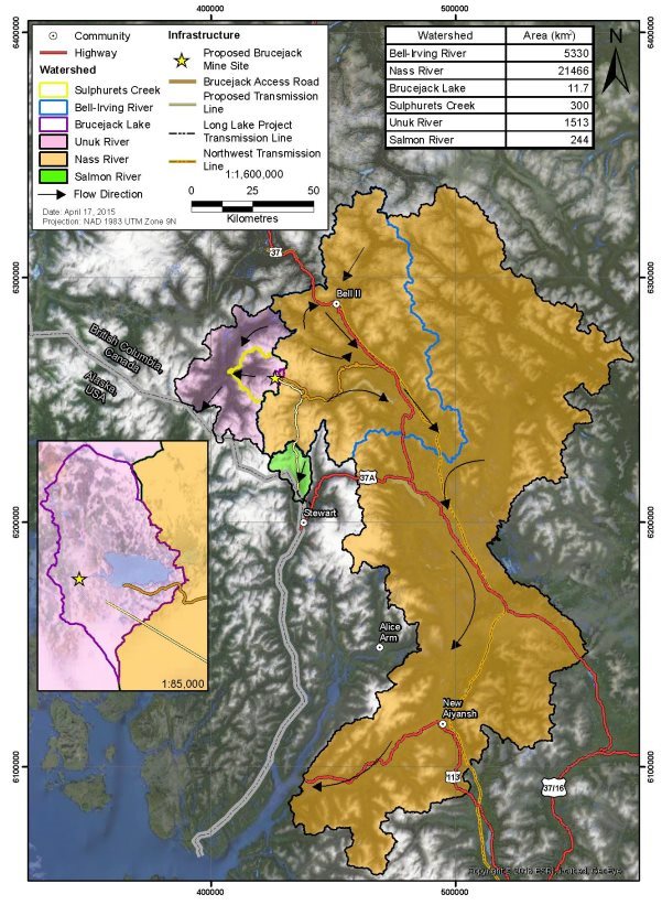
Project components are located in three watersheds (Figure 4): the Unuk River watershed (mine site) and Bell-Irving River watershed (access road and transmission line), and the Salmon River watershed (transmission line).
Unuk River Watershed
The mine site is directly adjacent to Brucejack Lake, located above the tree line in a glaciated mountainous area with an elevation of 1,400 m that has reduced forest productivity due to wet soils, heavy snowfall and prolonged wind exposure. Brucejack Lake drains into Brucejack Creek, which flows northwest into Sulphurets Creek. This water ultimately enters the Unuk River and flows southwest into Alaska. Brucejack Lake has a low nutrient level and is not fish-bearing; however there are a variety of salmon species 22 kilometres downstream of the Project, below a waterfall that forms a natural fish barrier near the mouth of Sulphurets Creek, and further downstream in the Unuk River. The area includes sparse vegetation and some wildlife presence. Vegetation consists of mountain hemlock, sub-alpine firs, mountain heather and western hemlock at lower elevations. Mountain goats, hoary marmots, wolverines, martens, and some land birds were observed in the area throughout the year.
The mine site around Brucejack Lake has been disturbed by mining exploration and underground development since 1986. Both the Brucejack and Sulphurets drainages are highly mineralized and show seasonal variation in elevated levels of contaminants. Natural exceedances of water quality guidelines are observed for cadmium, silver and zinc in Brucejack Creek. Baseline studies also identified naturally elevated levels of aluminum, arsenic, cadmium, cobalt, copper, iron, mercury, manganese, lead, selenium, silver and zinc downstream of the fish barrier in Sulphurets Creek. Water quality sampling in the Unuk River shows an increase in the level of metals from Sulphurets Creek and natural concentrations of aluminum, arsenic, cadmium, chromium, copper, iron, and zinc that exceed water quality guidelines.
Figure 4: Key Watersheds in the Vicinity of the Brucejack Gold Mine Project in Canada
Bell-Irving River Watershed
The access road and transmission line are within the Bell-Irving watershed, which includes the Bowser Lake, Bowser River, Todedada, Wildfire and Scott Creeks, all of which ultimately flow east into B.C.'s Nass River. These water bodies all support various fish species including salmon. The surrounding landscape includes steep forested terrain, wetlands, creeks and valleys that host migratory birds and other wildlife species. The landscape surrounding the mine access road to the Knipple Transfer station is characterized as cool and moist year-round with rugged mountainous terrain, a productive growing season and a dense shrub layer. Snow may persist for 6-9 months of the year favoring moisture-loving species such as devil's club, oak fern, sub-alpine fir, cedar and spruce. In addition there are a diversity of wetlands present throughout the Bowser River watershed that support a variety of functions (hydrology, habitat) and species (rare plants, lichens, fish, birds, amphibians). Various wildlife species were found to use the watershed including moose, mountain goat, grizzly bears, American marten, wolverine, fisher, hoary marmot, western toad, bats, raptors and migratory birds.
The 12 kilometre glacier road that crosses the Knipple glacier is subject to high snowfall and winds. The transmission line runs through steep terrain and variable habitat types similar to both the mine site and the access road.
Salmon River Watershed
The southern half of the transmission line is within the Salmon River watershed which ultimately flows into the Portland Canal. The surrounding landscape is steep mountainous terrain with high energy streams. The area experiences high levels of precipitation year-round and supports fish and wildlife species similar to those described for the Bell-Irving watershed.
5.2 Human Environment
The regional economy is supported primarily by extractive industries including mining and forestry. Other activities in the region include commercial heli-skiing, guide outfitting, hunting, registered trap lines, angling licences and other commercial recreation tenures. Traditional use of the land by Aboriginal people is discussed in section 6.6 of this report. The only permanent residence is the privately owned Tsetsaut/Skii km Lax Ha Lodge, which is located close to the Bowser camp facilities along the Brucejack access road and near the proposed Bowser Aerodrome. Two additional lodges which are used seasonally are located at the mouth of Bell Creek and the mouth of Bowser Lake.
The construction of the mine exploration road from Highway 37 to Brucejack Lake has made the mine site accessible to contractors based in Stewart, the closest local municipality (65 kilometres south of the mine site; 190 kilometres by road), as well as Terrace (380 kilometres by road). The proposed transmission line would connect the mine to a substation supplied by the existing Long Lake Hydroelectric Project, which is located 55 kilometres south of the mine site (about 10 kilometres north of Stewart).
6 Predicted Effects on Valued Components
6.1 Outside Canada
6.1.1 Proponent's assessment of environmental effects
Predicted Effects
The assessment of potential effects outside Canada focused on surface water flowing from the mine site into the transboundary Unuk River watershed, and from the southern portion of the transmission line into the transboundary Salmon River watershed. The mine access road and the northern portion of the transmission line are situated within the Bell-Irving River watershed, which flows into the Nass River and drains into Canadian waters. Effects to fish and fish habitat from the Project are discussed in Chapter 6.2.
The Project is not expected to impact air quality outside Canada. Air quality effects are only predicted in an area immediately south of the Knipple Transfer Area (see Chapter 6.5), which is 36 kilometres from the border in an area where prevailing winds blow from the U.S. into Canada.
Unuk River watershed
Surface water at the mine site flows a total of 53 kilometres before it reaches the U.S. border (Figure 5). Mine runoff is directed to Brucejack Lake, which drains into Brucejack Creek (Figure 6) and then flows beneath the Sulphurets Glacier into Sulphurets Lake. Sulphurets Lake then drains into Sulphurets Creek, which receives runoff from the proposed Kerr-Sulphurets-Mitchell Mine (KSM) Project before it joins the Unuk River. The Unuk River then joins the South Unuk River and crosses the Canada - U.S. border at Border Lake Provincial Park (Figure 7). The assessment of effects outside Canada therefore considered impacts on the quantity and quality of water flowing across the international border.
Water Quantity
The Proponent presented data on current discharge levels from Brucejack Lake and compared them to discharge levels at the sampling points in Sulphurets Creek and Unuk River (Table 2). Sampling of total discharge in the Unuk River was conducted from 1957 to 1995. These data show that Brucejack Lake contributes an average of 0.55% of the water at low-flow periods, and 0.62% of the annual flow in the Unuk River at the border.
The proponent modeled potential changes in flows in Brucejack Creek during each phase of the Project, and predicted a 26% increase in Brucejack Creek during low-flow periods (from a baseline of 0.07 m³/s to 0.11 m³/s during construction and operation).This change will be indistinguishable in the Unuk River where seasonal fluctuations range from 15 to 260 m³/s for the same time periods.
Figure 5: Water Quantity and Quality Sampling Points in the Unuk River Watershed
Figure 6: Brucejack Creek Approximately 3 metres wide, Below the Lake (Looking Upstream)
Figure 7: Unuk River Approximately 50 metres wide, Near Border Lake Provincial Park at the Canada – U.S. Border (Looking Downstream)
|
Brucejack Creek (m³/s) |
Sulphurets Creek (m³/s) |
% contribution of Brucejack Creek to Sulphurets Creek |
Unuk River (m³/s) |
% contribution of Brucejack Creek to Unuk River |
||
|---|---|---|---|---|---|---|
|
*Annual flow values are an average over the entire year |
||||||
|
Baseline |
Low Flow (February/March) |
0.07 |
3.11 |
2.25 |
14.9 |
0.47 |
|
Annual Flow* |
0.64 |
22.34 |
2.86 |
105.4 |
0.61 |
|
|
Construction phase |
Low Flow |
0.11 |
3.15 |
3.49 |
14.94 |
0.74 |
|
Annual Flow |
0.69 |
22.38 |
3.08 |
105.44 |
0.65 |
|
|
Operations phase |
Low Flow |
0.11 |
3.15 |
3.49 |
14.94 |
0.74 |
|
Annual Flow |
0.68 |
22.38 |
3.04 |
105.44 |
0.64 |
|
|
Closure phase |
Low Flow |
0.05 |
3.09 |
1.62 |
14.88 |
0.34 |
|
Annual Flow |
0.63 |
22.33 |
2.82 |
105.39 |
0.60 |
|
|
Post-Closure phase |
Low Flow |
0.07 |
3.11 |
2.25 |
14.9 |
0.47 |
|
Annual Flow |
0.64 |
22.34 |
2.86 |
105.4 |
0.61 |
|
Since flow data from 1957 to 1995 may not represent current discharge levels, the proponent also compared rainfall catchment areas to supplement its analysis (Table 3). The area of the Brucejack Creek watershed is 0.8% of the Unuk River watershed, which suggests that Brucejack Creek contributes a similarly small percentage of flow to the Unuk River watershed. Within the Brucejack Creek watershed, Brucejack Lake contributes 1.3% of surface water flow, and the Project mine site itself only contributes a portion of flow in Brucejack Lake. Taken together, it is expected that surface water flow from the Project will only contribute a very small amount of flow in the Unuk River at the border (0.01%).
|
Brucejack Lake (Mine Site) |
Brucejack Creek watershed |
Sulphurets Creek watershed |
Unuk River watershed in Canada |
|
|---|---|---|---|---|
|
Catchment Area (kilometres2) |
0.15 |
11.7 |
298.6 |
1480 |
|
Percent area of Unuk River watershed in Canada (%) |
0.01 |
0.8 |
20.2 |
100 |
Water Quality
Impacts to surface water from changes to water quality parameters (dissolved and total metals, suspended solids, nitrogen loads, and pH) may occur because waste rock, tailings, dust, and contact water (made up of treated mine effluent, blast residues, and run-off) will enter Brucejack Lake. The proponent developed models to predict the level of parameters downstream in Brucejack and Sulphurets Creeks during low-flow periods when concentrations would be greatest (Appendix F).
The model includes baseline conditions of parameter levels (naturally present), predicted concentrations during each phase of the Brucejack Gold Mine Project, and concentrations predicted for each phase of the nearby proposed KSM Project. The predictions were compared with baseline conditions, and against the authorized limits of deleterious substances in Schedule 4 of the Metal Mining Effluent Regulations under the Fisheries Act, the Canadian Environmental Quality Guidelines, and the B.C. Water Quality Guidelines[1].
Metal Mining Effluent Regulations limits are measured at the point of discharge, which in this case is the outlet of Brucejack Lake into Brucejack Creek, and are higher than those in the other guidelines. The Canadian Environmental Quality Guidelines and the B.C. Water Quality Guidelines thresholds are measured in the receiving environment after dilution, which in this case is Brucejack and Sulphurets Creeks.
The baseline levels in water leaving Brucejack Lake do not exceed any federal or provincial thresholds. Levels were then modeled for each phase of the Project, and parameters will also not exceed any Metal Mining Effluent Regulations Schedule 4 limits. The Project may however result in the exceedance of some B.C. Water Quality Guidelines and/or Canadian Environmental Quality Guidelines thresholds in Brucejack Creek, some of which may affect water further downstream in Sulphurets Creek after dilution in the receiving environment (see Appendix F).
The baseline levels in Sulphurets Creek (which includes water quality data from the proposed KSM Project) do not exceed Metal Mining Effluent Regulations limits, but do exceed the B.C. Water Quality Guidelines and/or Canadian Environmental Quality Guidelines thresholds for aluminum (total), arsenic, cadmium, iron, zinc, and copper. While these future exceedances may be attributed to the Project, they may also be caused by natural mineral deposits and the development of the proposed KSM Project, which is fifty times larger than the Brucejack Gold Mine Project.
The Project may contribute to the exceedance of B.C. Water Quality Guidelines for ammonium and aluminum (dissolved) but, based on the flow predictions summarized above, this contribution is unlikely to be measurable above natural levels. Provincial officials have indicated that site-specific water quality objectives will be developed for key parameters in Brucejack Creek during the provincial permitting phase.
Salmon River watershed
The southern portion of the transmission line is located in the transboundary Salmon River watershed. The transmission line will be constructed high enough to enable the towers to be set back from any watercourse crossings to leave the riparian zone intact. The towers will be installed by helicopter, to avoid needing a road to be built along the right-of-way. Transmission cables will be installed in a manner that avoids disturbing riparian habitat and any water that may flow outside of Canada. The transmission line is not predicted to result in any water quality or quantity impacts in the Salmon River watershed.
Proposed Mitigation Measures, Monitoring and Follow-Up
Mitigation measures for addressing potential impacts to water quantity in the Unuk River watershed include using a variety of water diversion and collection structures at the mine site designed in a manner that diverts non-contact water away from the project while limiting fluctuations in flow.
To mitigate effects to water quality in the Unuk River watershed the proponent proposes to capture and treat all contact water at the mine site. The treatment plant will remove particulate matter, nutrients and dissolved metals, and stabilize the pH. The treatment plant will be upgraded for the Operations phase to manage expected increases in particulate matter and nitrite levels from the mining process. Diverting non-contact water around the Project and into Brucejack Creek to reduce impacts on water quantity will also help reduce impacts to water quality by limiting the amount that may become contaminated.
To mitigate impacts, mine tailings will be mixed them with cement and a binder to form a thickened paste. The proponent will put half of the paste tailing along with half of the waste rock back into the mine, and then flood it to limit acid rock drainage and reduce impacts to water quality.
The remainder of the paste will be piped into the lake to form a mound on the bottom. This will ensure that the mine tailings remain in the lake without requiring a dam to prevent them from flowing downstream. The paste will bind to dissolved metals and prevent them from leaching into the water column. Remaining waste rock that cannot be backfilled into the mine will also be placed underwater into Brucejack Lake to prevent it from leaching metals into the environment.
A series of three turbidity curtains will be installed before the outlet of Brucejack Lake to reduce sediment transport downstream if it is kicked up during waste rock placement or paste tailings deposit. An additional proposed measure to mitigate sediment transport is to add flocculants (a chemical that causes suspended particles to aggregate, inducing them settle to the bottom of the water column).
Predicted Residual Effects
The proponent does not predict any observable residual effects on the quantity of water outside of Canada. At closure, the empty space in the mine will be flooded with water from the lake, which will reduce the amount of water flowing out of the lake as the mine fills-up. There will be a 27% drop in the volume of water leaving Brucejack Lake for the first three years after closure, but this fluctuation will also not be detectable in Sulphurets Creek, or further downstream at the Canada-U.S. border.
Some uncertainty remains with respect to the effectiveness of the water treatment plant in mitigating water quality impacts in Brucejack Creek. However, since the Brucejack watershed contributes so little to both the Sulphurets and Unuk watersheds, any potential impacts to water quality should not be observable beyond natural fluctuations either in Sulphurets Creek, or in the Unuk River at the Canada-U.S. border.
6.1.2 Views expressed
Government Authorities
Environment Canada was concerned with selenium loadings from the Project and its potential to impact the Unuk River, as well as elevated arsenic, chromium and zinc in the Unuk River. The proponent showed that any changes in dissolved metal concentrations would not be distinguishable from natural variation. Environment Canada also commented that at closure there will be a "first flush" of dissolved metals when the mine is flooded and the water initially makes contact with the tailings and waste rock. This first flush may result in mine water metal and nutrient concentrations higher than what the water treatment plant is able to treat. The proponent proposes to manage impacts from a first flush by cycling the treated water back into the mine and then sending it through the water treatment plan again for retreatment. This process can be repeated as many times as needed.
The U.S. Environmental Protection Agency and the State of Alaska expressed concerns regarding selenium monitoring during the closure phase of the project as it has the potential to affect birds and wildlife, as well as cumulative effects on water quality and its potential effects on Alaskan fisheries. The Proponent responded to government concerns by recalibrating its water quality model with conservative parameters, and demonstrated that even in a worst case scenario it would still not be possible to detect any residual impacts to water quality in the Unuk River watershed at the Canada-U.S. border. As described in Appendix F selenium concentrations for all phases of the project are predicted to be below B.C. Water Quality Guidelines in Brucejack Creek. The proponent reiterated that, because the Brucejack catchment area is only 0.8% of the Unuk River catchment area, and because the Brucejack Creek discharge levels are only 0.55-0.62% of Unuk River discharge levels, there will be no detectable effects to water quality from selenium at the border.
Provincial authorities questioned the effectiveness of the proposed water treatment plant. They requested that the proponent provide independent validation to prove that the technology will function as intended. The proponent is in the process of providing this information which is also required as part of the conditions developed by the B.C. Environmental Assessment Office.
Aboriginal Groups
Aboriginal groups commented that there may be impacts to fish from water quality in the Unuk River watershed. Tsetsaut/Skii km Lax Ha and the Tahltan Nation expressed concerns about potential increases in metal concentrations accumulating in fish tissues, and impacts related to suspended solids from tailings and their placement. Tsetsaut/Skii km Lax Ha recommended that monitoring be conducted at all locations where there is a potential for metal leaching or acid rock drainage. The proponent responded that it will monitor water quality at the outlet of Brucejack Lake. It also said that any changes to metal concentrations and sediment load in fish habitat (located 20 kilometres downstream in Sulphurets Creek) would not be measurable because baseline concentrations are already high.
Public
The public commented that underground tailings and waste rock storage could impact groundwater, and that there is a potential for contaminated water to drain into the Unuk River watershed that would affect downstream fish stocks. The proponent indicated that all mine water will be treated prior to entering Brucejack Lake, that no contaminated groundwater will connect to surface waters and that, since the amount of water leaving the Project area makes up such a small percentage of the total volume at fish habitat, that there will be no impacts to the Unuk River watershed or to U.S. fisheries (section 6.2).
6.1.3 Agency analysis and conclusion
Analysis of the Effects
The Agency concludes that Project will not result in any measurable impacts to water quantity at the Canada-U.S. border. The amount of water that the Brucejack watershed contributes to the Unuk River watershed is very low (less than 1%), so any changes will be below detection limits and therefore negligible.
The Project will result in increases in metals, nutrients and suspended solids being released into Brucejack Creek, some of which will exceed water quality guidelines. However, with the described flow rates and the application of mitigation measures, it is unlikely that these changes will be measurable at the Canada-U.S. border. None of the parameters in the effluent discharge will exceed the authorized limits of deleterious substances from Schedule 4 for the Metal Mining Effluent Regulations in Canadian waters.
It is unlikely that any Project-related changes in water quality will be detectible in Sulphurets Creek, and further downstream in the Unuk River. Also, because there are multiple inputs in Sulphurets Creek, including the proposed KSM Project, it will be necessary to attribute any changes in parameter concentrations to the Project. As such site-specific water quality guidelines unique to the Brucejack Gold Mine Project will be developed with the province in consultation with Aboriginal groups and local authorities. These will establish appropriate limits to ensure that the Project does not impact downstream water quality.
Uncertainty remains as to whether the proponent's water treatment plant will function as predicted because concentration estimates presented by the proponent regarding the effectiveness of the water treatment plant were based on professional judgment. Typically the effectiveness of a water treatment system is developed using either a proxy (similar model currently being used at another mine) or bench tests (laboratory testing). To address this, the proponent has committed to providing bench tests prior to mine operations to confirm that the water treatment plant will function as intended. Nevertheless, since Brucejack Lake contributes such a small percentage of the water in both the Sulphurets and Unuk watersheds, it is unlikely that any exceedances will be observable.
Key Mitigation Measures to Avoid Significant Effects
Key mitigation measures for water quality include immobilizing tailings on the bottom of Brucejack Lake using a thickened paste, ensuring that waste rock is covered with water to avoid oxidation, and collecting and treating all contact water before it enters the lake. Some residual effects are likely if the water treatment plant does not remove all metals and nutrients as expected. Backfilling half of the paste tailings and waste rock into decommissioned stopes and installing multiple turbidity curtains at the outlet of Brucejack Lake will be necessary to ensure that the water treatment plant is not overwhelmed, and to manage suspended solids being transported downstream. After mitigation the Agency does not predict any residual effects outside of Canada.
Follow-up
The follow-up programs required to verify the accuracy of the effects predicted in relation to outside of Canada include:
- Water quality monitoring at the outlet of Brucejack Creek as per the requirements of schedule 4 of the Metal Mining Effluent Regulations and any site-specific water quality objectives set by B.C. to determine the effectiveness of the water treatment plant and the tailings disposal method.
Conclusions
Taking into account the implementation of the mitigation measures and follow–up programs described above, the Agency is of the view that the Project would not result in any significant adverse environmental effects outside of Canada.
6.2 Fish and Fish Habitat
6.2.1 Proponent's assessment of environmental effects
Unuk River Watershed
Fisheries and Ocean Canada determined that Brucejack Lake and Brucejack Creek are not fish-bearing. The nearest waterbody containing fish and fish habitat in the Unuk River watershed is 20 kilometres downstream of the Project below a fish barrier (waterfall) in Sulphurets Creek. The impacts from the mine on fish and fish habitat in the Unuk River watershed are therefore limited to water quality and quantity effects.
Fluctuations in water quantity are not expected to impact fish and fish habitat in Sulphurets Creek, because flow from Brucejack Creek only contributes 2.62-2.93% to the flow in the Sulphurets system (depending on the time of year), and the Brucejack catchment area makes up only 3.9% of the Sulphurets catchment area. Impacts from change in water quantity on fish and fish habitat are therefore not expected.
Leachates from waste rock and tailings may impact water quality in Brucejack Lake and Brucejack Creek during all phases of the Project. Process chemicals including potassium amyl xanthate (ore processing), lime and/or sodium hydroxide (water treatment), hydrochloric acid (water treatment), and flocculants (water treatment) may be released from the metal mill. The use of explosives and the disposal of effluent from the sewage treatment plant may introduce nitrogen and phosphorus compounds.
The release of metals, nitrogen, phosphorus, and petroleum products can degrade water quality and alter pH. Fish exposed to extremes in metals, nutrients or pH can experience lethal and sub-lethal effects, which can affect long term population dynamics or stability. Some metals like mercury, arsenic and selenium can bio-accumulate through food chains and pose a risk to species higher in the food chain. Selenium is projected to increase and exceed B.C. Water Quality guidelines in Sulphurets Creek (unlike in Brucejack Creek) during the life of the project however, as described section 6.1, since the contribution of Brucejack Creek to Sulphurets Creek is so small, any observed increases are likely from other sources increasing the baseline levels (e.g.: natural mineralization, and the proposed KSM Project).
Bell-Irving River Watershed
Direct effects on fish and fish habitat in the Bell-Irving River watershed could be caused by erosion and sediment from the upgrade, maintenance, and use of the access road (e.g., materials accidently pushed into streams, loosening rock and soil along stream banks), and from runoff during seasonal rains. Sediment entering the aquatic environment can increase turbidity in downstream waterways and may occur from slope failures, debris torrents, and avalanches associated with the access road and its stream crossings.
Debris torrents in streams can scour stream channels to bedrock, depositing fine sediment in downstream habitat, and potentially block access to upstream habitat. In summer the access road will dry-out and dust can be kicked-up by trucks and deposited into streams. Increases in turbidity from sediment can smother fish eggs and fry, block oxygen transport, reduce feeding efficiency, expose fish to elevated metal concentrations, and lead to habitat avoidance. Elevated suspended solids from sediment can also physically damage and clog gills of adult fish, reduce spawning ability and predator evasion.
Fish habitat loss or alteration along the access road could include the loss of riparian vegetation along the right-of-way, primarily at stream crossings.
The mine exploration road was constructed before the current project was proposed. Provincial approval of the exploration road included the consideration of potential impacts on fishing in the Bell-Irving River watershed, and resulted in the proponent adding a gate to the road at its intersection with Highway 37, and to prohibit fishing by mine workers within the gated area. Both measures have mitigated potential impacts related to increased access to fishing in the Bell-Irving River watershed, and will be integrated into the mitigation measures considered as part of this assessment on the upgrade and operation of the mine access road.
Salmon River Watershed
Any adverse effects on fish and fish habitat in the Salmon River watershed would result from impacts to water quality, which is discussed in section 6.1.1.
6.2.2 Proposed mitigation measures, monitoring and follow-up
Unuk River Watershed
Mitigation for impacts to fish and fish habitat in the Unuk River watershed are all related to water quality, which are discussed in section 6.1.2. Unintended spill from process chemicals and blast residues are addressed in Chapter 7.1 – Accidents and Malfunctions.
Bell-Irving River Watershed
Impacts to fish and fish habitat in the Bell-Irving River watershed will be managed by preventing erosion and capturing sediment before it enters the water in a manner consistent with Fisheries and Oceans Canada's Measures to Avoid Causing Harm to Fish and Fish Habitat. Erosion will be reduced by retaining existing vegetation and avoiding grubbing where possible. Blankets, biodegradable mats, and planted vegetation will be used as needed to provide more protection and restore disturbed soils. Slopes along road edges will be graded to ensure that they are stable and do not slump into ditches and creeks, and work will occur away from water courses. Any piles of excavated material will also use erosion control techniques and will be stored away from watercourses.
Sediment will be prevented from entering streams by diverting water to vegetated areas and using control structures such as silt fences and geotextile cloth to capture any suspended solids. Water will be sprayed along the access road as a dust suppression measure during the summer. In-stream work will occur during specific fisheries windows (when fish are not present) to prevent any blunt force trauma from machinery, and to limit any water quality impacts on fish.
6.2.3 Predicted residual effects
Unuk River Watershed
The proponent concluded that, while there may be residual effects to water quality in Brucejack Creek, since the Project contributes less than 1% to the overall volume of the Sulphurets system (Table 6.1-1), and because contact water will undergo treatment before being released to the environment, no measurable residual effects on fish habitat 20 kilometres downstream of the mine site in Sulphurets Creek are expected.
Bell-Irving River Watershed
Erosion and sediment control measures such as stabilizing disturbed soils by replanting and geotechnical matting, controlling water flow with drainages systems, capturing sediment-laden water with silt fencing will limit most suspended solids from entering fish-bearing streams. Residual effects to fish and fish habitat along the access road are expected to be minor, and would only result from the improper implementation of mitigation measures during the upgrade of the access road, and from vehicle collisions or spills during operation (Chapter 7.1). Residual effects on in-stream and riparian habitat are not anticipated.
6.2.4 Views expressed
Government Authorities
Government authorities were primarily concerned with potential impacts to water quality in the Unuk River watershed (section 6.1.4). Environment Canada and the B.C. Ministry of Energy and Mines expressed concern that elevated levels of arsenic, selenium, chromium and zinc could result in adverse effects on fish and fish habitat downstream in Sulphurets Creek. Health Canada expressed concern that such contaminants could also affect the quality of fish in the Unuk River watershed as a country food. The U.S. Environmental Protection Agency and the Alaska Department of Natural Resources also commented on impacts to fish and fish habitat.
The proponent responded to concerns from government authorities by recalibrating its water quality model with conservative parameters, and demonstrating that even if the planned mitigation measures were less effective than predicted, it would still not be possible to detect any residual impacts to fish or fish habitat 20 kilometres downstream of the mine site in Sulphurets Creek.
Aboriginal Groups
Aboriginal groups commented about potential impacts to fish and fish habitat in the Unuk River watershed. Tsetsaut/Skii km Lax Ha and the Tahltan Nation expressed concerns about potential increases in metal concentrations on fish, and impacts related to suspended solids from tailings. Tsetsaut/Skii km Lax Ha recommended that monitoring be conducted at all locations where there is a potential for metal leaching or acid rock drainage. The proponent responded to these concerns by stating that any changes to metal concentrations and sediment load in fish habitat 20 kilometres downstream in Sulphurets Creek would not be measurable, and would be below background levels.
Aboriginal groups also commented about potential impacts to fish and fish habitat in the Bell-Irving River watershed. The Nisga'a Nation and the Tahltan Nation were concerned that fish and fish habitat could be impacted by the upgrade and use of the access road. The Nisga'a Nation were also concerned that haul vehicles may transfer chemicals, soil and sediment onto the Knipple Glacier and that runoff from the glacier would then degrade downstream water quality in the Bowser River. The proponent responded to these concerns by committing to use dedicated glacier vehicles that will be kept free of dirt, regularly inspected, and washed as required.
Public
Public comments on the proponent's EIS included concerns that mine contact water would contaminate groundwater draining into fish habitat in the Unuk River watershed, as well as concerns about potential impacts to creeks along the access road, and cumulative effects to fish and fish habitat from other developments in the region. The proponent responded by highlighting its analysis and conclusion that there is low connectivity between groundwater at the mine site and surface water in the Unuk River watershed, therefore no mine groundwater will enter fish habitat. It also noted that, since residual effects to fish and fish habitat are not expected at the mine or the along the access road, there would not be any cumulative effects.
6.2.5 Agency analysis and conclusion
Unuk River Watershed
The water treatment approach proposed at the mine site is designed to ensure that parameters released into Brucejack Creek do not exceed both the authorized limits of deleterious substances from Schedule 4 for the Metal Mining Effluent Regulations, and federal and provincial water quality guidelines for fish. Some features of the water treatment approach rely on new technology, and there remains uncertainty as to whether the treatment will function as intended. This uncertainty will be addressed as the proponent conducts additional testing necessary to acquire provincial permits. The water flowing from Brucejack Lake will also be diluted by 96.1% with water that already has elevated background levels of metals before it enters Sulphurets Creek below the fish barrier. Therefore it is unlikely that any impacts from water quality degradation to fish and fish habitat will be observable. A Follow-up Program (described below) will be established to verify that the approach performs as intended through all phases of the Project.
Bell-Irving River Watershed
The proponent would adhere to Fisheries and Oceans Canada's Measures to Avoid Causing H arm to Fish and Fish Habitat, which is expected to be sufficient to prevent adverse environmental effects on fish and fish habitat when upgrading the mine access road. The gating of the access road and prohibition of fishing by mine workers will prevent impacts related to increased fishing pressure in the Bell-Irving River watershed. Road use would only affect fish and fish habitat if there was a road accident and/or spill, which is discussed in Chapter 7.1 – Accidents and Malfunctions.
Key Mitigation Measures to Avoid Significant Effects
The Agency has considered the mitigation measures proposed by the proponent, expert advice from federal authorities, and comments received from Aboriginal groups and the public in identifying the following key mitigation measures as necessary to ensure no significant adverse environmental effects to fish and fish habitat:
- immobilize tailings and waste rock, backfilling half of the material in the mine, collecting and treating all contact water, and installing turbidity curtains as described in section 6.1.5;
- ensure that water at the outlet of Brucejack Lake meets both Schedule 4 of the Metal Mining Effluent Regulations, and site specific water quality guidelines that will be developed with provincial authorities;
- implement Fisheries and Oceans Canada advice on Measures to Avoid Causing Harm to Fish and Fish Habitat for upgrading the access road and constructing the transmission line;
- use Best Management Practices to minimize sediment entry to waterbodies such as stabilizing disturbed soils and silt fencing;
- use Best Management Practices for operating machinery in or near fish-bearing waters such as proper maintenance of equipment;
- adhere to Fisheries and Oceans Canada Timing Windows to Conduct Projects in or Around Water for instream work and consult with government agencies and Aboriginal groups prior to their implementation;
- prohibit unauthorized users on access road to prevent increased fishing pressure; and
- prohibit fishing by employees in the Bowser watershed.
Follow-up
The Agency recommends that the following follow-up programs be implemented to verify the accuracy of the effects predicted in relation to fish and fish habitat:
- water quality monitoring at the outlet of Brucejack Lake into Brucejack Creek to verify the effectiveness of water treatment, and the requirement to treat water entering Brucejack Creek if this monitoring identifies exceedances in relation to Schedule 4 of the Metal Mining Effluent Regulations or site-specific water quality guidelines; and
- water quality and as described in the Fisheries and Oceans Canada advice on Measures to Avoid Causing Harm to Fish and Fish Habitat in the Bowser River watershed.
Conclusions
Taking into account the implementation of the mitigation measures and follow–up programs described above, the Agency is of the view that the Project would not result in significant adverse effects on fish and fish habitat.
6.3 Migratory Birds
6.3.1 Proponent's assessment of environmental effects
Migratory birds have been observed at lower elevations, and may experience adverse effects in the Bell-Irving River watershed from the upgrade and operation of the access road, and in the Salmon River watershed from the construction and operation of the transmission line.
These effects may include direct mortality from vehicle and transmission lines collisions, attractants, and vegetation clearing; loss of habitat, eggs, and nests; and decreased reproduction and nest abandonment from sensory disturbances like artificial light and noise. Effects to migratory birds that are listed under the Species at Risk Act are discussed in section 6.4.
Vegetation clearing will occur within the project's footprint during construction. The majority of these losses will occur along the transmission line corridor, the access road, and near the aerodrome (see Table 4). Clearing removes bird habitat which, during the bird breeding season, can destroy nests and eggs and negatively impact species populations. It can also result in mortality of individual birds if they make contact with equipment or falling debris.
|
Habitat Use |
Area lost or altered by vegetation clearing |
Area functionally impacted by sensory disturbance |
|---|---|---|
|
Wetland bird habitat |
2.3 hectares |
41 hectares (construction) 51 hectares (operation) |
|
Cavity-nesting waterfowl habitat |
41.7 hectares |
121 hectares (construction) 90 hectares (operation) |
|
Riverine bird habitat |
0.8 kilometres (lengths of river) |
2 kilometres (construction) 3 kilometres (operation) |
|
Land bird Habitat |
388.0 hectares |
648 hectares (construction) 433 hectares (operation) |
Migratory birds can be attracted to the access road and human infrastructure by garbage, food waste and chemicals. Road salt used for de-icing attracts finches to roads during the winter months. Attractants can result in increased bird mortality during construction and operation as a result of collisions with trucks, and aircraft. Project infrastructure may provide desirable perching, nesting, and singing areas. The barn swallow has displayed this behaviour at exploration camps, and a nest was observed near the proposed transmission line. This can increase the risk of electrocution and collisions with infrastructure, particularity at night. Brucejack Lake may attract migratory water birds searching for foraging, staging and breeding areas, however, due to the short growing season, lack of nutrients, and winter freezing, it is likely unsuitable habitat.
Artificial lighting will be used around project infrastructure during the construction and operation phases, with some areas lit throughout the night. This has the potential to disorient birds, causing them to abandon nests, incur increased predation, and collide with structures. Noise will be caused by vegetation clearing, infrastructure construction, and day-to-day operations. There will be short bursts of noise from aircraft, blasting, operating machinery, and vehicle traffic. The potential noise effects on birds include the functional loss of habitat and nest abandonment as individuals avoid noisy areas. Birds react to noise by increasing flying time which in turn increases predation rates and energy costs, and decrease foraging time and reproductive success.
6.3.2 Proposed mitigation measures, monitoring and follow-up
The proponent proposes to conduct vegetation clearing in accordance with the Environment Canada guidelines on General Nesting Periods of Migratory Birds in Canada, and where possible to schedule such activities outside of nesting periods (i.e., end of March to mid-August). The proponent also proposes to conduct pre-clearing surveys for vegetation clearing activities outside standard nesting periods that will allow it to create buffer zones and prevent impacts to nests that are still occupied.
To mitigate sensory disturbance, the proponent proposed to use direct, focused artificial light at controlled levels, and only where necessary for worker safety. A Noise Management Plan has been developed in conjunction with a Wildlife Management Plan to ensure that noise levels remain acceptably low for migratory birds. Primary mitigation will include controlling noise at the source by using low-noise emitting equipment, ensuring proper maintenance, and operating equipment at reduced levels (e.g., vehicle speed limits). Other measures will include installing physical noise barriers and/or increasing the distance between noise emissions and birds.
Effects from attractants in the project area will be mitigated by removing/storing garbage and food waste, and using salt-free de-icing chemicals. Transmission line towers and other structures will be designed to discourage nesting and will be made visible to minimize strikes and electrocutions. Operational practices such as the Transportation Access Management Plan will reduce the incidence of collisions by establishing speed limits and requiring mine vehicles to yield to wildlife along roads, including migratory birds.
6.3.3 Predicted residual effects
With the implementation of the mitigation measures the proponent did not predict any residual effects to migratory birds.
6.3.4 Views expressed
Government Authorities
The proponent's assessment method and mitigation approach included grouped migratory bird surveys, the establishment of large buffer areas around potential nesting areas, and the commitment to conduct pre-clearing surveys within these buffers, as required, for verifying the presence of specific birds and nesting sites. Environment Canada recommended that the proponent conduct additional species-specific surveys that would identify nesting sites, and provide greater certainty on how different areas are used by different birds. Environment Canada further recommended that the proponent avoid clearing altogether during bird breeding windows.
The proponent responded with the commitment to treat the entire local study area as migratory bird habitat, and to apply the identified mitigation measures throughout the Project area. The identified buffer areas would be used to help ensure the effective implementation of this commitment. Further, it committed to using a qualified professional for conducting any necessary pre-clearing surveys to confirm if any birds are present.
Aboriginal Groups
The Nisga'a Nation commented that there could be impacts to migratory birds from the operation of the Project, and requested that this be considered in the assessment.
Public
The public expressed general concerns about the potential adverse effects of the transmission line and constructed roads on migratory birds.
6.3.5 Agency analysis and conclusion
The proponent's assessment of migratory bird use in the Bowser River and Salmon River watersheds was conducted at a high level by grouping birds by the types of habitat they occupy rather than species-specific baseline data. While this may have resulted in gaps in the assessment, mitigation will be applied consistently throughout the entire local study area, and therefore the Agency is of the view that any effects to migratory birds would be minor and limited to the project footprint and a 300-metre buffer zone. Vegetation clearing, particularly if conducted during breeding seasons, and sensory disturbances will likely cause some residual effects because the entire local study area is considered to be migratory bird habitat. There are no residual mortality effects predicted to individual migratory birds.
Key Mitigation Measures to Avoid Significant Effects
The Agency has considered the mitigation measures proposed by the proponent, expert advice from federal authorities, and comments received from Aboriginal groups and the public in identifying the following key mitigation measures as necessary to ensure no significant adverse environmental effects to migratory birds:
- Avoid harming or killing migratory birds, or disturbing, destroying or the taking of nests or eggs, as per Environment Canada's two guidance documents entitled Incidental Take of Migratory Birds in Canada and General Nesting Periods of Migratory Birds in Canada;
- Avoid clearing during breeding season;
- Use direct and focused artificial light at controlled levels;
- Remove any migratory bird attractants (garbage, salt used to de-ice roads);
- Design structures that discourage bird use and nesting;
- Design the transmission line to prevent bird electrocution, discourage nesting, and make it more visible to birds;
- Develop and implement a Transportation and Access Management Plan that involves speed limits; and
- Policies for access road users to yield to migratory birds.
Conclusions
Taking into account the implementation of the mitigation measures described above, the Agency concludes that the Project would not result in significant adverse effects on migratory birds.
6.4 Species at Risk
Under section 79 of the Species at Risk Act, the Agency must identify the Project's adverse effects on listed wildlife species and their critical habitat, and must ensure that measures are taken to avoid or lessen those effects and monitor them if the project is carried out. The measures must be taken in a way that is consistent with any applicable recovery strategy and action plans. In addition, the Agency has also examined the potential effects of the project on the species considered for designation by the Committee on the Status of Endangered Wildlife in Canada. Federal species at risk that are migratory birds are assessed in section 6.3.
6.4.1 Proponent's assessment of environmental effects
Predicted Effects
Bats
The Project may result in adverse effects on several bat species at risk. Little brown myotis and northern myotis (Endangered, Species at Risk Act Schedule 1) were detected in the Project area at low elevations. While no hibernacula were found in the Project area, it is considered suitable habitat for bats, and some echolocation signals were observed. Local populations of both myotis species and the Keen's long-eared bat (Special Concern, Species at Risk Act Schedule 3) may experience mortality due to collisions with infrastructure the disturbance of hibernacula and sensory disturbances from noise, artificial light, attractants and chemical hazards.
Birds
The Project may result in adverse effects on several bird species at risk, including northern goshawk, common nighthawk (both Threatened, Species at Risk Act Schedule 1), olive-sided flycatcher, rusty blackbird, great-blue heron, short-eared owl, peregrine falcon, western screech-owl (all Special Concern, Species at Risk Act Schedule 1), barn swallow (Threatened, Committee on the Status of Endangered Wildlife in Canada), western grebe and horned grebe (both Special Concern, Committee on the Status of Endangered Wildlife in Canada). Potential adverse effects to bird species at risk include mortality discussed in section 6.3.
Amphibians
The access road passes near breeding habitat for the western toad (Special Concern, Species at Risk Act Schedule 1). Local populations may experience mortality due to vegetation clearing, vehicle collisions, attractants to man-made structures for breeding sites (standing water in ditches and road ruts) and habitat degradation (results from habitat fragmentation, edge effects, and sediment/dust). It is unlikely that suitable western toad breeding habitat would be lost.
Large Mammals
Northern caribou (Special Concern, Species at Risk Act Schedule 1), grizzly bear and wolverine (both Special Concern, Committee on the Status of Endangered Wildlife in Canada) may experience mortality due to vehicle collisions, disruption of movement and increased poaching, as well as habitat loss, fragmentation and alteration.
6.4.2 Proposed Mitigation Measures, Monitoring and Follow-Up
The proponent has committed to mitigate potential adverse effects to bat and bird species at risk from habitat loss and alteration by establishing large buffer zones around potential hibernacula and nesting areas, and conducting pre-clearing surveys within these buffers as required to verify the presence of specific bats and their nesting sites (Appendix D). These pre-clearing surveys would be used for clearing outside of sensitive nesting periods, breeding and migration periods, and would result in the establishment of permanent buffer zones around active hibernacula, nests and surrounding habitat.
The proponent has committed to mitigate potential adverse effects to species at risk due to artificial light and noise by using only direct and focused light when needed for worker safety. A Noise Management Plan will be implemented that limits noise at the source (use of muffled equipment), controls the noise pathway such as establishing vertical buffer zones for helicopters, and avoids construction, blasting and helicopter activities during sensitive nesting, breeding and migration windows.
Mortality from vehicle collisions will be mitigated by cutting vegetation low near road edges to increase visibility, restricting access to non-authorized users (limits traffic volume), imposing speed limits, requiring vehicles to yield to wildlife species at risk, and building wildlife corridors ("toad tunnels" beneath the access road) to enable western toad migrations. Emergence and migration periods for western toad (July to August) will be identified as high-risk periods.
Mortality from transmission line collisions will be avoided by ensuring that the alignment is not in a migration route for water bird and land bird species at risk, designing the transmission towers in a way that does not create desirable roosting habitat for raptor species at risk, and following best management guidelines established by the Avian Power Line Interaction Committee[2].
Impacts from attractants and chemical hazards will be mitigated by minimizing standing water in roadside ditches along the access road and monitoring those ditches for use as breeding sites for western toads. Waste Management and Monitoring Plans will identify measures to reduce and remove attractants. A Hazardous Materials Management Plan for the safe handling and storage of all chemicals will be implemented to prevent and mitigate the effects of spills.
The fragmentation of critical habitat and degradation from edge effects will be mitigated by incorporating wildlife channels into road and bridge design, leaving riparian buffers where possible, and removing migration barriers at mine closure.
6.4.3 Predicted Residual Effects
The proponent predicted moderate residual effects for western toad, a species of Special Concern under the Species at Risk Act Schedule 1. The identified mitigation measures are not expected to fully address the predicted adverse effects on the local western toad population due to the proximity of the access road to their breeding sites. The proponent predicts no residual effects to any other identified species at risk following the implementation of mitigation measures.
6.4.4 Views expressed
Government Authorities
The proponent's assessment method included grouped surveys for species at risk, the establishment of buffer areas around potential nests, hibernacula and critical habitat, and the commitment to conduct pre-clearing surveys within these buffers as required, to verify the presence of specific species. Environment Canada recommended that the proponent instead conduct species-specific surveys during breeding seasons for all potential species at risk. Environment Canada further recommended that clearing be avoided during breeding periods altogether. In addition it noted that any mitigation for western toad and bats should take into account any provincial guidelines[3].
The proponent responded with the commitment to treat the entire local study area as potential critical habitat for species at risk, and to apply the identified mitigation measures throughout the Project area. Buffer areas would be used to help ensure the effective implementation of this commitment.
Aboriginal Groups
Aboriginal groups did not express any views concerning species at risk.
Public
The public did not express any views concerning species at risk.
6.4.5 Agency analysis and conclusion
Western toads are vulnerable to mortality along access roads that cross critical habitat, as they are less able to relocate and/or adapt than other species. The Agency concludes that there is a potential for adverse residual effects to western toad from habitat degradation (edge effects, road dust and sediment), and vehicle collisions. These effects would last for the project life and are expected to be of low magnitude for habitat degradation and moderate for vehicle collisions. They would be limited to the access road and a 300-metre buffer on either side.
The Project may result in reduced reproductive success of other species at risk due to habitat loss and alteration, sensory disturbances due to artificial light and noise, mortality caused by vehicle and transmission line collisions, and as a result of attractants and chemicals. The Agency concludes that there is a potential for adverse residual effects on species at risk (other than western toad) due to direct mortality, habitat loss and degradation.
Conclusions
Taking into account the implementation of the mitigation measures and follow–up programs proposed by the proponent, the Agency is of the view that the Project would not result in significant adverse effects on species at risk.
6.5 Aboriginal peoples – Health and Socio-economic Conditions
6.5.1 Proponent's assessment of environmental effects
Health
Predicted Effects
The proponent assessed the potential effects of the Project on the health of Aboriginal peoples from changes to noise, drinking water quality, air quality and the potential contamination of country foods. Human receptors considered for the assessment are Aboriginal people who reside or spend time at or near the Project area, including Nisga'a, Tsetsaut/Skii km Lax Ha, Tahltan and Métis. Effects to human health will primarily occur during the construction and operation phases of the Project, and they are expected to be limited and intermittent during the closure and post-closure phases. The Tsetsaut/Skii km Lax Ha Lodge, in the Bell-Irving River watershed within 1 kilometre of the access road and the aerodrome, is the only permanent residence in the Project area and therefore its users will experience most of the adverse health impacts.
The proponent predicted that noise may be above Health Canada guidelines for sleep disturbance and speech interference at the Tsetsaut/Skii km Lax Ha Lodge. Sources include blasting, generators, mining equipment, aircraft and trucks on the access road. The predicted change in the percent of highly annoyed receptors was above the 6.5% threshold (see Table 5). Health Canada (2010a) advises that mitigation measures be considered when percent of highly annoyed receptors exceeds this threshold.
|
Construction |
Operation |
|||||||
|---|---|---|---|---|---|---|---|---|
|
Mine site blasting (dBZ) |
Quarry blasting (dBZ) |
Average Daytime Noise (dBA) |
Average Night-time Noise (dBA) |
Change in %HA |
Average Daytime Noise (dBA) |
Average Night-time Noise (dBA) |
Change in %HA |
|
|
Highlighted values (and marked with ‡) show exceeded guidelines. Guidelines were set using Health Canada Noise assessment approach (2010). Shaded cells show exceedances. Daytime is 7:00h to 22:00h, and night time is 22:00h to 7:00h. dBA and dBZ are units used to measure sound levels. %HA refers to "percent highly annoyed receptors". |
||||||||
|
Guidelines |
120 |
120 |
55 |
45 |
6.5 |
55 |
45 |
6.5 |
|
Tsetsaut/Skii km Lax Ha Lodge |
74 |
75 |
59 ‡ |
45 |
10 ‡ |
53 |
51 ‡ |
11.3 ‡ |
Effects to drinking water sources could occur from sewage effluent, metal leaching/acid rock drainage, nutrient loading, dust deposition, groundwater interactions, seepage, spills, sedimentation and erosion. In the event of a vehicle accident there may be contamination from the release of metal concentrate, process chemicals and fuel into waterbodies along the mine access road near the Tsetsaut/Skii km Lax Ha Lodge. Dust deposition, sedimentation and erosion may cause increased levels of dissolved metals in surface drinking water. These increased concentrations can have carcinogenic effects and disrupt organ functions in consumers. Effluent from the sewage treatment plant has the potential to contaminate drinking water sources with bacteria which in turn could impact gastrointestinal function.
The health of Aboriginal people may be affected by Project-related air emissions that cause increased inhalation of contaminants. As shown in Table 6, the following Criteria Air Contaminants are expected to increase at the Tsetsaut/Skii km Lax Ha Lodge: nitrogen oxide, sulphur dioxide, airborne particulate matter and carbon monoxide. However, all increased concentrations except for PM10 over 24 hours and dust deposition over 30 days, remain below Air Quality Criteria. The potential effects of PM10 and dust deposition on human health include decreased lung function, irritations in respiratory systems, asthma, wheezing and shortness of breath, particularly for those with pre-existing conditions.
|
Pollutant |
Averaging Period |
Concentrations (μg/m3) or Deposition Rate (mg/dm2 /day) |
||||
|---|---|---|---|---|---|---|
|
Air Quality Criteria |
Background |
Maximum from Brucejack Gold Mine Project |
Cumulative concentration |
|||
|
National Ambient Air Quality Objectives |
B.C. Objective |
|||||
|
Highlighted values (and marked with ‡) show exceeded guidelines. |
||||||
|
Nitrogen Dioxide |
1 -hour |
400 |
188 |
21 |
83 |
104 |
|
24 -hour |
200 |
- |
21 |
68 |
89 |
|
|
Annual |
60 |
- |
5 |
19 |
24 |
|
|
Sulphur Dioxide |
1 -hour |
450 |
200 |
4 |
6.1 |
10.1 |
|
24 -hour |
150 |
160 |
4 |
1.6 |
5.6 |
|
|
Annual |
30 |
25 |
2 |
0.27 |
2.27 |
|
|
Carbon Monoxide |
1 -hour |
15,000 |
14,300 |
100 |
115 |
215 |
|
8 -hour |
6,000 |
5,500 |
100 |
48 |
148 |
|
|
TSP |
24 -hour |
120 |
150 |
10 |
69 |
79 |
|
Annual |
60 |
60 |
10 |
19 |
29 |
|
|
PM10 |
24 -hour |
- |
50 |
3.4 |
55 ‡ |
58.4 ‡ |
|
PM2.5 |
24 -hour |
30 , 28 |
25 |
1.3 |
5.6 |
6.9 |
|
Annual |
10 and 8.8 |
8 |
1.3 |
2.9 |
4.2 |
|
|
Dust deposition |
30 -day |
- |
1.7 to 2.9 |
0.71 |
3 ‡ |
3.71 ‡ |
Country foods are foods obtained from hunting, trapping, fishing and gathering vegetation (mushrooms, berries and medicinal plants). Pollutants from air and water emissions can be absorbed from soil by plants through root systems, and dust can settle on berries, mushrooms and leaves. Contaminants of Potential Concern were assessed for country foods in the Local Study Area (excluding the mine site) and the only potential guideline exceedance was from increases in selenium in the soil. The toxic effects from consuming too much selenium include impacts to skin, liver, teeth, mental alertness and the gastrointestinal tract. Based on both the rate of uptake of selenium by plants and wildlife and on the estimated daily intake of country foods by Aboriginal people, the predicted exposure to selenium is below Health Canada guidelines. At the mine site (Unuk River watershed) no impacts to wildlife and plant country foods are expected since moose, grizzly bear and harvestable vegetation are absent from the area. Impacts to fish country foods are not expected either because the nearest fish and fish habitat are 20 kilometres downstream in Sulphurets Creek (Chapter 6.2).
Proposed Mitigation Measures, Monitoring and Follow-Up
Several mitigation measures were proposed by the proponent to minimize the adverse effects on the health of Aboriginal peoples from changes in noise levels. These include using muffled and low-noise emitting equipment, proper maintenance of equipment, conducting any loud procedures indoors where possible, avoiding the unnecessary use of equipment, blasting procedures and developing complaint procedures.
Mitigation measures to reduce adverse effects to human health from inhaling air contaminants include achieving at least a 2% moisture ratio on the unpaved access road and other dust suppression techniques, installing scrubbers to reduce sulphur dioxide and particulate matter emissions, optimizing driving speed to reduce fuel usage and fugitive road dust. Maintenance and regular inspection of equipment will also reduce human health effects to air quality.
Any effects to drinking water and fish country foods along the access road (Bell-Irving River watershed) are addressed by mitigating effects to water quality (section 6.2).
Predicted Residual Effects
Residual effects of moderate magnitude are predicted on human health from noise occurring after mitigation and management strategies are implemented. These include exceedance of noise guidelines for sleep disturbance, speech interference, and Percent Highly Annoyed (%HA) at the Tsetsaut/Skii km Lax Ha Lodge. Residents of the Lodge are aware of the potential exceedances and are willing to have the proponent apply additional mitigation measures such as glazing windows if necessary.
After mitigation the proponent predicts that there may still be increase of some air quality parameters at the lodge. These include exceedances of B.C. Ambient Air Quality Objectives for 24-hour levels of particulate matter 10 microns or less (PM10), and 30 day levels of dust deposition. Elsewhere in the project area, exceedances are not expected except for PM10 or dust deposition, therefore any residual effects to human health would be experienced by Aboriginal groups at locations closest to proposed infrastructure.
There is the potential for water quality changes to occur along the mine access road corridor due to the localized introduction of contaminants or suspended solids, or from Project-related spills or leaks (Section 7.1). With the implementation of best management practices and mitigation measures, potential adverse effects to Aboriginal health will be avoided and mitigated. Drinking water quality is expected to remain similar to baseline conditions during all phases of the Project.
Although the levels of selenium in country foods may be elevated, the human health screening level risk assessment predicted that no residual effect would occur.
Socio-economic
Predicted Effects
The proponent considered the effects of changes to the environment resulting from the Project on socio-economic conditions of Aboriginal peoples, including Tsetsaut/Skii km Lax Ha, Tahltan Nation and Métis Nation B.C. Socio-economic effects on the Nisga'a Nation are assessed in Chapter 8 pursuant to Treaty requirements.
Aboriginal people hunt and trap a variety of wildlife in the Project area including moose, grizzly and black bear, mountain goat and birds. These activities provide them with a source of food, and promote community well-being and the sharing of local knowledge. Reduced hunting and trapping opportunities can therefore have adverse socio-economic impacts on Aboriginal peoples because they may have fewer opportunities to share local knowledge, develop positive community interactions, and may need to purchase food from stores to compensate for the loss of country foods.
Wildlife abundance could be reduced from collisions with vehicles and be indirectly reduced because of increased access to hunting areas by mine employees or recreational hunters using the access road. Distribution of wildlife could change in the Project area from sensory disturbance (Project noise and lighting), disrupted movement from roads and traffic and from attractants such as garbage and food waste (Section 6.6). Changes in distribution may reduce availability of wildlife in hunting areas frequented by Aboriginal people as animals may migrate to other habitat.
Proposed Mitigation Measures, Monitoring and Follow-Up
Mitigation measures for socio-economic effects resulting from changes to the environment are focused on reducing impacts to wildlife that result in reduced opportunities to hunt and trap. The proponent will avoid building infrastructure within moose or grizzly bear travel corridors, will leave gaps in snowbanks along roads to allow them to leave the road if vehicles are approaching and will conduct vegetation management to make them more visible to vehicles. Traffic control measures like speed limits and communicating wildlife sightings to drivers will further reduce wildlife collisions.
Best Management Practices will be implemented to limit sensory disturbance to wildlife from noise and light (Section 6.3.1). The access roads will be controlled to prohibit access to recreational hunters, and mine employees will not be permitted to hunt in the Project area. Attractants such as garbage and food waste will be stored and the proponent will avoid the use of salt for road maintenance.
Predicted Residual Effects
Residual effects to socio-economic conditions from reduced hunting opportunities are expected as some vehicle collisions may still occur and wildlife may avoid the Project area. With mitigation however, the proponent anticipates that the magnitude of effects will be low.
6.5.2 Views expressed
Government Authorities
Health Canada commented that the proximity of the proposed project to the Tsetsaut/Skii km Lax Ha Lodge has the potential to adversely affect human health with regards to air and noise pollution. It also commented on the Country Foods Risk Assessment and that there may be potential health impacts due to elevated metal contamination of country foods. The proponent indicated that with the application of mitigation measures residual impacts from air and noise pollution at the Tsetsaut/Skii km Lax Ha Lodge would be low in magnitude.
Aboriginal Groups
Tsetsaut/Skii km Lax Ha and Métis Nation B.C. provided comments that the Project has the potential to cause adverse effects to fish health. Tsetsaut/Skii km Lax Ha expressed that there was no assessment of baseline conditions for fish tissue metal concentrations, and that the residual effect for this (especially from a cumulative effects perspective) has not, in their view, been properly assessed, or included in the Human Health Risk Assessment. They also expressed concerns that the Project could cause negative impacts to Tsetsaut/Skii km Lax Ha health and socio-economic conditions. The proponent responded that it does not anticipate any changes in fish tissue metal concentrations since water quality in the Bell-Irving River water is not expected to change (Section 6.2). As a result, no impacts from changes to fish are expected on either Aboriginal health, or socio-economic conditions.
Tsetsaut/Skii km Lax Ha were also concerned that the Project could decrease the availability of traditional food resources, and that this could have adverse effects on their members' expenses as they will have to purchase more food from other sources (grocery stores) to supplement the loss. The proponent indicated that, since residual effects on wildlife are expected to be low in magnitude, that the corresponding economic effects from having to purchase food would be negligible.
Public
No views were expressed by the public on the potential effects of the Project on the health and socio-economic conditions of Aboriginal people.
6.5.3 Agency analysis and conclusion
Analysis of the Effects
Residents of the Tsetsaut/Skii km Lax Ha Lodge may be disturbed by noise and experience adverse effects to air quality from dust for the duration of mine operation. However, since these effects would be moderate and reversible once the mine closed, they would not be significant.
The Project may impact the socio-economic conditions of Aboriginal peoples by affecting hunting, trapping, fishing and gathering opportunities due to reduced abundance of resources. Aboriginal peoples may therefore experience reduced consumption of country foods, generally viewed as a healthy option. This could lead to negative effects on health as diets may be supplemented by poorer quality alternative sources. Economic well-being may also be impacted as additional money will need to be spent acquiring food that was previously acquired for no money. Since residual effects on country foods are not expected after mitigation, the Agency is of the view that impacts to socio-economic conditions are unlikely to occur.
Key Mitigation Measures to Avoid Significant Effects
The Agency has considered the mitigation measures proposed by the proponent, expert advice from federal authorities, and comments received from Aboriginal groups and the public in identifying the following key mitigation measures as necessary to ensure no significant adverse environmental effects:
- develop a Transportation Access Management Plan to limit impacts to wildlife (Section 6.6);
- use best management practices for fugitive dust;
- use low sulphur diesel equipment and pollution control equipment; and
- use low noise-emitting equipment and installing mufflers on vehicles.
Need for and Requirements of Follow-up
Air quality and dust monitoring at the Tsetsaut/Skii km Lax Ha Lodge to ensure that dust levels are being managed and to confirm that emissions predictions will be required. Noise monitoring at the lodge will be required to confirm predicted noise levels.
Conclusions
Taking into account the implementation of the mitigation measures and follow-up programs, the Agency is of the view that the Project would not result in significant adverse environmental effects on the health and socio-economic conditions of Aboriginal peoples.
6.6 Aboriginal peoples – Current Use of Land and Resources for Traditional Purposes
The Agency focused its assessment of the effects on current use of lands and resources for traditional purposes on conditions that support the practice of traditional activities in the preferred locations and ways of Aboriginal peoples. The traditional activities considered in the assessment include fishing, hunting, trapping, gathering, and the use of habitations, trails, burial sites and cultural landscapes. Environmental effects on Nisga'a Nation interests related to traditional use are assessed in Chapter 8 as part of Treaty requirements.
6.6.1 Proponent's assessment of environmental effects
Predicted Effects
Fishing
The Project has the potential to affect fishing opportunities and practices of Tsetsaut/Skii km Lax Ha, Tahltan Nation and Métis Nation B.C. in the Bell-Irving River watershed. No impacts to Aboriginal fishing practices are expected in the Unuk River watershed. Aboriginal groups fish in the Bowser River, Todedada, and Wildfire Creeks, and Bowser and Todedada Lakes. The primary types of harvested fish include Dolly Varden and various salmon and trout species.
Effects on fishing will be primarily due to the upgrade, operation and maintenance of the access road. The Tsetsaut/Skii km Lax Ha may experience a change in the quality of the fishing experience due to noise from the project (vehicle and air traffic, and blasting), and visible Project infrastructure. As a result, the enjoyment of the fishing experience will be reduced and may deter Aboriginal peoples from using their traditional fishing areas.
While there may be some residual effects to fish habitat, no detectable changes in fish abundance and distribution that would impact fishing practices are expected (section 6.2).
Hunting and Trapping
The main species that are harvested by Aboriginal groups are moose, grizzly bear, and American marten. The Project has the potential to affect the hunting and trapping practices of Tsetsaut/Skii km Lax Ha, Tahltan Nation and Métis Nation B.C. in the Bell-Irving River watershed. No impacts to Aboriginal hunting or trapping are expected in the Unuk or Salmon River watersheds.
A drop in the abundance and a change in the distribution of wildlife resources can increase the ability and effort required to participate in hunting and trapping practices. There may be increases in wildlife mortality from the Project (Section 6.5).
Changes in distribution of wildlife can also increase the ability and effort required to participate in hunting and trapping practices. The Project would likely alter habitat use patterns because components and activities would both attract and deter harvested wildlife. Noise from the upgrade, operation and maintenance of the access road and aerodrome can disturb animals such as moose and grizzly bear, and cause them to move to other locations. The access road can also attract wildlife because it acts as a corridor that facilitates movement. Road salt, garbage and food waste at project infrastructure will attract species such as marten and may further alter habitat use. Aboriginal people may therefore have to travel to other areas to find wildlife, so it would take more time to hunt, provided that they are able to access the new areas.
The hunting experience can be impacted by noise and visual impacts from the Project. Construction of project infrastructure will have short-term impacts primarily from equipment use and blasting. Truck and helicopter traffic will be the primary source of disturbance for the life of the project. The proponent does not expect noise impacts to exceed the threshold for speech interference and impacts will be limited to within 1 kilometre of the access road. Some Tsetsaut/Skii km Lax Ha hunting areas may be visible from Project infrastructure, which may have adverse effects on the hunting experience.
Gathering Opportunities and Practices
Loss and alteration of gathering areas due to the upgrades and use of the access road will result in an effect on the abundance and distribution of plants of economic and cultural importance harvested by Tsetsaut/Skii km Lax Ha. While impacts are only expected to be on plants that are adjacent to Project infrastructure, some Tsetsaut/Skii km Lax Ha members may have to shift the location of their gathering areas. Traditionally Tsetsaut/Skii km Lax Ha members accessed gathering areas on foot; however upgrades and use of the road may create a safety hazard that deters gathering.
Habitation, Trails, Burial Sites and Cultural Landscapes
The Project has the potential to impact the use of cabins and trails by the Tsetsaut/Skii km Lax Ha which are located adjacent to the access road and transmission line. Before the current access road was installed these cabins were accessed by boats travelling up the Bowser River and nearby hunting trails.
Noise from equipment and blasting during construction, and from land and air vehicles during operation may adversely impact the quality of the experience of users due to their proximity to project infrastructure and activities.
Proposed Mitigation Measures, Monitoring and Follow-Up
Fishing
The proponent did not anticipate any residual effects on the abundance and distribution of fish (Section 6.2). The proponent did anticipate residual effects to fishing experiences resulting from the noise from the Project (Section 6.5.1).
Hunting and Trapping
The proponent proposes to mitigate potential effects on hunting and trapping practices by controlling access to the Project area, avoiding building Project infrastructure near moose corridors, prohibiting employees from hunting, implementing environmental management plans (air quality, wildlife, waste and noise), and imposing transportation measures such as speed limits, vegetation management, use of staff shuttles, and leaving gaps in snow banks (Section 6.5.1).
Gathering Opportunities and Practices
The proponent proposed measures to mitigate potential effects on gathering opportunities and practices such as minimizing site clearing, dust suppression and implementation an Ecosystem Management Plan. In addition, an agreement will be developed between Tsetsaut/Skii km Lax Ha and the proponent for them to access gathering areas along the access road.
Habitation, Trails, Burial Sites and Cultural Landscapes
To mitigate the potential effects on habitation, trails, burial sites and cultural landscapes for the Tsetsaut/Skii km Lax Ha, the proponent will consult with them on the Transportation and Access Management Plan, to ensure that they can still access their trails and cabins.
Predicted Residual Effects
The proponent predicted that there would not be any residual effects to Aboriginal fishing, gathering, habitation, trails, burial sites and cultural landscapes after mitigation.
However, potential residual effects are expected on Aboriginal hunting and trapping. Residual effects on moose and grizzly bear hunting due to the disruption of movement and mortality (vehicle collisions and hunting by non-Aboriginals) are anticipated. The proponent also predicted a residual effect on the American marten trapping due to site attractants such as road salt, garbage and food waste. Minor effects on Aboriginal hunting and trapping are expected, but they are reversible once mining operations are complete.
6.6.2 Views expressed
Government Authorities
Government authorities did not provide comments in relation to the current use of lands and resources for traditional purposes by Aboriginal peoples.
Aboriginal Groups
Aboriginal groups indicated that Project components and activities may lead to adverse effects on fishing, hunting of moose, grizzly bear and mountain goat as well as trapping of American marten. Tsetsaut/Skii km Lax Ha and Tahltan Nation commented that the Project would provide increased public access to the region which would increase hunting and fishing pressure and negatively impact current use of land and resources for traditional purposes. Tsetsaut/Skii km Lax Ha also indicated that the access road will increase wolf presence in the area, further impacting the abundance and distribution of moose and grizzly bear. The proponent responded that the general public will be prohibited from accessing the Project area by gating and monitoring the access road and that wolf predation will not increase as the exploration road already exists.
Tsetsaut/Skii km Lax Ha indicated that specific and cumulative effects related to trapping were not adequately characterized, that the proponent did not fully consider the Project's visual impacts as it relates to the current use of lands and resources for traditional purposes, and that the effects on all the species they utilize for "country foods" were not adequately characterized. The proponent provided additional information on impacts to trapping from the project and identified moderate residual effects on the location of resources, and the level of effort necessary to acquire them.
Public
The public did not provide comments in relation to the current use of lands and resources for traditional purposes by Aboriginal peoples.
6.6.3 Agency analysis and conclusion
Analysis of the Effects
The Project could affect the abundance and distribution of hunting, trapping and gathering resources; however, as noted in section 6.2, no effect on fish and fish habitat is expected. The Agency has determined that the effects will be primarily related to the experience of practicing traditional activities such as hunting, fishing, trapping, gathering and use of habitations and trails. These effects are due to Project noise, dust, road safety and changes in the visual landscape and may impact the enjoyment of traditional activities.
Aboriginal groups have expressed concern over the ability to access the Project area to conduct traditional practices and the abundance of wildlife resources. Since the exploration road already exists the direct impacts on wildlife abundance would be from vehicle collisions. The proponent committed to control access to the Project area using the Transportation and Access Management Plan, which will enable it to impose speed limits to prevent vehicle collisions. Aboriginal groups will be consulted on the plan's development to address impacts on their ability to conduct traditional practices.
Key Mitigation Measures to Avoid Significant Effects
Based on the mitigation measures proposed by the proponent, the Agency is of the view that the implementation of the following key mitigation measures is required to ensure that the Project will not result in significant adverse effects on the current use of lands and resources for traditional purposes:
- Ensure access to the Project area for Aboriginal groups to conduct traditional practices;
- Prohibit fishing and hunting by Project employees and contractors;
- Prohibit unauthorized users on access road to prevent increased fishing and hunting pressure; and
- Develop and implement a Transportation Access Management Plan that includes access road speed limits, provisions to communicate wildlife sightings, vegetation management and gaps left in snow banks.
Need for and Requirements of Follow-up
The follow-up program needed to verify the predicted effects and effectiveness of mitigation includes monitoring of wildlife sightings to identify areas of wildlife use, and regularly reporting any wildlife mortality (Section 6.5.3).
Conclusions
Taking into account the implementation of the mitigation measures and follow-up programs described above, the Agency is of the view that the Project would not result in significant adverse environmental effects on the current uses of lands and resources for traditional purposes by Aboriginal peoples.
6.7 Aboriginal peoples – Physical and Cultural Heritage, and Effects on Historical, Archaeological, Paleontological or Architectural Sites or Structures
6.7.1 Proponent's assessment of environmental effects
Predicted Effects
The proponent predicted that the Project would not impact sites, structures or things of historical, paleontological or architectural significance. One archaeological site (prehistoric subsurface lithic scatter) and two post-contact culturally-modified trees were identified in the Local Study Area, which are protected by the Heritage Conservation Act, 1996. Other unknown sites may exist, and could be affected by Project activities associated with vegetation clearing or excavation / disturbance of soil.
Environmental effects on Nisga'a Nation interests related to cultural artifacts and heritage are assessed in Chapter 8 as part of Treaty requirements.
Proposed Mitigation Measures, Monitoring and Follow-Up
Potential effects from the Project will be mitigated by educating Project personnel, and implementing a Heritage Management Plan that focuses on avoiding heritage sites and includes a Chance Find Procedure for protecting any sites that are discovered during the life of the project.
If avoidance of the culturally modified trees is not possible, or if they become a safety hazard, mitigation measures to ensure that they are protected will be determined in consultation with the B.C. Archaeological Branch and carried out by a Project Archaeologist with a permit under B.C.'s Heritage Conservation Act.
Predicted Residual Effects
The proponent is of the view that the Project would not cause residual effects on physical and cultural heritage, nor historical, archaeological, paleontological or architectural sites or structures of interest to Aboriginal peoples.
6.7.2 Views expressed
Government Authorities
Government authorities did not provide comments in relation to physical and cultural heritage, nor historical, archaeological, paleontological or architectural sites or structures.
Aboriginal Groups
Tsetsaut/Skii km Lax Ha commented that portions of the access road and transmission line are part of a traditional use trail. Various historic Tsetsaut/Skii km Lax Ha cabins are located in the area, including site that is within 1 kilometre of the proposed aerodrome, which had not been considered in the cultural heritage assessment. Tsetsaut/Skii km Lax Ha is aware of culturally modified trees in the Project area and requested the opportunity to document any that would be at risk of being cut down as "danger trees". Tsetsaut/Skii km Lax Ha requested that the proponent support programs to ground-truth trails, heritage sites, cabin sites and land use areas that may be affected by the Project. The proponent assessed potential impacts to culturally modified trees, and committed to working with Tsetsaut/Skii km Lax Ha on its Chance Find Protocol. The proponent responded to this concern by indicating that it will create a 500 metre buffer around the historic cabin and designate the area as off-limits to employees and project work.
Public
The public did not provide comments in relation to Aboriginal physical and cultural heritage, or historical, archaeological, paleontological or architectural sites or structures.
6.7.3 Agency analysis and conclusion
Analysis of the Effects
The historical cabin identified by Tsetsaut/Skii km Lax Ha is the nearest cultural site that may be impacted by the project. The proponent's commitment to avoid the site using 500 metre buffer zone, and prohibiting workers from entering the area should be sufficient to prevent direct impacts. The avoidance of Culturally Modified Trees and the use of a Chance Find Protocol to manage discovered sites should be effective to mitigate other potential impacts
Key Mitigation Measures to Avoid Significant Effects
The Agency has considered the mitigation measures proposed by the proponent, expert advice from federal authorities, and comments received from Aboriginal groups and the public in identifying the following key mitigation measures as necessary to ensure no significant adverse environmental effects on physical and cultural heritage, and on historical, archaeological, paleontological or architectural sites or structures:
- avoid known sites which will be marked on maps as "no work zones";
- educate project personnel on how to work near archaeological and heritage sites;
- implement a Chance Find Protocol to address any unknown sites; and
- consult with Aboriginal groups and the B.C. Archaeological Branch in accordance with B.C.'s Heritage Conservation Act if any culturally modified trees may be impacted.
Conclusions
Taking into account the implementation of the mitigation measures described above, and in Chapter 8 of the Treaty for the Nisga'a Nation, the Agency is of the view that the Project would not result in significant adverse environmental effects on the physical and cultural heritage of Aboriginal peoples, and on structures, sites or things of historical, archaeological, paleontological or architectural significance to Aboriginal peoples.
7 Other Factors Considered
7.1 Effects of Accidents or Malfunctions
7.1.1 Proponent's description of potential accidents and malfunctions
Pursuant to subsection 19(1) of the Act, the proponent must take into account the environmental effects of accidents and malfunctions that may occur in connection with the Project. The likelihood and severity of accidents and malfunctions were estimated using a Failure Mode and Effects Analysis. The proponent considered worst-case scenario effects from the following potential accidents and malfunctions:
- Failure of tailings disposal systems or waste rock placement and storage;
- Fuel or concentrate spills; and
- Loss of vehicles on the glacier.
Accidents and malfunctions that occur in the underground environment, including the potential failure of the water treatment plant, are not expected to interact with valued components because, if the capacity of the water treatment plant is overwhelmed or there is equipment failure, water would remain underground and in the collection pond. Untreated water would not be released to the environment in the event of such a failure; therefore underground effects are not assessed further.
Failure of the Tailings Disposal Systems or Waste Rock Placement and Storage
The proponent concluded that failure of tailings and waste rock disposal could result in increased sediment (total suspended solids and metals) that is transported downstream into Brucejack Creek. The possible scenarios would be a large release of sediment due to a malfunction of the piping system that pumps thickened paste tailings into Brucejack Lake, damage to turbidity curtains, or if the submerged waste rock pile began slumping, thereby creating plumes of sediment.
The following measures were identified to reduce the risk of impacts from failure of the tailings discharge systems or waste rock placement and storage:
- adjusting the placement and consistency of thickened paste tailings as needed;
- monitoring and reshaping any deformation of the submerged waste rock pile; and
- collecting runoff from temporarily stored waste rock.
In the event of an accident or malfunction the proponent plans to install back-up turbidity curtains to replace any damaged or failed curtains, and if the tailings pipeline becomes blocked or fails, install a secondary pipe.
Sediment loading could result in impacts to water quality and aquatic resources, including fish and fish habitat, downstream of Brucejack Lake. Any impacts would be short term and low magnitude since the Brucejack watershed makes up only 3.9% and 0.8% of the Sulphurets and Unuk watershed respectively and there are already naturally high background levels of suspended solids (Section 6.1). The proponent expects the water quality effects of any increases in total suspended solids and metals to be limited to Brucejack Creek and indistinguishable from background levels downstream. Effects are expected to be reversible, and therefore not significant.
Fuel or Concentrate Spills
The worst-case scenario for a fuel spill would be an accident with a 20,000 litre fuel truck, whereby the truck's entire load was released into the environment. A concentrate spill would result from an accident or malfunction with a 40,000 tonne tandem haul truck, whereby the truck's full concentrate load is released into the environment. The concentrate is a slurry that includes metals and process chemicals, and could disperse if introduced to water. The proponent indicated that the most likely location for a fuel or concentrate spill is adjacent to the access road, and would be caused by a traffic accident or poor road conditions.
To reduce the risk of a spill, the proponent identified the following measures:
- prevent unauthorized vehicles on the access road using security measures (gates);
- send trucks in convoys at times of poor visibility;
- train personnel in safe driving, emergency response and spill contingency procedures; and
- impose speed limits and check-in points for vehicles.
Spill response would include the use of spills kits to erect barriers that stop the flow and spread of fuel, and the implementation of a clean-up protocol that includes the use of absorbents and removal of contaminated soil.
A fuel or concentrate spill could result in contaminated soil or water, and fuel could be introduced to fish-bearing waters adjacent to the access road. Fuel or concentrate could also be introduced to wetlands alongside or nearby the access road. The proponent indicates that the duration of effects of a spill on soil would be short term because a spill would be detected and responded to immediately. The effects of the spill would be reversible as contaminated soil would be removed to restore site conditions.
Spills to receiving waters could affect fish and fish habitat. These effects could be of high magnitude over the short to medium term due to the toxicity of fuel or concentrate. Spill response procedures would be immediate. The effects would be reversible in the short term due to the short generation times of aquatic resources and the ability of fish to move away from the spill and re-populate the area after clean-up. Concentrate spilled to receiving waters could result in increased levels of suspended solids and metals for a short duration if there was immediate containment and removal of concentrate. Some concentrate however, could travel downstream and/or become entrained in stream bed sediments. Since sediment loads are toxic to fish, a fuel or a concentrate spill could cause mortality, particularly if the spill is in a spawning area.
Fuels or concentrates introduced to wetlands would be more difficult to remove than in watercourses because the emergent vegetation makes it hard to skim and use absorbent materials, and they typically have slow-moving waters that prevent any dilution. The slower flows in a wetland would limit the geographic extent of a spill.
The proponent anticipates that a worst-case fuel or concentrate spill is unlikely to occur because of traffic-control measures and safety design features of the fuel trucks. Residual effects of a fuel or concentrate spill are anticipated to not be significant due to the short duration of effects of a spill, and the reversibility of adverse effects in the short to long term.
Loss of Vehicles on Glacier
Specialized vehicles will travel on the Knipple Glacier for 12 kilometres to access the mine site. Vehicles travelling to the site could be lost in a crevasse of the glacier or could be buried by avalanches and lost.
The worst-case scenario is the loss of a truck due to a crevasse or an avalanche, and a subsequent fuel or concentrate spill from the vehicle. The proponent indicated that it may not be possible to contain such a spill, and the fuel or concentrate would need to be tracked as it passes beneath the glacier for recovery later. Effects of a spill on soil and terrain, aquatic resources, fish and fish habitat and wetlands are addressed above.
To reduce the risk of the loss of vehicles on the glacier from crevasses or avalanches the proponent will:
- apply the Avalanche Management Plan that includes conducting weather monitoring, communicating risk, mapping potential risk areas and training;
- demarcate the road with closely spaced, high-visibility bamboo stakes that will provide a visual reference for operators at night and in low-visibility weather;
- conduct weekly monitoring of glacier ablation during the summer, and daily monitoring of crevasse and moulin formation at all phases of the Project so that a safe route can be planned when hazards become obscured by snow; and
- use an alternate snow route over the glacier when avalanche hazards along primary route are high.
In the case of a lost vehicle the proponent will follow measures outlined in its Emergency Response Plan after an accident, and implement its Spill Response Protocol to prevent the spread of any fuel or concentrate.
The proponent concludes that the loss of a vehicle on the glacier due a crevasse or avalanche could affect surface water quality in the Bowser River. The spill could likely not be contained and would be detected in receiving waters months later. The effects of the spill could be reversed within five years if leaks are contained and recovered in that period, however they would extend beyond the Project footprint due to the eventual movement of the fuel or concentrate to receiving waters. The proponent states that vehicle loss on the glacier is unlikely with mitigation. The residual effects of a spill on the glacier or due to avalanche are not anticipated to be significant.
7.1.2 Views expressed
Government Authorities
Natural Resources Canada requested further information on worst case scenario emergency response plans in relation to personnel or equipment falling into crevasse and mill holes. The proponent indicated that the Transportation and Access Management Plan contains specific provisions for the safe use of the glacier road, and that its Glacier Travel Guidelines: Brucejack Camp contain details regarding rescue actions for persons or machines falling into crevasses.
Aboriginal Groups
No comments were received from Aboriginal groups on the potential effects from Accidents and Malfunctions.
Public
No comments were received from the Public on the potential effects from Accidents and Malfunctions.
7.1.3 Agency analysis and conclusion
The Agency is satisfied with the characterization of accidents and malfunctions provided by the proponent. The proponent has responded to comments received. The Agency concurs with the proponent that no significant adverse environmental effects are likely to result from any accidents or malfunctions taking into account the implementation of mitigation measures, project design and response plans. The likelihood of most accidents occurring is considered low. However, a vehicle accident that results in a fuel or concentrate spill is likely to happen at least once during the life of the Project. The Agency is of the view that, since the effects of any such accidents would likely be local, short-term, and reversible; they are not expected to result in a significant adverse effect on valued components.
7.2 Effects of the environment on the project
Environmental factors that could potentially affect the Project include extreme events such as high precipitation that causes flooding, freezing of Brucejack Lake, and warm temperatures causing wildfires. Potential geophysical effects on the Project include avalanches, seismic activity and glacier recession. Climate change was also considered in the assessment of these events.
7.2.1 Proponent's assessment of environmental effects
Flooding
Flooding from rapid snowmelt, extreme rainfall, glacial melt and glacial outburst could result in damage to the access road, bridges and culverts as well as the water from the collection pond bypassing the water treatment plant and flowing untreated into the receiving environment. The proponent has designed roads and bridges to withstand 100-year flooding events, and the collection pond and diversion channels will be built to withstand a 200-year rainfall event.
Extreme Temperatures
Extreme cold temperatures could freeze Brucejack Lake, thereby impeding tailings and waste rock disposal. The proponent will use an aerator system to keep a portion of Brucejack Lake free of ice to allow year-round deposition in the lake.
Extreme warm temperature may cause wildfires to occur in the Project area. The resulting lost vegetation can in turn cause more frequent landslides as root systems no longer stabilize slopes. The proponent will provide fire fighter training for employees and personnel will be on site during the summer to deal with any fires in the Project area.
Avalanches
Avalanches pose the highest relative risk of any geohazard in the Project area due to high snow fall and steep terrain in the project area. Parts of the access road, transmission line and mine site are in avalanche areas or paths, which could result in spills of fuel or concentrate (Section 7.1 for mitigation measures for spills). The proponent proposes to monitor local avalanche conditions and use explosives to clear hazardous slopes. An alternate access route on the Knipple Glacier will be used if the avalanche risk is high.
Glaciers
The glacier road travels over the Knipple Glacier for 12 kilometres. The terminus of the glacier receded 300 metres in 11 years. Surface ablation and glacial retreat affects the safety of the road and may cause vehicle accidents or loss. Climate change is also predicted to increase glacial melt. The proponent will monitor the glacier for surface lowering and development of crevasses, and will reshape/reconfigure the road as required to ensure safety.
Seismic Activity
An earthquake could trigger landslides and avalanches that damage project infrastructure, including roads and transmission lines. An earthquake could cause soft sediments to liquefy and infrastructure built on top of these sediments could be damaged. The proponent will develop an emergency response plan for use in the event of an earthquake. Site infrastructure will be strategically placed to avoid weak or consolidated soils at risk of liquefaction. If construction on top of weak, liquefiable foundation soils is required, a deep foundation support or foundation treatment will be incorporated into the design.
7.2.2 Views expressed
Government Authorities
Natural Resources Canada provided advice on potential seismic hazards. It recommended that proponent consider all potentially damaging earthquakes (magnitude greater than 6 on the Richter scale) that have occurred within 450 kilometres of the Project, and a list of earthquakes (magnitude 4 to 6 on the Richter scale) that occurred within 200 kilometres of the project area. Natural Resources Canada recommended that the proponent identify the corresponding source fault system for each significant earthquake in the region, and identify the active fault system with the highest seismic risk. The proponent provided this information, and indicated that the Queen Charlotte Fault was the closest active fault.
Natural Resources Canada also requested that the proponent provide a detailed monitoring plan for glacier ablation (break-up and melting) and factors with which to predict and monitor crevasse and mill hole (Moulin) formation. The proponent indicated that glacier ablation during the summer is monitored with weekly surveys of the ice surface elevation at thirteen marked locations along the glacier portion of the access road. Crevasse and moulin formation is monitored on a daily basis.
Aboriginal Groups
Tsetsaut/Skii km Lax Ha requested the proponent evaluate and describe the likelihood of re-suspension of tailings particles as a result of glacial recession and hydrology due to climate change, as well as re-suspension particles during the early and late Operations phases, taking into account the differences in lake depths between these two periods. In its EIS, the proponent considered effects of hydrology from climate change, and effects of glacial recession on the Project. The lake hydrodynamic model was based on three climate scenarios, and concluded that re-suspension of tailings particles is not expected if particles remained above 5 microns in size. The Nisga'a Nation requested that the scope of the assessment include interactions between glaciers and the Project, which the proponent assessed in its EIS submission.
Public
The public commented that glacial recession is unpredictable and that the U.S. Army Corps of Engineers have experienced challenges with glacier road construction at the point where the toe of a glacier meets bedrock. The proponent acknowledged the concern and that it is already planning an alternate access route should the proposed glacier road become impassable in the future.
7.2.3 Agency analysis and conclusion
The Agency is satisfied that the proponent has adequately identified all potential effects of the environment on the Project and that the final design of the Project and proposed mitigation measures will account for these effects.
7.3 Cumulative Environmental Effects
Cumulative environmental effects are effects likely to result from the Project in combination with other projects and activities that have been or will be carried out. This cumulative environmental effects assessment was guided by the Canadian Environmental Assessment Agency's Operational Policy Statement – Assessing Cumulative Environmental Effects under the Canadian Environmental Assessment Act, 2012 (May 2013).
7.3.1 Approach and scope
The proponent's cumulative effects assessment considered the potential for residual environmental effects of the Project to overlap and interact with residual environmental effects of past, present and reasonably foreseeable projects and activities (Table 7). The spatial boundaries for the cumulative effects assessment were based on the different spatial scales over which cumulative effects may occur. Spatial boundaries were defined in consultation with Aboriginal groups and government departments including the Agency, and input from the public and stakeholders. To establish temporal boundaries the timing and duration of Project-related residual effects were compared with the timing and duration of other projects and activities. The effects of past projects were included in baseline studies.
|
Past Projects |
Mining:
|
|
Current and Ongoing Projects |
Mining:
Hydroelectric:
Land Uses:
|
|
Reasonably Foreseeable Projects |
Mining:
LNG Projects:
Hydroelectric:
Infrastructure:
Pipelines:
|
This table shows the various activities that may interact with the Project and their distances from the Project in kilometres
7.3.2 Potential cumulative effects outside Canada
The cumulative effects spatial boundary for water quality outside Canada includes the recently approved Kerr-Sulphurets-Mitchell Mine (KSM Project). The proposed KSM Project is located in the Sulphurets Creek and Unuk River watersheds, but its processing and tailings management area are located in the Teigen and Treaty Creek watersheds, which do not overlap with the spatial boundary for the Brucejack Mine Project.
The proponent considered inputs from the proposed KSM Project when developing its water quality model. The proposed KSM Project is expected to impact water quality in Sulphurets Creek and the Unuk River, both through the release of contaminants and their reduction (in some cases below baseline) as water treatment facilities come into operation. Water coming from the Brucejack Mine Project may increase dissolved metals, nutrients, and sedimentation, resulting in a cumulative effect on water quality in Sulphurets Creek and the Unuk River. However, the contribution of water from the Brucejack Mine Project to the waters in Sulphurets Creek and the Unuk River is so small (3% and <1%, respectively) that it will be indistinguishable from baseline levels and those resulting from the proposed KSM Project.
The proponent is of the view that additional mitigation measures (beyond those identified in section 6.1) are not required since the residual effects of the Project outside Canada were deemed to be negligible.
7.3.3 Potential cumulative effects on fish and fish habitat
Cumulative effects on fish and fish habitat include direct mortality, water quality impacts and habitat loss. No other projects interact with fish or fish habitat in the Bell-Irving River watershed, where all residual mortality and habitat loss effects may occur. In the Unuk River watershed it is unlikely that any Project-related changes in water quality would be detectible in Sulphurets Creek, and further downstream in the Unuk River, where fish can be found.
7.3.4 Potential cumulative effects on migratory birds
Cumulative effects on migratory birds include changes population success due to some residual effects from sensory disturbance, and vegetation clearing. Migratory birds occupy large habitat ranges, and there can be impacts from other projects and human activities that are a great distance from the Project. Regional increases in sensory disturbance and vegetation clearing from projects like the proposed KSM Project and Kitsault Mine Project can make habitat less available, and have negative indirect effects on fecundity as birds are forced to expend more energy to find suitable nesting sites. Due to the relatively small size of the Brucejack Gold Mine Project, and the pre-existing access road (limited vegetation clearing is required), the impacts to migratory birds from sensory disturbance and vegetation clearing are expected to be minimal.
The Project is not expected to have cumulative mortality effects (vehicle collisions) as no residual effects after mitigation are expected.
7.3.5 Potential cumulative effects on health and socio-economic conditions of Aboriginal Peoples
Cumulative effects on the health condition of Aboriginal peoples include impacts from noise at the Tsetsaut/Skii km Lax Ha Lodge and increased air-borne particulates due to the trucks on the access road. Cumulative effects that may affect the socio-economic conditions of Aboriginal peoples include reduced hunting as the proponent anticipates cumulative effects for moose, mountain goat, grizzly bear and American marten. Cumulative effects on these species may be caused by the disruption to movement and mortality (vehicle collisions and hunting) and altered population distribution (attractants) from the proposed KSM Project.
Increased hunting resulting from increased access to remote areas can affect moose, grizzly bear and mountain goat. The Brucejack Gold Mine Project is not expected to have any residual effects on wildlife from increased hunting since employees would be restricted from engaging in the practice, and non-authorized users will be prohibited from using the project area.
Cumulative effects on the health and socio-economic conditions of Aboriginal peoples are not anticipated to be significant since the magnitude of effects is low or moderate and effects are reversible.
7.3.6 Potential cumulative effects on current use of land and resources by Aboriginal Peoples
Cumulative effects on current use of lands and resources by Aboriginal peoples from the Project are related to hunting, trapping, gathering and fishing opportunities. The Nisga'a Nation have treaty rights in the project area, Tsetsaut/Skii km Lax Ha, the Tahltan Nation and Métis Nation B.C. all assert the right to hunt and trap in the area.
Since any residual effects on current use of lands and resources by Aboriginal peoples are on the Nisga'a Nation and the Tsetsaut/Skii km Lax Ha, the spatial boundaries used to assess cumulative effects was the Nass area and the traditional territory asserted by Tsetsaut/Skii km Lax Ha.
Present and reasonably foreseeable projects and activities could act cumulatively with the Project and contribute to changes in the abundance and distribution of hunting and trapping resources for the Nisga'a Nation and the Tsetsaut/Skii km Lax Ha. Impacts to hunting resources are discussed in section 7.3.5 as such resources may become less available for harvest. With multiple projects in the area, animal migration patterns could be altered, and wildlife may not use areas traditionally used for hunting.
The implementation of management plans, monitoring and adaptive management will minimize cumulative residual effects to the current use of lands and resources by Aboriginal peoples. While there will be cumulative residual effects, these effects are not anticipated to be significant with the implementation of mitigation measures.
7.3.7 Potential cumulative effects on physical and cultural heritage of Aboriginal Peoples
Cumulative effects on physical and cultural heritage of Aboriginal peoples are not anticipated since it is not expected that the Project would cause residual effects on this valued component, and there are no sites that may be impacted by the Project and another reasonably foreseeable project in the study area.
7.3.8 Views expressed
Government Authorities
Environment Canada has expressed the need for species-specific baseline studies, effects assessments, mitigation plans, aerial surveys, mapped survey locations for migratory and Species at Risk Act listed birds to support the assessment of cumulative effects. Environment Canada requested species-specific surveys be conducted. The proponent responded with figures of Upland Breeding Bird Variable Radius Point Counts and raptor Call Playback Surveys. The proponent also conducted aerial surveys where appropriate and indicated species were anticipated where suitable habitat was identified. Mitigation would therefore address any species potentially present in the area. The assessment considered raptors, water birds, and land birds, to represent effects to all migratory and non-migratory birds.
The State of Alaska expressed concern regarding cumulative effects on water quality and the potential to affect fish and fish habitat in the U.S. The proponent responded that it modelled the cumulative effects on water quality at Sulphurets Creek and at the Canada- U.S. border by incorporating projected increases in contaminant levels from other projects, including the proposed KSM Project, into its baseline studies. Since no cumulative effects are expected on water quality, none are expected on fish or fish habitat.
Aboriginal Groups
Tsetsaut/Skii km Lax Ha indicated that there were deficiencies in the data that the proponent used to assess cumulative residual effects on fish and fish habitat, including the geographic extent of impacts from erosion and sedimentation that were considered local. The proponent responded that it used standard practices and guidelines to collect the data, that cause and effect relationships are well understood, and that the assessment of cumulative residual effects was adequate.
Tsetsaut/Skii km Lax Ha also commented that the assessment of cumulative effects on current use of lands and resources for traditional purposes relied solely on hunting opportunities. The proponent responded by characterizing the potential impact from the Project on fish and fish habitat, hunting/trapping and gathering. A moderate effect to hunting and trapping rights may occur as Tsetsaut/Skii km Lax Ha members may have to increase effort levels to obtain resources, however no effect on fishing and gathering was found.
The Tahltan Nation raised concerns regarding increased traffic and therefore the potential cumulative impact to moose through vehicle collisions. The proponent responded that after mitigation, mortality effects will not affect the viability of the local or regional moose population; consequently this effect will be not significant. Mitigation measures will lower the risks to moose from increased hunting access and predation, the probability of increased hunting after mitigation would be low and therefore this effect is also not significant.
Public
The public highlighted the cumulative effects of the project on water quality, fish and fish habitat, and wildlife in the Nass and Unuk Rivers. The additional traffic along Highway 37 was also raised as a concern. The cumulative effects of increased traffic on Highway 37, however, was not required by the Agency to be included in the assessment due to the low volume of trucks associated with the Project.
7.3.9 Agency analysis and conclusion
The Agency is satisfied with the characterization of cumulative effects provided by the proponent. The proponent has responded to government authorities, Aboriginal and public comments. Taking into account, the proposed project design, and the implementation of the proposed mitigation measures, the Agency is of the view that the Project is unlikely to contribute in a significant way to cumulative effects on the valued components identified for this assessment.
8 Nisga'a Nation Effects Assessment
The Nisga'a Final Agreement (the Treaty) establishes the geographical extent of Nisga'a Lands, the Nass Wildlife Area and Nass Area of northwest B.C. (Figure 8), and defines the rights and interests of the Nisga'a Nation in each area. The Project is subject to the EA requirements described in Chapter 10 of the Treaty because it is partly located in the Nass Area and could reasonably be expected to have adverse environmental effects on Nisga'a interests set out in the Treaty (Chapter 10, paragraph 6 of the Treaty).
Figure 8: Map of Brucejack Mine Project, Nisga'a Lands, Nass Wildlife Area and Nass Area
To meet Canada's obligations under Chapter 10 of the Treaty, the Agency assessed the potential adverse environmental effects of the Project on residents of Nisga'a Lands, Nisga'a Lands, or Nisga'a interests (Chapter 10, paragraph 8(e) of the Treaty), and identified measures to prevent or mitigate those effects. Paragraph 8(e) effects were examined using the environmental effects information and analyses generated through the EA in consultation with the technical working group, which included representatives from expert federal authorities, B.C. provincial ministries, and the Nisga'a Lisims Government.
The Agency also assessed the effects of the Project on the existing and future economic, social, and cultural well-being of Nisga'a citizens (Chapter 10, paragraph 8(f) of the Treaty). Paragraph 8(f) effects were assessed using an approach originally developed in cooperation with the Nisga'a Lisims Government and B.C. for the EAs of the Kitsault Project and proposed KSM Project. Under this approach, the proponent prepared a Nisga'a Nation Economic, Social and Cultural Impact Assessment, which was reviewed and approved by the Nisga'a Lisims Government. The 8(f) effects assessment was informed by the proponent's Economic, Social and Cultural Impact Assessment, issues raised by the Nisga'a Lisims Government through the EA, and expert advice from federal authorities including Aboriginal Affairs and Northern Development Canada.
8.1 Assessment of Paragraph 8(e) Effects
The Project transmission line, transfer station, aerodrome, and mine access road (up to the Knipple Glacier Transfer Station) are located within the Nass Area, which coincides with the greater Nass River watershed. The Project is located outside Nisga'a Lands and the Nass Wildlife Area (Figure 8). Based on the location of Project components, the scope of the paragraph 8(e) assessment was focused on potential adverse environmental effects of the Project on Nisga'a interests in the Nass Area (Table 8), specifically those interests related to access, fisheries, wildlife, migratory birds, cultural artifacts and heritage.
8.1.1 Access
The mine exploration road from Highway 37 to the mine site was built prior to the EA of the Project, and has always been gated at the intersection with Highway 37. The expanded and upgraded mine access road will traverse provincial Crown land in the Nass Area, where fisheries and migratory bird harvesting rights are held. Chapter 6 of the Treaty defines the rights, obligations and limitations regarding Nisga'a Nation access to Crown lands.
Potential Effects of the Project
The expansion and upgrade of the mine exploration road to become the mine access road has the potential to increase hunting pressure on wildlife species important to the Nisga'a Nation as defined in the Treaty.
Measures to Prevent or Mitigate Effects
The proponent will use the gate as a security checkpoint to the mine access road and implement a Transportation and Access Management Plan to mitigate effects of road use on the environment. The proponent must also consult with the Nisga'a Nation on the development of the plan. The proponent could accommodate Nisga'a Treaty rights by providing specific individuals of the Nisga'a Nation with an appropriate level of authorized road access within the Transportation and Access Management Plan required by B.C.
Agency Conclusions on Residual Effects
Taking into account the requirement for the proponent to consult on the Transportation and Access Management Plan, the Agency concludes that the Project cannot reasonably be expected to have adverse effects on Nisga'a interests set out in the Treaty in relation to access.
8.1.2 Fisheries
Chapter 8 of the Treaty sets out the Nisga'a Nation's right to fish as well as their fisheries allocation entitlements and angling guide licenses. Nisga'a citizens have the right to harvest fish within the Nass Area for domestic purposes, barter and trade, and sale under a separate harvest agreement, subject to measures necessary for conservation, public health, and safety. Nisga'a citizens harvest steelhead and five species of Pacific salmon in the Nass Area, as well as other resources as defined in the Treaty.
Potential Effects of the Project
Chapter 6.2 of this report assesses the potential effects of the Project on fish and fish habitat, while Chapter 7.1 describes the potential effects of accidents and malfunctions on fish and fish habitat that may occur in connection with the Project. Either type of effect could reduce the availability of fisheries species and the ability of Nisga'a citizens to exercise their fishing rights.
The proponent identified potential adverse effects on fish and fish habitat in the Nass Area during the construction, operation and closure of the Project, including through mortality, erosion, sedimentation, changes in water quality and increased fishing pressure from staff and the public along the mine access road. The residual effects on fish and fish habitat would be negligible and short term after mitigation measures are implemented.
Measures to Prevent or Mitigate Effects
The proponent will be required to implement the measures identified in Chapter 6.2 to prevent or mitigate effects on fish and fish habitat. Key among these measures is adherence to Fisheries Act requirements, including Measures to Avoid Causing Harm to Fish and Fish Habitat. The identified measures will serve to prevent or mitigate the resulting effects on Nisga'a fisheries interests.
Agency Conclusions on Residual Effects
Taking into account the mitigation measures and analyses described in this report, the Agency concludes that the Project cannot reasonably be expected to have adverse environmental effects on Nisga'a fisheries interests.
8.1.3 Wildlife and migratory birds
Chapter 9 of the Treaty identifies trap lines held by Nisga'a citizens outside Nisga'a Lands, and sets out the Nisga'a Nation's right to harvest wildlife within the Nass Wildlife Area, including entitlements and allocations for moose, grizzly bear and mountain goat. All Project components are separated from the Nass Wildlife Area by one or more mountain ranges, and none of the identified Nisga'a trap lines fall within the Project study area. The Project is therefore not reasonably expected to have adverse environmental effects on these Treaty wildlife interests.
Chapter 9 also describes the Nisga'a Nation's right to harvest migratory birds within the Nass Area for domestic purposes, bartering and trade, subject to measures necessary for conservation, public health, and safety. Based on the location of Project components, the Project could reasonably be expected (prior to assessment) to have adverse environmental effects on Nisga'a harvesting interests in relation to migratory birds.
Potential Effects of the Project
Chapter 6.3 of this report describes the potential effects of the Project on migratory birds, while Chapter 7.1 describes the potential effects of accidents and malfunctions on migratory birds that may occur in connection with the Project. Such effects could reduce the availability of migratory birds and the ability of Nisga'a citizens to exercise their harvesting rights.
The proponent identified potential adverse effects on migratory birds in the Nass Area during the construction, operation and closure of the Project, including through the loss and alteration of habitat due to clearing, sensory disturbance from noise and lighting, and direct mortality. There would be no residual effects on migratory land birds or water birds after mitigation measures are implemented. The residual effects on migratory bird habitat, such as through wetland habitat fragmentation, would be negligible to low.
Measures to Prevent or Mitigate Effects
The proponent will be required to implement the measures identified in Chapter 6.3 to prevent or mitigate effects on migratory birds and migratory bird habitat. Key among these measures is the avoidance of pre-construction clearing activities during breeding and nesting seasons. The identified measures will serve to prevent or mitigate the resulting effects on Nisga'a harvesting interests in relation to migratory birds.
Agency Conclusions on Residual Effects
Taking into account the mitigation measures and analyses described in this report, the Agency concludes that the Project cannot reasonably be expected to have adverse environmental effects on Nisga'a harvesting interests in relation to migratory birds.
8.1.4 Cultural artifacts and heritage
Chapter 17 of the Treaty includes provisions relating to Nisga'a heritage sites, artifacts and human remains. The only Nisga'a heritage site located near the Project is Treaty Rock, a one-hectare site surrounding a large rock outcrop found along the natural boundary of Treaty Creek, about 5 kilometres northwest of the mine access road. There are no documented Nisga'a artifacts and human remains within the Project study area.
Potential Effects of the Project
The mine access road is in a separate, parallel valley to Treaty Creek, and does not change the ability of Nisga'a citizens or the public to access the Treaty Rock site. The Project is therefore not reasonably expected to have adverse environmental effects on Treaty Rock. The Project could have adverse environmental effects on undocumented Nisga'a artifacts and human remains that are discovered and disturbed through the construction and operation of the Project. The residual effects of Project activities on discovered Nisga'a artifacts and human remains would be negligible to low after mitigation measures are implemented.
Measures to Prevent or Mitigate Effects
The proponent will be required to implement the Heritage Chance Find Procedure proposed within its Heritage Management Plan, which will inform how any cultural artifacts and human remains discovered will be handled in consultation with the Nisga'a Nation and B.C. and paragraphs 40-43 of Chapter 17 of the Treaty.
Agency Conclusions on Residual Effects
Taking into account the mitigation measures and analyses described in this report, the Agency concludes that the Project cannot reasonably be expected to have adverse environmental effects on Nisga'a interests in relation to cultural artifacts and heritage.
8.1.5 Nisga'a Nation comments
Representatives of the Nisga'a Nation were given the opportunity to review and suggest revisions to a draft of the paragraph 8(e) assessment. The comments and suggestions provided have been incorporated into this report.
8.1.6 Agency conclusions on paragraph 8(e) assessment
Taking into the mitigation measures and analyses described in this report, the Agency concludes that the Project is not reasonably expected to have adverse environmental effects on residents of Nisga'a Lands, Nisga'a Lands or Nisga'a interests as set out in the Treaty.
8.2 Assessment of Paragraph 8(f) Effects
The proponent prepared a Nisga'a Nation Economic, Social and Cultural Impact Assessment report as a component of the Environmental Impact Statement for the Project. The content and methods used in the Economic, Social and Cultural Impact Assessment were originally developed by the Nisga'a Lisims Government, Canada and B.C. for the EAs of the Kitsault Mine Project and KSM Project. The proponent provided a draft of the Brucejack Economic, Social and Cultural Impact Assessment to the Nisga'a Nation and incorporated their comments before finalizing the report.
The effects of the Project on the existing and future economic, social and cultural well-being of Nisga'a citizens were assessed using the valued components described below (Table 8).
|
Economic |
Social |
Cultural |
|---|---|---|
|
|
|
To avoid unnecessary duplication of data collection from Nisga'a citizens (e.g., interviews, focus groups), the Economic, Social and Cultural Impact Assessment made use of baseline economic, social and cultural information collected in 2011-12 for the Kitsault and KSM mine projects. The proponent then developed low, medium and high development scenarios (Table 9) using data from other proposed or planned projects in the region to estimate the Brucejack Mine Project's effects within a broader context of regional change.
|
Scenario |
Projects |
|---|---|
|
Scenario 1 – Low development |
Brucejack Gold Mine Project, Northwest Transmission Line, Forrest Kerr Hydro, McLymont Creek Hydro and Red Chris Mine |
|
Scenario 2 – Medium development |
Brucejack Gold Mine Project, Northwest Transmission Line, Forrest Kerr Hydro, McLymont Creek Hydro, Red Chris Mine, Kitsault Mine and KSM Mine |
|
Scenario 3 – High development |
Brucejack Gold Mine Project, Northwest Transmission Line, Forrest Kerr Hydro, McLymont Creek Hydro, Red Chris Mine, Kitsault Mine, KSM Mine, Galore Mine and Schaft Creek Mine |
8.2.1 Potential effects to economic well-being
The proponent predicted that there would be 5 jobs available to Nisga'a citizens during the construction phase, as it is short-term work requiring highly specialized workers. However, an estimated 36 jobs would be available during the operations phase and 25 jobs during the closure and post-closure phases, since these phases are longer and would allow for preparatory training. The number of Nisga'a citizens actually hired for the Project would depend on the proponent's labour recruitment and retention strategy, as well as the demand for skilled and experienced labour on other, larger projects in the region (Figure 9).
Figure 9: Jobs Filled by Nisga'a Citizens Under Each Regional Development Scenario
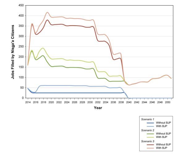
BJP = Brucejack Gold Mine Project
The proponent estimated the median employment income for Nisga'a workers working at the mine would range from $17,200 to $43,700 annually. Income depends on skill level and the length of the employment term. Business opportunities will occur mainly during the construction and operations phases of the Project. Depending on the proponent's approach to procurement, it is estimated that Nisga'a businesses could earn $30.2 million providing services to the Project such as transportation, road maintenance, catering and security. These opportunities could provide earnings to Nisga'a citizens, however many factors can limit business growth including capital, skilled labour, existing supplies and competition.
The employment and associated income of Nisga'a citizens will decline in the post-closure phase of the Project. The impact of this decline will depend on the workforce transition provisions included in the proponent's closure plan. Although business, earnings and investment activities would also decrease post-closure, the Nisga'a skilled labour force may have increased due to training and experience gained through working at the mine.
The Project may negatively affect Nisga'a Nation commercial natural resource activities, such as through increased competition for tourism and guiding in the high regional development scenario (Table 9). There may also be economic costs to the Nisga'a Lisims Government associated with monitoring social and cultural impacts that occur in Nisga'a communities as a result of the Project, which would reduce the ability of the Nisga'a Lisims Government to support the economic well-being of Nisga'a citizens not employed at the mine.
8.2.2 Potential effects to social well-being
There is a potential for Nisga'a citizens to return to Nisga'a Villages (in-migration) to satisfy the increase in labour demands from the Project. This may have an adverse effect on the availability of housing in Nisga'a Villages, and cause short-term negative social impacts associated with overcrowding and inadequate accommodations until additional housing is constructed. After mine closure, the out-migration of citizens from Nisga'a Villages may occur due to fewer available employment and business opportunities.
Community well-being may be impacted both positively and negatively by migration and population change, increases in disposable income, and work schedules. Nisga'a communities may experience negative social impacts related to family breakdown, substance abuse, gambling, crime and violence. However, more disposable income may allow for enhanced capacity to invest in housing improvements, ownership or expansion and the pursuit of post-secondary education and training. The loss of jobs and income post mine closure, and the associated out-migration from Nisga'a Villages may negatively impact the social well-being of Nisga'a citizens.
There is a potential for the Project to cause an increase the demand on medical, educational and social services as Nisga'a citizens move to Nisga'a Villages. It is anticipated that in the long term local services could be enhanced as an outcome of increased wealth in communities due to mine-related employment and income. Impacts to community services from the Project alone are considered to be negligible, however cumulative effects from the high and medium development scenarios (Table 9) could be adverse. This may result in a strain on the current level of services available.
Nisga'a workers on the Project will be exposed to the occupational health and safety risks associated with mining and large-scale construction, which may result in injury and the associated social impacts. Nisga'a workers may also experience environmental health risks from changes in noise levels, air quality, water quality and the contamination of country foods. These risks will be mitigated through the measures identified in Chapter 6.5 and further managed through the proponent's Human Health Monitoring Plan as required by the B.C. Environmental Assessment Office.
8.2.3 Potential effects to cultural well-being
The construction of the mine access road may increase access to resources and sites that are of cultural significance to Nisga'a citizens. This could result in both positive and negative effects, as this may provide Nisga'a citizens increased access to culturally important resources for hunting, gathering or fishing, while also increasing pressure on the given resource or site from both Nisga'a and non-Nisga'a citizens.
The potential modest influx of Nisga'a citizens to Nisga'a Villages may provide greater opportunity for them to participate in cultural activities and practices. Conversely, some Nisga'a citizens may choose to relocate to an urban locale (as defined in the Chapter 11 of the Treaty) such as Terrace, which may reduce the opportunity for them to engage in cultural practices.
Project work schedules may have the potential to conflict with cultural activities and harvesting practices, and may reduce Nisga'a mine worker participation in cultural community events and ceremonies. B.C. mine safety regulations require the use of English as the language of work, which may contribute to the cumulative loss of the Nisga'a language. There is a potential for the loss of transfer of traditional skills, practices, language and knowledge from elders if current and in-migrating citizens do not have time to engage in cultural activities. However, the increased economic well-being of Nisga'a mine workers may enable them to purchase equipment and supplies (e.g. boats, fishing equipment, firearms, all-terrain vehicles) used for cultural activities such as harvesting.
8.2.4 Mitigation of effects on the economic, social and cultural well-being of Nisga'a citizens
Paragraph 8(i) of Chapter 10 of the Nisga'a Final Agreement requires that:
"all environmental assessment processes referred to in the Nisga'a Final Agreement will, in addition to the requirements of applicable environmental assessment legislation:
- take into account any agreements between the project proponent and the Nisga'a Nation… concerning the effects of the project."
The proponent and the Nisga'a Nation announced on April 6, 2015 that they have entered into a Project Cooperation and Benefits Agreement in respect of the Project. The proponent asserts that the agreement and the mitigation identified in section 8.2.5 will mitigate the potential effects of the proposed project on the economic, social and cultural well-being of Nisga'a citizens to the satisfaction of the Nisga'a Nation.
Economic Well-being
The proponent asserts that the negative economic effects of the project, including those in respect of mine closure will be mitigated through the Project Cooperation and Benefits Agreement between the Nisga'a Nation and the proponent as well as through the proponent's closure plan and the Economic and Social Effects Management Plan required by the B.C. Environmental Assessment Office.
Social Well-being
Positive effects may include an enhanced individual and collective ability to invest in housing, education and services. Negative effects may include a supply gap for housing and services in Nisga'a Villages, and social impacts related to in-migration and increased disposable income. The proponent asserts that the negative social effects will be mitigated through the Project Cooperation and Benefits Agreement between the Nisga'a Nation and the proponent. Effects will also be mitigated by the proponent's human resource policies and employee assistance program that will take into account the needs of Nisga'a citizens employed at the mine and the Economic and Social Effects Management Plan required by the B.C. Environmental Assessment Office.
Cultural Well-being
Positive effects may include an increased economic ability to engage in cultural practices; negative effects may include a lack of time to do so, and reduced opportunities to use the Nisga'a language. The proponent asserts that the negative cultural effects of the Project will be mitigated by the Project Cooperation and Benefits Agreement between the Nisga'a Nation and the proponent as well as through the implementation of culturally aware work schedules for Nisga'a mine workers, and through the Heritage Management Plan required by the B.C. Environmental Assessment Office.
8.2.5 Agency conclusions on paragraph 8 (f) assessment
The Agency concludes that the Project would result in both positive and negative effects on the existing and future economic, social and cultural well-being of Nisga'a citizens who may be affected by the Project. Negative economic, social and cultural effects will be addressed through the Project Cooperation and Benefits Agreement between the Nisga'a Nation and the proponent as well as through the management plans proposed by the proponent and required by the B.C. Environmental Assessment Office.
9 Impacts on Potential or Established Aboriginal Rights
9.1 Potential or established Aboriginal rights in the project area
The Agency identified the following Aboriginal groups for consultation based on the location of the Project and the extent of its potential adverse impacts on potential or established Aboriginal or Treaty rights:
- Nisga'a Nation
- Tsetsaut/Skii km Lax Ha
- Tahltan Nation
- Métis Nation British Columbia
The Nisga'a Nation have an established Treaty with Canada and British Columbia that includes environmental assessment provisions that were discussed and assessed in Chapter 8 of this report. Consultation with the Nisga'a was conducted pursuant to the Treaty and was consistent with a "high depth" of consultation in relation to Treaty rights.
Tsetsaut/Skii km Lax Ha, Tahltan Nation and Métis Nation B.C. assert Aboriginal rights (and in some cases, title) in different geographic areas that overlap the Project. These assertions were collected from the federal government's knowledge of Aboriginal rights from previous interactions with each group, and from consultation activities during the course of the EA (see Appendix E).
Tsetsaut/Skii km Lax Ha
Tsetsaut/Skii km Lax Ha assert rights in a large traditional territory, as documented on multiple maps, that overlaps with the Project footprint including the mine, access road and transmission line, and smaller area known as the "Awiijii" (documented in maps submitted in the Delgamuukw litigation heard before the Supreme Court of Canada) where they assert both rights and title. The Awiijii area overlaps with part of the mine access road, and encompasses the west slope of the Oweegee/Strata Mountain Range that drains into the Bell-Irving watershed, including Bowser Lake and the Bowser River. Tsetsaut/Skii km Lax Ha assert the right to fish, hunt, trap and harvest.
Tahltan Nation
The Tahltan Nation is comprised of the Iskut First Nation and the Tahltan Indian Band, each with an elected chief. The Tahltan Central Council is the elected governing structure for the Tahltan Nation and represents them for issues related to Aboriginal rights and title. The southern boundary of their asserted traditional territory follows the north side of the Unuk River and Treaty Creek. The mine site is outside of Tahltan Nation asserted traditional territory, but the eastern portion of the access road near Highway 37 falls within it. The Tahltan Nation assert Aboriginal rights and title in their traditional territory, including the right to fish, hunt, trap and harvest.
Métis Nation British Columbia
Métis Nation B.C. is a consultative body representing chartered Métis communities in B.C. that asserts, on behalf of its membership, Métis rights and traditional uses throughout most of the province. The closest chartered communities to the project are the Northwest B.C. Métis Association (based out of Terrace) and the Tri-River Métis Association (based out of Smithers).
9.2 Potential adverse impacts of the Project on potential or established Aboriginal rights
The following sections describe the potential adverse impacts of the Project on potential or established Tsetsaut/Skii km Lax Ha, Tahltan Nation and Métis Nation B.C. Aboriginal rights in the geographical areas that overlap with Project components.
Tsetsaut/Skii km Lax Ha First Nation
Fishing
Tsetsaut/Skii km Lax Ha harvest fish species such as salmon, trout and Dolly Varden from fishing areas along the Bell-Irving River between Treaty Creek, Wildfire Creek and Todedada Lake and Gilbert Lake (Figure 2). The proponent identified environmental impacts from the Project such as the direct mortality, and the erosion and sedimentation effects on fish habitat which may impact Tsetsaut/Skii km Lax Ha's right to fishing. Impacts to fish and fish habitat are discussed in Chapter 6.2. The quality of the fishing experience may be affected by noise emanating from trucks, helicopter/aircraft, and blasting, and by visual disturbances from Project infrastructure. As a result, the enjoyment of the fishing experience will be reduced and may deter Aboriginal peoples from using their traditional fishing areas. No detectable change in fish abundance and distribution are expected.
Key issues raised by Tsetsaut/Skii km Lax Ha include concerns about tailings particles become suspended in the water column that would affect fish and fish habitat, that there is a lack of information regarding seasonal movement of fish in the proponent's EIS, and that non-Aboriginal or recreational fishermen will have increased access to traditional Tsetsaut/Skii km Lax Ha fishing areas from the Project. Tsetsaut/Skii km Lax Ha also requested that the proponent commit to on-going consultation and follow up with them regarding their access to- and use of fish. The Agency was satisfied with the proponent's responses to these comments, some of which commit to mitigation measures outlined below. With the application of these mitigation measures, the proponent has assessed the impact of the Project on the Tsetsaut/Skii km Lax Ha fishing rights to be low. The Agency concurs with the proponent's analysis.
Hunting and trapping
Tsetsaut/Skii km Lax Ha traditionally hunt moose, grizzly and black bear, mountain goat and birds such as ptarmigan, grouse and Canadian geese. Their hunting areas include the north side of Mount Anderson on Bowser Lake, and the Scott Creek and Todedada Creek valleys. In addition to hunting practices, Tsetsaut/Skii km Lax Ha trap American marten, beaver, wolf, marmot and wolverine using a number of traplines, one of which overlaps the eastern portion of the Brucejack access road.
The proponent has identified several impacts of the Project to Tsetsaut/Skii km Lax Ha hunting and trapping rights. This includes a decrease in the abundance of wildlife resources which in turn can increase the effort required to participate in hunting and trapping practices, an increase in mortality to wildlife from vehicle collisions along the access road, and impacts from recreational hunters using the access road. Changes in the distribution of wildlife can also increase the effort required to participate in hunting and trapping practices.
The Project will likely alter habitat use patterns because components and activities will both attract and deter harvested wildlife. Noise from the upgrade, operation and maintenance of the access road and aerodrome can disturb animals such moose and grizzly bear, and cause them to shift to other locations. This can have a subsequent effect on mountain goats. The access road can also attract wildlife because it acts as a corridor that facilitates movement. Road salt and food waste at project infrastructure will attract species such as American marten and may further alter habitat use. Similar to the impact to fishing, the quality of the hunting experience can be impacted by noise and visual impacts from project infrastructure.
The comments received from Tsetsaut/Skii km Lax Ha with regards to hunting and trapping focused on concerns about the potential for increased access of non-aboriginal or recreational hunters to the project area and the increases in American marten surrounding the camps becoming nuisance animals. They expressed dissatisfaction with the proponent's methodology to assess the abundance of wildlife, and were concerned about sensory disturbance to wildlife (access road, aerodrome, camps). The proponent indicated that the measures to mitigate impacts to wildlife would also mitigate impacts to Tsetsaut/Skii km Lax Ha hunting and trapping rights. The Agency concurs with this analysis.
Gathering
Tsetsaut/Skii km Lax Ha gather berries, mushrooms and medicinal plants within the Bell-Irving and Ningunsaw valleys, and around Bowser Lake. Other plant harvest areas include the east side of the Bell-Irving River north of Mehan Lake, Bell Creek, Oweegee Creek, Oweegee Lake and the upper Bowser River. The Brucejack access road passes through some of these gathering areas.
In the EIS review stage of the EA, Tsetsaut/Skii km Lax Ha commented that the methodology used to assess the impact to gathering rights underrepresented the amount of gathering they do. The proponent responded in a technical memo, explaining which valued components were used to conduct their evaluation, and showed that impacts to their gathering practices would be low. The Agency concurs with the proponent's analysis.
Tahltan Nation
Fishing
The Tahltan Nation traditionally harvests fish such as salmon and steelhead in the mid-Stikine, upper Nass and upper Skeena basins. None of these fishing locations overlap with the Project assessment area. The Tahltan Nation expressed concerns about cumulative impacts on fish and fish habitat in the Unuk River and the subsequent impacts on their right to fish. With the mitigation measures listed below, the proponent has assessed the impact of the Project on the Tahltan Nation's fishing rights to be negligible. The Agency concurs with the proponent's analysis.
Hunting and trapping
The Tahltan Nation traditionally hunt moose, caribou and mountain goat, and trap rabbit, beaver, groundhog and porcupine. The proponent did not include detailed analysis of the Project on the impacts to Tahltan Nation hunting and trapping rights in the Environmental Impact Statement. During development of the EIS Guidelines and the EIS review phase the Tahltan Nation raised concerns over increased access due to the Project, as well as impacts to their rights due to the east portion of the Brucejack access road that overlaps their traditional territory.
The proponent concludes that with the mitigation measures outlined below, the Project will have a low level impact on wildlife and access to the project area, therefore a low impact on the exercise of Tahltan Nation hunting and trapping rights. The Agency concurs with the proponent's analysis.
Gathering
The Tahltan Nation traditionally gather a number of different plants and berries for subsistence reasons including soapberries, blueberries, mushrooms, green vegetables, roots and medicinal plants. The Tahltan Nation did not raise any issues regarding their potential right to gather during the consultation process. The proponent has assessed the impact of the Project on Tahltan Nation gathering rights to be negligible. The Agency concurs with the proponent's analysis.
Métis Nation British Columbia
Métis Nation B.C. asserts fishing, hunting, trapping and gathering rights throughout much of B.C., including in and around the Project footprint. The group commented during development of the EIS Guidelines regarding the potential impacts of the Project on their asserted rights, and concerns regarding fish health, the abundance of wildlife, and their ability to access resources in the project area. The proponent did not include Métis Nation B.C. in its assessment of impacts to rights however it responded to their comments by explaining the assessment process of fish, wildlife and vegetation, and indicated that mitigation measures already proposed will eliminate any impacts to their rights. The Agency concludes the mitigation measures already proposed will prevent any impacts to Métis Nation B.C. fishing, hunting, trapping and gathering rights.
9.3 Proposed mitigation and accommodation measures
Based on the mitigation measures proposed by the proponent, the Agency is of the view that the implementation of the following key mitigation measures is required to ensure that the Project will not result in adverse impacts on potential or established Aboriginal rights.
Measures to Mitigate or Accommodate Impacts to Tsetsaut/Skii km Lax Ha Rights:
Chapters 6.2 (Fish and Fish Habitat), 6.3 (Migratory Birds) and 6.6 (Aboriginal peoples - Current Use of Lands and Resources for Traditional Purposes) of this report outline proposed measures to mitigate the effects to Tsetsaut/Skii km Lax Ha asserted rights to fishing, gathering, hunting and trapping. These measures include the proponent entering into an arrangement with Tsetsaut/Skii km Lax Ha to allow them to access fishing, hunting and gathering areas via the access road. In addition, the proponent will be required to develop management plans to ensure water quality, air quality, noise reduction and wildlife well-being will be required. Key among these measures includes those that apply directly to the access road to mitigate impacts to the abundance and distribution of wildlife that affect hunting rights.
The proponent has also indicated that it will negotiate an Impact Benefit Agreement with Tsetsaut/Skii km Lax Ha to further address adverse impacts to their rights.
Measures to Mitigate or Accommodate Impacts to Tahltan Nation Rights:
Chapters 6.2 (Fish and Fish Habitat), 6.3 (Migratory Birds) and 6.6 (Aboriginal peoples - Current Use of Lands and Resources for Traditional Purposes) of this report outline proposed measures that will mitigate the effects to Tahltan Nation asserted rights to fishing, gathering, hunting and trapping. Key among these measures includes those that apply directly to the access road to mitigate impacts to the abundance and distribution of wildlife that affect hunting rights.
Measures to Mitigate or Accommodate Impacts to Métis Nation British Columbia Rights:
Chapters 6.2 (Fish and Fish Habitat), 6.3 (Migratory Birds) and 6.6 (Aboriginal peoples - Current Use of Lands and Resources for Traditional Purposes) of this report outline proposed measures that will mitigate the effects to Métis Nation B.C. asserted rights to fishing, gathering, hunting and trapping.
9.4 Agency conclusion regarding impacts to potential or established Aboriginal rights
Based on the analysis of effects of the Project on Aboriginal peoples and the mitigation and accommodation measures outlined above, the Agency is satisfied that the potential impacts of the Project on potential or established Aboriginal rights have been adequately identified and appropriately mitigated or accommodated. The proponent has also indicated that negotiated an Impact Benefit Agreements with the Nisga'a Nation and intends to do so with Tsetsaut/Skii km Lax Ha to further address adverse impacts to their rights.
If the Minister of the Environment decides that the Project is not likely to cause significant adverse effects or if, in the event that adverse effects are considered significant but justified in the opinion of Governor in Council, the Minister will establish conditions in relation to the key mitigation measures. Conditions related to key mitigation measures that address effects on Aboriginal peoples would also support accommodation of potential or established Aboriginal rights.
10 Conclusions and Recommendations of the Agency
In determining whether or not the Project is likely to cause significant adverse environmental effects, the Agency took into account the Environmental Impact Statement and associated amendments, the views of the public, government agencies, and Aboriginal groups and the requirements of the follow-up and monitoring plans to be implemented by the proponent.
The environmental effects of the Project and their significance have been determined using assessment methods and analytical tools that reflect current accepted practices of environmental and socio-economic assessment practitioners, including consideration of potential accidents and malfunctions.
The Agency concludes that the Brucejack Gold Mine Project is not likely to cause significant adverse environmental effects, taking into account the implementation of the key mitigation measures described in this report.
Following public consultation on this draft EA Report, the Agency will take any comments received into account, finalize the EA report, and submit it to the Minister of the Environment. The Agency has proposed potential conditions in relation to mitigation measures for consideration by the Minister of the Environment. The Minister of the Environment will decide whether the Project is likely to cause significant adverse environmental effects, taking into account the implementation of mitigation measures. Following this decision (subject to Governor in Council justification, if necessary), the Minister will issue a Decision Statement to the proponent. If the Project is permitted to proceed, the Decision Statement will include conditions with which the proponent must comply.
11 References
Avian Power Line Interaction Committee. 2012 Reducing Avian Collisions with Power Lines: The State of the Art in 2012. Edison Electric Institute and APLIC. Washington, D.C.
British Columbia Ministry of Energy, Mines and Petroleum Resources. 2008. Health, Safety and Reclamation Code for Mines in British Columbia, 2008. Available from: http://www.empr.gov.bc.ca/MINING/HEALTHANDSAFETY/Pages/HSRC.aspx
British Columbia Ministry of Environment. 2014. B.C. Ambient Air Quality Objectives. Available from: http://www.bcairquality.ca/reports/pdfs/aqotable.pdf
British Columbia Ministry of Environment. 2014. Guidelines for Amphibian and Reptile Conservation during Urban and Rural Land Development in British Columbia. Available from http://www.env.gov.bc.ca/mwg-internal/de5fs23hu73ds/progress?id=23nQreoRAopAwWDzekbMfu3qIJcI8R7wPYgw0c10f9c,
British Columbia Ministry of Environment. 2004. Identified Wildlife Management Strategy. Available from http://www.env.gov.bc.ca/wld/frpa/iwms/speciesaccounts.html#mam
Canada Transportation Act: Ammonium Nitrate Storage Facilities Regulations. 2014a. Transport Canada. Available from: http://lawslois.justice.gc.ca/eng/regulations/C.R.C.,_c._1145/Available from: http://lawslois.justice.gc.ca/eng/regulations/C.R.C.,_c._1145/FullText.html
Canada Transportation Act: Transportation of Dangerous Goods Regulations. 2014b . Transport Canada. Available from: http://laws-lois.justice.gc.ca/eng/regulations/SOR-2001-286/
Canadian Council of Ministers of the Environment. 2001. Canadian Environmental Quality Guidelines. Available from: http://ceqg-rcqe.ccme.ca/en/index.html#void
Canadian Environmental Assessment Agency. 1994. Determining Whether a Project is Likely to Cause Significant Adverse Environmental Effects. Available from: www.canada.ca/en/environmental-assessment-agency/news/media-room/media-room-2015/determining-whether-designated-project-is-likely-cause-significant-adverse-environmental-effects-under-ceaa-2012.html
Canadian Environmental Assessment Agency. 2008. Operational Policy Statement – Assessing Cumulative Environmental Effects under the Canadian Environmental Assessment Act, 2012. Available from: www.canada.ca/en/environmental-assessment-agency/services/policy-guidance.html
Environment Canada. 2014. General Nesting Periods of Migratory Birds in Canada. Available from: https://www.ec.gc.ca/paom-itmb/default.asp?lang=En&n=4F39A78F-1
Environment Canada. 2015. Incidental Take of Migratory Birds in Canada. Available from: http://www.ec.gc.ca/paom-itmb/
Fisheries Act: Metal Mining Effluent Regulations. 2012. Fisheries and Oceans Canada. Available from: http://laws-lois.justice.gc.ca/eng/regulations/sor-2002-222/index.html
Health Canada. 2010. Federal Contaminated Site Risk Assessment in Canada, Part I: Guidance on Human Health Preliminary Quantitative Risk Assessment (PQRA), Version 2.0. Available from: http://www.hc-sc.gc.ca/ewh-semt/pubs/contamsite/part-partie_i/index-eng.php
Natural Resources Canada. 2010. Guidelines for Bulk Explosives Facilities Minimum Requirements. Available from: http://www.nrcan.gc.ca/explosives/publications/9925
12 Appendices
Appendix A: Environmental Effects Rating Criteria
The environmental effects rating criteria for duration, frequency and reversibility apply to all VCs for the Project and are listed in Table 10. The environmental effects rating criteria for magnitude, geographic extent and context are specific to each VC for the Project and are listed in Table 11. Table 12 defines the significance of adverse impacts based on Environmental Effects Rating Criteria.
|
Characteristic |
Environmental Effects Rating Criteria |
|---|---|
|
Duration: refers to the length of time an adverse impact may occur. |
Short-term: effect last approximately 1 year or less Medium-term: effect lasts between 1 – 11 years Long-term: effect lasts between 12 and 25 years Far future: effect lasts more than 25 years |
|
Frequency: refers to how often the adverse impact may occur. |
Once: the effect occurs once during any phase of the Project Sporadic: the effect occurs at sporadic or intermittent intervals during any phase of the Project Regular: the effect occurs on a regular basis during any phase of the Project Continuous: the effect occurs constantly during any phase of the Project |
|
Reversibility: refers to the probability that the adverse impact can be reversed. |
Reversible: will recover to baseline conditions before or after Project decommissioning Irreversible: permanent |
|
Characteristic |
Environmental Effects Rating Criteria |
|
VC – Outside Canada |
|
|---|---|
|
Magnitude: refers to the severity of the adverse impact. |
Negligible: there is no detectable change from baseline conditions Low: the magnitude of effect differs from the average value for baseline conditions, but is within the range of natural variation and well below a guideline value Medium: the magnitude of effect differs from the average value for baseline conditions and approaches the limits of natural variation, but below or equal to a guideline value High: the magnitude of effect differs from the average value for baseline conditions and exceeds a guideline value so that there will be a detectable change beyond the range of natural variation (i.e. change of state from baseline conditions) |
|
Geographic Extent: refers to the area that the adverse impact may cover. |
Local: effect is limited to the Project development area Landscape: effect extends beyond the Project footprint to a broader watershed area Regional: effect extends across the Regional Study Area Beyond regional: effect extends beyond state boundaries |
|
Context: refers to the type of environment that the adverse impact is likely to occur in. |
Low: the valued component is considered to have little to no unique attributes and/or there is high resilience to imposed stresses Neutral: the valued component is considered to have some unique attributes, and/or there is neutral (moderate) resilience to imposed stresses High: the valued component is considered to be unique, and/or there is low resilience to imposed stresses |
|
VC – Fish and Fish Habitat |
|
|
Magnitude: refers to the severity of the adverse impact. |
Negligible: there is no detectable change from baseline conditions Low: the magnitude of effect differs from the average value for baseline conditions, but is within the range of natural variation of the local population and well below a guideline value Medium: the magnitude of effect differs from the average value for baseline conditions and approaches the limits of natural variation of the local population, but is below or equal to a guideline value High: the magnitude of effect differs from the average value for baseline conditions and exceeds a guideline value so that there will be a detectable change beyond the range of natural variation of the local population (i.e. change of state from baseline conditions) |
|
Geographic Extent: refers to the area that the adverse impact may cover. |
Local: effect is limited to the Project development area Landscape: effect extends beyond the Project footprint to a broader watershed area Regional: effect extends across the Regional Study Area Beyond regional: effect extends beyond the Regional Study Area. Effect may cross provincial or state boundaries |
|
Context: refers to the type of environment that the adverse impact is likely to occur in. |
Low: the valued component is considered to have little to no unique attributes and/or there is high resilience to imposed stresses Neutral: the valued component is considered to have some unique attributes, and/or there is neutral (moderate) resilience to imposed stresses High: the valued component is considered to be unique, and/or there is low resilience to imposed stresses |
|
VC – Migratory Birds |
|
|
Magnitude: refers to the severity of the adverse impact. |
Negligible: There is no detectable change from baseline conditions Low: the magnitude of effect differs from the average value for baseline conditions, but is within the range of natural variation and well below a guideline value Medium: The magnitude of effect differs from the average value for baseline conditions and approaches the limits of natural variation, but below or equal to a guideline value High: The magnitude of effect differs from the average value for baseline conditions and exceeds a guideline value so that there will be a detectable change beyond the range of natural variation (i.e. change of state from baseline conditions) |
|
Geographic Extent: refers to the area that the adverse impact may cover. |
Local: effect is limited to the Project development area Landscape: effect extends beyond the Project footprint to a broader watershed area, but remains tied into the footprint and/or to individuals within that watershed Regional: effect extends across the Regional Study Area and/or the population of a species Beyond regional: effect extends beyond the Regional Study Area and/or population. Effect may cross provincial or state boundaries |
|
Context: refers to the type of environment that the adverse impact is likely to occur in. |
Low: the valued component is considered to have little to no unique attributes and/or there is high resilience to imposed stresses Neutral: the valued component is considered to have some unique attributes, and/or there is neutral (moderate) resilience to imposed stresses High: the valued component is considered to be unique, and/or there is low resilience to imposed stresses |
|
VC – Species at Risk |
|
|
Magnitude: refers to the severity of the adverse impact. |
Negligible: there is no detectable change from baseline conditions Low: the magnitude of effect differs from the average value for baseline conditions, but is within the range of natural variation and well below a guideline value Medium: the magnitude of effect differs from the average value for baseline conditions and approaches the limits of natural variation, but below or equal to a guideline value High: the magnitude of effect differs from the average value for baseline conditions and exceeds a guideline value so that there will be a detectable change beyond the range of natural variation (i.e. change of state from baseline conditions) |
|
Geographic Extent: refers to the area that the adverse impact may cover. |
Local: effect is limited to the Project development area Landscape: effect extends beyond the Project footprint to a broader watershed area, but remains tied into the footprint and/or to individuals within that watershed Regional: effect extends across the Regional Study Area and/or the population of a species Beyond regional: effect extends beyond the Regional Study Area and/or population. Effect may cross provincial or state boundaries |
|
Context: refers to the type of environment that the adverse impact is likely to occur in. |
Low: the valued component is considered to have little to no unique attributes and/or there is high resilience to imposed stresses Neutral: the valued component is considered to have some unique attributes, and/or there is neutral (moderate) resilience to imposed stresses High: the valued component is considered to be unique, and/or there is low resilience to imposed stresses |
|
VC – Aboriginal People: Health Conditions and Socio-economic Conditions |
|
|
Magnitude: refers to the severity of the adverse impact. |
Negligible: there is a negligible level of disturbance to existing health and socio-economic conditions Low: there is a low level of disturbance to existing socio-economic conditions and/or a complete exposure pathway to affect health risk, with exposures below health?based guidelines. Residual effects offset by mitigation and management options Medium: there is a moderate level of disturbance to existing socio-economic conditions and/or a complete exposure pathway to affect health risk with exposures below, but nearing health-based guidelines. Residual effect will still persist with mitigation and management High: there is a high level of disturbance to existing socio-economic conditions and/or a complete exposure pathway to affect health risk with exposures above health?based guidelines |
|
Geographic Extent: refers to the area that the adverse impact may cover. |
Local: effect is limited to the Project development area Landscape: effect extends beyond the Project development area to the Local Study Area Regional: effect extends across the Regional Study Area Beyond Regional: effect extends beyond the Regional Study Area. Effect may cross provincial or state boundaries |
|
Context: refers to the type of environment that the adverse impact is likely to occur in. |
Low: high level of existing disturbance Moderate: moderate level of existing disturbance High: low level of existing disturbance |
|
VC – Aboriginal People: Current Use of Lands and Resources |
|
|
Magnitude: refers to the severity of the adverse impact. |
Negligible: there is no detectable change from baseline conditions Low: very small detectable change from baseline; no exacerbation of existing conditions. Little to no alteration of behaviour is required to carry out the current Aboriginal use Medium: varies from baseline and may result in noticeable changes to Current Aboriginal Use. At least some behaviours are altered at least some of the time while carrying out the Current Aboriginal Use High: varies from baseline to a high degree. The current Aboriginal use can no longer be carried out in preferred locations and ways |
|
Geographic Extent: refers to the area that the adverse impact may cover. |
Local: effect is limited to the Project development area Landscape: effect extends beyond the Project footprint to a broader watershed area Regional: effect extends across the Regional Study Area Beyond regional: effect extends beyond the Regional Study Area. Effect may cross provincial or state boundaries |
|
Context: refers to the type of environment that the adverse impact is likely to occur in. |
Low: low vulnerability to change caused by the Project. Aboriginal use close to historic levels, little interference with underlying conditions, little interference with opportunities to engage in use as preferred, high resilience to change Moderate: moderate vulnerability to change caused by the Project. Aboriginal use moderately diminished from historical levels, moderate interference with underlying conditions, and moderate interference with opportunities to engage in as preferred, moderate resilience to change High: high vulnerability to change caused by the Project. Aboriginal use highly diminished from historical levels, high interference with underlying conditions, high interference with opportunities to engage in use as preferred, low resilience to change |
|
VC – Aboriginal People: Physical or Cultural Heritage, and Effects on Historical, Paleontological or Archaeological Sites or Structures |
|
|
Magnitude: refers to the severity of the adverse impact. |
Negligible: there is no detectable change from baseline conditions Low: effect is detectable but is limited to small portions of CMTs and/or other archaeological or heritage sites of low significance or to portions of archaeological or heritage sites already substantially disturbed by previous developments Medium: affects small but intact portions of archaeological or heritage sites of moderate or high significance, or substantial, intact portions of archaeological or heritage sites of low significance High: affects substantial, intact portions of one or more sites of moderate or high significance |
|
Geographic Extent: refers to the area that the adverse impact may cover. |
Local: limited to the Project development area Landscape: effect extends beyond the Project development area to the Local Study Area Regional: effect extends across the Regional Study Area Beyond regional: effect extends beyond the Regional Study Area. Effect may cross provincial or state boundaries |
|
Context: refers to the type of environment that the adverse impact is likely to occur in. |
Undisturbed: there are no existing disturbances within the Project development area Disturbed: there are existing disturbances within the Project development area |
The following describes the criteria for determining the significance of adverse impacts based on frequency, reversibility, magnitude, context, geographic extent, duration, probability and confidence.
|
Significance |
Criteria |
|---|---|
|
Minor (Not Significant) |
Residual effects are low in magnitude, local in geographical extent, have a short or medium term duration, are reversible, have low context and occur intermittently, if at all. There is a high level of confidence in the conclusions. The effects on the VC (at a population or species level) are indistinguishable from background conditions. Follow up monitoring of these effects may be required. |
|
Moderate (Not Significant) |
Residual effects are medium in magnitude, have a local, landscape, or regional geographic extent, are short term to chronic (i.e. may persist into the far future), are reversible, have moderate context and occur at all frequencies. Residual effects on VCs are distinguishable at the population, community, and/or ecosystem level. Confidence in the conclusions is medium or low. Follow up monitoring of these effects may be required. |
|
Major (Significant) |
Residual effects are high in magnitude, have a regional or beyond regional geographic extent, are chronic (i.e. persist into the far future), are irreversible, have high context and occur at all frequencies. Residual effects on VCs are consequential (i.e. structural and functional changes in populations, communities and ecosystems are predicted) Probability of the effect occurring is medium or high. Confidence in the conclusions can be high, medium, or low. Follow-up monitoring is required. |
Appendix B: Summary of Environmental Effects Assessment
|
Residual effect |
Predicted degree of effect after mitigation |
||||||
|---|---|---|---|---|---|---|---|
|
Magnitude |
Extent |
Duration |
Frequency |
Reversibility |
Context |
Significance |
|
|
VC – Outside Canada |
|||||||
|
Negligible |
Local |
Long-term – life of Project |
Continuous |
Reversible |
Low |
After implementation of mitigation measures, residual effects are anticipated to be minor |
|
VC – Fish and fish habitat |
|||||||
|
Bowser River Watershed: Residual effects are expected to be minor, and would only result from the improper implementation of mitigation measures during the upgrade of the access road, and from accidents and malfunctions during operation. Residual effects on in-stream and riparian habitat are not anticipated. |
Low |
Landscape – 73 kilometre access road |
Short-term – road upgrades, accidents |
Sporadic |
Reversible |
Moderate – the mine road (including key bridges) was built prior to the Project being proposed |
After implementation of mitigation measures, residual effects are anticipated to be minor |
|
Unuk River Watershed: Residual effects to water quality could occur if there is a major accident or malfunction in the planned tailings paste design, water treatment facility and turbidity curtain. Since Brucejack Creek only contributes approx. 1% to the overall volume of the Sulphurets system, such an event is unlikely to result in measureable residual effects on fish habitat 20 kilometres downstream in Sulphurets Creek. |
Negligible |
Landscape – Brucejack Creek contributes 1% of flow to Sulphurets Creek, which already has high natural levels of dissolved metals |
Long-term – life of Project |
Continuous |
Reversible |
Low – Sulphurets Creek only supports fish at below the waterfall, naturally high selenium levels |
After implementation of mitigation measures, residual effects are anticipated to be minor |
|
VC – Migratory birds |
|||||||
|
No residual effects are predicted on individual migratory birds. Vegetation clearing and sensory disturbances will cause some residual effects as the entire Local Study Area is considered to be migratory bird habitat. |
Low |
Local |
Long-term – life of Project |
Continuous – sensory disturbance Once – vegetation clearing |
Reversible |
Low |
After implementation of mitigation measures, residual effects are anticipated to be minor |
|
VC – Species at risk |
|||||||
|
Western Toad: Residual effects on western toad populations are predicted to occur as a result of direct mortality due to the proximity of the access road to toad breeding sites. |
Low – habitat degradation Medium – vehicle collision |
Local – limited to the access road and a 300m buffer |
Long-term – life of Project |
Once – habitat degradation Sporadic – vehicle collisions |
Reversible – if population is maintained until closure |
High – toads are less able to adapt and relocate to alternate habitat |
After implementation of mitigation measures, residual effects are anticipated to be minor |
|
Other Species at Risk (Bats and Birds): Residual effects are predicted to occur as a result of direct mortality, habitat loss and degradation. |
Low |
Local – limited to the access road and a 300m buffer |
Long-term – life of Project |
Once – habitat degradation Sporadic – vehicle collisions |
Reversible – if population is maintained until closure |
High – critical habitat is common throughout the region |
After implementation of mitigation measures, residual effects are anticipated to be minor |
|
VC – Aboriginal people – current use of lands and resources for traditional purposes |
|||||||
|
Residual effects are not predicted in relation to fishing practices of Aboriginal people. There is the potential for residual effects to occur on hunting and trapping practices as a result of a change in the location, timing and availability of wildlife, and a displacement of hunting within the Project area. |
Moderate |
Landscape |
Long-term – life of Project |
Continuous |
Reversible |
Moderate |
After implementation of mitigation measures, residual effects are anticipated to be moderate |
|
VC – Aboriginal people – health and socio-economic conditions |
|||||||
|
Residual noise effects will occur including exceedance of noise guidelines for sleep disturbance and speech interference. |
High |
Landscape |
Medium-term |
Regular |
Reversible |
Moderate |
After implementation of mitigation measures, residual effects are anticipated to be moderate |
|
Residual effects to air quality will occur due to Project-related emissions and fugitive dust. |
Moderate |
Landscape |
Long-term |
Regular |
Reversible |
Moderate |
After implementation of mitigation measures, residual effects are anticipated to be moderate |
|
Residual effects to water quality will occur due to the localized introduction of contaminants or suspended solids, or from Project-related spills/leaks. |
Low |
Local |
Short-term |
Sporadic |
Reversible |
Moderate |
After implementation of mitigation measures, residual effects are anticipated to be minor |
|
Residual labour market effects will occur to Aboriginal peoples by causing changes related to employment and labour participation, increasing competition for labour and wage inflation, and decreasing employment at closure. |
Moderate |
Local |
Medium-term Short term – employment at closure |
Continuous Once for employment at closure |
Reversible |
Moderate |
After implementation of mitigation measures, residual effects are anticipated to be moderate |
|
During the Operations phase of the Project education and skills development for Aboriginal groups are expected to increase due to on-the-job training, work experience and skill development for Project workers |
Moderate |
Regional |
Short-term |
Sporadic |
Reversible |
Moderate |
After implementation of mitigation measures, residual effects are anticipated to be minor |
|
In-migration of workers for the Project is expected to have an adverse effect due to an increased demand on a limited housing and infrastructure supply during the construction phase. Housing supply is expected to increase during the operations phase. |
Low |
Regional |
Long term |
Sporadic |
Reversible |
Moderate |
After implementation of mitigation measures, residual effects are anticipated to be minor |
|
In-migration of workers for the Project is expected to increase the demand for health and social services during the construction phase. However, these services are expected to adapt to the increased demand during the Operations and Closure phases of the Project. |
Moderate |
Regional |
Short-term |
Sporadic |
Reversible |
Moderate |
After implementation of mitigation measures, residual effects are anticipated to be minor |
|
VC – Aboriginal people – physical or cultural heritage, and effects on historical, paleontological or archaeological sites or structures |
|||||||
|
Residual effects are expected to be negligible. |
Low |
Local |
Long-term |
Sporadic |
Reversible |
Moderate |
After implementation of mitigation measures, residual effects are anticipated to be minor |
Appendix C: List of key mitigation measures, monitoring and follow-up identified by the Agency
This appendix lists key mitigation measures and follow-up program requirements identified by the Agency for consideration by the Minister of the Environment in preparing conditions as part of the decision statement.
|
Valued Component |
Mitigation Measures |
|---|---|
|
Effects identified under subsection 5(1) of the Act |
|
|
Outside Canada |
Mitigation measures
Monitoring and follow-up activities
|
|
Fish and fish habitat |
Mitigation measures
Monitoring and follow-up activities
|
|
Migratory birds |
Mitigation measures
|
|
Aboriginal people - health and socio-economic conditions |
Mitigation measures
Monitoring and follow-up activities
|
|
Aboriginal people – current use of lands and resources for traditional purposes |
Mitigation measures
Monitoring and follow-up activities
|
|
Aboriginal people – physical or cultural heritage and effects on historical, archaeological, paleontological or archaeological sites or structures of Aboriginal groups |
Mitigation measures
|
|
Other measures – Nisga'a Final Agreement |
|
|
Nisga'a Nation |
Mitigation measures Access:
Monitoring and Follow-up Cultural Artifacts and Heritage :
Recommendations Economic Well-being:
Social Well-being:
Cultural Well-being:
|
Appendix D: Mitigation measures, monitoring and follow-up proposed by the Proponent
The proponent has committed to implementing a number of mitigation measures to reduce adverse effects from the Project. The following table presents the mitigation measures committed to by the proponent that are relevant to the federal EA process. Note that the Agency will not recommend that all of these commitments form conditions of EA approval. This table is provided for informational purposes only.
|
Mitigation Measures |
|---|
|
Valued Component - Outside Canada |
|
Mitigation measures Flow change:
Water quality changes in the Unuk River:
Monitoring and Follow-up activities
|
|
Valued Component - Fish and fish habitat |
|
Mitigation measures Mitigation for increased fishing:
Mitigation for erosion and sedimentation:
Mitigation for change in water quality:
Mitigation related to petroleum products:
Mitigation for habitat loss:
Mitigation for process chemicals:
Monitoring and Follow-up activities
|
|
Valued Component - Migratory birds |
|
Mitigation measures Sensory disturbance:
Direct mortality, and habitat loss or alternation:
Attractants:
Monitoring and Follow-up activities
|
|
Valued Component - Species at risk |
|
Mitigation measures Habitat loss and alteration:
Sensory disturbance:
Disruption of movement:
Mortality:
Mortality from non-project activities:
Attractants:
Monitoring and Follow-up activities
|
|
Aboriginal people - health and socio-economic conditions |
|
Mitigation measures Measures for changes to employment/labour participation of vulnerable groups, for increased competition for labour/wage inflation, and for education, skills development and training:
Mitigation for decrease in employment at Project closure:
Mitigation measures for community infrastructure, services and housing:
Mitigation measures for noise – human health:
Mitigation measures for air quality – human health:
Mitigation measures for drinking water quality – human health:
|
|
Aboriginal people – current use of lands and resources for traditional purposes |
|
Mitigation measures Hunting opportunities and practices:
Gathering Opportunities and Practices:
Monitoring and Follow-up activities
|
|
Aboriginal people – physical or cultural heritage and effects on historical, archaeological, paleontological or archaeological sites or structures |
|
Mitigation measures Mitigation measures for protected archaeological sites HbTm-1 and HcTk-1:
Mitigation measures for as-yet-unknown archaeological sites:
Monitoring and Follow-up activities
|
|
Nisga'a Final Agreement |
|
Mitigation measures Fish and Fish Habitat:
Wildlife and Migratory Birds
Prevent effects due to attractants, prevent access to infrastructure by birds, remove nesting material prior to egg-laying Economic Well-being:
Social Well-being:
Cultural Well-being:
|
Appendix E: Aboriginal Issues Tracking Table
|
Group |
Comment or Concern |
Summary of Proponent's Response |
Agency Response |
|---|---|---|---|
|
Scope of the EA |
|||
|
Nisga'a Nation, Tahltan Nation |
Concerned that the construction of the mine access road was not included in the EA. |
NA – The Agency determines the scope of the assessment |
Mining Exploration is not a designated activity requiring an EA under CEAA 2012; therefore no infrastructure associated with exploration such as an exploration access road would be examined under CEAA 2012. The EA includes an assessment of the upgrade, operation and maintenance of the mine access road. |
|
Nisga'a Nation |
Concerned about environmental impacts from increased traffic along Hwy 37. |
NA – The Agency determines the scope of the assessment |
Highway 37 is not included in the scope of the assessment, because increases in vehicular traffic would be negligible (6 to 10 trucks per day). |
|
Nisga'a Nation and Tsetsaut/Skii km Lax Ha |
Scope of the assessment should include impacts of the Project on the Knipple glacier. |
NA – The Agency determines the scope of the assessment |
The EA includes the assessment of interactions between glaciers and the Project, including impacts to the Knipple Glacier as they relate to accidents and malfunctions, and effects of the environment on the Project. |
|
Nisga'a Nation, Tsetsaut/Skii km Lax Ha, Métis Nation B.C. |
Concerned about impacts from construction and operation of the mine access road on moose, mountain goat, grizzly bear, migratory birds, fish, fish habitat and guide angling opportunities. |
NA – The Agency determines the scope of the assessment |
The EA includes an assessment of the upgrade, operation and maintenance of the mine access road. Impacts to effects listed under section 5 of CEAA 2012 were considered. This included migratory birds, moose, mountain goat, grizzly bear, fish, fish habitat, and impacts to guide angling opportunities as they relate to the current use of lands and resources for traditional purposes. |
|
Tsetsaut/Skii km Lax Ha |
Concerned that unidentified Culturally Modified Trees exist along the access road and want them documented. |
NA – The Agency determines the scope of the assessment |
The EA report includes a condition which will require that a Chance Find Protocol be developed in consultation with Tsetsaut/Skii km Lax Ha , and will include a process to document any new Culturally Modified Trees found in the Project area. |
|
Tsetsaut/Skii km Lax Ha |
Concerned about the health and economic effects as a result of decreased availability of traditional resources such as country foods. |
NA – The Agency determines the scope of the assessment |
The EA includes the assessment of impacts to Aboriginal health and socio-economic well-being, as well as to current use of land and resources for traditional purposes. |
|
Nisga'a Final Agreement |
|||
|
Nisga'a Nation |
Concerned that "Current Fishing" for Nisga'a citizens was limited to sockeye and chinook, and noted that they also fish for Coho and Steelhead from Bowser Lake and the Bell-Irving River. |
Pretium acknowledges Nisga'a citizens fish for Coho and Steelhead populations from Bowser Lake, and that Nisga'a citizens also harvest Bell-Irving stocks. Pretium further acknowledges the importance of the Bell Irving and Bowser systems to Nisga'a Treaty interests in fish. |
The Agency is satisfied with the proponent's response, and that impacts to fish used by Nisga'a citizens are appropriately assessed. The EA includes the assessment of impacts to fishing and current use of land and resources for traditional purposes under CEAA 2012. |
|
Nisga'a Nation |
Noted that they do not need to identify fishing/hunting/trapping areas used by Nisga'a citizens, as their treaty rights extend to the entire Nass Area. The assessment needs to focus on potential impacts to Treaty rights and interests, and not traditional/contemporary uses. |
Pretium acknowledges Nisga'a citizens' treaty rights to fish and to aquatic plants, and that these extend to the entire Nass Area. Acknowledge that the health of migratory fish stocks is paramount to the preservation of this right. Pretium re-iterates their understanding of Nisga'a wildlife harvesting rights, wildlife allocation and designated/non-designated species outlined in the Treaty, and points to Chapter 27 where this information is largely contained. |
The EA includes an assessment of potential impacts to fishing, hunting and trapping under CEAA 2012, and the impacts to Treaty rights have been assessed. |
|
Nisga'a Nation |
The temporal boundary for the assessment of potential environmental effects on Nisga'a 8(e) interests is a minimum of three years post-closure of the mine. This minimum boundary is insufficient and should be increased. |
The primary activity during the Post-Closure phase will be ongoing monitoring, which is assumed to occur for the first five years of the period. This could be extended depending on initial results. It is expected that once water quality in Brucejack Lake and Creek return to background levels or consistently meet receiving environment water quality objectives, that monitoring would cease. It is expected that water quality within Brucejack Lake and in the immediately receiving environment will return to baseline conditions within several years following cessation of mining operations. |
The Agency is satisfied with the proponent's response, that additional monitoring time can be added as required in order to ensure water quality in Brucejack Lake and Creek return to background levels. Monitoring results will be submitted to the Agency throughout the post-closure phase. |
|
Fish and Fish Habitat |
|||
|
Tsetsaut/Skii km Lax Ha |
Concerned that tailings particles could be re-suspended as a result of glacial recession, climate change, and during the early and late operation phases as lake depth changes. This in turn could affect surface water quality, aquatic resources, and fish and fish habitat Unuk River watershed. |
Potential effects of climate change on hydrology are assessed in the EIS. Streamflow changes are expected in Brucejack Creek after year 2050, increasing by 12% over 90 years. However, modelling of tailings re-suspension in Brucejack Lake indicated that the potential for tailings particle migration is strongly determined by the physical size of the particles and the inputs of high salinity water into Brucejack Lake, and not necessarily the inputs of surface water. Modelling results indicate that if the tailings particles remain above 5 microns in size, re-suspension of tailings particles into the water column is not expected. The residual effects identified on surface water quality, aquatic resources, fish and fish habitat in the Application/EIS considered this result. |
The Agency has assessed impacts of the environment on the project, including impacts of the project on surface water quality. Based on its analysis, the Agency concludes that no significant residual effects will occur, after the implementation of key mitigation measures and conditions. Key conditions include: (1) capture and treat contact water and effluent prior to discharge to the environment; (2) immobilize tailings at the bottom of the lake to prevent heavy metals and contaminants from degrading water quality; (3) using turbidity curtains at the outfall of Brucejack Lake into Brucejack Creek; and (4) control acid rock drainage and metal leaching so that all effluent and passive outflow complies with the Fisheries Act and any site-specific water quality objectives set by B.C. |
|
Tsetsaut/Skii km Lax Ha |
Requested an assessment of seasonal movements of fish species and possible interaction with Project activities. |
Seasonal movements of fish within the baseline and regional study areas are summarized in the EIS in a fish life history periodicity table (Table 15.3-1). |
The Agency is satisfied that the proponent has sufficiently characterized impacts to fish and fish habitat. The Agency's analysis concludes that after key mitigation measures and conditions are applied to surface water quality, to fish and fish habitat, and to the current use of land and resources for traditional purposes, no significant adverse effects to fish and fish habitat will occur. |
|
Métis Nation B.C. |
Concerned about water quality impacts to fish and fish habitat and their subsequent ability to harvest trout and salmon in the Unuk and Bowser Rivers. |
Water quality concerns are restricted to the Brucejack Creek watershed and downstream receiving environment. Water quality effects are not expected to be experienced in fish bearing waters downstream of Brucejack Lake. Within the Bowser River watershed, there are no effluent discharges to the surface water bodies and potential effects to water quality are anticipated to be negligible. For the Brucejack Creek watershed and downstream receiving environment, if a predicted metal concentration was greater than baseline conditions or naturally-occurring guideline exceedances, the parameter was considered a possible Project-related chemical of particular concern (COPC) and retained for further assessment. The significance determination considers factors such as uncertainty in guideline limits (e.g., due to safety factors or the underlying studies used to derive the guidelines), the sensitivity of potential receptors in the receiving environment, or other Project specific information (e.g., uncertainty in the predicted concentrations or other factors that may affect the metal concentration or toxicity). Water quality was modelled at Site BJ1, 200 m downstream of Brucejack Lake. At this site, a total of four COPCs (arsenic, zinc, chromium, and total aluminium) were predicted to exceed baseline conditions. These fours COPCs (or any other Project related metal) due to the Project are not expected to result in the potential for residual effects in the fish-bearing reach of Sulphurets Creek (Site SC-3) or the Unuk River, because the stream discharge rate in the lower reach of Sulphurets Creek are an order of magnitude larger than Brucejack Creek . As a result the COPC concentrations would be greatly reduced to Hazard Quotients (HQs) less than 1.0 By the time a COPC reaches fish-bearing waters, 21 km downstream of BJ1, the COPC concentration would be greatly reduced. Based upon these results, the project related water quality effects were considered not-significant. The Aquatic Effects Monitoring Plan is described in the EIS and will be further developed to support Mines Act and Environmental Management Act permits for the project to the satisfaction of the B.C. Ministry of Environment. |
Based on the information available to the Agency on land uses in the Project area, the Agency is satisfied that proposed mitigation measures and conditions will ensure that the Project will not cause negative impacts to surface water quality, fish and fish habitat, fish health, and the ability of Aboriginal groups to harvest fish. |
|
Wildlife |
|||
|
Tsetsaut/Skii km Lax Ha |
Concern that the methodology used to assess abundance of grizzly bear, moose, and mountain goats underestimates of their presence and therefore impacts to them. |
Grizzly: The assumption used for the purposes of the effects assessment of disruption of movement on grizzly bears was that traffic would be evenly distributed over a 24-hr period. If traffic was mainly during a 12-hour period, as suggested by the reviewer, than an average of approximately 7.2 Vehicles Per Hour (VPH) may occur along the access road, which is still below the threshold of 10 VPH which was identified for effects on grizzly bears. Disruption of movement is evaluated as having a residual effect. Effects of fixed wing disturbance will largely be eliminated due to mitigation measures such as minimum flight elevations, leaving vehicle noise as the principal source of noise. Therefore, the number of home ranges affected by road noise would equal 0.13 female grizzly bears if those ranges overlapped all functional habitat. Therefore, the conclusions of the EA remain the same. Moose: The Wildlife Management and Monitoring Plan (WMMP) includes provisions for timing windows to clear vegetation outside of sensitive periods for wildlife, including moose, during winter (Nov-May) and calving (April-July). If ground clearing cannot be conducted outside of this period, then pre-construction surveys will be conducted prior to on-site works. The WMMP plan will be developed in further detail during the permitting stage. Updated methods will be part of the final WMMP including ground-based pre-clearing surveys during any vegetation clearing/felling. Mountain Goat: The mitigation for mountain goat timing windows within 500 m of Ungulate Winter Ranges will be limited to the commitment that clearing activities will not occur within 500 m of UWR U-6-002 areas from November 1 to June 14, unless an exemption is granted. |
The Agency has assessed the potential impacts of the Project on grizzly, moose and mountain goat, as well as on the current use of lands and resources for traditional purposes. The Agency concludes that with the implementation of key mitigation measures and conditions, no significant adverse effects to these species will occur. Key conditions include prohibiting employees and contractors from hunting, trapping or fishing; preventing public access to the area by way of the Mine Access Road; and developing management plans in consultation with the Aboriginal people. |
|
Tsetsaut/Skii km Lax Ha |
Concerned that sensory disturbance occurs over a large area, and will therefore affect a large number of individual grizzly bears. The EIS does not predict residual effects because the area of habitat effects is divided by the home range of the species, potentially underestimating impacts. |
The Brucejack Regional Study Area straddles three provincial Grizzly Bear Population Units (GBPUs) and represents 8.2% of the area of these GBPUs. Considering the proportion of each GBPU that is contained in the Regional Study Area and relating that proportion to the estimated population size of grizzly bears in each GBPU, it is expected that the Brucejack Regional Study Area would support up to 108 grizzly bears (from baseline report), more than the 37 detected during the Deoxyribonucleic Acid Baseline Study. This accounts for 2 to 7% of the estimated 1,511 grizzly bears in the combined GBPUs. The effect of indirect mortality was assessed as a residual effect as a precautionary approach. Mitigation and management of the access road will result in the road being closed to all non-project personnel, including hunters. Therefore, no increase in hunting (indirect mortality) is expected for grizzly bears, resulting in the predicted residual effect being not significant for the grizzly bear population in the Regional Study Area. |
The Agency has assessed the potential impacts of the Project on grizzly bears. The Agency concludes that with the implementation of key mitigation measures and conditions, no significant adverse effects to this species will occur. Key conditions include: prohibiting employees and contractors from hunting, trapping or fishing; preventing public access to the area by way of the Mine Access Road; and developing management plans for noise and transportation in consultation with the Tsetsaut/Skii km Lax Ha. |
|
Tsetsaut/Skii km Lax Ha |
Concerned that mountain goats could be negatively affected by the aerodrome; that the mine site serves as an attractant for martens, which are important for commercial and ceremonial purposes. |
Pretium acknowledges that a low magnitude, non-significant effect to mountain goats may occur as a result of sensory disturbance related to increased noise levels, which was assessed in the EIS. It is expected that less than 10% of the mountain goat population in the region would be exposed to increased noise levels due to both helicopter and fixed wing aircraft traffic. Specific to the aerodrome, it is expected there will be 5 to 10 flights per week during Construction and 6 to 7 flights per week in the Operation phase. |
The Agency has assessed the potential impacts of the Project on wildlife as it relates to the current use of land and resources for traditional purposes. Key mitigation measures and conditions will be implemented to ensure that no significant adverse environmental effects occur including assigned flight path, and the use of low noise-emitting equipment. |
|
Tsetsaut/Skii km Lax Ha |
Concerned that the mine site serves as an attractant for American marten which are important for commercial and ceremonial purposes |
It is acknowledged that marten will be attracted to the camp areas. At the request of the Tsetsaut/Skii km Lax Ha, Standard Operating Procedures were developed during the exploration phase related to camp waste management and animal exclusion specific to addressing this concern. Similar procedures will be in place for the construction and operation phases of the project. |
The Agency has assessed the potential impacts of the Project on American marten as it relates to the current use of land and resources for traditional purposes and is satisfied that mitigation measures such as storing attractants (garbage and food waste) will ensure that no significant adverse environmental effects occur. |
|
Tsetsaut/Skii km Lax Ha |
Concerned that the access road has resulted in a decreased number of grizzlies (due to easier hunting and predation opportunities) and moose. Moose are used for trading, ceremonial, food and commercial purposes. |
Pretium is aware of potential unauthorized use along the access road by a guide outfitter. However, Pretium is not aware of any mortality to grizzly bears or moose that has occurred as a result of this. Nonetheless, the access road will continue to be restricted and instances of unauthorized use will be immediately reported to the Mine Manager. Procedures related to this are included in traffic management and wildlife management plans to be implemented through construction, operation, and closure phases of the project. |
The EA includes an assessment of the upgrade, operation and maintenance of the mine access road. The Agency has assessed the potential impacts of the Project on grizzly and moose as it relates to the current use of land and resources for traditional purposes and is satisfied that key mitigation measures and conditions such as imposing speed limits and leaving gaps in snow banks will ensure that no significant adverse environmental effects occur. |
|
Current Use of Lands and Resources for Traditional Purposes |
|||
|
Tsetsaut/Skii km Lax Ha |
Concerned that the Visual Quality Study did not take into account hunting, fishing, habitation, and travel routes in their assessment. This affects the validity of the baseline data on land use activities and therefore potential conclusions on the assessment of land use for traditional purposes (it scoped all but commercial guiding out of the assessment). |
A technical memo dated November 21, 2014 has responded to the question on viewshed analysis and baseline data on land use activities. Some Project components may be visible from Tsetsaut/Skii km Lax Ha current and traditional use areas and sites during construction and operation, resulting in a change in the quality of experience of the natural environment for Tsetsaut/Skii km Lax Ha harvesters. This may affect enjoyment of these areas, or discourage use. No current and traditional use areas and sites in the Mine Site Area were identified. The Brucejack Access Road is an existing road and the road is mostly shielded by vegetation, which helps mitigate potential visual quality effects on land users. The new 55 kilometres transmission line will follow the Granduc Access Road for a portion of its length, helping to minimize potential visual quality effects on land users. No new roads will be constructed, and single-steel monopole towers with helicopter placement will be used. Finally, there will be limited tree clearing with no removal where permissible. Pretium commits to further discussions with Tsetsaut/Skii km Lax Ha regarding Current Aboriginal Use. |
The Agency has assessed potential impacts of the Project on current use of land and resources for traditional purposes, including visual impacts of the Project. After the implementation of key mitigation measures, there will be some residual adverse effects from visual impacts, however they are not expected to be significant on current use of land and resources for traditional purposes. |
|
Tsetsaut/Skii km Lax Ha |
Concerned that the proponent relied too heavily on the biophysical effects assessments on fish and fish habitat and did not compare or contrast those findings with information on Aboriginal fishing. It should take into account where fishing practices may differ, certain areas that are more important to Aboriginal peoples. |
The Project will not change access to Tsetsaut/Skii km Lax Ha fishing areas. Therefore, no displacement of Tsetsaut/Skii km Lax Ha fishers from preferred fishing locations is anticipated. Changes in quality of experience of the natural environment are not predicted to change the timing of fishing activities. Changes in fish abundance and distribution will be minimal and limited to the immediate vicinity of Project components, and therefore changes in fishing success not expected. No changes in the quality of fish resources are predicted. |
The assessment of potential impacts of the Project on Aboriginal fishing, took into consideration Tsetsaut/Skii km Lax Ha Traditional Ecological Knowledge information. The Agency is satisfied that with the implementation of key mitigation measures and conditions on water quality, no significant adverse environmental effects will occur. |
|
Tsetsaut/Skii km Lax Ha |
Concerned that the proponent relied too heavily on the biophysical effects on hunting and did not compare/contrast those findings with information on Aboriginal hunting, where practices may differ, and certain areas that are more important to Aboriginal peoples. |
Hunting/Trapping: The Project will not change access to hunting or trapping areas, so no displacement of restricted to one receptor VC fin Brucejack Creek after year 2050, increased by 12% over 90 years to local hydrology. Tsetsaut/Skii km Lax Ha harvesters from preferred locations as a result of this is anticipated. Changes in noise/visual quality are not expected to change quality/experience of the natural environment. Changes in abundance/distribution of wildlife resources (moose, grizzly bear, and marten) may result in spatial/temporal displacement of Tsetsaut/Skii km Lax Ha from preferred harvesting locations. Therefore, change to harvesting success is expected, and Tsetsaut/Skii km Lax Ha will have to increase effort to obtain these resources. No changes in the quality of wildlife resources are predicted. Overall, Tsetsaut/Skii km Lax Ha is considered to have a low resilience to the effects to their hunting/trapping opportunities/practices, and they have a limited ability to alter their use locations away from areas affected by Project. Geographic extent of residual effect: Regional. |
The assessment of potential impacts of the Project on Aboriginal hunting, took into consideration Tsetsaut/Skii km Lax Ha Traditional Ecological Knowledge information. The Agency is satisfied that with the implementation of key mitigation measures and conditions limiting vehicle collisions and prohibiting hunting, no significant adverse environmental effects will occur. |
|
Tsetsaut/Skii km Lax Ha |
Concerned that the proponent relied too heavily on the biophysical effects on gathering and did not compare/contrast those findings with information on hunting, where practices may differ, and certain areas that are more important to Aboriginal peoples. |
Gathering: No change in access is predicted. Therefore, no displacement as a result of this from preferred gathering locations is predicted. Changes in noise/visual quality not predicted to change quality/experience of natural environment. Habitat loss will lead to a residual effect to plants of economic or cultural importance. However, these effects will be low magnitude and localized, therefore it is not expected that Tsetsaut/Skii km Lax Ha will shift the location of their gathering areas or that this will lead to increased effort or changes in success of Tsetsaut/Skii km Lax Ha harvesters. No changes in the quality of plant resources are expected. |
The assessment of potential impacts of the Project on gathering opportunities took into consideration Aboriginal Traditional Ecological Knowledge information. The Agency is satisfied that no significant adverse environmental effects will occur. |
|
Tsetsaut/Skii km Lax Ha |
Concerned that the country foods assessment did not include all species of interest. |
A baseline country foods screening assessment was conducted following Health Canada guidance to assess pre-Project related effects on people consuming country foods from the country foods Local Study Area. Country foods were selected for evaluation based on current harvesting and consumption patterns by local people. Tsetsaut/Skii km Lax Ha country foods consumption data was obtained from a written survey-style country foods consumption interview. Information was also collected from Chief Darlene Simpson. Although beaver and hoary marmot are hunted occasionally, these animals are used for their skins rather than consumption. Various berries are included in the assessment as these are collected from the country foods Local Study Area. Migratory fish and oolichan (which is not present in the country foods Local Study Area) do not have tissue metal concentrations representative of water quality effects in the Local Study Area, and therefore would not be useful for assessing project-related effects. Dolly Varden/Bull Trout are resident fish and are included in the baseline country foods screening level risk assessment. However, tissue level concentrations are expected to remain at baseline levels and no further assessment is warranted since Project-related effects are not predicted. |
The Agency is satisfied that potential impacts of the Project on country foods as they relate to Aboriginal health and socio-economic conditions and current use of land and resources for traditional purposes were assessed. The proponent's response provides additional clarity on the foods that will be impacted and, with the implementation of key mitigation measures; no significant adverse effects are expected. |
|
Tahltan Nation |
Concerned that Tahltan Nation Land Use along the Brucejack Mine Access Road is not assessed in potential effects of the Project to current use of land and resources for traditional purposes. Tahltan Nation assert aboriginal rights including title to Tahltan Nation territory which includes the road area. |
Pretium acknowledges that the Tahltan assert aboriginal rights, including title, to Tahltan territory which includes the area surrounding the eastern-most portion of the Brucejack Access Road. To date, the Tahltan have not provided information related to Tahltan use along the access road. There is no publically available information indicating Tahltan use along the access road. If the Tahltan provide information related to Tahltan use along the access road, Pretium will consider this information. Pretium discussed and agreed to the Tahltan producing a Traditional Knowledge and Use study using the Tahltan database but the agreement was not finalized. Pretium remains committed to this agreement. |
The Agency has conducted an analysis of the impacts of the Project on current use of lands and resources for traditional purposes by Aboriginal peoples, including along the mine access road. While it is unlikely that there will significant impacts from the Project on Tahltan current use of land and resources for traditional purposes, the Agency encourages the proponent to work with the Tahltan Nation to develop a Traditional Knowledge and Use study. Once available this information can be incorporated into management plans. |
|
Tahltan Nation |
Concerned about potential cumulative impacts to moose through vehicle collisions on Highway 37 despite mitigation measures. |
Highway 37 is an existing public highway which is currently experiencing traffic levels below historic peaks. Effects along Highway 37 were scoped out of the assessment because traffic from the project will not significantly increase traffic along Highway 37. Pretium acknowledges that residual effects are anticipated to moose along the Brucejack Access Road and Highway 37. The project is estimated to add approximately 2.08 Vehicles/Hour along Highways 37(A). Currently, the average traffic rate is 18.7 Vehicles/Hour and the estimated number of moose-vehicle collisions ranges from 5.3 to 17.7 collisions per year. Therefore, vehicles on the highways could lead to an additional 0.59 to 1.97 moose-vehicle collisions per year. With all the projects projected within the Cumulative Effects Assessment boundaries, traffic may double to approximately 40 Vehicles/Hour, and a residual cumulative effect was predicted. Collisions along the Access Road will be mitigated with lower speed limits, signage for movement corridors and employee education and training programs. Despite mitigation a residual effect is anticipated to the Access Road. However, direct mortality is not expected to affect the viability of the local moose population and thus this effect is considered to be not significant. Increased access cannot be completely avoided or mitigated, thus a potential adverse residual effect is predicted for moose due to hunting. Within the Cumulative Effects Assessment boundaries, the inclusion of all roads from all projected projects would increase the road density by 12%. Overall, a residual cumulative effect of indirect mortality due to increased hunting access and predator-induced mortality is anticipated. However, the probability of increased hunting is low given the mitigation planned thus the effect of indirect mortality on moose was assessed as not significant. |
Vehicular traffic on Highway 37 was scoped out of the assessment because it would lead to negligible increases in traffic. Impacts of the upgrade, operation and maintenance of the mine access road on Aboriginal Peoples were considered in the EA. |
|
Tsetsaut/Skii km Lax Ha, Tahltan Nation |
Concerned that the Project and the access road will make the area more susceptible increase hunting and fishing pressure from the public and reduce the abundance of fish for current Aboriginal use. |
Pretium currently operates a manned security gate located on the Brucejack Access Road near its junction with Highway 37. Non-authorized persons are prohibited from using the access road. This practice will continue throughout the mine life. As stated in the EIS, a fishing policy that prohibits employees and contractors from fishing while present at the Brucejack Mine Site or while travelling to and from the mine on company business, will be implemented by the company. |
The Agency has conducted an analysis of potential impacts to hunting and fishing from increased public access to the Project area. No significant adverse impacts to current use of land and resources for traditional purposes are expected after implementing key mitigation measures like using a gate at the entrance of the road, and prohibiting the public from using the Brucejack Access Road. |
|
Tsetsaut/Skii km Lax Ha |
Concerned that the magnitude of the residual effects on hunting and trapping are considered minor given that Aboriginal peoples may be required to alter their practices and accept limited opportunities because of the project. Further the ‘resiliency' category should be excluded from the analysis, and the importance of local landscapes be incorporated into the geographic extent or magnitude characterization. |
The low magnitude rating on hunting and trapping opportunities and practices relates to the residual effect to the abundance and distribution of wildlife resources. Current use of lands and resources can still be undertaken because there is anticipated to be little change to wildlife abundance and distribution in areas they use for hunting and trapping. Species hunted and trapped by Tsetsaut/Skii km Lax Ha will remain available within preferred harvesting areas. Pretium recognizes Tsetsaut/Skii km Lax Ha's concern regarding the application of the concept of "resilience". In light of the B.C. EAO's definition of resilience, Tsetsaut/Skii km Lax Ha is considered to have low resilience to the effects to their hunting and trapping opportunities and practices associated with changes to the abundance and distribution of wildlife resources. As identified by Tsetsaut/Skii km Lax Ha, they currently have a small number of active hunters and trappers, the area impacted by the Project is a preferred harvesting area, and they have limited ability to alter their use locations away from areas affected by the Project. The geographic extent of the residual effect to hunting and trapping opportunities and practices in rated as "Regional" in the EIS. |
The Agency is satisfied with the proponent's response that includes an adjustment to the rating criteria for significance and considers the magnitude of residual effects of the Project on current use of land and resources for traditional purposes and to be moderate. Nevertheless, after implementing key mitigation measures and conditions to prevent impacts to wildlife, adverse effects to Aboriginal peoples related to the current use of land and resources for traditional purposes are still not expected to be significant. |
|
Health and Socio-Economic Conditions |
|||
|
Tsetsaut/Skii km Lax Ha |
Concerned that baseline conditions are not included in the assessment of fish tissue metal concentrations and that they exceed health guidelines. |
No high risk Metal Leachate/Acid Rock Drainage locations were identified in the Brucejack Local Study Area. If such a location is identified in the future, Pretium will commit to water quality monitoring at that location, and the requirement for baseline fish tissue metal concentrations will be ascertained in communication with regulatory agencies and Aboriginal groups. The water quality model indicates that metal and process chemical concentrations will not be elevated above baseline conditions in the fish bearing reach of the Sulphurets Creek or the Unuk River. Therefore, potential residual effects for metal and process chemicals on fish toxicity were not carried forward in the effects assessment and cumulative effects assessment. Water quality within the fish bearing water bodies within the country foods Local Study Areaare not expected to change from baseline conditions. No residual effects to water quality are predicted, outside of the mine site and in Brucejack Creek. A baseline country foods screening level risk assessment, which includes fish consumption, was conducted following Health Canada guidance. The assessment was based on the site-specific country foods consumption data provided by Tsetsaut/Skii km Lax Ha, and fish tissue metal concentrations were measured during baseline studies. The assessment predicted no unacceptable health risk to people from consuming fish under baseline conditions. The quality of fish is dependent on the quality of the water, which is not predicted to change. This means that the risk due to the Project, if it is developed, is the same as the currently-existing risk during baseline studies. |
The Agency has assessed the potential impacts of the Project on surface water quality, fish and fish habitat, and health and socio-economic conditions of Aboriginal peoples. The mitigation measures to prevent sediment and erosion from entering creeks and stream will prevent adverse impacts to fish and fish habitat, including fish health, and therefore significant effects to human health are not expected. |
|
Tahltan Nation |
Concerns about skills training and employment for Aboriginal and local suppliers for the Project, particularly during the Operations phase. |
A procurement strategy will be developed to encourage the procurement of goods and services from both local and Aboriginal-owned suppliers, where such goods and services are competitive in quality and price. The specific goods and services to be procured locally will depend on the willingness, capacity and availability of local and Aboriginal businesses to respond. The EIS suggests some of the services that may be procured from local companies. The evaluation of bids will include a criterion regarding the extent to which Aboriginal workers will be used. A review of the capabilities of local contractors will be undertaken by Engineering, Procurement, Construction and Management. Recruitment policies will be developed, and the intent is to include provisions that define Local Study Area and Regional Study Area residents as being given first opportunity for employment, where competitive in skills and experience. It is Pretium's expectation that contractors follow this same policy. A requirement for performance reporting, including reporting on workforce size and composition, will be included as a provision of the contract. However, the specific hiring policies and practices of contractors are ultimately outside the control of Pretium. The mitigation measures described in Section 19.5.1.1 apply to both the Construction and Operation phases of the project. Training and skill development, including on-the-job training, will be offered to Project employees across departments in order to support ongoing enhancement of worker skillsets and internal job enhancement. It will promote and support mining related training and education as led and implemented by educational institutions within the region. These efforts are expected to assist individuals in overcoming pre-existing barriers to reaching higher levels of education and skill attainment. Through impact benefit agreements or other forms of agreements, Pretium will work with First Nations to address some of the barriers their community members face with respect to gaining higher levels of education and skill attainment. |
The Agency notes that Aboriginal hiring strategies are outside the scope of federal jurisdiction. However, the Agency ensured that this issue was raised to the proponent. |
|
Physical and Cultural Heritage |
|||
|
Tsetsaut/Skii km Lax Ha |
Concerned that ground truthing is still required for habitations and trails. Some habitation sites described as historical and may become active harvesting and trapping bases again. A historical site near the proposed aerodrome was not been incorporated into the cultural heritage section of the EIS. This historical site was used as a base camp to hunt, fish and trap. |
Pretium is willing to have a discussion with Tsetsaut/Skii km Lax Ha regarding their interest in ground truthing trails, heritage sites, cabin sites, and land use areas that may be affected by the Project, including using existing Traditional Knowledge from Tsetsaut/Skii km Lax Ha land users to verify traditional use locations on the land with Pretium. |
The Agency encourages the proponent to have continued discussions with Tsetsaut/Skii km Lax Ha on ground-truthing trails, heritage sites, cabin sites and land use areas that may be affected by the Project. Based on currently available information, an analysis of effects to physical and cultural heritage, and sites/structures/things of historical, archaeological, paleontological and architectural value, was conducted. The Agency concludes that impacts to heritage or archaeological sites are unlikely, and that a Chance Find Protocol is appropriate mitigation to address currently undiscovered sites. |
|
Aboriginal rights, title, and interests |
|||
|
Tsetsaut/Skii km Lax Ha |
Concern that mitigation for fish, fish habitat, and wildlife is also mitigation for impacts to Aboriginal Rights. |
The EIS summarized and cross-referenced the mitigation or environmental management strategies that address identified impacts to Aboriginal rights. Since Aboriginal rights are not in themselves VCs in the assessment, Pretium can only identify the mitigation, management and monitoring plans it has created and will enact to minimize effects to VCs associated with Aboriginal rights. Thus, the mitigation measures were identified in the EIS to minimize effects to fish and fish habitat, wildlife and wildlife habitat, and plants of economic or cultural importance, the abundance and health of which is necessary to sustain Tsetsaut/Skii km Lax Ha fishing, hunting, trapping and gathering activities and contributes to a "meaningful" right to fish, hunt, trap and gather. Pretium has also committed to continued consultation and engagement with Tsetsaut/Skii km Lax Ha to prevent any impacts to their rights unforeseen in the EA application. |
Impacts to Aboriginal rights to hunt, trap, fish and gather are addressed by minimizing effects to the valued components associated with Aboriginal rights. The Agency has assessed potential impacts of the Project on fish and fish habitat, wildlife and the current use of land and resources for traditional purposes. It concludes that, with the implementation of key mitigation measures and conditions such as implementing measures to avoid causing harm to fish, and speed limits along the access road, significant adverse impacts to Aboriginal rights are not expected. |
|
Tsetsaut/Skii km Lax Ha |
Concerned that the methodology to assess potential impacts to gathering rights did not quantify landscape usage or harvest to be incorporated into the assessment. |
Please refer to technical memo dated November 21, 2014 (Brucejack Gold Mine Project Application/EIS- Tsetsaut/Skii km Lax Ha ID #64) in partial response to this comment re: practices associated with hunting, fishing, trapping, gathering, and travel. During the pre-Application review phase, the Tsetsaut/Skii km Lax Ha did not typically provide information on past or present harvest levels. This information is also not easily garnered from the review of ethnographic sources. It is not possible to accurately quantify landscape usage, since the points, lines and polygons recorded during interviews with Tsetsaut/Skii km Lax Ha are approximate representations of the locations and extent of use. Therefore, Pretium is unable to quantify effects to Tsetsaut/Skii km Lax Ha harvest levels; rather a qualified discussion for each VC is provided under two effects: "change in the abundance and distribution of resources" and "change in access or ability to use lands and resources". |
Potential impacts of the Project to gathering rights were assessed by the Agency, in consultation with Aboriginal groups. Mitigation measures and conditions include reducing fugitive dust using best management practices and using dust-suppressors techniques on the access road. No significant impacts to gathering rights are expected. |
|
Tsetsaut/Skii km Lax Ha |
Concerned that trapping impacts are not assessed and there may be cumulative effects on the practice. Trapping is considered an integral practice and the expression of an Aboriginal Right. |
Effects to trapping practices and opportunities were assessed as they related changes in access, quality and experience of the natural environment, abundance and distribution of trapped resources. The technical memo dated November 21, 2014 considers these changes as "pathway effects" that may change the location, timing, effort, success in trapping, and satisfaction with the trapping experience. This memo concluded that residual effects to Tsetsaut/Skii km Lax Ha hunting and trapping opportunities and practices were anticipated due to changes to the location, effort, and success of hunting and trapping. No other residual effects were predicted. The project is expected to have a moderate effect to the exercise of Tsetsaut/Skii km Lax Ha hunting and trapping rights. |
The Agency assessed trapping impacts as part of the EA. Residual effects on trapping linked to wildlife abundance and distribution are expected. Key conditions to prevent significant effects to trapping include: speed limits, preventing public access to the Brucejack Access Road, and consulting with Tsetsaut/Skii km Lax Ha on the Transportation and Access Management Plan. |
|
Tsetsaut/Skii km Lax Ha |
Concerned that the effects on the exercise of rights does not address the relative importance of one land use area over another area. Some areas are considered high value while they do not supply the same resources. |
On the basis of the characterization of impacts to Tsetsaut/Skii km Lax Ha's rights to hunt and trap, the Project is expected to have a moderate effect to the exercise of Tsetsaut/Skii km Lax Ha hunting and trapping rights. The Tsetsaut/Skii km Lax Ha is considered to have low resilience to the effects to their hunting and trapping opportunities and practices associated with changes to the abundance and distribution of wildlife resources. They have a small number of active hunters and trappers, the area impacted by the Project is a preferred harvesting area, and they have limited ability to alter their use locations away from areas affected by the Project. The geographic extent of the residual effect to hunting and trapping opportunities and practices is rated as Regional. |
Potential impacts of the Mine Site Area, Access Road and Transmission line on Tsetsaut/Skii km Lax Ha asserted rights were assessed and the Agency acknowledges that different areas may hold different levels of importance to the Tsetsaut/Skii km Lax Ha. Whereas a residual effect on hunting and trapping opportunities is expected, this impact will be not significant, with the implementation of key mitigation measures and conditions. Key conditions include: preventing public access to the Brucejack Access Road, entering into access agreements with the Tsetsaut/Skii km Lax Ha, and undertaking and monitoring habitat restoration activities. |
|
Tahltan Nation |
Concerned that there is inadequate baseline information describing the traditional uses of these lands by Aboriginal people, and that more is needed to describe how to minimize effects on established and asserted aboriginal rights and interests. |
By minimizing potential effects to the biophysical environment, including fish, wildlife and plant resources utilized by Aboriginal groups, this subsequently minimizes potential effects to the fishing, hunting, trapping and plant gathering activities of Aboriginal peoples (due to changes to the quantity and quality of lands, waters and resources used for traditional purposes), and potential effects on Aboriginal rights and interests. Mitigation to minimize impacts to Tahltan asserted Aboriginal rights and interests are discussed in the EIS. Since Aboriginal rights are not in themselves Valued Components (VCs) in the assessment, Pretium can only identify mitigation, management and monitoring plans it has created and will enact to minimize effects to VCs associated with Aboriginal rights. Mitigation measures were identified for fish/fish habitat, wildlife/wildlife habitat and plants of economic or cultural importance, the abundance and health of which e is necessary to sustain Tahltan gathering activities and contributes to a "meaningful" right to hunt/trap/gather/fish. Pretium has also committed to continued consultation and engagement to prevent any impacts to rights unforeseen in the EA Application. |
The Agency acknowledges that the Tahltan Nation assert Aboriginal rights and interests in the area surrounding the easternmost section of the access road. The Proponent is encouraged to work with the Tahltan Nation to conduct a Traditional Knowledge/ Traditional Use study. The Agency has assessed impacts of the Project on Aboriginal peoples, and has proposed several key mitigation measures and conditions to ensure that no significant adverse environmental effects occur. |
|
Métis Nation B.C. |
Concerned that the Project has the potential to cause negative impacts to their Aboriginal Rights and traditional land uses. |
Pretium understands that Métis do harvest large game in the Unuk and Bell-Irving watersheds, and smaller game, bird, fish, and non-timber forest products in the Bell-Irving watershed. However, based on available information Pretium is not aware of specific Métis land uses in the proximity of the proposed project. In addition, due to the generally low magnitude of project related effects, project related impacts to Métis rights and land use are not anticipated. |
Based on the information available to the Agency on Métis Nation B.C. land uses in the Project area, the Agency is satisfied that the mitigation measures and conditions will ensure that the Project will not cause negative impacts to their Aboriginal rights and traditional land uses. |
|
Tsetsaut/Skii km Lax Ha |
Concerned that Traditional Knowledge and Understanding needs to be better incorporated into the assessment. The proponent should include Aboriginal knowledge and perspectives to develop mitigation measures, monitoring and follow-up programs, and post-closure planning. |
Pretium commits to continued engagement with the Tsetsaut/Skii km Lax Ha to identify additional opportunities to incorporate Traditional Knowledge and perspectives. Pretium also commits to involving the Tsetsaut/Skii km Lax Ha in identification of mitigation and in proposed monitoring activities. In accordance with requirements by B.C., Pretium will, by mutual agreement, hold discussions with Aboriginal groups to discuss potential effects of the proposed Project on Aboriginal rights and interests, and ways to mitigate or accommodate these effects as appropriate. Tsetsaut/Skii km Lax Ha perspectives and knowledge influenced the selection of VCs, the identification of potential effects, and mitigation measures. Tsetsaut/Skii km Lax Ha knowledge or perspectives did not specifically inform the characterization of residual effects in the EIS. However, Tsetsaut/Skii km Lax Ha perspectives regarding the concept of resilience influenced Pretium's revised rating of the resilience criterion used to characterize the residual effect to Tsetsaut/Skii km Lax Ha hunting and trapping opportunities and practices. |
The Agency is satisfied with the proponent's response and its proposed commitments. The Agency has been consulting with the Tsetsaut/Skii km Lax Ha on the high end of the Haida consultation spectrum. Conditions will be instituted which will ensure that the Proponent consults with Aboriginal groups with respect to habitat restoration, and management plans. This will ensure that Traditional Knowledge/Traditional Use is incorporated into Project management. |
Appendix F: Water Quality
|
Colour |
Water quality value |
|---|---|
|
Parameter is less than a B.C.WQG or CCME guideline |
|
| † |
Parameter is above a B.C.WQG or CCME guideline but less than the baseline value |
| ‡ |
Parameter is above a B.C.WQG or CCME guideline and is greater than the baseline value |
|
Parameters |
MMER* Guideline (mg/L) |
B.C. Guideline (mg/L) |
CCME** Guideline (mg/L) |
Baseline (mg/L) |
Construction (mg/L) |
Operations (mg/L) |
Post Closure (mg/L) |
|---|---|---|---|---|---|---|---|
|
* Refers to the Metal Mining Effluent Regulations ** Refers to Canadian Council of Ministers of the Environment Environmental Quality Guidelines *** Refers to B.C. Water quality guidelines |
|||||||
|
Nutrients and Anions |
|||||||
|
Ammonia |
- |
0.76 |
0.019 |
0.0587 |
1.94 ‡ |
0.37 ‡ |
0.00443 |
|
Chloride |
- |
150 |
120 |
0.25 |
0.280 |
1.941 |
1.33 |
|
Fluoride |
- |
0.88 |
0.12 |
0.0470 |
0.0350 |
0.208 ‡ |
0.143 ‡ |
|
Nitrate |
- |
3.0 |
3.0 |
- |
1.83 |
0.050 |
0.0110 |
|
Nitrite |
- |
0.02 |
- |
- |
0.24 ‡ |
0.21 ‡ |
0.00078 |
|
Sulphate |
- |
218 |
- |
24.9 |
24.4 |
122 ‡ |
84.4 ‡ |
|
Total Metals |
|||||||
|
Aluminum |
- |
- |
0.1 |
0.042 |
0.255 ‡ |
0.459 ‡ |
0.202 ‡ |
|
Antimony |
- |
0.02 |
- |
0.00135 |
0.0031 |
0.0098 |
0.0027 |
|
Arsenic |
0.50 |
0.005 |
0.005 |
0.00167 |
0.0098 ‡ |
0.0098 ‡ |
0.0421 ‡ |
|
Barium |
- |
1.0 |
- |
0.0376 |
0.0477 |
0.0435 |
0.0545 |
|
Beryllium |
- |
0.0053 |
- |
0.00005 |
0.00014 |
0.00040 |
0.00220 |
|
Boron |
- |
1.2 |
1.5 |
0.0130 |
0.0215 |
0.0363 |
0.291 |
|
Cadmium |
- |
1.26 E-05 |
0.00009 |
0.00001 |
0.00004 |
0.00021 ‡ |
0.00092 ‡ |
|
Chromium |
- |
0.001 |
0.001 |
0.00005 |
0.0004 |
0.0027 ‡ |
0.0006 |
|
Cobalt |
- |
0.004 |
- |
0.0001 |
0.0007 |
0.0011 |
0.0014 |
|
Copper |
0.30 |
0.002 |
- |
0.00025 |
0.0015 |
0.0038 ‡ |
0.0354 ‡ |
|
Iron |
- |
1.0 |
0.3 |
0.0235 |
0.199 |
0.998 ‡ |
5.31 ‡ |
|
Lead |
0.20 |
0.0041 |
- |
0.00017 |
0.00038 |
0.00153 |
0.00101 |
|
Lithium |
- |
0.096 |
- |
0.0188 |
0.0122 |
0.0969 ‡ |
0.0228 |
|
Manganese |
- |
0.75 |
- |
0.0141 |
0.0375 |
0.330 |
0.354 |
|
Mercury |
- |
0.00002 |
0.000026 |
0.000005 |
0.0000116 |
0.0000190 |
0.0000086 |
|
Molybdenum |
- |
1 |
0.073 |
0.000687 |
0.0013 |
0.0145 |
0.0144 |
|
Nickel |
0.50 |
0.025 |
- |
0.00025 |
0.0006 |
0.0021 |
0.0031 |
|
Phosphorus |
- |
- |
- |
0.15 |
0.0236 |
0.0585 |
0.291 |
|
Silver |
- |
0.00005 |
- |
0.0000090 |
0.0000240 |
0.0000782 ‡ |
0.0000394 |
|
Selenium |
- |
0.002 |
- |
0.000115 |
0.00057 |
0.00146 |
0.00039 |
|
Thallium |
- |
0.0003 |
0.0008 |
0.000012 |
0.000117 |
0.000258 |
0.000079 |
|
Uranium |
- |
0.3 |
0.015 |
0.000081 |
0.00023 |
0.00084 |
0.00257 |
|
Vanadium |
- |
0.006 |
- |
0.00050 |
0.00072 |
0.00134 |
0.00138 |
|
Zinc |
0.50 |
0.0075 |
- |
0.0015 |
0.0037 |
0.0562 ‡ |
0.432 ‡ |
|
Dissolved Metals |
|||||||
|
Aluminum |
- |
0.05 |
- |
0.00470 |
0.0351 |
0.178 ‡ |
0.0302 |
|
Arsenic |
- |
- |
- |
0.00139 |
0.00868 |
0.00564 |
0.0416 |
|
Cadmium |
- |
- |
- |
0.000005 |
0.000033 |
0.0001900 |
0.000920 |
|
Chromium |
- |
- |
- |
0.00005 |
0.00010 |
0.00167 |
0.00052 |
|
Iron |
- |
0.35 |
- |
0.015 |
0.0212 |
0.383 ‡ |
5.18 ‡ |
|
Mercury |
- |
- |
- |
0.000005 |
0.000009 |
0.000008 |
0.000009 |
|
Phosphorus |
- |
- |
- |
0.150 |
0.156 |
0.167 |
0.416 |
|
Silver |
- |
- |
- |
0.000005 |
0.0000092 |
0.0000179 |
0.00003 |
|
Zinc |
- |
- |
- |
0.0015 |
0.00356 |
0.0541 |
0.432 |
|
Parameters |
MMER* Guideline (mg/L) |
B.C. Guideline (mg/L) |
CCME** Guideline (mg/L) |
Baseline (mg/L) |
Construction (mg/L) |
Operations (mg/L) |
Post Closure (mg/L) |
|---|---|---|---|---|---|---|---|
|
* Refers to the Metal Mining Effluent Regulations ** Refers to Canadian Council of Ministers of the Environment Environmental Quality Guidelines *** Refers to B.C. Water quality guidelines |
|||||||
|
Nutrients and Anions |
|||||||
|
Ammonia |
- |
0.76 |
0.019 |
0.00276 |
0.0727 ‡ |
0.0915 ‡ |
0.0519 ‡ |
|
Chloride |
- |
150 |
120 |
0.25 |
0.251 |
0.438 |
0.451 |
|
Fluoride |
- |
1.5 |
0.12 |
0.117 |
0.122 ‡ |
0.0869 |
0.0797 |
|
Nitrate |
- |
3.0 |
3.0 |
0.115 |
0.164 |
1.072 |
0.673 |
|
Nitrite |
- |
0.02 |
- |
0.000536 |
0.0088 |
0.0166 |
0.0096 |
|
Sulphate |
- |
309 |
- |
112 |
104 |
114 |
120 |
|
Total Metals |
|||||||
|
Aluminum |
- |
- |
0.1 |
0.809 |
0.412 † |
0.172 † |
0.205 † |
|
Antimony |
- |
0.02 |
- |
0.0009 |
0.0007 |
0.0009 |
0.0006 |
|
Arsenic |
0.50 |
0.005 |
0.005 |
0.00652 |
0.0026 |
0.00095 |
0.00150 |
|
Barium |
- |
1.0 |
- |
0.0493 |
0.0394 |
0.0362 |
0.0368 |
|
Beryllium |
- |
0.0053 |
- |
0.000218 |
0.00025 |
0.00023 |
0.00027 |
|
Boron |
- |
1.2 |
1.5 |
0.00594 |
0.0055 |
0.0064 |
0.0060 |
|
Cadmium |
- |
4.76 E-05 |
0.00009 |
0.00138 |
0.00136 † |
0.00033 † |
0.00035 † |
|
Chromium |
- |
0.001 |
0.001 |
0.000613 |
0.0003 |
0.0006 |
0.0005 |
|
Cobalt |
- |
0.004 |
- |
0.00197 |
0.0016 |
0.0006 |
0.0006 |
|
Copper |
0.30 |
0.006 |
- |
0.0875 |
0.0731 † |
0.0071 † |
0.0105 † |
|
Iron |
- |
1.0 |
0.3 |
2.89 |
1.78 † |
0.3605 † |
0.650 † |
|
Lead |
0.20 |
0.0088 |
- |
0.00154 |
0.00094 |
0.00029 |
0.00046 |
|
Lithium |
- |
0.096 |
- |
0.00226 |
0.0025 |
0.0056 |
0.0026 |
|
Manganese |
- |
1.3 |
- |
0.206 |
0.215 |
0.0395 |
0.0596 |
|
Mercury |
- |
0.00002 |
0.000026 |
0.000005 |
0.0000052 |
0.0000055 |
0.0000051 |
|
Molybdenum |
- |
1.0 |
0.073 |
0.00232 |
0.00250 |
0.00373 |
0.0034 |
|
Nickel |
0.50 |
0.11 |
- |
0.00187 |
0.0017 |
0.0019 |
0.0020 |
|
Phosphorus |
- |
- |
- |
0.215 |
- |
- |
- |
|
Selenium |
- |
0.002 |
- |
0.00172 |
0.00205 ‡ |
0.00288 ‡ |
0.00331 ‡ |
|
Silver |
- |
0.0015 |
- |
0.0000200 |
0.0000062 |
0.0000089 |
0.0000070 |
|
Thallium |
- |
0.0003 |
0.0008 |
0.000038 |
0.000052 |
0.000053 |
0.000047 |
|
Uranium |
- |
0.3 |
0.015 |
0.000354 |
0.00043 |
0.00038 |
0.00042 |
|
Vanadium |
- |
0.006 |
- |
0.00222 |
0.00073 |
0.00068 |
0.00075 |
|
Zinc |
0.50 |
0.054 |
- |
0.09745 |
0.0913 † |
0.0264 |
0.0334 |
|
Dissolved Metals |
|||||||
|
Aluminum (dissolved) |
- |
0.05 |
- |
0.00403 |
0.0459 |
0.0561 ‡ |
0.0473 |
|
Arsenic (dissolved) |
- |
- |
- |
0.00021 |
- |
- |
- |
|
Cadmium (dissolved) |
- |
- |
- |
0.000669 |
- |
- |
- |
|
Chromium (dissolved) |
- |
- |
- |
0.000135 |
- |
- |
- |
|
Iron (dissolved) |
- |
0.35 |
- |
0.0227 |
0.0154 |
0.0341 |
0.160 |
|
Mercury (dissolved) |
- |
- |
- |
0.000005 |
- |
- |
- |
|
Phosphorus (dissolved) |
- |
- |
- |
0.150 |
- |
- |
- |
|
Silver (dissolved) |
- |
- |
- |
0.000005 |
- |
- |
- |
|
Zinc (dissolved) |
- |
- |
- |
0.0281 |
- |
- |
- |
[1] Metal Mining Effluent Regulations Limits, Canadian Environmental Quality Guidelines, B.C. Water Quality Guidelines all had to be considered because they address different sets of parameters.
[2] The Avian Power Line Interaction Committee (APLIC) develops guidance alongside utilities, resources agencies and the public to protect avian resources, while enhancing reliable energy delivery
[3] Guidelines for Amphibian and Reptile Conservation during Urban and Rural Land Development in British Columbia (2014); and Identified Wildlife Management Strategy developed by the B.C. Ministry of Environment