
Pacific NorthWest LNG Project
Pacific NorthWest LNG
Draft Environmental Assessment Report
Document reference number: 90
February 2016

Cover photo credited to (Pacific NorthWest LNG Ltd).
© Her Majesty the Queen in Right of Canada, represented by the Minister of Environment and Climate Change
Catalogue No:
ISBN :
This publication may be reproduced in whole or in part for non-commercial purposes, and in any format, without charge or further permission. Unless otherwise specified, you may not reproduce materials, in whole or in part, for the purpose of commercial redistribution without prior written permission from the Canadian Environmental Assessment Agency, Ottawa, Ontario K1A 0H3 or info@ceaa-acee.gc.ca
This document has been issued in French under the title: Projet de gaz naturel liquéfié Pacific NorthWest Ébauche du rapport d'évaluation environnementale
Executive Summary
Pacific NorthWest LNG Limited Partnership (the proponent) is proposing the construction, operation, and decommissioning of a new facility for the liquefaction, storage, and export of liquefied natural gas. The Pacific NorthWest LNG Project (the Project) is proposed to be located primarily on federal lands and waters administered by the Prince Rupert Port Authority approximately 15 km south of Prince Rupert, British Columbia. At full production, the facility would receive approximately 3.2 billion standard cubic feet per day, or 9.1 x 10⁷ cubic metres per day, of pipeline grade natural gas, and produce up to 19.2 million tonnes per annum of liquefied natural gas (LNG) for over 30 years. The Project would include the construction and operation of a marine terminal for loading LNG on to vessels for export to Pacific Rim markets in Asia.
The Project is subject to the Canadian Environmental Assessment Act, 2012 (CEAA 2012) because it involves activities that are described in the Regulations Designating Physical Activities. Specifically, the Project includes the construction, operation, and decommissioning of a new fossil-fired electrical generating facility, a new facility for the liquefaction, storage or regasification of liquefied natural gas, and a new marine terminal that meet the descriptions and thresholds set out in items 2(a), 14(d), and 24 (c) of the Schedule to the Regulations.
The Project was also subject to an environmental assessment (EA) under British Columbia's Environmental Assessment Act. The federal and provincial governments collaborated during the technical review of the proponent's Environmental Impact Statement and coordinated public and Aboriginal consultation efforts to ensure an effective and efficient EA and consultation process. On November 25, 2014, the Government of British Columbia issued an EA certificate for the Project.
The Canadian Environmental Assessment Agency (the Agency) conducted an EA of the Project in accordance with CEAA 2012. The expert federal authorities which contributed to the EA were Environment and Climate Change Canada, Fisheries and Oceans Canada, Health Canada, Natural Resources Canada, Transport Canada, Parks Canada and the Prince Rupert Port Authority. The Draft EA Report was completed following a technical review of the proponent's Environmental Impact Statement and supplemental materials, and an evaluation of the potential environmental effects of the Project by the Agency with the support of the expert federal authorities.
In conducting this EA, the Agency considered effects that the Project may have on the following components of the environment:
- those which fall within federal jurisdiction, as described in subsection 5(1) of CEAA 2012;
- those directly linked or incidental to federal decisions that enable the Project to be carried out, as described in subsection 5(2) of CEAA 2012;
- species listed under the Species at Risk Act and their critical habitat; and
- species designated by the Committee on the Status of Endangered Wildlife in Canada.
Valued components are features of the natural and human environment that have the potential to be impacted by the Project. The EA focused on valued components which would enable an assessment of the effects described above, including air quality, vegetation, migratory birds, fish and fish habitat, marine mammals, federal species at risk, human health, socio-economic conditions, physical and cultural heritage and historical and archeological sites, and current use of lands and resources for traditional purposes by Aboriginal people.
The Agency assessed the potential for the Project to cause significant adverse effects on the valued components. These evaluations were completed based on the Environmental Impact Statement, the proponent's responses to information requests provided by the proponent, advice from federal and provincial experts, comments provided by Aboriginal groups, and comments provided by the public. Aboriginal groups submitted many detailed comments about the Project and the EA. The majority of Aboriginal concerns related to impacts to marine fish and fish habitat, country foods, Aboriginal use of lands and resources, cumulative effects, physical and cultural heritage, and Aboriginal rights. Key areas of public concern were effects on fish and fish habitat, greenhouse gas emissions, effects from air emissions, and cumulative effects.
The Project's main potential environmental effects in relation to section 5 of CEAA 2012 include:
- effects on human health and freshwater bodies from emissions of air contaminants;
- effects as a result of greenhouse gas emissions;
- removal of terrestrial vegetation, wetlands, and watercourses on Lelu Island;
- removal of habitat for migratory birds and terrestrial species at risk;
- disturbance of migratory birds, their eggs and their nests;
- effects on marine fish and fish habitat from changes to water and sediment quality, loss of habitat, and physical injury or mortality;
- disturbance of marine mammals from blasting and underwater noise;
- effects on human health as a result of changes to noise, light, and marine country foods;
- reduced access to recreational activities and commercial fishing activities;
- effects on Aboriginal use of lands and resources for hunting, fishing, gathering and cultural practices as a result of changes to access, quantity and quality of resources, and the sensory environment; and
- effects on physical and cultural heritage, and archaeological and historical resources, including Culturally Modified Trees, on Lelu Island as a result of land clearing.
The proponent's Project plan and design incorporates mitigation measures to prevent or reduce the adverse effects of the Project. Key mitigation measures identified by the Agency to prevent effects considered in this assessment include:
- fish habitat offsetting;
- wetland compensation;
- 30 m vegetation buffer around the perimeter of Lelu Island;
- design of the facility to minimize air contaminant and greenhouse gas emissions;
- conducting work in accordance with timing windows for marine species, or identifying additional mitigation measures outside of preferred timing windows;
- noise and lighting mitigation to reduce disturbance to migratory birds, marine species and humans;
- minimizing scour through placement of rip-rap around marine terminal infrastructure;
- constructing the south-west tower and anchor block of the suspension bridge to minimize sediment erosion and deposition based on high resolution modelling of the final Project designs;
- monitoring for marine mammals during marine construction and adjusting activities when marine mammals are in the area;
- bridge design to allow vessels with an airdraft of 11.3 m to pass underneath, maintaining navigation next to Lelu Island;
- measures to handle and manage archaeological and historical resources (including Culturally Modified Trees);
- marine communications committee so that all marine traffic is made aware of Project construction activities and Project-related safety procedures; and
- compliance with existing or future federal and provincial legislation pertaining to greenhouse gases.
The Agency also examined the Project's potential effects on potential or established Aboriginal rights, including: fishing, hunting, trapping, plant harvesting, use of culturally important sites for ceremonial purposes, and other related interests. The Agency believes that the mitigation measures outlined in this report will serve as accommodation for these potential effects.
The Agency has identified mitigation measures and follow-up program requirements for consideration by the Minister of Environment and Climate Change in establishing conditions as part of the decision statement under CEAA 2012 (see appendix 11.4). Conditions accepted by the Minister of Environment and Climate Change would become legally binding on the proponent if the Minister ultimately issues a decision statement indicating that the Project may proceed.
The Agency concludes that the Pacific NorthWest LNG Project is likely to cause significant adverse environmental effects, taking into account the implementation of the recommended mitigation measures, on harbour porpoise and as a result of greenhouse gas emissions. The Agency also concludes that the Project is likely to result in significant adverse cumulative environmental effects to harbour porpoise. With respect to all other valued components, the Agency concludes that the Project is not likely to cause significant adverse environmental effects taking into account the implementation of the key mitigation measures. The Draft EA Report will be finalized following the public and Aboriginal consultation period and submitted to the Minister of Environment and Climate Change for consideration in making a decision on whether or not the Project is likely to cause significant adverse environmental effects, taking into account the implementation of the mitigation measures that the Minister considers appropriate.
Table of Contents
- Executive Summary
- Table of Contents
- List of Tables
- List of Figures
- List of Abbreviations and Acronyms
- 1 Introduction
- 2 Project Overview
- 3 Purpose of Project and Alternative Means
- 4 Consultation Activities and Advice Received
- 5 Geographical Setting
- 6 Predicted Effects on Valued Components
- 6.1 Air Quality
- 6.2 Greenhouse Gas Emissions
- 6.3 Vegetation
- 6.4 Migratory Birds
- 6.5 Freshwater Fish and Fish Habitat
- 6.6 Marine Fish and Fish Habitat including Species at Risk and Marine Plants
- 6.7 Marine Mammals including Species at Risk
- 6.8 Terrestrial Species at Risk
- 6.9 Human Health
- 6.10 Current Use of Lands and Resources for Traditional Purposes
- 6.11 Socio-economic Conditions
- 6.12 Physical and Cultural Heritage and Historical and Archeological Sites and Structures
- 7 Other Effects Considered
- 7.1 Effects of Accidents and Malfunctions
- 7.2 Effects of the Environment on the Project
- 7.3 Cumulative Environmental Effects
- 7.3.1 Approach and Scope
- 7.3.2 Cumulative Effects – Freshwater Fish and Fish Habitat
- 7.3.3 Cumulative Effects – Marine Fish and Fish Habitat including Species at Risk and Marine Plants
- 7.3.4 Cumulative Effects – Marine Mammals
- 7.3.5 Cumulative Effects – Current Use of Lands and Resources for Traditional Purposes
- 8 Impacts on Potential or Established Aboriginal Rights or Title
- 8.1 Potential or Established Aboriginal Rights or Title in the Project Area
- 8.2 Potential Adverse Impacts of the Project on Potential or Established Aboriginal Rights or Title
- 8.3 Proposed Accommodation Measures
- 8.4 Issues to be Addressed During the Regulatory Approval Phase
- 8.5 Agency Views about Impacts on Potential or Established Aboriginal Rights or Title
- 9 Follow-Up Program
- 10 Conclusions and Recommendations of the Agency
- 11 Appendices
- 11.1 Spatial Boundaries
- 11.2 Environmental Effects Rating Criteria
- 11.3 Summary of the Agency's Assessment of Residual Environmental Effects after Mitigation
- 11.4 Key Mitigation Measures and Follow-Up Considered by the Agency
- 11.5 Proponent's Proposed Mitigation Measures
- 11.6 Summary of Aboriginal Consultations
- 11.7 Federal Species at Risk in the Project Area
- 11.8 Species Used for Traditional Purposes by Aboriginal People in the Project Area
List of Tables
- Table 1: Agency's selection of valued components
- Table 2: Project physical activities
- Table 3: Aboriginal comment opportunities during the EA process
- Table 4: Comparison of baseline air quality and highest concentrations during Project operations with ambient air quality objectives
- Table 5: Birds surveyed in six habitat types* found in the local assessment area
- Table 6: Maximum predicted concentrations associated with acidification and eutrophication
- Table 7: Total habitat loss (ha) for threatened species
- Table 8: Federal species at risk associated with habitat removed by the Project
- Table 9: Maximum concentration ratios (CR) in Port Edward and Prince Rupert
- Table 10: Baseline hazard quotients from intake of dioxins and furans in marine country foods
- Table 11: Summary of existing and reasonably foreseeable projects identified by the proponent
- Table 12: Agency follow-up program
List of Figures
- Figure 1: Lelu Island and surrounding area (Stantec)
- Figure 2: Project layout and surrounding area (Stantec)
- Figure 3: Detailed Project layout (Stantec)
- Figure 4: Past, present and resasonably foreseeable projects near the PNW LNG Project (Stantec)
- Figure 5: Areas of exceedance of critical load (cumulative scenario) (Stantec). Area labels added by the Agency.
List of Abbreviations and Acronyms
- B.C.
- British Columbia
- CEAA 2012
- Canadian Environmental Assessment Act, 2012
- cm
- centimetre
- CO
- carbon monoxide
- dB
- decibels
- dBA
- A-weighted decibels
- EA
- environmental assessment
- EIS
- Environmental Impact Statement
- eq
- equivalents
- g
- grams
- ha
- hectares
- H2S
- hydrogen sulphide
- kg
- kilograms
- km
- kilometres
- kPa
- kilopascals
- L
- litre
- LNG
- liquefied natural gas
- m
- metres
- mm
- millimetres
- mg
- milligrams
- NOx
- nitrogen oxides
- PM2.5
- respirable particulate matter
- PM10
- inhalable particulate matter
- pg
- picogram
- s
- second
- SO2
- sulfur dioxide
- TEQ
- toxic equivalents
- the Agency
- Canadian Environmental Assessment Agency
- the Project
- Pacific NorthWest LNG Project
- the proponent
- Pacific NorthWest LNG Limited Partnership
- VOCs
- volatile organic compounds
- yr
- year
- µg
- micrograms
- %HA
- percent highly annoyed
1 Introduction
1.1 Purpose of the Draft Environmental Assessment Report
Pacific NorthWest LNG Limited Partnership (the proponent) proposes to construct and operate the Pacific NorthWest LNG Project (the Project), a liquefied natural gas (LNG) facility on Lelu Island, within the District of Port Edward, British Columbia (B.C.). The Project is proposed to be located primarily on federal lands and waters administered by the Prince Rupert Port Authority. The Project would convert natural gas into LNG for export to Pacific Rim markets in Asia. At full build-out, the facility would receive approximately 3.2 billion standard cubic feet per day, or 9.1 x 10⁷ cubic metres (m³) per day, of pipeline grade natural gas, and produce up to 19.2 million tonnes per annum of LNG.
Pacific NorthWest LNG Limited Partnership is majority-owned by PETROLIAM NASIONAL BERHAD (PETRONAS) with Sinopec, Japan Petroleum Exploration Company, India Oil Corporation Ltd., and PetroleumBRUNEI as minority shareholders. PETRONAS is wholly owned by the Government of Malaysia. PETRONAS is an integrated oil and gas business with interests in exploration and construction, downstream oil and petrochemicals, gas and power, logistics and marine, and technology and engineering.
The Draft EA Report provides a summary of information and analysis considered by the Canadian Environmental Assessment Agency (the Agency) in reaching its conclusion on whether the Project is likely to cause significant adverse environmental effects, after taking into account the proposed mitigation measures. The Minister of Environment and Climate Change will consider the Final EA Report which will incorporate comments received from Aboriginal groups, the public, the proponent, and government authorities in making her decisions under the Canadian Environmental Assessment Act, 2012 (CEAA 2012).
1.2 Scope of Environmental Assessment
1.2.1 Environmental Assessment Requirements
The Project is subject to CEAA 2012 because it involves activities that are designated by the Regulations Designating Physical Activities (the Regulations). Specifically, the Project includes the construction, operation and decommissioning of a new fossil-fired electrical generating facility, a new facility for the liquefaction, storage or regasification of liquefied natural gas processing, and a new marine terminal that meet the descriptions and thresholds set out in items 2(a), 14(d), and 24 (c) of the Schedule to the Regulations.
Based on the Project Description submitted by the proponent, the Agency screened the Project to determine if an environmental assessment (EA) was required under CEAA 2012. On February 19, 2013, the Agency invited the public to provide comments on the Project and its potential effects on the environment. The Agency determined on April 5, 2013, that an EA was required, and as a result, an EA was commenced on April 8, 2013.
The Project was also subject to an EA under British Columbia's Environmental Assessment Act. The federal and provincial governments collaborated during the technical review of the Environmental Impact Statement (EIS) and coordinated public and Aboriginal consultation efforts to ensure an effective and efficient EA and consultation process. Consistent with the principles in the Canada-British Columbia Agreement for Environmental Assessment Cooperation (2004), the Agency took a lead role in conducting the EA because the Project is located on federal lands. On November 25, 2014, the Government of British Columbia issued an EA certificate for the Project.
1.2.2 Environmental Effects Considered
As required under CEAA 2012, the EA examined the significance of potential adverse environmental effects that are within federal jurisdiction, which include the following effects under subsection 5(1):
- fish and fish habitat and aquatic species;
- migratory birds;
- federal lands;
- effects that cross provincial or international boundaries; and
- environmental effects that impact on Aboriginal peoples, such as their use of lands and resources for traditional purposes.
The EA also considered the adverse effects of the Project on species listed under the Species at Risk Act and their critical habitat. Under subsection 79(2) of the Species at Risk Act, the Agency, as the responsible authority, must identify the Project's adverse effects on species listed on the List of Wildlife Species at Risk (Schedule 1 to the Species at Risk Act) and their critical habitats. If the Project proceeds, preventative measures must be taken in accordance with applicable recovery strategies and action plans to avoid or lessen those effects and to monitor them. Species designated by the Committee on the Status of Endangered Wildlife in Canada are also discussed in the Draft EA Report.
The following decisions under other federal legislation may also be required prior to the Project being able to proceed:
- an authorization under section 35 of the Fisheries Act for serious harm to fish;
- approvals under section 6 of the Navigation Protection Act for works that restrict navigation
- a lease and project approvals to occupy and use federal lands administered by the Prince Rupert Port Authority under the Canada Marine Act, Port Authorities Operations Regulations and Letters Patent; and
- a permit under section 127 of the Canadian Environmental Protection Act, 1999 for disposal at sea of dredged sediment .
- an agreement or permit under Section 73 of the Species at Risk Act, for engaging in activity affecting a listed wildlife species, any part of its critical habitat or its residences.
Therefore, in accordance with subsection 5(2) of the CEAA 2012, the EA considered changes to the environment that could result from these decisions as well as any associated effects on health, socio-economic conditions, matters of historical, archaeological, paleontological or architectural interest, or on physical or cultural heritage.
1.2.3 Factors Considered during the Assessment
In accordance with sub-section 19(1) of CEAA 2012, the EA considered:
- the environmental effects of the Project including, the environmental effects of malfunctions or accidents that may occur in connection with the Project and any cumulative environmental effects that are likely to result from the Project in combination with other physical activities that have been or will be carried out;
- the significance of the effects;
- comments from the public;
- technically and economically feasible measures to mitigate any significant adverse environmental effects of the Project;
- the requirements of a follow-up program for the Project;
- the purpose of the Project;
- alternative means of carrying out the Project that are technically and economically feasible and the environmental effects of any such alternative means; and
- any change to the Project that may be caused by the environment.
In addition to public comments, the Agency considered comments from Aboriginal groups. The EA also took into account community knowledge and traditional knowledge.
1.2.4 Selection of Valued Components
The valued components assessed by the Agency are presented below in table 1. The Agency limited its assessment to valued components that fall within federal jurisdiction as described in section 5 of CEAA 2012. Valued components identified by the proponent that were not considered in this EA were assessed through the provincial EA.
|
Valued Component |
Rationale for Selection |
|
Air quality |
The Project would emit air contaminants and result in changes to ambient air quality. Effects on air quality on federal land were assessed as a requirement under subsection 5(1) of CEAA 2012. The scope of assessment on air quality was expanded to include effects on non-federal land under subsection 5(2) of CEAA 2012 due to changes linked to federal decisions. |
|
Greenhouse gas emissions |
The Project would result in emissions of greenhouse gases and contribute to atmospheric greenhouse gas levels. Effects on atmospheric greenhouse gas levels were assessed as a requirement under subsection 5(1) of CEAA 2012 for changes that cross provincial or international boundaries. |
|
Vegetation |
Project construction would result in the loss of terrestrial vegetation and wetlands on Lelu Island. Effects on vegetation were assessed as a requirement under subsection 5(1) of CEAA 2012 for changes that would occur on federal lands. |
|
Migratory birds |
The Project would result in loss of migratory bird habitat due to site clearing and may result in disturbance to migratory birds from changes to noise and light levels. Effects on migratory bird habitat and effects on migratory bird populations were assessed as a requirement under subsection 5(1) of CEAA 2012. |
|
Freshwater fish and fish habitat |
The Project would result in removal of freshwater watercourses on Lelu Island. Emissions of air contaminants may result in acid deposition in freshwater systems in the region. Effects on fish and fish habitat in the freshwater environment were assessed as a requirement under subsection 5(1) of CEAA 2012. |
|
Marine fish and fish habitat, including species at risk and marine plants |
The Project would result in loss of habitat and may result in disturbance and mortality to fish and invertebrates. Effects on marine fish and invertebrates and associated aquatic species including federal species at risk were assessed as a requirement under subsection 5(1) of CEAA 2012. |
|
Marine mammals, including species at risk |
The Project may result in disturbance and mortality of marine mammals from underwater noise and vessel traffic. Effects on marine mammals including federal species at risk were assessed as a requirement under subsection 5(1) of CEAA 2012. |
|
Terrestrial species at risk |
The Project would result in loss of habitat and may result in disturbance to terrestrial species at risk. Effects on specific species which are federally listed and their critical habitat were assessed as a requirement under section 79 of the Species at Risk Act as well as under subsection 5(1) of CEAA 2012 for changes that would occur on federal lands. This valued component also considers effects on species that are recommended for inclusion on the List of Wildlife Species at Risk by the Committee on the Status of Endangered Wildlife in Canada. |
|
Human health |
The Project would result in changes to air, noise, light, and water quality. Effects on health of Aboriginal people including respiratory, diet and sensory effects were assessed as a requirement under subsections 5(1) of CEAA 2012. The scope of assessment on human health was expanded to include effects on all people under subsection 5(2) of CEAA 2012 due to changes linked to federal decisions. |
|
Current use of lands and resources for traditional purposes by Aboriginal peoples |
The Project would result in changes to the environment such as changes to fish and fish habitat and changes to navigation. Effects on fishing, hunting, and gathering by Aboriginal people were assessed as a requirement under subsection 5(1) of CEAA 2012. |
|
Socio-economic conditions |
The Project would result in changes to fish and fish habitat and navigation. Effects on socio-economic conditions of Aboriginal people, such as access to recreational activities, access to commercial fishing activities, were assessed as a requirement under subsections 5(1) of CEAA 2012. The scope of assessment on socio-economic conditions was expanded to include effects on all people under subsection 5(2) of CEAA 2012 due to changes linked to federal decisions. |
|
Physical and cultural heritage and historical and archaeological sites and structures. |
The Project would result in loss of Culturally Modified Trees on Lelu Island and may result in disturbance to archeological or historical sites. The Project would also change the visual landscape of the local area. Effects on physical and cultural heritage and sites of historical and archaeological importance with respect to Aboriginal people were assessed as a requirement under subsections 5(1) of CEAA 2012. The scope of assessment on was expanded to include effects on all people under subsection 5(2) of CEAA 2012 due to changes linked to federal decisions. |
1.2.5 Methodology and Approach
Temporal and Spatial Boundaries
Temporal boundaries are established in order to identify the timing and duration of Project activities that could cause adverse effects on the environment in relation to specific Project phases and activities (see table 2). The Agency determined that the temporal boundaries applied by the proponent are adequate for the purposes of assessing the potential environmental effects of the Project. The temporal boundaries for the assessment are:
Construction: To begin and continue for approximately 5 years from a decision under CEAA 2012.
Operations: To begin after construction and continue for over 30 years.
Decommissioning: To begin after cessation of operations.
Spatial boundaries identify the geographic areas within which the potential effects from the Project are expected to occur. The factors considered by the proponent in delineating spatial boundaries include local and regional environmental conditions, social, land use and technical considerations, and, as available, traditional use information and knowledge.
Local assessment areas for assessing the direct effects on each valued component, and regional assessment areas for assessing cumulative effects, are described in appendix 11.1. The regional assessment areas often cover a larger geographic area than the local assessment areas to take into account the effects of other projects and activities (past, present, and reasonably foreseeable) which may combine with residual effects of the Project. The regional assessment area was also taken into account in assessing the significance of direct effects on vegetation and migratory birds, since provincial government objectives for vegetation communities are established for landscape units corresponding to the regional assessment area. The Project area (footprint of the Project) is the geographic area physically disturbed or occupied by the Project that includes approximately 160 ha on Lelu Island, 0.3 ha on the mainland (bridge abutment and access road), 0.2 ha covered by the bridge crossing, approximately 90 ha offshore area covered by the marine terminal, and 8 ha offshore associated with the Materials Offloading Facility. The total area of the Project development is approximately 260 ha.
The proponent's definitions for spatial boundaries were used unless noted in appendix 11.1. For instance, the local assessment area for Freshwater Fish and Fish Habitat was expanded to match the Air Quality local assessment area to enable consideration of potential acidification and eutrophication of freshwater systems.
Assessment of Effects
The Agency reviewed the EIS, additional information received from the proponent, public and Aboriginal comments received, and the advice provided by federal and provincial experts. It examined the potential environmental effects on chosen valued components and identified residual adverse effects that remain after taking into account the implementation of mitigation measures to be required by the Agency. Mitigation measures proposed by the proponent are detailed in appendix 11.5. The Agency then determined the significance of residual effects for each valued component and whether they would be likely to occur, consistent with the Agency's Reference Guide: Determining Whether a Project is Likely to Cause Significant Adverse Environmental Effects. The following criteria were used to characterize the significance of effects after mitigation:
- Context is the current sensitivity and resilience of the valued component to change caused by the Project.
- Magnitude is the amount of change or severity of the effect relative to the baseline condition.
- Extent is the geographic area over which an effect will occur.
- Duration is the period of time over which an effect will occur.
- Frequency is how often an effect will occur within a given time period.
- Reversibility is the degree to which the effect can or will be reversed.
The Agency assigned two to four levels of effect to each criterion. For example, duration was rated either as short-term, medium-term, long-term or permanent. Reversibility was rated as either reversible or irreversible. For some valued components, thresholds or established guidelines were also used to determine the significance of residual effects. The rating criteria are defined in appendix 11.2. In some cases, the Agency accepted the proponent's criteria, thresholds, and characterization of residual effects as adequate for the purposes of assessing environmental effects under CEAA 2012. However, the Agency conducted the assessment differently than the proponent for some valued components. The differences in assessment are noted in relevant valued component sections. Appendix 11.3 summarizes the Agency's assessment of the significance of residual effects after mitigation is taken into account.
2 Project Overview
2.1 Project Location
The Project is proposed to be located on Lelu Island (54o11'58.02"N, 130o17'19.81"W) and an adjacent water lot within the District of Port Edward, B.C. The Project would be built primarily on federal lands within the administrative boundaries of the Prince Rupert Port Authority. Lelu Island is within the Skeena River Estuary and is approximately 2 kilometres (km) south of the town centre of Port Edward, and 15 km south of the City of Prince Rupert.
Figure 1: Lelu Island and surrounding area (Stantec)
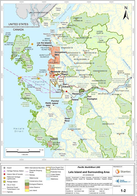
Figure 2: Project layout and surrounding area (Stantec)
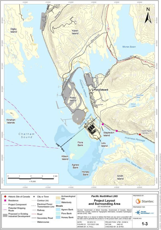
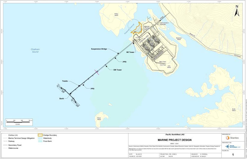
Figure 3: Detailed Project layout (Stantec)
2.2 Project Design Change
Following the public comment period on the EIS, the proponent revised its Project design to address comments raised by governments, Aboriginal groups, and the public in relation to marine issues, and to avoid and reduce environmental effects of the Project. The key changes, confirmed in a Pacific NorthWest LNG Project Design Mitigation report (October 6, 2014) were:
- Redesigning the marine terminal and relocating the berths to remove Project infrastructure on Flora Bank; eliminating the need for dredging on Agnew Bank and the associated disposal at sea of dredged sediment.
- Moving the construction worker accommodation facility (accommodation camp) from Lelu Island to a third party owned-and-operated accommodation camp on private property in Port Edward and/or in the Prince Rupert area.
Because the accommodation camp would no longer be developed, owned, or operated by the proponent, or for the exclusive use of the proponent, the Agency did not consider the construction and operation of the accommodation camp to be part of the Project for the purposes of the federal EA. The transportation of workers to and from the Project site is similarly outside the scope of the assessment. However, environmental effects from the accommodation camp that interact with the Project effects were included in the cumulative effects assessment for the relevant valued components. The Agency notes that the British Columbia Environmental Assessment Office assessed the potential adverse social, economic, and health effects of the work force required during the construction phase of the Project.
On December 12, 2014, the proponent submitted an Addendum to the EIS that provided additional information requested by the Agency regarding the environmental effects of the new Project design. The information and analysis summarized in the Draft EA Report assesses the environmental effects of the Project with the design change.
2.3 Project Components
The Project consists of the following components:
LNG Trains: Natural gas transported to the facility would be processed in LNG trains. Each train would consist of a feed gas receiving unit, pressure let down unit, gas treatment unit, gas dehydration unit, mercury removal unit, fractionation unit, and liquefaction unit. The facility would contain up to three identical 6.4 million tonnes per annum liquefaction trains. Processing would be powered by gas turbines.
LNG Storage: Up to three 180 000 m³ full-containment, double wall LNG storage tanks would be constructed for the facility. The tanks would include: instrumentation and systems for measuring and recording level, pressure and temperature; leak/gas detection systems; cool-down control systems; valves for pressure and vacuum protection; and a control system for fire detection and protection.
LNG Loading (Marine Terminal): The terminal would consist of a 2.7 km jetty that includes a 1.6 km clear-span suspension bridge and a 1.1 km conventional pipe pile trestle extending west from Lelu Island to the marine terminal berths beyond Agnew Bank. The trestle and topside infrastructure would include a field control room, insulated cryogenic piping, pumping equipment, and LNG loading infrastructure. The marine terminal berths would be capable of berthing 217 000 m³ LNG carriers up to 315 m in length. LNG from the storage tanks would be pumped to the marine terminal berths and then loaded into the ships by marine loading arms.
Utilities and Offsite Facilities: To support the operation of the LNG facility, the following components would be required: flare system for managing release of gas in testing and emergency situations; electrical power supply for process pumps, cooling fans, lighting, etc.; bulk storage; water supply infrastructure; waste water treatment systems (upgrade and use of existing system on mainland); storm water management infrastructure; fire control infrastructure; and compressed air and nitrogen generation systems.
Non-Manufacturing Facilities: Other Project components not related to manufacturing LNG include a Materials Offloading Facility, bridge and short access road to Lelu Island, administration and maintenance buildings, site fencing, site lighting, and habitat compensation measures.
Temporary Construction Components: A pioneer dock would be built for initial off-loading of construction equipment (prior to construction of the Materials Offloading Facility).
The Project does not include pipeline transportation of natural gas from gas fields in northwestern B.C., which would be provided by the Prince Rupert Gas Transmission Project, proposed by TransCanada Pipelines Ltd.
2.4 Physical Activities
The Project is expected to consist of the activities summarized in table 2:
|
Construction: Approximately 5 years from a decision under CEAA 2012 |
|
|---|---|
|
Site Preparation |
Tree removal and vegetation clearing, grading, and general site preparation within the terrestrial Project area, including site preparation for the LNG facility on Lelu Island, and site preparation for the bridge footings and road access on the mainland. |
|
Onshore Construction |
Construction of a two-lane bridge connecting Lelu Island to the mainland, including bridge footings on the mainland. Upgrade of Skeena Drive and construction of a short, private access road at the eastern abutment of the bridge. Construction of the LNG production facility (up to the point of connection with the natural gas transmission line). Construction of the LNG storage tanks (three 180 000 m³ tanks). Construction of utilities and offsite facilities. Construction of non-manufacturing facilities. |
|
Construction: Approximately 5 years from a decision under CEAA 2012 |
|
|
Dredging |
Dredging within the Materials Offloading Facility of approximately 200 000 m³ of sediment and approximately 590 000 m³ of rock. Rock would be used for Project construction. |
|
Disposal of Dredged Sediment |
Loading, transportation, and disposal of dredged sediment in Brown Passage and on Lelu Island. Approximately 192 000 m³ would be disposed at Brown Passage and the top 1 m of dredged sediment (approximately 8,000 m³) would be disposed of on Lelu Island. |
|
Marine Construction |
Construction, use, and decommissioning of a temporary pioneer dock for initial offloading of construction equipment until Materials Offloading Facility is built. Construction of a two-lane bridge connecting Lelu Island to the mainland, including bridge footings in Lelu Slough. Construction and use of the Materials Offloading Facility (pile driving, berthing of large roll-on, roll-off barges, and ships). Construction of the marine terminal (suspension bridge and trestle from Lelu Island to beyond Agnew Bank, LNG loading infrastructure, and marine terminal berths). |
|
Vehicle Traffic |
Use of the two-lane bridge and short access road connecting Lelu Island to the mainland by construction workers and vehicles. |
|
Waste Management and Disposal |
Disposal of cleared vegetation, peat, waste rock, and overburden. Culturally Modified Trees that require removal would be offered to local Aboriginal groups. Merchantable timber on Lelu Island would be harvested by local enterprises and removed from the site. Overburden from the terminal site would be temporarily stockpiled onsite and transported to an approved disposal area. Sand and gravel would be salvaged and incorporated into the cut-fill balance where available. Peat and 8,000 m³ of dredged sediment would be piled and stored in a containment area on Lelu Island for draining. Effluent would be captured, monitored, and treated if necessary before discharge into the marine environment. Removal of sewage and grey water from the toilets by septic truck and barge. Discharge of waste waters appropriately into waste water treatment facilities on the mainland. Management of solid, liquid, and hazardous waste. Collection and treatment of storm water runoff from plant areas subject to oil contamination. Remaining clean runoff water would be directed towards the drainage system collected by surface ditches for discharge to the ocean via pre-disturbance drainage pathways. |
|
Operational Testing and Commissioning |
Treatment and disposal of liquid effluent from commissioning, including sea water used for facility hydrostatic testing, at the marine terminal outfall. |
|
Site Clean Up and Reclamation |
Post-construction site clean-up. Re-vegetation (if appropriate). |
|
Operation: Over 30 years from construction completion |
|
|
LNG Facility and Supporting Infrastructure on Lelu Island |
Operation of facility 24 hours per day, 365 days per year. LNG production and storage. Operation of gas-fired turbines capable of producing up to 1100 megawatts of combined mechanical and electrical power (including spare units). Facility maintenance and testing. |
|
Marine Terminal Use |
Berthing and hoteling of 315 m Q-Flex LNG carriers. Loading of LNG on to LNG carriers. |
|
Shipping |
Phase 1 of the Project: one LNG carrier would be calling at the terminal approximately every two days. Phase 2 (at full build out): approximately one LNG carrier per day and 350 calls per year at the terminal. Ship and tug activities (including moorage and transit) between the terminal and the Triple Island pilotage station using one of three potential shipping routes (primary, northern and southern). |
|
Waste Management and Disposal |
Management of solid, liquid and hazardous waste. Vegetation management. Shipping waste management. Water management (storm water, effluent, sewage, and grey water). Utility pipelines from Port Edward would provide water and sewer services for the LNG facility and would be attached to the permanent road bridge from Lelu Island to the mainland. |
|
Fish Habitat Offsetting |
Construction of fish habitat as part of the fish habitat offsetting plan. |
|
Wetland Habitat Compensation |
Construction or enhancement of wetland habitat as a component of the wetland compensation strategy. |
|
Decommissioning: After cessation of operations |
|
|
Dismantling Facility and Supporting Infrastructure |
Dismantle and recycle facility equipment and supporting infrastructure. |
|
Dismantling of Marine Terminal |
Dismantle terminal and associated infrastructure (piping, etc.). Certain intertidal and subtidal structures at the marine terminal and Materials Offloading Facility may remain in place, pending the decommissioning plan and future requirements of the Prince Rupert Port Authority. |
|
Waste Disposal |
Recycling and disposal of facility components. |
|
Site Clean Up and Reclamation |
Preparation of the disturbed portion of Lelu Island for other industrial purposes or reclamation to restore ecological values in consultation with the Port Authority. |
Project decommissioning was assessed at a level commensurate with the level of detail currently available regarding likely decommissioning activities. Project decommissioning would be subject to the requirements of a lease with the Prince Rupert Port Authority and other regulatory requirements at that time. The Prince Rupert Port Authority may opt to keep marine infrastructure (e.g. access bridge to mainland, Materials Offloading Facility, and marine terminal) in place after decommissioning for future commercial activity. Prior to decommissioning, the proponent would be required to develop, in consultation with Aboriginal groups and other relevant parties, a decommissioning plan to submit to the Agency. The proponent would also be required to report on decommissioning activities during that phase.
3 Purpose of Project and Alternative Means
3.1 Purpose of the Project
The purpose of the Project is to convert natural gas originating from Progress Energy Canada Ltd.'s reserves in the Montney Basin (straddling northern B.C. and Alberta) into LNG for export to Pacific Rim markets in Asia. Once delivered to markets, the LNG would be returned to its gaseous state and sent through pipelines for residential, commercial and industrial uses. The Project is intended to meet current demand for LNG supply contracts from Pacific Rim markets, particularly Japan, and to align with the Government of B.C.'s support for development of the LNG export industry.
3.2 Alternative Means of Carrying Out the Project
In the EIS, the proponent identified alternative means of carrying out the Project that are economically and technically feasible. The proponent described general environmental effects associated with each alternative and the rationale for selection of the preferred alternative. Alternatives were considered for the following components:
LNG Production Processes
Two LNG production processes were considered feasible: the propane pre-cooled mixed refrigerant process; and, the ConocoPhillips Optimized Cascade® process. The proponent's decision regarding these two alternatives would depend on a detailed economic and technical analysis of the full-facility designs presented by competing consortia during front end engineering design. Differences between the processes are related to the energy consumed by the systems to produce LNG and resultant differences in air and greenhouse gas emissions. The difference in efficiencies and emissions is minor and effects would be very similar for either option.
Main Refrigerant Compressor Drivers
Three main refrigerant compressor drivers were considered: heavy duty industrial gas turbines, aero-derivative gas turbines, and electric motors. The need for a gas-powered source for electric drivers results in the environmental effects of electric motors being similar to the gas-turbine drivers. Based on specific machine types and design parameters, the aero-derivative configuration was found to be more efficient and to provide marginally better economics, in part because of the slightly lower effects on air quality and greenhouse gas management. The aero-derivative gas turbine was chosen as the preferred alternative by the proponent.
Source of Electrical Power
Two alternatives were evaluated for electrical power: onsite generation, and offsite generation. Using electrical power from BC Hydro was not considered feasible due to the lack of available electricity to supply the plant in the Project's timeline. Onsite power generation from aero-derivative gas turbines was selected as the preferred option by the proponent because it eliminates the risks of power reliability that a transmission line would introduce. The proponent also noted that the onsite power generation option has fewer effects on wildlife, birds, and vegetation since it does not require construction of a transmission line. The proponent has committed to using third party external power for non-essential needs when renewable energy sources are more mature and electricity is made available, to lower greenhouse gas emissions as much as possible.
Land-based Access to Lelu Island
Three corridors were considered to access Lelu Island. The southern corridor crosses from Lelu Island to Stapledon Island and, subsequently, to the mainland. Northern corridor A crosses directly from Lelu Island, and northern corridor B requires an additional bridge at the neck of the peninsula on the northeastern side of the island. All three options were considered technically and economically feasible by the proponent. Northern corridor A was selected as the preferred alternative by the proponent. This option has a single bridge and the shortest length crossing Lelu Slough, which would reduce the potential for environmental effects on fish habitat and riparian areas from shading and pile installation. Although this preferred option is pending final design and negotiations with landowners, this corridor was considered as the Project design for the purposes of the EA.
Site Location
The proponent began site selection in 2011 and originally reviewed 20 locations. Five locations were initially considered feasible: Port Edward (Lelu Island), Georgetown Mills, Port Simpson, Gobeil Bay (Douglas Channel), and Kitimat (Douglas Channel). These five locations were assessed based on geohazards (surface faulting, soil liquefaction risk, tsunami, slope stability, flooding, shoreline stability, and erosion), marine aspects (navigation distance, marine terminal length, Materials Offloading Facility trestle length, navigation concerns, and dredging volume), and infrastructure and economic aspects (pipeline length, land preparation, regional economic infrastructure, proximity to major airports, highway and rail, and proximity to communities). Georgetown Mills, Port Simpson and Gobeil Bay were eliminated from further consideration as they were considered neither technically nor economically feasible. Major issues with these sites included the substantially higher estimated costs for site development, large volumes of earthworks, long and complex LNG carrier routes, and potential for faulting and liquefaction. Port Edward (Lelu Island) and Kitimat were then compared based on the following environmental considerations: removal of riparian vegetation, removal of terrestrial and marine habitat, and potential environmental effects of an accident or malfunction. The environmental effects are similar for both sites; however, other industrial developments in Kitimat would reduce access to available industrial land and introduce considerably more tanker traffic within a complex geographic corridor. The proponent stated that the Lelu Island location would have more marine traffic oversight from the Prince Rupert Port Authority, and concluded that risks of accidents or malfunctions that could lead to environmental effects would be reduced at this location. Lelu Island was selected as the preferred site by the proponent.
Placement of Marine Marine Terminal and Materials Offloading Facility
Three alternatives for placement of the marine terminal and Materials Offloading Facility were considered feasible by the proponent, all of which include a trestle located on the north end of Lelu Island, extending southwest along Porpoise channel. The three options varied only in the length of the trestle and the associated dredging volumes. The alternatives were assessed based on potential environmental effects from dredging and construction, effects on the marine environment and navigation, and cost of construction. The option that was chosen by the proponent was a suspension bridge and trestle leading to marine terminal berths located 2720 m offshore, west of Agnew Bank at a natural channel outside of Porpoise Channel, with the Materials Offloading Facility placed in a small cove, oriented parallel to Porpoise Channel. This option has the smallest dredging volumes (approximately 200 000 m³) and fewer associated environmental effects on the marine environment, as well as fewer effects on navigation. Although this option had the highest construction costs as a result of building a suspension bridge, it is the preferred option due to reduced potential environmental effects.
Alternative to Disposal at Sea for Marine Sediments
Disposal at sea, terrestrial disposal, and beneficial re-use were considered for the dredged sediment. Disposal at sea was considered the preferred alternative by the proponent for disposal of marine sediment from dredging; however, due to restrictions regarding disposal at sea, the proponent also assessed terrestrial disposal and determined the top 1 m of dredged marine sediment would be disposed of on Lelu Island.
Locations for the Disposal at Sea of Marine Sediments
The proponent considered nine sites within 35 km of Lelu Island and with a minimum depth of 150 m for disposal at sea of marine sediments. Two options were not considered feasible because they had insufficient capacity, and three more were not considered feasible due to navigation issues, use by other proposed projects, or potential sediment plume effects on rockfish conservation areas. The four remaining options considered by the proponent were southwest Kinahan Islands, the southwest corner of the Prince Rupert Port Authority boundaries, Stephens Island, and Brown Passage. Effects on fish and fish habitat and navigation informed the assessment of remaining disposal site options.
The proponent noted that the southwest corner of the Port Authority boundary is an important area for marine birds and adjacent to a rockfish conservation area, and was therefore removed from consideration. Brown Passage has the highest capacity for disposal, is the most well studied area, has the fewest nearby commercial fishing areas, and has been previously used for disposal; however, it is also farthest from Lelu Island. Stephens Island has not been as well studied, has less capacity, and is almost as distant as Brown Passage so has little advantage over Brown Passage. Southwest Kinahan Islands has sufficient capacity and is the closest of the feasible alternatives, but community knowledge indicates that this area is of particular importance for commercial prawn and shrimp harvesting. Brown Passage was selected as the preferred disposal at sea site by the proponent.
Project Site Layout
A number of layout designs were considered by the proponent at various levels of detail. Key features in site planning included locations of the LNG tanks, main flare stack, low pressure flare stack, warehouse/workshop/laboratory facilities, and administrative buildings. The proponent considered site safety, efficiency, and local stakeholder concerns such as visual, noise, and light effects in its assessment of Project site layout. The proponent's preferred alternatives for the various components are: LNG tanks on the north side of Lelu Island, main flare stack toward the southern tip of Lelu Island, low pressure flare stack on the western corner of Lelu Island, warehouse/workshop/laboratory facilities in the middle of the northeastern side of Lelu Island, and administrative facilities on the peninsula on the northern side of Lelu Island.
3.2.1 Comments Received
Government authorities
Environment and Climate Change Canada questioned the proponent's analysis of the feasibility of alternative disposal at sea sites. Environment and Climate Change Canada requested information about the site depths and capacities, and the "Zone of Siting" feasibility which identifies the maximum feasible distance for travel to the disposal site from the dredging location. The proponent responded with additional information on the capacities of the identified alternatives and the Zone of Siting feasibility. Furthermore, Environment and Climate Change Canada advised that some of the dredged sediment may not be suitable for a disposal at sea permit. It advised that further detail should be provided as to the alternative means by which this material would be managed and associated effects.
Aboriginal groups
Lax Kw'alaams Band raised concerns over the suitability of Lelu Island as the preferred site location because of the effects on the environment. Lax Kw'alaams Band described Lelu Island as ecologically important due to its proximity to important fisheries habitat within the Skeena River Estuary. It also identified Lelu Island as an area of active, historic, and desired future use for Lax Kw'alaams Band that holds important cultural values as a part of the cultural landscape of the Coast Tsimshian. Lax Kw'alaams Band listed several technical and environmental drawbacks of the preferred site location and questioned the proponent's analysis of alternative site locations. Lax Kw'alaams Band, Gitxaala Nation, and Metlakatla First Nation were also concerned with the location of the marine terminal presented in the EIS (February 2014) and its potential impacts on the environment and Aboriginal rights.
The proponent provided additional information on why Lelu Island is the preferred site location, including information on the economic feasibility and the potential environmental effects of accidents and malfunctions of other sites they considered. In response to concerns raised about effects resulting from construction and operation of marine terminal on Agnew Bank, the proponent conducted further analysis on the feasibility of constructing the marine terminal berths in deep water beyond Agnew Bank. The proponent concluded this option was feasible and adjusted its Project design. Section 2.2 discusses the changes to the Project design.
Metlakatla First Nation and Kitsumkalum First Nation raised concerns about disposal at sea and specifically with Brown Passage being the preferred site for disposal at sea. The concerns related to ecological and human health impacts that could result from the disposal of sediment and associated impacts to Aboriginal rights. The proponent reiterated its preference for Brown Passage as a disposal at sea location. Through changes to the Project design and by conducting further investigation of the areas to be dredged, the proponent proposed a reduced volume of sediment that would require disposal (from over 7 000 000 m³ to 192,000 m³) as well as reduced duration of disposal activities (from one year and six months to approximately seven months). The proponent committed to a follow-up program for marine country foods [1] at the Materials Offloading Facility to verify the predictions of effects on human health within the EA. Additionally the proponent proposed a follow-up program to verify the predictions of sediment dispersion from dredging and disposal activities (see section 9 for the Agency's recommended follow-up program).
For future projects in the area, the Prince Rupert Port Authority has established a Sediment Management Working Group with representatives from Metlakatla and other Aboriginal groups. The working group will develop a Port of Prince Rupert Dredged Sediment Management Guide that includes alternate uses for sediment from dredging activities, identification of potential locations for disposal, and other sediment management guidance.
Lax Kw'alaams Band was concerned that the proponent did not include a description of the economic and feasibility criteria and information on how these criteria were selected. Lax Kw'alaams Band was also concerned that the proponent did not provide proportionate economic costs of alternatives. In response, the proponent provided the definition of environmental and economic feasibility used for the evaluation of economic and technical feasibility and suggested that proportional costs were not required for the assessment of alternatives.
Lax Kw'alaams Band was also concerned that an alternatives assessment was not conducted for the routing of the pipeline that would provide natural gas to the facility. The proponent indicated that the pipeline is not a component of the Project and therefore did not require an alternatives assessment, and that effects of the pipeline were considered in the cumulative effects assessment.
Metlakatla First Nation, Gitxaala Nation and Lax Kw'alaams Band raised concerns that the proponent did not incorporate traditional knowledge and Aboriginal use of lands and resources into the assessment of alternatives. The proponent clarified where it considered Aboriginal use in the assessment of alternatives.
Public
The public expressed concerns about the selection of Lelu Island as the preferred site location and effects of the marine terminal on Agnew Bank due to its proximity to important salmon rearing habitat on Flora Bank. Concerns were also raised about the selection of Brown Passage as the preferred disposal at sea location because of the potential effects on halibut habitat. Tuck Inlet was suggested as a preferable site.
3.2.2 Agency Analysis and Conclusion
The Agency reviewed the alternatives assessment conducted by the proponent, and the proponent's responses to concerns raised. For each component required in the EIS Guidelines, the proponent identified the technically and economically feasible alternatives, identified the environmental effects of the feasible alternatives, and selected the preferred alternative to be fully assessed.
The Agency is satisfied with the responses the proponent provided to concerns raised and the additional detail the proponent provided for choosing Lelu Island as the preferred site location.
Overall, the Agency is satisfied that the proponent has sufficiently assessed alternative means of carrying out the Project for the purposes of assessing the environmental effects of the Project under CEAA 2012.
4 Consultation Activities and Advice Received
4.1 Aboriginal Consultation
4.1.1 Aboriginal Consultation led by the Agency
The federal government has a duty to consult Aboriginal groups and, where appropriate, accommodate when its proposed conduct might adversely affect potential or established Aboriginal or treaty rights. Aboriginal consultation is also undertaken more broadly as an important part of good governance, sound policy development, and decision making. In addition to the federal government's broader obligations, CEAA 2012 requires the EA to consider the effects on Aboriginal peoples of any Project-related effects on health and socio-economic conditions, physical and cultural heritage, current use of lands and resources for traditional purposes, and changes to any structure, site, or thing that is of historical, archaeological, paleontological, or architectural significance. In order to fulfill the Crown's consultation obligations, the Agency conducted Aboriginal consultation in an integrated manner with the EA process.
For the purposes of the EA, the Agency served as the federal Crown Consultation Coordinator while the British Columbia Environmental Assessment Office was the lead for provincial Crown consultation activities. The Agency and B.C. Environmental Assessment Office coordinated consultation activities to the extent possible, including sharing correspondence and joint meetings with Aboriginal groups.
The Agency initially identified five Aboriginal groups whose potential or established Aboriginal rights or title could be adversely impacted by the Project:
- Lax Kw'alaams Band;
- Metlakatla First Nation;
- Gitxaala Nation;
- Kitsumkalum First Nation; and
- Kitselas First Nation.
In 2013, the Agency added Gitga'at First Nation to the list of Aboriginal groups whose potential or established Aboriginal rights or title could be adversely impacted by the Project. Treaties have not been established with any of the Aboriginal groups considered in the EA. However, the Agency is aware that both Kitselas First Nation and Kitsumkalum First Nation are currently involved in the British Columbia Treaty Commission Process, and on August 4, 2015 signed Agreements-in-Principle with the province of B.C. and Canada.
The Agency supports Aboriginal participation through its Participant Funding Program. Funds were provided to reimburse eligible expenses of Aboriginal groups that participated in the EA. All six identified Aboriginal groups applied for and received funding through this program. In addition, Aboriginal groups located upstream of the Project, including Gitxsan First Nation, Gitanyow First Nation, Takla Lake First Nation, and the Office of the Wet'swet'en were invited to apply for funding in order to provide comments on the Draft EA Report, in response to their concerns regarding potential effects to salmon that migrate throughout the Skeena watershed. In total, the Agency awarded $367,854 to support Aboriginal participation in the EA.
The Agency consulted all six Aboriginal groups through a variety of methods including phone calls, emails, letters, and in-person meetings. The Agency provided regular updates to the Aboriginal groups to keep them informed of key developments and to solicit feedback. The Agency requested written comments from Aboriginal groups on the Project Description, the Draft EIS Guidelines, and the EIS and associated documents (see table 3). The Agency is also requesting comments on the Draft EA Report and the potential conditions that could apply to the Project if it is ultimately allowed to proceed.
|
Document or Subject of Consultation |
Dates |
|---|---|
|
Summary of the Project Description |
February 19, 2013 to March 11, 2013 |
|
Draft EIS Guidelines |
April 8, 2013 to May 8, 2013 |
|
Extended draft EIS Guidelines |
August 21, 2013 to September 20, 2013 |
|
EIS and associated documents |
April 2014 to December 2015 |
|
Draft EA Report and potential conditions |
February 10, 2016 to March 11, 2016 |
The Agency held meetings during the review of the EIS with Aboriginal groups, the proponent, and representatives from the province. These meetings provided an opportunity for representatives of Aboriginal groups to hear presentations on the EA and the proponent's EIS and to provide oral and written comments. These comments informed the Agency's review of the EIS and identified the need for subsequent information requests to the proponent to more fully assess the effects of the Project.
Aboriginal groups submitted many detailed comments about the Project and the EA in areas ranging from air quality, to the marine environment, to socio-economic effects. The majority of concerns related to impacts to marine fish and fish habitat, country foods, Aboriginal use of lands and resources, and Aboriginal rights.
Potential environmental effects with respect to Aboriginal peoples are discussed in sections 6.9 to 6.12 and impacts on potential or established Aboriginal rights or title are discussed in section 8. Appendix 11.6 contains a summary of concerns raised by the Aboriginal groups during the EA process, and includes both a proponent and Agency response. All of these comments have been considered in preparing this report.
4.1.2 Aboriginal Consultation and Engagement Activities by the Proponent
The EIS indicates that the proponent engaged all Aboriginal groups identified by the Agency and B.C. Environmental Assessment Office through meetings and letter and email correspondence. Meetings included presentations and discussions on technical information related to the Project, the Project's feasibility assessments and pre-front end engineering design, the Project's potential impacts on Aboriginal groups' interests, Aboriginal rights or title, and opportunities to participate in the Project. The proponent also hosted open houses in Port Edward and Prince Rupert on five separate occasions, to which all Aboriginal groups were invited.
Lax Kw'alaams Band and Metlakatla First Nation, the two groups identified as the most impacted by the Project, were provided with the opportunity to participate in archaeological inventory surveys and investigative geotechnical programs on Lelu Island, and to tour the Project area. Lax Kw'alaams Band, Metlakatla First Nation, Kitsumkalum First Nation, Kitselas First Nation and Gitxaala Nation also participated in studies in the area around Lelu Island. These studies included archeological and Culturally Modified Tree surveys, marine foreshore surveys, marine bird and bird nesting surveys, eelgrass surveys, marine country foods sampling, marine sediment sampling, surveys of Brown Passage by a remotely operated underwater vehicle, soil sampling, freshwater streams fish sampling, meteorological data collection, and environmental monitoring of drilling programs. The Aboriginal groups were invited to review the findings of these studies.
The proponent established capacity agreements with all of the listed Aboriginal groups, with the exception of Lax Kw'alaams Band, which declined the proponent's Environmental Assessment Agreement funding offer. These capacity agreements support the participation of Aboriginal groups in the EA, including the completion of traditional knowledge and traditional use studies, community-specific socio-economic impact assessments and other Project-related work. The proponent received traditional use studies from Metlakatla First Nation, Gitxaala Nation, Kitselas First Nation, and Kitsumkalum First Nation, and an interim traditional use study report from Gitga'at First Nation. The Agency is aware that the proponent has made ongoing efforts to negotiate Impact Benefit Agreements with potentially affected Aboriginal groups to address any potential residual impacts not addressed through the EA or permitting processes. The Agency is not involved in these confidential discussions but acknowledges that these agreements can be considered important in the context of accommodation for impacts on potential or established Aboriginal rights or title.
The proponent informed the Agency of a Project design change on October 6, 2014. The proponent informed Aboriginal groups earlier about the design change and met with Aboriginal groups following submission of the Project design change report.
The proponent has committed to ongoing engagement with Aboriginal groups if the Project proceeds and to continue to consult with them about the Project's potential impacts to their interests, by:
- providing information collected about the Project;
- offering capacity funding to review and assess that information;
- discussing with Aboriginal groups any responses to information they provide and any queries that they have about the Project;
- reviewing and responding to all information about Aboriginal groups' interests associated with the Project; and
- consulting with Aboriginal groups as may be required by the Crown during the permitting process.
4.2 Public Participation
4.2.1 Public Participation led by the Agency
The Agency provided four opportunities for the public to participate in the EA process by commenting on:
- the Project Description;
- the Draft EIS Guidelines;
- the summary of the proponent's EIS; and
- this Draft EA Report and potential conditions.
Notices of these opportunities to participate were posted on the Canadian Environmental Assessment Registry Internet Site, as well as through local media.
Groups that provided comments include the: South Peace Oilmen's Association, Prince Rupert Rod and Gun Club, University of Alberta, T. Buck Suzuki Foundation, Skeena Wild Conservation Trust, United Fishermen and Allied Workers Union, Prince Rupert Environmental Society, Skeena Fisheries Commission, Skeena Watershed Conservation Coalition, and World Wildlife Fund Canada. Comments were also received from residents across B.C.
Paper copies of the Draft EIS Guidelines and the EIS Summary were made available at public viewing centres in Prince Rupert and Port Edward. During the review of the EIS, the Agency conducted two open houses, one in Prince Rupert and one in Port Edward. The open houses were held jointly with the provincial government and with participation from the proponent. These sessions, attended by about 200 people, provided opportunities for members of the public to speak with government representatives about the EA process, and to review the proponent's presentation of its EIS.
The Agency supported public participation through its Participant Funding Program. A total of $94,200 was provided to the following groups: T. Buck Suzuki Environmental Foundation, Skeena Fisheries Commission, United Fisherman and Allied Workers' Union, World Wildlife Fund Canada, Skeena Watershed Conservation Coalition, Prince Rupert Environmental Society, Skeena Fisheries Commission, and Heiltsuk Tribal Council.
The public expressed concern about the Project's effects on fish and fish habitat from dredging, disposal at sea, and marine shipping. Concerns were also raised about greenhouse gas emissions, and changes to air quality. Many comments focused on the cumulative effects of multiple LNG facilities in northwestern B.C. Other issues raised included effects on marine mammals, human health, water quality, wildlife, and the risk of Project-related accidents and malfunctions. Members of the public also expressed support for the Project.
4.2.2 Public Participation Activities by the Proponent
The proponent conducted six open houses in Prince Rupert and Port Edward prior to EIS submission. About 300 members of the public participated in these events. The proponent also conducted over 50 meetings with local businesses, environmental, and community groups. A series of four roundtable discussions for local marine users were held to address navigation and marine use issues. Following submission of the EIS, the proponent participated in two open houses, in April 2014, during the public comment period. In October 2014, the proponent conducted two additional information sessions in Prince Rupert and Port Edward to provide information on the Project design change. The proponent collected the views of the public regarding the design change. These views included concerns about the potential effects of the proposed bridge, including effects on navigation, ambient light, visual quality, and marine resources. Many members of the public were also supportive of the design change.
Information was provided to the public via the proponent's website, e-newsletters, print materials, presentations, and social media. Questions and comments from the public were also solicited through a toll-free phone line, public email address, and comment cards (distributed at open houses and to Port Edward residents by mail). Storefront offices were established in Prince Rupert and Port Edward.
4.3 Participation of Federal and Other Experts
Federal departments provided specialist or expert information or knowledge relevant to the Project in accordance with section 20 of CEAA 2012. They provided advice to help determine whether a federal EA was required, participated in the review of the Draft EIS Guidelines, the EIS, the Addendum and information request responses, and provided input into the preparation of the Draft EA Report.
Fisheries and Oceans Canada has regulatory and statutory responsibilities under the Fisheries Act, and provided advice and information related to fish and fish habitat and marine mammals, aquatic species at risk, commercial, recreational and Aboriginal fisheries, physical oceanography, accidents and malfunctions, and mitigation measures including habitat offsetting.
Environment and Climate Change Canada has regulatory and statutory responsibilities under the Canadian Environmental Protection Act, 1999, Migratory Birds Convention Act, 1994, Species at Risk Act, and the pollution prevention provisions of the Fisheries Act. Environment and Climate Change Canada provided advice related to air quality and greenhouse gases, terrestrial species at risk, migratory birds, acidification and eutrophication, dredging and disposal at sea of marine sediment, and accidents and malfunctions.
Transport Canada has regulatory and statutory responsibilities under the Navigation Protection Act, and provided advice related to changes to the environment that may impede navigation, effects on Aboriginal people, and accidents and malfunctions.
Lelu Island and its surrounding waters are federal port lands administered by the Prince Rupert Port Authority. The Port Authority has regulatory authorities for the Project pursuant to the provisions of the Canada Marine Act, the Port Authorities Operations Regulations and the Port Authority's Letters Patent issued by the Minister of Transport. The Port Authority is responsible for providing a land lease and implementing the Federal Policy on Wetland Conservation. The Port Authority provided comments on navigation, movement of vessels, use of Port land including waste management, wetland function compensation, and effects on fish and marine mammals.
Natural Resources Canada provided advice related to natural events such as tsunamis and earthquakes, and effects on the geophysical environment such as environmental marine geology, sedimentology, and sediment transport.
Health Canada provided advice on potential effects on human health related to country foods, noise, light, and air quality.
Parks Canada provided advice on archeological and heritage sites.
The Agency and B.C. Environmental Assessment Office coordinated the federal and provincial EAs to the fullest extent possible, including working closely on the technical review of the EIS. The following provincial ministries provided expertise to the cooperative EA as part of the technical working group: Ministry of Environment; Ministry of Health; Northern Health; Ministry of Forests, Lands and Natural Resource Operations; Climate Action Secretariat; Ministry of Transportation and Infrastructure; and Ministry of Jobs, Tourism and Skills Training. The expertise provided by provincial ministries was considered in the Agency's assessment of the Project's environmental effects and mitigation measures.
The B.C. Oil and Gas Commission regulates LNG facilities in B.C. under the Oil and Gas Activities Act and Liquefied Natural Gas Facility Regulation and participated as a member of the technical working group. Amendments made in 2014 to the Canada Marine Act enable the federal government to adopt provincial regulations to apply to LNG developments on federal port land. On June 20, 2015, the proposed Port of Prince Rupert Liquefied Natural Gas Facilities Regulations were published in the Canadian Gazette. These regulations would establish a federal regulatory regime for LNG projects at the Port of Prince Rupert that applies the existing B.C. provincial regulatory regime with some minor exceptions.
These new regulations would apply in addition to all current laws and regulations regarding environmental protection and safety on federal port lands. The regulations would designate the B.C. Oil and Gas Commission as the agency responsible for regulating the construction, operation, and maintenance of facilities used for natural gas supply and LNG production and storage at the Port of Prince Rupert, on behalf of the Government of Canada. Accordingly, the proponent would be required to obtain a number of provincial permits and authorizations as directed by the B.C. Oil and Gas Commission pertaining to the construction and operation of the LNG facility in the Port of Prince Rupert. The Port Authority and other federal agencies would maintain their regulatory oversight, including matters concerning the operation of the Port, the administration of Port lands, navigation and shipping, and protection of the marine and terrestrial environments under their jurisdiction.
5 Geographical Setting
5.1 Biophysical Environment
The Project would be primarily located on and around Lelu Island, in the Hecate Lowland along the western margin of the Kitimat Ranges of the Coast Mountains of B.C. Lelu Island is a small island (219 ha) currently undeveloped and accessible only by water. Lelu Island has gentle topography, with a maximum elevation of 40 m. The soil in the area is high in organic matter, relatively low in pH, and limited in nitrogen. The soil is underlain by a variety of metamorphic rocks (predominately granite). The Lelu Island site is located within the Pacific Maritime ecozone and is occupied by large expanses of muskeg where drainage is poorly established. Dominant vegetation includes moderately productive forests (western red cedar and western hemlock) and forested and shrubby blanket bogs (western red cedar, yellow-cedar, western hemlock, and shore pine). Some of the forested areas on the island are old forests which are defined as structurally diverse stands older than 250 years. The Government of B.C. has identified the nearby Rachael islands and Kinahan islands as biodiversity areas; Lucy Islands and Ksgaxl/Stephens Island are identified as conservancies.
The Prince Rupert region provides seasonal and year-round habitat to approximately 359 terrestrial wildlife species, including 62 mammals, 288 birds, five amphibians, and two reptiles. Lelu Island provides habitat for terrestrial species such as grey wolf, black-tailed deer, Pacific marten, bats, American robin, Pacific wren, bald eagle, northwestern salamander, and rough-skinned newt. Lelu Island and the surrounding shallow waters, eelgrass beds and tidally exposed mudflats also support populations of marine birds. Nine terrestrial species listed under the Species at Risk Act and three terrestrial species designated by the Committee on the Status of Endangered Wildlife in Canada potentially occur in the vicinity of Lelu Island.
Key marine features on and around Lelu Island include rocky shorelines, soft sediment in protected bays and channels, and expansive shallow banks and mudflats. Lelu Island is bordered by deep water to the northwest in Porpoise Harbour (up to 25 m) and to the southeast in Inverness Passage (about 15 m deep). The water is shallower west of Lelu Island along Flora and Agnew Banks. Flora Bank, immediately west of Lelu Island, is a large, flat, intertidal area of fine to medium sands with eelgrass beds that cover 10-15% of the 325 ha area seasonally. Agnew Bank, to the northwest of Flora Bank, is a relatively flat subtidal area of much finer sediments with no eelgrass beds. At the southwest end of Flora Bank, the seabed drops off with a gradient of about 10 per cent changing from 5 m deep to 50 m deep in the more open waters of Chatham Sound. The Prince Rupert region experiences large semi-diurnal tides (two low and two high tides per day of different heights), with a relatively large tidal range of 7.4 m.
The marine habitats around Lelu Island are representative of marine ecosystems throughout the north coast of B.C. Two unique biological characteristics of the Skeena River estuary are the size of the eelgrass beds on Flora Bank and the annual migratory passage of important salmon stocks originating from the Skeena River. Eelgrass is widely recognized as important nearshore habitat for juvenile and adult invertebrates and fish. Eelgrass beds can provide cover from predation, reduce local current regimes (allowing for settlement of organisms), and increase secondary productivity by adding to local habitat complexity and surface area. Species found in the Project area, including Flora Bank and Agnew Bank, include Pacific herring, surf smelt, shiner perch, salmon, flounder, halibut, English sole, big skate, and invertebrates such as Dungeness crab, shrimp, cockles, butter clams, mussels, and littleneck clams. The most common marine mammals in Chatham Sound include humpback whale, northern resident and Bigg's killer whale, harbour porpoise, Dall's porpoise, Pacific white-sided dolphin, and harbour seal. Thirteen marine species (fish, invertebrates, and marine mammals) listed under the Species at Risk Act and six species designated by the Committee on the Status of Endangered Wildlife in Canada potentially occur in the vicinity of the Project.
Westerly winds carry moist, warm air streams up and over the Coast Mountains, depositing large amounts of precipitation, mostly as rain, over the Prince Rupert region with a total of 3060 mm annual average precipitation. Prince Rupert experiences an average temperature of 11.8 to 12.7oC (average 1.0oC in December and 13.5oC in August). Winds recorded at the Prince Rupert airport (7 km west of Prince Rupert) are predominantly southeasterly, averaging 3.5 m/s, and winds recorded at the Holland Rock station (5 km northwest of Lelu Island) are similar to winds at the airport but stronger, averaging 5.8 m/s. Winds occur about 1.1 percent of the time on Holland Rock, as opposed to 5.3 percent at the Prince Rupert airport. Kaien Island topography, which includes steep features, reduces the dispersion of air emissions between the Prince Rupert and Port Edward airsheds.
5.2 Human Environment
The Project would be located on federal lands and waters administered by the Prince Rupert Port Authority and within the municipal boundaries of the District of Port Edward. The Project area contains a variety of topography and vegetation, expansive views of water, and limited views of human intervention and modification. The Project would be located on the mainland portion of the Skeena-Queen Charlotte Regional District which includes the City of Prince Rupert, District Municipality of Port Edward, Regional District Electoral Areas A and C, S1/2 Tsimpsean Indian Reserve 2 (Metlakatla First Nation), Lax Kw'alaams Indian Reserve 1 (Lax Kw'alaams Band), and Dolphin Island Indian Reserve 1 (Gitxaala Nation). The population of this area is 14 397, with 87 percent of the population living in Prince Rupert, 4 percent in Port Edward, and 8 percent in reserves. The proponent estimated that 41 percent of the population identify themselves as being Aboriginal.
The Project would be located in an area with overlapping assertions to rights and title from five Aboriginal groups: Lax Kw'alaams Band, Metlakatla First Nation, Gitxaala Nation, Kitsumkalum First Nation, and Kitselas First Nation. Gitga'at First Nation also asserts Aboriginal rights, but no title, to the same area. These Aboriginal groups report that the Prince Rupert area is used by their members for traditional use activities that include hunting, fishing, harvesting marine resources, and plant gathering. Culturally Modified Trees occur throughout Lelu Island. The presence of Culturally Modified Trees on Lelu Island indicates that the island was an area of resource procurement for fuel, timber, and bark. Many of the trees were modified in prehistoric times but some show significant numbers of bark strips modified as recently as 30 years ago. The Project area provides marine and terrestrial habitat for many culturally important and traditionally harvested species. Traditional activities practiced in the Project area, including the terrestrial and intertidal portions of Lelu Island, include: fishing, particularly for salmon; hunting of deer and other land mammals and birds; harvesting of coastal resources such as shellfish, crabs, and seaweed; and gathering of medicinal, material, and edible plant resources.
The main economic activities in the Regional District include fishing, forestry, energy, transportation, and tourism. Since the late 1990s, the area has experienced industrial closures in the resources sector, including the Skeena Cellulose Pulp Mill, and a general decline in shipments of grain and coal out of its port facilities. Unemployment rates in the Regional District in 2011 (14.2 percent) were much higher than provincial averages (6.7 percent). The Port of Prince Rupert currently serves as a major economic driver in the Regional District.
Major commercial fisheries within the area include salmon (seine and gillnet), Dungeness crab (trap), and shrimp (trawl). Around Triple Island, commercial fisheries include rockfish, red sea urchin, geoduck, and horse clam. Other commercial fisheries occurring at lower reported levels include shrimp and prawn (trap), groundfish (trawl), halibut (hook and line), king crab (trap), and salmon (troll). Several Aboriginal communities hold communal commercial licenses. Target fisheries include halibut, salmon, rockfish, herring, red sea urchin, crab, shrimp, and prawn. Commercial fishing is restricted within the limits of the Prince Rupert Port Authority. These restrictions do not apply to recreational or subsistence fishing, particularly with a line and hook, provided that they do not interfere with navigation. Commercial fisheries continue to occur year-round, with some fisheries having specific timing and quotas. Permanent and temporary shellfish closures exist in areas around the Project due to bio-toxins such as red tide, and sanitary issues from the release of untreated domestic sewage on the north coast.
Currently all deep sea vessel traffic approaches the Port of Prince Rupert from the open waters north of Haida Gwaii, through Dixon Entrance north of Stephens Island, following established shipping routes. Dixon Entrance is also commonly used by deep sea vessels visiting the ports of Stewart and Kitimat. The southern approach sometimes used by smaller vessel traffic traveling to Prince Rupert is between Kitson Island, Lelu Island, and Ridley Island on the east side, and between Holland Rock, East Kinahan Island, and Digby Island on the west side (see figure 1). The number of seagoing vessel calls is increasing each year, with over 465 vessels and 1280 harbour movements in 2013. Prince Rupert Harbour is designated as a compulsory pilotage area under the Pilotage Act. Every vessel that is over 350 gross tonnes, and every pleasure craft over 500 gross tonnes, is required to carry a Pilot and cannot navigate within the harbour unless a certified B.C. Coast Pilot is on board. The Pilot Boarding Station is currently located off Triple Island (54° 17' 6" N; 130° 52' 7" W) approximately 42 km west of the Port of Prince Rupert. Every vessel must at all times proceed at a safe speed in accordance with the Collision Regulations pursuant to the Canada Shipping Act, 2001.
Other industrial projects and activities in the vicinity of the Project include marine terminals (cruise terminal, ship and yacht docking terminal, container terminal, grain terminal, coal terminal, ferry terminal, and wood products terminal), an industrial park (sawmill, car manufacturer facility, and car mechanics shop), log sort, fish processing, and forestry.
Land-use planning for Lelu Island is under the jurisdiction of the Prince Rupert Port Authority. Lelu Island has been identified in the Port Authority's 2020 Land Use Management Plan as having long-term potential for industrial development. The District of Port Edward Official Community Plan identifies the Lelu Island shoreline as an environmentally sensitive area, but recognizes that the Port Authority has planning jurisdiction for the island.
The North Pacific Cannery National Historic Site is located approximately 6 km southeast of the Project. The Prince Rupert heritage railway station, Metlakatla Pass National Historic Site, and the petitioned heritage lighthouses at Triple Island and Lucy Island are also near the Project. There are two provincial parks in the area: Dianna Lake and Prudhoe Lake. The closest recreational area to the Project is Kitson Island, which is located west of Lelu Island at the edge of Flora Bank. Recreational activities, such as beach activities, kayaking, swimming, picnicking, and backcountry camping, take place mostly in and around Kitson Island and Kitson Islet. Recreational fisheries for salmon, halibut, rockfish, crab, prawn, and shrimp occur mainly around the north coast of Stephens Island, Triple Island, Rachael Islands, Lucy Islands, the Kinahan Islands, and Kitson Island.
6 Predicted Effects on Valued Components
6.1 Air Quality
The Agency focused its assessment of air quality on emissions of the following air contaminants: sulfur dioxide (SO2), nitrogen oxides (NOx), carbon monoxide (CO), inhalable particulate matter (PM10), respirable particulate matter (PM2.5), hydrogen sulphide (H2S), and volatile organic compounds (VOCs).
6.1.1 Proponent's Assessment of Environmental Effects
Baseline air emissions were modelled by the proponent using data from five existing operations in Prince Rupert: Northland Terminal, Ridley Island Coal Terminal, Prince Rupert Grain Ltd., B.C. and Alaska Ferries, and Fairview Terminal (Phase I). The proponent indicated that available air quality monitoring data were not used to establish baseline conditions because the data were collected at a time when air emissions were higher due to the presence of industries that no longer exist (e.g. pulp mill). Baseline air emissions for all parameters modelled were predicted to be below the B.C. Ambient Air Quality Objectives and the National Ambient Air Quality Objectives.
According to the proponent, during construction, the main sources of air emissions from the Project are the operation of diesel powered vehicles, heavy construction equipment, and marine vessels. Fugitive dust emissions from vehicle travel and site preparation are expected to be negligible due to the high year-round precipitation and moist soil composition (muskeg). The proponent concluded that overall emissions resulting from construction activities would have a short-term and temporary effect, and would result in a minor effect to air quality compared to operations emissions. As such, the proponent did not model air emissions from construction activities.
During operations, most air emissions would be land-based and continuous, and generated by three thermal oxidizers, six mixed-refrigerant compressor turbine drivers, six natural gas turbine generators, and three flares. The operation of LNG carrier vessels and assist tugboats would also generate air emissions.
Concentrations of air contaminants during operations were calculated at regular intervals using a receptor grid (50 km x 50 km) as well as for 48 sensitive receptor locations such as nearby schools, hospitals, residences, and traditional sites of importance to Aboriginal groups. Baseline and predicted air contaminant concentrations during operations were calculated for each receptor grid point and sensitive receptor location to account for site specific differences. Maximum air contaminant concentrations calculated by the proponent at each point within the grid are shown in table 4. This table provides a comparison of the highest modeled concentrations during operations after mitigation measures have been applied, with modelled baseline concentrations and ambient air quality objectives. The predicted highest concentrations for all contaminants calculated at the grid points are below the most stringent corresponding ambient air quality objectives. Consequently all concentrations calculated at the 48 sensitive receptors were also below the prescribed limits. VOCs were not included in the table, since no applicable objectives are available and the proponent indicated that most VOCs would be oxidized in the waste gas stream and therefore not be of concern. H2S emissions were also not included in the table because the proponent assumed all H2S directed to the thermal oxidizer would be converted to SO2 and that minimal emissions would occur from the flare stacks.
|
Contaminant |
Averaging Period |
Baseline Case (µg/m³) |
Baseline Case + Project Highest Concentrations (µg/m³) |
Ambient Air Quality Objectives (µg/m³)* |
|---|---|---|---|---|
|
*Most stringent limits (a B.C. AAQO, b NAAQO, c New B.C.AAQO) |
||||
|
SO2 |
1 -hour |
34 |
34 |
200 c |
|
3 -hour |
25 |
26 |
375 a |
|
|
24 -hour |
7.6 |
7.7 |
160 a |
|
|
Annual |
0.8 |
0.9 |
25 a |
|
|
NO2 |
1 -hour |
68 |
80 |
188 c |
|
24 -hour |
93 |
101 |
200 b |
|
|
Annual |
3.4 |
4.1 |
60 b |
|
|
CO |
1 -hour |
303 |
303 |
14 300 a |
|
8 -hour |
141 |
142 |
5 500 a |
|
|
PM10 |
24 -hour |
32 |
32 |
50 a |
|
Annual |
3.4 |
3.4 |
- |
|
|
PM2.5 |
24 -hour |
9.9 |
10 |
25 a |
|
Annual |
1.8 |
1.9 |
8 a |
|
Taking the mitigation measures into account, the proponent characterized the residual effects on air quality as low in magnitude, continuous in duration, and reversible. The proponent concluded that residual effects on air quality would be below the most stringent ambient air quality objectives and therefore not significant.
6.1.2 Comments Received
Government Authorities
Health Canada, Environment and Climate Change Canada, Northern Health, and the B.C. Ministry of Environment expressed concerns that the air quality baseline did not take into account all existing land and marine emission sources, such as emissions associated with on and off road vehicles, rail, aircrafts, wood smoke, and dust. The proponent explained that these sources of emissions are short-term, intermittent, low in magnitude, and typical of small rural communities. They are likely to have negligible effects on air quality compared to the major continuous contributors considered in the assessment. The government agencies were satisfied with the response and recommended monitoring of air quality considering the uncertainties with the establishment of the baseline conditions.
Environment and Climate Change Canada commented that the were emissions calculated for LNG carriers under the assumption that ships berthing at the terminal would all be NOx Tier III compliant [2] (or equivalent), as these ships have more stringent emissions standards. Given that all vessels may not be Tier III compliant, Environment and Climate Change Canada asked the proponent to recalculate marine-based emissions assuming the worst-case scenario. The proponent indicated that the worst-case scenario would increase NOx emissions by approximately nine percent, but that the ambient air quality objectives would still not be exceeded. Results provided in table 4 reflect the updated calculations.
Aboriginal Groups
All groups expressed general concerns about the effect of the Project on air quality, as well as cumulative effects on air quality from multiple projects. Metlakatla First Nation and Lax Kw'alaams Band also raised the same concern as government authorities with regard to the determination of baseline conditions for air quality.
Lax Kw'alaams Band stated that the proponent had not engaged them regarding the determination of sensitive receptor locations used for the assessment. The proponent explained that, within 500 m of the Project boundary (Lelu Island), predictions were made at densely-spaced receptor locations (50 m apart) and that traditional knowledge was incorporated into the assessment through the selection of sensitive receptors that include Aboriginal communities, traditional use areas, and other habitation and cultural sites. The proponent also offered to extract modelling results for particular locations of interest to Lax Kw'alaams Band in addition to the ones discussed in the EA if requested.
Public
The T. Buck Suzuki Environmental Foundation expressed concerns with respect to NOx emissions from the aero-derivative gas turbines and proposed methods to reduce those emissions such as through the use of turbines that employ low-NOx burner technology. The proponent reiterated its commitment to implement a suite of mitigation measures to reduce air emissions. It also explained that the air quality assessment adopted worst-case scenario emissions assumptions.
6.1.3 Agency Analysis and Conclusion
The Agency notes that most effects of the Project on air quality would occur continuously during the operations phase. The Agency further notes that the proponent has committed to integrate best available technology to reduce emissions into the Project design. The Agency expects residual effects to be moderate in magnitude, considering that there would be an increase in the concentration of criteria air contaminants relative to baseline, but this increase is not expected to exceed regulatory limits and objectives. This differs from the proponent's characterization of residual effects on air quality as low magnitude.
The Agency notes that the Project would require a permit from the B.C. Oil and Gas Commission under the Waste Discharge Regulation for air emissions. Monitoring and reporting would likely be required as a result of this permit. Additionally, the Agency notes that the provincial government is funding a scientific study on the cumulative effects of industrial air emissions on the environment and human health in the Prince Rupert airshed, in which the proponent would participate.
The Agency has considered the mitigation measures proposed by the proponent, advice from expert federal authorities, and comments received from Aboriginal groups and the public in identifying the following key mitigation measures to be implemented with respect to air quality:
- Incorporate best available technology into Project design to reduce and control air emissions (e.g., control technologies to manage NOX emissions; smokeless flare technology to manage PM2.5 emissions; optimized combustion to reduce CO and hydrocarbon emissions (e.g. VOCs); and thermal oxidizers to oxidize H2S and VOCs and vaporize hydrocarbon solids in the waste gas stream before venting).
- Implement best management practices during all phases of the Project to reduce and control air emissions (e.g., use of treated feed gas as fuel for power generation, regular vehicle maintenance).
The Agency concurs with the proponent that the residual effects would only be considered significant if the most stringent applicable B.C. or national ambient air quality objectives were exceeded, as these objectives are established to prevent harm to human health and the environment from air emissions. The modelling from the proponent indicates that air emissions from the Project would not exceed applicable ambient air quality objectives, taking into account mitigation measures; therefore the Agency concludes that the residual effects are not significant.
The Agency concludes that the Project is not likely to cause significant adverse environmental effects on air quality taking into account the implementation of the above mentioned mitigation measures.
6.2 Greenhouse Gas Emissions
Greenhouse gases are atmospheric gases that absorb and re-emit infrared radiation resulting in the warming of the lower levels of the atmosphere. The main greenhouse gases are carbon dioxide (CO2), methane (CH4), nitrous oxide (N2O), sulfur hexafluoride (SF6), ozone (O3), hydrofluorocarbons (HFCs), and perfluorocarbons (PFCs). Greenhouse gas estimates are usually reported in units of tonnes of CO2 equivalent [3] (CO2e) per year.
6.2.1 Proponent's Assessment of Environmental Effects
The proponent noted that the contribution of an individual project to climate change cannot be measured; however, in an attempt to quantify the effect of Project greenhouse gas emissions, it compared Project emission estimates to B.C. and national emission estimates and targets.
During construction, site clearing would reduce the carbon storage capacity on Lelu Island by removing trees and peat bog. It is estimated that removal of 160 hectares of vegetation would release 0.09 million tonnes of CO2e. Combustion of fossil fuel by land-based and marine-based equipment would also generate greenhouse gas emissions estimated at 0.09 million tonnes of CO2e. Overall total emissions for the construction phase are estimated to be about 0.18 million tonnes CO2e.
Greenhouse gas emissions during operations would be generated by the combustion of fossil fuel to supply processing power and emissions generated by LNG carrier vessels and assist tugboats. Minimal emissions are expected from the flare stacks as flaring should be used in testing and emergencies only. Total land and marine-based greenhouse gas emissions at full build-out would be 5.28 million tonnes CO2e per year. Most emissions are land-based and generated by the compressor drivers for LNG production (4.25 million tonnes CO2e per year).
The proponent noted that Canada has set a 17 percent reduction target for Canada's total greenhouse gas emissions from 2005 levels to be achieved by 2020.
The proponent concluded that the Project would increase greenhouse gas emissions for the Province of B.C. by 8.5 percent and for Canada by 0.75 percent. Globally, the Project would increase greenhouse gas emissions by 0.015 percent.
The proponent also determined the ratio of greenhouse gas emissions by tonne of LNG produced, referred to as greenhouse gas intensity. The greenhouse gas intensity for the Project would be 0.27 tonnes CO2e per tonne of LNG produced, but the proponent stated that this ratio could be less if additional engineering solutions to mitigate greenhouse gases are implemented.
As a comparison, the proponent calculated an LNG industry profile using emissions estimates associated with LNG projects that are under development or have recently been proposed. The proponent indicated that this industry profile provides the most appropriate benchmark since it avoids comparison with LNG facilities with outdated technology and regulatory requirements. Of the twelve worldwide projects compared, the average greenhouse gas intensity is 0.33 tonnes CO2e per tonne of LNG and the current lowest greenhouse gas intensity of those LNG projects is 0.25 tonnes CO2e per tonne of LNG.
The proponent stated that it intends to develop a facility specific emissions management plan. The plan would cover aspects such as reducing the project greenhouse gas intensity through final project design, and ensuring compliance with relevant greenhouse gas emissions management and reporting legislation.
The proponent committed to selecting suitable state-of-the-art technology or management practices to reduce emissions on three fronts: main machinery selection, process design, and fugitive emissions. For example, the Project would use high efficiency aero-derivative gas turbines that need less fuel and generate fewer greenhouse gas emissions in comparison to industrial gas turbines, motor drives, and steam turbines used by existing LNG export terminals. The Project would also reduce energy consumption by applying state-of-the-art waste heat recovery systems. To reduce fugitive greenhouse gas emissions, the Project would also maximize use of welded joints instead of flange connections in all components not requiring maintenance, and would implement a fugitive leak management system.
The proponent stated that natural gas is one of the cleanest burning fossil fuels. It is the proponent's view that the consumption of natural gas will displace higher carbon fuels (such as oil and coal) used elsewhere and by replacing these fuels with natural gas, consumption of natural gas as fuel will likely have a positive global effect and reduce the global greenhouse gas emissions. The proponent indicated that these greenhouse gas reduction benefits could be considerable, since fuels such as oil or coal can emit more greenhouse gas per unit of energy than natural gas (22 percent and 45 percent reductions, respectively). It further stated that the use of natural gas in transportation instead of gasoline or diesel can reduce CO2e emissions by up to 25 percent for an equivalent amount of energy.
The proponent stated that residual effects would be significant if causing a substantial material change in total global greenhouse gas emissions. The proponent determined that given the Project's greenhouse gas emissions would contribute 0.015 percent of estimated global values, the residual effects of the project would not be significant.
6.2.2 Comments Received
Government Authorities
The B.C. government determined that the project would have significant residual adverse effects on greenhouse gas emissions, particularly considering the magnitude of the Project's greenhouse gas emissions in relation to B.C.'s reduction targets. The B.C. government, however, determined that the benefits from the Project outweigh the potential significant adverse effect. No conditions were proposed with respect to greenhouse gas emissions because B.C.'s Greenhouse Gas Industrial Reporting and Control Act already sets out requirements for LNG facilities to achieve a specific benchmark for greenhouse gas intensity (0.16 t CO2e/t LNG). This Act also defines the approach to manage emissions exceeding the benchmark through offsets, contributions to a technology development fund, or emission credits if the facility operations alone do not achieve it.
Environment and Climate Change Canada indicated that it was satisfied with the proponent's estimation of greenhouse gas emissions from the LNG facility (5.28 million tonnes CO2e per year (0.27 t CO2e /t LNG)), and with the proposed mitigation measures for direct facility emissions, including use of high efficiency gas turbines, waste heat recovery systems, and the fugitive emissions management program. How each of these mitigation measures is executed in the final design and operation would be critical to achievement of the estimated greenhouse gas emission levels. Environment and Climate Change Canada questioned the proponent's methodology used to estimate emissions from land clearing and stated that the information provided on the quantification of greenhouse gas emissions from deforestation is insufficient to support an evaluation of the methodology.
Environment and Climate Change Canada also explained that with the Government of Canada's recent commitments to climate change, the information in the proponent's analysis no longer completely reflects the Canadian context. The Government of Canada has made climate change a key priority, committing to reduce greenhouse emissions to approximately 200 million tonnes below current levels by 2030.
Environment and Climate Change Canada noted that the accepted science, as outlined in the Working Group 1 contribution to the International Panel on Climate Change Fifth Assessment Report [4], indicates that the rise in global average surface temperature will be determined by the cumulative amount of global greenhouse gas emissions. The incremental increase in emissions from the Project adds to the overall global carbon emissions and the subsequent increase in global average temperature.
Environment and Climate Change Canada advised that if the Project were to proceed, it would be amongst the largest single point sources of greenhouse gas emissions in the country. According to Canada's Greenhouse Gas Emissions Reporting Program, the facility's estimated emissions would rank it third among emitters in the oil and gas sector, and be more than double the current total emissions of the Natural Gas Distribution sector in Canada. Environment and Climate Change Canada advised that the Project, as scoped in the EA, would cause significant adverse environmental effects. Even with the proponent's statement that it would achieve a greenhouse gas intensity of 0.16 t CO2e/t LNG through compliance with the B.C. Greenhouse Gas Industrial Reporting and Control Act, Environment and Climate Change Canada viewed this level of emissions to still be significant. Environment and Climate Change Canada noted that it would be necessary to look at the full life-cycle of the Project to determine whether the environmental effects resulting from the Project's implementation would be positive or adverse; however, this analysis is beyond the scope of the EA.
Further, as part of the Government of Canada's interim approach for environmental assessments announced on January 27, 2016, Environment and Climate Change Canada provided an assessment of the upstream greenhouse gas emissions associated with the Project. Upstream emissions were estimated for the stages preceding the liquefaction process and included natural gas production, processing, and pipeline transmission. Using several sources, Environment and Climate Change Canada estimated that upstream emissions associated with the Project would range from 6.5 to 8.7 million tonnes CO2e per year. Environment and Climate Change Canada indicated that its estimates represent the maximum possible incremental upstream GHG emissions and do not account for whether the Project would use natural gas production that otherwise would have occurred.
The proponent was given an opportunity to review the estimates of upstream greenhouse gas emissions provided by Environment and Climate Change Canada. The proponent noted that the projection of upstream emissions presented by Environment and Climate Change Canada were overestimated as they were based on greenhouse gas emissions factors for B.C. and Alberta natural gas production on a non-specific basis. The proponent provided a more accurate estimate of upstream greenhouse gas emissions of 5 million tonnes CO2e per year based on more specific knowledge of the upstream processes supporting the Project. The proponent noted that natural gas for the Project would be sourced from the Montney shales in B.C. which is one of the least greenhouse gas intensive sources of natural gas in B.C. and Alberta. As well, the proponent noted that the upstream production, processes and transportation is a greenfield development and will utilize new equipment and the latest technologies that are not available in older natural gas developments.
The proponent also noted that their estimate for direct Project greenhouse gas emissions has been revised from 5.2 to 4.9 million tonnes CO2e per year due to further engineering refinements.
Aboriginal Groups
Aboriginal groups commented that the greenhouse gas emissions of the Project would challenge the provincial commitment to reduce greenhouse gas emissions by year 2020.
Lax Kw'alaams Band also commented that assessing significance by comparing the Project emissions to global emissions was inadequate, and that a smaller scale should be used.
Metlakatla First Nation raised concern about the Project's greenhouse gas emissions, and suggested that mitigation measures such as the use of renewable energy and grid power for ancillary services be implemented to minimize emissions.
Public
Members of the public were concerned that the Project would contribute to global climate change and increase overall provincial emissions by 8.5 percent, rendering unlikely the B.C. 2020 greenhouse gas reduction goal.
6.2.3 Agency Analysis and Conclusion
The Project would result in 5.28 million tonnes CO2e per year (0.27 tonnes of CO2e per tonne of LNG), a marked increase of greenhouse gas emissions both at the provincial (8.5 percent increase) and national (0.75 percent increase) level. Upstream greenhouse gas emissions associated with the Project of 6.5 - 8.7 million tonnes CO2e per year would represent 10 - 14 percent of provincial emissions and 0.90 – 1.2 percent of national emissions based on 2013 levels [5]. As stated earlier, the upstream emission estimates do not necessarily represent an incremental change to the provincial or national inventories. The Agency notes the proponent's revised estimates for direct and upstream greenhouse gas emissions but does not find that these change the analysis and conclusions made by the Agency.
British Columbia has recently put in place the Greenhouse Gas Industrial Reporting and Control Act that requires proponents to achieve an emission intensity benchmark of 0.16 tonnes CO2e per tonne of LNG. However, it also provides alternative compliance mechanisms for facilities that cannot achieve the benchmark by allowing offsets, contributions to a technology development fund, or emission credits. The Project's emission intensity of 0.27 tonnes CO2e per tonne of LNG does not meet the emission intensity benchmark and therefore may be required to provide such alternatives. Even a project with an emission intensity of 0.16 tonnes CO2e per tonne of LNG, at a maximum capacity of 19.2 million tonnes LNG per year, would still be one of the largest contributors of greenhouse gas emissions in Canada. On November 25, 2014, B.C. concluded that the Project would have significant residual adverse effects on greenhouse gas emissions, particularly considering the magnitude of the proposed Project's greenhouse gas emissions in relation to B.C.'s reduction targets.
The Agency notes the proponent's commitment to using the best available technology to reduce greenhouse gas emissions; however, the Agency concurs with Environment and Climate Change Canada that the Project would be one of the largest greenhouse gas emitters in Canada and that the accepted science links environmental effects globally and in Canada to cumulative greenhouse gas emissions.
The Agency has considered the mitigation measures proposed by the proponent, advice from expert federal authorities, and comments received from Aboriginal groups and the public in identifying the following key mitigation measures to be implemented with respect to greenhouse gas emissions:
- Use of best available technology and best management practices in design and operation of the Project.
- Purchase of emissions offsets from the market or paying a set price per tonne of CO2e towards a technology fund in order to meet the emission intensity limit of 0.16 t CO2e/t LNG as required under the B.C. Greenhouse Gas Industrial Reporting and Control Act.
The Agency considers the residual volume of greenhouse gas emissions from the Project to be high in magnitude in comparison to provincial and national inventories and in comparison to other projects in Canada that emit greenhouse gases. The greenhouse gas emissions would be continuous during operations and are considered irreversible due to the persistence of CO2 in the atmosphere. The Agency notes that effects of greenhouse gases from the Project in a particular location cannot be measured; however, the geographic extent of the environmental effects is global due to the cumulative nature of greenhouse gas emissions and their contribution to climate change at the global level. The burning of natural gas has the potential to reduce greenhouse gas emissions internationally if it replaces the burning of coal and diesel; however, this type of analysis is beyond the scope of the EA for the Project.
The upstream greenhouse gas emissions estimate of 6.5 - 8.7 million tonnes CO2e per year can be characterized similarly to the direct emissions: high in magnitude, continuous, irreversible and global in extent. Accordingly, the upstream emissions could be considered likely to cause significant adverse environmental effects. This information will provide additional context for the environmental assessment decision and help inform the Government's development of a national climate change plan.
The Agency concludes that the Project is likely to cause significant adverse environmental effects as a result of greenhouse gas emissions after taking into consideration the implementation of best achievable technology and management practices and compliance with the B.C. Greenhouse Gas Industrial Reporting and Control Act.
6.3 Vegetation
The Agency focused its assessment of vegetation on:
- wetlands – marshes, swamps, fens, bogs, and shallow open water as defined under the Federal Policy on Wetland Conservation;
- traditional use plants – plant species traditionally used by Aboriginal communities;
- old forest – structurally diverse stands older than 250 years; and
- provincially blue-listed ecological communities – communities listed by the B.C. Conservation Data Center that are either sensitive to disturbance and/or limited in distribution and extent within B.C.
The proponent indicated that no federally or provincially-listed plant species at risk were found in the local assessment area. The local assessment area for vegetation includes Lelu Island, Stapledon Island (up to the landward edge of the high tide mark), and the portion of the mainland southwest of Skeena drive across from Lelu and Stapledon islands. The regional assessment area for vegetation is the Kaien Landscape Unit of the Central and North Coast Ministerial Order. The regional assessment area covers around 50 000 hectares.
6.3.1 Proponent's Assessment of Environmental Effects
According to the proponent, effects on vegetation would mainly occur as a result of land clearing during site preparation activities on Lelu Island. The Project would remove approximately 162 hectares of vegetation in the local assessment area. This represents 64 percent of the local assessment area, which covers 254 hectares.
Wetlands
A total of 119.2 hectares of wetland out of the 154.3 hectares found in the local assessment area would be lost, resulting in the loss of wetland functions described below. This area represents 77 percent of the wetlands found in the local assessment area and less than 1 percent of wetlands present in the regional assessment area.
Functions provided by these wetlands include groundwater recharge and discharge, flow moderation, sediment stabilization, maintenance of water quality, carbon storage, and habitat for a variety of wildlife species including migratory birds and federal species at risk. Wetlands are also a source for traditional use plants. The proponent indicated it would prevent further wetland loss in the local assessment area by incorporating weed and invasive plant control measures during construction and operations, and designing and implementing drainage and erosion control techniques to maintain the local surface and groundwater hydrology. The proponent also proposed a 30 m vegetation buffer along the perimeter of Lelu Island that would further protect wetlands on the island.
The Project is subject to the Federal Policy on Wetland Conservation, which has an objective of no net loss of wetland functions on federal lands and waters. The proponent considered effects on wetlands to be significant if they led to a net loss of any wetland functions.
The proponent proposed implementing a wetland compensation plan with a ratio of 2:1 compensated areas for impacted areas and a five-year monitoring program for the restored or created wetlands. The plan would be designed to meet the Federal Policy on Wetland Conservation objective of no net loss of wetland function on federal lands and waters. Based on advice from Environment and Climate Change Canada, the compensation plan would favor restoration over enhancement and enhancement over creation of wetlands. The proponent concluded that while the wetland functions would not return at the site where they were lost, the compensation plan would prevent net loss of wetland functions and, as such, the residual effects would not be significant.
Traditional Use Plants
Traditional use plants documented to be used by Aboriginal groups and found in the local assessment area include nine tree species, fifteen shrub species, eleven herb species, and five fern species. The precise abundance and distribution in the local and regional assessment areas is unknown, but all traditional use plants are common throughout the region with the exception of scarlet paintbrush (Castilleja miniata). This species was observed on Lelu Island, but is uncommon and associated with specialised habitats such as coastal cliffs or coastal wetlands. Current known locations in the local assessment area are outside the Project area and therefore the proponent expects the species to persist. See appendix 11.8 for a list of traditional use species.
The proponent considered residual adverse effects on traditional use plants to be significant if the effects prevented Aboriginal groups from access to those species within the regional assessment area. The proponent determined that over 90 percent of the regional assessment area is undisturbed and has the capability of supporting traditional use plants that are commonly encountered in the area. The proponent intends to incorporate traditional use plants into the wetland compensation plan as a mitigation measure. Although the precise extent of traditional use plants that would be removed during land clearing is unknown, the proponent considers the residual effects low in magnitude and reversible. The proponent concluded that since traditional use plants are common across the region and the wetland compensation plan would include measures regarding these plants, the residual effects of the Project would not be significant. Effects related to current use of land for traditional purposes are discussed in section 6.10.
Old forest
The proponent determined that the Project would affect 85.6 hectares of old forest in the local assessment area. This loss represents 56 percent of the old forest found in the local assessment area and less than 1 percent of old forest in the regional assessment area.
To determine the significance of adverse residual effects on old forest, the proponent used the provincial government land use objectives for the landscape unit corresponding to the regional assessment area. The proponent considered a significant effect to be a loss greater than 40 percent of rare old forest types specific to a landscape unit or greater than 70 percent overall.
The proponent did not find the loss of old forest to be significant as the amount lost would be low (less than one percent) relative to the available old forest in the regional assessment area, and the effects would be reversible after Project closure and reclamation.
Provincially blue-listed ecological communities
The Project would remove 2.7 hectares of provincially blue-listed ecological communities [6] out of the 27 hectares found in the local assessment area (10 percent). This loss represents less than one percent of these communities in the regional assessment area. Blue-listed communities that would be removed include western hemlock-Sitka spruce/lanky moss forest and western red cedar-Sitka spruce/skunk cabbage swamp.
To determine the significance of adverse residual effects on provincially blue-listed ecological communities, the proponent used provincial government land use objectives for the landscape unit corresponding to the regional assessment area. The proponent considered residual effects to be significant if the Project led to a loss of greater than 30 percent of provincially blue-listed ecological communities in the regional assessment area.
The proponent indicated that the loss of provincially blue-listed ecological communities could not be mitigated and would be irreversible. The proponent stated that it could, however, prevent further loss as a result of the Project by protecting the remaining provincially blue-listed ecological communities in the local assessment area. Measures to protect these communities include incorporating weed and invasive plant control measures during construction and operations, maintaining a 30 m vegetation buffer around the perimeter of Lelu Island, and implementing drainage and erosion control techniques to maintain the local surface and groundwater hydrology. Given that the loss of provincially blue-listed ecological communities is below the threshold for significance (less than 0.1 percent of the regional assessment area), the proponent concluded that the residual effects would not be significant.
6.3.2 Comments Received
Government Authorities
Environment and Climate Change Canada stated that it is supportive of the 2:1 ratio for wetland compensation proposed by the proponent. It further commented that the Federal Policy on Wetland Conservation is not restricted to terrestrial wetlands but also applies to marine wetlands, and as such compensation should account for all wetland types.
Environment and Climate Change Canada also recommended that the effectiveness of the wetland compensation plan be monitored for years 1, 3, 5, 10, and 20 and that the compensation projects be identified and implemented within 5 years of the wetland compensation plan being finalized.
B.C. Ministry of Forests, Lands and Natural Resource was satisfied with the proponent's assessment of terrestrial vegetation and wetlands. The Province indicated that thresholds used by the proponent to determine significance were appropriate for the assessment.
Aboriginal Groups
Lax Kw'alaams Band commented that the assessment for traditional use plants was inadequate and should have included field visits with knowledge holders to fully assess important ecosystems that would be lost on Lelu Island. Metlakatla First Nation, Kitsumkalum First Nation, and Gitxaala Nation also had similar concerns.
Lax Kw'alaams Band was concerned that the effects of the Project on wetlands would not be restricted to the Project area and that remaining provincially blue-listed ecological communities found in the local assessment area could be affected by other Project activities. The proponent confirmed that mitigation measures have been planned to reduce effects on vegetation in the local assessment area.
Lax Kw'alaams Band, Metlakatla First Nation, and Kitsumkalum First Nation expressed concerns about the use of provincial government land use objectives in the Kaien Landscape Unit as thresholds to determine significance for ecological communities at risk and old forests.
Lax Kw'alaams Band expressed concern over the efficacy of the wetland compensation plan, and requested that a third-party be used to evaluate all wetland compensation, and determine whether further compensation is required.
Public
Concerns were expressed about the adequacy of the wetland compensation plan and its ability to mitigate for the loss of mature wetlands in the region.
6.3.3 Agency Analysis and Conclusion
The Agency notes that effects on vegetation would primarily occur during land clearing. For provincially blue-listed ecological communities and old forest, the Agency concurs with the proponent's use of provincial objectives established for the Kaien Landscape Unit (i.e. regional assessment area) as thresholds to determine significance. The residual effects on provincially blue-listed ecological communities and old forest are low in magnitude and restricted mainly to Lelu Island, given that the Project would result in a loss of less than one percent of provincially blue-listed ecological communities and old forest in the regional assessment area.
Although some uncertainties remain regarding the extent and distribution of traditional use plants, the region is relatively undisturbed and most plants are common to the region. The residual effects from the Project would be low in magnitude relative to the amount of undisturbed ecosystems in the regional assessment area and restricted to the local assessment area. As for the one potentially uncommon plant (i.e. scarlet paintbrush), the proponent expects the plant to persist in the local assessment area. See section 6.10 for a discussion on access to traditional use plants. The Agency notes that prior to implementation of wetland compensation projects, there may be a moderate magnitude residual effect on wetland function that is short to medium-term in duration; however residual effects on wetlands would be negligible once compensation projects are fully developed.
The Agency has considered the mitigation measures proposed by the proponent, advice from expert federal authorities, and comments received from Aboriginal groups and the public in identifying the following key mitigation measures to be implemented with respect to vegetation:
- In accordance with Canada's Federal Policy on Wetland Conservation and Operational Framework for Use of Conservation Allowances, compensate for wetland functions lost (including habitat functions for migratory birds and federal species at risk) as a result of the Project with a 2:1 ratio of compensated areas to impacted areas within the Kaien Landscape Unit. If compensation options cannot be fully implemented within this region, then the proponent should seek opportunities in immediately adjacent regions.
- Incorporate traditional use plants in the wetland compensation and provide access to those areas by Aboriginal people for the purposes of gathering traditional use plants.
- Avoid clearing or developing Lelu Island within 30 m from the high water mark, except for required access points (marine terminal, Lelu Island bridge, Materials Offloading Facility, pioneer dock, pipeline), or for safety or security considerations.
- Manage surface water and avoid erosion and sedimentation in the Project area so that the hydrology of wetlands and water quality are maintained during all Project phases.
The Agency considers the implementation of a follow-up program as necessary in order to determine the effectiveness of restored or created wetlands at fulfilling the wetland functions that they were meant to replace. Additional details regarding this follow-up program can be found in section 9.
The Agency concludes that the Project is not likely to cause significant adverse environmental effects on vegetation taking into account the implementation of the above mentioned mitigation measures.
6.4 Migratory Birds
The Agency focused its assessment of effects on migratory birds, defined in the Migratory Birds Convention Act, 1994, on the following: habitat loss, mortality, and alteration of movement. Specific effects on migratory birds that are identified as federal species at risk are described in section 6.8. Mitigation measures in this section, as well as Vegetation (section 6.3) and Terrestrial Species at Risk (section 6.8), would be applicable to all terrestrial wildlife.
6.4.1 Proponent's Assessment of Environmental Effects
Effects on migratory birds could occur through land clearing, increased human presence, changes to habitat suitability related to light and sound, and collisions with infrastructure during construction and operations.
Habitat Loss
According to the proponent, direct loss of migratory bird habitat would occur as a result of vegetation clearing and construction of the marine terminal. A total of 172 hectares of habitat would be lost: 164 hectares of terrestrial habitat, 5 hectares of open ocean used as foraging habitat, and 3 hectares of estuarine tidal habitat (see table 5). Migratory bird species associated with wetland habitats and old coniferous forests are likely to be the most impacted, as removal of these habitats would decrease breeding and foraging opportunities. Removal of dead or decaying trees would also limit breeding, foraging and roosting opportunities for cavity nesters and insectivorous birds. Construction of the marine terminal would remove foraging habitat for birds that use tidal flats and shallow nearshore waters. Human presence and sensory disturbance such as light and noise during construction and operation may also decrease the suitability of habitats adjacent to the Project area as bird species tend to avoid noisy and human-occupied areas, although the response can vary by species. Marine birds could also be disturbed by LNG vessel transits and escort tugs. However, the proponent described these effects as short-term and infrequent, as approximately one LNG carrier per day is expected to transit through the shipping lanes for the Project.
|
Habitat |
Total Birds (species) |
Bird Habitats Surveyed (ha)1 |
Habitat Removed by the Project (ha) |
|---|---|---|---|
|
*Birds were surveyed in six habitats only; five additional habitat types were identified in the local assessment area during the ecological community modelling. |
|||
|
Forest – Old coniferous forest |
114 (16) |
201 |
44 |
|
Forest – Seral deciduous forest |
83 (17) |
546 |
0 |
|
Wetland – Shrub dominated bog |
154 (19) |
211 |
76 |
|
Wetland – Treed swamp or bog |
121 (21) |
151 |
43 |
|
Wetland – Estuarine tidal flat |
855 (37) |
540 |
3 |
|
Marine - Ocean |
448 (32) |
1290 |
5 |
The proponent proposed several measures to mitigate the effects of habitat loss, including maintaining a 30 m vegetation buffer around the perimeter of Lelu Island and implementing a wetland compensation plan. The proponent considered a residual effect to be significant if it threatened the long-term local or regional sustainability of an identified migratory bird population. For this assessment, long-term local and regional sustainability is defined as a decline in the abundance or diversity, or a change in the distribution of birds to the extent at which natural recruitment (i.e. species reproduction and immigration) cannot maintain a sustainable population.
The effects of habitat loss would be restricted to the Project site and partially compensated for by wetland compensation and fish habitat offsetting. The resulting residual loss would be approximately 45 hectares (characterized as moderate in magnitude by the proponent). The proponent indicated that birds in the area of the Project are already subject to existing land-based anthropogenic disturbance and have shown resilience to these disturbances. Both terrestrial and marine birds also have access to over two thousand hectares of habitat in the local assessment area and thousands of hectares in the regional assessment area. Consequently, the proponent concluded that the residual effects of the Project on migratory birds due to habitat loss would not be significant.
Mortality
Vegetation clearing during construction represents the greatest risk of mortality to birds by destroying active nests or forcing adult birds to abandon nests leaving the young exposed to predation or starvation. Breeding success in the 30 m vegetation buffer around the island perimeter would also decrease as clearing of the interior forests would create openings and make birds more susceptible to predation. Sensory disturbances such as noise and light could also have similar effects on birds in the 30 m vegetation buffer. Migratory birds, especially marine species, would also be susceptible to mortality as a result of the use of artificial lighting structures at the LNG facility, including the pilot flare, at the marine terminal, and on vessels. Birds may collide with lighting structures, get incinerated by the flare or may circle light indefinitely and become exhausted, rendering them more susceptible to predation or injury.
The Migratory Bird Convention Act, 1994 prohibits the destruction of migratory birds, their nests or eggs. The proponent stated that it would adhere to applicable legislation by completing vegetation clearing outside of breeding periods wherever possible. Light impacts would be mitigated by following objectives established by the Canada Green Building Council and the International Commission on Illumination, and limiting exterior lighting where practical and permissible.
The proponent considered a residual effect to be significant if it threatens the long-term sustainability of a population, defined as a decline in the abundance or diversity, or a change in the distribution, at the extent to which natural recruitment cannot maintain a sustainable population. The proponent expects the loss of a few individuals within a regional population to be offset by natural recruitment through reproduction and migration. With the implementation of mitigation measures, the proponent concluded that the residual effects of the Project on migratory birds due to increased mortality would not be significant.
Alteration of Movement
Marine components (i.e. marine terminal, Materials Offloading Facility, and Lelu Island bridge) and vessel traffic have the potential to alter seasonal migration and local dispersal patterns of marine birds. Project infrastructure could also impose physical or perceived barriers to habitats if birds exhibit avoidance behaviour. Disturbance would be limited to the local assessment area and effects would diminish as the distance from the disturbance increases. While Project vessels have the potential to influence daily movement patterns of marine birds, disturbance would be temporary (i.e. a few minutes) in a given area as vessels transit, infrequent (i.e. one LNG carrier per day), and limited to the immediate area surrounding the vessel. Although the extent of disturbance may vary by species, the impact of disturbance from vessel traffic is expected to decrease over time as individuals habituate to the presence of vessels. The proponent also stated that declines in the sustainability of marine bird populations have not been directly associated with effects from alteration of movement. The proponent proposed several mitigation measures to limit the effects from alteration of movement such as locating shipping lanes away from bird colonies, implementing a noise management plan and limiting nighttime construction activities.
The proponent considered the residual effects to be significant if the Project caused a substantial barrier to movement between important terrestrial or marine habitats which could ultimately affect the sustainability of a given population. The proponent found that these conditions would not occur and, as such, the residual effects would not be significant.
6.4.2 Comments Received
Government Authorities
Environment and Climate Change Canada recommended that the proponent use Environment and Climate Change Canada's avoidance guidelines, including the guidelines on General Nesting Periods of Migratory Birds in Canada to determine when breeding is expected to occur. These guidelines identify the breeding season for the region as end of March to mid-August.
Environment and Climate Change Canada commented that during flaring episodes, avian mortality risk would increase and that the effect might be worst at night during adverse weather events. It suggested measures such as avoiding nighttime flaring, in particular during periods of inclement weather, flare shields, and carcass mortality monitoring including potential use of marine radar independently or in combination with any carcass searches given that birds might be incinerated by the flare.
Aboriginal Groups
Lax Kw'alaams Band and Metlakatla First Nation commented that increased shipping could have an effect on marine bird movement patterns and displace them from important marine habitats. The proponent responded that the shipping lanes would be located further than 500 m from marine bird colonies in accordance with Environment and Climate Change Canada's avoidance guidelines (Guidelines to Avoid Disturbance to Seabird and Waterbird Colonies in Canada).
Lax Kw'alaams Band was concerned about the potential effects of flaring and referenced an incident in New Brunswick where around 7500 birds were killed by flying into the flare. Gitga'at First Nation and Kitsumkalum First Nation also expressed concerns with respect to the flare. The proponent explained that flaring would be used for testing and emergency situations only. Flare testing would occur in daylight hours and avoid periods of heavy fog or precipitation to be less attractive to birds. Emergency flaring is expected to last less than an hour and occur less than ten times a year.
Metlakatla First Nation and Gitxaala Nation expressed concerns regarding the increased risks of mortality for birds and the movement barrier created by the suspension bridge.
Lax Kw'alaams Band, Metlakatla First Nation and Gitxaala Nation requested a follow-up program to verify the accuracy of conclusions on the effects on marine bird habitat and populations, especially related to the effects of the bridge and marine-based activities.
Public
Concerns were received about the adequacy of the surveys conducted, including both the spatial area and duration of the surveys. Concerns were also raised about the extent to which shipping traffic was taken into account in the assessment of marine birds.
6.4.3 Agency Analysis and Conclusion
The Project would reduce habitat available for migratory birds in the local assessment area, would potentially alter movement, and has the potential to cause mortality. However, the amount of habitat that would be removed by the Project is small compared to habitat available in the regional assessment area, and the effects would be restricted to the local assessment area. Terrestrial and marine birds have access to over two thousand ha of habitat in the local assessment area and thousands of ha in the regional assessment area. Effects of habitat loss would be compensated in part by the wetland compensation plan, fish habitat offsetting, and compensation for marbled murrelet habitat (see section 6.8 on terrestrial species at risk). The Agency considers the residual loss of habitat low in magnitude but irreversible since mature and old forest habitat would require upwards of 250 years to return to pre-construction conditions.
As for effects due to alteration of movement, the Agency concurs with the proponent that the Project would not be a substantial barrier to bird movement. The effects from LNG infrastructure would be limited to the local assessment area and would not block access to habitat available in the regional assessment area. Given that the proponent expects that approximately one vessel per day would transit through the local assessment area due to the Project, the effects due to shipping would be temporary and localised. The Agency considers the residual effects due to alteration of movement to be low to moderate in magnitude, extend for the life of the Project, and reversible after decommissioning.
With the implementation of mitigation measures which would restrict construction activities during the breeding period and other measures, the Agency determines the residual effects of mortality risk to be low in magnitude and localized to the local assessment area. The Agency also concurs with the proponent that the population is expected to demonstrate resilience as the loss of a few individuals within a regional population would be offset by natural recruitment through reproduction and migration.
The Agency has considered the mitigation measures proposed by the proponent, advice from expert federal authorities, and comments received from Aboriginal groups and the public in identifying the following key mitigation measures to be implemented with respect to migratory birds:
- Carry out Project activities in a manner that protects and avoids harming, killing or disturbing migratory birds, or destroying or taking nests or eggs, taking into account Environment and Climate Change Canada's avoidance guidelines.
- Restrict flaring to the minimum required during operation, maintenance activities or emergency to prevent the accumulation of natural gas and protect from overpressure.
- Minimize flaring during nighttime and during periods of bird vulnerability.
- Adjust operational lighting to avoid attracting migratory birds.
- Avoid clearing or developing Lelu Island within 30 m from the high water mark, except for required access points (marine terminal, Lelu Island bridge, Materials Offloading Facility, pioneer dock, pipeline), or for safety or security considerations.
The Agency has also identified the need for the proponent to carry out a follow-up program to determine the effectiveness of the mitigation measures used to avoid harm to migratory birds, their eggs and nests during all phases of the Project. Further details about this program can be found in section 9.
The Agency concludes that the Project is not likely to cause significant adverse environmental effects on migratory birds taking into account the implementation of the above mentioned mitigation measures.
6.5 Freshwater Fish and Fish Habitat
The Agency focused its assessment of freshwater fish and fish habitat on effects on fish habitat, effects on fish mortality risk, and effects on the food and nutrient content of fish-bearing streams and estuarine/nearshore environments. The Project has the potential to affect freshwater fish and fish habitat as a result of stream removal during construction and through acid deposition in nearby freshwater bodies due to air emissions during operations.
For the purposes of assessing the effects of watercourse removal, the local assessment area includes the watercourses on Lelu Island, from their headwaters to their confluence with the surrounding estuaries. For the purposes of assessing the effects of acid deposition, the spatial boundary for air quality used by the Agency is a 30 km by 30 km area centered on the Project site.
6.5.1 Proponent's Assessment of Environmental Effects
Watercourse Removal
The proponent has indicated that Project construction would require the removal of most or all of the 17 watercourses on Lelu Island. As only two of these watercourses (WC 8/9 and WC 11) were classified as potentially fish-bearing streams, the proponent expects loss of in-stream fish habitat on Lelu Island to be 740 m². Given a 15 m riparian zone around WC 8/9 and WC 11, estimated riparian habitat loss was expected to be 18 480 m². The proponent considers the habitat quality of WC 8/9 and WC 11 to be marginal due to their ephemeral flow and low pH measurements (3.8-4.5).
The removal of watercourses from Lelu Island could also result in the mortality of any fish present in these watercourses at the time of infilling and remove any inputs of food, nutrients, and freshwater to the surrounding nearshore/estuarine waters provided by these watercourses.
Mitigation measures proposed by the proponent to reduce effects from stream removal include avoiding infilling the lower sections of watercourses where practical, maintaining a 30 m vegetation buffer around Lelu Island in order to protect the stability of any remaining watercourse sections, and implementation of a fish salvage program prior to infilling any watercourses to reduce fish mortality.
The proponent concluded that serious harm to fish, as defined by the Fisheries Act, is not expected to occur and therefore fish habitat offsetting would not be required. The proponent considered effects on fish habitat from stream removal to be not significant.
The proponent considers an effect to freshwater fish mortality significant if fish mortality occurs at a level that interferes with the natural ability of fish populations to recover from the disturbance. The proponent concluded that fish mortality is not expected to occur given that the watercourses on Lelu Island do not support any resident or anadromous species, and that the proponent proposes to implement a fish salvage program prior to infilling. The proponent concluded that residual effects on fish mortality from stream infilling would be not significant.
The proponent considers an effect to food and nutrient content significant if it adversely affects nutrient and food supply in fish-bearing streams and estuarine/nearshore environments. The nearshore waters around Lelu Island are heavily influenced by the inputs from the nearby Nass and Skeena Rivers. Therefore, the proponent did not expect the loss of nutrient input into the estuarine areas from infilled watercourses on Lelu Island to have any measurable effect on the total nutrient content of waters surrounding the island. The proponent concluded that the residual effects on food and nutrient content would be not significant.
Acid Deposition
Air emissions of sulphur dioxide (SO2) and nitrogen oxides (NOx) from Project operations may react with water and oxygen to form acidic compounds of sulfate (SO4) and nitrogen oxides (NOx), which may deposit in freshwater bodies (hereafter referred to as acid deposition). The B.C. Ministry of Environment has set a critical load for acid deposition of 150 acid equivalents per hectare per year (eq/ha/year). If acid deposition exceeds the critical load, then acidification (caused by SO4 and NOx) and/or eutrophication (caused by NOx only) of freshwater bodies may occur [7], and further assessment is recommended by the B.C. Ministry of Environment. Acidification and eutrophication can result in fish habitat loss and increased fish mortality.
Air dispersion modelling conducted by the proponent predicted that annual average acid deposition as a result of the Project would exceed critical load thresholds (see table 6). However, modelling indicated that this exceedance would only occur within the Project boundary on Lelu Island. Acidification and/or eutrophication of freshwater bodies is not a concern on Lelu Island because watercourses are expected to be removed during Project construction.
|
Deposition Parameter |
Baseline Scenario |
Project Scenario (Baseline +Project) |
Critical Load |
|---|---|---|---|
|
Sulphate deposition (kg/ha·yr SO42-) |
1.2 |
1.5 |
7.5 |
|
Nitrogen deposition (kg/ha·yr N) |
0.8 |
7.2 |
5 |
|
Sulphate and nitrogen deposition (eq/ha·yr) |
31 |
154 |
150 |
Outside of Lelu Island, the proponent has predicted that acid deposition would not exceed critical load as a result of the Project, however, acid deposition could occur at levels below this threshold in nearby freshwater bodies.
A desktop review of nearby freshwater bodies was conducted by the proponent. The proponent indicated that in the Ridley Island area there are six mapped watercourses, one wetland and a drainage ditch. The proponent predicted that watercourses in this area do not support any resident or anadromous fish populations. In the area west of Prince Rupert on Kaien Island, there are a number of first order high gradient streams unlikely to support any resident or anadromous fish populations. The headwaters of Hays Creek are also located on Kaien Island, and may be habitat for salmon, Dolly Varden, rainbow trout and cutthroat trout. There are additional headwater lakes located on Kaien Island, though it is uncertain as to whether or not these lakes are fish bearing. Water is supplied to the District of Port Edward from Alwyn Lake, a protected watershed located east of Lelu Island on the mainland. There is a dam on Alwyn Lake and the water flows down Wolf Creek to another dam from where the District of Port Edward collects the water.
Alwyn Lake was assessed by the proponent for the potential for acidification and eutrophication. Based on air dispersion modelling conducted by the proponent, acid deposition in Alwyn Lake is expected to be lower (< 50 eq/ha/year) than the critical load of 150 eq/ha/year. Results of water chemistry modelling indicated that under baseline conditions, Alwyn Lake's inlet and outlet are at risk of becoming acidified; however, this risk would not be significantly increased as a result of Project emissions. Eutrophication potential for Alwyn Lake was also assessed based on total nitrogen deposition. The results indicated that deposition of nitrogen would increase total nitrogen concentrations in the lake from 0.197 milligrams per litre (mg/L) to 0.37 mg/L. Therefore, the trophic state of the lake is expected to change from oligotrophic (low algal growth) to mesotrophic (moderate algal growth). The proponent predicted that the amount of NOx emitted by the Project would not cause eutrophication of the lake, despite this predicted change in trophic state.
Mitigation measures proposed by the proponent for reducing air emissions from the operation of the LNG facility are listed in appendix 11.5. The proponent has also committed to implementing a follow-up program for aquatic acidification and eutrophication.
The proponent concluded that there would not be exceedances of critical load for acid deposition as a result of the Project outside of Lelu Island. Therefore, effects on fish habitat, food and nutrient content, and fish mortality as a result of acidification and eutrophication within the local assessment area are considered not significant.
Cumulative air emissions scenarios leading to potential acidification and/or eutrophication of freshwater systems are discussed in section 7.3.2.
6.5.2 Comments Received
Government Authorities
Environment and Climate Change Canada and the B.C. Ministry of Environment expressed support for a long-term follow-up and monitoring program to address the potential effects on freshwater fish and fish habitat from acid deposition. The B.C. Ministry of Environment stated that since Alwyn Lake was found to be susceptible to both acidification and eutrophication, careful monitoring of freshwater bodies in the local assessment area is required. Both Environment and Climate Change Canada and B.C. Ministry of Environment indicated that there are freshwater bodies within the local assessment area that, like Alwyn Lake, are likely to be vulnerable to changes in chemistry with low levels of acid deposition. The B.C. Ministry of Environment considered the proponent's assessment of eutrophication and acidification to be data-deficient, due to the lack of information provided on other freshwater bodies aside from Alwyn Lake. Streams within the Wolf Creek and Hays Creek systems were suggested as better locations for long-term acidification/eutrophication monitoring. These creek systems are expected to experience higher levels of acid deposition than Alwyn Lake, and may be more susceptible to acidification and eutrophication due to their smaller size.
In order to address these concerns, the proponent has committed to designing and implementing a follow-up program which would include Wolf and Hays Creeks. This follow-up program would verify the proponent's predictions with regards to the potential for acidification and eutrophication of nearby freshwater bodies.
Fisheries and Oceans Canada concurs with the proponent that there are no significant adverse effects expected from stream removal and indicated it would not require freshwater habitat offsetting.
Aboriginal Groups
Both Metlakatla First Nation and Kitselas First Nation expressed concern that impacts to freshwater bodies would be significant. They commented that despite the relatively small nutrient contribution of streams compared to the Skeena River, watercourses on Lelu Island still contribute to the health of the Skeena River estuary. In response, the proponent stated that because the watershed area of Lelu Island is approximately 0.0032 percent of Skeena and Nass River watersheds, the loss of nutrient input into the estuarine areas from infilled watercourses on Lelu Island is not expected to have a measurable effect on water chemistry, including total nutrient content of waters surrounding the island.
Metlakatla First Nation inquired about the fish found in the lower reaches of WC 8/9 during surveying, since it could be a species that is important to commercial and traditional fisheries. Lax Kw'alaams Band requested that further field studies be conducted on Lelu Island to assess fish habitat utilization and dependency. The proponent indicated that due to their marginal habitat quality, the watercourses on Lelu Island are not believed to permanently support any commercial, recreational, and Aboriginal fisheries or species that support these fisheries. Metlakatla First Nation was also concerned with the proponent's assertion that non-detection of fish indicates fish absence. The proponent indicated this was not the case, as both WC 8/9 and 11 on Lelu Island are considered to be fish-bearing for the purpose of the EA.
Metlakatla First Nation requested more information on freshwater habitat offsetting. The proponent stated that, after discussions with Fisheries and Oceans Canada, freshwater fish habitat offsetting would not be required, due to the marginal quality of fish habitat on Lelu Island. Lax Kw'alaams Band disagreed with the conclusion that there was no productive habitat in the watercourses on Lelu Island, and that freshwater fish habitat offsetting is not required.
Kitsumkalum First Nation expressed concern that only two watercourses were assessed as streams that have the potential to be fish-bearing. The proponent responded that specific criteria were used to classify the watercourses on Lelu Island as streams. These criteria included a channel bed at least 100 m in length, well-defined stream banks, signs of flow, and a permanent channel that connects to nearshore waters. Only WC 8/9 and WC 11 met these criteria. Furthermore, other freshwater bodies within the local assessment area would be assessed during the planned follow-up program for acidification and eutrophication.
Kitsumkalum First Nation also expressed concern that freshwater aquatic species of conservation concern were not summarized in the assessment of freshwater resources. The proponent stated that no potential for freshwater aquatic species of conservation concern was identified in the watercourses on Lelu Island.
Public
The public was concerned about the possibility of this Project and others leading to acid rain and acidification of freshwater bodies. The T. Buck Suzuki Foundation recommended that the cumulative effects of acidification from all proposed LNG projects be assessed by the provincial Ministry of Environment, and that a comprehensive strategy be developed to address acidification issues.
6.5.3 Agency Analysis and Conclusion
The Agency characterizes the effects on fish habitat and food and nutrient content due to the removal of watercourses on Lelu Island as low magnitude and irreversible within the Project area. The habitat quality of the watercourses on Lelu Island is considered marginal, due to ephemeral flows and low pH levels. The loss of nutrient input into the estuarine areas from infilled watercourses on Lelu Island is expected to have a negligible effect on the total nutrient content of waters surrounding the island which receive most inputs from Nass and Skeena Rivers. The Agency also determines that it is unlikely that fish mortality would occur as a result of stream removal. In concurrence with Fisheries and Oceans Canada, the Agency agrees fish habitat offsetting is not necessary.
While air dispersion modelling indicated that acid deposition as a result of the Project would not exceed critical loads outside of Lelu Island, it is not clear what magnitude of residual effect, if any, acid deposition at levels below the critical load thresholds would have on freshwater bodies within the local assessment area [8]. Any residual effects on freshwater from acid deposition are expected to be long-term and continuous. The proponent's assessment of Alwyn Lake indicated that it may be vulnerable to acidification. Modelling also demonstrated that nitrogen deposition at levels below the critical load is expected to have a measurable effect on the trophic state of the lake, moving it from oligotrophic (low algal growth) to marginally mesotrophic (moderate algal growth).
The Agency has considered advice from Environment and Climate Change Canada and the B.C. Ministry of Environment and notes that there are freshwater bodies in the local assessment area that may be more susceptible to acidification and eutrophication than Alwyn Lake. Some of these water bodies are expected to experience higher levels of acid deposition due to the Project than Alwyn Lake, and their smaller size may make them less resilient to environmental changes. This includes water bodies that may contain fish habitat, such as the Wolf and Hays Creek systems.
The Agency notes that there is limited baseline information on freshwater habitat use in the local assessment area, and that an effects assessment was not conducted on freshwater bodies aside from Alwyn Lake. Therefore, there are remaining uncertainties about the effects of acid deposition in freshwater bodies within the local assessment area. The Agency concurs with the proponent that these uncertainties can be addressed in a follow-up program on freshwater acidification and eutrophication.
The Agency considered the mitigation measures proposed by the proponent, advice from expert federal authorities, and comments received from Aboriginal groups and the public in identifying the implementation of mitigation measures referenced in section 6.1 to control emissions of SO2 and NOx with respect to freshwater fish and fish habitat.
The Agency agrees with the proposed implementation of a follow-up program to verify the prediction that acidification and eutrophication of freshwater bodies within the local assessment area would not occur as a result of the Project. Further details about this program can be found in section 9.
The Agency concludes that the Project is not likely to cause significant adverse environmental effects on freshwater fish and fish habitat, taking into account the implementation of mitigation measures.
6.6 Marine Fish and Fish Habitat including Species at Risk and Marine Plants
The Agency focused its assessment of marine fish and fish habitat, including species at risk and marine plants, on:
- effects to water quality;
- effects to sediment quality;
- effects of direct mortality, physical injury, or behaviour change; and
- effects to marine fish habitat and marine plants.
Effects to marine mammals, including species at risk, are considered in section 6.7. Effects to human health from consumption of marine country foods are considered in section 6.9.
6.6.1 Proponent's Assessment of Environmental Effects
Fish, including marine plants, that were identified by the proponent in the areas potentially affected by the Project include:
- anadromous fish (fish that spawn in freshwater and migrate to the ocean) – e.g. five species of Pacific salmon, and Dolly Varden char;
- marine fish (live their full life cycle in the ocean) – e.g. Pacific herring, flatfishes (sand sole, starry flounder), shiner perch, and surf smelt;
- invertebrates – e.g. crabs, prawns, shrimp, molluscs, and orange sea pens; and
- marine plants – e.g. eelgrass, kelp, rockweed, sea lettuce, Turkish washcloth, and sea sac.
Marine habitat for fish is described in section 5.1.
Seven rockfish and five other species at risk (bluntnose sixgill shark, eulachon, green sturgeon, North Pacific spiny dogfish, and Northern Abalone) could be present but were not observed in or near the Project area or at the proposed disposal at sea site in Brown Passage. Some species at risk (eulachon and rockfish) were observed adjacent to the proposed disposal site. No critical habitat for marine species at risk was identified in or near the Project area or at the proposed disposal site. For a summary of the proponent's assessment of effects on species at risk see appendix 11.7.
Effects of the Project during construction and operations are discussed below. For the decommissioning phase, the proponent predicted that effects would be managed through a decommissioning plan to be developed with the Prince Rupert Port Authority. During decommissioning, Project interactions with marine resources would be similar to those during construction. The proponent stated that it did not expect serious harm to fish habitat during the decommissioning phase that would require offsetting.
Effects to Water Quality
The proponent stated that water turbidity and suspended sediment (measured as total suspended solids) vary seasonally around Lelu Island, with higher turbidity and suspended sediment in the spring during the Skeena River freshet and in the fall due to rainfall and increased river flow. Activities during construction and operation could disturb seabed sediment leading to higher total suspended solids concentrations in the water. This could result in fish experiencing chronic effects such as reduced capability for foraging, increased susceptibility to disease, reduced growth, and clogged gills. The proponent used the Canadian Water Quality Guidelines for the Protection of Aquatic Life in assessing whether changes in water quality would result in toxicological risks to aquatic life, and possible significant adverse effects.
During construction at the Materials Offloading Facility, an area of approximately 54 000 m² would be cleared to a depth of 12.5 m, removing 790 000 m³ of material over a seven month period. Of the material to be removed, the proponent estimated that 192 000 m³ would be sediment for disposal at sea and 8000 m³ would be sediment for disposal on Lelu Island; the remaining material is expected to be rock and used in construction. Blasting and dredging would disturb seabed sediment, increasing total suspended solids in the waters around the Materials Offloading Facility. The proponent modelled the daily sediment plumes that could result from dredging without the proposed mitigation measures, and found that total suspended solids concentrations would exceed the Canadian Water Quality Guidelines for the Protection of Aquatic Life for long-term exposures within 400 m of the Materials Offloading Facility, primarily in deeper waters. Outside of this area, including over Flora Bank, there would be very little effect to total suspended solids. The proponent does not anticipate conducting regular maintenance dredging at the Materials Offloading Facility during operations.
The proponent plans to dispose of 96 percent of the sediment dredged from the Materials Offloading Facility at a disposal site in Brown Passage, with disposal events approximately every 18 hours over seven months. Modelling of sediment plumes indicated that total suspended solids concentrations are predicted to exceed the Canadian Water Quality Guidelines for the Protection of Aquatic Life for short-term and long-term exposure at and around the proposed disposal site.
The remainder of the dredged sediment would be disposed of on Lelu Island in a containment area designed to contain both the peat removed from Lelu Island as well as the dredged sediment. Effluent from the containment area would be monitored prior to discharge into the marine environment, as permitted by the Prince Rupert Port Authority. The proponent has committed that all discharge water would meet applicable water quality guidelines and comply with the Fisheries Act prohibition against the deposition of deleterious substances in waters frequented by fish.
During operations at the marine berth, total suspended solids could exceed background levels on Flora Bank, which are typically low (5-10 mg/L) throughout the water column with the exception of higher turbidity near the ocean floor during low tides and in a thin top layer of water during spring freshet. Two-dimensional modelling by the proponent indicated that under certain conditions sediment could be resuspended by the wash of the tug propellers during maneuvering of LNG carriers resulting in total suspended solids levels in excess of the Canadian Water Quality Guidelines for the Protection of Aquatic Life for long-term exposure. This would occur on the south edge of Flora Bank for less than one hour during each vessel's maneuvering.
Three-dimensional modelling predicted changes in total suspended solids resulting from altered hydrodynamics around the marine terminal infrastructure. There would be a mild reduction in total suspended solids around the trestle, and increases of approximately 5 to 10 mg/L above background levels for parts of the tidal cycle due to scour around the southwest tower and anchor blocks. These elevated concentrations would be expected to decrease as scour depths around the structure reach equilibrium.
The proponent proposed mitigation measures to reduce the potential for water quality effects, including monitoring turbidity during in-water construction activities, adapting work when modelled predictions for total suspended solids are exceeded, using silt curtains to exclude fish from work areas, and using tugs with horizontally powered propulsion systems to minimize sediment disturbance. See appendix 11.5 for a full description of the proponent's mitigation measures.
The proponent concluded that, with mitigation measures, total suspended solids levels near active dredging areas could exceed the Canadian Water Quality Guidelines for the Protection of Aquatic Life for long-term exposure resulting in some chronic effects, but would be unlikely to have acute effects. Increases to total suspended solids as a result of scouring around the marine terminal infrastructure or tug boat propeller scouring would also exceed the guidelines, but only for short periods of time and in a small area. Furthermore, the majority of mobile fish are expected to temporarily avoid affected areas. The proponent noted that increases in total suspended solids within 3 km of the disposal site in Brown Passage could result in exceedances for both long-term and short-term exposure; however the effects would occur in a designated disposal site, in an area selected for its low environmental sensitivity.
Considering the Canadian Water Quality Guidelines for the Protection of Aquatic Life, and the conservatism built into those guidelines, the proponent found that residual effects on water quality would not be significant as the predicted changes are not expected to result in an increased toxicological risk for marine organisms and would therefore not affect the viability of fish or invertebrate populations.
Effects to Sediment Quality
The proponent indicated that blasting, dredging, and disposal at sea could resuspend and relocate sediments that have detectable concentrations of dioxins and furans and polycyclic aromatic hydrocarbons as a result of previous industrial activity in Porpoise Harbour. The proponent used the Canadian Sediment Quality Guidelines for the Protection of Aquatic Life in assessing whether changes in sediment quality would result in toxicological risks to aquatic life.
Levels of dioxins and furans and some polycyclic aromatic hydrocarbons were highest in the upper 0.2 m of sediments. The proponent would remove the top 1 m and dispose of the material in a containment area on Lelu Island. During dredging at the Materials Offloading Facility, the proponent's modelling indicated that disturbed sediments would not disperse far and would settle in areas with similar chemical composition within the immediate vicinity of the dredging area, with some additional sediment deposition expected to occur around the north coast of Lelu Island and the southwest coast of Port Edward (mostly within a kilometer of the dredging site). As such, the proponent concluded that there would be minimal risk of effects to fish in areas to the northeast and southwest, including Flora Bank. The remaining dredged sediment, with negligible levels of dioxins and furans, would be disposed of at Brown Passage.
In addition to dioxins and furans, the proponent found that sediments at the Materials Offloading Facility and, to a lesser extent, at the disposal site in Brown Passage have naturally occurring high levels of arsenic and copper, while still having high levels of marine biological diversity and productivity. After mitigation measures to control the movement of sediment, the proponent indicated that dredging at the Materials Offloading Facility and disposal at Brown Passage would not pose a risk to marine life.
The proponent found that residual effects on sediment quality would not be significant as the predicted changes are not expected to result in an increased toxicological risk for marine organisms.
Effects of direct mortality, physical injury, or behaviour change
The proponent stated that blasting required to remove rock at the Materials Offloading Facility could cause permanent pressure-related injuries to fish in the area. Marine construction activities (e.g. pile driving, dredging, disposal of sediment at sea), and vessel maneuvering at the berths during operations could cause injury or mortality to fish by burial, crushing, or smothering. Furthermore, noise from blasting or pile driving could cause temporary or permanent auditory injury or behaviour change in fish.
The proponent stated it would mitigate effects through measures such as conducting subtidal blasting during least risk timing windows, using low-noise pile installation techniques (vibratory instead of impact) where possible, and using bubble curtains and isolation casings. It also committed to monitoring pressure changes in water from blasting and impact pile driving.
The proponent determined that with these mitigation measures, the increased risk of mortality or injury to fish and invertebrates from blasting would be limited to the immediate vicinity of the blast, and that any risks would be further reduced as most species of commercial, recreational or Aboriginal importance would be rare or absent from the blast area. Effects from crushing or burial during dredging and disposal at sea are expected for sedentary and slow-moving fish (e.g. rockfish). However, the proponent indicated that these species are expected to begin recolonizing the affected areas following completion of construction with no adverse effects on the viability of local populations.
With regard to noise from impact pile driving, the proponent predicted that fish would relocate in response to site preparation activities and thereby minimize risk of injury.
The proponent predicted that the Project would not affect population viability of any marine fish species, or create a high likelihood of mortality of a species at risk, and therefore determined that residual effects would not be significant.
Effects to Marine Fish Habitat and Marine Plants
The footprint of the suspension bridge, marine trestle, marine terminal berths, and associated scour protection would affect a total of 21 505 m² of habitat on Agnew Bank, an open water, subtidal, soft silt-clay habitat used by crabs and flatfish. Of this, the proponent identified the infrastructure footprint (8760 m²) as permanent loss of habitat, meeting the serious harm [9] definition of the Fisheries Act. The scour protection footprint (12 745 m²) may also meet the serious harm definition, to be determined based on final engineering designs. Three-dimensional modelling examined changes to local hydrodynamics and morphology at Agnew Bank and the adjacent Flora Bank, an intertidal, sand habitat used by eelgrass and a wide range of fish. The model results indicated that: any seabed changes on Agnew Bank would reach equilibrium over time and not significantly affect resident fish; any changes to sediment erosion and/or deposition patterns would occur outside of the spatial limits of eelgrass beds on Flora Bank; water current speeds around the infrastructure would be unlikely to increase in a manner that would affect fish; and Flora Bank would be robust and stable following construction of the proposed structures with no evidence of divergent or run-away effects.
At the marine terminal berths, existing sediment could be resuspended from the ocean floor by the wash of tug propellers during the maneuvering of LNG carriers. The proponent expected that such resuspended sediments could be deposited on Flora Bank. These sediments would not accumulate, but be circulated by tidal currents, and therefore would not constitute serious harm to fish habitat.
Construction of the Materials Offloading Facility in Porpoise Channel would permanently destroy 31 569 m² of intertidal soft bottom habitat, 19 825 m² of riparian habitat, 1830 m² of eelgrass habitat, and 6800 m² of rock habitat. Of these, the proponent identified effects to the eelgrass habitat and rock habitat as serious harm given their use by marine plants (e.g. eelgrass and kelp), juvenile salmonids, herring, surf smelt, sandlance, and crab. The construction of the Lelu Island access bridge and the pioneer dock would affect 3859 m² of riparian and 16 m² of intertidal soft bottom habitat at Lelu Slough; the proponent did not identify these changes as serious harm.
The disposal of sediment at Brown Passage [10] would result in a sediment pile up to 0.68 m thick within the disposal site, and no more than 0.012 m thick immediately outside of the site. The proponent predicted that this would not result in serious harm. The proponent predicted that fish re-colonization via vertical migration through disposed material and horizontal migration from neighboring areas would occur within nine months of concluding disposal at sea activities. No marine plants were observed at Brown Passage.
To mitigate effects to marine fish habitat including marine plants, the proponent committed to develop and implement a habitat offsetting plan to the satisfaction of Fisheries and Oceans Canada to offset any serious harm as required by the Fisheries Act. The scour protection measures would mitigate potential effects to water quality and fish habitat from sediment scour around the infrastructure. The proponent predicted that pilings at the Materials Offloading Facility, pioneer dock, and along the marine trestle, including the scour protection material, would increase the availability of hard substrate for marine plants to attach and grow, increasing habitat availability for certain species.
The proponent identified 90 000 m² of lower productivity habitats within five potential offsetting sites that could be modified to increase the productivity of fisheries. The potential enhancements to these habitats include the creation of eelgrass habitats, intertidal and subtidal reefs, and intertidal gravel and cobble benches. The enhanced habitats are expected to benefit a range of fish and marine plants including juvenile salmon, flatfish, forage fish, invertebrates, eelgrass, and kelp. The proponent would refine calculations of serious harm to fish and the Habitat Offsetting Plan based on final engineering designs with input from Fisheries and Oceans Canada and Aboriginal groups.
The proponent predicted that effects on fish habitat would not affect the population viability of any fish species, or create a high likelihood of mortality for any species at risk, and therefore predicted no significant residual effects.
6.6.2 Comments Received
Government authorities
Fisheries and Oceans Canada
Fisheries and Oceans Canada advised that, to the extent possible, all in water works during construction should be undertaken during the appropriate timing windows of least risk, i.e. timing windows that are less risky for sensitive life stages of marine fish. The windows of least risk would be developed based on pre-construction surveys of marine fish in the Project area. Fisheries and Oceans Canada indicated that blasting should only occur only during windows of least risk. Where other in water activities cannot be limited to the windows of least risk, additional mitigation measures should be applied to reduce effects.
With regard to potential effects to water quality during construction, Fisheries and Oceans Canada noted the modelled exceedances of the Canadian Council of Ministers of the Environment's Canadian Water Quality Guidelines for the Protection of Aquatic Life for dredging and disposal at sea activities. Fisheries and Oceans Canada advised that, to the extent possible, these activities should be done during least risk timing windows; outside such timing windows, additional mitigation such as slower disposal rates or alternative disposal methods should be applied. Fisheries and Oceans Canada recommended that the proponent conduct monitoring of total suspended solids during and after construction to confirm their predictions regarding changes to water quality.
Regarding potential water quality effects during operations, Fisheries and Oceans Canada recommended that follow-up monitoring at the marine berth be done to characterize the propeller wash scour from tug boats during LNG vessel maneuvering and berthing (e.g. resulting total suspended solids concentrations, extent of sediment plume, when scour equilibrium is reached).
In considering the potential effects of the Project, Fisheries and Oceans Canada reviewed the two-dimensional and three-dimensional modelling work conducted by the proponent to better understand potential effects caused by hydrodynamic and morphological changes resulting from the Project's marine terminal suspension bridge and trestle infrastructure. After reviewing several iterations of the modelling work between November 2014 and November 2015, Fisheries and Oceans Canada provided advice to the Agency in relation to effects on: water quality; direct mortality, physical injury or behavior change; and fish and fish habitat.
With regard to water quality, the modelling predicted short-term, episodic increases in total suspended solids extending on to Flora Bank. Fisheries and Oceans advised that, with mitigation measures, the potential for negative impacts due to changes in water quality was considered low. Recommended mitigation measures include designing the marine terminal infrastructure and associated construction structures to reduce potential erosion (e.g. round instead of square) and ensuring adequate scour protection around the suspension bridge infrastructure to reduce scour and total suspended solid concentrations in the water. Fisheries and Oceans Canada recommended that the proponent conduct monitoring of total suspended solids during and after construction for at least ten years to confirm their predictions regarding changes to water quality.
With regard to effects of direct mortality, physical injury, or behaviour change, Fisheries and Oceans Canada indicated that, in addition to blasting only during least risk timing windows, water pressure should be monitored and not exceed 100 kilopascals (kPa) at the blasting source in areas where fish could be impacted. For underwater noise effects from pile installation, Fisheries and Oceans Canada advised that such activities should be carried out with bubble curtains and/or pile within pile installation during least risk windows where possible, or with additional mitigation measures outside of those windows. With the mitigation measures proposed, it was uncertain that potential behaviour change for marine fish (e.g. herring spawning on Flora Bank) would be adequately mitigated. In-water works outside of least risk timing windows should be monitored (underwater video, acoustic monitoring) to determine the range of any behaviour change. Furthermore, water pressure levels should not exceed 30 kPa at source during pile driving.
With regard to effects to fish habitat, Fisheries and Oceans Canada advised the Agency that, subject to a comprehensive, long-term monitoring program and the implementation of additional mitigation measures, there would be a low potential of significant adverse effects to fish and fish habitat resulting from the presence of the marine terminal. Acknowledging that some localized erosion would be expected to occur at the margins of Flora Bank due to the presence of the south-west tower which may lead to gradual morphological changes, Fisheries and Oceans Canada advised that the proponent appears to have adequately predicted impacts to fish and fish habitat, and has identified appropriate offsetting measures. Fisheries and Oceans Canada recommended that additional high-resolution modelling be done of the south-west tower and anchor block based on proposed construction ready designs to confirm the preliminary model results. Follow-up program elements recommended include monitoring of the morphology and bathymetry around the marine terminal infrastructure and the extent and density of eelgrass for at least ten years. If the proponent finds that morphological effects continue around the marine terminal infrastructure for a period exceeding five years, additional mitigation measures should be implemented (e.g. additional scour protection material).
In order to manage risks to the endangered Northern Abalone, Fisheries and Oceans Canada recommended that prior to any underwater construction activities, the proponent follow the protocol for works and developments potentially affecting abalone and their habitat, as described in Appendix 2 of Fisheries and Oceans Canada's research document, Recovery Potential Assessment for the northern abalone (Haliotis kamtschatkana) in Canada (2007), and in Appendix 4 of the Action Plan for the Northern Abalone (Haliotis kamtschatkana) in Canada (2012).
Fisheries and Oceans Canada will contribute to the work of the Sediment Management Working Group to be led by the Prince Rupert Port Authority.
Natural Resources Canada
Natural Resources Canada also reviewed the two-dimensional and three-dimensional modelling work conducted by the proponent to better understand potential effects on fish and fish habitat from hydrodynamic and morphological changes resulting from the presence of the proposed marine terminal. After several iterations of the modelling work between November 2014 and November 2015, Natural Resources Canada advised the Agency that the impact of the marine terminal infrastructure on currents, waves, sediment transport, and seabed morphology has been modelled with acceptable certainty and Natural Resources Canada therefore has confidence in the proponent's conclusions regarding sediment transport and morphological changes in the Project area. Despite this, Natural Resources Canada acknowledged that there remains some uncertainty and made suggestions regarding follow-up programs to increase confidence in the predictions of the modelling and to inform the final detailed design stage.
Natural Resources Canada recommended that a follow-up program be conducted that includes the following: measurements of total suspended solids, and erosion and deposition rates during and after construction of the marine terminal; surveys to verify that morphological changes on Flora Bank are within the natural range and that construction of the marine terminal does not cause significant loss of sand volume on Flora Bank; collection of additional field data on Flora Bank to calibrate or verify future model predictions; and completion of the second year time series modeling simulation with one hour wave-flow coupling to increase the confidence in the results of the one year time series simulation, help assess that the seabed changes from these time series runs are accumulative net changes, and inform the detailed design stage of the project.
Environment and Climate Change Canada
With regard to the proposed dredging and disposal, Environment and Climate Change Canada raised concerns regarding the proponent's water quality and sediment dispersion modelling results because of: uncertainties regarding the final volume of sediment proposed to be disposed of compared to the volumes used for modelling; the physical and chemical characteristics of that sediment used in the modelling; the dredging technology to be used; and the planned timing and intensity of dredging and disposal activities (e.g. a single season or extended over several years). Furthermore, the modelling was done before ocean current data from field monitoring at Brown Passage became available, data which suggested that ocean currents were stronger than initially predicted. It indicated it could not rely on the modelling to accurately predict environmental effects. Environment and Climate Change Canada advised that short- and long-term fate modelling using the final sediment volumes at the disposal site, as well as additional information regarding the locations of sponge reefs relative to any sediment dispersion plumes, would be required before it would issue a disposal at sea permit.
Environment and Climate Change Canada commented that Brown Passage is not a designated disposal site, and that no appreciable disposal activities have occurred at Brown Passage since the late 1980s, providing little information from Brown Passage to support the proponent's assertion that the site is resilient. Regarding the proponent's proposed follow-up program, Environment and Climate Change Canada questioned the accuracy and appropriateness of monitoring effects to water quality by measuring turbidity in the field and then converting to total suspended solids using a calibration curve as there is no indication of how the accuracy of the curve would be verified in the field nor any literature to support this approach.
Environment and Climate Change Canada advised that any upland disposal of dredged marine sediment, including site drainage, must be managed by the proponent so as to comply with applicable legislation. The proponent must avoid the deposit of a deleterious substance into waters frequented by fish in accordance with section 36(3) of the Fisheries Act.
Environment and Climate Change Canada will work with Aboriginal groups in the review of the disposal at sea application for the Project and will continue to invite Aboriginal groups to join departmental staff conducting environmental effects monitoring related to approved disposal at sea activities at Brown Passage and will share the results.
Environment and Climate Change Canada continues to contribute to the work of the Sediment Management Working Group led by the Prince Rupert Port Authority and the development of the Prince Rupert Port Authority's Dredged Sediment Management Guide.
Prince Rupert Port Authority
The Prince Rupert Port Authority is developing a Port of Prince Rupert Dredged Sediment Management Guide through a working group including representatives from Metlakatla First Nation, other Aboriginal groups, and government agencies. The guide would discuss alternate uses for sediment from dredging activities, potential locations for disposal, and other sediment management issues.
Due to environmental and land management concerns, the Prince Rupert Port Authority's preference is to ensure that any excavated seabed from within the jurisdiction of the Port Authority that is suitable for disposal at sea is returned to the seabed at an approved site. Prior to approving any disposal on land of excavated seabed material within the administrative boundaries of the Port of Prince Rupert, the proponent would be required to submit to the Prince Rupert Port Authority an evaluation of disposal options, the rationale for not returning the material to the seabed, and environmental management plans for the disposal and containment of the material, as well a wetland compensation plan if the containment cell displaces wetland function.
Transport Canada
Transport Canada advised the Agency that the effectiveness of the mitigation measures to minimize sediment deposition on the south part of Flora Bank from propeller scour should be monitored in the follow-up program. To manage concerns regarding potential navigational hazards, Transport Canada suggested an elevation survey of the area post-construction and on an annual basis thereafter.
Aboriginal groups
Lax Kw'alaams Band, Metlakatla First Nation, Gitxaala Nation, Kitsumkalum First Nation, Kitselas First Nation and Gitga'at First Nation expressed concerns regarding the adequacy of baseline data for fish and fish habitat: the length of studies done to date, the species targeted and parameters measured by the studies, the methodologies used, and interpretation of data. The lack of baseline data regarding eulachon, in particular, was raised. Lax Kw'alaams Band provided their own research report describing fish use of the area, noting that while the proponent's results were not inconsistent with Lax Kw'alaams own observations, the proponent's sampling methods had a relatively low capture efficiency resulting in very low sample sizes for juvenile salmonids.
All groups raised concerns as to whether the proponent's three-dimensional modelling, which predicted the movement of water and sediments on and around Flora, adequately described the existing conditions. Groups advised that the modelling output for Flora Bank did not account for the observable evidence on Flora Bank, including bedforms, sediment texture, grain size, and evidence of strong currents, calling into question the extent to which the model accurately represented the natural conditions. All groups suggested that the model should also be used to determine the effects on sediment movement of potential wave and wind sheltering from berthed LNG carriers.
The groups advised that the three-dimensional model fails to adequately describe the balance of conditions that presently maintain Flora Bank's dynamic equilibrium, and thus the model outputs could not be relied upon to predict effects of changes to that balance. Lax Kw'alaams Band is concerned that Flora Bank could be at risk of being lost altogether; the marine terminal infrastructure could affect the high energy processes that hold Flora Bank in place (tidal currents, waves, and river currents), potentially resulting in the loss of Flora Bank. Gitxaala Nation questioned whether the force of the tug propellers would erode away the edge of Agnew Bank at the marine berth.
Lax Kw'alaams Band raised concerns regarding effects of the Project that were not adequately assessed: the potential for predators to hide in the algal growth around pilings and bridge support structures and feed on juvenile fish, effects of the vegetation clearing on Lelu to the availability of terrestrial insects for fish to feed on, and how the resuspension of contaminated sediments could affect egg and larval development, and the estuary food web.
Regarding species at risk, Metlakatla First Nation, Kitselas First Nation, and Kitsumkalum First Nation indicated that eulachon is a very important species for Aboriginal groups. These groups confirmed that eulachon larvae live in the waters surrounding Lelu Island, and asserted that Flora and Agnew Banks should be considered critical eulachon habitat. Furthermore, Kitselas First Nation considers eulachon highly susceptible to contaminants in the marine environment, particularly at the larval stage. It requested that timing windows be used during construction to protect eulachon during spawning periods.
Aboriginal groups whose traditional territories are located upstream of the Project, including Gitanyow First Nation, Lake Babine Nation, Wet'suwet'en First Nation, Takla Lake First Nation, and Gitxsan Nation, raised concern that effects to critical and sensitive juvenile salmon habitat on Flora Bank in the Skeena River estuary could lead to a decline in populations of this migratory species throughout the Skeena River watershed, and thereby affect the abundance of fish for these upstream First Nations.
Regarding the disposal of sediment at Brown Passage, Metlakatla First Nation, Kitsumkalum First Nation, and Lax Kw'alaams Band expressed concerns about the effects of sediment disposal on marine species, including sponges, groundfish, and rockfish that currently use Brown Passage, suggesting that efforts should be taken to minimize effects. Metlakatla First Nation objected to the disposal of material with higher concentrations of arsenic and copper at Brown Passage. Metlakatla First Nation also raised concerns that Brown Passage is becoming the default disposal site for all development in Prince Rupert. Kitsumkalum First Nation raised concern regarding the lack of habitat offsetting for effects at Brown Passage.
Regarding the disposal of the top one metre of dredged sediment on Lelu Island, Lax Kw'alaams Band, Kitselas First Nation, Metlakatla First Nation, Gitxaala Nation, and Gitga'at First Nation expressed concerns regarding the potential for the release of contaminated runoff from the containment area. Gitxaala Nation requested an additional geotechnical study to assess the permeability of the bedrock underlying the containment area. Kitselas First Nation, Metlakatla First Nation and Gitga'at First Nation requested that the proponent develop a plan to protect terrestrial and aquatic resources from contaminated runoff, including ongoing monitoring and contingency plans for unexpected leaching into the environment.
Lax Kw'alaams Band questioned the extent to which productivity would be maintained through mitigation measures such as fish habitat offsetting. The Band raised serious concerns that effects to the ecologically important habitat potentially affected by the Project could even be offset, that the proponent had not committed to a detailed offsetting compensation plan or ratio, and that any offsetting efforts could meaningfully and verifiably offset Project effects. Gitga'at First Nation expressed a desire to see a more detailed offsetting plan, and indicated that follow-up monitoring of fish habitat compensation projects should run for more than 10 years.
Lax Kw'alaams Band did not agree with the proponent's interpretation of effects from blasting, and advised that exceedance of 5-15 kPa of underwater pressure should not be allowed.
Gitga'at First Nation raised concern about effects to shoreline habitats from vessel wakes, which could affect shoreline features and change the beach, shore, and near shore habitat. Furthermore, shifts in wave action from large LNG vessel traffic could have the potential to impact spawning groups for herring, eulachon, and salmon. Other shipping concerns raised by Gitga'at First Nation include damage from invasive species due to ballast water, and the potential for fuel spills or leakage to affect herring, eulachon, and salmon.
Lax Kw'alaams Band, Kitselas First Nation and Gitxaala Nation indicated that the follow-up programs are too general and lack important detail. Lax Kw'alaams Band requested that the follow-up program not interfere with their own monitoring of marine resources in their traditional territory. Metlakatla First Nation requested that an independent body review monitoring results and direct any adaptive management in the event of unanticipated effects.
Public
Members of the public expressed concern regarding potential impacts to the biodiversity of the Skeena River Estuary. In particular, concern was expressed over the loss of eelgrass beds and potential subsequent habitat loss for juvenile salmon, eulachon, and other fish species. The Canadian Groundfish Research and Conservation Society identified Flora Bank as important habitat for eulachon and groundfish species. The T. Buck Suzuki Environmental Foundation and the Prince Rupert Environmental Society raised a concern that the loss of wetlands adjacent to Flora Bank would decrease the food supply of insects for juvenile salmon, and thereby reduce Skeena salmon production. World Wildlife Fund-Canada recommended that the analysis be based on more robust baseline information, consider potential ecosystem transformation effects from serious harm to habitat, and questioned the effectiveness of proposed offsetting measures and the proponent's assertion of the offsetting resulting in greater productive capacity.
Members of the public also expressed concern over the effects of marine traffic, underwater noise, dredging, and disposal at sea on marine fish and invertebrate species. World Wildlife Fund Canada expressed concern over the efficacy of fish habitat compensation plans.
Skeena Wild Conservation Trust submitted a report that detailed impacts of the Project on salmon habitat. This report reiterated the concerns expressed by First Nations about effects to Flora Bank from changes to the natural movement of sediments due to Project infrastructure. It also outlined additional effects that could impact juvenile salmon, including disposal of contaminated sediment, loss of shoreline complexity, ocean acidification, and emissions of noise and light.
6.6.3 Agency Analysis and Conclusion
With respect to water quality, the Agency understands that the Project would resuspend seabed sediments in the waters surrounding the Project area during construction (e.g. dredging) and operations (e.g. scour around marine infrastructure, propeller scour), likely introducing total suspended solids concentrations above the Canadian Water Quality Guidelines for the Protection of Aquatic Life, where chronic effects to aquatic life could occur even with mitigation measures. Disposal of marine sediment at the disposal site at Brown Passage could result in total suspended solids concentrations that exceed the Canadian Water Quality Guidelines for the Protection of Aquatic Life, and could cause localized acute effects within the disposal site and chronic effects in the areas immediately surrounding the disposal site. The Agency agrees with Fisheries and Oceans Canada that the proponent would need to modify the proposed construction activities to further mitigate effects of elevated total suspended solids outside of windows of least risk, that is, when fish are more likely to be using an area for sensitive life stages. With additional mitigation measures, exceedances of the guidelines are still likely, especially in deeper waters.
The Agency notes that any water discharges from the containment area on Lelu Island into the marine environment would be monitored by the proponent, would meet the applicable water quality guidelines and the requirements of the Fisheries Act, and would be permitted by the Prince Rupert Port Authority. As such, the Agency is of the view that the effects to water quality from such discharges do not pose a risk to marine fish.
With respect to sediment quality, the Agency notes that sediments containing higher levels of dioxins and furans and polycyclic aromatic hydrocarbons would be disposed of in the containment area on Lelu Island. For the remaining sediments containing negligible concentrations of dioxins and furans and elevated arsenic and copper, it is the Agency's view that the transfer from the Materials Offloading Facility to the disposal site at Brown Passage would not pose a risk; arsenic and copper levels are naturally elevated in sediment throughout the Prince Rupert Harbour area.
With respect to direct mortality, physical injury, or behaviour change to fish during construction activities, the Agency recognizes that the proponent has committed to conduct subtidal blasting during least risk timing windows to reduce effects. However, the Agency is of the opinion that there is still the potential for such effects from dredging, pile driving, and sediment disposal at sea. The Agency agrees with Fisheries and Oceans Canada that the proponent would need to modify in-water construction activities with further mitigation measures when outside of windows of least risk. With additional mitigation measures, there may still be residual effects of physical injury to fish at Brown Passage (e.g. flat fish smothered by sediment disposal at sea), and to fish behaviour that could affect life processes (e.g. herring spawning on Flora Bank affected by underwater noise).
With respect to effects to fish habitat and marine plants from the presence of the marine terminal, the Agency is satisfied that the three-dimensional modelling results provide an adequate understanding of the potential hydrodynamic and morphological changes to Flora Bank and surrounding areas, and that those potential changes would not result in serious harm to fish habitat as described in the Fisheries Act. For all fish habitat areas potentially affected by the Project, the proponent has proposed to offset effects that would be considered serious harm. Fisheries and Oceans Canada advised the Agency that the proponent appears to have adequately predicted impacts to fish and fish habitat, and has identified appropriate offsetting measures. Because of design changes and new ocean current information that came to light over the course of the assessment, the Agency agrees with Environment and Climate Change Canada that there is some uncertainty regarding effects to habitat at Brown Passage, but does not anticipate that effects would be so much greater than predicted so as to be considered significant. Although the offsetting plan is not yet final, the Agency is satisfied that serious harm to fish habitat would be adequately managed by Fisheries and Oceans Canada under the requirements of any Fisheries Act authorizations.
The Agency further notes that no critical habitats for fish identified under the Species at Risk Act would be affected by the Project. With regard to habitat for Northern Abalone, the Agency notes that although this federally listed endangered species was not observed by the proponent in the areas to be affected by the Project, four large, geospatial areas within B.C., including the North and Central Coast of the B.C. mainland, have been identified as necessary for Northern Abalone survival and recovery. The Agency agrees with the recommendation from Fisheries and Oceans Canada that the proponent follow the protocol for works and developments potentially affecting abalone and their habitat, outlined in Appendix 2 of the document Recovery Potential Assessment for the northern abalone (Haliotis kamtschatkana) in Canada (2007) and in Appendix 4 of the Action Plan for the Northern Abalone (Haliotis kamtschatkana) in Canada (2012).
The Agency notes that no species at risk marine plants were identified in areas likely to be affected by the Project, that the offsetting measures for fish habitat concurrently benefit marine plants (e.g. eelgrass, kelp), and that new habitat for marine plants may become available as a result of the new in-water infrastructure.
The Agency considered the mitigation measures proposed by the proponent, advice from expert federal authorities, and comments received from Aboriginal groups and the public in identifying the following key mitigation measures to be implemented with respect to marine fish and fish habitat:
- Determine timing windows of least risk for marine fish, to the satisfaction of Fisheries and Oceans Canada and in consultation with Aboriginal groups, for each of the following areas: the Material Offloading Facility, marine terminal (trestle, suspension bridge, marine terminal berths), and disposal at sea area (Brown Passage).
- Conduct dredging, vibratory pile driving, impact pile driving, and sediment disposal at sea during timing windows of least risk to the extent possible.
- Implement additional mitigation measures, following consultation with Fisheries and Oceans Canada, if conducting dredging, vibratory pile driving, impact pile driving, or sediment disposal at sea outside timing windows of least risk.
- Conduct sub-tidal blasting only during timing windows of least risk.
- If dredging or disposing of sediments occur outside of timing windows of least risk, take into account the Canadian Council of Ministers of the Environment's Water Quality Guidelines for the Protection of Aquatic Life for long-term exposure, and identify and implement additional mitigation measures to avoid causing harm to marine fish, including marine mammals, and fish habitat.
- Construct the south-west tower and anchor block of the suspension bridge to minimize sediment erosion and deposition. Incorporate scour protection around the tower and anchor block that the resulting levels of erosion and deposition are at least the same or less than the levels predicted in the EA.
- Conduct modelling of the final construction ready designs for the south-west tower and anchor block to confirm that erosion and deposition levels are at least the same or less than the levels predicted in the environmental assessment. The modelling would include high resolution modelling of the south-west tower and anchor block as well as regional three-dimensional modelling of the areas potentially affected by the Project. Include the presence of two LNG carriers at the berth in the models. Calibrate the models using measured field data of waves, currents, and total suspended sediment concentrations over Flora Bank. Provide the results of the modelling, including detailed inputs, methodologies, and outputs, to the Agency and to Aboriginal groups. The detailed final designs used in the modelling should consider outcomes of a second year of one-hour wave-flow coupling time series run modelling.
- Use coffer dams to isolate the south-west tower block and anchor block work areas during in-water construction activities and place scour protection around the coffer dams. Design the coffer dams be shaped in a manner that minimizes sediment erosion and deposition.
- Use silt curtains around in-water construction activities in areas of low to moderate currents (≤ 1 knot).
- Take measures to exclude fish from the Materials Offloading Facility work area during dredging, blasting, and pile installation.
- Use vibratory hammers for all pile installation to the extent feasible. Use impact pile installation methods only when seating piles into bedrock. Construct impact hammers of sound absorbent material.
- Use bubble curtains when conducting all pile installation activities and in addition isolation casings when conducting impact pile installation.
- Implement all reasonable measures to minimize or avoid the destruction of fish, or any potentially harmful effects to fish habitat, during all phases of the Project when using explosives in or around water frequented by fish.
- Reduce the number of detonations occurring underwater and implement additional mitigation measures if underwater pressure pulse levels exceed 100 kPa during blasting or 30 kPa during impact pile driving.
- Conduct, prior to the start of in-water construction activities, a survey of Northern Abalone (Haliotis kamtschatkana) in areas of potential Northern Abalone habitat in accordance with Fisheries and Oceans Canada's Impact Assessment Protocol for Works and Developments Potentially Affecting Abalone and their Habitat (Appendix 2 of the Recovery Potential Assessment for the northern abalone (Haliotis kamtschatkana) in Canada (2007)) and in Appendix 4 of the Action Plan for the Northern Abalone (Haliotis kamtschatkana) in Canada (2012). Adhere to the procedure outlined in the Impact Assessment Protocol for relocating Northern Abalone if the species is found during the survey.
- Retain, prior to the start of in-water construction activities, the service of a Registered Professional Biologist to oversee environmental monitors on site. The environmental monitors would observe, record, and report on the implementation of the mitigation measures related to marine fish and fish habitat for in-water construction activities. The environmental monitors would have the authority to stop in-water construction activities if they determine that adverse environmental effects to marine fish and fish habitat may occur if in-water construction activities do not stop or additional mitigation measures are not implemented.
- The Registered Professional Biologist would prepare weekly reports during the in-water construction phase. The weekly report would include:
- a description of the in-water construction activities that occurred and the mitigation measures that were applied during the reporting week, including through photo evidence;
- if any, a description of non-compliance issue(s) related to the mitigation measures for marine fish and fish habitat set out in this document observed during the reporting week and how issue(s) were corrected; and
- if any, a description of accident(s) and/or malfunction(s) which may have resulted in adverse environmental effects to marine fish and fish habitat during the reporting week and of how these adverse environmental effects were mitigated.
- Develop and implement an offsetting plan related to the loss of fish and fish habitat associated with the Project, to the satisfaction of Fisheries and Oceans Canada and in consultation with Aboriginal groups. Determine whether there are adverse effects from any offset areas, and implement mitigation to address those effects.
The Agency notes that mitigation measures proposed are consistent with the applicable recovery strategy and action plan for the Northern Abalone species at risk, as required by the Species at Risk Act.
The proponent used thresholds to determine the significance of residual effects on fish and fish habitat. The Agency's analysis of significance of Project effects does not use the proponent's significance thresholds, but instead relies on a characterization of the potential residual effects with respect to the magnitude, duration, frequency, and reversibility of effects, as well as the resilience of fish in the area. See appendices 11.2 and 11.3 for a summary of the assessment and definitions of terms used.
The magnitude of all the residual effects to fish including species at risk (e.g. eulachon) and fish habitat (including marine plants), taking into consideration the implementation of mitigation measures, is characterized as moderate given the anticipated residual effects to water quality outside the range of natural variability, the potential effects to fish mortality especially at Brown Passage, and potential changes to the quality of fish habitat that could result in behaviour change in turn affecting life processes (e.g. spawning). The residual effects are expected to be local in extent, medium-term relative to fish spawning cycles, reversible following Project decommissioning and reclamation, and to occur over a wide range of frequencies (e.g. multiple irregular effects to water quality from dredging and disposal of sediment at sea during construction, daily tug propeller scour effects to water quality during operations). The Agency notes that there may be some species at risk in the area, that there is a mix of unique and common habitats in the area; no critical habitats as defined under Species at Risk Act would be affected by the Project.
The Agency is of the opinion that there is uncertainty as to both the number and types of fish potentially affected by the changes in water quality, as well as the effectiveness of the proposed mitigation measures, and as such has identified a follow-up program to verify that effects would not be significant and determine the effectiveness of mitigation measures. As part of this program, the proponent would develop a water quality monitoring program for the blasting, dredging, and disposal at sea site locations; carry out on-going fish abundance surveys (including for species at risk); and monitor total suspended solids and sediment erosion and deposition around the south-west tower and anchor block and on Flora Bank. See section 9 for more details regarding follow-up programs.
The Agency concludes that the Project is not likely to cause significant adverse environmental effects on marine fish and fish habitat, including marine plants, taking into account the implementation of mitigation measures.
6.7 Marine Mammals including Species at Risk
The Agency considered marine mammals such as porpoises, whales, seals, and sea lions, and focused its assessment on direct mortality or injury to marine mammals, and on behavioral change. Effects on marine fish and fish habitat, including federal species at risk and marine plants, are described in section 6.6.
6.7.1 Proponent's Assessment of Environmental Effects
The proponent identified the following species of marine mammals that are resident or seasonally present in the area: humpback whale, northern resident killer whale, Bigg's killer whale (all three listed as threatened under the Species at Risk Act), harbour porpoise (listed as special concern under the Species at Risk Act), Dall's porpoise, Pacific white-sided dolphin, and harbour seal. Less common but could occur in the area are fin whale (listed as threatened under the Species at Risk Act), Loughlin's northern sea lion [11], grey whale, sea otter (all three listed as special concern under the Species at Risk Act), and minke whale. Marine mammals in the assessment area generally increase in numbers during the summer months coinciding with the seasonal migration of fish. Harbour porpoise are present in the assessment area throughout the year.
The proponent described Chatham Sound as an Important Area for both humpback whales and northern resident killer whales [12]. The waters within 3 nautical miles of the Pacific coast have been identified as necessary habitat to meet the recovery objectives for Bigg's killer whale [13]. High densities of harbour porpoises are found in the shallow waters around Prince Rupert and throughout the southern portion of Chatham Sound. No critical habitats for marine mammals under the Species at Risk Act have been identified in the Project area.
Effects on marine mammals include direct mortality or physical injury, and behavioural change. The proponent's analysis considered a significant effect to be one that exceeded either of the following thresholds:
- for marine mammals not listed under the Species at Risk Act, any residual effect with a high likelihood of affecting population viability (likely high magnitude and permanent);
- for marine mammals listed under the Species at Risk Act, any residual effect with a high likelihood of causing mortality to an individual of a federal species at risk.
See appendix 11.7 for a summary of the proponent's species-by-species assessment of effects on federal species at risk.
Direct mortality or physical injury – vessel strikes
The proponent noted that marine mammals could be injured or killed if struck by an LNG carrier or other Project-related marine traffic during construction, operations, or decommissioning. During operations, the Project is expected to add 350 vessels a year for at least 30 years to the existing 500 vessels coming and going from the Port of Prince Rupert. Based on modelling results, the proponent expects vessel speeds to average 12 knots. The highest speeds are expected at open sea (19 knots) and in Chatham Sound (16 knots). The likelihood of a fatal strike occurring depends on the speed of the vessel, the ability of the vessel to change course, the likelihood of a marine mammal being in the direct path of the vessel, and the ability of the marine mammal to swim out of the way. The proponent stated that of the federal species at risk, the humpback whale is the most vulnerable to vessel strikes; fin whales are also vulnerable, though they are much less common in the assessment area. As Chatham Sound is not a confined area, the proponent expects that marine mammals could take evasive action to swim out of the way of vessels when needed (average burst swimming speeds of marine mammals vary between 8 and 30 knots).
The proponent stated that it cannot set speed limits for LNG vessels, nor does it have direct control over any vessel other than while at berth. To minimize the likelihood of striking a marine mammal, the proponent anticipates that vessels would operate within the modelled vessel speeds (6 knots around Triple Island to enable pilots to embark, and not exceeding 16 knots between Triple Island and the marine terminal berths), that marine pilots and vessel masters would exchange information on marine mammal activity with other marine pilots and non-piloted vessels, and that pilots and masters would alter the course of a vessel to avoid such collisions when deemed safe to do so.
The proponent indicated that the probability of lethal vessel strikes occurring is very low, and therefore determined no significant effects on marine mammals, including species at risk.
Direct mortality or physical injury – blasting and noise
The proponent stated that marine mammals could be injured or killed by blasting if they come within close range of blasting activities (e.g. being struck by blasted rock). Furthermore, sudden, intense noises from blasting and impact pile driving during construction could cause permanent auditory injury to marine mammals. The proponent referred to Fisheries and Oceans Canada's Guidelines for the Use of Explosives In or Near Canadian Fisheries Waters (archived), summarizing that sounds produced by a 100 kPa blast are unlikely to harm marine mammals that are at least 500 m from the source. Modelling of underwater noise from impact pile driving, assuming a single hammer in operation at a time, was conducted in order to predict the distances from the sound source within which permanent hearing damage could occur. For whales, dolphins, and porpoises, these distances are up to 0.75 km from the Materials Offloading Facility, 2.6 km from the marine trestle over shallower water, and 4.1 km from the marine terminal berths over deeper water. For seals, these distances are 1.1 km from the Materials Offloading Facility, 21 km from the marine trestle over shallow water, and 16 km from the marine terminal berths. Species expected to be found within a 1.0 km radius of the sound source are harbour seals, harbour porpoise, Dall's porpoise, Northern resident and Bigg's killer whales, and humpback whale.
The proponent indicated it is unlikely that marine mammals would experience permanent auditory injury due to continuous underwater noise from other construction activities, including disposal at sea, dredging, and vibratory pile driving, as the proponent predicted these sounds to be below levels at which permanent injury would be expected.
The proponent proposed to mitigate effects by conducting underwater blasting during least risk timing windows as determined by Fisheries and Ocean Canada, using low-noise pile installation techniques (vibratory instead of impact) where possible, and using bubble curtains and isolation casings to reduce noise. Furthermore, a marine mammal observation program would be implemented to avoid more noisy activities when marine mammals are in the area.
Given the mitigation measures, the proponent stated that risks from blasting and pile installation to marine mammals would be minimized. Modelled distances within which permanent auditory damage could result from impact pile driving to whales, dolphins, and porpoises were reduced using bubble curtains: from 0.75 km to 0.60 km at the Materials Offloading Facility, from 2.6 km to 0.83 km at the marine trestle over shallower water, and from 4.1 km to 0.96 km at the marine terminal berths over deeper water. For seals and sea lions, these distances would be reduced: from 1.1 km to 0.8 km at the Materials Offloading Facility, from 21 km to 4.1 km at the marine trestle over shallow water, and from 16 km to 5.0 km at the marine terminal berths. Any marine mammals experiencing temporary hearing loss would be expected to recover quickly. The proponent noted that it may be difficult for marine mammal observers to see smaller marine mammals (harbour porpoise, Dall's porpoise) in adverse weather, and cease activities accordingly. Some seals may still be exposed to sound levels capable of causing permanent hearing loss at distances (5.0 km) beyond those covered by the marine mammal observation program (starting with a 500 m to 1.0 km safety radius). The proponent indicated that suitable alternative habitat would be available for all marine mammals affected by the Project.
The proponent predicted mortality and physical injury effects on marine mammals from blasting and underwater noise to be moderate, to extend into the regional assessment area, and to be reversible at the population level. Although an individual's fitness could be reduced by hearing loss and lead to indirect mortality (e.g. higher susceptibility to predation), the proponent predicted such effects to be rare and to not affect the viability of marine mammal populations in the region. As such, the proponent determined no significant residual effects.
Behavioural Change
The proponent stated that construction, operation, and decommissioning activities would create underwater noise that could result in behavioural effects on marine mammals. Such noise could be continuous from dredging and disposal at sea during construction, and vessel movements during all project phases. Alternatively, blasting and impact pile driving during construction are expected to produce sudden, loud sounds. Underwater noise is known to cause stress in marine mammals, which may lead to physiological responses such as lowered immune response, diminished reproductive effort, and reduced communication. Marine mammals may exhibit avoidance behaviours that disrupt migration or foraging patterns resulting in temporary displacement or avoidance of noisy areas and increased energy expenditure.
In addition to the mitigation measures described above for effects of physical mortality or physical injury, the proponent proposed to conduct sound monitoring during construction, with adoption of further mitigation measures as needed. The proponent indicated that reduced vessel speeds around Triple Island, required to enable the marine pilot to board from a pilot boat, would reduce underwater noise levels.
The proponent indicated that residual noise effects from the Project during all Project phases would exceed thresholds set by the U.S. National Oceanic and Atmospheric Administration for behavioural changes in marine mammals. The degree of such behavioural effects depends on a wide variety of factors, including: the nature of the sound (impulse vs. continuous), its duration, and frequency; the species (some are attracted to noise, others avoid); and the context (whether the animal is resting or migrating, alone or with a pod, or is already acclimatized to the sound). The proponent described a study that found seals may either avoid or be attracted to underwater noise, making it uncertain whether seals would vacate the area. The proponent also described a study where 50 percent of northern resident killer whales showed a response of at least a "brief or minor change in respiration rates" to noise above the behavioural thresholds.
The proponent indicated that harbour porpoise are particularly sensitive to underwater noise, and have shown a higher degree of behavioral response to similar disturbances when compared to other marine mammals. Fisheries and Oceans Canada's Management Plan for the Pacific Harbour Porpoise (Phocoena phocoena) in Canada (2009) lists acoustic disturbance as a threat of medium to high concern for this species. Acoustic modelling demonstrated that, under the worst case scenario, harbour porpoise may avoid the Project area for up to three years during construction.
During construction, vibratory pile driving with mitigation measures in place is expected to exceed behavioural thresholds for most marine mammals up to 3.6 km from the sound source, up to 5.3 km for harbour porpoises, and up to 15 km for killer whales. Periodic impact pile driving is expected to exceed behavioural thresholds of marine mammals up to 1.0 km away, but would likely only be required as a last step in pile installation [14]. The proponent stated that noise from dredging (expected over a six month period) would not exceed that produced by impact pile driving or blasting. The proponent noted that pile installation and dredging could occur concurrently, or more than one vibratory hammer could be used at a time, resulting in greater noise and further behavioural changes above what the modelling results predict. The proponent predicted that underwater noise from construction vessels and disposal at sea vessels would occur, but indicated that this type of noise is not expected to have behavioural effects greater than those resulting from LNG carrier underwater noise during operations, as described below.
During operations, the proponent stated that approximately 350 LNG carriers would arrive at the marine terminal annually for at least 30 years. LNG carriers are expected to travel for approximately 1.5 hours at an average of 12 knots between Triple Island and Lelu Island. A Project-related vessel is expected to be travelling somewhere in Chatham Sound for an average of three hours a day. Acoustic modelling shows exceedances of behavioural thresholds for marine mammals up to 8.9 km from vessels travelling at 12 knots in deep waters, and up to 2.2 km for vessels travelling at 9 knots. Humpback whales could experience behavioural effects up to 8.9 km from the Triple Island area during shipping. Underwater noise from shipping at any given location is not expected to last more than half an hour as the vessel passes. Furthermore, in order to berth LNG carriers, up to four tugs would assist the carriers for one to two hours a day. Acoustic modelling indicated that behavioural thresholds would be exceeded as a result of tug engine noise up to 5.6 km away for harbour porpoises and up to 18 km away for other marine mammal species.
The proponent predicted effects during decommissioning to be comparable to those during operations, but of shorter duration.
The proponent predicted residual behavioural effects of the Project from underwater noise during construction and operations to be moderate in magnitude, medium to long-term in duration, within the regional assessment area, and reversible following decommissioning of the Project. The ecological context for the marine mammals in the Project area is described as ranging from rarely to often exposed to anthropogenic effects. The proponent predicted that marine mammals would exhibit moderate to high resilience to Project-related underwater noise, resulting in small and short-term or no detectable ecological effects. During decommissioning, the effects are expected to be low in magnitude, short-term over multiple regular events, within the regional assessment area, and reversible. Based on population density estimates in the Queen Charlotte Basin (area between Haida Gwaii, Vancouver Island, and the mainland), the proponent predicted the change in behaviour of marine mammals due to Project-related underwater noise would not affect the long-term viability of marine mammals in the Queen Charlotte Basin, and thus determined no significant effects.
6.7.2 Comments Received
Government Authorities
Fisheries and Oceans Canada
Fisheries and Oceans Canada advised that more marine mammal abundance, utilization, and dependency data is required to better understand the possibility of effects from vessel collisions. Such surveys should include, but are not limited to, boat surveys and remote detection monitoring in accordance with methodologies that are to the satisfaction of Fisheries and Oceans Canada. It indicated that ongoing marine mammal monitoring is required to identify any changes from the pre-construction values. Where changes are identified, additional mitigation measures may be appropriate.
To mitigate for potential physical injury and mortality effects, Fisheries and Oceans Canada recommended that acoustic modelling be done prior to entering the field in order to estimate the size of the blasting safety radius needed to decrease underwater noise to 160 decibels (dB) during blasting. For all construction activities, a marine mammal safety radius should be established wherever underwater noise exceeds 160 dB. Furthermore, Fisheries and Oceans Canada advised that the marine mammal observation protection provisions should apply to all marine mammals, not just some species as proposed. Marine mammal monitoring must be conducted within and along the perimeter of the safety radius, e.g. by direct observation from a boat, during activities that generate underwater noise, and construction stopped when marine mammals are observed or detected within the radius.
Fisheries and Oceans Canada recommended that for pile driving activities, vibratory hammers should be used to the extent possible. In cases when impact hammers are required for anchoring piles into bedrock, bubble curtains and pile in pile methods should be used to mitigate for behavioural effects. Fisheries and Oceans Canada also recommended underwater acoustic monitoring during pile driving, at least 10 years of marine mammal monitoring following construction, and development of a Marine Mammal Protection Plan. The marine mammal surveys described above would inform specific mitigation measures such as least risk timing windows for Project activities, and would inform follow-up monitoring programs.
Fisheries and Oceans indicated that mitigation measures such as the use of vibratory hammers, bubble curtains, pile-in-pile techniques, acoustic monitoring, and the employment of marine mammal observers are expected to mitigate significant adverse effects to most marine mammal species. However, due to the extensive use of the area by harbour porpoises, the level of uncertainty in behavioural effects, the duration of underwater construction noise (estimated as 21 months), and the susceptibility of harbour porpoise to underwater noise, there is a medium to high risk of significant adverse effects to harbour porpoise. It further indicated that the proponent did not provide sufficient information to suggest that suitable alternative habitat existed elsewhere.
Transport Canada
Transport Canada advised that the proponent has volunteered to undergo a Technical Review Process of Marine Terminal Systems and Transshipments Sites (TERMPOL review process) to evaluate its proposed marine safety procedures, identify potential problems, and recommend appropriate mitigation measures. As part of this ongoing review process, the proponent assessed the safest coastal zone speed profile for vessels proceeding to and from the proposed marine terminal. Reports considering marine safety issues were submitted to the TERMPOL Review Committee in July 2015. The Committee will review the information and consider any safety measures above and beyond existing regulations to address any site specific circumstances. The final vessel speed recommendations may differ from modelled speeds reported in the EIS Addendum.
Prince Rupert Port Authority
As part of its ongoing environmental sustainability improvements, the Prince Rupert Port Authority indicated it will lead the development of a Prince Rupert Port Authority Marine Mammal Management Plan to reduce risks to marine mammal populations from port operations. This plan will identify best management practices and other mitigation measures to minimize risk to marine mammals during construction and operations, develop and distribute awareness and educational materials, identify data sources and gaps, and develop monitoring and reporting goals. Speed profiles for vessels under pilotage that are approaching the Port will also be influenced by the implementation of this plan. The plan was initiated in 2015 and increase in scope over subsequent years. The Port Authority will engage with Aboriginal groups and key stakeholders to develop and implement the plan, and will incorporate information obtained from the TERMPOL process. The Port Authority will update its Practices and Procedures with any new requirements which would be applicable to vessels within the port limits of Prince Rupert Pacific Pilotage Authority.
The Pacific Pilotage Authority advised that it is making preparations to change the current practice of pilots boarding vessels near Triple Island from a pilot boat. A new practice will be introduced whereby pilots will board incoming vessels via helicopter five to ten km northwest of Triple Island. The Pacific Pilotage Authority may work with the Prince Rupert Port Authority to develop speed profiles for vessels under pilotage to the Port, as needed. Speeds of vessels while under pilotage are at the discretion of the pilot.
Aboriginal Groups
Metlakatla First Nation, Gitxaala Nation, and Kitsumkalum First Nation expressed concern over the lack of long-term baseline data on marine mammal habitat utilization in the assessment area. Multiple groups pointed out that marine mammals are known to frequent the Project area year-round, including federal species at risk such as humpback whales and harbour porpoises. Both Metlakatla First Nation and Kitsumkalum First Nation requested marine mammal studies that include species presence, abundance, and utilization. Metlakatla First Nation, Gitxaala Nation, and Lax Kw'alaams Band expressed concern over the lack of detail and seemingly contradictory information provided by the proponent regarding alternative habitat for marine mammals. They requested species-specific information further to that provided to date on the potential for habitat displacement and alienation from short-term disturbances, and additional information on the suitability of alternative habitats.
Lax Kw'alaams Band, Metlakatla First Nation, and Gitxaala Nation all expressed concerns regarding the uncertainty of potential vessel collisions with marine mammals, suggesting that speed limits should be required. Lax Kw'alaams Band indicated that the best available science suggests 10 knots as a speed limit in an area frequented by baleen whales (such as humpback whales). Furthermore, Lax Kw'alaams Band suggested remote sensors to enforce speed limits, and the installation of hydrophones throughout the shipping route to aid in dynamic mitigation of vessel noise and ship strikes.
Lax Kw'alaams Band stated that the marine mammal monitoring program should include all marine mammals, not just whales, dolphins, porpoises, and federal species at risk as proposed. Regarding blasting, the Lax Kw'alaams Band did not agree with the proponent's assessment, advising that exceedance of 5-15 kPa of underwater pressure should not be allowed.
Lax Kw'alaams Band, Metlakatla First Nation, Gitxaala Nation, Kitsumkalum First Nation, and Gitga'at First Nation raised concerns regarding the increase in underwater noise and associated effects on marine mammals including federal species at risk such as northern resident and Bigg's killer whales, humpback whales, and harbour porpoises. They were concerned that these species would avoid important habitat due to underwater noise and other disturbances from the Project. Lax Kw'alaams stated that this noise could also lead to masking of biologically important signals, reduce foraging ability and increase stress for humpback whales and northern resident killer whales. Gitxaala Nation and Metlakatla First Nation noted that the maximum speed expected was 16 knots, but that underwater noise modelling was done for vessels moving at 12 knots, calling into question how much further afield behavioural effects could be experienced. They also questioned the availability of alternative habitats for displaced species. Gitxaala Nation noted that if harbour porpoise no longer use Porpoise Channel, they would concurrently lose access to any habitat that is accessed via Porpoise Channel. Metlakatla First Nation raised concerns about the likelihood that construction could stop when marine mammals were observed within the safety radius.
Lax Kw'alaams Band requested that a follow-up program be implemented to monitor effects on federal species at risk, or provide a rationale as to why such a program would not be required.
Public
Members of the public expressed concern over the substantial increase in underwater noise due to vessel traffic, as well as the increased risk of vessel strikes for humpback whales, fin whales, and northern resident killer whales. World Wildlife Fund-Canada advised that the characterization of impacts to marine mammals was inadequate, that little attempt was made to quantify effects.
6.7.3 Agency Analysis and Conclusion
The Agency's understanding of the risks to marine mammals from injury or mortality due to collisions with transiting vessels is restricted by the limited location-specific information about when and where marine mammals are present in the area. The pre-construction field surveys necessary to determine least risk timing windows for construction and the follow-up monitoring would improve this understanding. The Agency also understands that marine mammals in the area are likely to be able to swim away from approaching vessels given their burst swimming speeds. The Agency further notes that no data was provided regarding current vessel and marine mammal collisions. The proponent's assessment showed a correlation between the magnitude of the collision risk to marine mammals and the speed of vessels – lower speeds pose smaller risks of fatal collisions. When considering how to manage these potential effects, the Agency understands that the proponent can influence a vessel's conduct by developing operational limits or other conditions that a vessel must observe for it to be allowed to load or unload at the terminal. Additionally, the Agency notes that the Prince Rupert Port Authority and the Pacific Pilotage Authority may set speed profiles for vessels approaching the Port that will take into consideration impacts to marine mammals. Nonetheless, the Agency understands that speed of a vessel is ultimately at the discretion of the pilot. The Agency expects that risks to marine mammals from vessel collisions would be considered in the development of the Prince Rupert Port Authority Marine Mammal Management Plan, being led by the Prince Rupert Port Authority.
With regard to direct mortality or physical injury from blasting and noise to whales, dolphins, and porpoises during construction, the Agency is of the view that effects would likely be avoided by carrying out underwater construction activities during timing windows of least risk to the extent possible, the application of a safety radius around such activities, and by monitoring to ensure works are stopped if a marine mammal is sited too close. However, the Agency notes that seals could experience permanent hearing loss at distances greater than the proposed safety radius. The Agency further notes that distances described by the proponent within which there could be permanent hearing loss are based on modelling of a single pile driving hammer in operation at a time. In instances where multiple hammers are operating at the same time or concurrent noisy construction activities are occurring (e.g. dredging and pile driving), the area within which underwater noise may cause permanent hearing loss could be even greater. The Agency concurs with the advice from Fisheries and Oceans Canada that the proponent should conduct acoustic modelling prior to field work to estimate the size of the blasting safety radius needed to decrease underwater noise to 160 dB and should maintain and monitor a safety radius where underwater sound is greater than 160 dB to reduce the risk to marine mammals.
The Agency notes that behavioural effects on marine mammals due to underwater noise are expected during at least three of the five years of construction, and daily for a few hours due to noise of vessel berthing and transiting during at least 30 years of operations. During construction, marine mammals may avoid the area either due to the noise, or because prey upon which they are reliant are avoiding the area. It is also possible some marine mammals could also stay in the area and acclimatize to the activities. During operations there may be behavioural effects at distances of up to 18 km from the marine terminal berths and up to 10 km surrounding transiting vessels. Again, it is possible marine mammals may choose to avoid those areas or stay and tolerate or acclimatize. The proponent provided estimations of suitable alternative habitat in the Queen Charlotte Basin for each species potentially affected by the Project. Fisheries and Oceans Canada indicated that there is still some uncertainty as to whether and how much adequate suitable alternate habitat is available for all affected species, in particular for harbour porpoise.
Although no critical habitat for federal species at risk has been identified under the Species at Risk Act within areas to be affected by the Project, this habitat is used by multiple marine mammal species at risk, including humpback whales, Bigg's killer whales, northern resident killer whales, harbour porpoise, and Loughlin's northern sea lions. Recovery strategies and management plans currently available for whales, dolphins, and porpoises all identify physical disturbance (such as vessel strikes) and underwater noise as threats that may lead to negative population effects. Harbour porpoise are considered highly sensitive to underwater noise. Given that harbour porpoise utilize the area year-round, Fisheries and Oceans Canada indicated they are even more susceptible to behavioural effects from continuous noise.
The Agency considered the mitigation measures proposed by the proponent, advice from expert federal authorities, and comments received from Aboriginal groups and the public in identifying the following key mitigation measures to be implemented with respect to marine mammals:
- Develop, in consultation with Fisheries and Oceans Canada, Aboriginal groups, and other relevant federal authorities, a Marine Mammal Protection Plan that integrates the mitigation measures listed below, as well as follow-up and monitoring requirements for marine mammals.
- Determine timing windows of least risk for marine mammals, to the satisfaction of Fisheries and Oceans Canada and in consultation with Aboriginal groups, for each of the following areas: the Material Offloading Facility, marine terminal (trestle, suspension bridge, marine terminal berths), and disposal at sea area (Brown Passage).
- Conduct dredging, vibratory pile driving, impact pile driving, and sediment disposal at sea during timing windows of least risk to the extent possible.
- Implement additional mitigation measures, following consultation with Fisheries and Oceans Canada, if conducting dredging, vibratory pile driving, impact pile driving, and sediment disposal at sea outside timing windows of least risk.
- Conduct sub-tidal blasting only during timing windows of least risk.
- If dredging or disposing of sediments occurs outside of timing windows of least risk, comply with the Canadian Council of Ministers of the Environment's Water Quality Guidelines for the Protection of Aquatic Life for long-term exposure, or identifying and implementing additional mitigation measures to avoid causing harm to marine mammals.
- Use vibratory hammers for all pile installation to the extent feasible. Use impact pile installation methods only when seating piles into bedrock. Construct impact hammers of sound absorbent material.
- Use bubble curtains when conducting all pile installation activities and in addition isolation casings when conducting impact pile installation.
- Prevent or avoid the destruction of marine mammals during all phases of the Project when using explosives in or around water frequented by marine mammals.
- Develop, in consultation with Fisheries and Oceans Canada, and implement a marine mammal observation program for all in-water construction activities where underwater noise levels are anticipated to exceed 160 dB at a reference pressure of one micropascal to avoid adverse behavioural change in or injury to marine mammals. The marine mammal observation program would include the following:
- conduct predictive acoustic modelling, prior to the start of in-water construction activities, to identify to what extent in-water construction activities would generate underwater noise levels greater than 160 dB, including activities occurring simultaneously, and the period(s) of time when these activities will occur;
- establish and maintain through acoustic monitoring a safety radius at the distance from the in-water construction activity at which the underwater noise level is predicted to reach 160 dB;
- employ marine mammal observers, and require that they observe from locations in and along the perimeter of the safety radius and report the presence of marine mammals within the safety radius during in-water construction activities;
- conduct noisy in-water construction activities only during daylight hours so marine mammal observers are able to conduct observations.
- stop or do not start the in-water construction activities if a marine mammal is sighted in the safety radius by the marine mammal observers and do not re-start the in-water construction activities until the marine mammal has moved out of the safety radius and no marine mammals have been sighted in the safety radius for a period of at least 30 minutes; and
- implement mitigation measures, including sound dampening technology and soft-start procedures, to reduce underwater noise levels in the safety radius.
- Retain, prior to the start of in-water construction activities, the service of Registered Professional Biologist to oversee environmental monitors on site. The environmental monitors would observe, record and report on the implementation of the mitigation measures related to marine mammals for in-water construction activities to the Registered Professional Biologist. The environmental monitors would have the authority to stop in-water construction activities if they determine that adverse environmental effects to marine mammals may occur if in-water construction activities do not stop or additional mitigation measures are not implemented.
- The Registered Professional Biologist would prepare weekly reports during the in-water construction phase. The weekly report would include:
- a description of the in-water construction activities that occurred and the mitigation measures that were applied during the reporting week, including through photo evidence;
- if any, a description of non-compliance issue(s) related to the mitigation measures related to marine mammals set out in this document observed during the reporting week and how issue(s) were corrected; and
- if any, a description of accident(s) and/or malfunction (s) which may have resulted in adverse environmental effects to marine mammals during the reporting week and of how these adverse environmental effects were mitigated.
- Require that LNG vessels associated with the Project proceed at a safe speed and respect speed profiles applicable to the operation of the Project, subject to navigational safety, to prevent or reduce the risks of collisions between LNG vessels and marine mammals. Speed profile applicable to Project operations could be defined by the Prince Rupert Port Authority Practices and Procedures, by requirement of pilots while on board, or other future requirements.
- Require that LNG vessels and tug operators report collisions with marine mammals between Triple Islands and the marine terminal berths to the Canadian Coast Guard and the Prince Rupert Port Authority within two hours of a collision being observed, and notify Aboriginal groups in writing.
The Agency notes that mitigation measures proposed are pursuant to current applicable recovery strategies and or action plans for federal species at risk. The Agency also notes that Fisheries and Oceans Canada have stated that mitigation measures would not be enough to reduce the potential significant adverse effects to harbour porpoise.
As described earlier in this section, the proponent used thresholds to determine the significance of residual effects on marine mammals. The Agency's analysis of significance of Project effects does not use the proponent's significance thresholds, but instead relies on a characterization of the potential residual effects on marine mammals with respect to the magnitude, duration, frequency, and reversibility of effects, as well as the resilience of marine mammal populations in the area. Please see appendix 11.2 and 11.3 for a summary of the assessment and definitions of terms used. Considering all the mitigation measures described above, the Agency characterizes the residual effects to marine mammals as follows:
The Agency determines the effects to marine mammals to be moderate in magnitude. Most marine mammals do not reside in the Project area year-long and thus the use of least risk timing windows to limit work to times when marine mammals are not in the area, along with other mitigation measures, are sufficient to reduce effects. However, for the harbour porpoise, the Agency believes the effects could be moderate to high in magnitude given that a number of individuals reside year-long in the Project area and thus least risk timing windows would not be a useful mitigation to prevent or reduce effects for this species. The Agency notes it is possible that some marine mammals may be killed or injured by vessel strikes or blasts but it is satisfied that the proponent's prediction that this is unlikely, along with monitoring and reporting to confirm this prediction, would be sufficient. The Agency considers the extent of the residual effects to be regional since effects, especially behaviour avoidance effects, would potentially include a large part of southern Chatham Sound during construction as well as the shipping lanes that cross Chatham Sound during operation.
The Agency considers the effects of noise on marine mammals to be continuous in frequency and medium-term in duration for the construction period (21 months) given that most species do not continuously reside in the Project area. For harbour porpoise, however, these continuous effects are heightened since the porpoise resides year-round and thus is more exposed. The Agency also notes Fisheries and Oceans Canada has indicated that while it is likely that alternative habitat is available to marine mammals, some uncertainties remain with respect to the quantity and suitability of this habitat. In particular it is uncertain alternative habitat for the harbour porpoise would be available as the harbour porpoise is found in shallow waters that are prevalent in the Project area. The Agency further notes that Fisheries and Oceans Canada as well as the proponent have indicated that the harbour porpoise is known to be particularly sensitive to underwater noise. The effects of operation would be considered long-term, with 350 ships per year transiting and berthing which would result in underwater noise at a frequency of a few hours a day per day for at least 30 years.
It is uncertain whether any behavioural effects would be considered reversible. For some marine mammals data provided by the proponent indicates that marine mammals can return to areas once avoided. However, with limited data regarding the reversibility of behavioural and avoidance effects, it is unclear whether some species, particularly harbour porpoise, would ever return to the area.
The Agency has identified a follow-up program to verify the accuracy of predicted effects and determine the effectiveness of mitigation measures. For the federal species at risk potentially affected, monitoring of potential effects is required. During construction and operation, the proponent would be required to monitor and report on marine mammal abundance and use of habitat in the area, and collect and report data on vessel collisions with marine mammals. If the follow-up program determines that the effects on marine mammals are of concern, corrective actions must be taken. Details of the follow-up program can be found in section 9.
The Agency concludes that the Project is not likely to cause significant adverse environmental effects on marine mammals taking into account the implementation of mitigation measures, however the Agency concludes that the Project is likely to cause significant adverse environmental effects to harbour porpoise, given its susceptibility to behavioural effects from underwater noise, its current at risk status, its extensive use of the Project area year-round, and the uncertainty of suitable alternative habitat.
6.8 Terrestrial Species at Risk
The Agency focused its assessment of terrestrial species at risk on habitat loss, mortality, and alteration of movement. Effects on marine species at risk are discussed in sections 6.6 and 6.7.
6.8.1 Proponent's Assessment of Environmental Effects
For terrestrial species, the proponent described potential effects from direct habitat loss, alteration of movement, and mortality. These effects could occur through land clearing, increased human presence, changes to habitat suitability related to light and sound, and collisions with vehicles, vessels, and infrastructure during construction and operations.
One bat species listed as endangered under the Species at Risk Act, the little brown myotis, potentially occurs on Lelu Island. Four bird species listed as threatened under the Species at Risk Act potentially occur within the local assessment area: common nighthawk; marbled murrelet; northern goshawk (laingi subspecies), and olive-sided flycatcher. Four bird species listed as special concern were also identified: ancient murrelet; band-tailed pigeon; great blue heron (fannini subspecies); and western screech-owl (kennicottii subspecies).
The proponent included the following species designated by Committee on the Status of Endangered Wildlife in Canada because they may eventually be listed under the Species at Risk Act : Keen's long-eared myotis (bat, data deficient), horned grebe (bird, special concern), and western grebe (bird, special concern).
Appendix 11.7 presents habitat requirements and summarizes potential effects for species listed under the Species at Risk Act and species designated by the Committee on the Status of Endangered Wildlife in Canada described in this section.
Habitat Loss
The two species of bat, little brown myotis and Keen's long-eared myotis have been determined by the proponent to have a high likelihood of using the local assessment area for roosting, breeding, and foraging. The proponent used a conservative approach and determined that the Project could result in 172 ha of habitat loss, including potential roosting habitat. The proponent determined that it is unlikely that Keen's long-eared myotis hibernates in the local assessment area, but noted that little brown myotis could possibly hibernate in the local assessment area although no hibernacula had been identified.
The proponent conducted detailed habitat suitability modelling for three bird species listed as threatened that are likely to experience the most habitat loss (i.e. marbled murrelet, olive-sided flycatcher, and northern goshawk). The proponent determined that marbled murrelet would lose 30 percent of suitable habitat available in the local assessment area either through direct vegetation removal or through indirect disturbance such as noise and light. Olive-sided flycatcher would lose 34 percent of suitable habitat in the local assessment area and northern goshawk, 30 percent (see table 7).
|
marbled murrelet |
olive-sided flycatcher |
northern goshawk |
|
|---|---|---|---|
|
Habitat available in local assessment area |
305 |
394 |
276 |
|
Habitat removed |
85 |
104 |
54 |
|
Habitat disturbed |
6 |
29 |
31 |
|
Total habitat lost |
91 |
135 |
83 |
Vegetation clearing would have the greatest effect on species associated with terrestrial habitat by removing 164 ha of habitat in the local assessment area. An additional 8 ha of marine habitat (i.e. open ocean and estuarine tidal flat) which is used by some bird and bat species would be removed as a result of the marine terminal construction. Table 8 presents the species associated with each habitat type that would be removed by the Project. Three bird species, band-tailed pigeon, great blue heron, and western screech-owl, would lose 44 ha, 53 ha, and 87 ha respectively. The remaining species would see their habitat reduced by less than 10 ha.
|
Habitat Type |
Habitat available in the local assessment area (ha) |
Habitat removed by the Project (ha) |
Species associated with habitat type |
|---|---|---|---|
|
Forest – Old Coniferous |
201 |
44 |
|
|
Marine – Open Ocean |
1290 |
5 |
|
|
Wetland – Aquatic |
16 |
1 |
|
|
Wetland – Estuarine Tidal Flat |
540 |
3 |
|
|
Wetland – Shrub Dominated Bog |
211 |
76 |
|
|
Wetland – Treed Swamp or Bog |
151 |
43 |
|
The proponent indicated that the marbled murrelet is the only species potentially occurring in the local assessment area for which a federal recovery strategy has been developed. As part of this strategy, nesting critical habitat was identified for the species. Based on information provided in the recovery strategy, the proponent determined that no critical habitat was located on Lelu Island, but that a small area (0.13 ha) of potential critical habitat that was previously cleared occurs in the Project area on the mainland where the access road would be located. According to the proponent, the critical habitat has a low likelihood of supporting nesting habitat for marbled murrelet because it is situated between an existing railway and a highway corridor, it is located less than 500 m from shore, and the area is small and elongated resulting in a high proportion of the habitat being exposed at the edges.
The proponent proposed several measures to mitigate the effects of habitat loss on terrestrial federal species at risk including wetland compensation, fish habitat offsetting (to offset some loss of marine habitat used by birds), installation of bat roosting structures, noise buffering measures, and maintaining a 30 m vegetation buffer around the perimeter of Lelu Island (see appendix 11.5 for all mitigation measures proposed by the proponent). The proponent stated that the mitigation measures proposed for habitat loss are in line with the advice in the recovery strategy for marbled murrelet. In addition, federal species at risk have access to a large amount of alternative habitat in the local assessment area and the regional assessment area.
According to the proponent, after the implementation of mitigation measures, the residual effects would occur once, would be low or moderate in magnitude, and restricted to the local assessment area. The proponent concluded that the effects of habitat loss would not affect the sustainability of populations of federal species at risk and as such would not be significant.
Mortality
Vegetation clearing may result in the destruction of nests or roost sites, eggs, and mortality of young. This risk would be greater for species potentially breeding on Lelu Island: little brown myotis, Keen's long-eared myotis, band-tailed pigeon, marbled murrelet, northern goshawk, olive-sided flycatcher, and western screech-owl.
For bird species, breeding success in the 30 m vegetation buffer around the island perimeter may also decrease as a result of clearing of the interior forests which would create openings and make birds more susceptible to predation. Sensory disturbances such as noise and light could have similar effects on breeding birds in the 30 m vegetation buffer.
Birds, especially passerine and some marine species such as murrelets, would be susceptible to mortality as a result of artificial lighting structures at the LNG facility, at the marine terminal and on vessels, or as a result of flaring. Birds may collide with lighting structures, get incinerated by the flare, or may circle light indefinitely and become exhausted, which would render them more susceptible to predation or injury. Ancient murrelet and marbled murrelet are the most susceptible to light-induced effects. Light-induced mortality on bat species from Project-related lighting is expected to be substantially lower than for birds.
The proponent stated that it would mitigate the effects of mortality by conducting vegetation clearing outside of breeding periods. Light impacts would be mitigated by following objectives established by the Canada Green Building Council LEED guidelines and the International Commission on Illumination, and by limiting exterior lighting where practical and permissible.
Taking into account the mitigation measures proposed, the proponent considers that the magnitude of the effects would be low for all species and restricted to the local assessment area. The proponent concluded that the Project was not likely to affect population sustainability and as such would not cause significant environmental effects.
Alteration of Movement
Noise and physical disturbances in the local assessment area have the potential to disturb most species and alter their movement. Species associated with marine habitats (ancient murrelet, great blue heron (fannini subspecies), horned grebe, marbled murrelet, western grebe) are the most susceptible to altering their movement pattern as a result of the construction and operation of the marine terminal, including vessel transit. Northern goshawk (laingi subspecies), olive-sided flycatcher, and western screech-owl (kennicotti subspecies) are also species sensitive to disturbance and could be potentially affected by noise and physical disturbances. The proponent notes that bats are highly mobile and anticipated that bat movement would not be impeded by project infrastructure.
The proponent proposed several mitigation measures to reduce effects of the Project on federal species at risk including implementing measures to reduce noise (see appendix 11.5 for all mitigation measures proposed by the proponent).
Taking into account the mitigation measures proposed and the characteristics of the species potentially affected, the proponent concluded that the Project was not likely to affect population sustainability and as such would not cause significant effects to terrestrial species at risk.
6.8.2 Comments Received
Government authorities
With respect to marbled murrelet, Environment and Climate Change Canada commented that Lelu Island, including the 30 m buffer, would not be suitable for the species after construction. As such, the impact could be greater than estimated but it would not likely significantly affect the regional population. Environment and Climate Change Canada recommended options to offset habitat loss for marbled murrelet in addition to habitat that would be offset through the wetland compensation proposed. These options include a stand-alone offset based on Environment and Climate Change Canada's Operational Framework for Use of Conservation Allowances, an offset through the implementation of the wetland compensation plan, or the collection of data (habitat and occupancy) to assess the potential for the species to nest on Lelu Island to determine the need for any offsets.
The range of the little brown myotis spans across Canada and the United States, and also occurs in central Mexico. This species is one of three species of bat that were emergency listed as Endangered on Schedule 1 of the federal Species at Risk Act in 2014 because of sudden and dramatic declines that are the direct result of white-nose syndrome, a pathological fungus found, to date, only in provinces east of Manitoba. A proposed recovery strategy for the species was posted on Environment and Climate Change Canada's website for a 60-day public comment period on December 30, 2015. In that document, critical habitat has been proposed as hibernacula. There is a schedule of studies to determine if roosts should also be identified as critical habitat. While the single greatest threat to the species is white-nose syndrome in the areas already affected by it, the significance of other threats (e.g. industrial development) to the three species of bats is heightened because the mortality of a small number of the remaining individuals (particularly adults) could have the ability to impact the survival of local populations, their recovery, and, perhaps, the development of resistance to the fungus that causes white-nose syndrome.
Based on survey work done, bats may be roosting during the period from mid-May to mid-September. To date, no critical habitat has been identified on Lelu Island. Studies suggest that mid-September to mid-October is the period with the lowest risk of bat use of Lelu Island for roosting or hibernating. Environment and Climate Change Canada recommended, therefore, that clearing activities be restricted to the period from mid-September to mid-October to reduce impacts to little brown myotis. Environment and Climate Change Canada further recommended that bat roosting structures be installed and maintained to mitigate effects on little brown myotis, and that a follow-up program be implemented to determine the effectiveness of the bat roosting structures. A wetland compensation program was also recommended to address wetland habitat impacts to the species.
Aboriginal Groups
Metlakatla First Nation, Lax Kw'alaams Band, Gitga'at First Nation and Kitsumkalum First Nation expressed concerns over effects on marbled murrelet including sensory disturbance and habitat loss due to site clearing, shipping route activity, flaring events, and noise emissions. The groups noted that habitat modelling conducted for marbled murrelets was considered incomplete, since it did not include an assessment of effects on marine foraging habitat in the areas around Lelu Island.
Lax Kw'alaams Band and Kitsumkalum First Nation also raised concerns over the loss of preferred habitat due to site clearing for northern goshawk and olive-sided flycatcher, since critical habitat has not yet been defined under the Species at Risk Act. Lax Kw'alaams Band has asserted that habitat loss for federal species at risk should be considered a significant adverse effect.
The proponent responded that the assessment for threatened or endangered species listed under the Species at Risk Act was developed based on best available information at the time of submission. The assessment of marbled murrelets is consistent with the federal recovery strategy. No critical habitat for marbled murrelets is expected to be removed from Lelu Island. Marine foraging behaviour is not anticipated to be impacted, since construction and vessel traffic would avoid sections of Flora Bank frequented by marbled murrelets. Additionally, mitigation measures would be put in place to reduce disturbance to terrestrial wildlife and birds, including federal species at risk.
Both Kitsumkalum First Nation and Lax Kw'alaams Band commented that no surveys had been conducted for bats. The proponent undertook bat surveys and committed to provide the results when available.
Public
One member of the public expressed concern over the inadequacy of marine bird surveys conducted by the proponent, including their duration and spatial extent. The proponent stated that methods used in conducting marine bird surveys met federal and provincial requirements for EA, employed industry-standard methods, and were conservative in their approach.
6.8.3 Agency Analysis and Conclusion
The Project would reduce habitat available for federal species at risk in the local assessment area and has the potential to alter movement and increase mortality. Although the habitat loss in the local assessment area for some federal species at risk is high, the proponent has committed to mitigate effects on habitat through wetland compensation, fish habitat offsetting, and installing roosting structures for bats. The Agency notes that the recovery strategy for marbled murrelet identified habitat loss as one of the primary threats for this species and that habitat loss as a result of the Project would only be partially compensated for through the proponent's proposed mitigation measures. The Agency agrees with Environment and Climate Change Canada that the additional marbled murrelet habitat loss should be compensated. Considering the compensatory habitat, the residual amount of habitat loss would be low in magnitude and the effects would be restricted to the local assessment area.
The proponent's commitments to restrict vegetation clearing to outside of the breeding season, and to mitigate light and sound emission would reduce mortality of species at risk. The Agency considers the residual effects on mortality of terrestrial species at risk would be localized and low in magnitude, taking into account the mitigation measures proposed.
As for effects due to alteration of movement, the Agency concurs with the proponent that the Project would not be a substantial barrier to species at risk movement. The effects from LNG infrastructure would be limited to the local assessment area and would not block access to habitat available in the regional assessment area.
The Agency has considered the mitigation measures proposed by the proponent, advice from expert federal authorities, and comments received from Aboriginal groups and the public in identifying the following key mitigation measures to be implemented with respect to terrestrial species at risk:
- Restrict clearing activities to mid-September to mid-October so that they occur outside of the breeding season and other critical periods (e.g. hibernation) for terrestrial birds and bats.
- Implement a wetland compensation plan that includes wetland functions such as provision of habitat for federal species at risk.
- In accordance with the Operational Framework for Use of Conservation Allowances, compensate for habitat loss for marbled murrelet not already included as part of the wetland compensation plan.
- Install and maintain roosting structures in the vicinity of Lelu Island to compensate for bat roosting habitat lost.
The Agency has identified a follow-up program to determine the effectiveness of mitigation measures. During all phases of the Project, the proponent would be required to monitor the little brown myotis, including usage of the roosting structures, to determine the effectiveness of the compensatory roosting habitat.
The Agency concludes that the Project is not likely to cause significant adverse environmental effects on terrestrial species at risk taking into account the implementation of mitigation measures.
6.9 Human Health
The Agency focused its assessment of effects on human health from a change to the environment caused by the Project on the following:
- emissions of criteria air contaminants from Project operations that could result in increased concentrations in the air, leading to health effects from inhalation;
- dredging of sediments at the Materials Offloading Facility that could result in increased levels of contaminants in marine country foods species, and lead to health effects; and
- increased noise and light levels during construction and operations that could affect human health and well-being.
6.9.1 Proponent's Assessment of Environmental Effects
Air Quality
Activities during all phases of the Project are expected to increase air emissions that could affect human health through inhalation of criteria air contaminants. According to the proponent, sources of air emissions include power generators, processing feed gas, flare stacks, LNG carriers, vehicles and other mobile, land-based equipment. When inhaled, criteria air contaminants have the potential to cause respiratory or inflammatory effects, particularly to sensitive individuals such as infants, children, the elderly, and people with pre-existing respiratory or related medical conditions. The proponent has committed to mitigating effects on air quality in order to reduce the potential health effects of inhalation of air contaminants due to the Project (see section 6.1 on air quality).
The proponent estimated the risks to human health from air emissions by calculating a Concentration Ratio of the maximum time-weighted air concentration of a particular criteria air contaminant (measured in micrograms (µg)/m³) to a toxicological reference value [15] (also measured in µg/m³). The Concentration Ratio is a quantitative measure of the non-cancer health risks from inhalation of criteria air contaminants. The proponent determined that a significant effect to human health would result if the Concentration Ratio is expected to exceed 1.0. A Concentration Ratio under 1.0 indicates that modelled concentrations of criteria air contaminants won't exceed health-based standards, guidelines or objectives.
The proponent modelled air quality effects from the Project and calculated Concentration Ratios for all criteria air contaminants and averaging periods under baseline, Project-only, baseline-plus-Project, and cumulative emissions scenarios. The proponent determined that in both Port Edward and Prince Rupert, no Concentration Ratios are expected to exceed 1.0 under the baseline or baseline-plus-Project emissions scenario (see table 9). Therefore, the proponent concluded that there is no human health risk expected from the inhalation of criteria air contaminants as a result of the Project.
|
Criteria Air Contaminant |
Averaging Period |
Port Edward |
Prince Rupert |
||
|---|---|---|---|---|---|
|
Baseline CR |
Baseline-plus-Project CR |
Baseline CR |
Baseline-plus-Project CR |
||
|
Sulphur dioxide (SO2) |
1 -hour |
0.080 |
0.080 |
0.096 |
0.096 |
|
24 -hour |
0.125 |
0.168 |
0.263 |
0.263 |
|
|
Nitrogen dioxide (NO2) |
1 -hour |
0.084 |
0.380 |
0.531 |
0.534 |
|
24 -hour |
0.013 |
0.059 |
0.077 |
0.081 |
|
|
Annual |
0.008 |
0.041 |
0.032 |
0.043 |
|
|
Carbon monoxide (CO) |
1 -hour |
0.0003 |
0.003 |
0.002 |
0.002 |
|
8 -hour |
0.0004 |
0.004 |
0.003 |
0.003 |
|
|
Inhalable particulate matter (PM10) |
24 -hour |
0.242 |
0.246 |
0.046 |
0.050 |
|
Annual |
0.033 |
0.038 |
0.009 |
0.011 |
|
|
Respirable particulate matter (PM2.5) |
24 -hour |
0.106 |
0.113 |
0.029 |
0.036 |
|
Annual |
0.047 |
0.058 |
0.017 |
0.023 |
|
Marine Country Foods
According to the proponent, dredging marine sediment at the Materials Offloading Facility in Porpoise Channel during Project construction could disturb sediments containing historically deposited dioxins and furans. Although the concentration of dioxins and furans in sediments would not increase from dredging activities, the resulting sediment plume would increase total suspended solids in the water column. This could temporarily increase exposure to dioxins and furans through the gills of species of marine country foods. There is some risk that humans who regularly consume these organisms could be exposed to increased concentrations of dioxins and furans through this pathway.
The proponent measured the baseline health risk from consuming marine country foods within the local assessment area by calculating a Hazard Quotient for three commonly-consumed species. The Hazard Quotient is a measure of non-cancer health risks from exposure to chemicals in food. It is the ratio of the estimated daily intake of dioxins and furans from consuming a certain marine country food (measured in picograms of toxic equivalents (pg TEQ)/kg of body weight/day) to the maximum tolerable intake for humans set by Health Canada (2.3 pg/TEQ/kg body weight/day)[16]. Baseline Hazard Quotients for crabs, prawns, and clams were calculated for each age group (see table 10). The baseline additive health risk of consuming all three species within the same day was also calculated by summing the Hazard Quotients for each species. A Hazard Quotient above 1.0 would indicate that a person consuming an average amount of a particular species every day for one year would exceed the maximum tolerable intake of dioxins and furans.
|
Hazard Quotient (unitless)[17] |
|||||||||
|---|---|---|---|---|---|---|---|---|---|
|
Toddler |
Child |
Adult |
|||||||
|
Country Food |
Lower-Bound |
Mid-Bound |
Upper-Bound |
Lower-Bound |
Mid-Bound |
Upper-Bound |
Lower-Bound |
Mid-Bound |
Upper-Bound |
|
Crab |
0.0016 |
0.0096 |
0.0176 |
0.0013 |
0.0081 |
0.0148 |
0.0003 |
0.0018 |
0.0033 |
|
Prawn |
0.0061 |
0.0934 |
0.1766 |
0.0051 |
0.0787 |
0.1488 |
0.0011 |
0.0175 |
0.0331 |
|
Clam |
0.0071 |
0.0631 |
0.1084 |
0.0060 |
0.0532 |
0.0913 |
0.0013 |
0.0118 |
0.0203 |
|
Additive Risk |
0.0148 |
0.1661 |
0.3026 |
0.0124 |
0.14 |
0.2549 |
0.0027 |
0.0311 |
0.0567 |
The proponent considers an increase in human health risk from consuming marine country foods due to the Project significant if it results in a Hazard Quotient that exceeds 0.2. In cases where the baseline Hazard Quotient exceeds 0.2, the significance threshold is the baseline Hazard Quotient plus 0.2. All baseline Hazard Quotients calculated (see table 11) were below the threshold of 0.2 except in two cases. The two baseline exceedances of the 0.2 threshold were upper-bound estimates of the additive risk for toddlers and children consuming multiple species in the same time period. However, these exceedances are considered to be overestimates of the baseline health risk.
The proponent assessed the change to human health risk from consuming marine country foods as a result of the Project qualitatively. According to the proponent, a temporary increase in total suspended solids in the water column from dredging activities has the potential to increase concentrations of dioxins and furans in the tissues of marine country foods through gill exposure, which in turn would increase the human health risk of consuming them (raise Hazard Quotients relative to baseline). However, the proponent predicted that concentrations of dioxins and furans in sediment at the Materials Offloading Facility area would ultimately decrease as a result of dredging. Concentrations of dioxins and furans are highest in surface sediments, and dredging would mix the surface sediments with deeper sediments that contain lower concentrations of these contaminants. This mixing of surface sediments through dredging could reduce marine country food species' direct exposure to and uptake of dioxins and furans, leading to a potential reduction in the human health risk from consuming them (lower Hazard Quotients relative to baseline).
Overall, the proponent predicts the change in concentrations of dioxins and furans in marine country foods tissues from baseline levels to be minimal, and thus no change in human health risk from consuming these species is expected. Furthermore, Porpoise Channel is under a year-round crab and shellfish harvesting ban due to the area's proximity to Porpoise Harbour, and the potential for red tide toxins to affect shellfish [18]. The proponent, however, noted that concerns regarding potential contamination of country foods, whether measured or perceived, could affect decisions to consume country foods, potentially resulting in nutritional health effects. Mitigation measures to reduce exposure to contaminants for marine species by limiting total suspended solids during dredging would be implemented by the proponent (see appendix 11.5).
The proponent concluded that dredging during Project construction is likely to result in no change to the quality of marine country foods with regard to concentrations of dioxins and furans, and therefore no increase in Hazard Quotients from baseline conditions. Therefore, the proponent concluded that the human health risk from consuming marine country foods is not expected to increase as a result of the Project.
Noise and Light
Changes to levels of non-chemical stressors such as noise and light could increase annoyance, sensory disturbance, and impact the general well-being of those who are exposed. Noise emissions are expected during all phases of the Project, though noise increase is expected to be highest during construction. Nighttime lighting would be required during both construction and operations. Major sources of light include vehicles, bridges, and other permanent outdoor fixtures. Noise and light emissions also have the potential to impact migratory birds (section 6.4), as well as the current use of lands and resources for traditional purposes (section 6.10).
The proponent modelled changes to noise levels from multiple receptor locations within the local assessment area, assuming mitigation measures were implemented. Noise was measured in A-weighted decibels (dBA), a measurement of the loudness of sounds as perceived by humans and animals. During construction, daytime noise levels were modelled to reach a maximum of 54.4 dBA at the closest human receptor location, 9.4 dBA above the measured baseline level. Nighttime construction would be limited to low noise activities, and therefore noise was not expected to be an issue at night.
The proponent proposed many best management practices to reduce effects from noise, such as: limiting nighttime construction activity, using mufflers on construction equipment, using silencers on exhaust vents, using vibro-hammer piling equipment when possible, keeping equipment enclosure doors closed as much as possible, and implementing a noise complaint system. See appendix 11.5 for a full list of the proponent's proposed mitigation measures.
The effect on human health from a change in noise levels was calculated by determining the percentage of people who would be highly annoyed (%HA) when noise levels reach their maximum of 54.4 dBA at the nearest residence, the closest human receptor (0.8 km from the Project), during construction [19]. The proponent determined the %HA reached a maximum of 3.8 percent at the nearest residence, which is below the significance threshold of 6.5 percent based on Health Canada guidance. Therefore, the proponent concluded no significant effects on human health from noise.
Changes to ambient light were evaluated qualitatively. Some lighting is expected to be visible to residents of Port Edward and to the east of Lelu Island. The amount of light spill, glare, and sky glow would be limited due to Project design, mitigation measures, the presence of vegetation, and the natural topography of the area.
Mitigation measures proposed by the proponent to reduce effects from light include retaining a 30 m vegetation buffer around Lelu Island, selecting lighting fixtures and designing the facility to reduce spill-over light, and using a centralized lighting control system to selectively turn off lights when not required.
An effect from Project lighting was considered significant by the proponent if guidelines for lighting in a suburban environment were exceeded resulting in conditions more typical of an urban environment. It concluded that light emissions are unlikely to lead to conditions typical of an urban environment, and instead are expected to remain characteristic of a rural/sub-rural and natural/rural environment. Therefore the proponent concluded that effects on ambient light from the Project would be not significant. While there is no significance threshold specific to human health for ambient lighting, effects on human health from light emissions are characterized as negligible to low, and therefore not significant.
Summary of Residual Human Health Effects
Due to the presence of sensitive receptors such as children, the elderly, and people with respiratory difficulty, the proponent characterized human health as being low in resilience. Changes are expected to be low to moderate in magnitude, local to regional in extent, long-term in duration, and continuous in frequency. The proponent considered effects on human health from changes to the environment as a result of the Project to be not significant.
6.9.2 Comments Received
Government Authorities
Health Canada stated that there may be population-level health risks below ambient standards and objectives for PM2.5 and NO2. Therefore, Health Canada suggested that proposed air quality management measures be targeted at minimizing emissions of these criteria air contaminants, even if they meet the relevant air quality standards.
Health Canada indicated that there are several uncertainties with the Human Health Risk Assessment that could lead to an underestimation of the human health risk from the consumption of marine country foods. The proponent was requested to conduct further baseline tissue sampling, taking into account Health Canada's numerous methodological recommendations. In response, the proponent committed to conducting a follow-up program for marine country foods to verify that there would be no change in human health risk from their consumption. Health Canada indicated that they are supportive of this commitment, as any Hazard Quotient found to exceed 0.2 may warrant further assessment.
Aboriginal Groups
Lax Kw'alaams Band, Metlakatla First Nation, Kitselas First Nation, Kitsumkalum First Nation, and Gitga'at First Nation all expressed concerns that marine sediment dredging and disposal at sea could lead to potential contamination or perceived contamination of marine country foods. In turn, this could impact their diet and nutrition and thus their asserted rights related to human health. Metlakatla First Nation and Lax Kw'alaams Band expressed particular concern over the lack of a cumulative effects assessment for the human health impacts of dredging. In response, the proponent plans to implement a follow-up program to verify that country foods are not contaminated as a result of dredging at the Materials Offloading Facility. The proponent also committed to ensuring that Aboriginal groups and members of the public are properly informed of the results of this follow-up program to reduce the risk of perceived contamination.
Metlakatla First Nation requested that both arsenic and copper, which exceeded Interim Sediment Quality Guidelines in some sediment samples, be included in tissue analyses for marine country foods. In response, the proponent committed to analyzing dioxins and furans, arsenic, and copper in country foods species for the follow-up program for marine country foods.
Lax Kw'alaams Band requested that a species of prawn be included in the follow-up program for marine country foods, as well as Dungeness crab and a species of groundfish. They also requested that country foods sampling occur during dredging activities, as well as before and after, and that the sampling radius be expanded from 500 m around the dredge site to 3 km.
Metlakatla First Nation and Lax Kw'alaams Band expressed concern over the lack of traditional use information in the human health assessment, specifically the lack of community-specific country foods consumption data. They were concerned that, in using a study of Aboriginal groups' consumption patterns that is general to all of British Columbia, health risks from eating country foods could be underestimated. The proponent stated that the Human Health Risk Assessment used ingestion rates based on the upper 95th percentile of average daily ingestion rates. In the proponent's view, this represents a conservative approach for the estimation of contaminant exposure.
Gitga'at First Nation expressed concern that since Dungeness crabs are highly mobile, and the proponent plans to relocate them prior to construction, the pre and post-construction tissue results may be inconclusive. They recommended that cage studies with filter-feeding bivalves be used to evaluate the potential for contaminant uptake.
Public
Members of the public expressed concerns over the potential for human health effects from dredging sediment containing historically-deposited dioxins and furans. In particular, the public was concerned that dredging would lead to increased concentrations of dioxins and furans in marine country foods, leading to negative health effects to those who eat them. The proponent indicated that country foods tissues would remain healthy to consume in large quantities. They committed to verify this prediction through the follow-up program for marine country foods.
6.9.3 Agency Analysis and Conclusion
As the Concentration Ratio for criteria air contaminants does not exceed 1.0 in any modelling scenario, all predicted maximum concentrations of criteria air contaminants remain below health-based objectives. According to the proponent, the maximum Concentration Ratio as a result of the Project is 0.534, for 1-hour concentrations of NO2. Although resilience to changes in air quality may be low due to the presence of sensitive receptors (children, the elderly, and those with respiratory health issues), the Agency notes that mitigation measures would be implemented to reduce emissions of criteria air contaminants (see section 6.1 on air quality). The Agency also notes that the provincial government is funding a scientific study on the cumulative effects of industrial air emissions on the environment and human health within the Prince Rupert airshed, in which the proponent would participate.
While Porpoise Channel is under a year-round crab and shellfish harvesting ban, Aboriginal groups may still continue to harvest in their traditional areas. The baseline Hazard Quotient was found to be below 0.2, except in two cases with upper-bound estimates. While increased levels of total suspended solids in the water column due to dredging could increase marine country food species' uptake of dioxins and furans, mixing of surface sediments with deeper sediments that have lower concentrations of dioxins and furans could lower uptake. The Agency notes that mitigation measures would be implemented to reduce dispersion of sediment from construction and operations (see section 6.6 on marine fish and fish habitat). The Agency finds that it is unlikely that consumption of marine country foods would lead to increased health risks due to the Project.
The Agency notes that there were some methodological issues with baseline data collection and analysis of marine country foods tissue samples, as well as a lack of quantitative modelling to predict future Project-related changes to health risks from consuming marine country foods. There was also significant concern expressed by Aboriginal groups and members of the public regarding the possibility of country foods contamination, both real and perceived. To address these concerns, and verify the predictions made regarding the health risk from consuming marine country foods as a result of the Project, the Agency supports the proponent's commitment to conduct a follow-up program.
Both noise and light are likely to result in a moderate magnitude sensory disturbance to a small number of human receptors in close proximity to the Project. For noise, the maximum daytime noise level at the nearest residence, located 800 m from the Project, did not exceed Health Canada's threshold for annoyance from noise. Given that a number of mitigation measures proposed by the proponent were taken into account when noise levels were modelled, the Agency considers the mitigation measures and best practices described in the British Columbia Oil and Gas Commission's Noise Control Best Practices Guideline as necessary.
The Agency notes that no quantitative assessment on ambient light, or resulting health effects, was conducted. This is due to the fact that the proponent has not developed a final lighting design. However, the proponent has committed to adhering to design principles from the LEED Green Building Council Certification Program of Canada and the International Commission on Illumination where applicable and consistent with overarching requirements of safety and security. While some lighting is expected to be visible to residents of Port Edward and receptors directly across from Lelu Island, the amount of light spill, glare, and sky glow would be limited due to the presence of vegetation and the natural topography of the area. Additionally, with the implementation of lighting best practices, the level of nighttime lighting would be similar to that of suburban street lighting and is not likely to result in nuisance to local residents.
The Agency has considered the mitigation measures proposed by the proponent, advice from expert federal authorities, and comments received from Aboriginal groups and the public in identifying the following key mitigation measures to be implemented with respect to human health:
- Implement mitigation measures to reduce and control air emissions, identified in section 6.1 of this report.
- Implement mitigation measures to reduce the effects of dredging, identified in section 6.6 of this report.
- Comply with the British Columbia Oil and Gas Commission's Liquefied Natural Gas Facility Regulation operational noise requirements, and apply best management practices for construction noise from the British Columbia Oil and Gas Commission's Noise Control Best Practices Guideline. Best management practices to reduce construction noise include:
- Limit nighttime construction activity to low noise activities.
- Fit all construction equipment having gas or diesel engines with a muffler system.
- If diesel generators are required, equip enclosed units with ventilation, combustion air inlets and gas exhaust silencers.
- Use vibro-hammer piling equipment for piling operations.
- Equip exhaust vents with commercially available silencers.
- Implement a noise complaint mechanism to address any noise complaints in a timely manner during all phases of the Project.
- Design and manage exterior lighting from all Project components to prevent excessive emanation of light while meeting safety requirements.
The Agency determines that if residual health effects do occur from the Project, they would be low in magnitude, reversible, and occur continuously over the life of the Project.
The Agency has identified a follow-up program for marine country foods in Porpoise Channel to verify that dredging of marine sediment would not result in an increased health risk from consuming marine country foods. Further details of this program can be found in section 9.
The Agency concludes that the Project is not likely to cause environmental changes that lead to significant effects on human health, taking into account the implementation of mitigation measures.
6.10 Current Use of Lands and Resources for Traditional Purposes
The Agency focused its assessment of the effects of changes to the environment caused by the Project on current use of lands and resources for traditional purposes on aspects that support the practice of traditional activities in the preferred locations and ways of Aboriginal peoples: access, resource quantity and quality, and the sensory environment (e.g., noise, ambient light and visual quality). Traditional activities considered include fishing and marine harvesting, hunting and trapping, and traditional use plant gathering.
6.10.1 Proponent's Assessment of Environmental Effects
Fishing and Marine Harvesting
Marine species fished or harvested for Aboriginal food, social, and ceremonial purposes within the local assessment area include salmon, cod, halibut, ground fish, clams, abalone, crabs, shrimp, prawns, and cockles.
Access to Waters and Resources Used for Traditional Fishing and Marine Harvesting
According to the proponent, construction, operation, and decommissioning activities may interfere with accessibility to fishing and marine harvesting sites in the Project area, particularly sites located in the waters surrounding Lelu Island or those accessible by navigating through Porpoise Channel, Lelu and Stapleton Sloughs, and Flora Bank. Navigation through Porpoise Channel is of particular concern because the average width of the channel is approximately 300 m. It is also the main navigation channel to and from Porpoise Harbour. Access routes to and from fishing and marine harvesting sites located further from the Project site may also be impacted, if they pass through the Project area.
Accessibility to fishing and marine harvesting sites would be affected by the following Project-related activities:
- During construction: marine traffic associated with transportation of dredged sediment (approximately 85 return barge trips over a 7 month period, weather dependent); transportation of material, equipment, and personnel; and use of other construction and support vessels.
- During operation: marine traffic associated with shipping (up to one LNG carrier per day, plus associated pilot and tug boats and refueling vessels for at least 30 years) and use of temporary anchorages within the Prince Rupert Inner Harbour and Chatham Sound during inclement weather.
- During decommissioning: if infrastructure is removed, marine traffic associated with dismantling of marine terminal berths and removal of material from Lelu Island.
The presence of an exclusion zone around construction sites, where navigation would be prohibited for safety reasons, would temporarily impede navigation. However, this zone would be of limited size (50 m) and would not extend into the navigable portion of Porpoise Channel. During operation, a navigation exclusion zone around marine infrastructure would also be enforced for safety reasons through a network of cameras and patrol vessels. Smaller fishing vessels would not be precluded from navigating along LNG carriers during transit but would be expected to yield to the larger vessels, as per the Collision Regulations. Further, based on the results of three-dimensional hydrodynamic and sediment modelling, the proponent concluded that potential changes to sediment deposition resulting from the placement of the marine terminal infrastructure would be limited in magnitude and spatial extent (i.e. within tens of metres of the anchor and tower blocks) and not expected to affect navigation. The use of erosion protection measures would further decrease the actual extent of erosion and subsequent deposition. According to the proponent, navigation across the rest of the Prince Rupert Harbour would remain unaffected during and following construction of the Project.
Changes in accessibility to fishing and marine harvesting sites could lead Aboriginal users to alter their fishing and marine harvesting activities to avoid interactions with construction activities or LNG carriers. Aboriginal users may also have to increase their efforts (in terms of increased time and fuel costs) to reach alternative fishing and marine harvesting sites located further away.
Mitigation Measures
Measures proposed by the proponent to reduce potential effects on access to fishing and marine harvesting sites include the implementation of a Marine Communications Plan and aids to navigation to inform Aboriginal users of navigational traffic restrictions during construction and operation and of the presence of Project-related infrastructure.
The provision of sufficient clearance (11.3 m) under the suspension bridge and the Lelu Island bridge would allow safe passage at high tide for boats up to the size of gillnetters. The height of the clearance was determined using a representative sample of the typical vessels currently using this navigation route and based on feedback from marine users. For the suspension bridge, the location of the navigable span was selected based on data collected on current boat traffic and feedback from marine users.
The Prince Rupert Port Authority would coordinate construction and operation in the marine environment through the Construction Coordination Committee and the Port Operations Committee to minimize temporary interferences in Port waters so that they do not unduly inconvenience navigation. The committees, chaired by the Port Authority, would include the proponent and its contractors, nearby tenants, Aboriginal groups, and other stakeholders that may be potentially affected by construction and operation activities within the Port's limits. The committees would coordinate construction and operation activities and manage conflicts where potential overlaps between multiple projects occur.
Quantity and Quality of Waters and Resources Used for Traditional Fishing and Marine Harvesting
The proponent stated that in-water construction and shipping may affect the quantity and quality of marine resources that are of importance to Aboriginal users through direct mortality, habitat alteration, and movement disruption (see section 6.6 on marine fish and fish habitat).
Although the quantity of marine resources available for fishing and marine harvesting may be reduced during construction activities in the waters around Lelu Island (e.g., altered distribution of fish due to elevated suspended sediments levels), the proponent stated that the viability of harvestable local and regional fish populations would not be affected by the Project. Nevertheless, the proponent stated that Aboriginal users may have to increase their efforts to reach alternative fishing sites located further away if fish and marine resource stocks in their preferred fishing and marine harvesting sites are temporarily affected by Project activities.
Section 6.9 considers the human health effects of the Project on marine country foods due to potential mobilization of contaminants present in sediments. According to the proponent, the concentration of contaminants found in marine country foods (such as groundfish and shellfish) tissues is not expected to increase as a result of the Project. However, Aboriginal users may forego consumption of marine country foods harvested near the Project area if they fear that marine resources may be contaminated. Perceived changes in the quality of marine resources could also lead to avoidance of use of the area and increased efforts to reach alternate fishing and marine harvesting sites.
The proponent proposed measures to mitigate the effects of the Project on the quantity and quality of marine resources, including measures to address changes in sediment or water quality and changes to marine resources (see section 6.6 on marine fish and fish habitat). According to the proponent, fish habitat offset measures would support and enhance the sustainability and ongoing productivity of fish and fish habitat that are part of or support Aboriginal fisheries.
The proponent committed to informing Aboriginal users about the risks posed by Project activities on the quality and quantity of marine country foods, including the potential for contamination, displacement of harvested resources and changes in access to sites where marine country foods are harvested. The proposed marine fish, fish habitat and marine mammals follow-up program would verify the predictions and extent of effects on marine fish and the marine habitat, and determine the effectiveness of mitigation measures. The proponent committed to sharing monitoring results with Aboriginal groups. Similarly, the proposed marine country foods follow-up program would verify the predictions made regarding changes to human health risk due to consumption of traditional marine foods harvested near the dredge footprint, and inform Aboriginal users of the results.
Sensory Environment
The proponent said that construction, operation, and decommissioning would affect the sensory environment within which Aboriginal users undertake fishing and marine harvesting activities in several ways:
- Noise would increase in areas where fishing and marine harvesting activities are undertaken (e.g. increased vessel traffic), but noise related to construction and operation is not expected to exceed Health Canada's suggested noise standards in terms of annoyance at any of the modelled sites.
- Ambient light would change due to construction activities and the presence of Project infrastructure but existing lighting in Port Edward would continue to be the greatest source of unnatural light in the area. Surrounding areas would remain characteristic of a rural/sub-rural and natural/rural environment (see section 6.9 on human health).
- Visual quality would be affected by altering the topography and vegetation patterns of the Project site and the marine areas in which the marine terminal would be built. The Project would also introduce new industrial interventions that, depending on the viewing angle, would be out of scale and not characteristic of the current landscape.
- Air quality would be affected by the release of criteria air contaminants, but changes to air quality are not expected to exceed applicable air quality objectives at any time and no changes to health of Aboriginal users are expected as a result (see section 6.9 on human health).
Changes to the sensory environment, mainly changes to visual quality and increased presence of marine traffic, may affect Aboriginal users' perception of safety and solitude. As a result, the proponent predicted that the expectations that Aboriginal peoples have when they practice traditional fishing and marine harvesting activities, such as aesthetic, social, or spiritual expectations, may be negatively affected by sensory changes caused by the Project.
Mitigation Measures
The proponent proposed measures to mitigate the effects of the Project on the sensory environment, including measures to reduce changes to noise and ambient light levels (such as timing of construction activities, design of the facilities, and construction and operation practices). Measures to reduce the effects on visual quality include reducing excessive light spill, glare, or sky glow from the suspension bridge, maintaining a vegetation buffer around Lelu Island, and minimizing the visual bulk of Project infrastructure (e.g., through reducing the height of the suspension bridge's towers compared to other bridge-type options, reducing height of the LNG facility components to ensure maximum screening by the vegetation buffer, and relocating the flare stack to the south side of the Project site). Measures to mitigate changes to air quality are included in section 6.1.
Taking into consideration the implementation of the proposed mitigation measures, the proponent concluded that the Project would result in noticeable adverse changes to fishing and marine harvesting practices in the waters immediately surrounding Lelu Island and along the shipping route for LNG carriers in Chatham Sound. However, given the localized and time-limited nature of predicted changes, expected to occur primarily during construction, it is anticipated that Aboriginal users would move to different locations within existing fishing areas to avoid Project activities and infrastructure around Lelu Island, near the suspension bridge and trestle, along the shipping routes, and around the disposal at sea site at Brown Passage, as opposed to having to move to completely new fishing areas located further away. As a result, only small changes in efforts deployed (in terms of time and fuel costs) to practice fishing and marine harvesting activities are predicted. Aboriginal users may also alter the timing of their fishing and marine harvesting activities to avoid interactions with LNG carriers.
The proponent does not expect that the Project would affect the ability of Aboriginal users to collect and share traditional knowledge, given expected limited interference with fishing and marine harvesting practices resulting from changes in access to and quantity of marine resources. On the other hand, reductions in fishing and marine harvesting success and perceived consumption safety risks may reduce the ability of Aboriginal users to trade and share country foods, thereby affecting levels of reciprocity, trust, and social networks within and between Aboriginal groups.
The proponent defined a significant adverse residual effect on the current use of land and resources for traditional purposes as one that would result in consequential changes, lasting far in the future, in how Aboriginal users carry out their traditional activities in their preferred locations and ways. The proponent concluded that the effects of the Project on fishing and marine harvesting practices would not be significant because, while residual effects are expected to last for the length of the Project, they would be limited to the local assessment area and are predicted to result in little discernible change in these practices.
Hunting and Trapping
The proponent identified terrestrial mammals and bird species that are used for traditional purposes by Aboriginal peoples and which are present on Lelu Island or nearby. These species include black-tailed deer, black bear, Pacific marten, grey wolf, marine birds, songbirds and raptors. At present, only a small number of Aboriginal users currently hunt on Lelu Island. Aboriginal users also hunt marine mammals, such as sea lions, harbour seal, humpback and killer whales.
Access to Lands and Resources Used for Traditional Hunting and Trapping
Access to hunting and trapping on Lelu Island, including hunting for seals along the shores, would not be possible for the life of the Project because the entire island would be under federal lease. Project activities may interfere with marine access to other hunting and trapping sites, including those for hunting marine mammals, reachable by navigating through Porpoise Channel, Lelu and Stapleton Sloughs, and Flora Bank. Impacts on marine access to these other sites would be similar to those on the accessibility to fishing and marine harvesting sites. Other than Lelu Island, the Project is not expected to interfere with land access to hunting and trapping sites in the area.
Quantity and Quality of Lands and Resources Used for Traditional Hunting and Trapping
The proponent concluded that construction on Lelu Island, including on-land disposal of marine sediments, and the presence of Project-related infrastructure would remove vegetation, resulting in the loss of terrestrial wildlife habitat and affecting species of importance for Aboriginal users. Increased human presence, sensory disturbances related to light and sound, and collisions with vehicles and infrastructure during construction and operation may also adversely affect species of importance.
The proponent stated that Aboriginal users may also find reduced numbers of marine mammals in preferred hunting areas due to noise-related alteration of movement during the construction and operation periods. However, the proponent anticipated that individual marine mammals would exhibit localized behavioral changes for only short periods of time and these effects are not expected to affect population viability (see section 6.7 on marine mammals).
Sensory Environment
According to the proponent, changes to the sensory environment would affect hunting and trapping activities in the area the same way that they would affect fishing and marine harvesting activities. They may affect Aboriginal users' perception of safety and solitude when they practice traditional hunting and trapping activities. As a result, the proponent predicted that the expectations that Aboriginal peoples have when they practice traditional hunting and trapping activities, such as aesthetic, social or spiritual expectations, may be negatively affected by sensory changes caused by the Project.
Mitigation Measures
The mitigation measures applicable to the effects of the Project on marine access to traditional hunting and trapping sites and the sensory environment in which hunting and trapping are practiced would be the same as those proposed with respect to fishing and marine harvesting. Proposed mitigation measures to mitigate the effects of the Project on marine mammals are addressed in section 6.7. The proponent concluded that the quantity of marine mammals harvested by Aboriginal users is not expected to be reduced by Project activities. The follow-up program proposed by the proponent for marine fish, fish habitat and marine mammals would verify the predictions and extent of effects on marine mammals and would determine the effectiveness of mitigation measures to be implemented for marine mammals. The proponent committed to sharing monitoring results with Aboriginal groups.
Measures proposed by the proponent to mitigate the effects of the Project on terrestrial wildlife and bird species of importance for Aboriginal hunters and trappers would include measures to reduce mortality and habitat loss, such as ensuring that vegetation clearing activities take place outside breeding seasons and compensating for wetland habitat loss (see section 6.3 on vegetation, section 6.4 on migratory birds and section 6.8 on terrestrial species at risk). The quantity of terrestrial resources available to Aboriginal users within their preferred use locations is expected to be reduced by a very small extent and only in the local assessment area. Taking into consideration the implementation of the proposed mitigation measures, the proponent concluded that the Project would result in a shift of hunting and trapping activities away from Lelu Island and other locations where marine-based access may be interrupted or disturbed. For the small number of Aboriginal users who currently hunt on Lelu Island, the inability to do so for the life of the Project would also affect the collection and sharing of traditional knowledge associated with the island.
Marine mammal hunting sites, and the timing of when these sites are used, are expected to change if marine mammals alter their distribution and behaviour in response to noise related to construction and shipping traffic. A shift in the location of resources or where hunting and trapping activities are practiced would increase the effort (in terms of time and fuel costs) necessary to practice these activities in the traditional manner elsewhere and would affect the ability of Aboriginal users to gather and share traditional knowledge associated with these sites and resources.
The proponent considered that Aboriginal users should be able to plan ahead for when they may have to shift locations given that information on Project activities would be communicated in advance. Reduced availability of preferred species in preferred locations would reduce, to a small degree, opportunities for social and community bonding among Aboriginal users currently practicing hunting and trapping activities at these locations and opportunities to share and trade country foods. The overall abundance and population viability of species of importance for hunting and trapping is not expected to be limited in other locations in the regional assessment area.
The proponent concluded that the effects of the Project on hunting and trapping practices would not be significant because, while residual effects are expected to last for the length of the Project, they would be limited to the local assessment area and are predicted to result in little discernible change in these practices for a majority of Aboriginal users. Only a small number of individuals would have to relocate their hunting activities away from Lelu Island.
Traditional Use Plant Gathering
The proponent inventoried traditional plants commonly used by Aboriginal users in the region including: trees, such as hemlock, Sitka spruce, and cedar; shrubs, such as various berries, juniper, and Labrador tea; and herbs.
Access to Lands and Resources Used for Traditional Use Plant Gathering
The proponent noted that Lelu Island would be completely removed as a gathering site during the life of the Project because the entire island would be under federal lands lease. The proponent concluded that construction, operation, and decommissioning activities may reduce the marine access to other traditional use plant gathering sites reachable by navigating through Porpoise Channel, Lelu and Stapleton Sloughs, and Flora Bank. Other than Lelu Island, the Project is not expected to interfere with land access to traditional use plant gathering sites.
Quantity and Quality of Lands and Resources Used for Traditional Use Plant Gathering
The physical integrity of gathering sites located outside of Lelu Island would not be affected by the Project and would remain available for traditional use. Traditional use plants found on Lelu Island would persist outside of Lelu Island and remain regionally common and abundant as less than 0.4 percent of the regional assessment area would be cleared as a result of the Project.
Sensory Environment
The proponent concluded that changes to the sensory environment, mainly changes to visual quality and increased presence of marine traffic, may affect Aboriginal users' perception of safety and solitude when they practice traditional gathering activities. As a result, the proponent predicted that the expectations that Aboriginal peoples have when they practice traditional gathering activities, such as aesthetic, social, or spiritual expectations, may be negatively affected by sensory changes caused by the Project.
Mitigation Measures
The mitigation measures applicable to the effects of the Project on marine access to traditional use plant gathering sites and the sensory environment in which traditional use plant gathering activities are practiced would be the same as those proposed with respect to fishing and marine harvesting and hunting and trapping. The proponent said that land access to sites where traditional use plants may be gathered within the traditional territories of potentially-affected Aboriginal groups would be facilitated through incorporation, to the greatest extent feasible, of traditional use plants in detailed wetland compensation designs and the implementation of local trail or parks improvements as part of the proposed wetland compensation plan.
Taking into consideration the implementation of the proposed mitigation measures, the proponent concluded that the Project would result in displacement of Aboriginal users from preferred terrestrial gathering locations, especially from Lelu Island. Interference with marine access to preferred terrestrial gathering sites and disturbances to the sensory environment may also result in location and timing changes and, in turn, increased effort to reach alternative sites and reduced success, depending on the nature of the resources in alternative locations. Taken together, the proponent stated that these changes may affect the extent to which Aboriginal gathering activities satisfy expectations relating to aesthetic experiences, traditional knowledge, cultural distinctiveness and continuity, social cohesion and Aboriginal peoples' sense of place, feelings of solitude and ability to commune with the natural environment.
The proponent concluded that the effects of the Project on gathering practices would not be significant because residual effects are predicted to result in discernible, but not consequential change to these practices and other terrestrial gathering locations have been identified in the vicinity of the Project.
6.10.2 Comments Received
Government Authorities
According to Transport Canada, navigation over Flora Bank and through Stapledon Slough must be protected in order to accommodate the need by Aboriginal users to travel from Flora Bank to Porpoise Harbour, and from Port Edward into Chatham Sound and areas of Porpoise Channel and Kitson Island. Transport Canada is of the opinion that the design of the suspension bridge and the Lelu Island bridge, as proposed by the proponent, would ensure that navigation remains possible along these routes. Transport Canada agreed with the proponent's determination that the Project would not cause significant adverse environmental effects on navigation, as long as the full list of mitigation measures related to navigation proposed by the proponent are adhered to throughout the life of the Project. Transport Canada encouraged the use of the Construction Coordination Committee and the Port Operations Committee led by the Prince Rupert Port Authority to ensure Aboriginal users are aware of the day to day construction and operation activities.
The Prince Rupert Port Authority agreed with the proponent's consideration of proposed mitigation measures and determination of significance and likelihood of environmental effects with respect to navigation. The Port Authority noted that the interim safety zones for local marine traffic are initially planned for a 250 m radius around the loading arm of the marine terminal berths and a 150 m offset from the trestle and suspension bridge. This would exclude the dedicated transit zone under the suspension bridge. Final safety zones would be established pending assessment of final design in consultation with the proponent, the British Columbia Oil and Gas Commission, and the Port Authority.
The Port Authority indicated that it would require the proponent to participate in a Construction Coordination Committee and a Port Operations Committee. The Port Authority would also work with the proponent and the Canadian Coast Guard to communicate navigational safety notifications to users, including Aboriginal users. Additional mitigation measures would be employed for certain construction activities to ensure mariner safety is maximized and impacts to navigation are minimized, for example, use of patrol boats or on-water traffic control.
Aboriginal Groups
All Aboriginal groups participating in the EA provided information to describe the importance of the Project area for the current practice of traditional activities, especially with respect to travelling within and through the Project area to access traditional sites for harvesting or cultural purposes. For example:
- The Project area overlaps with the asserted traditional territories of several Aboriginal groups.
- This area was and continues to be used extensively for resource harvesting and cultural and social purposes. Historic canoe routes and transportation corridors in the area of Lelu Island, which continue to be used today by Aboriginal groups, may be affected by the increase in vessel traffic in Chatham Sound.
- Lelu Island is a highly valued and sacred site which Aboriginal groups rely on for environmental and cultural purposes.
- The Project area is used to harvest resources to feed community members and for other activities such as feasts and teaching youth.
- The Project may alter crab habitat and the salmon migration routes that members depend on for their food security.
Access to Waters and Lands Used for Traditional Activities
Aboriginal groups stated that the Project would interrupt traditional travel routes and would impede their ability to access sites where their members practice traditional activities. Interference would be caused by Project activities and infrastructure (including LNG carriers travelling to and from the marine terminal). Marine users expressed navigation safety concerns related to increased marine traffic, risks of an accident, and wake effects. The Project may also adversely affect the practice of marine resource harvesting activities, for example, by interfering with fishing gear.
Lax Kw'alaams Band stated that, while the proponent focused on changes to sediment disposition in the vicinity of the marine terminal infrastructure to conclude there would be no adverse effects to navigation, it did not consider Aboriginal peoples' perceptions of risk and anticipated unwillingness to use and navigate through a more heavily industrialized area. According to Kitsumkalum First Nation, the threat of a marine accident can cause a significant amount of stress on individuals using the waters for traditional purposes. Metlakatla First Nation noted that the proponent did not consider how disruption of small vessel navigation and accessibility may affect the practice of traditional activities and intergenerational knowledge transmission.
Kitsumkalum First Nation stated that its members should be made aware, through communication from the proponent, when navigation routes may be obstructed by construction activities to minimize impacts on access to traditional activity sites. However, Kitsumkalum First Nation also noted that marine access restrictions would be imposed by the Prince Rupert Port Authority, not only the proponent. Kitsumkalum First Nation requested clarity on the jurisdictional role of the Prince Rupert Port Authority and information on any potential restrictions to navigation.
Metlakatla First Nation stated that while traditional use plants are abundant in the local area, access to gathering sites is increasingly limited. Completely restricting access to Lelu Island for the life of the Project would further affect the ability of Aboriginal users to gather traditional use plants.
Lax Kw'alaams Band, Metlakatla First Nation, Gitxaala Nation, and Gitga'at First Nation stated that any adverse residual effects of the Project on access to traditional activity sites lasting more than 25 years (i.e. a human generation) should be considered permanent and irreversible because the Project would preclude in-situ transfer of knowledge, such as knowledge of travel routes or harvest sites, to subsequent generations.
Lax Kw'alaams Band, Metlakatla First Nation, and Kitsumkalum First Nation disagreed with the proponent that the effects of the Project on the current use lands and resources by Aboriginal users would not be significant because other locations where similar traditional activities can be practiced would remain accessible and available in the area. Aboriginal groups considered that this conclusion does not acknowledge the uniqueness of areas currently being used; the level of dependency Aboriginal users may have for one area over another, and whether alternate areas can adequately compensate for the loss of preferred areas. The proponent's conclusion assumed that all areas are of equal ecological quality and cultural importance and all are equally accessible by Aboriginal users, which is rarely the case. Aboriginal groups noted that under Aboriginal governance law, displaced Aboriginal users should not trespass on someone else's territory when seeking alternate sites.
Quantity and Quality of Resources Used for Traditional Activities
All Aboriginal groups commented that the Project would threaten the resources on which the practice of their traditional activities depend, including marine fish, marine mammals, shellfish, wildlife, marine birds, and traditional plants. The abundance, composition and distribution of these resources could be affected, according to the Aboriginal groups, through increased risk of mortality, sensory disturbance, reduced habitat availability and quality, increased predator access, changes to population dynamics, degraded ecological health, decreased ecosystem productivity, and alteration of movement patterns. The contamination of the marine ecosystem by toxic sediments during dredging and disposal activities would also jeopardize the viability and sustainability of these resources. Kitselas First Nation noted the importance for Aboriginal groups to be kept informed of the results of the proposed follow-up program for marine country foods because the Project is located within their traditional food harvesting area. Gitga'at First Nation noted that the Project may also affect cultural practices that rely on those resources, such as feasting areas and the transfer of traditional knowledge.
All Aboriginal groups identified that uncertainties in the assessment of the effects of the Project on the quality and quantity of marine resources, including uncertainties related to the hydrodynamic modelling predictions, translate into uncertainties in the assessment of the effects on the current use of lands and resources for traditional purposes because traditional harvesting practices, for food or cultural purposes, depend on the viability of marine resources. Similarly, Metlakatla First Nation stated that any effects on fish health resulting from adverse impacts to Flora Bank could have significant adverse environmental effects on the current use of lands and resources for traditional purposes, in turn leading to effects on the socio-economic, health and cultural well-being of its members. Metlakatla First Nation and Gitxaala Nation also recommended that, should the Project be allowed to proceed, the proponent be required to undertake monitoring of changes in sedimentation, erosion and fish utilization patterns, as well as Aboriginal fisheries (e.g., success rates of Aboriginal harvesters), and that Aboriginal groups be fully involved in the design and implementation of that monitoring.
Metlakatla First Nation, Gitxaala Nation and Kitselas First Nation noted the lack of information on eulachon, a species of importance to Aboriginal groups. Without adequate baseline information, Aboriginal groups stated that it was not possible to adequately assess the effects of the Project on the species, develop mitigation measures, determine the significance of these effects in relation to current use for traditional purposes and implement monitoring.
Lax Kw'alaams Band noted that the proponent's conclusion that the Project would not cause significant adverse effects to current use of marine resources relies greatly on the success of offsetting measures for fish habitat. Lax Kw'alaams Band cautioned however that, even if overall productivity is maintained, offsetting measures may affect the availability of harvested species by displacing certain habitat types from harvesting areas. Metlakatla First Nation was concerned that disposal activities at Brown Passage may adversely and irreversibly affect resources that sustain traditional activities occurring in this area, such as fishing, marine mammal hunting and intertidal and seaweed harvesting, through disposal of dredged sediment that may be contaminated and increased sediment in the water column. Metlakatla First Nation also noted that disposal activities may interfere with harvesting activities and navigation by Aboriginal peoples. The proponent noted that Brown Passage is a disposal site that has been historically approved by Environment and Climate Change Canada and that any disposal activities would meet Environment and Climate Change Canada's criteria for the protection of the marine environment.
According to Lax Kw'alaams Band, the proponent did not assess how the disposal on Lelu Island of marine sediments may affect Aboriginal peoples' perception of effects to surrounding water quality, contamination of traditional foods and the resulting avoidance of use by traditional harvesters.
Metlakatla First Nation indicated that the proponent's commitment to provide funding for the Burns Bog restoration initiative, located outside of the regional assessment area, would not compensate for the loss of wetland-dependent resources on Lelu Island, on which some traditional activities depend. Lax Kw'alaams Band indicated that compensation for lost wetlands should take place within ecologically similar area or areas, identified in partnership with local Aboriginal groups.
Lax Kw'alaams Band and Gitxaala Nation stated that assessing the effects of the Project and proposing mitigation measures only in relation to biophysical resources as a substitute to assess the ability of Aboriginal users to continue to practice traditional activities is inadequate because it underestimates the effects on the overall conditions required for those practices to continue and does not address the multiple factors at play (such as perceived risks) that determine whether traditional use would still occur, and how it might be affected. Aboriginal groups were of the opinion that the specific conditions required for maintaining Aboriginal use, culture and rights may be far more sensitive than those needed only to maintain the ecological persistence and function of biophysical resources.
Lax Kw'alaams Band stated that any reductions in resources are likely to affect its members' traditional practices, even if these resources continue to persist elsewhere or may not be reflected in overall declining population viability. A variety of different resources must exist in sufficient amounts in Lax Kw'alaams traditional territory for its members to be able to meaningfully practice their traditional activities.
Gitxaala Nation stated that the proponent should not conclude that the effects of the Project on traditional harvesting would be negligible based on the fact that Gitxaala members rely less on marine resources from the area of the Project than they did historically. Rather, the decreased reliance may be the result of a diminution of resources available in the area. According to Gitxaala Nation, considering the amount of current use as the rationale for determining that the effects of the Project on traditional harvesting would be negligible may inhibit future revitalization efforts and, therefore, may adversely affect Gitxaala governance, which depends in part on maintaining the integrity of marine resources throughout their traditional territory.
Lax Kw'alaams Band considered that the assessment, the conclusions, and the mitigation measures related to the effects of the Project on species and harvesting sites of importance to Aboriginal users are inadequate because Lax Kw'alaams traditional knowledge and traditional use information was not incorporated into the assessment. Lax Kw'alaams Band also stated that the use in the EA of traditional knowledge and traditional use information from Metlakatla First Nation as a substitute for assessing the effects of the Project on the current use of lands and resources for traditional purposes by Lax Kw'alaams members was inappropriate because it assumes that both groups practice traditional activities in similar ways. This assumption, according to Lax Kw'alaams Band, cannot be substantiated and does not reflect the extent and depth of Lax Kw'alaams use, interest and values in the area.
Kitsumkalum First Nation, Gitxaala Nation, and Gitga'at First Nation stated that the proponent did not accurately represent the traditional knowledge and traditional use information that the groups provided through traditional use studies. Gitxaala Nation for example stated that the proponent's assessment did not include effects pathways relevant to Gitxaala members, such as the impacts of the Project on their sense of place, the marine species they consider important and the travel routes, haul-outs and anchorage sites they use.
Aboriginal groups whose traditional territories are located upstream of the Project (Gitanyow First Nation, Wet'suwet'en First Nation, Gitxsan Nation and Takla Lake First Nation) raised concern that effects from the Project on salmon could lead to a decline in salmon populations throughout the Skeena River watershed. This could in turn affect these Aboriginal groups' traditional harvesting practices.
Sensory Environment
Lax Kw'alaams Band noted that visual quality is a human response that differs depending on the values and experience of the various affected parties. The proponent should have actively sought the input of Aboriginal users to determine whether they would remain willing to use the area, in spite of a degraded visual quality. According to Gitxaala Nation and Metlakatla First Nation, planning objectives are not a substitute for a meaningful assessment of effects on visual quality on Aboriginal users. Changes to the visual aspects of Aboriginal cultural landscapes can contribute to perceived risk and alienation factors reducing the ability and willingness to practice traditional activities.
According to Lax Kw'alaams Band, the magnitude of the effects of the Project on visual quality should be considered high because the landscape would be transformed from an almost exclusively natural one to a heavily industrialized one. Lax Kw'alaams Band also commented that the proponent did not address how sensory disturbances related to air quality (e.g., colour, density, cloud, vapour, odour, taste, and deposition) could alter the experience of traditional users and change their practices. Lax Kw'alaams Band and Metlakatla First Nation indicated that excessive noise levels in areas adjacent to Lelu Island could result in Aboriginal users avoiding the area or affect the safety or health of these users.
6.10.3 Agency Analysis and Conclusion
The Agency expects Aboriginal users would be able to maintain the ability to navigate in the waters surrounding Lelu Island and along the shipping routes to access traditional activity sites, with some localised and temporary exceptions due to the presence of Project infrastructure and safety zones. Increase in marine traffic related to construction, operation, or decommissioning activities could interfere or create congestion with Aboriginal vessels.
Aboriginal users would not be precluded from navigating alongside Project-related vessels, but the Agency recognizes that it is unknown whether Aboriginal users would be willing to navigate through the Project area because of perceived safety risks and decrease in the quality of the experience. The Agency considers that mitigation measures designed to inform Aboriginal users of marine activities and traffic and access restrictions associated with Project construction and operation activities, such as adherence to marine communication protocols developed in consultation with the Prince Rupert Port Authority, may alleviate perceived safety risks about navigating in and through an industrial area. Such measures, along with measures implemented by the Prince Rupert Port Authority and designed to inform Aboriginal groups of access restrictions enacted by the Port, may help Aboriginal users to coordinate the location and timing of their traditional activities, minimize effort, and maintain satisfaction with their traditional experience.
The presence of the marine terminal could represent a permanent impediment for existing navigation routes, especially to and from Flora Bank, and to the practice of traditional activities because the structures would remain in place for the life of the Project (i.e. longer than one human generation). Without mitigation, marine access to some traditional activity sites, as well as the traditional knowledge associated with existing navigation routes, could be lost. However the proponent stated that there would be sufficient clearance under the suspension bridge and the Lelu Island bridge to allow current marine resource use patterns to be maintained. As such, the Agency considers that mitigation measures designed to allow continued navigation under the suspension bridge and Lelu Island bridge are necessary to ensure that existing navigation routes can continue to be used. The Agency recognises that the presence of the two bridges, even when designed for navigating underneath, may require adaptations from Aboriginal users when navigating to reach traditional activity sites. In the event that the Prince Rupert Port Authority eventually restricts passage under the bridges due to safety and security concerns, the Agency is of the view that it must do so in consultation with affected users.
The Agency did not receive information from the proponent or Aboriginal groups about the extent to which Aboriginal users currently practising traditional activities in areas that would be affected by the Project may be willing to use alternate areas, either temporarily or permanently. While the proponent stated that Aboriginal users would be able to adapt to restrictions imposed by the Project, the extent to which this would actually be feasible is not known. For example, the Agency notes that Aboriginal users may not be able to modify the timing of their fishing activities to avoid interactions with LNG carriers along the shipping routes as fishing must follow the tides.
Many of the Aboriginal groups provided traditional use studies to the proponent. The Agency requested that the proponent consider information from these reports in their assessment, including an analysis of preferred or alternate locations and timing of traditional uses within the area of the Project, through iterative information requests. In addition to the Proponent's assessment, the Agency relied on information regarding use and effects pathways provided directly to it by Aboriginal groups throughout the EA process. The Agency will continue to consider comments received from the Aboriginal groups to understand the specifics of how Aboriginal interests in the area of the Project will be impacted, including any information available from Aboriginal groups on preferred locations, timing and alternative areas for traditional use.
The Agency recognizes that the maintenance of traditional practices, and cultural elements related to these practices, of all Aboriginal groups involved in the EA process is dependent in part on marine resources remaining available in the area of the Project in sufficient numbers and in safe conditions for consumption. With respect to marine fish and invertebrates (such as shellfish) and fish habitat, the Agency concludes that effects would be of moderate magnitude, local in extent, moderate-term relative to fish spawning cycles, reversible and occurring over a wide range of frequencies. The Agency considers that mitigation measures designed to maintain water quality, manage effects from blasting, crushing, and underwater noise and protect fish and fish habitat are necessary to avoid significant adverse environmental effects on marine fish and invertebrates (see section 6.6 on marine fish and fish habitat). However, the Agency recognizes that harvestable species may not be available in the preferred harvesting locations and times of Aboriginal users in the Project area.
The Agency notes that there are some uncertainties about the extent to which traditional fisheries opportunities may be adversely affected by the Project given concerns identified by Aboriginal groups in the assessment of the effects of the Project on marine fish and fish habitat. The Agency also recognises that the area of the Project represents a highly-valued area for Aboriginal marine fish harvesters, including from a cultural standpoint, and several Aboriginal groups expressed significant concern regarding the possibility of traditional fisheries being adversely affected by the Project. To address these concerns, the Agency considers that the Proponent should implement a follow-up program to verify that the Project does not result in decreased opportunities for traditional fisheries opportunities. The Agency considers that such a follow-up program should be distinct from the proposed follow-up on marine fish and fish habitat so that it can address the various factors that may influence traditional activities beyond the availability and quality of marine resources, such as access and sensory effects.
With respect to marine mammals, including sea lions and seals, the Agency concludes that effects from Project activities, such as underwater noise or collisions with LNG vessels, could kill or injure marine mammals, or cause them to avoid the Project area for various periods of time. The Agency considers that mitigation measures designed to minimize physical injury, mortality, and behavioural change are necessary to avoid significant adverse environmental effects on marine mammals generally, but that the Project is likely to cause significant adverse environmental effects to harbour porpoise (see section 6.7 on marine mammals). The Agency did not receive information to indicate that harbour porpoise is a species used for traditional purposes by Aboriginal peoples in the Project area.
Lelu Island would not be accessible for traditional use for the life of the Project. Given that this would be for longer than a human generation, the Agency considers this a permanent loss for Aboriginal users. There are no mitigation measures possible for this loss. However, the Agency agrees that other locations, where the same traditional activities that are currently being practiced on Lelu Island can be practiced and the same terrestrial resources exist and can persist, would remain available and unaffected by the Project.
With respect to traditional use plants, the Agency concurs with the proponent's conclusion that the effects from the Project would be small in scale relative to the amount of undisturbed ecosystems in the regional assessment area (see section 6.3 on vegetation). The Agency considers that mitigation measures designed to include traditional use plants in wetland compensation and provide access to these new restored or created wetlands for the purposes of gathering traditional use plants would be beneficial to Aboriginal users who may currently be gathering traditional use plants on Lelu Island. The Agency also considers that compensating for wetland functions lost as a result of the Project entirely within the Kaien Landscape Unit (or, if compensation options cannot be fully implemented within this region, in immediately adjacent regions) would increase the potential of restored or created wetlands to become traditional use sites for locally affected Aboriginal groups.
With respect to terrestrial wildlife, the Agency considers that the amount of habitat that would be removed by the Project is small compared to habitat available in the region. Further, the Project infrastructure would not be a substantial barrier to bird movement, and Project-induced mortality of birds and other terrestrial species that may be hunted or harvested by Aboriginal users would be localized and low in magnitude taking into account the mitigation measures proposed (see section 6.4 on migratory birds and section 6.8 on terrestrial species at risk).
The Agency concurs with the proponent that it is unlikely that consumption of marine country foods would lead to increased health risks due to the Project. The Agency considers mitigation measures designed to reduce dispersion of sediment from construction (during dredging) and operations necessary to avoid significant adverse environmental effects on the quality of marine country foods (see section 6.9 on human health). The Agency also considers that reporting the results of the marine country foods follow-up program to Aboriginal groups could alleviate perceived safety risks about consuming marine country foods harvested from the Project area and reduce impacts on the quality of Aboriginal users' traditional experience.
The Agency recognizes that the Project would alter the visual landscape across the entirety of the local assessment area and that this change would be a cause for concern for Aboriginal users. The Agency considers that effects on visual quality would be minimized by not clearing vegetation or developing Lelu Island within 30 m from the high water mark around the island, by controlling exterior lighting from all Project components to prevent excessive emanation of light, subject to regulatory and safety requirements, and by implementing noise reduction measures and a noise complaint mechanism. Although the experience of Aboriginal users may be affected by changes to the sensory environment, the Agency is of the opinion that they would be able to continue to practice their activities, albeit in an increasingly industrial landscape. Measures designed to reduce the effects on visual quality and noise and light levels would help preserve the experience of Aboriginal users to the greatest extent possible.
Unlike for other Aboriginal groups, the Agency notes that Lax Kw'alaams Band and the proponent did not come to an agreement during the EA process on the development of a Project-specific traditional use study to inform the assessment of Project effects on the current use of lands and resources by Lax Kw'alaams members. The proponent relied on publicly available information. The Agency acknowledges the position of Lax Kw'alaams Band that the proponent did not have sufficient information to support a credible and informed assessment of Project effects on Lax Kw'alaams' current use of lands and resources for traditional purposes. The Agency received a considerable number of comments from Lax Kw'alaams Band during the EA process and used information gathered through these comments, in addition to the collective amount of information received about current Aboriginal use in the area of the Project, to support its analysis and conclusion.
The Agency considers that the identification of measures, through the EA process, to avoid or mitigate potential effects of the Project on fish and fish habitat in the vicinity, including salmon, would contribute to minimizing or avoiding adverse effects on the traditional harvesting practices of Aboriginal groups whose traditional territories are located upstream of the Project, in the Skeena River watershed.
The Agency has considered the mitigation measures proposed by the proponent, advice from expert federal authorities, and comments received from Aboriginal groups and the public in identifying the following key mitigation measures with respect to the current use of lands and resources for traditional purposes:
- Build the suspension bridge and the Lelu Island bridge to a height and width that can accommodate vessels with a minimum airdraft (distance from water surface to highest point on a vessel) of 11.3 m from the highest high water level.
- Develop and implement marine communication protocols for all phases of the Project to be approved by the Prince Rupert Port Authority. At a minimum, the communication protocols would be developed for the purposes of communicating the following to Aboriginal groups and other local marine users:
- location and timing of Project-related construction activities, including temporary restrictions due to construction, routing advisories and alternate routes;
- Project-related safety procedures, such as navigation aids and updated navigational charts;
- location of areas where navigation may be controlled for safety reasons;
- speed profiles applicable to the operation of the Project and general schedules regarding the operation of LNG carriers associated with the Project; and
- ways to provide feedback to the proponent on adverse effects related to navigation experienced by Aboriginal groups and other local marine users.
- Implement measures identified in section 6.6 (Marine Fish and Fish Habitat) to prevent significant adverse environmental effects on water quality, marine fish and fish habitat and marine country foods.
- Implement measures identified in section 6.7 (Marine Mammals) to prevent significant adverse environmental effects on marine mammals.
- Compensate for wetland functions lost as a result of the Project with a 2:1 ratio of compensated areas to impacted areas within the Kaien Landscape Unit. If compensation options cannot be fully implemented within this region, seek opportunities in immediately adjacent regions.
- Incorporate traditional use plants in the wetland compensation and provide access to new or restored wetlands by Aboriginal people for the purposes of gathering traditional use plants.
- Implement measures identified in section 6.4 (Migratory Birds) and section 6.8 (Terrestrial Species at Risk) to prevent significant adverse environmental effects on birds and other terrestrial wildlife.
- Avoid clearing or developing Lelu Island within 30 m from the high water mark, except for required access points, or for safety or security considerations.
- Incorporate and implement noise reduction measures during all phases of the Project and develop and implement a noise complaint mechanism.
- Design and manage exterior lighting from all Project components during construction and operation to prevent excessive emanation of light, while meeting safety requirements.
- Provide Aboriginal groups with a Project implementation schedule 30 days prior to construction and at any time when revision(s) or update(s) to this schedule are provided to the Agency.
In response to the uncertainties and concerns regarding perceived risk to marine resources in the area of the Project, the Agency has identified the need for a follow-up program to verify that the Project does not result in decreased opportunities for traditional fisheries. The Agency has also identified follow-up programs to verify the accuracy of predicted effects and determine the effectiveness of certain measures taken to mitigate the adverse environmental effects related to valued components that are important for the continued practice of traditional activities. Other follow-up programs relevant to the current use of lands and resources for traditional purposes include: marine country foods, marine fish, fish habitat and marine mammals, sediment erosion and deposition on Flora Bank, migratory birds, terrestrial species at risk, and wetland compensation. Further details about the follow-up programs can be found in section 9. The Agency considers that the involvement of Aboriginal groups in the design and implementation of follow-up and monitoring programs related to traditional fisheries and marine resources could contribute to increasing the confidence of Aboriginal groups in the results of the EA related to the current use of lands and resources for traditional purposes.
The Agency considers that the sum of residual effects on each traditional use identified would impact the Aboriginal perspective on the importance, uniqueness and overall cultural value of the area. Specifically the Agency views the collective impact from the identified residual effects on traditional uses in an area of historic and cultural importance to Metlakatla First Nation, Lax Kw'alaams Band, Gitxaala Nation, Kitselas First Nation, Kitsumkalum First Nation and Gitga'at First Nation as having a potentially moderate impact on their view of the cultural integrity of the landscape, and thus cultural association to the land.
The Agency notes that the Government of Canada has committed to work collaboratively with Aboriginal groups on environmental issues related to the Project that are important for the continued practice of traditional activities in the Prince Rupert area (such as through the Prince Rupert Port Authority's Sediment Management Working Group).
The Agency concludes that the Project is not likely to cause significant adverse environmental effects on the current use of lands and resources for traditional purposes taking into account the implementation of the above mentioned mitigation measures.
6.11 Socio-economic Conditions
The Agency focused its assessment of the effects on socio-economic conditions as a result of changes caused by the Project to the environment on commercial and recreational fisheries and recreation and marine-based tourism opportunities.
6.11.1 Proponent's Assessment of Environmental Effects
Fisheries
The proponent concluded that the Project has the potential to adversely affect commercial and recreational fisheries through interference with navigation and reduction of the quantity and quality of fisheries resources. For commercial fishers, including for Aboriginal groups holding communal commercial fishing licences, this may translate into increased cost of business and reduced business revenues and employment. Lax Kw'alaams Band also owns a fish processing plant, which is supplied in part by fish and seafood harvested through commercial fishing licences attributed within the area of the Project. Species of importance for commercial fisheries in the area of the Project include salmon, Dungeness crab, and shrimp. Target species for commercial Aboriginal fishers include halibut, salmon, rockfish, herring, red sea urchin, crab, shrimp, and prawn.
Access to fishing grounds may be affected to the extent that routes to and from these sites overlap with Project marine components and activities in the waters surrounding Lelu Island. Mitigation measures would help to make these interferences temporary and localised. These measures would include provision of sufficient clearance under the suspension bridge and the Lelu Island bridge, implementation of a Marine Communications Plan to keep fishers aware of Project-related components and activities, and the coordination of construction and operation-related marine traffic through the Prince Rupert Port Authority's Construction Coordination Committee and Port Operations Committee.
The proponent stated that the quantity of marine resources available at fishing grounds in the waters surrounding Lelu Island may be reduced during construction due to altered distribution of fish. However, the proponent does not expect the viability of marine fish and invertebrate populations to be affected. Section 6.6 addresses measures proposed by the proponent to mitigate the effects of the Project on marine species that may be targeted by commercial and recreational fishing. The range of fish habitat offset measures identified by the proponent would support and enhance the sustainability and ongoing productivity of fish and fish habitat that are part of or support commercial and recreational fisheries.
The proponent concluded that the Project also has the potential to affect the availability of marine waters in which commercial and recreational fisheries occur. The presence of construction work sites and of the marine terminal may restrict commercial and recreational fisheries activities normally taking place nearby. The proponent stated that these restrictions would be of a limited extent compared to the other fishing grounds that would remain available and unaffected by the Project. For example, the areal extent of the marine terminal safety zone would represent approximately 0.35 percent of the designated salmon fishing management area and 5.2 percent of the designated management areas for fishing of Dungeness crab, humpback shrimp, and pink shrimp.
According to the proponent, the presence of the marine terminal safety zone within a salmon fishing area would not limit the fishing effort (in terms of the number of boats per day), available salmon quota, or substantially alter traffic patterns of fishers in the area. The marine terminal safety zone would not encroach over an area that is particularly important for salmon fishing because the portion located within Agnew Bank is too shallow to allow for effective salmon fishing by gillnetters, the most prominent type of gear used by salmon fishers in the area.
Dungeness crab stock within and adjacent to the marine terminal safety zone would still be accessible through local trapping efforts, since male Dungeness crabs are highly mobile and they may move into traps relocated by fishers to other areas adjacent to the marine terminal safety zone.
The proponent also stated that since humpback shrimp trapping takes place in nearshore waters between depths of 40 to 100 m, and the area covered by the marine terminal safety zone would extend only to a maximum depth of approximately 35 m, the effects on the humpback shrimp trap fishing are expected to be minimal because little shrimp trap fishing takes place in that area. Similarly, the area covered by the marine terminal safety zone is not known to be ideal for pink shrimp trawl fishing because it is either shallow or too steep sloping. As a result, effects on trap fishing for shrimp are predicted to be minimal.
The proponent predicted that the Project would not affect the quality of harvested marine resources. Existing sediment chemical compounds exposed during dredging or vessel berthing and departure are not expected to pose any toxicological risks from the consumption of marine animals as these sediments have levels of contamination that are within human health guidelines. The proponent proposed mitigation measures to address the effects of the Project on sediment and water quality, which would address the effects of the Project on the quality of harvested marine resources.
While interference with access to fishing grounds and movements of harvested species outside of preferred fishing locations may affect the business costs of commercial fishing enterprises by increasing the amount of effort necessary (in terms of fuel and time) to practice commercial fishing, the proponent predicted that commercial fisheries revenues and business costs should not change from baseline conditions because these effects on access to fishing grounds and movements of harvested species would be minimal, temporary, and localised. As no changes to commercial fishing revenue or expenses are anticipated, the proponent also predicted that there would be no residual effects on the income or employment of commercial fishers.
The proponent defined a significant adverse residual effect on marine resource use as one that would result in a permanent and prohibited impairment to marine use in areas of high importance, for example, an area defined for regular or frequent use by local fishers. The proponent concluded that the effects of the Project on commercial and recreational fisheries would not be significant.
Recreation and Marine-Based Tourism Opportunities
Access to recreational activities on Lelu Island would be restricted for at least the life of the Project as the entire island would be subject to a federal lease. Vessel traffic monitoring by the Prince Rupert Port Authority shows that approximately 4500 recreation vessels travelled within the Porpoise Harbour area (Lelu Slough, Porpoise Channel, and Flora Bank) between April and November 2013 (the majority in July and August). Recreationists navigating through these areas to reach recreation sites could experience temporary and localised interference because of Project activities and the presence of Project infrastructure. The proponent predicted that access to Kitson Island, a popular recreational site located approximately 2 km southwest of the Project, would be affected only by intermittent interference caused by the Project on navigation.
Mitigation measures proposed by the proponent to address the effects of the Project on the access to recreation sites include provision of sufficient clearance underneath the suspension bridge and the Lelu Island bridge and implementation of a Marine Communications Plan and appropriate signage to inform recreational boaters of the presence of Project components and activities.
The Project may affect the sensory environment in which recreation and marine-based tourism opportunities occur. The proponent stated that use and enjoyment of Lelu Island, its surrounding waters, and other islands used for recreational and tourism purposes, such as Kitson Island and the ferry and cruise ships routes to and from Prince Rupert, could be affected by changes to visual quality because people may be less likely to frequent sites where visual quality is degraded. The Project would affect visual quality through vegetation removal, grading and infrastructure development, presence of lighting and ongoing LNG carrier operations. The homogenous vegetation, flat topography of Lelu Island, steep slopes of surrounding viewpoints, and limited local screening mean that there is minimal opportunity to integrate industrial developments into the landscape. The Project would also introduce new industrial human interventions that, depending on the viewing angle, would be out of scale and uncharacteristic of the current landscape. In total, 91 percent of the local assessment area is expected to have a view of one or more of the Project components (marine terminal, facility, and shipping routes).
Measures to mitigate the effects on visual quality are limited because of the exposed nature of the Project, the relatively flat topography of Lelu Island, the amount of vegetation clearing that is required to accommodate the Project components, the dimensions of these components, and the high number of large vessel movements associated with Project activities. Measures to reduce the effects on visual quality would include controlling light spill, glare, or sky glow from the suspension bridge and maintaining a vegetation buffer around Lelu Island. Other measures have been integrated into the Project design, such as reducing the height of the suspension bridge's towers compared to other bridge-type options, reducing the height of the LNG facility components to ensure maximum screening by the vegetation buffer, and relocating the flare stack to the south side of the Project site. The proponent stated that industrial development is a planning objective for the area according to the 2011 Prince Rupert Port Authority Land Use Management Plan and there are no requirements in the various community and land use plans currently in place to preserve visual quality.
Increased light and noise levels during all phases of the Project may also affect the sensory environment in which recreational and tourism activities occur in the area of the Project. Kitson Island was considered a receptor when assessing increase in light and noise levels. Considering the implementation of mitigation measures aimed at attenuating these increases to the greatest extent possible, the proponent predicted that the noise effects from the Project at Kitson Island would be in compliance with federal and provincial guidelines and it is unlikely that Project-related sky glow visible from Kitson Island would be typical of an urban environment (as defined by international guidelines for light being emitted from facilities).
Restricted access to Lelu Island and marine areas adjacent to the marine terminal is not expected to reduce the overall supply of recreational areas or infrastructure within the local assessment area in such a magnitude that the remaining supply of recreational areas would be insufficient to meet the demand of the local population.
The proponent defined a significant adverse residual effect on recreation and marine-based tourism as one that would result in a permanent and prohibited impairment to marine use in areas of high importance, for example, an area defined for regular or frequent use by recreationalists. The proponent concluded that the effects of the Project on recreational and marine-based tourism opportunities would not be significant.
6.11.2 Comments Received
Government Authorities
Fisheries and Oceans Canada noted that there is a high level of fishing activity in the Project area for Dungeness crab, shrimp and salmon because of the high concentration of fish and the ease of access. Fisheries and Oceans Canada stated that the impacts associated with the presence of the marine terminal would be localized, resulting in low risks to commercial fisheries, including commercial fisheries, provided that uncertainties are addressed through monitoring. Fisheries and Oceans Canada also stated that the proponent identified appropriate offsetting measures to maintain the sustainability and ongoing productivity of fisheries, including commercial fisheries.
The Prince Rupert Port Authority stated that the proponent would be required to participate in the Construction Coordination Committee and Port Operations Committee led by the Port Authority to address potential effects of construction and operation activities on marine users, including commercial fishers, within the Port's boundaries.
Aboriginal Groups
Metlakatla First Nation indicated that commercial fisheries are important as a way of life and a source of food and income for its members and that this industry remains one of the most important employers for the community. Metlakatla commercial fishers are already on the margin of economic viability and the Project may further affect Metlakatla commercial fisheries by causing incremental negative impacts on fish habitat, by impeding access to fishing grounds, by causing damage to fishing gear (from increased competition for space and congestion), and through negative impacts of recreational fisheries pressure by in-migrant Project workers (mostly near Prince Rupert). These effects have the potential to increase the costs of commercial fisheries and reduce revenues. Metlakatla First Nation also stated that the marine terminal would not cause a large loss of marine space for commercial fisheries as not much fishing occurs in the space planned for the marine terminal. Metlakatla First Nation also expected that adherence to the Canadian Coast Guard's and the Port of Prince Rupert Authority's rules about the conduct of commercial fisheries in shipping areas by fishers and large vessels alike would minimize, but not completely eliminate, gear damage.
Kitsumkalum First Nation and Gitga'at First Nation stated that commercial fishers may use the affected areas at very specific or short periods of time. In these cases, even short-term impediments could require considerable efforts for fishers to seek alternate fishing grounds, with a potential loss of fishing opportunities and economic consequences.
Lax Kw'alaams Band commented that the sale of seafood from the Prince Rupert area requires the impression of pristine, uncontaminated waters and seafood by consumers. The Project has the potential to tarnish that image through real or perceived contamination risks, which could result in adverse impacts to commercial fisheries. Lax Kw'alaams Band stressed that the Project is in the vicinity of the Skeena River, which is the second largest salmon producing river in Canada. While commercial salmon fish stocks have declined in the past two decades, the Skeena salmon fishing industry still supports the Band's commercial fishing industry.
All Aboriginal groups identified that uncertainties in the assessment of effects of the Project on marine fish and fish habitat translate into uncertainties in the assessment of the effects on fisheries. Moreover, Aboriginal groups stated that effects of the Project on marine fish and fish habitat may impact their asserted rights to derive economic benefits from the area. Metlakatla First Nation and Gitxaala Nation also recommended that, should the Project be allowed to proceed, the proponent be required to undertake monitoring of changes in sedimentation, erosion and fish utilization patterns, as well as Aboriginal fisheries (e.g., on the success rates of Aboriginal harvesters), and that Aboriginal groups be fully involved in the design and implementation of that monitoring.
Lax Kw'alaams Band commented that adverse impacts to visual quality may negatively affect tourism potential in the region. The proponent responded that while the experience of visitors to the Project area may be negatively affected by the presence of Project infrastructure, the activities that visitors practice in the area would not be impaired. The proponent did not receive any information indicating that Aboriginal groups are currently involved in marine-based tourism in the area of the Project.
Public
Members of the public expressed concerns that the Project may threaten the viability and related economic benefits of commercial fisheries in the region because Project infrastructure may impede navigation and access to fishing grounds. They also commented that the Project may re-suspend sediments, including potentially contaminated sediments from local pulp mills, due to dredging and the disposal of these sediments at sea, which could negatively affect fish health and fish availability. Recreational fisheries depend on the accessibility and biological integrity of fishing grounds.
Members of the public commented that the Project would be in direct conflict with the recreational, environmental and aesthetic values of Kitson Island, a marine provincial park used by kayakers, tourists, Aboriginal and local residents.
6.11.3 Agency Analysis and Conclusion
The Agency agrees with the proponent that changes in access to fishing grounds would be temporary and localised. The marine terminal and the Lelu Island Bridge could represent a long-term impediment to accessing fishing grounds and recreation and marine-based tourism sites. However, the Agency considers the mitigation measures designed to allow continued navigation under the suspension bridge and the Lelu Island bridge for the type of vessels necessary to ensure that existing navigation routes can continue to be used. In the event that the Prince Rupert Port Authority eventually restricts passage under the bridges due to safety and security concerns, the Agency understands that it must do so in consultation with affected users.
The Agency considers that mitigation measures intended to inform marine resource users of marine traffic associated with Project construction and operation activities, such as adherence to marine communication protocols developed in consultation with the Prince Rupert Port Authority, may alleviate perceived safety risks about navigating in and through an industrial area. Such measures, along with measures implemented by the Prince Rupert Port Authority and designed to inform marine users of access restrictions enacted by the Port, may also help marine users to coordinate the location and timing of their activities, minimize their effort, and maintain satisfaction with their fishing or recreational experience.
With respect to marine fish and invertebrates (such as shellfish) species that may be targeted by commercial and recreational fisheries, the Agency concludes that effects would be of moderate magnitude, local in extent, moderate-term relative to fish spawning cycles, reversible and occurring over a wide range of frequencies. The Agency considers that measures designed to mitigate adverse environmental effects on marine fish and fish habitat due to changes to water quality, to reduce effects from blasting, crushing, and noise in the marine environment, and to protect marine fish habitat are necessary to avoid significant adverse environmental effects on fisheries. However, considering the uncertainties related to the extent to which fisheries opportunities may be adversely affected by the Project given uncertainties in the assessment of the effects of the Project on marine fish and fish habitat, the Agency considers that the Proponent should implement a follow-up program to verify that the Project does not result in decreased opportunities for fishing.
The Agency concurs with the proponent that it is unlikely that consumption of marine fish and invertebrates from the dredged area, including species that may be targeted by commercial or recreational fisheries, would lead to increased health risks due to the Project. The Agency considers that mitigation measures designed to reduce dispersion of sediment from construction (during dredging) and operations are necessary to avoid significant adverse environmental effects on the quality of consumable marine fish and invertebrates (see section 6.9 on human health). The Agency also considers that reporting the results of the marine country foods follow-up program to the public could alleviate perceived safety risks about consuming marine fish and invertebrates harvested from the area of the Project.
Although the experience of fishers and recreationists may be affected by changes to the sensory environment, including visual quality, the Agency is of the opinion that they would be able to continue their activities, potentially adjusting the way they practice these activities in close proximity to an industrial landscape. The Agency considers that measures designed to reduce the Project's contributions to degraded visual quality and to increased noise and light levels would help preserve the experience of fishers and recreationalists to the greatest extent possible.
The Agency has considered the mitigation measures proposed by the proponent, advice from expert federal authorities, and comments received from Aboriginal groups and the public in identifying the following key mitigation measures to be implemented with respect to socio-economic conditions:
- Build the suspension bridge and the Lelu Island bridge to a height and width that can accommodate vessels with a minimum airdraft (distance from water surface to highest point on a vessel) of 11.3 m from the highest high water level.
- Develop and implement marine communication protocols for all phases of the Project to be approved by the Prince Rupert Port Authority. The communication protocols developed would be used to communicate the following information to marine users:
- location and timing of Project construction activities, including temporary restrictions due to construction, routing advisories, and alternate routes;
- location and timing of traditional activities by Aboriginal groups and of activities by other marine users;
- Project safety procedures, such as navigation aids and updated navigational charts;
- location of areas where navigation may be controlled for safety reasons;
- speed profiles applicable to the operation of the Project and general schedules of the operation of LNG carriers associated with the Project; and
- ways to provide feedback to the proponent on adverse effects related to navigation experienced by Aboriginal groups and other local marine users.
- Implement measures identified in section 6.6 (Marine Fish and Fish Habitat) to prevent significant adverse environmental effects on water quality, marine fish and fish habitat, and marine country foods.
- Avoid clearing or developing Lelu Island within 30 m from the high water mark, except for required access points, or for safety or security considerations.
- Incorporate and implement noise reduction measures during all phases of the Project and develop and implement a noise complaint mechanism.
- Design and manage exterior lighting from all Project components during construction and operation to prevent excessive emanation of light, while meeting marine and aviation safety requirements.
The Agency has identified the need for a follow-up program to verify that the Project does not result in decreased opportunities for fisheries opportunities. The Agency has also identified follow-up program elements to verify the accuracy of predictions and determine the effectiveness of measures to mitigate the adverse environmental effects on valued components that are of importance for the continued practice of fisheries in the area. Other follow-up programs relevant to socio-economic conditions include marine country foods, and marine fish, fish habitat and marine mammals. Further details about the follow-up program can be found in section 9.
The Agency notes that the Government of Canada has committed to work collaboratively with Aboriginal groups on environmental issues related to the Project that are of importance for the continued practice of fisheries in the Prince Rupert area (such as through the Prince Rupert Port Authority's Sediment Management Working Group).
The Agency concludes that the Project is not likely to cause significant adverse environmental effects on socio-economic conditions taking into account the implementation of the above mentioned mitigation measures.
6.12 Physical and Cultural Heritage and Historical and Archeological Sites and Structures
The Agency focused its assessment of the effects on physical and cultural heritage and historical, archeological, paleontological or architectural sites or structures on changes caused by the Project to the environment on Culturally Modified Trees and archeological and historical resources. The Prince Rupert Port Authority manages archaeological and heritage resources on Lelu Island, while archaeological and heritage resources on the mainland, which is provincial Crown land, would be subject to the requirements of British Columbia's Heritage Conservation Act.
6.12.1 Proponent's Assessment of Environmental Effects
Culturally Modified Trees
The presence of a high concentration of Culturally Modified Trees on Lelu Island makes it a culturally important landscape for Aboriginal peoples. Archeological field inventories identified approximately 550 Culturally Modified Trees on the island. Vegetation clearing would affect approximately 300 of them.
The proposed 30 m vegetation buffer around Lelu Island would preserve Culturally Modified Trees identified within that perimeter (approximately 245 trees). The buffer would have access areas for entrance and exit to the Lelu Island bridge, marine terminal, Materials Offloading Facility, pioneer dock, and pipeline; but no impacts on Culturally Modified Trees are expected within these gaps in the buffer area. Culturally Modified Trees that remain intact in the buffer area would be inaccessible to Aboriginal users for safety reasons.
Detailed recording of Culturally Modified Trees previously identified to be removed would be conducted before Project construction starts through systematic data recovery studies in accordance with the requirements of B.C.'s Handbook for the Identification and Recording of Culturally Modified Trees. The proponent also agreed to follow guidelines approved by Metlakatla First Nation for collecting samples of Culturally Modified Trees. Systematic data recovery would include stem round collection, direct dating, cataloguing, and monitoring of removal by archaeologists and Aboriginal representatives. Stem rounds or full trees would be provided to interested Aboriginal groups if requested. The proponent undertook preparatory work in the winter of 2015, in collaboration with representatives from Aboriginal groups, by marking all Culturally Modified Trees located outside of the vegetation buffer.
In the event that previously unrecorded Culturally Modified Trees are encountered during construction, a Chance-Find Protocol would apply and work would cease until the tree(s) can be assessed by a professional archaeologist. Given the visibility of Culturally Modified Trees and the high likelihood that all Culturally Modified Trees were recorded during archaeological field inventories, the proponent was of the opinion that there was a low likelihood that the Project would affect previously unrecorded Culturally Modified Trees.
The proponent indicated that mandatory directions to personnel involved in ground disturbing activities that may affect Culturally Modified Trees would be included in the proponent's Archeological Resources and Heritage Management Plan. The Plan would define procedures and practices for the removal of archaeological materials (primarily Culturally Modified Trees) and outline the Chance-Find Protocol.
While the Project may destroy or disturb some Culturally Modified Trees, little contextual information would be lost because critical data would be recorded before irreversible impacts occur. As a result, none of the information associated with the trees and related Aboriginal historical use of the area would be lost. However, the removal of Culturally Modified Trees would reduce Aboriginal peoples' ability to collect and transmit traditional knowledge associated with these trees and would not satisfy their expectation that these trees should be kept intact as signs of cultural distinctiveness and continuity.
The proponent defined a significant adverse residual effect on archaeological and heritage resources (including Culturally Modified Trees) as one that would result in any unmitigated Project-related disturbance to, or destruction of, the archaeological or heritage resources. Application of systematic data recovery procedures and a Chance-Find Protocol for Culturally Modified Trees would ensure that knowledge, stories, and cultural continuity associated with these trees are not lost. The proponent concluded that the effects of the Project on Culturally Modified Trees would not be significant.
Archeological and Historical Resources
Two stone artifacts were found on Lelu Island. Shell middens, burial sites, and other archaeological or historical resources were not, and are not, anticipated. Abandoned dwellings, abandoned derelict boats, and box traps are present on the island or in the intertidal area, but were not found to be of archaeological or historical significance. The proponent noted that the type of traditional activities that have taken place on Lelu Island over time, as reported in the traditional use studies submitted by Aboriginal groups, such as hunting and berry picking, would likely have left only minimal material evidence on the landscape. Still, ground disturbance or compaction of sediments could destroy or disturb previously unrecorded terrestrial or underwater resources of archaeological or historical value.
The proponent indicated that wake erosion is not expected to disturb previously unrecorded underwater archaeological or historical resources. The proponent determined that the height and frequency of wake waves generated by Project vessels would be within the range of naturally occurring wind and swell generated waves. Furthermore, existing speed limits in effect in Porpoise Harbour and Porpoise Channel would keep wake waves to a minimum. Additional archaeological inventories would be completed in intertidal areas before in-water construction starts.
The proponent stated that the proposed vegetation buffer around Lelu Island would prevent any impacts to archaeological or historical resources that may be present in that area. Systematic data recovery studies and a Chance-Find Protocol would apply if previously unrecorded terrestrial or underwater archaeological or historical resources are encountered during construction. The proponent indicated it would work with professional archaeologists and representatives of Aboriginal groups so that the nature and integrity of the chance finds, if any, are accurately assessed and preserved.
Mandatory directions to personnel involved in ground disturbing activities that may affect archaeological or historical resources would be included in the Archeological Resources and Heritage Management Plan. As with Culturally Modified Trees, the proponent predicted that little contextual information would be lost about any potential previously unrecorded terrestrial or underwater resources of archaeological or historical value because measures would be in place to gather that information before the archeological or historical resources is removed from its context.
The proponent concluded that the effects of the Project on archaeological or historical resources would not be significant.
6.12.2 Comments Received
Government Authorities
The Prince Rupert Port Authority would require the proponent to implement a protection plan for archeological and historical resources, which would include provisions for a Chance-Find Protocol, for any Project-related activities conducted in areas under the Port Authority's jurisdiction that have the potential to disturb archaeological or historical resources. The Prince Rupert Port Authority stated that it was satisfied that the proponent's commitments made during the EA process would meet the Port Authority's requirements relating to the protection of archaeological or historical resources.
Parks Canada Agency concurred with the proponent that the area of the Project has low potential for finding significant [20] archaeological or historical resources and that, considering the implementation of proposed mitigation, the Project is not likely to cause significant adverse environmental effects on archaeological and historical resources, including Culturally Modified Trees.
With respect to the proposed Chance-Find Protocol, Parks Canada Agency recommended that the nature of any previously unrecorded archaeological or historical resources found during construction be documented and assessed against other recorded sites in the area. If the finds are determined by an archeologist to be significant, mitigation measures (e.g., archeological recording) should be implemented before the archaeological or historical resource is removed from its context or further impacted. Parks Canada also indicated that, given the amount of Culturally Modified Trees to be affected and the concerns expressed by Aboriginal groups, it would be prudent for the proponent to involve trained Aboriginal cultural workers in on-site monitoring during construction in case previously unrecorded Culturally Modified Trees are found and when trees must be removed from the site.
Parks Canada also recommended that the proposed Chance-Find Protocol require Project personnel to be trained in the identification of archaeological and historical resources in the event that a trained archaeologist is not always present on-site. The proponent confirmed that its proposed Archeological Resources and Heritage Management Plan would describe the types of archaeological and heritage resources that may be encountered during land altering activities. Project personnel would receive training and exposure to archeological and historical resources.
Aboriginal Groups
All Aboriginal groups noted that the high concentration of Culturally Modified Trees on Lelu Island demonstrates the long-term and continuous traditional use of the island as a resource gathering location. The removal of Culturally Modified Trees would represent a break in the continuity of use of the Project area by Aboriginal people from pre-contact through to contemporary times. The cultural significance of Culturally Modified Trees is based on their in-situ presence on Lelu Island and the broad range of traditional heritage activities related to the use and management of the island that these trees represent. Because of this, according to Aboriginal groups, all of Lelu Island should be considered a cultural site that would be permanently and irreparably altered by the Project. Aboriginal groups also stated that alterations to the cultural landscape brought on by the Project would impact their asserted rights to cultural integrity.
Aboriginal groups also noted that Culturally Modified Trees, when kept intact, are integral to a number of modern-day processes, including land claims, treaty negotiations, education initiatives, cultural revitalization, and research.
Aboriginal groups considered that the mitigation measures proposed by the proponent are inadequate because they would only address the impacts to physical heritage resources, not the impacts to attributes of cultural heritage associated with Culturally Modified Trees, such as language, beliefs, and knowledge. An assessment of the effects of the Project on physical and cultural heritage that is based solely on scientific values (e.g., the number, size, and variety of features) and that rely on regulatory standards and practices, as advocated by the proponent, could not adequately incorporate Aboriginal values and interests in cultural resource protection and management.
Aboriginal groups recommended that a complete impact assessment, considering cultural, economic, educational, and scientific factors related to Culturally Modified Trees, be conducted prior to any land altering or clearing activities. According to Lax Kw'alaams Band, a comprehensive archaeological inventory for the island and adjacent areas, including intertidal and sub-tidal areas impacted by shoreline developments such as bridges and trestles, should be conducted prior to construction because reliance on construction workers to identify archeological or historical features during construction, as proposed in the Chance-Find Protocol, is unacceptable. The results of these additional studies should be provided to Aboriginal groups so that they can be given the opportunity to participate in the development of a future mitigation strategy.
Metlakatla First Nation recommended the implementation of a multi-step mitigation strategy to protect physical and cultural heritage features: avoid physical and cultural heritage sites; minimize impacts by reducing the Project area; involve Aboriginal archeological monitors and traditional knowledge holders throughout Project development, construction, and operations; and, when impacts are unavoidable, provide support for programs to preserve the transfer of traditional knowledge and to promote cultural heritage programs, infrastructure, and events.
The proponent committed to continue to work with Aboriginal groups to integrate specific mitigation for the protection of archaeological or historical resources, including Culturally Modified Trees. The proponent's proposed Archaeological Resource and Heritage Resource Management Plan were jointly developed in collaboration with Metlakatla First Nation and Lax Kw'alaams Band. The plan would provide for Aboriginal representatives to be involved in the management and monitoring of Project activities that could affect archaeological or historical resources.
Aboriginal groups considered that the removal of hundreds of Culturally Modified Trees from Lelu Island should be considered significant. The destruction or disturbance of Culturally Modified Trees would represent an infringement of past and future uses of the Project area by Aboriginal peoples and much of the value of Culturally Modified Trees is in their in-situ context; they do not believe that written records can mitigate for this loss. The proponent stated that its intent when mitigating the effects of the Project on physical or cultural heritage and historical, archeological, paleontological, or architectural sites or structures, including Culturally Modified Trees, would be to protect cultural and heritage resources by preserving the knowledge, including knowledge related to traditional use and occupancy, that these resources represent.
6.12.3 Agency Analysis and Conclusion
The Project would affect approximately 300 Culturally Modified Trees and has the potential to affect previously unrecorded terrestrial or underwater archaeological or historical resources.
The Agency concurs with Aboriginal groups, notably Lax Kw'alaams Band and Metlakatla First Nation, that the presence of Culturally Modified Trees on Lelu Island represents a physical evidence of occupation and use, and that the inherent values that these trees represent reside, in part, in their in-situ context. As such, the Agency agrees with the proponent and Aboriginal groups that impacts on Culturally Modified Trees should be minimized to the greatest extent possible through avoidance. Not clearing or developing Lelu Island within 30 m from the high water mark around the island would preserve approximately 250 Culturally Modified Trees.
For the approximately 300 Culturally Modified Trees that would be removed should the Project ultimately be permitted to proceed, the Agency is of the opinion that destruction or disturbance before systematic investigation and data recovery can be conducted would represent a significant adverse environmental effect. As such, the Agency considers that mitigation measures designed to record, date, retain, catalogue, and share information about potentially affected Culturally Modified Trees and to involve Aboriginal group representatives in on-site monitoring of construction activities are necessary to ensure that the Project would not result in significant adverse environmental effects.
The Agency considers it important that information retained through systematic data recovery procedures, as well as whole felled trees, portions of trees or samples if requested, be shared with Aboriginal groups given the cultural importance of Culturally Modified Trees. The Agency also considers it important that the proponent establish procedures for the preservation and sharing with Aboriginal groups of information and materials of cultural importance recovered as part of Project implementation. The Agency notes that representatives from Aboriginal groups are already involved in ongoing work by the proponent to refine the inventory of Culturally Modified Trees present on Lelu Island and to prepare for detailed sampling of the trees to be affected by the Project. The Agency notes that the proponent committed to follow procedures approved by Metlakatla First Nation for the management, sampling and recording of Culturally Modified Trees.
The Agency also considers that mitigation measures related to the implementation of a Chance-Find Protocol, which includes stop-work procedures upon discovery, for encounter of previously unrecorded Culturally Modified Trees are necessary to ensure that the Project would not result in significant adverse environmental effects.
Similarly, with respect to other archeological or historical resources, the Agency considers that avoiding clearing or developing Lelu Island within 30 m from the high water mark around the island, the use of systematic data recovery procedures to retain information before disturbances occur and the implementation of a Chance-Find Protocol would ensure that the Project would not result in significant adverse environmental effects.
The Agency has considered the mitigation measures proposed by the proponent, advice from expert federal authorities, and comments received from Aboriginal groups and the public in identifying the following key mitigation measures to be implemented with respect to physical and cultural heritage and archeological or historical resources:
- Avoid clearing or developing Lelu Island within 30 m from the high water mark except for required access points or for safety or security considerations.
- Develop and implement, following consultation with the Prince Rupert Port Authority and Aboriginal groups, an Archaeological Resources and Heritage Management Plan that would include:
- a description of the types of archaeological and historical resources (including Culturally Modified Trees) that may be encountered during construction activities on Lelu Island or in the intertidal area;
- procedures for the identification and removal of structures, sites or things of historical, archaeological, paleontological or architectural significance (including Culturally Modified Trees) that may be affected by construction activities on Lelu Island or in the intertidal area;
- how Aboriginal group representatives would be involved in pre-construction surveys of Lelu Island and the intertidal area and in on-site monitoring of site preparation and construction activities that may affect physical and cultural heritage features and historical and archeological sites and structures, subject to the safety requirements of the Project construction site;
- procedures for the preservation and sharing of information about physical and cultural heritage features or structures, sites or things of historical, archaeological, paleontological or architectural significance (including Culturally Modified Trees) recovered by the proponent before activities affect them; and
- a Chance-Find Protocol for when previously unidentified structures, sites or things of historical, archaeological, paleontological or architectural significance (including Culturally Modified Trees) are encountered during construction activities on Lelu Island or in the intertidal area.
- At a minimum, the Chance-Find Protocol should require the proponent to determine the heritage value of the archeological or historical site or feature that has been found and, if the find is determined to be of important heritage value, implement information recovery measures to collect information about the find before it is removed from its context or impacted further.
The Agency concludes that the Project is not likely to cause significant adverse environmental effects on physical and cultural heritage and sites or structures of historical and archeological importance taking into account the implementation of the above mentioned mitigation measures.
7 Other Effects Considered
7.1 Effects of Accidents and Malfunctions
Pursuant to paragraph 19(1)(a) of CEAA 2012, the EA must take into account the environmental effects of accidents and malfunctions that may occur in connection with the Project.
7.1.1 Proponent's Assessment of Environmental Effects
The proponent considered five credible accident and malfunction scenarios as described below. In characterizing the environmental effects and associated significance of each scenario, the proponent conservatively assumed that mitigation measures are not fully effective and no response measures are in place to minimize or reduce effects. In the event of an actual emergency, the proponent stated that it would rapidly activate emergency response procedures with the objective of protecting and saving people, the environment, and the long-term operability of assets and reputation, in that order.
Emergency flaring and LNG facility shutdown
Emergency flaring involves routing the gas stream to one or more flare stacks and is used to prevent the accumulation of gases that could pose a hazard to humans or the environment. This could occur as a result of a fire, loss of containment, gas leak, pressure safety valve release, or emergency shutdown. In the worst-case scenario, all three LNG production trains would be shut down and feed gas would be redirected to the main flare stack for up to one hour. The likelihood of the worst-case scenario is very low and unlikely to occur during the lifetime of the Project. Smaller flaring events (shorter duration and much smaller gas volumes) could occur up to ten times per year.
The emergency flaring and shutdown scenario would result in emissions of carbon monoxide, particulates, nitrogen oxides, sulfur dioxide, and hydrogen sulphide, but all parameters would be below ambient air quality objectives. Flaring events would also produce greenhouse gases, as well as noise and light that could be heard and seen from outside the facility. Given the short-term duration (up to one hour), reversibility and infrequent nature of such an event, the proponent determined that effects on air quality and human health would not be significant. Effects on migratory birds from flaring are discussed in section 6.4.
Explosion or fire
Major accidents at LNG facilities are very rare. LNG is not explosive, except in poorly ventilated, confined conditions when natural gas vapours are present within the range of flammability and exposed to an ignition source. The worst-case scenario is an LNG explosion or fire that would result in human deaths outside the facility. The proponent determined that the probability of such a scenario was very low with a recurrence of less than one death per ten million years in Port Edward and a recurrence of one death between one and ten million years on Ridley Island. Alternately, if LNG were to quickly absorb heat, for example from mixing with a water body, a rapid phase transition could occur where the LNG converts from liquid to gaseous phase resulting in a physical explosion without combustion. Such an explosion can be severe, but it is generally localized.
Modelled air emissions for the worst-case explosion or fire were below ambient air quality objectives. Should a fire escape the facility boundary and ignite a wildfire, the riparian buffer around the perimeter of the island could be lost, as well as any Culturally Modified Trees in that buffer. Terrestrial wildlife and birds with limited ability to leave the island (e.g. amphibians and nesting birds) could be injured or killed, however it is unlikely that the sustainability of wildlife populations would be threatened. In the case of a rapid phase transition, there could be acoustic effects on marine organisms, possibly resulting in marine mammal and fish mortalities. The proponent said that the effects on marine resources would be localised and short-term and would not affect population sustainability. Navigation and access to sites for current use of land and resources for traditional purposes could also be interrupted, but only temporarily and over small areas.
Fuel or hazardous material spill
A number of hazardous materials would be used or generated on site, such as motor fuel, hydraulic fluid, spent solvents, hydrocarbon-contaminated waste water, and mercury. A fuel or hazardous material spill would likely be contained within the Project area, but a large spill could result in environmental effects on the surrounding area. The worst-case scenario is a spill of 12 000L of diesel fuel on Lelu Island, with subsequent migration to the surrounding marine environment.
Vegetation including Culturally Modified Trees directly affected by the spill could be harmed or destroyed. Terrestrial wildlife, marine birds, and human health could be affected by acute exposure to hazardous materials. However, such effects are unlikely given the efforts to be taken to isolate any spills. Because the two watercourses on Lelu Island that are classified as fish streams would be infilled, there are no anticipated effects on freshwater aquatic resources from such spills. In the unlikely event that a fuel spill was not retained within the facility, or in the event of a release of fuel or oily bilge water directly from a vessel, effects on marine organisms living on the water surface and in the water column from liquid hydrocarbon product would likely be localized but could be as serious as mortality. If a fuel or hazardous material spill were to occur over Flora Bank at low tide during a period of high juvenile salmon abundance, the proponent determined that there could be significant effects on local salmon populations but notes that this is a very unlikely scenario. Effects on marine resources could in turn have effects on commercial, recreational and Aboriginal marine use.
LNG spill
The proponent indicated that LNG could be spilled from leaks in the upland storage facility (180 000m3 LNG), along the loading line, or at the loading arm that connects to the berthed vessels. The credible worst-case scenario is the full rupture of the supply loading line at the marine terminal, resulting in the release of 800 m³ of LNG over a four-minute period likely into the marine environment. This scenario could occur if a berthed vessel suddenly pulled away from the marine terminal berth or drifted off from its mooring during loading operations. Such an event is very unlikely with a probability of recurrence of 7.6 times in 10 million years.
At atmospheric conditions, released LNG would initially be heavier than air, causing it to sink and hug the land or water surface, potentially causing localised freezing of the immediate area before it warmed up. With warming, the vapour would become lighter than air and start dispersing into the atmosphere within 30 seconds. Unlike gasoline or diesel fuel, an LNG spill would not result in soil contamination or leave any residue once evaporated. As described earlier, if LNG were to quickly absorb heat, for example from mixing with a water body, a rapid phase transition could occur.
An LNG spill could result in effects on human health from inhalation of natural gas, including drowsiness, headaches, dizziness, or frostbite; however, this would be limited to people in the area very close to the spill site as LNG would rapidly evaporate and disperse. No long-term effect on air quality is predicted as LNG vapour would disperse quickly to the atmosphere. Greenhouse gases would be emitted, but the emissions would be minor in comparison with emissions during operations. An LNG spill could also cause injury or acute mortality of terrestrial wildlife and marine birds through inhalation and asphyxiation from concentrated vapours in the immediate vicinity of the spill site, or localized freezing. The proponent concluded that effects of a terrestrial LNG spill to wildlife would not be significant as it would occur only in the immediate vicinity of the spill and is not likely to affect population sustainability.
A release of LNG to the marine environment is not expected to result in toxic effects on marine biota, but could result in physical injury or mortality to marine mammals, fish, birds and vegetation through freezing, combustion, or explosion. These effects would be localized and unlikely to affect population sustainability. If an LNG spill were to occur over Flora Bank at low tide during a period of high juvenile salmon abundance, the proponent determined that there could be significant effects on local salmon populations but notes that this is a very unlikely scenario. Effects on marine resources could in turn have effects on commercial, recreational and Aboriginal marine use.
Marine vessel grounding, collision, or allision
The proponent considered two main scenarios related to the shipping of LNG in B.C. coastal waters: grounding or vessel allision [21] with the marine terminal, and collision of an LNG carrier with another vessel.
The worst-case consequence from the grounding of an LNG carrier would be the release of 1250 m³ of heavy oil fuel and up to 43 000 m³ of LNG if one of the five storage tanks were to rupture to the marine environment. While Canadian regulations prohibit LNG carriers from using heavy oil fuel, most still carry heavy oil for use on the open sea. Effects of a heavy oil spill into the marine environment would depend on various factors such as the volume released, the environmental conditions, and the overlap of the release in space and time with marine species and their vulnerable life history stages (e.g. during juvenile salmon out-migration from the Skeena River). Possible effects of an LNG, fuel, or other hazardous material spill are explained above. The proponent stated that the grounding of an LNG vessel is unlikely given the excellent safety record of these vessels, with only two serious groundings in the last 30 years.
The proponent did not find the allision of an LNG carrier with the terminal a credible worst-case scenario because vessels near the terminal would be moving very slowly and would be under the control of tugs and experienced pilots. In the event of a side-on impact with the dock structure, it is unlikely that the allision would have sufficient energy to result in a failure of the containment tanks. An allision between a non-Project vessel and the trestle or marine terminal berths' loading platform could possibly result in the rupture of the LNG pipeline. Effects of an LNG spill to the marine environment are discussed above.
The worst-case vessel collision scenario would involve the side-on hit of an LNG carrier by another large vessel of sufficient mass (e.g. bulk carrier) anywhere along the shipping route, resulting in a spill of up to 43 000 m³ of LNG and 3750 m³ of heavy fuel oil for both vessels. Possible effects of an LNG, fuel or hazardous material spill are explained above.
Aircraft collision with the flare stack or the bridge towers
The worst-case scenario of an accident involving an aircraft would be a collision with the flare stack or the bridge towers. The flare stack extends up to 181 m above ground level, and has potential for thermal effects during flaring up to 641 m above ground level. The two suspension bridge towers extend 140 m above sea level. Aircraft in the area operate from three bases with the closest (Prince Rupert Airport) located 13 km northwest of the bridge and 15 km northwest of the flare stack. Aircraft approaching or departing from this airport to the southeast would fly over the marine terminal. However, because the flare stack and bridge are more than 10 km away from the end of the runway, they are well outside the established obstacle limitation surface for the airport. Thermal radiation from an emergency flaring event would also be located far enough away from the runway to have no effect on aviation. Aircraft and seaplanes using airspace in the vicinity of Lelu Island would be able to avoid the bridge and flare stack as they would with any other obstacle. The proponent stated that it is not aware of any incident involving small aircraft and flare towers. The proponent considered the likelihood of an aircraft collision with the facility infrastructure to be very low.
Potential effects of an aircraft collision with facility infrastructure would be the same as those identified for the other accidents and malfunctions described above (e.g. fire, explosion, spill) depending on the severity and nature of the damage.
Mitigation Measures and Proponent's Significance Assessment
The focus of mitigation is design measures to reduce the risk of the above accidents and malfunctions from occurring. The proponent identified a suite of accident and spill prevention design measures, such as engineering controls, emergency detection and shut-down systems, spill containment barriers, fire prevention and protection measures, use of marine vessel pilots and tugs, collision prevention and navigation safety aids, and cargo containment systems on LNG carriers. If an accident or malfunction does occur, response capabilities and contingency plans detailed in an Emergency Response Plan are anticipated to greatly reduce the likelihood of serious injury to people and the environment. A complete list of mitigation measures committed to by the proponent is provided in appendix 11.5. Additionally the proponent is participating in Technical Review Process of Marine Terminal Systems and Transhipment Sites (TERMPOL) to identify and improve upon Project elements that could pose a threat to a ship's hull and cargo containment system and the environment while navigating in Canadian waters. Additional mitigation measures may be identified through the TERMPOL process.
While a major accident, such as an explosion at the facility, a fuel, hazardous material or LNG spill over Flora Bank, or a marine vessel allision, collision or grounding, could have significant adverse effects under certain circumstances, such events were considered highly unlikely. Taking project design, prevention measures, and emergency response procedures into account, the proponent concluded that significant project-specific or cumulative effects due to accidents or malfunctions are not likely.
7.1.2 Comments Received
Government Authorities
Transport Canada requested additional information on the impact of accidents and malfunctions on navigation. This included impacts to air navigation in the event of emergency flaring and to marine navigation in the event of a vessel grounding and/or LNG spill. Regarding impacts to air navigation, the proponent stated that the nearest airport is 13 km from Lelu Island, and no interaction between flaring and air navigation is expected at this distance. Small sea-planes would be able to avoid using the area to avoid associated risks. In the event of a spill, response efforts would likely restrict access to the area in the short-term, and therefore, according to the proponent, effects on navigation are not expected to be significant. However, the proponent noted that if regulator concerns prompted fishery closures, effects on marine resource use could be significant.
Aboriginal Groups
Lax Kw'alaams Band, Gitga'at First Nation, Gitxaala Nation, and Kitsumkalum First Nation expressed concerns about effects, mitigation measures, and cleanup procedures for spills of LNG and other hazardous materials. Gitga'at First Nation expressed concern about spills of bunker fuels and LNG carrier wreckage. In response, the proponent stated that a marine LNG spill would result in localized freezing, which could result in injury or mortality to marine wildlife and vegetation. However, this localized freezing would not be expected to affect population sustainability. Mitigation measures include emergency shutdown systems to prevent or limit the size of spills, and collision and spill prevention design mitigations for LNG carriers.
Lax Kw'alaams Band and Gitga'at First Nation expressed concern over the lack of information on LNG explosions. The proponent explained that risks of explosions had been taken into consideration and that mitigation measures for LNG fires or explosions focus on reducing the likelihood of vessel collisions and reducing the likelihood of an LNG spill.
Public
Members of the public expressed concerns over the potential for explosions. Others expressed confidence in the proponent's ability to ensure the facility's safety and adequately mitigate effects of accidents and malfunctions. T. Buck Suzuki Foundation and Prince Rupert Environmental Society jointly submitted a report to the Agency that requests an independent marine risk assessment be completed that takes in to account the new berth location, increased risks due to anchoring, and the current vessel incident rates in Prince Rupert Harbour. The report also discusses the potential for effects due to marine spills.
7.1.3 Agency Analysis and Conclusion
The Agency is satisfied with the characterization of accidents and malfunctions provided by the proponent. The proponent has responded to government authorities, Aboriginal, and public comments. The Agency concurs with the proponent that some accidents and malfunctions could result in significant adverse environmental effects, but that the likelihood of such events is low to negligible when mitigation measures, proposed Project design, and the response actions that the proponent has committed to are taken in to account. The Agency has identified key mitigation measures that would require the proponent to take all reasonable measures to prevent accidents and malfunctions that may result in adverse environmental effects and implement emergency response procedures and contingencies developed in relation to the Project.
The Agency concludes that the Project is not likely to result in significant adverse environmental effects as a result of accidents and malfunctions, taking into account the likelihood of occurrence, the proposed Project design, implementation of mitigation measures, and the response actions to which the proponent has committed.
7.2 Effects of the Environment on the Project
Environmental factors that could potentially affect the Project and lead to adverse environmental effects include extreme weather events, seismic activity, tsunamis, and effects of climate change. These factors may damage land-based and marine infrastructure and increase the potential for accidents and malfunctions which could cause a facility shutdown, a vessel accident, or a potential spill. See section 7.1 for potential adverse environmental effects of accidents and malfunctions.
7.2.1 Proponent's Assessment of Environmental Effects
The proponent evaluated several factors that could have an effect on the Project including: severe precipitation; fog; winds, tides and storms; seismic activity and tsunamis; and climate change. The proponent indicated that the Project would be designed to meet relevant engineering codes and standards such as the National Building Code of Canada, and the Canadian Standards Association and B.C. Oil and Gas Commission standards, to withstand routine and extreme physical environmental conditions.
Severe Precipitation
The Project would be designed to sustain structural loadings created by extreme snowfall and freezing rain as well as rainfall up to 126.4 mm in a single day and 17.6 mm in one hour. Mitigation would include provisions for site drainage, sedimentation and erosion control. Storm water runoff from plant areas subject to oil contamination would be collected and treated separately, while the clean runoff water would be collected in surface ditches for discharge to the ocean via drainage pathways.
Fog
The Project area is subject to fog which could reduce visibility and affect navigation safety. The closest monitoring station recorded an annual average of 188.6 hours of fog, with most fog occurring from July to October. LNG carriers would comply with all relevant regulations and requirements of the Prince Rupert Port Authority pertaining to navigation in reduced visibility such as standard of watch keeping and use of equipment such as radar, automatic identification systems, and fog signals.
Wind, Tides and Storms
Lelu Island is not protected from high winds and heavy sea conditions which could affect several aspects of the shipping operations, and render the use of marine terminal hazardous. The proponent has committed to ensuring LNG carriers operate within project-specific environmental limits for wind and wave height. The Project would be designed in accordance with applicable building codes and standards to accommodate extreme wind and sea conditions.
Seismic Activity and Tsunamis
The Project is located in an area which experiences high seismic activity relative to other regions of Canada. Most earthquakes are small and rarely cause damage to infrastructure in nearby communities; however, several large seismic events (greater than magnitude 7) have been recorded in the area since 1880. Several tsunami events have also been recorded in the last century with the largest creating a 5 m wave in the immediate vicinity of Lelu Island.
The Project would be designed to meet applicable engineering standards which are based on the level of risk for an earthquake in the region and the likelihood of it happening. Bridge design criteria for both the access bridge between Lelu Island and the mainland and the suspension bridge would include collapse prevention for a severe earthquake event.
A tsunami event would affect the Project by causing mass wasting, shoreline erosion, flooding and possible damage to infrastructure. Although there are no standards for addressing a tsunami hazard, the proponent indicated the Project would be designed to accommodate effects of a 5 m tsunami and for substantial wave energy actions on fixed marine infrastructure.
Climate Change
Climate models suggest that the north coast of British Columbia would experience an increase in annual temperature and precipitation of 1o to 4oC and 10 to 20 percent per cent, respectively, along with changes in wind speed and direction which could influence the existing pattern of air dispersion. Increase in temperatures could also contribute to an estimated sea level rise of between 0.26 to 0.82 m by 2100. Other changes could include increased storm intensity and overall changes in coastal stability (e.g. surface winds, waves, ice conditions). The Project would be designed to accommodate a 0.6 m sea level rise. Given that the Project would already incorporate safety factors to sustain extreme weather events, events resulting from climate change would be adequately addressed.
7.2.2 Comments Received
Government Authorities
Natural Resources Canada was satisfied that the Project design would incorporate safety features for a 5 m wave height earthquake induced tsunami. However, Natural Resources Canada recommended that the potential for occurrence of submarine slope failures as a possible tsunami source for Lelu Island be assessed. Natural Resources Canada explained that submarine landslides often produce waves at the local level that are larger than earthquake tsunamis. The proponent responded that landslide generated tsunamis do not travel large distances and, given that the slopes of Lelu Island do not feature steep fjord walls prone to landslide and submarine failures, such events were unlikely to affect the Project. The proponent has agreed to conduct tsunami modelling for local submarine and subaerial landslide sources when finalizing the Project design.
Natural Resources Canada asked the proponent to identify the likelihood of encountering gas pockets during construction of the marine terminal and the potential effects on the Project associated with these. The proponent indicated that the likelihood of gas pockets occurring around the marine terminal was low. If a gas pocket is encountered it could affect the structural stability of the marine terminal infrastructure and it would have to be mitigated through engineering design. Natural Resources Canada was satisfied with the information provided.
Aboriginal Groups
Metlakatla First Nation and Gitxaala Nation commented that the rainfall of 126 mm in a day might not be sufficient given the predicted increase of 10 to 20 percent in precipitation due to climate change. They indicated that the design tolerance should allow for a 20 percent increase over historic extremes. The proponent explained that the Project was designed to accommodate an increase of seven percent from the highest rainfall event recorded at the Prince Rupert Airport and that the Project would be able to cope with a 10 to 20 percent increase in precipitation predicted for the next century by updating infrastructure if needed.
7.2.3 Agency Analysis and Conclusion
The Agency is satisfied that the proponent has adequately identified potential effects of the environment on the Project and that the final design of the Project would account for these effects. The Agency agrees with the proponent that it would be able to adapt to changes in the environment over the life of the Project by updating infrastructure as required.
7.3 Cumulative Environmental Effects
A cumulative environmental effects assessment determines if environmental effects are likely to result from the Project in combination with other physical activities that have been or will be carried out. The proponent's assessment of cumulative effects took into consideration the Agency's Operational Policy Statement, Assessing Cumulative Environmental Effects under the Canadian Environmental Assessment Act, 2012.
7.3.1 Approach and Scope
The proponent considered past, current, and future projects and activities in the evaluation of cumulative effects. These included industrial operations, marine terminals, marine vessel traffic, forestry, and fishing. No regional studies, as described in sections 73 and 74 of CEAA 2012, are available for consideration. The existing and reasonably foreseeable projects identified by the proponent are listed in table 11; those in Prince Rupert are shown in figure 3. The Agency acknowledges that since the proponent's assessment of cumulative effects described in its EIS, other reasonably foreseeable projects in the Prince Rupert region have been identified. The Agency is satisfied that for the purposes of this EA, the proponent has conducted a sufficient cumulative effects assessment. Cumulative effects assessments for projects that follow will take into account the information on existing and reasonably foreseeable projects available at that time.
|
Project |
Description |
|
Atlin Terminal |
Operational tourism center and dock for small ships in Prince Rupert. |
|
Canpotex Potash Export Terminal |
Approved export terminal and rail, road, and utilities loop. This project is currently in the permitting stage. |
|
CN Rail Line |
Operational rail line. |
|
Douglas Channel LNG |
Proposed LNG project with a floating LNG export facility located in Douglas Channel near Kitimat. |
|
Enbridge Northern Gateway Project |
Proposed oil export terminal in Kitimat. |
|
Fairview Container Terminal Phase I |
Conversion from a bulk and break-bulk terminal to an operational intermodal container terminal. |
|
Fairview Container Terminal Phase II |
Approved container terminal expansion project currently undergoing permitting. |
|
Kitimat LNG Terminal Project |
Approved LNG export facility on Bish Cove, south of Kitimat. |
|
LNG Canada Project |
Approved LNG export facility in the District of Kitimat. |
|
Mount McDonald Wind Power Project |
Approved wind energy project that has not proceeded to permitting or development at this time. |
|
NaiKun Wind Energy Project |
Approved cable landing for the offshore wind energy project. The project has not proceeded to the permitting or development phase. |
|
Northland Cruise Terminal |
Operational cruise ship terminal. |
|
Odin Seafood |
Operational commercial seafood packaging facility. |
|
Pinnacle Pellet Inc. |
Operational wood pellet transfer, export, and storage facility on Kaien Island. |
|
Prince Rupert LNG Project |
Proposed LNG export facility on Ridley Island. |
|
Prince Rupert Gas Transmission Project |
Approved incoming pipeline to supply natural gas directly to Pacific NorthWest LNG Project. |
|
Prince Rupert Ferry Terminal |
Operational ferry terminal for B.C. Ferries and Alaska Ferries |
|
Prince Rupert Industrial Park |
Operational industrial area containing a saw mill, car manufacturer facility, and car mechanics shop. |
|
Prince Rupert Grain Ltd. |
Operational grain storage and handling terminal. |
|
Ridley Island Log Sort |
Operational dry land log sort. |
|
Ridley Terminals Inc. |
Operational coal, petroleum coke, wood pellets storage, and handling terminal. |
|
Rio Tinto Alcan Aluminium Smelter and Modernization Project |
Approved project for a modernized facility to update and expand the smelter. |
|
WatCo Pulp Mill |
Proposed reuse of non-operational Skeena/China Cellulose pulp mill for shipment of metallurgical coal, grain, potash and other commodities. |
|
Westcoast Connector Gas Transmission Project |
Approved incoming pipeline to supply natural gas directly to proposed Prince Rupert LNG Project. |
Figure 4: Past, present and reasonably foreseeable projects near the PNW LNG Project (Stantec)
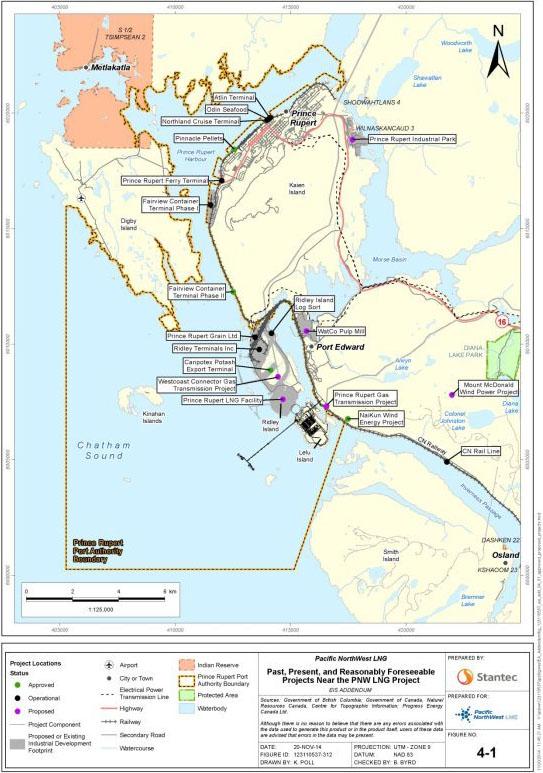
The Agency focused its cumulative effects assessment on four valued components: freshwater fish and fish habitat; marine fish and fish habitat (including species at risk and marine plants); marine mammals (including species at risk); and current use of lands and resources for traditional purposes. The Agency's rationale for including these valued components in the cumulative effects assessment was based on the following criteria: level of concern expressed by the public, Aboriginal groups, and government agencies; health, status or condition of the valued component; whether the cumulative effects are likely to occur; potential significance of cumulative environmental effects; and potential mitigation or follow-up.
7.3.2 Cumulative Effects – Freshwater Fish and Fish Habitat
Proponent's assessment of environmental effects
Air emissions of sulphur dioxide (SO2) and nitrogen oxides (NOx) from multiple projects within the Prince Rupert area may react with water and oxygen to form acidic compounds of sulfate (SO4) and nitrogen oxides (NOx) in freshwater bodies. Under some circumstances, acid deposition can lead to acidification and/or eutrophication of freshwater bodies [22]. Acidification and eutrophication can in turn lead to fish habitat loss and increased fish mortality. The B.C. Ministry of Environment has set a critical load for acid deposition of 150 equivalents per hectare per year (eq/ha/year). Above this critical load, B.C. Ministry of Environment suggests that freshwater bodies may be vulnerable to acidification and/or eutrophication and recommends further assessment.
Under the cumulative air emissions modelling scenario, the proponent identified exceedances of critical load for acid deposition in two areas within the boundaries of the regional assessment area: one on the western edge of Kaien Island (Area A), and one on Ridley Island (Area B) (see figure 4). Area A is located over the B.C. and Alaska Ferries terminal and the Fairview Terminal. Area B is located over Prince Rupert Grain Ltd., Ridley Island Coal Terminal, Canpotex, and Prince Rupert LNG. Under the modelled cumulative emissions scenario, acid deposition reaches a maximum predicted annual average of 251 eq/ha/yr in Area B, 101 units above the critical load threshold for acid deposition.
The proponent conducted a desktop study which identified six watercourses within Area A, which are considered unlikely to support any resident or anadromous fish populations. Area B contains a number of small watercourses, and at least one fish-bearing creek (Hays Creek).
The proponent characterized the residual cumulative effects as permanent, but with no measureable adverse effect on the function or use of fish habitat or reduction in the size of the fish population. The proponent characterized freshwater systems in the area as occurring in a viable/undisturbed ecosystem with high resiliency. The proponent concluded that because most of the watercourses potentially affected by acidification and eutrophication from cumulative effects are unlikely to support resident or anadromous fish populations, except for the headwaters of Hays Creek, the Project is not expected to contribute to a cumulative change in fish mortality or a net loss in fishery productivity. Therefore, the proponent concluded no significant cumulative effects on fish and fish habitat. The proponent proposed an acidification and eutrophication follow-up program to confirm this determination.
Figure 5: Areas of exceedance of critical load (cumulative scenario) (Stantec). Area labels added by the Agency.
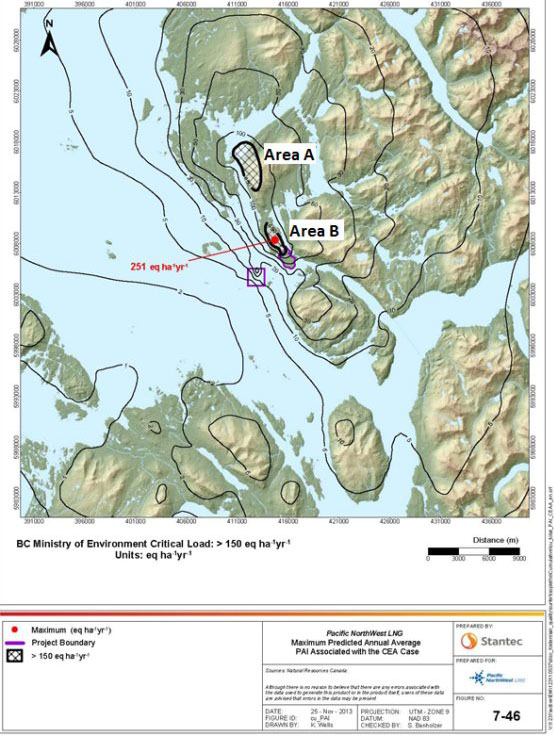
Comments received
Government Authorities
Comments were received from both federal and provincial authorities regarding the adequacy of the cumulative effects assessment for acidification and eutrophication of freshwater bodies. Environment and Climate Change Canada and the B.C. Ministry of Environment requested that a monitoring program for both Hays Creek and Wolf Creek systems be developed to address short and/or long-term cumulative effects from acid deposition. They also recommended further studies to determine the accuracy of the desktop review of potential fish habitat in areas of critical load exceedances under cumulative emissions scenarios, as they believe the analysis is data deficient. The B.C. Ministry of Environment suggested baseline water chemistry analysis of Alwyn Lake indicates that it is highly susceptible to acidification and eutrophication, and that other freshwater bodies within the regional assessment area are likely susceptible as well.
The proponent committed to conduct a follow-up program to verify predictions, and assess both Project and cumulative effects on freshwater bodies from deposition of acidic compounds. The proponent also committed to conducting baseline habitat use studies on fish-bearing streams and lakes within the regional assessment area, including Wolf Creek system, Hays Creek system, Alwyn Lake, and two headwater lakes on Kaien Island.
Aboriginal Groups
Both Lax Kw'alaams Band and Kitsumkalum First Nation requested that further assessment of acidification and eutrophication be conducted. Kitsumkalum First Nation expressed concern about the exceedance of critical load under the cumulative emissions scenario, and stressed the need for further analysis of cumulative effects. As mentioned above, the proponent has committed to a monitoring and follow-up program for potential acidification and eutrophication in the freshwater bodies identified.
Public
Members of the public expressed concern that multiple projects within the Prince Rupert area could lead to acid rain and acidification of freshwater bodies. The T. Buck Suzuki Foundation recommended that the cumulative effects of acidification from all proposed LNG projects be assessed by the B.C. Ministry of Environment, and that a comprehensive strategy be developed to address acidification issues.
Agency Analysis and Conclusions
The Agency notes that modelling results suggest critical load exceedances for acid deposition under the cumulative emissions scenario in two locations. There is some uncertainty with regards to the proponent's prediction of the cumulative effects of acid deposition in freshwater bodies in the regional assessment area as the proponent did not field-verify their desktop study of fish habitat, or conduct an effects assessment for any freshwater bodies in this area, with the exception of Alwyn Lake. The resiliency of the ecosystem is predicted to be high by the proponent; however, baseline water chemistry assessment of Alwyn Lake indicated that the lake is highly susceptible to acidification and eutrophication. There is also at least one creek system (Hays Creek) within the regional assessment area that is important habitat for numerous fish species.
The Agency has considered the mitigation measures proposed by the proponent, advice from expert federal authorities, and comments received from Aboriginal groups and the public, and identified the mitigation measures referenced in section 6.1 as necessary to limit emissions of SO2 and NOx and avoid cumulative impacts to freshwater fish and fish habitat. The Agency agrees with the proponent that a follow-up program is necessary to verify the prediction that acidification and eutrophication of freshwater bodies within the local assessment area would not occur as a result of Project or cumulative emissions. Further details about this program can be found in section 9.
The B.C. Ministry of Environment has announced plans to study the cumulative effects of existing and proposed industrial air emissions in the Prince Rupert airshed to help inform future decisions on industrial development, including proposed LNG facilities. The study will assess the impact of different emissions scenarios on surface water, soils, vegetation and human health. It is expected that the proponent would participate in this study.
The Agency concludes that the Project, in combination with past, present and future foreseeable projects, is not likely to result in significant adverse cumulative effects on freshwater fish and fish habitat, taking into account the implementation of mitigation measures and a follow-up program for acidification and eutrophication.
7.3.3 Cumulative Effects – Marine Fish and Fish Habitat including Species at Risk and Marine Plants
Proponent's Assessment of Cumulative Environmental Effects
The proponent determined that cumulative effects due to changes in sediment and water quality are not anticipated as Project dredging and disposal activities were not expected to overlap in both time and space with other projects. Sediment dredging and disposal activities for the Canpotex Potash Export Terminal planned within the Prince Rupert Port Authority boundaries (i.e. not at Brown Passage) could be concurrent with the Project. However the proponent described little potential for spatial overlap of the resulting suspended sediment plumes. Disposal of sediment from the Fairview Phase II Project, just north of Lelu Island, could overlap with disposal from the Project at Brown Passage. The proponent expected that regulators would establish timing windows for sediment disposal activities to avoid an overlap of suspended sediment plumes.
The proponent also identified potential cumulative effects of direct mortality or physical injury, including hearing loss and ruptured swim bladders as a result of underwater noise from pile installation and blasting, should the timing of construction for multiple projects overlap. The proponent determined that some invertebrates and sedentary or slow moving fish were likely to be injured or killed by construction activities, but that this would only occur in the area immediately around such activities. The proponent described affected species as locally abundant and likely to recolonize and recover via the creation of productive offsetting habitat.
The proponent also considered cumulative effects of behaviour change to marine fish due to underwater noise during blasting, dredging, pile driving, berthing, and shipping from multiple projects. The zone of behavioural avoidance for fish would vary depending on the species, the source level and frequency of noise generating activity for each project, and the degree of overlap of affected areas. The proponent noted that the extent of the overlap is not known. The proponent did not expect that behaviour changes would affect population viability for the affected marine species given their large geographic ranges. The proponent determined that no cumulative effects assessment was required for changes to fish habitat. The residual effects of the Project, taking into consideration the implementation of fish habitat offsetting measures, were described by the proponent as negligible; the proponent indicated that productivity within the area would be maintained.
The proponent concluded no significant residual cumulative effects because: there would be no changes to sediment or water quality that would result in a toxicological risk to aquatic life; there would not be a high likelihood of affecting fish and invertebrate population viability; and there would not be a high likelihood of causing mortality to a species at risk.
Comments Received
Government Authorities
Fisheries and Oceans Canada advised that potentially significant effects in the form of serious harm (as defined in the Fisheries Act) would be offset as required under the Fisheries Act for the Project and for other projects in the area. In reviewing future applications for serious harm to fish in the area, Fisheries and Oceans Canada will determine whether effects of those other projects can be offset, and how much offsetting would be required, taking into consideration the status of the fisheries.
The Prince Rupert Port Authority advised that arrivals and departures of vessels are staggered based on navigational safety concerns, not to reduce underwater noise. The Prince Rupert Port Authority has started to develop a Prince Rupert Port Authority Marine Mammal Management Plan, a component of which will be the monitoring and evaluation of marine noise. The Port Authority advised that resulting management actions with respect to the reduction or mitigation of marine noise may also be of benefit to marine fish.
The Prince Rupert Port Authority is developing a Port of Prince Rupert Dredged Sediment Management Guide through a working group for future projects with representatives from Metlakatla First Nation, other Aboriginal groups, and government agencies. The Guide would include alternate uses for sediment from dredging activities, identification of potential locations for disposal, and guidance on other sediment management issues.
Environment and Climate Change Canada continues to contribute to the work of the Sediment Management Working Group to be led by the Prince Rupert Port Authority. In addition, Environment and Climate Change Canada will continue to invite Aboriginal groups to join departmental staff conducting environmental effect monitoring related to approved disposal at sea activities at Brown Passage and will share the results.
Environment and Climate Change Canada continues to work with Aboriginal groups and relevant government agencies on the broader Cumulative Effects Monitoring Initiative to collaboratively develop an environmental monitoring pilot proposal in the Prince Rupert area.
Environment and Climate Change Canada advised that the timing windows within which sediment deposition is allowed, as defined in disposal at sea permits, should not be relied upon to manage cumulative effects.
Aboriginal Groups
Lax Kw'alaams Band and Metlakatla First Nation expressed concern about cumulative effects from any spatial or temporal overlap from multiple dredging and pile driving activities. Both have stated that there was a lack of evidence provided regarding cumulative effects on fish and fish habitat, particularly within the Skeena River estuary. Gitxaala Nation and Metlakatla First Nation both asserted that effects did not have to overlap in both time and space to be cumulative. Metlakatla First Nation requested that the proponent provide a schedule for dredging to ensure that temporal overlap with other projects is avoided and that they be involved in on-site monitoring and management of dredging and disposal activities. Kitsumkalum First Nation commented that the proponent should be required to self-govern the timing of disposal at sea activities to ensure no overlap with disposal from other projects.
Lax Kw'alaams Band and Kitsumkalum First Nation requested that the proponent conduct modelling to assess the cumulative effects of underwater noise to fish and marine mammal behavior from multiple projects in the Prince Rupert area. Kitsumkalum First Nation requested that a follow-up and monitoring program be implemented to address uncertainty regarding cumulative effects of underwater noise.
Lax Kw'alaams Band, Metlakatla First Nation, and Gitxaala Nation requested that a cumulative risk assessment be completed to assess the risk that infrastructure associated with multiple projects could lead to oceanographic changes that could destabilize Flora Bank.
Lax Kw'alaams Band, Metlakatla First Nation, and Gitxaala Nation also expressed disagreement with the limited size of the regional assessment area used for the assessment of cumulative effects on marine resources.
To provide multi-project oversight, Lax Kw'alaams Band asserted that the development of an independent environmental monitoring system for the Prince Rupert Harbour area was essential and stated that it must be engaged in the design and implementation of this program.
Public
World Wildlife Fund Canada expressed concern about the general methodology used in conducting cumulative effects assessment for marine species. It stated that the cumulative effects assessment should be conducted for multiple projects as well as for multiple concurrent effects including mortality/injury from blasting, behavioral changes, and chemical contamination. It stated that the assessment relies too heavily on qualitative analysis. World Wildlife Fund Canada expressed particular concern over the assessment of cumulative effects from underwater noise, including noise from blasting, pile driving, dredging, construction vessel movement, shipping, and berthing, and disagreed with the assertion that a cumulative effects assessment for fish habitat was not required..
Agency Analysis and Conclusion
The Agency finds that effects on marine fish and fish habitat as a result of Project effects interacting with effects from other projects are possible. There are a number of initiatives and controls that would manage these effects, including the Prince Rupert Port Authority's Dredged Sediment Management Guide to provide guidance for sediment disposal.. Furthermore, it is expected that many of the other proposed projects would undergo an EA and be required to abide by conditions to mitigate potential effects.
With regard to effects on fish habitat for the Project and for other projects in the area, potentially significant effects in the form of serious harm (as defined in Fisheries Act) would be offset as required by Fisheries and Oceans Canada under the Fisheries Act. In reviewing future applications for serious harm to fish in the area, Fisheries and Oceans Canada will determine whether effects can be offset, and how much offsetting would be required, taking into consideration the status of the fisheries.
The Agency concludes that the Project, in combination with past, present and future foreseeable projects, is not likely to result in significant adverse cumulative effects on marine fish and fish habitat, taking into account the implementation of mitigation measures and a follow-up program.
7.3.4 Cumulative Effects – Marine Mammals
Proponent's assessment of environmental effects
The proponent noted that cumulative effects associated with collisions between marine mammals and LNG carriers or other shipping vessels could result in direct mortality or physical injury of marine mammals. All shipping traffic to Prince Rupert will use shipping lanes from the open ocean, around Triple Island on the west side of Chatham Sound, and across the Sound. The Prince Rupert Port Authority expects that shipping would increase from an estimated 500 [23] to 2000 ships annually by 2025, of which the Project would account for 350. The proponent concluded that mitigation measures (e.g. speed profiles that slow around Triple Island, course alterations) expected of all projects would generally limit the likelihood of mortalities and population level effects on marine mammals. For individuals of any species at risk, the proponent determined that there is not a high likelihood of death as a result of a vessel collision during the life of the Project.
The proponent also identified potential cumulative effects of direct mortality or physical injury such as from hearing loss due to underwater noise from pile installation and blasting during construction. These activities are likely to overlap spatially and temporally with construction of the Canpotex Potash Export Terminal on Ridley Island. Given the abundance of soft sediment in the area, the proponent stated that it is likely that construction of all projects would be able to use less noisy vibratory hammers for pile installation. If impact pile driving were to occur concurrently there would be larger areas where marine mammals especially harbour seals could experience hearing loss. The proponent concluded that injury to other marine mammals is possible but not likely as other similar projects are expected to implement mitigation measures such as bubble curtains and less noisy vibratory hammers instead of impact hammers to reduce effects on marine mammals.
The proponent also considered cumulative effects of behaviour change due to underwater noise from blasting, dredging, and pile driving during construction, and berthing, and shipping during operations. The proponent stated that given the expected increase in underwater noise from multiple projects in the area, behaviour could be affected over larger areas and for longer durations when other projects are taken in to account. The loud noises during construction and operations could lead to avoidance of the area, increase stress levels and interfere with marine mammals' ability to find prey or effectively communicate. The zone of behavioural avoidance would vary depending on the species, the level and frequency of noise generated, and the degree of overlap of affected areas.
The proponent identified harbour porpoise as particularly sensitive to acoustic disturbance, and indicated that the Project will contribute to cumulative effects causing changes in behaviour to harbour porpoise during the construction phase. However, the proponent indicated that alternative habitat is available in southern Chatham Sound (around Smith and Porcher Islands), Goschen Island) and Hecate Strait. The proponent does not expect that behaviour changes would affect population viability for the affected marine species given their large geographic ranges, and the availability of alternative habitat.
The proponent indicated that mitigation measures implemented as part of the Project are expected to reduce the magnitude of effects on marine mammals, and that other projects in the region have been or are likely to be required to implement similar mitigation measures. The proponent does not expect that residual cumulative effects to marine mammals would result in mortality to species at risk or affect population viability for the affected marine species given their large geographic ranges, and the availability of alternative habitat. The proponent concluded cumulative effects on marine resources, including marine mammals, would be not significant.
Comments received
Government Authorities
Fisheries and Oceans Canada agreed with the proponent that concurrent construction and operation of the Project with present and future developments may increase the risk of marine mammal injury, death, and behavioural change. It advised that there is uncertainty regarding the potential effects on marine mammal populations because of knowledge gaps regarding: the current rate of marine mammal injury and death resulting from shipping and marine development; marine mammal population densities; the importance of the area potentially affected by the Project to marine mammals; and the effectiveness of mitigation measures. Fisheries and Oceans Canada expressed particular concern regarding effects to harbour porpoise, given its susceptibility to acoustic disturbance, its status as a federal species at risk, its extensive use of the project area year-round, and uncertainty regarding the suitability of alternative habitat in the area. It indicated that after the implementation of mitigation measures there would remain a medium to high risk of the Project having significant adverse effects to harbour porpoise.
As part of its ongoing environmental sustainability improvements, the Prince Rupert Port Authority has started to develop a Prince Rupert Port Authority Marine Mammal Management Plan to reduce risks to marine mammal populations from port operations, including underwater noise and vessel collisions. The Port Authority will update its Practices and Procedures with any new requirements applicable to vessels within the port limits of Prince Rupert.
The Pacific Pilotage Authority advised that it will work with the Prince Rupert Port Authority to develop speed profiles required for vessels under pilotage to the Port, as needed. It indicated that speeds of vessels while under pilotage are at the discretion of the pilot.
Aboriginal groups
Gitga'at First Nation, Lax Kw'alaams Band, Gitxaala Nation, and Metlakatla First Nation expressed concern about the cumulative impacts from ship strikes to whales, dolphins, and porpoises. Metlakatla First Nation expressed particular concern about vessel strikes and underwater noise around Triple Island where vessels would converge to take on Pilotage Authority pilots. Lax Kw'alaams Band raised concern about the cumulative effects of vessel traffic on marine mammals in Porpoise Channel near the Materials Offloading Facility. Gitxaala Nation and Metlakatla First Nation requested that reduced vessel speed in the area under pilotage be included as a mitigation measure to prevent vessel strikes.
Gitxaala Nation, Lax Kw'alaams Band, and Kitsumkalum First Nation expressed concern that the cumulative effects of underwater noise on marine mammals from construction were assessed by the proponent as ‘not significant' but with a low level of certainty. Lax Kw'alaams requested that a comprehensive, region-wide study be conducted on the cumulative effects from underwater noise and increased suspended solids to marine mammals. They expressed that this cumulative effects study should include measures for adaptive management, and should be implemented in consultation with Aboriginal groups and federal authorities.
Metlakatla First Nation expressed concern about the criteria used to assess significance as it believed that if marine mammals leave the assessment area permanently due to cumulative effects from multiple projects it should be considered a significant effect, even if it does not threaten population viability.
To provide multi-project oversight, Lax Kw'alaams asserted that the development of an independent environmental monitoring system for the Prince Rupert Harbour area was essential and stated that it must be engaged in the design and implementation of this program.
Gitxaala Nation, Metlakatla First Nation and Gitga'at First Nation indicated that the use of the local assessment area as the spatial scope for the cumulative effects assessment for marine mammals was inadequate, and that the proponent may underestimate cumulative effects from vessel noise and vessel strikes, and the effects of multiple, interacting disturbances.
Public
World Wildlife Fund Canada expressed concern about the cumulative effects assessment for marine mammals. It stated that the cumulative effects assessments should be conducted for multiple projects as well as for multiple concurrent effects, including mortality/injury from blasting and/or ship strikes, behavioral changes that may result in decreased ability to feed/communicate, and chemical contamination.
World Wildlife Fund expressed particular concern over the effects from underwater noise from multiple activities across multiple projects, including blasting, pile driving, dredging, construction vessel movement, shipping and berthing. It indicated that the manner in which these stressors combine temporally and spatially to impact valued components was not assessed adequately by the proponent.
Agency Analysis and Conclusions
Cumulative effects on marine mammals include impacts from vessel collisions and underwater noise. Many of the marine mammals that seasonally frequent the area are federally listed as threatened species at risk (humpback whale, Bigg's killer whale, northern resident killer whale). Although no marine mammal critical habitat as defined in the Species at Risk Act has been identified, Chatham Sound is identified as important to humpback whales, northern resident killer whales, and sea lions in Fisheries and Oceans Canada's Pacific North Coast Integrated Management Area Atlas.
The Agency finds that the increase in large vessel traffic in the Prince Rupert Port to 2000 vessels a year by 2025 could be reasonably expected to increase the likelihood of vessel collisions with marine mammals. The Agency agrees with Fisheries and Oceans Canada that the level of risk is uncertain given the currently available site-specific information regarding abundance of marine mammals and their spatial and temporal use. LNG vessels en route to and from the marine terminal berths would be required to respect speed profiles established by the Prince Rupert Port Authority, the pilots, or other regulatory agencies. The Agency expects risks to marine mammals to be taken into consideration in the development of speed profiles.
Given the number of large, industrial projects proposed in the Prince Rupert area, underwater noise along the east side of Chatham Sound could increase, potentially resulting in cumulative effects of physical injury, such as permanent hearing loss to marine mammals. Underwater noise would likely be greatest and most continuous during construction activities (e.g. blasting and impact pile driving), which could occur for multiple projects close together or at the same time in the next decade. Physical injury effects during construction could be reduced through implementation of a marine mammal observation program in which the proponent maintains a safety radius and stops noisy activities when marine mammals come too close. Underwater noise from vessels transiting and berthing, which could continue daily for decades, is less likely to result in permanent hearing loss.
Regarding potential marine mammal behavioural changes, the Agency notes the uncertainty regarding how marine mammals would respond to the increase in underwater noise, including if and for how long they would avoid an area, the effectiveness of mitigation measures, and the suitability of alternative habitats described by the proponent. With likely continued development of the Port of Prince Rupert, it is uncertain if marine mammals would avoid the area permanently, avoid the area temporarily and return, or remain in the area by adapting to new conditions. The Agency agrees, however, that the implementation of mitigation measures by future projects would help alleviate any adverse significant effects for marine mammals.
Given the comparatively high susceptibility of harbour porpoise to acoustic disturbance and their year-round abundance in the shallow waters around the Project area, the residual cumulative effects to harbour porpoise from underwater noise during construction are expected to be more pronounced when compared to other marine mammals. While the proponent has identified alternative habitat for harbour porpoises, including Western Hecate Strait, and around Smith, Porcher, and Goschen Island, Fisheries and Oceans Canada are uncertain whether these habitats are suitable. Considering that overlapping Projects are expected to lead to behavioural effects that occur over a larger area and for a longer period of time, it is also not clear whether these habitats would remain suitable. The Agency concurs with Fisheries and Oceans Canada advice and has concluded that the Project would result in likely significant adverse project effects to harbour porpoise. Given this conclusion, the Agency determines that any further effects from other projects or activities likely to occur in combination with the already significant adverse effects of this Project would result in likely significant adverse cumulative effects to harbour porpoise.
Initiatives underway by the Prince Rupert Port Authority will aid management of cumulative effects on marine mammals. The Agency expects that development of the Prince Rupert Port Authority Marine Mammal Management Plan will improve knowledge of marine mammal use and dependency on the harbour area, that cumulative effects on marine mammals will be considered by the Port's Environmental Stewardship Committee, and that implementation of the updated Practices and Procedures will help to reduce effects of underwater noise to marine mammals. The Agency anticipates the Port Authority will involve federal experts and other stakeholders that could provide valuable information and expertise (e.g. Aboriginal groups, proponents of LNG terminals) in the development of the marine mammal program. The Agency further expects that the proponent would be required to adhere to mitigation measures set by the Port Authority as a condition of the lease.
Given the uncertainties with regard to the cumulative effects assessment recognized by the Agency, the proponent and Fisheries and Oceans Canada, a follow-up program is necessary to verify predictions regarding cumulative effects on marine mammals, including reporting of marine vessel strikes and monitoring and reporting of marine mammal abundance and habitat use during operations. Should the follow-up program identify concerns related to the disruption of marine mammals' ability to carry out one or more life processes , further mitigation measures would be necessary following consultation with Fisheries and Oceans Canada and the Prince Rupert Port Authority. Furthermore, the proponent should participate, at the request of federal authorities, in any regional initiatives relating to cumulative effects monitoring and the management of marine shipping that may occur during the construction and operation phases of the Project.
The Agency concludes that the Project, in combination with past, present and future foreseeable projects, is not likely to result in significant adverse cumulative effects on marine mammals overall, taking into account the implementation of mitigation measures and a follow-up program, as well as the marine mammal management program initiated by the Prince Rupert Port Authority that would help manage these effects. However, the Agency concludes that the Project is likely to result in significant adverse cumulative environmental effects to harbour porpoise, given its susceptibility to behavioural effects from underwater noise, its current at risk status, its extensive use of the project area year-round, and the uncertainty of suitable alternative habitat.
7.3.5 Cumulative Effects – Current Use of Lands and Resources for Traditional Purposes
Proponent's Assessment of Cumulative Environmental Effects
The proponent said that the Project's residual effects on the current use of lands and resources for traditional purposes could interact cumulatively with the effects of other projects or activities involving either offshore construction or marine traffic, or both. This could interfere with Aboriginal users' marine-based access to sites where traditional activities are practiced and influence the timing of when these sites are used. For example, the Westcoast Connector and Prince Rupert Gas Transmission Projects could result in added, but temporary barriers and inconvenience (while the pipelines are being constructed in marine waters) for Aboriginal users travelling from Port Edward into Chatham Sound to access traditional activity sites. The proponent noted that the water lots assigned to both the Project and the proposed Prince Rupert LNG Project on Ridley Island, located on the opposite side of Porpoise Channel, have been designed to maintain full access to the channel and not overlap, should the two construction periods occur at the same time. As such, access restrictions to and from Porpoise Harbour are not anticipated.
The proponent indicated that the Prince Rupert Port Authority would manage the number of vessels from other proponents that have the potential to overlap during construction activities with vessels from the Project. The Project's contribution to increased marine shipping within the Prince Rupert harbour's limits would be one additional LNG carrier per day (or 350 LNG carriers per year) at full build out within existing shipping lanes between Lelu Island and Triple Island. The proponent concluded that the Project would incrementally add to interference with Aboriginal people's marine-based access to preferred locations where traditional activities are practiced.
The Project's residual effects on the availability of waters and resources on which the practice of traditional activities depend could also act cumulatively with the effects of other past, present and reasonably foreseeable projects or activities. For example, incremental industrial development may interfere with the availability of sites available for fishing. The proponent noted that the Project is not expected to contribute to cumulative effects on fish habitat and, as a result, fishing resources, because of Project-specific mitigation measures, including fish habitat offset measures. Cumulative effects on marine fish are addressed in section 7.3.3. According to the proponent, cumulative effects are anticipated to affect the quantity of marine mammals available for harvest by Aboriginal peoples in their preferred harvesting locations, but these effects are not predicted to have an effect on population viability or general availability of marine mammals for traditional harvesting within the region. Displacement of marine mammals from Aboriginal users' preferred harvesting locations may contribute to cumulative effects on their harvesting success and the effort involved in harvesting activities. Cumulative effects on marine mammals are addressed in section 7.3.4.
According to the proponent, the Project's contribution to cumulative effects on change in habitat, mortality, and alteration of movement of terrestrial wildlife and marine birds would be local and would affect only a small portion of the regional population that is available for traditional harvesting. The Project's contribution to overall development within the regional assessment area for terrestrial wildlife and marine birds is 175 ha (or 0.1 percent). Similarly, while the Project would result in the loss of traditional use plants on Lelu Island, these losses would represent very small proportions of the total amount of these vegetation communities within the regional assessment area. Removal of Lelu Island as a gathering site for traditional use plants would be partially mitigated through the incorporation of traditional use plants in wetland compensation projects and trail or parks improvement initiatives to facilitate access to restored or created wetlands in the Prince Rupert area. The proponent noted some uncertainty with regard to how other proposed projects may cumulatively affect traditional use gathering locations other than Lelu Island and access to these locations.
The Project's facility on Lelu Island, the marine terminal and LNG carriers, together with the effects of other operational, approved, and reasonably foreseeable projects or activities within the regional assessment area would result in alterations to the sensory environment, including to visual quality. However, the proponent stated that these developments largely occur within the boundaries of the Port of Prince Rupert, which is scheduled for current and future industrial expansion. The proponent plans to mitigate the Project's contribution to cumulative sensory disturbances through measures designed to limit increase of noise and ambient light levels.
Taken together, the cumulative reductions in access and availability of marine-based sites and resources (marine mammals) and increase in sensory disturbances may affect Aboriginal users' degree of satisfaction related to the practice of traditional activities and the ability of Aboriginal users to gather and share traditional knowledge associated with the sites and activities being impacted. The proponent also noted that Aboriginal social cohesion is expected to experience cumulative adverse effects due to cumulative reductions in opportunities for families and others to practice traditional activities together and for Aboriginal peoples to trade and share country foods.
The proponent stated that the Construction Coordination Committee and the Port Operations Committee, led by the Prince Rupert Port Authority, and ongoing land and marine use planning processes, in which Aboriginal groups are involved, would help to mitigate cumulative effects on current use of lands and resources for traditional purposes. The Port Authority would require all proponents to submit information related to their planned activities, including sequencing, numbers of vessels, traffic routes, fuel requirements, and timeframes, in order to prevent or resolve conflicts between overlapping activities. According to the proponent, land and marine use planning processes can help to mitigate effects on Aboriginal people's use of lands and resources through communication during construction and operation and future water use planning and zoning. The proponent also agreed to participate in government-led cumulative effects management processes to address issues of concern to Aboriginal groups.
The proponent defined a significant adverse cumulative effect on the current use of lands and resources for traditional purposes as one that would affect the viability or sustainability of the traditional use of lands and resources by Aboriginal people within the regional assessment area. The proponent concluded that cumulative effects on the current use of lands and resources for traditional purposes would not be significant; however, the proponent noted a high degree of uncertainty with regard to how other projects considered in the cumulative effects assessment may cumulatively affect current Aboriginal traditional use of lands and resources. The proponent also acknowledged that confidence in its predictions can be affected by the fact that human behaviours are difficult to predict.
Comments Received
Aboriginal Groups
All Aboriginal groups noted that their ability to practice their culture and the resources on which the practice of their traditional activities depends have been considerably diminished by existing development within their traditional territories, particularly in the Prince Rupert area. They stated that the effects from the Project, in conjunction with other existing and foreseeable industrial developments, would result in cumulative environmental effects on waters, lands, and resources that are of importance to Aboriginal peoples and in additional serious effects on their members' ability to harvest resources within the Project area, as they have done for generations. Gitga'at First Nation noted the need for an oversight mechanism to insure that day-to-day transits of all LNG carriers and other vessels minimize disruptive interactions with local marine traffic and marine activities and, to the extent reasonable, harmonize with the marine transportation activities of local Aboriginal groups and other communities.
Lax Kw'alaams Band stated that uncertainties in the assessment of the effects of the Project on marine resources translate into uncertainties in the assessment of cumulative effects on the current use of lands and resources for traditional purposes. Metlakatla First Nation expressed concerns that the general availability of marine species on which the practice of its members' traditional activities depend would be affected as various marine species relocate from the area due to cumulative effects of multiple overlapping projects. Lax Kw'alaams Band stated that the increased cumulative risks of vessels navigating through the Prince Rupert area and introducing alien or invasive species through exchange of ballast waters could adversely affect marine resources on which the livelihoods, local economy, health and well-being of its members depend.
Kitsumkalum First Nation also stated that the possibility of multiple years of offshore construction activities in the Prince Rupert area and Skeena River estuary could cause cumulative effects on water quality or fish and fish habitat that remain through several life cycles of fish species of importance for the practice of traditional activities by Aboriginal people. Given these implications, Kitsumkalum First Nation recommended that a more in-depth cumulative effects assessment for changes in sediment and water quality and changes to fish and fish habitat be provided and that additional mitigation measures be presented.
Kitsumkalum First Nation also noted that cumulative effects on the habitat of non-harvested species that may hold an important spiritual connection for Aboriginal peoples, such as killer whales, could be detrimental to Aboriginal peoples' sense of place and relationships with the lands and waters.
Metlakatla First Nation expressed concerns that increased marine activities from the Project, in combination with marine-based activities from other existing, proposed or foreseeable development, could lead to diversion of marine traffic through Metlakatla Pass (located north-east of Digby Island) in order to avoid navigation interferences and obstructions in and around Chatham Sound and Porpoise Channel. Metlakatla Pass is an important location for Metlakatla members to practice traditional activities and increased traffic through the Pass could affect members' navigation and safety and the resources on which these traditional activities depend. The proponent indicated there was no evidence to suggest diversion of traffic through Metlakatla Pass and noted that going through Metlakatla Pass would require more time and increase costs for fuel. It stated that the Project's contribution to cumulative effects is unlikely. The proponent also noted that Prince Rupert Port Authority's navigation procedures and policies, such as those related to vessel speeds, would apply to any vessels that use the Pass, and this would help alleviate the safety and erosion concerns that Metlakatla First Nation has raised. The proponent also reported that the Prince Rupert Port Authority monitors speed and enforces speed limits within its boundaries, especially during high traffic months in the summer.
Metlakatla First Nation stated that the proponent's assessment of cumulative effects was deficient because it did not take into consideration the incremental potential for cumulative effects to become significant if several projects, all with minimal residual impacts, move forward at the same time.
Agency Analysis and Conclusion
The Agency determined that there would be residual cumulative effects of the Project on the current use of lands and resources within the regional assessment area. These residual effects are described in section 6.10.
The Agency agrees with the proponent's analysis and proposed mitigation measures for the following reasons:
- The Project's contribution to increased interference with navigation would be minimized by the measures included in section 6.10, including designing the suspension bridge and Lelu Island bridge to allow for the passage of small vessels underneath and implementing a Marine Communications Plan.
- The number of vessels from various projects that have the potential to overlap during construction activities was not available to the proponent for the EA process. However, potentially affected Aboriginal groups would be provided the opportunity to participate in the Prince Rupert Port Authority led Construction Coordination Committee and Port Operations Committee. The proponent would be required by the Port Authority to participate in the Construction Coordination Committee and provide information to the Port Authority on their activities in order to resolve conflicts and coordinate the implementation of mitigation measures related to navigation.
- The Agency concludes that the Project, in combination with past, present and future foreseeable projects, is not likely to result in significant adverse cumulative effects on marine fish and fish habitat, taking into account the implementation of mitigation measures and a follow-up program(see section 7.3.3 on cumulative effects on marine fish and fish habitat).
- The Agency concludes that the Project, in combination with past, present and future foreseeable projects, is not likely to result in significant adverse cumulative effects on marine mammals, except harbour porpoise, taking into account the implementation of mitigation measures and a follow-up program, as well as the marine mammal management program initiated by the Prince Rupert Port Authority that would help manage these effects. The Agency concludes that the Project is likely to result in significant adverse cumulative environmental effects to harbour porpoise (see section 7.3.4 on cumulative effects on marine mammals). The Agency did not receive information to the effect that harbour porpoise is a species used for traditional purposes by Aboriginal peoples in the Project area.
- The Agency acknowledges that displacement of marine resources from preferred harvesting sites due to cumulative effects could adversely affect the experience of Aboriginal users. For example, displacement of marine resources from preferred harvesting may increase the effort needed to reach other unaffected harvesting sites and decrease the satisfaction level of Aboriginal users (including their ability to gather and share traditional knowledge associated with their primary harvesting sites). The Agency acknowledges that it is unknown whether Aboriginal users would be willing to relocate their activities to other harvesting sites.
- Development features currently occupy 1,944 ha (or 1 percent) of the regional assessment area for terrestrial wildlife and marine birds, and an additional 478 ha of development is planned in the reasonably foreseeable future. The Project's contribution to overall development within the regional assessment area for terrestrial wildlife and marine birds would be 175 ha (or 0.1 percent). The contribution of the Project to cumulative effects on terrestrial resources would only affect small portions of their regional populations and they would remain available for harvesting within the region. The Agency acknowledges that it is unknown whether Aboriginal users would be willing to relocate their activities to other harvesting sites.
- Lelu Island and Ridley Island are designated in the Prince Rupert Port Authority 2020 Land Use Management Plan as potential sites for future industrial development. The Agency recognizes that this designation can lead to the degradation of visual quality. The Project's contribution to decreased visual quality would be minimized through the maintenance of a vegetation buffer around Lelu Island.
The Agency notes that a number of initiatives to manage cumulative effects are planned for the Prince Rupert area, including the Prince Rupert Port Authority's Dredged Sediment Management Guide to provide guidance for sediment disposal, the Prince Rupert Port Authority Marine Mammal Management Plan to reduce risks to marine mammal populations from port operations and Environment and Climate Change Canada's plans to develop a cumulative effects monitoring program in the Skeena area. These initiatives relate to elements of the environment that are of importance for the continued practice of traditional activities in the region, including the health of the marine environment. The Agency anticipates that Aboriginal groups, which can provide valuable information and expertise, would be involved in the development of these initiatives.
The Agency concludes that the Project, in combination with past, present and future foreseeable projects, is not likely to result in significant adverse cumulative effects on the current use of lands and resources for traditional purposes, taking into account the implementation of mitigation measures.
8 Impacts on Potential or Established Aboriginal Rights or Title
8.1 Potential or Established Aboriginal Rights or Title in the Project Area
The Agency identified six Aboriginal groups that assert potential or established Aboriginal rights or title on Lelu Island and on the marine environment surrounding Lelu Island, in the Prince Rupert area. Lax Kw'alaams Band, Metlakatla First Nation, Gitxaala Nation, Kitsumkalum First Nation, Kitselas First Nation, and Gitga'at First Nation shared their concerns with the Agency about how the Project could adversely impact their potential or established Aboriginal rights or title. The following is a summary of the potential or established Aboriginal rights or title for each group in the area of the Project, based on information received through consultation with the Aboriginal groups. The Project is located in an area with overlapping assertions to rights and title from five Aboriginal groups: Lax Kw'alaams Band, Metlakatla First Nation, Gitxaala Nation, Kitsumkalum First Nation, and Kitselas First Nation. Gitga'at First Nation also asserts Aboriginal rights, but no title, to the same area.
Lax Kw'alaams Band 's traditional territory, in which it claims Aboriginal rights (including Aboriginal title), includes all of the lands and waters between the land surrounding the tributaries of the Skeena River, the height of land east of the Zymoetz River, and the Kitsumkalum River. To the west, its traditional territory includes Nass Bay and the Nass River. To the north, its traditional territory includes Wales and Pearse Islands and the Dundas and Stephens Islands groups, as well as lands and waters at the mouth of the Skeena River stretching south along Grenville Channel. Lax Kw'alaams Band claims Aboriginal rights within the Prince Rupert Harbour area. Regular use and occupation by Lax Kw'alaams ancestors has resulted in an Aboriginal title claim to Lelu Island and Flora Bank within the Prince Rupert Harbour based on their asserted historic and current use and occupation.
Metlakatla First Nation 's traditional territory, in which it claims Aboriginal rights (including Aboriginal title), extends from the coastal islands in eastern Hecate Strait in the west to Lakelse Lake near Terrace in the east and from the Portland Canal and Observatory Inlet in the north to the headwaters of the Ecstall River in the south. Metlakatla First Nation's asserted traditional territory also includes the lower portions and the mouth of the Skeena River and its tributaries. Lelu Island is in the heart of Metlakatla First Nation's asserted traditional territory, and the lands and waters on, and surrounding, Lelu Island have long-standing traditional and current use by Metlakatla members.
Gitxaala Nation 's traditional territory, in which it claims Aboriginal rights over the lands, waters, and resources based on its laws, oral history, and customs, extends between the Nass River, the coastal islands (just north of Kitasu Bay), the marine territories of the Haida Nation, and the mainland shore of Grenville Channel. Gitxaala Nation also claims Aboriginal rights or title to the Prince Rupert Harbour area, including Lelu Island.
Kitsumkalum First Nation 's traditional territory includes the areas surrounding the Kitsumkalum, Zymacord and Cedar watersheds. It claims the use of areas outside these territories as seasonal camps, including Lakelse River, Cheweanlaw, Kiwnitsa (Skeena River), Ecstall River, and locations along Grenville Channel, Edy Pass, Stephens Island, Work Channel, Nass River, and Chatham Sound. Kitsumkalum First Nation asserts shared territory down to Low Inlet in Grenville Channel and Cape George in the Hecate Strait, stretching north to the Alaska and Nisga'a Nation borders. Kitsumkalum First Nation also claims that it holds Aboriginal rights and title to Lelu Island and all the lands covered by the Project and that its members continue to exercise their Aboriginal rights within and around the Prince Rupert Harbour area and larger coast for subsistence, cultural, and economic purposes.
Kitselas First Nation 's traditional territory includes the watersheds of the Skeena and Kitimat Rivers, from Lorne Creek in the east to the Skeena and Kitimat estuaries. Kitselas First Nation asserts that it has traditional harvesting areas in coastal areas, in the lower Skeena River and the Skeena estuary, and in the Nass watershed. Kitselas First Nation also claims Aboriginal title to its entire asserted traditional territory based on its exercise of land and resource management jurisdiction over the entire area.
Gitga'at First Nation 's traditional territory extends to the north along Douglas Channel, bisects Hawkesbury Island, extends south along the height of land draining into Ursula Channel, then crosses Princess Royal Island and incorporates Aristazabal Island as it extends out to the Pacific Ocean. To the northwest it bisects Campania Island and then proceeds north along the height of lands separating Pitt Island and Grenville Channel. It then extends some distance up Grenville Channel before joining up with its northern boundary. Gitga'at First Nation also asserts Aboriginal rights to use traditional sites and to harvest traditional marine and terrestrial food in the Prince Rupert Harbour area.
In addition to the above Aboriginal groups, Aboriginal groups with traditional territories located upstream of the Project, including Gitxsan First Nation, Gitanyow First Nation, Takla Lake First Nation, and the Wet'suwet'en Nation, expressed concern regarding the potential environmental effects that the Project may cause to salmon that migrate throughout the Skeena watershed, and the impacts that any such effects may have on these groups' potential or established Aboriginal right or title. The Agency considered these concerns as part of the environmental effects assessment of the Project related to marine resources and potential impacts to the practice of marine fishing.
Gitanyow First Nation's traditional territory is located approximately 150 km northeast of the Project, within the Skeena watershed, in an area that includes portions of the Kispiox River and Kitwanga River (which are tributaries of the Skeena River). Gitanyow First Nation expressed concern that the Kitwanga sockeye salmon, a stock already affected by over fishing and habitat degradation and vital to their asserted Aboriginal rights, would be affected further by the Project.
Gitxsan Nation 's traditional territory is located approximately 130 km northeast of the Project, within the Skeena watershed, in an area that includes the upper reaches of the Skeena River and Nass River. Gitxsan Nation expressed concern that the Project would affect traditional fisheries and the exercise of their asserted Aboriginal rights.
Takla Lake First Nation 's traditional territory is located approximately 250 km east of the Project, within the Skeena watershed, in an area that includes Bear Lake and Sustut Lake. Takla Lake First Nation expressed concern that the Project would affect traditional fisheries and the exercise of their asserted Aboriginal rights.
Wet'suwet'en Nation 's traditional territory is located approximately 140 km east of the Project, in an area that overlaps, in part, with the Skeena watershed. Wet'suwet'en Nation expressed concern that the Project would affect traditional fisheries and the exercise of their asserted Aboriginal rights.
8.2 Potential Adverse Impacts of the Project on Potential or Established Aboriginal Rights or Title
The Project has the potential to cause environmental effects, as defined under CEAA 2012, that may adversely impact potential or established Aboriginal rights or title related to the practice of marine fishing, harvesting and hunting, and terrestrial hunting, trapping, and traditional use plant gathering. A summary of potential impacts to potential or established Aboriginal rights or title is presented below. Potential environmental effects, as defined under CEAA 2012, on Aboriginal peoples within the context of health and socio-economic conditions, current use of lands and resources for traditional purposes, physical or cultural heritage, and effects on historical, archaeological, paleontological or architectural sites or structures are discussed in greater detail in sections 6.9 to 6.12. Appendix 11.6 provides a table summarizing key Aboriginal concerns.
Impacts to the practice of marine fishing, harvesting, and hunting
While the ability would remain for Aboriginal users to navigate in the waters surrounding Lelu Island and along the shipping routes to access marine traditional activity sites, Project-related changes in the availability of and access to marine fishing, harvesting and hunting sites around Lelu Island could lead Aboriginal peoples to adjust the means and timing of these practices and expend increased effort to reach alternate sites. While Aboriginal peoples would not be precluded from navigating alongside Project-related vessels to reach marine traditional activity sites, it is unknown whether Aboriginal peoples would be willing to access alternate sites, or navigate through the Project area because of perceived safety risks and decrease in the quality of the experience related to the presence of an industrial landscape. Through degradation of the sensory environment, the Project may also affect Aboriginal peoples' degree of satisfaction when practicing marine fishing, harvesting, and hunting. Taken together, these impacts may cause a loss of the traditional knowledge, as identified in the traditional use and traditional knowledge studies considered by the proponent in the EA, associated with these sites and with marine fishing, harvesting, and hunting practices.
The Agency received information from Aboriginal groups regarding the practice of hunting and gathering rights on Lelu Island but the Agency understands that, there is minimal hunting and gathering occurring on Lelu Island at the moment. The Agency also received minimal information with respect to uniqueness of Lelu Island relative to other preferred harvesting locations for hunting and plant gathering. Nonetheless, the loss of Lelu Island as a hunting and gathering site for the life of the Project would be permanent and may affect the intergenerational transfer of traditional knowledge, specifically knowledge associated with the practice of these activities on Lelu Island. Species would remain available for marine fishing, harvesting, and hunting in the area because the viability of local or regional populations would not be affected by Project-related activities, but harvested species may not be available in the preferred locations and at the preferred times Aboriginal peoples practice their activities, including Lelu Island which has been identified as an area of important habitat based on traditional knowledge. Sections 6.6 and 6.7 address environmental effects on marine fish and fish habitat and marine mammals, respectively, which would impact the practice of marine fishing, harvesting, and hunting.
Impacts to the practice of terrestrial hunting, trapping, and traditional use plant gathering
Lelu Island would not be accessible for the life of the Project for the Aboriginal peoples who may currently be using the island for traditional use related to terrestrial hunting, trapping, and traditional use plant gathering.
Effects from vegetation clearing on terrestrial resources would be small in scale relative to the amount of undisturbed ecosystems in the region. Harvested terrestrial and bird species would remain available for harvesting in the area because the viability of local populations would not be affected. Sections 6.3, 6.4 and 6.8 address environmental effects on vegetation, migratory birds, and terrestrial species at risk, respectively, which would impact the practice of terrestrial hunting, trapping, and traditional use plant gathering.
Impacts to cultural integrity
The Project would remove approximately 300 of the 550 Culturally Modified Trees inventoried on Lelu Island to date. These Culturally Modified Trees have high cultural value for Aboriginal groups as symbols of their continued past and current occupancy of the area, and as such may impact assertions of rights or title to Lelu Island. As well, Aboriginal groups considered that not maintaining Lelu Island intact may adversely affect their governance structure which depends on preserving the integrity of the cultural and physical landscape which they govern. The remaining Culturally Modified Trees, those that are not required to be removed in order to build the Project facilities, would be preserved intact within the proposed vegetation buffer around the island but would be inaccessible for the life of the Project. To prevent the loss of the record of use of Lelu Island associated with these trees, data on each of them would be collected in collaboration with Aboriginal groups before disturbances occur. Section 6.12 addresses environmental effects on physical and cultural heritage and historical and archeological sites and structures that are associated with the asserted Aboriginal right to maintaining cultural integrity.
The Agency considers that the sum of the Project's residual environmental effects (summarised in appendix 11.3) on each traditional use identified, including marine fishing, harvesting, and hunting and terrestrial hunting, trapping, and traditional use plant gathering, would impact the Aboriginal perspective on the importance, uniqueness and overall cultural value of the Project area. Specifically, the Agency recognises the cultural and historic importance of the Project area to Metlakatla First Nation, Lax Kw'alaams Band, Gitxaala Nation, Kitselas First Nation, Kitsumkalum First Nation and Gitga'at First Nation and considers that the sum of the Project's residual environmental effects (summarised in appendix 11.3) on traditional use may have a moderate impact on these Aboriginal groups' cultural association to the land.
Preserving human health
Dredging marine sediment at the Materials Offloading Facility during construction could disturb sediments containing historically deposited chemicals, including dioxins and furans, and increase exposure of marine organisms to these contaminants. However, it is unlikely that consumption of these organisms, as marine country foods, would lead to increased health risks because the mixing of surface sediments with deeper sediments, that have lower concentrations of dioxins and furans, could lower uptake and mitigation measures would be implemented to reduce dispersion of sediment from construction and operations. Similarly, while the Project would emit air contaminants, modelling scenarios did not conclude a health risk from inhalation as a result of Project emissions. Increases in both ambient noise and light levels as a result of the Project are likely to result in sensory disturbances to the small number of human receptors who reside in close proximity to the Project. Section 6.9 addresses environmental effects on human health that are associated with the asserted Aboriginal right to preserving human health. However Aboriginal groups have indicated that risk perception and risk communication would be an important consideration from an Aboriginal rights perspective.
Impacts to economic benefits from the land and waters
The presence of the marine terminal and the Lelu Island Bridge could represent a long-term impediment to accessing commercial fishing grounds by Aboriginal peoples if both structures are not designed to allow navigation to continue underneath. Residual effects on marine fish habitat would not result in population-level effects for marine fish and invertebrate species that may be targeted by Aboriginal commercial fisheries. The experience of Aboriginal peoples who may be involved in tourism business may also be affected by changes to navigability and the sensory environment in the area of the Project but these changes would be temporary and localised and would not prevent them from continuing their activities, with potentially some adjustments required. Section 6.11 address adverse environmental effects on socio-economic conditions that are associated with the asserted Aboriginal right to deriving economic benefits from the land and waters in the Project area.
8.3 Proposed Accommodation Measures
This section describes mitigation measures identified by the proponent to address potential impacts on potential or established Aboriginal rights or title. This section also highlights key mitigation measures that the Agency has identified with respect to certain valued components that could also accommodate adverse impacts on potential or established Aboriginal rights or title. A complete list of mitigation measures committed to by the proponent is provided in appendix 11.5.
Impacts to the practice of marine fishing, harvesting, and hunting
Mitigation measures that would reduce the potential impacts of the Project on potential or established Aboriginal rights or title related to marine fishing, harvesting, and hunting include key mitigation measures identified by the Agency to minimize change in sediment or water quality, change in marine habitat, direct mortality or physical injury to marine fish and marine mammals, and change in behaviour of marine fish and marine mammals (see sections 6.6 and 6.7). The Agency also identified follow-up requirements related to sediment transport and deposition, marine fish and fish habitat and marine mammals (see section 9).
The proponent took actions in response to issues raised by Aboriginal groups during the EA process that contribute to accommodating Aboriginal concerns and further mitigating impacts to potential or established Aboriginal rights or title related to marine resources, such as additional hydrodynamic and sedimentation modelling, eelgrass surveys and additional surveys to estimate the relative abundance, distribution and habitat use of marine species in the local assessment area. The proponent also undertook habitat assessment, sediment plume modelling and remotely operated vehicle surveys of the sediment disposal site at Brown Passage, to address concerns raised by Aboriginal groups regarding disposal at sea.
Mitigation measures that would reduce interference with navigation would also contribute to alleviating the potential impacts of the Project on potential or established Aboriginal rights or title related to marine fishing, harvesting, and hunting. The Agency has identified key mitigation measures that would require the proponent to design the suspension bridge and Lelu Island bridge to allow for the passage of small vessels underneath and to adhere to marine communication protocols developed in consultation with the Prince Rupert Port Authority (see section 6.10). The proponent also took actions in response to issues raised by Aboriginal groups during the EA process that contribute to accommodating Aboriginal concerns and further mitigating impacts to navigation, such as providing information on Project marine traffic, developing safe navigation practices (including through participation in the Technical Review Process of Marine Terminal Systems and Transhipment Sites [TERMPOL]), and committing to comply with monitoring requirements of the Canadian Coast Guard, the Port Authorities Operations Regulations, and the Canada Shipping Act.
The Government of Canada has committed to implement measures related to environmental issues that would contribute to reducing the potential impacts of the Project on potential or established Aboriginal rights or title related to marine fishing, harvesting and hunting, including:
- For future projects in the area, the Prince Rupert Port Authority has established a Sediment Management Working Group with Aboriginal representatives that would include exploring alternate purposes for sediment from dredging activities, identifying potential locations for disposal, and exploring alternative dredging or disposal methodologies.
- Environment and Climate Change Canada would work with Aboriginal groups in the review of the Project's disposal at sea permit application, engage with the groups to establish monitoring objectives, and share the results of monitoring with them. Environment and Climate Change Canada would also invite Aboriginal groups to participate in any future monitoring related to the use of the disposal site at Brown Passage, and explore how to engage in broad-based initiatives to identify and assess possible disposal at sea sites in the future.
- Environment and Climate Change Canada would continue to work with Aboriginal groups and relevant government agencies on the broader Cumulative Effects Monitoring Initiative.
Impacts to the practice of terrestrial hunting, trapping, and traditional use plant gathering
Mitigation measures that would reduce the potential impacts of the Project on potential or established Aboriginal rights or title related to terrestrial hunting, trapping, and traditional use plant gathering include key mitigation measures identified by the Agency to address changes in wildlife habitat availability, mortality risk, alteration of movement, abundance of plant species of interest, abundance of ecological communities, and wetland functions (see sections 6.3, 6.4 and 6.8). For instance, habitat lost would be compensated through the wetland compensation plan, mortality risk would be reduced by restricting land clearing outside breeding seasons whenever possible, measures would be put in place to reduce disturbances by noise and light, and measures to avoid clearing or developing Lelu Island within 30 m from the high water mark around the island to protect remaining habitats and vegetation resources would be taken. The Agency also identified follow-up requirements to determine the effectiveness of restored or created wetlands at fulfilling the wetland functions they were meant to replace (see section 9).
Impacts to cultural integrity
Mitigation measures that would reduce the potential impacts of the Project on Aboriginal interests related to cultural integrity include key mitigation measures identified by the Agency that would require the proponent to implement procedures for the management, sampling, and recording of Culturally Modified Trees or terrestrial, offshore, or intertidal archeological or historical features that must be removed by the Project. Procedures to follow in the event of a chance find during construction of previously unrecorded physical or cultural heritage, historical or archeological resources, including Culturally Modified Trees, are identified. As part of the measures, the proponent would be required to consult with Aboriginal groups when developing an Archaeological Resources and Heritage Management Plan to be implemented for the Project. The Plan would also address the involvement of Aboriginal group representatives in on-site monitoring of site preparation and construction activities that may affect physical and cultural heritage features and historical and archeological sites and structures (see section 6.12).
Impacts to human health
Mitigation measures that would reduce the potential impacts of the Project on Aboriginal interests related to human health include key mitigation measures identified by the Agency to reduce air contaminants concentrations, attenuate increases in ambient noise and light levels, and reduce the dispersion and contamination of sediments to avoid impacts on the quality of marine country foods (see section 6.9). The Agency also identified follow-up requirements to verify the accuracy of effect predictions and the effectiveness of mitigation measures for marine country foods (see section 9).
Impacts to economic benefits from the land and waters
Mitigation measures that would reduce the potential impacts of the Project on Aboriginal interests related to economic benefits from the land and waters of the Project area include key mitigation measures identified by the Agency to ensure that resource-based economic activities in which Aboriginal peoples are involved (such as commercial fisheries and marine-based tourism opportunities) remain viable and not permanently impaired (see section 6.11). Key mitigation measures and follow-up requirements identified by the Agency with respect to marine fish and fish habitat, navigation, marine country foods, and noise and light emissions would contribute to addressing effects on interests related to economic benefits from the land and waters of the Project area (see section 6.6, 6.9, and 6.10). The Agency considers that the Proponent should implement a follow-up program to verify that the Project does not result in decreased opportunities for fisheries opportunities and impact the ability of Aboriginal groups to derive economic benefits from the lands and waters.
8.4 Issues to be Addressed During the Regulatory Approval Phase
The regulatory approval phase of the Project would consist of federal authorizations, licenses, approvals, or permits related to areas of federal jurisdiction (e.g. effects on fish and fish habitat and on navigation). Substantive work for potential federal permits and authorizations under the Fisheries Act, Navigation Protection Act, Canada Marine Act, and Canadian Environmental Protection Act, 1999 would be required should the EA decision conclude that the Project can proceed.
The Prince Rupert Port Authority is the administrator of lands, including submerged lands, where the Project is proposed. The Port Authority operates under the provisions of the Canada Marine Act. Following review of various required management plans, and subject to the requirements of the EA Decision Statement, the Interim Regulatory Agreement and the Project Development Agreement, the Port Authority would be in a position to provide a lease and approvals for Project construction activities. Certain approvals, such as site clearing, may be granted prior to approvals for subsequent construction activities.
If the Project is allowed to proceed, the federal Crown would consult Aboriginal groups, as appropriate, prior to taking regulatory decisions. The decision to undertake additional consultation would take into consideration:
- the consultation record resulting from the EA; and
- mitigation, compensation, and accommodation measures proposed to address potential outstanding concerns not addressed through the EA.
Wherever possible, the proponent committed to consult Aboriginal groups about studies and investigations related to the Project's post-EA authorizations, should the Project be allowed to proceed. This includes negotiating agreements with Aboriginal groups to provide reasonable capacity funding to engage in future project implementation and permitting activities and involving Aboriginal groups in the preparation of management plans as directed by the EA and in field studies necessary to support permitting, implement mitigation measures or conduct follow-up and monitoring. The proponent would also continue to engage with Aboriginal groups and review additional traditional use and socio-economic information submitted by the groups to understand potential effects of the Project on Aboriginal interests and propose new or revised mitigation measures.
8.5 Agency Views about Impacts on Potential or Established Aboriginal Rights or Title
The Agency has considered the concerns identified to date by Aboriginal groups regarding potential impacts on potential or established Aboriginal rights or title, and has worked with federal authorities to prepare responses to these concerns, including the consideration of appropriate mitigation and other accommodation to the extent possible in the development of the Draft EA report. The Agency welcomes further input from Aboriginal groups on the effects of the Project on potential or established Aboriginal rights or title, including their views on the implementation of mitigation measures and follow-up programs to address those concerns to the extent possible at the EA stage of the planning process. Input from Aboriginal groups on the Draft EA report will be considered and will assist the Agency in finalizing its conclusions regarding impacts on potential or established Aboriginal rights or title.
Based on the information currently available on environmental effects of the Project on Aboriginal peoples, the related mitigation measures outlined in the Draft EA report, and the potential impacts and accommodation measures provided in section 8.2 and 8.3, the Agency is of the view that residual impacts, including on marine fishing, harvesting, and hunting and terrestrial hunting, trapping, and traditional use plant gathering, will likely affect potential or established Aboriginal rights and title. Consultation is ongoing and the Agency anticipates that further information regarding potential residual impacts may be forthcoming, during consultation on the Draft EA report. The extent of the potential adverse impacts on potential or established Aboriginal rights or title cannot yet be fully determined.
If the Minister of Environment and Climate Change decides that the Project is not likely to cause significant adverse environmental effects or if, in the event that adverse environmental effects are considered significant but justified in the opinion of Governor in Council, the Minister would establish conditions in relation to the key mitigation measures. Conditions related to key mitigation measures that address environmental effects on Aboriginal peoples would also support accommodation of potential impacts on potential or established Aboriginal rights or title.
Issues Beyond the Scope of the Federal Environmental Assessment
Aboriginal groups identified concerns related to Project effects on change in regional labour supply and demand, cost of living and economic activity, traffic and pressure on transportation infrastructure, housing availability and affordability, and infrastructure and community services. These issues fall outside the scope of the EA process as set out in CEAA 2012. In its environmental assessment certificate for the Project, B.C. required the development and implementation of a Social and Economic Effects Management Plan to inform the management of potential social and economic effects related to the Project construction phase, including interactions with other projects in the region. The Social and Economic Effects Management Plan would require the proponent to develop and implement mitigation measures targeted towards socially and economically vulnerable populations; to identify health care services that it would be providing; to engage and partner with Aboriginal groups and social service delivery agencies to mitigate social and economic effects of the Project; to address unforeseen effects; and to monitor whether effects have been successfully mitigated. Taking into consideration the conditions, the mitigation measures, and the compensation provisions set out in its environmental assessment certificate, B.C. was of the opinion that the potential adverse social and economic effects of the Project have been adequately identified and assessed.
9 Follow-Up Program
Under CEAA 2012, pursuant to paragraph 19(1)(e), every EA must consider the requirements of a follow-up program. The purpose of a follow-up program is to verify the accuracy of predicted effects and to determine the effectiveness of measures taken to mitigate the adverse environmental effects of a project. Table 14 outlines the key requirements for the follow-up program identified by the Agency.
|
Program Name and Purpose |
Program Elements |
|---|---|
|
Wetland Compensation The follow-up program is required to:
|
The follow-up program will include:
|
|
Migratory Birds The follow-up program is required to:
|
During all phases of the Project, carry out monitoring to determine the effectiveness of the compensatory migratory bird habitat and other mitigation measures used to avoid harm to migratory birds, their eggs, and nests. |
|
Freshwater Acidification and Eutrophication: The follow-up program is required to verify the accuracy of the EA for effects on freshwater fish and fish habitat from acidification and eutrophication. |
The follow-up program will include:
|
|
Marine Country Foods: The follow-up program is required to verify the accuracy of the EA for effects on human health as a result of changes to marine country foods near the dredge footprint. |
The follow-up program will include:
|
|
Marine Fish, Fish Habitat, and Marine Mammals: The follow-up program is required to:
|
The follow-up program will include:
|
|
Sediment Removal and Disposal The follow-up program is required to:
|
The follow-up program will include:
|
|
Terrestrial Species at Risk The follow-up program is required to:
|
Develop and implement a follow-up program to monitor the little brown myotis (Myotis lucifugus) usage of roosting structures to determine the effectiveness of the mitigation measures throughout all phases of the Project. |
|
Traditional and Aboriginal commercial fisheries The follow-up program is required to:
|
During all phases of the Project, carry out monitoring to verify that the Project does not result in decreased opportunities for traditional and Aboriginal commercial fisheries. Develop the follow-up program in consultation with Aboriginal groups prior to construction. The development of the follow-up program would include the definition of the methodology (including indicators that will be used to measure whether the actual environmental effects resulting from the designated project occur as predicted in the EA and that mitigation measures are effective), location, species, frequency, and duration of monitoring activities associated with the follow-up program and would include the identification of action thresholds beyond which, if opportunities for traditional and Aboriginal commercial fisheries decrease below an agreed-upon level, additional mitigation measure will be required, and what would be those additional mitigation measures. |
10 Conclusions and Recommendations of the Agency
In determining whether the Project is likely to cause significant adverse environmental effects, the Agency took into account the environmental impact statement and associated addenda and technical memos, the views of the public, government agencies, and Aboriginal groups, and the mitigation measures to be implemented by the proponent.
The Agency concludes that the Pacific NorthWest LNG Project is likely to cause significant adverse environmental effects to harbour porpoise and as a result of greenhouse gas emissions, taking into account the implementation of the key mitigation measures described in this Draft Environmental Assessment Report. The Agency also concludes that the Project is likely to result in significant adverse cumulative environmental effects to harbour porpoise. With respect to all other valued components, the Agency concludes that the Project is not likely to cause significant adverse environmental effects taking into account the implementation of the key mitigation measures.
Following a public consultation on the Draft EA Report, the Agency will finalize the report taking into account any comments received and submit the report to the Minister of Environment and Climate Change. The Minister, after taking into account the Report and the implementation of any mitigation measures, will make a decision on whether the Project is likely to cause significant adverse environmental effects. If the Minister decides the Project is not likely to cause significant adverse environmental effects, or if the Governor in Council decides that significant adverse environmental effects are justified in the circumstances, the Minister will issue a decision statement, including any conditions that the Minister may establish.
11 Appendices
11.1 Spatial Boundaries
|
Valued Component |
Local Assessment Area Boundary |
|---|---|
|
Air Quality |
The local assessment area for the air quality assessment was established, in consideration of the Guidelines for Air Quality Dispersion Modelling in British Columbia (B.C. MOE 2008), to cover a minimum 30 km by 30 km square centered on the facility. |
|
Vegetation |
The local assessment area for the assessment of potential effects to vegetation includes Lelu Island, Stapledon Island (up to the landward edge of the high tide mark), and the portion of the mainland southwest of Skeena drive across from Lelu and Stapledon Island. |
|
Migratory Birds |
The local assessment area for the assessment of migratory birds includes Lelu Island, a 1.5 km perimeter around Lelu Island in all directions, and a 500 m buffer around the marine terminal. To account for potential effects from shipping, the local assessment area extends 2 km on both sides of the shipping routes between the marine terminal and Triple Island pilotage station. |
|
Freshwater Fish and Fish Habitat |
The freshwater fish and fish habitat local assessment area includes the watercourses on Lelu Island. For the Agency's assessment of effects to freshwater fish and fish habitat due to acidification and eutrophication, the local assessment area was expanded to be the same as the local assessment area used to assess air quality (30 km by 30 km square centered on the facility). |
|
Marine Fish and Fish Habitat, including Species at Risk and Marine Plants |
The local assessment area for marine fish and fish habitat, including species at risk and marine plants, includes the Project area, three potential shipping routes (between the terminal and Triple Island pilotage station), plus an approximate 10 km buffer on both sides of the shipping routes, but extending further south into Arthur Pass (between Smith and Porcher islands) to assess potential effects from underwater noise based on acoustic modelling. The landward boundary is the higher-high water mark. |
|
Marine Mammals, including Species at Risk |
Marine mammals, including species at risk, have the same local assessment area as marine fish and fish habitat, including species at risk and marine plants. |
|
Terrestrial Species at Risk |
Terrestrial species at risk have the same local assessment area as migratory birds. |
|
Socio-economic conditions |
The local assessment area for socio-economic conditions includes the Prince Rupert Port Authority boundary and the waters extending 10 km from both sides of the potential shipping routes between the terminal and Triple Island pilotage station. |
|
Human Health |
The local assessment area for human health is a 30 km x 30 km square area centered on the facility on Lelu Island. |
|
Physical and Cultural Heritage and Historical and Archeological Sites and Structures |
The local assessment area includes Lelu Island, Stapledon Island, Ridley Island, Kitson Island, the Kinahan Islands, adjacent marine areas including Porpoise Channel, Flora Bank, Porpoise Harbour, Inverness Passage, and Chatham Sound, and the proposed shipping routes between the marine terminal and Triple Island. The local assessment area also includes the wider area encompassing all of Prince Rupert Harbour, the two communities of Prince Rupert and Port Edward, Kaien Island, most of Digby Island, and Smith Island. |
|
Current Use of Lands and Resources for Traditional Purposes by Aboriginal Peoples |
The local assessment area includes Lelu Island, Stapledon Island, Ridley Island, Kitson Island, the Kinahan Islands, adjacent marine areas including Porpoise Channel, Flora Bank, Porpoise Harbour, Inverness Passage and Chatham Sound, and the proposed shipping routes between the marine terminal and Triple Island. It also includes the wider area encompassing all of Prince Rupert Harbour, the two communities of Prince Rupert and Port Edward, Kaien Island, most of Digby Island, and Smith Island. These boundaries include the respective local assessment areas for marine fish and fish habitat, marine mammals, air quality, and human heath, and reflect concerns raised during Aboriginal engagement by the proponent. |
|
Valued Component |
Regional Assessment Area Boundary |
|
Air Quality |
The regional assessment area for the air quality assessment is established as a minimum of 50 km by 50 km domain centered on the Project area. |
|
Vegetation |
The regional assessment area for vegetation is the Kaien Landscape Unit of the Central and North Coast Ministerial Order. |
|
Migratory Birds |
The regional assessment area for the assessment of migratory birds is the Kaien Landscape Unit of the Central and North Coast Ministerial Order. The terrestrial portion of the regional assessment area covers approximately 50 000 hectares. The marine component of the regional assessment area includes the Prince Rupert Port Authority boundary and the waters extending 10 km to either side of the potential shipping routes from the marine terminal to the Triple Island Pilotage Station. |
|
Freshwater Fish and Fish Habitat |
The regional assessment area for freshwater fish and fish habitat includes the waters within Chatham Sound that are influenced by freshwater from the Skeena and Nass Rivers. The regional assessment area for effects to freshwater fish and fish habitat due to acidification and eutrophication is defined as the Air Quality regional assessment area. |
|
Marine Fish and Fish Habitat, including Species at Risk and Marine Plants |
The regional assessment area is the same as the local assessment area for marine fish and fish habitat, including species at risk and marine plants. |
|
Marine Mammals, including species at risk |
Marine mammals, including species at risk, have the same regional assessment area as marine fish and fish habitat, including species at risk and marine plants. |
|
Federal Species at Risk |
Terrestrial species at risk have the same regional assessment area as migratory birds. |
|
Socio-economic conditions |
The regional assessment area for socio-economic conditions includes the Prince Rupert Port Authority Boundary and the waters extending 10 km to either side of the shipping routes from the marine terminal to the Triple Island Pilotage Station. |
|
Human Health |
The regional assessment area for human health is a 50 km x 50 km square area centered on the facility on Lelu Island. |
|
Physical and Cultural Heritage and Historical and Archeological Sites and Structures |
The regional assessment area encompasses the regional assessment area for marine fish and fish habitat, marine mammals, air quality, and human health. |
|
Current Use of Lands and Resources for Traditional Purposes by Aboriginal Peoples |
The regional assessment area encompasses the regional assessment area for marine fish and fish habitat, marine mammals, air quality, and human health. |
11.2 Environmental Effects Rating Criteria
|
All Valued Components |
|---|
|
Frequency:
Reversibility:
Extent:
|
|
Air Quality |
|
Context:
Magnitude:
Duration:
Threshold:
|
|
Greenhouse Gas Emissions |
|
Context:
Magnitude:
Duration:
|
|
Vegetation |
|
Context:
Magnitude:
Duration:
Threshold:
|
|
Migratory Birds |
|
Context:
Magnitude:
Duration:
|
|
Freshwater Fish and Fish Habitat |
|
Context:
Magnitude:
Duration:
|
|
Marine Fish and Fish Habitat, including Species at Risk and Marine Plants |
|
Context: Considerations with regards to ecological context for marine fish include the presence of species at risk, whether the area represents unique habitat to any particular species including the presence of critical habitat for species at risk, the prevalence of species using the area for their important life processes, and the ability of the valued component to be resilient or adapt to project effects. Magnitude:
Duration:
|
|
Marine Mammals, including Species at Risk |
|
Context: Considerations with regards to ecological context for marine mammals include the presence of species at risk, whether the area represents unique habitat to any particular species including the presence of critical habitat for species at risk, the prevalence of species using the area for their important life processes, and the ability of the valued component to be resilient or adapt to project effects. Magnitude:
Duration:
|
|
Terrestrial Species at Risk |
|
Context:
Magnitude:
Duration:
|
|
Human Health |
|
Context:
Magnitude:
Duration:
Reversibility:
Thresholds:
|
|
Current Use of Lands and Resources for Traditional Purposes |
|
Context:
Magnitude:
Duration:
Threshold:
|
|
Socio-economic Conditions |
|
Context:
Magnitude:
Duration:
Threshold:
|
|
Physical and Cultural Heritage and Historical and Archeological Sites and Structures |
|
Context:
Magnitude:
Duration:
Threshold:
|
11.3 Summary of the Agency's Assessment of Residual Environmental Effects after Mitigation
|
Potential Residual Effects |
Characterization of Residual Effects |
Conclusion and Rationale |
|---|---|---|
|
Air Quality |
||
|
Increase in criteria air contaminant concentrations During construction and operations, air emissions of sulfur dioxide (SO2), nitrogen oxides (NOx), carbon monoxide (CO), inhalable particulate matter (PM10), respirable particulate matter (PM2.5), hydrogen sulphide (H2S), and volatile organic compounds (VOCs) could increase in the surrounding atmospheric environment. |
Characterization:
|
Not significant Air quality modelling conducted by the proponent indicates that at maximum concentrations of criteria air contaminants there are no exceedances of applicable ambient air quality objectives. |
|
Greenhouse Gas Emissions |
||
|
Increase in greenhouse gas emissions The Project will result in emissions of greenhouse gases such as CO2, CH4 and N2O. Total emissions for the construction phase are estimated to be about 0.18 million tonnes CO2 equivalents (CO2e) from combustion of fossil fuel to supply construction equipment and from removal of carbon sinks (trees and wetlands). Greenhouse gas emissions during operations would be generated by the combustion of fossil fuel to supply processing power and by LNG carrier vessels and assist tugboats. Minimal emissions are expected from the flare stacks. Total greenhouse gas emissions would be 5.28 million tonnes CO2e per year. Most emissions are land-based and generated by the compressor drivers for LNG production (4.25 million tonnes CO2e per year). |
Characterization:
|
Significant The Project would result in 5.28 million tonnes CO2e per year (0.27 tonnes of CO2e per tonne of LNG), a marked increase of greenhouse gas emissions both at the provincial (8.5 percent increase) and national (0.75 percent increase) level. The Project would be one of the largest greenhouse gas emitters in Canada. The accepted science links environmental effects globally and in Canada to cumulative greenhouse gas emissions. |
|
Vegetation |
||
|
Change in wetlands A total of 119.2 ha of wetland out of the 154.3 ha found in the local assessment area would be removed resulting in residual effects on wetland functions. Wetlands lost would represent 77 percent of wetlands in the local assessment area but less than 1 percent of the regional assessment area. Wetlands would be compensated for in the regional assessment area. After wetland compensation is complete, there would be no net loss of wetland function. |
Characterization:
|
Not significant Wetland functions lost would be compensated with a 2:1 ratio resulting in no net loss to wetland functions. As a result of this wetland compensation, the residual effects to wetland function would be negligible in magnitude. This would be verified by the implementation of a follow-up program. |
|
Change in traditional use plants During land clearing, traditional use plants may be removed within the local assessment area. Some traditional use plants would be used in wetland compensation projects. |
Characterization:
|
Not significant Over 90% of the regional assessment area is undisturbed and has the capability of supporting traditional use plants commonly encountered in the area. The wetland compensation plan would also include measures to incorporate traditional use plants. |
|
Change in old forest The Project is expected to affect 85.6 ha of old forest, which represents 56 percent of the old forest in the local assessment area and less than 1 percent in the regional assessment area. |
Characterization:
|
Not significant The effects on old forest are low in magnitude and restricted mostly to the Project site. Less than 1 percent of old forest within the regional assessment area (threshold is less than 40% in regional assessment area) is expected to be lost. |
|
Provincially blue-listed ecological communities The Project would remove 2.7 hectares of provincially blue-listed ecological communities which represents 10 percent of the local assessment area and less than 0.1 percent of the regional assessment area. |
Characterization:
|
Not significant The effects on provincially blue-listed ecological communities are low in magnitude and restricted to the Project site. The loss would represent less than 0.1 percent of the regional assessment area. |
|
Migratory Birds |
||
|
Change in habitat availability Direct loss of migratory bird habitat would occur as a result of vegetation clearing and construction of the marine terminal. 172 ha of habitat would be lost and partially compensated. Human presence and sensory disturbance such as light and noise during construction and operations may also decrease the suitability of habitats adjacent to the Project area. |
Characterization:
|
Not significant The Project would reduce habitat available for migratory birds in the local assessment area. The effects would be compensated in part by the wetland compensation plan, fish habitat offsetting and marbled murrelet habitat compensation. The residual habitat loss would be small compared to habitat available in the regional assessment area as both terrestrial and marine birds have access to over 2000 ha of habitat in the local assessment area and thousands of hectares in the regional assessment area. |
|
Risk of mortality Mortality could occur as a result of vegetation clearing during construction or as a result of artificial lighting structures at the LNG facility, including the pilot flare, at the marine terminal, and on vessels. |
Characterization:
|
Not significant With the implementation of the mitigation measure which would restrict construction activities during the breeding period, mortality risk would be low. It is expected that the loss of a few individuals within a regional population would be offset by natural recruitment through reproduction and migration. |
|
Alteration of movement or behaviour patterns Marine infrastructure and vessel traffic have the potential to alter seasonal migration and local dispersal patterns of marine birds. Project infrastructure could also impose physical or perceived barriers to habitats if birds exhibit avoidance behaviour. |
Characterization:
|
Not significant The Project would not be a substantial barrier to bird movement. The effects from marine infrastructure would be limited to the Project area and would not block access to habitat available in the regional assessment area. In addition, given that approximately one vessel per day would transit through the local assessment area, the effects due to shipping would be temporary and localised. |
|
Freshwater Fish and Fish Habitat |
||
|
Watercourse removal on Lelu island During site clearing, most or all of the 17 watercourses found on Lelu Island would be removed. Watercourse removal could result in a loss of fish habitat, fish mortality and removal of inputs of food, nutrients and freshwater to the surrounding nearshore waters. Measures including a 30 m vegetation buffer and erosion control would reduce effects on fish and fish habitat. |
Characterization:
|
Not significant The habitat quality of the watercourses on Lelu Island is considered marginal, due to ephemeral flows and low pH levels. It is expected that the loss of nutrient input into the estuarine areas from infilled watercourses on Lelu Island would have a negligible effect on the total nutrient content of waters surrounding the island which receive most inputs from the Nass and Skeena Rivers. The watercourses on Lelu Island were not found to support any resident or anadromous fish species. The little fish mortality that could occur would not affect the ability of the fish population to recover. |
|
Acid deposition in freshwater bodies During operations, residual air emissions of sulphur dioxide (SO2) and nitrogen oxides (NOx) from Project operations may react with water and oxygen to precipitate as sulfate (SO4) and nitrogen (N) in freshwater bodies (commonly referred to as acid rain). Under certain conditions, this deposition can lead to acidification and/or eutrophication of freshwater bodies. This in turn can lead to fish habitat loss and increased fish mortality. |
Characterization:
|
Not significant Emissions modelling indicates that deposition of sulfate and nitrogen would not exceed critical loads outside of Lelu Island and is not expected to affect fishery productivity outside of Lelu Island. It is uncertain what magnitude of effect deposition at levels below the critical load thresholds would have on freshwater bodies within the local assessment area. A follow-up program has been designed to verify that acid deposition does not result in significant adverse effects on freshwater fish and fish habitat in the local assessment area as a result of the Project. |
|
Marine Fish and Fish Habitat, including Species at Risk and Marine Plants |
||
|
Direct effects on fish and invertebrates Construction and operation of the Project could result in effects on water quality as sediment is disturbed and relocated, possibly resulting in chronic or acute health effects on fish, or temporary avoidance of the dredge footprint and ocean disposal site. Sediment with measurable dioxin and furan concentrations would be disposed of on land. Other disturbed sediment would resettle or be disposed in areas of similar chemistry. The mitigation measures would markedly reduce, but not eliminate, effects. Fish and invertebrates could be killed or injured from blasting, dredging, disposal of sediment at sea, and pile driving. Swim bladders could burst due to pressure changes, and fish and invertebrates could be buried, crushed, or smothered. The mitigation measures would markedly reduce, but not eliminate, effects. Effects on marine habitat, including marine plants Construction and operation of Project would affect marine habitat both at the Project site as well as at Brown Passage. The proponent would offset those effects that constitute serious harm under the Fisheries Act, currently estimated to be 30 135 m². |
Characterization:
|
Not significant Effects on water quality are expected during all phases of the Project, but only in localized areas and only for short periods of time. Disturbed sediments with measurable dioxin and furan concentrations would primarily be disposed of on land, with a small fraction settling in the marine environment in areas of similar chemistry. Very few fish would be killed by blasting, dredging, or pile driving. Populations affected at Brown Passage are expected to naturally repopulate. Fish habitat would be changed in marine areas around the Project. Regarding the potential effects of the marine terminal infrastructure on habitat, Fisheries and Oceans Canada, having reviewed the proponent's modelling work, advised the Agency that there would be a low potential of significant adverse effects, subject to mitigation measures and monitoring. Natural Resources Canada also reviewed the proponent's modelling work and advised that they had confidence in the proponent's conclusions regarding sediment transport and morphological changes in the Project area. Where any changes from the Project overall would constitute serious harm as defined in the Fisheries Act, the Agency is satisfied that the harm would be offset. |
|
Marine Mammals, including Species at Risk |
||
|
Direct mortality or physical injury to marine mammals Marine mammals could be injured or killed due to sudden, intense noises from blasting and impact pile driving during construction, or if struck by an LNG vessel during Project operations. The risk is reduced by the marine mammal monitoring program and proposed mitigation measures. Change in behavior to marine mammals Construction, operations, and decommissioning activities are all expected to create underwater noise resulting in behavioural effects on marine mammals at varying distances from the source of the noise. For most marine mammals, effects during construction can be mitigated with measures such as the marine mammal monitoring program, and effects during operations through the Prince Rupert Port Authority Marine Mammal Management Plan. Residual effects to harbour porpoise, a federal species at risk, are still considerable. |
Characterization:
|
Not significant for marine mammals Significant for harbour porpoises Given the mitigation measures such as managing activities outside of windows of least risk and the requirements of the marine mammal observation program, the residual effects of mortality or physical injury to most marine mammals during construction and operations are not expected to be significant. Those same mitigation measures would reduce behavioural effects to marine mammals. However, effects to harbour porpoise, a federal species at risk, are expected to be significant because of the porpoise's year-round dependence on the Project area, its sensitivity to underwater noise, and uncertainty as to the availability and suitability of alternative habitat. |
|
Terrestrial Species at Risk |
||
|
Terrestrial species at risk – change in habitat Vegetation clearing would result in loss of habitat for terrestrial species at risk using Lelu Island. Compensation of marbled murrelet and little brown myotis habitat would reduce net habitat loss.. |
Characterization:
|
Not significant The Project would reduce habitat available for federal species at risk in the local assessment area by a maximum of 172 ha. The effects would be compensated in part by the wetland compensation plan, fish habitat offsetting, installation of bat houses and marbled murrelet habitat compensation. The residual amount of habitat loss would be small compared to habitat available in the regional assessment area. |
|
Terrestrial species at risk – mortality Vegetation clearing may result in the destruction of nests or roost sites, eggs, and mortality of young terrestrial species at risk using Lelu Island. There may also be risk of mortality from the use of artificial lighting structures. |
Characterization:
|
Not significant Restricting vegetation clearing to outside of the breeding season, and efforts to mitigate light and sounds emission would reduce effects on federal species at risk due to mortality. |
|
Terrestrial species at risk – alteration of movement Noise and physical disturbances in the local assessment area have the potential to disturb terrestrial species at risk using Lelu Island and alter their movement. |
Characterization:
|
Not significant The Project would not be a substantial barrier to the movement of terrestrial species at risk. The effects from LNG infrastructure would be limited to the Project area and would not block access to habitat available in the regional assessment area. |
|
Human Health |
||
|
Effects on human health from changes to air quality Air emissions from the Project could affect human health through the inhalation of criteria air contaminants. Criteria air contaminants have the potential to cause respiratory or inflammatory effects on human receptors. This is especially true for sensitive receptors, such as children and the elderly. |
Characterization:
|
Not significant No concentration ratio for any criteria air contaminant exceeds 1.0. The highest concentration ratio is for 1-hour NO2, which reaches 0.534. |
|
Effects on human health from changes to marine country foods Dredging marine sediment at the Materials Offloading Facility in Porpoise Channel during Project construction could disturb sediments containing historically deposited chemicals, including dioxins and furans. The resulting sediment plume would increase total suspended solids, and could increase concentrations of dioxins and furans in the tissues of marine country foods. This in turn could marginally increase the human health risk of people who consume these foods. |
Characterization:
|
Not significant It is unlikely that consumption of marine country foods would lead to increased health risks due to the Project, as the baseline Hazard Quotient is below 0.2 for all cases, with two unlikely exceptions (see section 6.9.3). A follow-up program is required to verify that dredging of marine sediment would not result in adverse effects on health from the consumption of marine country foods. |
|
Effects on human health from changes to noise/light Increased noise and light levels during construction and operation of the Project could lead to nuisance/annoyance to humans. |
Characterization:
|
Not significant At the nearest human receptor, noise levels were modelled to cause 3.8 percent of people to be ‘highly annoyed'. This is below the threshold of 6.5 percent. While lighting designs have not been finalized, the proponent has committed to follow best practices and guidance to ensure that lighting does not exceed conditions typical of a suburban environment. |
|
Current Use of Lands and Resources for Traditional Purposes |
||
|
The Project would have residual effects on fish and marine harvesting, hunting and trapping, and traditional plant gathering as a result of changes to traditional species quantity and quality, ability to access/navigate to sites, and changes to the sensory environment. |
Characterization:
|
Not significant Effects on fish and marine harvesting, hunting and trapping, and traditional plant gathering practices would not be significant because residual effects are not predicted to result in changes to these practices. However, adjustments to these practices, particularly as it relates to hunting and gathering, may have to be made on a permanent basis. Aboriginal users would retain the ability to navigate in the waters surrounding Lelu Island and along the shipping routes to access harvesting sites, with some localised and/or temporary exceptions. Harvestable species would remain available for harvesting in the general area and it is unlikely that consumption of marine country foods would lead to increased health risks. Aboriginal users would also be able to continue to practice their activities in spite of changes to the sensory environment but their experience may be affected. |
|
Socio-economic Conditions |
||
|
The Project would result in residual effects on commercial and recreational fisheries as well as recreation and marine based tourism as a result of changes to the quality and quantity of marine species, changes to the sensory environment, and changes to the accessibility of fishing and recreational areas. |
Characterization:
|
Not significant The Project is not expected to cause permanent impairment to commercial and recreational fisheries in areas of high importance because the ability would remain for users to reach fishing grounds, with some localised and/or temporary exceptions, and the quantity and quality of fishing resources would be maintained. Disturbances to the sensory environment would also not prevent recreational and marine-based tourism activities from taking place. |
|
Physical and Cultural Heritage and Historical and Archeological Sites and Structures |
||
|
Destruction or disturbance of Culturally Modified Trees Vegetation clearing within the Project area would affect approximately 300 of 550 Culturally Modified Trees inventoried on the Lelu Island. |
Characterization:
|
Not significant While the Project may destroy or disturb some Culturally Modified Trees, application of systematic data recovery procedures and a Chance-Find Protocol would ensure that knowledge, stories and information related to cultural continuity associated with these trees are not lost. |
|
Destruction or disturbance of archaeological or historical features Ground disturbance, compaction of sediment or in-water construction could destroy or disturb previously unrecorded terrestrial, offshore or intertidal archaeological or historical features. |
Characterization:
|
Not significant While the Project may destroy or disturb some archaeological and historical resources, application of systematic data recovery procedures and a Chance-Find Protocol would ensure that knowledge, stories and information related to cultural continuity associated with these features are not lost. |
11.4 Key Mitigation Measures and Follow-Up Considered by the Agency
|
Valued Component |
Mitigation Measures |
|---|---|
|
Effects identified under section 5 of the Act |
|
|
Air Quality |
Mitigation measures
|
|
Greenhouse gas emissions |
Mitigation measures
|
|
Vegetation |
Mitigation measures
Follow-up
|
|
Migratory Birds |
Mitigation measures
Follow-up
|
|
Freshwater fish and fish habitat |
Mitigation measures
Follow-up
|
|
Marine fish and fish habitat including species at risk and marine plants |
Mitigation measures
Follow-up
|
|
Marine mammals including species at risk |
Mitigation measures
Follow-up
|
|
Terrestrial species at risk |
Mitigation measures
Follow-up
|
|
Human health |
Mitigation measures
Follow-up
|
|
Current use of lands and resources for traditional purposes |
Mitigation measures
Follow-up
|
|
Socio-economic conditions |
Mitigation measures
Follow-up
|
|
Physical and cultural heritage and historical and archeological sites and structures |
Mitigation measures
|
|
Other measures |
|
|
Accidents and malfunctions |
Mitigation measures
|
11.5 Proponent's Proposed Mitigation Measures
The proponent has committed to implementing a number of mitigation measures to reduce adverse effects from the Project. The following table presents the mitigation measures committed to by the proponent that are relevant to the federal EA. Note that these do not include the additional measures identified by the Agency, which are described in appendix 11.4.
|
Valued Component |
Mitigation Measures |
|
Air Quality |
|
|
Greenhouse Gases |
|
|
Vegetation |
|
|
Migratory Birds |
|
|
Freshwater Fish and Fish Habitat |
|
|
Marine Fish and Fish Habitat and Marine Mammals, including species at risk and marine plants |
Changes to Sediment/Water Quality
Change in Fish Habitat
Direct Mortality/Physical Injury to Fish and Marine Mammals Burial, Crushing or Blasting
Turbidity and Total Suspended Solids
Underwater Noise
Injury or Mortality from Vessel Collisions
Change in behaviour of fish or marine mammals
|
|
Terrestrial Federal Species at Risk |
|
|
Human Health |
Health Effects from Air Emissions
Health Effects from Consumption of Marine Country Foods
Light
Noise
|
|
Current Use of Lands and Resources for Traditional Purposes |
Access to Traditional Use Sites
Quantity/Quality of Lands, Waters and Resources for Traditional Purposes
Sensory Environment for Traditional Activities
|
|
Socio-Economic Conditions |
|
|
Physical and Cultural Heritage, and Historical and Archaeological, Sites or Structures |
|
|
Accidents and Malfunctions |
Emergency Flaring Mitigation Measures
Fire Prevention Measures
Fire Protection Measures
Fuel or Hazardous Material Spill
LNG Spills
Marine Vessel Allision, Collision or Grounding
|
|
Effects of the Environment on the Project |
|
11.6 Summary of Aboriginal Consultations
|
Group |
Comment or Concern |
Summary of Proponent's Response |
Agency Response |
|---|---|---|---|
|
General |
|||
|
Lax Kw'alaams |
Selection of Lelu Island as the location for the Project |
Pacific NorthWest LNG Limited Partnership (PNW LNG) chose Lelu Island after detailed analysis of 16 sites and a more detailed analysis of five short-listed sites in the Prince Rupert, Port Simpson, and Kitimat areas. These five sites were assessed based on geo-hazards (such as surface faulting, soil liquefaction risk, tsunami, slope stability, flooding, shoreline stability, and erosion), marine aspects (such as navigation distance, LNG marine terminal length, material offloading trestle length, navigation concerns, and dredging volume), and infrastructure and economic aspects (such as pipeline length, economic infrastructure, proximity to major airports, highway, and rail, and proximity to communities). After eliminating sites that were not technically or economically feasible, the remaining two sites (Lelu Island and Kitimat) were compared based on environmental considerations: removal of riparian vegetation, removal of terrestrial and marine habitat, and environmental effects of an accident or malfunction. The risks of accidents or malfunctions that could lead to environmental effects were considered to be less for Lelu Island so this site was selected as the preferred option. |
The Canadian Environmental Assessment Agency (the Agency) is satisfied that the detail the proponent provided on the rationale for choosing Lelu Island as the preferred site location is sufficient for the purposes of the Canadian Environmental Assessment Act, 2012 (CEAA 2012). The Agency notified the Prince Rupert Port Authority that it received comments from Aboriginal groups expressing concerns about the choice of Lelu Island as the site of a LNG terminal facility. The Agency's assessment of alternative means of carrying out the Project is in section 3.2 of the draft report. |
|
All |
Concerns regarding the completeness of baseline data; modelling inputs and results needed to give confidence in the effects assessment; overreliance on regulatory permitting for further studies to support the EA |
The proponent's Environmental Impact Statement (EIS) and EIS Addendum included information from published literature, from traditional use and traditional knowledge studies submitted by Aboriginal groups, and results of field studies and modelling to predict the potential effects of the Project on several valued components. Proposed follow-up programs will be used to confirm both the assumptions used in the EA process and the effectiveness of mitigation implemented. Follow-up programs include baseline collection programs to establish existing conditions prior to commencement of Project activities. |
The Agency provided comments received from Aboriginal groups on the EIS, and on the EIS Addendum, to the proponent for its consideration during the EA process. The Agency reviewed the input provided by Aboriginal groups about completeness of baseline data, modelling results, and regulatory permitting; this input was considered as part of the Agency's information requests to the proponent. The Agency identified potential conditions that would require the proponent to develop and implement follow-up programs to verify the accuracy of predictions and the effectiveness of the proposed mitigation measures for the following aspects of the EA:
|
|
Lax Kw'alaams |
Concerns regarding methodology and thresholds for determining significance of effects, including cumulative effects; unsubstantiated statements about effects and significance |
A requirement of both the federal and provincial EA processes is that the proponent includes a significance determination for each valued component assessed. The ultimate determination of whether the Project is likely to result in any significant adverse effects lies with the federal and provincial governments. The assessment of cumulative effects follows the process established by the Agency. The EIS includes a cumulative effects assessment for all valued components that have a residual effect identified through the Project assessment (i.e. continue to have potential for overlapping effects with other projects and activities). |
The Agency reviewed the comments provided by Aboriginal groups about methodology and thresholds for determining significance of effects; this input informed the Agency's information requests to the proponent of May, August, and September 2014, and February and June 2015. The Agency also provided comments received from Aboriginal groups on the EIS and the EIS Addendum to the proponent for its consideration in the EA process. The Agency reviewed the EIS, additional information received from the proponent, public, and Aboriginal groups, and the views provided by federal and provincial experts. The Agency examined the potential environmental effects on chosen valued components and identified residual adverse effects that remain after taking into account the implementation of mitigation measures. The Agency determined the significance of residual effects for each valued component, in a manner consistent with the Agency's guidance documents. For some valued components, thresholds or established guidelines were also used to determine the significance of residual effects. In most cases, the Agency accepted the proponent's criteria, thresholds, and characterization of residual effects as being adequate for the purposes of assessing environmental effects under CEAA 2012. However, in some cases the Agency conducted the assessment differently than the proponent (Marine Fish and Fish Habitat and Marine Mammals). A summary of the residual effects assessment conducted by the Agency is found in section 11.3 of the Draft EA Report. Environment and Climate Change Canada will continue to work with Aboriginal groups and provincial agencies to develop cumulative effects monitoring proposals in B.C., including in the Prince Rupert area. |
|
All |
Concerns regarding the involvement of Aboriginal groups in the various monitoring and follow-up studies post-EA decision |
PNW LNG's environmental management team, which will ensure that the Project is constructed, operated, and decommissioned in compliance with the conditions of EA approval, environmental management plans and required regulatory permits and licenses, will liaise with Aboriginal groups. The below follow-up programs will be developed in consultation with applicable regulatory jurisdictions and Aboriginal groups:
|
The potential EA conditions would require that the proponent develop and implement the below follow-up programs in consultation with Aboriginal groups:
Where consultation with Aboriginal groups is a requirement of a follow-up program, the proponent would also be required to discuss with each Aboriginal group the opportunities for participation in the implementation of the follow-up program. For the purpose of the potential conditions, "consultation" includes: 1) providing to the party(ies) being consulted a notice of the opportunity to present views on the subject of the consultation; 2) providing sufficient information on the subject of the consultation and a reasonable period of time to permit the party to prepare its views on the matter; 3) providing a full and fair consideration of any views presented; and 4) advising parties that have provided comments on how the views and information received have been considered. Where consultation is a requirement of a condition, the proponent would be required, prior to the initiation of consultation, to communicate with each Aboriginal group on the most appropriate manner in which to satisfy the consultation requirements. In its annual reporting to the Agency about the implementation of the conditions, the proponent would also be required to indicate how it has considered views and information received during or as a result of the consultation. |
|
All |
Concerns regarding timelines for review |
The timelines for review and comment on EA submissions were set by the Agency and the British Columbia Environmental Assessment Office, and the EA process for the Project conformed to those timelines. Wherever possible, PNW LNG will continue to provide Aboriginal groups with any future studies and reports as soon as they are available. |
Timelines for the federal government's administration of the EA are a legislated requirement under CEAA 2012. These legislated timelines do not include the time taken by the proponent to provide information requested by the Agency during the EA. Measures to allow Aboriginal groups to provide input on key documents throughout the EA process, for example by providing flexibility on submission dates for written comments, were taken where possible. |
|
Lax Kw'alaams |
Concerns regarding the extent to which information from traditional use and traditional knowledge studies was considered and incorporated into the proponent's analysis of environmental effects and extent to which valued components of interest to Aboriginal groups were considered |
PNW LNG collected and reviewed publicly available information about Aboriginal rights or title to the Prince Rupert Harbour area to better understand the Aboriginal rights and interests that could be affected by the Project at Lelu Island. PNW LNG provided resources to five Aboriginal groups to complete traditional use and traditional knowledge studies. An EA agreement was not reached with Lax Kw'alaams and a traditional use and traditional knowledge study was not completed and submitted by that Aboriginal group. Additional valued components suggested for inclusion by Aboriginal groups were considered to be sufficiently addressed by existing valued components. PNW LNG continues to engage Aboriginal groups to learn about and respond to their interests and concerns regarding the Project and welcomes any information provided by Aboriginal groups regarding the potential impacts of the Project on their interests. |
The Agency reviewed the input provided by Aboriginal groups about traditional use and traditional knowledge information and valued components of interest to Aboriginal groups and considered this input as part of the Agency's information requests to the proponent. In May and August 2014, the Agency asked the proponent to assess the effects of the Project on the current use of lands and resources for traditional purposes, socio-economic conditions and physical and cultural heritage, and the seriousness of impacts of the Project on Aboriginal rights and interests using information gathered through the traditional use and traditional knowledge studies. In September 2014, the Agency asked the proponent to summarize where and how traditional knowledge acquired since the submission of the EIS has been incorporated into any revised consideration of environmental effects. In June 2015, the Agency asked that information gathered as a result of additional modelling work be considered in the assessment of the effects of the Project on the current use of lands and resources for traditional purposes. The Agency provided comments received from Aboriginal groups on the EIS and Addendum to the proponent for its consideration in the EA process. The Agency recognizes that traditional use and traditional knowledge studies are valuable sources of information throughout the EA process. Through consultation on the Draft EA Report and potential conditions, the Agency welcomes further input from Aboriginal groups on the extent to which traditional use and traditional knowledge information should be considered in the analysis and conclusions of the EA and the potential conditions (mitigation measures and follow-up requirements) to be considered by the Minister of Environment and Climate Change in reaching the decision under CEAA 2012. |
|
Lax Kw'alaams |
Removal of the accommodation camps from the scope of the EA and lack of consultation with Aboriginal groups |
The accommodation camps will no longer be located on Lelu Island, and will not be developed, owned or operated by PNW LNG, nor be for the exclusive use of PNW LNG. Therefore PNW LNG is no longer directly responsible for commitments regarding the location, design, or development area of the camp or commitments regarding potential effects of the camp on the environment, heritage, and health. These commitments will now be the responsibility of the third party camp service provider. |
The Agency has determined that the construction and operation of the accommodation camps is not a component of the Project for the purposes of the federal EA because the camps will no longer be developed, owned, or operated by PNW LNG, nor be for the exclusive use of PNW LNG. The transportation of workers to and from the Project site is similarly outside the scope of the Project. The Agency understands that the third-party that will develop the accommodation camps will be responsible for complying with all applicable municipal bylaws and provincial and federal legislation (e.g., the Fisheries Act, Wildlife Act, Migratory Birds Convention Act, Species at Risk Act, and Heritage Conservation Act). The Agency notes that the B.C. Environmental Assessment Office assessed the potential adverse social, economic, and health effects of the work force required during the construction phase of the Project. The provincial EA Certificate includes a condition requiring the development and implementation of a Social and Economic Effects Management Plan to inform the management of potential social and economic effects relating to the Project construction, including interactions with other projects in the region, and to address infrastructure and services pressures during construction. |
|
All |
Concerns about strength of claim assessments and identification of Aboriginal groups' interests |
PNW LNG takes no position on the relative strength of claims to Aboriginal rights or title in the vicinity of the Project, or conclusions reached by the federal and provincial governments regarding those claims. However, PNW LNG has collected and reviewed publicly available information about Aboriginal rights or title to the Prince Rupert Harbour area to better understand the Aboriginal rights and interests that could be affected by the Project at Lelu Island. PNW LNG provided resources to five Aboriginal groups under EA agreements to resource and complete traditional use and traditional knowledge studies. An EA agreement was not reached with Lax Kw'alaams and a traditional use and traditional knowledge study was not completed and submitted by that First Nation. PNW LNG continues to engage Aboriginal groups to learn about and respond to their interests and concerns regarding the Project and welcomes any information provided by Aboriginal groups regarding the potential impacts of the Project on their interests. |
The Agency notes that the purpose of the EA is not to determine the existence or extent of Aboriginal rights or title. The Agency welcomes information that could inform the federal government's strength of claim assessment and will relay that information to relevant federal departments for review and consideration. The federal consultation framework provides opportunities for consultation and accommodation of Aboriginal groups along a spectrum depending on the nature of the asserted or established rights and the level of impacts on those rights. The consultation approach allows for Aboriginal groups' concerns about a project's environmental effects on potential or established Aboriginal rights and interests to be recorded, discussed and addressed as appropriate. Through the EA process, particularly through the identification of mitigation measures, the Agency seeks to identify appropriate accommodation measures for potentially impacted Aboriginal rights and interests. Through ongoing consultation on the Draft EA Report and potential conditions, the Agency welcomes further input from Aboriginal groups on the extent to which the Project may impact Aboriginal rights and interests and appropriate accommodation measures for potentially impacted Aboriginal rights and interests. |
|
Air quality |
|||
|
All |
Concerns regarding air quality including: air quality objectives, background concentrations, acid deposition, dispersion modelling, emission inventory and cumulative effects assessment, and choice of sensitive receptors |
Various mitigation measures have been proposed to reduce the effects of the Project on air quality. These measures are listed in appendix 11.5. |
A potential condition would require the proponent to implement air emission reduction and control measures during all phases of the Project to mitigate adverse environmental effects on freshwater fish and fish habitat and human health. Effects to freshwater resulting from the Project's air emissions will be monitored through a follow-up program on acidification and eutrophication. The Agency notes that the provincial government is funding a scientific study on the cumulative effects of industrial air emissions on the environment in the Prince Rupert airshed and human health, in which the proponent will participate. |
|
Greenhouse gases |
|||
|
Lax Kw'alaams |
Concern regarding greenhouse gas emissions, potential impact on provincial reduction targets, and their contribution to climate change |
Various mitigation measures have been proposed to reduce the effects of the Project on greenhouse gases. These measures are listed in appendix 11.5. |
The Agency concludes that the Project is likely to cause significant adverse environmental effects as a result of greenhouse gas emissions after taking into consideration the implementation of best management practices and compliance with the British Columbia's Greenhouse Gas Industrial Reporting and Control Act. |
|
Vegetation |
|||
|
Lax Kw'alaams |
Concerns about effects on wetlands and the wetland compensation plan including the choice of location for the compensation and collaboration with Aboriginal groups in developing the plan |
PNW LNG will invite participation of Aboriginal groups and Environment and Climate Change Canada in the development and implementation of the wetland compensation plan. Various mitigation measures have been proposed to compensate for the loss of wetland functions on Lelu Island. These are listed in appendix 11.5. |
Potential conditions would require the proponent to develop and implement mitigation measures and follow-up programs to manage and monitor the effects of the Project on wetland functions. The potential conditions would require the proponent to implement wetland compensation at a 2:1 ratio. The proponent would be required to develop and implement these measures in consultation with Aboriginal groups. |
|
Lax Kw'alaams |
Concerns about the loss of traditional use plant species, including traditional knowledge |
The information provided by the traditional use and traditional knowledge studies submitted by five Aboriginal groups helped enhance PNW LNG's understanding of terrestrial vegetation and its traditional uses by Aboriginal peoples. Although traditional use plant species will be lost within the local assessment area, effects on traditional use plants are not significant because these species will remain available within the regional assessment area. Traditional use plant species present in the Project area will be used for planting wherever possible and practical when restoring or creating new wetlands as part of the wetland compensation plan. Furthermore, PNW LNG has committed to contributing to local trail and/or park improvements to improve access to traditional plant species. |
A potential condition would require the proponent to incorporate, whenever possible, traditional use plants in the restoration, enhancement or creation of the compensatory wetland sites and to provide access to those sites to Aboriginal peoples for the purposes of gathering traditional use plants. |
|
Lax Kw'alaams |
Concerns about the surveys conducted for plants listed in the Species at Risk Act |
The field surveys for rare plants were completed within an appropriate timeframe. One survey was completed early in the season (May) and another later in the season (August), as recommended by the Alberta Native Plant Council. A Species at Risk Discovery Contingency Plan will address any chance discoveries of plant species at risk during construction. |
The Agency is satisfied with the surveys undertaken by the proponent for the purposes of assessing Project effects on plant species at risk under CEAA 2012 and the proposed contingency plan that will address chance discoveries of plant species at risk during construction. The Agency has factored this into its analyses and conclusions on plant species at risk. |
|
Lax Kw'alaams |
Concerns about the determination of significance for ecological communities at risk and old forest which is based on the proportion of ecosystems lost in the regional assessment area |
The spatial boundaries of the regional assessment area were assessed as set out in B.C.'s Application Information Requirements. A requirement of both the federal and provincial EA processes is that proponents include a significance determination for each valued component assessed. The ultimate determination of whether the Project is likely to result in any significant adverse effects lies with the federal and provincial governments. |
The Agency is satisfied with the proponent's assessment of these environmental effects and factored it into the Agency's analyses and conclusions. Given that the Project would result in a loss of less than one percent of old forest and provincially blue-listed ecological communities in the regional assessment area, the Agency is satisfied that the Project would not result in significant effects. |
|
Migratory birds |
|||
|
All |
Concerns about the effects of marine activities and marine components of the Project on birds |
LNG carriers coming into the Port of Prince Rupert along the existing shipping route from Triple Island will be lit for safety as required by regulations. PNW LNG is incorporating ambient light mitigation measures into marine infrastructure Project design while maintaining safe lighting as the LNG Plant and marine terminal are 24 hour, 7 days per week operations. Impacts from noise have been assessed. Noise will be within established regulatory thresholds. Noise modelling is presented in the Acoustic Environment valued component as well as the Human and Ecological Health valued component. Various mitigation measures have been proposed to manage noise and light levels and are listed in appendix 11.5. |
The following potential conditions would require the proponent to implement the measures to mitigate the effects of the Project on migratory birds:
|
|
Lax Kw'alaams |
Concerns about the effects of the flare on birds |
Emergency flaring and LNG facility shutdown is expected to be uncommon and irregular. As such, emergency flaring is expected to have a negligible effect on regional bird populations. |
The Agency is satisfied with the proponent's assessment of the environmental effects and factored it into the Agency's analyses and conclusions that effects of flaring are likely to be negligible. Potential conditions would require the proponent to restrict flaring to the minimum required during operation, maintenance or emergency and to minimize flaring required for operation and maintenance during night time and periods of migratory bird vulnerability. |
|
Lax Kw'alaams |
Concerns about the lack of follow-up program for marine birds |
Most regional marine bird species have secure populations and access to other suitable habitats within the local assessment area and regional assessment area. As such, regional populations are expected to demonstrate a moderate or high degree of resilience to changes in marine habitat availability caused by the Project. Based on the confidence of the predictions of residual Project effects on terrestrial wildlife and marine birds in the EIS, a follow-up program is not recommended. |
A potential condition would require the proponent to develop and implement a follow-up program to determine the effectiveness of the mitigation measures to avoid harm to migratory birds, their eggs, and nests. |
|
Freshwater fish and fish habitat |
|||
|
Lax Kw'alaams |
Concerns about potential acidification and eutrophication of freshwater lakes |
PNW LNG committed to implement an aquatic acidification and eutrophication follow-up program to verify acidification and eutrophication effects predicted in the EIS on the freshwater aquatic environment. The follow-up program will also evaluate the effectiveness of the mitigation measures presented in the EIS in order to assess whether to modify them or implement additional mitigation measures. |
A potential condition would require the proponent to implement air emission reduction and control measures during all phases of the Project to mitigate adverse environmental effects on freshwater fish and fish habitat. A potential condition would require the proponent to develop and implement a follow-up program to verify the accuracy of the EA in relation to the adverse effects of acidification and eutrophication on freshwater fish and fish habitat, and to determine the effectiveness of the mitigation measures. |
|
Lax Kw'alaams |
Concerns about the assessment of freshwater habitat on Lelu Island |
Freshwater baseline studies for ephemeral streams on Lelu Island revealed that the existing habitat is not expected to support any permanent resident or anadromous populations due to a lack of suitable habitat. Various mitigation measures have been proposed to mitigate any effects from stream removal on Lelu Island. These measures are listed in appendix 11.5. |
The Agency is satisfied with the proponent's assessment of the environmental effects and factored it into the Agency's analyses and conclusions that, given the lack of resident fish species, ephemeral flow and acidic conditions of the watercourses on Lelu Island, the Project is not likely to cause significant adverse environmental effects on freshwater fish and fish habitat. Based on its analysis and advice received from Fisheries and Oceans Canada, the Agency finds that fish mortality is unlikely as a result of stream removal, and agrees that significant adverse effects are not expected from stream removal and that fish habitat offsetting is not required. |
|
Marine fish and fish habitat, including species at risk and marine plants |
|||
|
Lax Kw'alaams |
Concerns about the completeness and adequacy of the baseline information for marine fish, including for commercial, recreational and Aboriginal species |
During the course of the EA, PNW LNG provided additional information, based on historic studies and recent field data, to characterise the marine fish and fish habitats at and adjacent to the marine infrastructure for the Project (including Flora Bank and adjacent habitats located in the Skeena River estuary within Chatham Sound). PNW LNG consulted with Fisheries and Oceans Canada on the collection of field data, and involved Aboriginal groups in the field data collection studies. Marine surveys undertaken by the proponent to support this characterization are ongoing. PNW LNG committed to implement a follow-up program for marine fish and fish habitat to verify the predictions and extent of effects on fish and fish habitat and monitor the effectiveness of mitigation measures during construction and operations, including the effectiveness of habitat offsetting measures. The follow-up program will: 1) assess marine fish, invertebrates and marine mammal relative abundance, and spatial and temporal habitat use on Horsey, Agnew and Flora banks and reference sites; 2) provide pre- and post-construction baseline marine resource information; and 3) confirm and/or refine construction and operations mitigation measures. |
The Agency reviewed the input provided by Aboriginal groups regarding the inadequacy of the baseline information for marine fish. This input informed the Agency's information requests to the proponent of May, August, and September 2014. The Agency also provided comments received from Aboriginal groups on the EIS and the Addendum to the proponent for its consideration in the EA process. The Agency sought input from Fisheries and Oceans Canada regarding the adequacy of the ongoing baseline study work to inform the determination of work windows of least risk; Fisheries and Oceans Canada advised that the studies were sufficiently rigorous. The Agency identified the need for a follow-up program to verify that effects to fish and fish habitat would not be significant. The follow-up program, which the proponent would be required to develop and implement in consultation with Aboriginal groups, would require the proponent to carry out on-going fish abundance surveys (including species at risk). |
|
Lax Kw'alaams |
Concerns about disposal at sea at Brown Passage |
The volume of sediments to be disposed at sea would be approximately 192 000 m³. The remainder of the dredged sediment (8000 m³) would be disposed of on Lelu Island. There would be negligible levels of dioxins and furans in the sediment that would be disposed at Brown Passage and, as such, the risk of adverse effects on sediment quality would be minimized. While a number of different species of rockfish were observed in the survey area, rockfish would likely be able to avoid the area during the disposal event, and return once disturbance is completed. Various proposed mitigation measures relating to disposal at sea activities are listed in in appendix 11.5. |
The Agency concludes that the Project (including disposal at sea activities at Brown Passage) is not likely to cause significant adverse environmental effects on marine fish and fish habitat, including marine plants, taking into account the implementation of mitigation measures. Proposed conditions would require the proponent to implement measures such as confirming the environmental effects of sediment disposal at Brown Passage using final dredged sediment volumes, sediment characterization, disposal timing, and updated ocean current speed data; conducting disposal at sea during timing windows of least risk to the extent possible; and implementing additional mitigation measures if disposal at sea is conducted outside of timing windows of least risk. The Prince Rupert Port Authority has established a Sediment Management Working Group with Aboriginal representatives to explore for future projects alternate uses for sediment from dredging activities, potential locations for disposal, and alternative dredging or disposal methodologies. Environment and Climate Change Canada would require additional information about the effects of disposal at sea during the permitting phase, invite Aboriginal groups to join departmental staff conducting environmental effects monitoring related to approved disposal at sea activities at Brown Passage, and share the monitoring results. |
|
All |
Concerns about the effects of dredging on marine resources |
Project marine terminal was redesigned to avoid dredging at Flora Bank by building a suspension bridge over Flora Bank, connecting to a marine trestle and berth in deeper waters adjacent to Flora Bank. The dredge at the Materials Offloading Facility, in a bay on the north side of Lelu Island, would be approximately 6 ha. The volume of sediments to be disposed at sea would be less than 200,000 m³. No dredging would be required at the marine terminal berths as they are in deep water. Maintenance dredging at the Materials Offloading Facility is not expected. Various mitigation measures have been proposed to minimize effects of dredging on water and sediment quality. These are listed in appendix 11.5. |
The Agency reviewed the input provided by Aboriginal groups about concerns regarding impacts to Flora Bank. This input informed the Agency's information requests to the proponent of May, August, and September 2014, and February and June 2015. The Agency also provided comments received from Aboriginal groups on the EIS and Addendum to the proponent for its consideration in the EA process. The Agency concludes that the Project (including dredging) is not likely to cause significant adverse environmental effects on marine fish and fish habitat, taking into account the implementation of mitigation measures. Potential conditions would require the proponent to implement measures such as conducting dredging during timing windows of least risk to the extent possible, implementing additional mitigation measures if dredging is conducted outside of timing windows of least risk, taking measures to exclude fish from the dredging areas, and monitoring total suspended sediment and turbidity during dredging to confirm levels are within the ranges predicted during the EA. |
|
Lax Kw'alaams |
Concerns about the lack of assessment of the effects of disposing marine sediments on Lelu Island on water quality, terrestrial and aquatic resources, current use of lands and resources for traditional purposes and heritage resources |
The disposal of marine sediment on Lelu Island will not result in any new disturbances or new effects from what was considered in the EA. A review of the dioxin and furan concentrations in the sediments shows they are below the most conservative standards (sensitive marine environments) set out in the provincial Contaminated Sites Regulation. The Prince Rupert Port Authority's permitting process will provide oversight for land disposal of sediment and will require discharge water to be managed to applicable provincial water quality guidelines and federal prohibition again the deposit of deleterious substances. Residual and cumulative effects on the biophysical valued components and the current use of land and resources for traditional purposes remain not significant. |
Prior to approving any disposal on land of marine sediment within its administrative boundaries, the Prince Rupert Port Authority would require the proponent to submit an evaluation of disposal options, the rationale for not returning the material to the seabed, environmental management plans for the disposal and containment of the material, and a wetland compensation plan if the containment cell displaces wetland function. The Agency notes that any water discharges from the storage area on Lelu Island into the marine environment would be monitored, would have to meet the applicable water quality guidelines and the requirements of the Fisheries Act, and would require permitting by the Prince Rupert Port Authority. |
|
All |
Concerns about the effects of the Project on Flora Bank from changes to sediment movement and hydrodynamics, associated effects on fish and fish habitat, and uncertainties related to this assessment |
PNW LNG conducted three-dimensional modelling to confirm and refine its determination of the Environmental Impact Statement and Addendum as to whether the Project's marine terminal infrastructure are likely to cause significant adverse effects on fish and fish habitat. The results of the three-dimensional modelling support PNW LNG's assessment that the Project would not result in significant changes to hydrodynamics, sediment transport, deposition and erosions patterns in the marine environment at or adjacent to the Project's infrastructure after construction. Furthermore, results show that sediment transport, deposition and erosion patterns on neighboring Flora Bank would remain within natural variability. Consequently, PNW LNG concluded that the Project's proposed marine terminal infrastructure is not likely to result in significant adverse effects on fish and fish habitat. Various mitigation measures have been proposed related to construction in the marine environment and are listed in appendix 11.5 |
The Agency reviewed concerns raised by Aboriginal groups about effects on Flora Bank and fish and fish habitat from sediment transport and hydrodynamic changes; this input informed the Agency's information requests to the proponent of February and June 2015. With advice from Fisheries and Oceans Canada and Natural Resources Canada scientists, the Agency is satisfied that the three-dimensional modelling results provide an adequate understanding of the potential changes to sediment movement and hydrodynamics on Flora Bank and surrounding areas, and that those potential changes are not likely to cause significant adverse environmental effects on marine fish and fish habitat. Potential conditions would require the proponent to build the marine terminal infrastructure to minimize changes to sediment transport and hydrodynamics, to verify modelling predictions with additional field data using final infrastructure design, to monitor deposition and erosion patterns on Flora Bank and around the south-west tower during construction and operation, to monitor eelgrass extent on Flora Bank, to monitor for effects to water quality and current velocities around the marine terminal infrastructure, to monitor effects to water quality and sediment elevations around the marine berth, and to confirm that changes are within the ranges predicted during the EA. |
|
Lax Kw'alaams |
Concerns about the effects of underwater noise on marine fish and invertebrates |
Various mitigation measures have been proposed for preventing changes in behaviour of marine fish and marine mammals as a result of underwater noise and are listed in appendix 11.5. Marine fish species of management concern (such as eulachon) are not likely to be affected by underwater noise as they are not expected to be found in locations where these effects might occur. |
Potential conditions would require the proponent to implement measures, such as limiting construction activities outside of least risk timing windows, to mitigate potential adverse environmental effects of the Project on marine fish and fish habitat due to underwater noise. |
|
Lax Kw'alaams |
Concerns about marine pollution and contamination from ballast water exchange and introduction of alien and invasive species |
Potential effects from the introduction of invasive species from bilge and ballast water will be effectively mitigated through standard procedures and best management practices. Project-related vessels calling at the marine terminal will comply with all applicable federal and international shipping regulations that aim to reduce the potential for introducing alien or invasive species. |
Transport Canada regulates vessels to prevent pollution as set out in the standards of the International Convention for the Prevention of Pollution from Ships. This convention sets out detailed technical standards for carrying, handling, and managing substances that have the potential to pollute water and the air. Transport Canada applies these standards through the Vessel Pollution and Dangerous Chemicals Regulations under the Canada Shipping Act, 2001. Ballast water is regulated under the Ballast Water Control and Management Regulations, which require vessels to exchange their ballast water 200 nautical miles offshore, among other conditions. Since mid-ocean ballast water exchange was required in 2006, no further aquatic invasive species have been recorded on Canada's west coast. These standards are continually under review and updates to the International Convention for the Prevention of Pollution from Ships related to conventional ship-source pollution are pending. |
|
Lax Kw'alaams |
Request to be involved in the development of the marine fish and fish habitat offsetting plan and concern about the effectiveness of offsetting as a mitigation measure |
Offset habitats will be carefully sited and designed with input from Fisheries and Oceans Canada and Aboriginal groups to maintain local fisheries productivity. The offset plans will be presented in a detailed Request for Authorization under section 35(2) of the Fisheries Act and will incorporate preferred offset plans refined for location, size, design feasibility, effectiveness, and follow-up monitoring. |
A potential condition would require the proponent, in consultation with Fisheries and Oceans Canada and Aboriginal groups, to develop and implement a plan to offset the loss of fish and fish habitat associated with the carrying out of the Project. Although the offsetting plan is not yet final, the Agency is satisfied that serious harm to fish habitat would be adequately managed by Fisheries and Oceans Canada under the requirements of any Fisheries Act authorizations. |
|
Metlakatla |
Cumulative environmental effects from the Project and LNG carrier traffic, together with existing marine traffic and foreseeable marine traffic from other planned or proposed projects, on marine resources. |
The Project's contribution to the combined cumulative effect on marine resources is predicted to be not significant. The Project is unlikely to contribute to these effects in a way that poses toxicological risks to marine biota, affects the population viability and sustainability of any species, or results in the mortality of species at risk. Various mitigation measures have been proposed to minimize the Project's contribution to cumulative effects on marine resources. These are listed in appendix 11.5. |
The Agency finds that effects on marine fish and fish habitat as a result of Project effects interacting with effects from other projects are possible. There are a number of initiatives and controls that would manage these effects, including the Prince Rupert Port Authority's plan to develop guidance for sediment disposal. The Agency also expects that a number of the other proposed projects would undergo an EA and be required to abide by conditions to mitigate potential effects. The Agency concludes that the Project, in combination with past, present and future foreseeable projects, is not likely to result in significant adverse cumulative effects on marine fish and fish habitat, taking into account the implementation of mitigation measures. |
|
Metlakatla |
Concerns about the adequacy and completeness of baseline information about eulachon, a species of importance for Aboriginal peoples, and about the effects of the Project on that species |
Marine fish species of management concern (such as eulachon) are not likely to be affected by blasting, burial, or crushing, or effects of underwater noise as they are not expected to be found in locations where these effects might occur. Fisheries and habitat studies quantify the relative abundance, distribution, and habitat use of commercial, recreational and Aboriginal species and forage fish that have been identified as important by Fisheries and Oceans Canada, including eulachon. Based on the results, the fisheries assessment program can be amalgamated into the construction monitoring and compliance follow-up program for the Project and continued for a multi-year program as required. Post-construction monitoring will be informed by the results of pre-construction monitoring. Various mitigation measures have been proposed to protect marine fish and habitat and are listed in appendix 11.5. |
The Agency understands that the proponent is preparing a technical memo on the presence of eulachon in the area for Fisheries and Oceans Canada, and is working with Aboriginal groups on a field sampling program. Fisheries and Oceans Canada advised that the proponent's baseline study timing and collection method used appear adequate for adult eulachon and none were captured. The proponent's analysis to identify larval eulachon will be provided at the conclusion of a one year study in advance of any Fisheries Act authorization. These baseline studies will inform the timing windows of least risk, a key mitigation measure to manage effects to fish. . |
|
Marine mammals include species at risk |
|||
|
Metlakatla |
Concerns about the lack of information on marine mammals, including marine mammals that are species at risk, and habitat utilization in the assessment area |
During the course of the EA process, PNW LNG provided additional information based on historic studies and recent data to characterise the marine mammal habitats at and adjacent to the Project (include Flora Bank and adjacent habitats located within the influence of the Skeena River estuary within Chatham Sound). It considered the physical and biological structures and processes in these habitats, including marine habitat use. Marine surveys undertaken by the proponent to support this characterization are ongoing. Preliminary results of the marine mammal surveys are consistent with information from the literature and other sightings data and show wide use of the waters in the local assessment area and regional assessment area by all species. PNW LNG committed to implement a follow-up program for marine mammals to verify the predictions and extent of effects and monitor the effectiveness of mitigation measures during construction and operations. The follow-up program will: 1) assess marine mammal relative abundance, and spatial and temporal habitat use on Horsey, Agnew and Flora banks and reference sites; 2) provide pre- and post-construction baseline marine resource information; and 3) confirm and/or refine construction and operations mitigation measure. |
The Agency reviewed the input provided by Aboriginal groups about impacts to marine mammals; this input informed the Agency's information requests to the proponent of May, August and September 2014 and February and June 2015. The Agency also provided comments received from Aboriginal groups on the EIS and Addendum to the proponent for its consideration in the EA process. Potential conditions would require the proponent to limit work outside of timing windows of least risk, to implement a marine mammal observation program during construction, and take other measures to minimize effects to marine mammals. The timing windows of least risk would be based on pre-construction marine mammal surveys done to the satisfaction of Fisheries and Oceans Canada. The Agency sought input from Fisheries and Oceans Canada regarding the adequacy of the ongoing baseline study work to inform the determination of work windows of least risk; Fisheries and Oceans Canada advised that the studies were sufficiently rigorous. |
|
Lax Kw'alaams |
Concerns about effects on marine mammals due to vessel strikes and underwater noise |
It is anticipated that individual marine mammals may exhibit localized behavioural for the duration of the construction phase and for short periods of time (i.e., 30 minutes to two hours) during operation but these effects are not expected to result in mortality to species at risk and to affect population viability of any marine species. Suitable alternative habitat has been identified in the event of short-term small-scale displacement. PNW LNG committed to implement a Marine Mammal Management Plan that will minimize any effects on marine mammals resulting from Project construction and operations. Various mitigation measures have been proposed to protect marine mammals and are listed in appendix 11.5. |
The Agency reviewed the input provided by Aboriginal groups about impacts to marine mammals; this input informed the Agency's information requests to the proponent of May, August and September 2014 and February and June 2015. The Agency also provided comments received from Aboriginal groups on the EIS and Addendum to the proponent for its consideration in the EA process. The following potential conditions would require the proponent to implement measures to mitigate adverse environmental effects of the Project on marine mammals:
For all marine mammals except harbour porpoise, the Agency concludes that the Project is not likely to cause significant adverse environmental effects taking into account the implementation of mitigation measures. For harbour porpoise, the Agency concludes that the Project is likely to cause significant adverse environmental effects from underwater noise, given its susceptibility to behavioural effects from underwater noise, its current at-risk status, its extensive use of the Project area year-round, and the uncertainty of the availability of suitable alternative habitat. |
|
Metlakatla |
Cumulative effects assessment for marine mammals is inadequate |
Cumulative operations and construction activity from concurrent projects will increase the spatial extent over which marine mammal behaviour could be affected. Cumulative effects on potential marine mammals in the area are expected to be short-term and temporary. These effects are not expected to result in mortality to species at risk and are not expected to affect population viability of any marine species, especially given the large geographic ranges of those species likely to be affected. Suitable alternative habitat has been identified for marine mammal species present within the local assessment area in the event of short-term small-scale displacement. |
The Agency concludes that the Project is not likely to result in significant adverse cumulative effects on marine mammals, taking into account the implementation of mitigation measures and follow-up program, as well as the marine mammal management program initiated by the Prince Rupert Port Authority. However, the Agency concludes that the Project is likely to result in significant adverse cumulative environmental effects to harbour porpoise, given the species' susceptibility to behavioural effects from underwater noise, its current at-risk status, its extensive use of the project area year-round, and uncertainty about the availability of suitable alternative habitat. A potential condition would require the proponent to participate, at the request of federal authorities, in regional initiatives relating to cumulative effects monitoring and the management of marine shipping, should there be any such initiatives during the construction and operation phases of the Project. |
|
Terrestrial federal species at risk |
|||
|
Lax Kw'alaams |
Concerns about the loss of preferred habitat for species at risk for which critical habitat has not yet been defined |
The habitat suitability models completed for the assessment consider potential effects on candidate critical habitat. The EIS used a conservative approach to measure preferred habitat removed or altered for marbled murrelet, northern goshawk, and olive-sided flycatcher. Significance determinations considered: 1) the legal designation and recovery objectives outlines in species recovery strategies; and 2) the amount of habitat affected by the Project relative to its availability in the Regional Assessment Area and how that may impact the sustainability of regional populations. |
The Agency is satisfied with the proponent's assessment of the environmental effects and factored it into the Agency's analyses and conclusions that effects on terrestrial federal species at risk would not be significant. The following potential conditions would require the proponent to implement measures to mitigate and monitor the effects of the Project on habitat for terrestrial federal species at risk:
|
|
Lax Kw'alaams |
Concerns about effects on marbled murrelet |
The assessment for threatened or endangered species on the List of Wildlife Species at Risk of the Species at Risk Act was developed based on best available information at the time of submission. The assessment of marbled murrelets is consistent with the federal recovery strategy. No critical habitat for marbled murrelets is expected to be removed from Lelu Island. Marine foraging behavior is not expected to be impacted, since construction and vessel traffic will avoid sections of Flora Bank frequented by marbled murrelets. Additionally, mitigation measures will be put in place to reduce disturbance to terrestrial wildlife and birds, including species listed in the Species at Risk Act, and are listed in appendix 11.5. |
The Agency is satisfied with the proponent's assessment of the environmental effects and factored it into the Agency's analyses and conclusions that effects on marbled murrelet would not be significant. Potential conditions would require the proponent to implement measures to mitigate and monitor the effects of the Project on marbled murrelet. |
|
Lax Kw'alaams Kitsumkalum |
Concerns about the lack of baseline information for bats |
Additional baseline data on bat presence within the local assessment area was collected on Lelu Island during September and October 2014. Baseline conditions described within the EIS remain accurate and applicable following the results of 2014 data collection, as no new bat species were detected or areas of high activity identified. The results of the additional baseline surveys and assessment on bats do not change conclusions regarding the effects of the Project on bat populations presented within the EIS. Various mitigation measures have been proposed to protect bats and are listed in appendix 11.5. |
The Agency is satisfied with the proponent's assessment of the environmental effects and factored the results of the baseline studies conducted by the proponent and the proposed mitigation into its analyses and conclusions that effects on bats would not be significant. Potential conditions would require the proponent to implement measures to mitigate the effects of the Project on at-risk bats. |
|
Human health |
|||
|
All |
Concerns about the contamination of country food due to marine sediment dredging and disposal at sea; personal health or safety when harvesting country food; reduced availability of country foods leading to a change in diet |
The EIS indicated that no increase in the concentration of chemicals of potential concern is expected in the marine environment from Project activities. The proposed marine terminal design changes presented in October 2014 reduce the need for dredging and disposal at sea. Substantially lowering the amount of dredged sediment containing polychlorinated dioxins and furans will reduce the geographical range of any suspended sediments but will not change the quality of marine country foods. A marine country food follow-up and monitoring plan will be implemented to confirm the predictions of the EIS that there will be no change to the quality of marine country foods harvested from Porpoise Channel during dredging in the construction phase and 1 year post-completion of dredging. Findings of the follow-up program will be reported to applicable regulatory jurisdictions, Aboriginal groups and the public. Various mitigation measures have been proposed to protect water quality and marine country foods and are listed in in appendix 11.5. |
The Agency is satisfied with the proponent's assessment of the environmental effects and factored it into the Agency's analyses and conclusions that it is unlikely that consumption of marine country foods will lead to increased health risks due to the Project. A potential condition would require the proponent to develop and implement, in consultation with Aboriginal groups, a follow-up program to verify that dredging of marine sediment at the Materials Offloading Facility will not result in increased risk to human health as a result of changes to marine country foods in Porpoise Channel. The potential condition also requires the proponent to report the results of the follow-up program on marine country foods to Aboriginal groups. A potential condition would require the proponent to implement additional mitigation measures if the follow-up program for marine country foods shows that there is increased risk to human health from changes to marine country foods in Porpoise Channel resulting from the dredging of marine sediment. |
|
Lax Kw'alaams |
Concerns about the lack of traditional use and traditional knowledge studies used in the Human Health Risk Assessment |
The Human Health Risk Assessment used ingestion rates based on the upper 95th percentile of average daily ingestion rates for Aboriginal people in B.C. This represents a conservative approach for the estimation of contaminant exposure. |
The Agency is satisfied with the proponent's assessment of the environmental effects and factored it into the Agency's analyses and conclusions that it is unlikely that consumption of marine country foods will lead to increased health risks due to the Project. A potential condition would require the proponent to develop and implement, in consultation with Aboriginal groups, a follow-up program to verify that dredging of marine sediment at the materials offloading facility will not result in increased risk to human health as a result of changes to marine country foods in Porpoise Channel. |
|
Metlakatla |
Concerns about health effects from Project air emissions |
During the operations phase, human health risks from the inhalation of criteria air contaminants are predicted to be not significant because the concentration ratio defining inhalation health risk was below the significance threshold. The operations phase has the greatest potential for health risks because emission rates of criteria air contaminants and the duration of emissions is greater than construction and decommissioning phases. There will be a considerable reduction in marine-based criteria air contaminant emissions during construction due to the substantially reduced dredging activities. Various mitigation measures have been proposed to reduce effects on air quality and are listed in in appendix 11.5. |
As the concentration ratio for criteria air contaminants does not exceed 1.0 in any modelling scenarios, a health risk from inhalation as a result of Project emissions is not expected. The Agency notes that the proponent will implement mitigation measures to reduce emissions of criteria air contaminants. The Agency also notes that the B.C. government is funding a scientific study on the cumulative effects of industrial air emissions on the environment and human health, in which the proponent will participate. A potential condition would require the proponent to implement air emission reduction and control measures during all phases of the Project. |
|
Current use of lands and resources for traditional purposes |
|||
|
All |
Concerns about how interference with navigation from Project activities, presence of marine infrastructure and marine shipping may affect access to traditional activity sites and lack of associated mitigation measures |
The suspension bridge and the Lelu Island bridge will be designed to enable vessels up to the size of gillnetters to pass unimpeded, at high tide, underneath. This will allow vessels to continue to use the north-south channel along the west side of Lelu Island to and from Flora Bank and Lelu Slough. LNG carriers will comply with all relevant international and Canadian regulations pertaining to conduct of navigation. The Marine Communications and Traffic System will monitor LNG carrier movements in the Prince Rupert area. The Prince Rupert Port Authorities area and its approaches are also subject to mandatory pilotage, which will further increase safety associated with transit in fog and conditions of reduced visibility. The proposed marine terminal design changes presented in October 2014 reduce requirements for blasting, pile installation, dredging, sediment disposal and associated marine traffic. Relocation of vessel maneuvering to deep water will also reduce the effects of the Project on navigation. |
A potential condition would require the proponent to build the suspension bridge and the Lelu Island bridge to allow for the passage of vessels with a minimum airdraft of 11.3 m from the highest high water level. A potential condition would require the proponent to develop and implement marine communication protocols for sharing information and facilitating communication between the proponent and the Aboriginal groups and other local marine users, including the location and timing of Project-related construction activities and of traditional activities by Aboriginal groups, Project-related safety procedures, location of areas where navigation may be controlled for safety reasons, speed profiles and schedules of LNG carriers and ways to provide feedback to the proponent on adverse effects related to navigation experienced by Aboriginal groups and other local marine users. The Prince Rupert Port Authority will continue to integrate safety into Port operations and minimize interference to navigation from Port operations. Final safety zones around Project components will be established pending assessment of final design of the Project in consultation with the proponent, the B.C. Oil and Gas Commission and the Prince Rupert Port Authority. In addition, potentially affected Aboriginal groups will be provided the opportunity to participate in the Prince Rupert Port Authority led Construction Coordination Committee and Port Operations Committee. There will also be a requirement under Transport Canada's Navigation Protection Program to notify potentially impacted Aboriginal groups of construction activities taking place in navigable waters. |
|
Lax Kw'alaams |
Concerns about the effects from vessel wake (including the angle of wave action) on shorelines and marine resources and harvesting (including safety of harvesters) and archeological resources |
PNW LNG stated that previous studies have shown that the expected LNG carrier traffic, including support vessels, will not generate waves in excess of the ocean swells and wind-generated waves that already affect the shorelines. LNG carrier traffic will be piloted by B.C. coast pilots at safe speeds for ships of their size until they approach the Port of Prince Rupert. Once in Prince Rupert they will be connected to a sufficient number of tugs so that they can approach the marine terminal berths at very slow speeds. Wake erosion of the intertidal areas around Lelu Island is not expected because Project vessels will be travelling at speeds less than 5 knots within the Prince Rupert Port Authority boundaries. |
The Agency is satisfied with the proponent's assessment of the environmental effects and factored it in the Agency's analyses and conclusions that wake would not cause significant adverse environmental effects. A potential condition would require all LNG carriers associated with the Project to proceed at a safe speed and respect speed profiles applicable to the operation of the Project, subject to navigational safety. |
|
All |
Concerns about maintaining quantity (including availability in preferred harvesting locations and at preferred times) and quality of resources of importance for Aboriginal users (including marine fish and invertebrates, marine mammals, traditional use plants, terrestrial wildlife, migratory birds) |
Various mitigation measures have been identified to reduce effects on the quantity and quality of resources of importance for Aboriginal users and are listed in appendix 11.5. |
Potential conditions require the proponent to implement measures to mitigate the effects of the Project on the quality and quantity of the following resources for Aboriginal users:
Potential conditions would also require the proponent to develop and implement follow-up programs to verify the accuracy of the predictions made during the EA and determine the accuracy of the mitigation in relation to the resources and habitat noted above. |
|
All |
Concerns about the uncertainties in the assessment of the effects of the Project on the integrity of Flora Bank and associated effects on the quality and quantity of marine resources of importance to Aboriginal users |
As designed, the proposed marine terminal would cause minimum blockage of current and waves over Flora Bank. The updated assessment of effects on access to lands, waters, and resources for traditional purposes, and fish and fish habitat (based on the refined three-dimensional modelling associated with Flora Bank) did not result in any new effects, including cumulative effects, on the current use of lands and resources for traditional purposes. PNW LNG has committed to monitoring marine ecosystems during Project construction and operations. This follow-up and monitoring program will be implemented with involvement of Fisheries and Oceans Canada. In the unlikely event that marine terminal infrastructure resulted in unexpected serious harm to fish, PNW LNG would take actions, as required by Fisheries and Oceans Canada, to remediate those effects. Various mitigation measures have been identified to reduce effects on the quantity and quality of marine resources of importance to Aboriginal users and are listed in appendix 11.5. |
In February and June 2015, the Agency asked the proponent to provide additional information on three-dimensional modelling conducted by the proponent to better understand potential effects caused by hydrodynamic and morphological changes resulting from the Project's marine terminal infrastructure. Fisheries and Oceans Canada and Natural Resources Canada reviewed several iterations of the proponent's two and three-dimensional modelling work between November 2014 and November 2015, and provided advice to the Agency regarding effects on fish and fish habitat including Flora Bank. The Agency also required the proponent to update its assessment of the effects of the Project on the current use of lands and resources for traditional purposes, including fisheries, based on the information provided through the three-dimensional modelling. Potential conditions would require the proponent to implement measures to mitigate and monitor the effects of the Project on marine fish and fish habitat and follow-up programs to address uncertainties within the assessment by verifying the accuracy of the EA predictions and determining the effectiveness of mitigation measures. A potential condition would also require the proponent to develop and implement a follow-up program to verify that the Project does not result in decreased opportunities for traditional and Aboriginal commercial fisheries. |
|
Metlakatla |
Concerns about Brown Passage being located within an area that has a moderate to high density of marine-based traditional use sites and lack of specific mitigation measure for disposal at sea related to traditional use |
Brown Passage is a disposal site approved by Environment and Climate Change Canada and any disposal activities would meet Environment and Climate Change Canada's criteria for the protection of sea life. Various measures have been identified to mitigate the effects of disposal at sea activities on the quantity and quality of marine resources present at Brown Passage and are listed in appendix 11.5. PNW LNG also intends to dispose some of the dredged sediment on land. Given that there would be negligible levels of dioxins and furans in the sediment that would be disposed of at Brown Passage, the risk of adverse effects on sediment quality would be eliminated. |
For future projects in the area, the Prince Rupert Port Authority has established a Sediment Management Working Group with Aboriginal representatives that would include exploring alternate purposes for sediment from dredging activities, identifying potential locations for disposal, and exploring alternative dredging or disposal methodologies. Environment and Climate Change Canada and Fisheries and Oceans Canada will contribute to this Working Group. |
|
Lax Kw'alaams |
Concerns about how effects on the visual environment from a relatively pristine natural landscape to an industrialized environment may affect the experience of Aboriginal users |
Preservation of visual quality is not a principal planning objective in the assessment area according to the Prince Rupert Port Authority Land Use Management Plan. It should be noted that the lighting for the suspension bridge and LNG carriers will be as required by regulations. Various measures have been identified to minimize the visual bulk of the Project and are identified in appendix 11.5. |
The following potential conditions would require the proponent to implement measures to mitigate the effects of the Project on visual quality:
|
|
Lax Kw'alaams |
Concerns about the under- or misrepresentation of traditional use information obtained from Aboriginal groups for the assessment of Project effects on current use for traditional purposes and lack of a follow-up program related to current Aboriginal use to account for uncertainties in the assessment (related to Aboriginal fisheries for example) |
Baseline data sources for the assessment of the effects on current Aboriginal use included information from traditional use and traditional knowledge studies submitted by Metlakatla First Nation, Gitxaala Nation, Kitselas First Nation, Kitsumkalum First Nation, and Gitga'at First Nation, as well as past research conducted in the region; publicly available traditional use and traditional knowledge information; engagement and follow-up interviews with potentially affected Aboriginal groups; and baseline data gathered for the assessments of other valued components. Given the intertwined ethno-history of Lax Kw'alaams First Nation and Metlakatla First Nation, current interconnections between the two communities, and their shared strength of claim to shared traditional territory, PNW LNG assumed that the current practices of Lax Kw'alaams First Nation were roughly similar to those of Metlakatla First Nation. The confidence in the predictions of the effects of the Project on current Aboriginal use is not low. Therefore, a follow-up program is not recommended. However, most of the valued component-specific follow-up programs are indirectly linked to current Aboriginal use and one follow-up program in particular (the marine traditional country foods follow-up program) was included specifically to address potential Project effects on current Aboriginal use (by verifying the accuracy of predictions regarding the potential contamination of marine country foods resulting from dredging at the Materials Offloading facility). |
In its information requests of May 2014 and August 2014, the Agency requested that the proponent include, where relevant, information from the traditional use and traditional knowledge studies that it was receiving from Aboriginal groups in order to assess the effects of changes to the environment caused by the Project on current use of lands and resources for traditional purposes, health and socio-economic conditions, physical and cultural heritage and structures, sites or things of historical, archeological, paleontological or architectural significance. In its Addendum to the EIS (October 2014), the proponent submitted its assessment of the effects of the Project on current use of lands and resources for traditional purposes, health and socio-economic conditions, physical and cultural heritage and structures, sites or things of historical, archeological, paleontological or architectural significance based, in part, information received through the traditional use and traditional knowledge studies it received from Aboriginal groups. The Agency notes that Lax Kw'alaams Band and the proponent did not come to an agreement during the EA process on the development of a Project-specific traditional use and traditional knowledge study. The Agency received a considerable number of comments from Lax Kw'alaams Band during the EA process and used information gathered through these comments, in addition to the collective amount of information received about current Aboriginal use in the area of the Project, to support its analysis and conclusion. Through ongoing consultation on the Draft EA Report and potential conditions, the Agency welcomes further input from Aboriginal groups on the extent to which traditional use and traditional knowledge information should inform the assessment of the environmental effects of the Project and the implementation of mitigation measures and follow-up programs. |
|
Lax Kw'alaams |
Concerns about the reliance on the assessment of effects on biophysical valued components (and the implementation of associated mitigation measures) as a proxy to assessing effects on current Aboriginal use and lack of mitigation measures specific to current Aboriginal use |
Assessment methodologies for valued components included in the EIS are described in the section for each relevant valued component, follow standard scientific methods and meet the Agency and the B.C. Environmental Assessment Office regulatory requirements. In regards to harvested species and other subcomponents that relied on those valued components, assessment standards specific to those valued components were followed. Effects of the Project on current Aboriginal use were assessed in relation to each primary current Aboriginal use (valued subcomponents), including: fishing practices; hunting and trapping practices; gathering practices; spiritual and ceremonial practices. For each of these practices, the assessment considered a number of pathways (i.e. key conditions that support these practices):
|
The potential conditions recommended by the Agency would require the proponent to implement measures designed to accommodate continued navigation, inform marine resource users of marine traffic associated with the Project, mitigate the effects of the Project on the quality and quantity of resources of importance for Aboriginal users and limit changes to the sensory environment. Through ongoing consultation on the Draft EA Report and potential conditions, the Agency welcomes further input from Aboriginal groups about the extent to which remaining uncertainties regarding the assessment of the Project's effects related to the current use of lands and resources on access, quantity and quality of resources and sensory environment may be addressed through additional mitigation measures or follow-up programs. |
|
Lax Kw'alaams |
Concerns about the lack of consideration of the multiple factors and conditions (such as access, perceived contamination, location-specific perceived risk and stigma, noise and other sensory changes to the aesthetic environment) required for Aboriginal users to continue to use lands, waters and resources for traditional purposes |
Various measures have been identified to mitigate the effects of the Project on the factors and conditions that are required for Aboriginal users to continue to use lands, waters and resources for traditional purposes (navigation, marine country foods, sensory environment) and are listed in appendix 11.5. |
The following potential conditions would require the proponent to implement measures to mitigate the effects of the Project on the sensory environment:
The Prince Rupert Port Authority will continue to integrate safety into Port operations and minimize interference to navigation from Port operations. In addition, potentially affected Aboriginal groups will be provided the opportunity to participate in the Prince Rupert Port Authority led Construction Coordination Committee and Port Operations Committee. |
|
Lax Kw'alaams |
Concerns about effects of the Project current Aboriginal use for traditional purposes being considered not significant because the proponent assumed that other locations where similar traditional activities can be practiced would remain accessible and available |
It was assumed that natural resources harvested at Lelu Island and in the surrounding waters are not unique to that area and could be harvested elsewhere within the traditional territories of the potentially affected Aboriginal groups. Publicly available information identified a number of areas within the local assessment area as important and valued traditional use locations. No information indicated that Project development on Lelu Island would cause hardship to a specific Aboriginal individual or family by removing an important harvesting zone from their harvesting territory and causing them to harvest in another individual or family's harvesting territory. The conclusion of the EIS was that the vast majority of identified important harvesting areas (both terrestrial and marine) in the local assessment area would be unaffected or negligibly affected by the Project and would remain available for productive traditional use. |
The input provided by Aboriginal groups informed the Agency's information requests of August 2014, in which the Agency requested the proponent to provide information on harvesting sites available within the local assessment area and the extent to which they could and would be used as alternatives to Lelu Island and surrounding waters. The Agency notes that the information provided by the proponent in response to this request was limited and did not include site-specific information. Potential conditions applicable to the current use of lands and resources for traditional purposes, in particular the potential condition requiring the proponent, whenever possible, to use traditional use plants in the restoration, enhancement or creation of the compensatory wetland sites and to provide access to those sites to Aboriginal peoples for the purposes of gathering traditional use plants, are collectively considered mitigation for potential impacts on traditional resources, including site specific areas of importance to Aboriginal groups. Through ongoing consultation on the Draft EA Report and potential conditions, the Agency welcomes further input from Aboriginal groups about the extent to which harvesting sites available within the local assessment area could and would be used as alternatives to Lelu Island and surrounding waters. |
|
Lax Kw'alaams |
Concerns about the under-estimation of effects on current Aboriginal use lasting more than a human generation |
A definition for duration was based on past projects, experience with assessing effects on Aboriginal traditional use, methods used for other similar projects, and professional judgment. PNW LNG is aware that concerns with this criterion are in relation to issues regarding the intergenerational exchange of knowledge. The Current Aboriginal Use valued component incorporates areas important for teaching trips and other cultural activities. |
The duration of the Project's effects on the current use of lands and resources for traditional purposes was taken into consideration when determining the significance of environmental effects, along with other factors (magnitude and scale, reversibility, geographic extent, timing, frequency and context). For the Agency's determination of significance, a "permanent" effect means, with regard to cultural knowledge and traditional practices, an effect with a duration longer than a generation (see appendix 11.3 for a summary of the assessment). Therefore the Agency accepts the view shared by Aboriginal groups that the criterion related to duration used to support the determination of significance should be considered "permanent" as it applies to the Project. |
|
All |
Concerns about cumulative effects on Aboriginal peoples' preferred location, timing, effort, success and satisfaction with respect to current Aboriginal use, due to cumulative interaction with access, quantity and quality of marine resources and the sensory environment (mainly degradation of visual quality) related to the lands, waters, and resources used for traditional purposes |
The Project is expected to interact with other past, present, and reasonable foreseeable projects to create cumulative effects on Aboriginal peoples' preferred location, timing, effort, success and satisfaction with respect to current Aboriginal use, due to cumulative interaction with access, quantity, and sensory environment for lands, waters, and resources used for traditional purposes. The magnitude of these effects is expected to be moderate, but not significant (i.e. they are not predicted to affect the viability or sustainability of traditional use by Aboriginal people of lands and resources within the regional assessment area). Aboriginal involvement in wider government-led land and marine use planning processes will help to mitigate these effects through appropriate planning and zoning. Optimal marine construction coordination as required of proponents by Prince Rupert Port Authority will mitigate marine construction impacts on these values. |
Environment and Climate Change Canada will continue to work with Aboriginal groups and relevant provincial agencies to examine the development of cumulative effects monitoring proposals in B.C., including in the Prince Rupert area. The Agency notes that the work undertaken and the outcomes of these commitments relate to elements that are of importance for the continued practice of traditional activities in the Prince Rupert area (such as the health of the marine environment). |
|
Metlakatla |
Locations and resources outside of the study area (e.g., Lucy Island and Metlakatla Pass) that are of importance to Aboriginal peoples may be impacted by increases in large and small boat traffic as a result of the Project |
PNW LNG recognizes the importance of Lucy Island and assessed its associated resources within the relevant valued components (i.e. Terrestrial Wildlife and Marine Birds; Marine Resources; and Navigation and Marine Resource Use). There is no evidence to suggest that one LNG carrier per day inbound and one per day outbound during the operational phase will cause recreational and small vessel traffic to divert through Metlakatla Pass. Increased cost of fuel and time for vessels to divert through Metlakatla Pass would suggest traffic through the Pass will not increase. Harvesting is not currently restricted within the Pass and there are no Project activities that can be demonstrated to impact any harvesting that is currently taking place. |
The Agency is satisfied with the proponent's assessment of the environmental effects and factored it in the Agency's analyses and conclusions that, taking into consideration the implementation of mitigation measures the effects of the Project from marine activities on migratory birds, fish and fish habitat, marine mammals, species at risk, human health, socio-economic conditions, physical and cultural heritage and historical and archeological sites, and current use of lands and resources for traditional purposes by Aboriginal people would not be significant, including for areas considered important by Aboriginal peoples. Through ongoing consultation on the Draft EA Report and potential conditions, the Agency welcomes further input from Aboriginal groups about the extent to which the preservation of areas considered important by Aboriginal peoples may be addressed through additional mitigation measures or follow-up programs. |
|
Gitxaala |
Concern that adverse effects on resources in Prince Rupert area may affect traditional governance systems in place (e.g., removing access may remove the ability of hereditary chief to maintain their status) |
Predicted residual effects on traditionally harvested species, harvesting locations, access corridors and navigation routes may have an effect on Aboriginal traditional governance structures. However, given that predicted effects on harvested species will be highly localized and will not threaten the sustainability of traditionally harvested species, and that Project-related interference with traditional harvesting will be highly localized and largely temporary, it is likely that any Project-related effect on traditional Aboriginal governance structures will be minimal. With mitigation measures in place, it was predicted that the Project will not seriously affect the traditional governance structures of the relevant Aboriginal groups. |
The potential conditions recommended by the Agency would require the proponent to implement measures designed to accommodate continued navigation, mitigate the effects of the Project on the quality and quantity of resources of importance for Aboriginal users and limit changes to the sensory environment. The Agency believes that the implementation of these conditions would contribute to addressing some of the issues related to governance raised by Aboriginal groups by minimizing conditions where governance may be adversely affected. |
|
Socio-economic conditions |
|||
|
Lax Kw'alaams |
Concerns about the reduction of harvestable resources resulting in effects on economic conditions especially with respect to fisheries |
Various measures have been proposed to mitigate the effects of the Project on access to fishing grounds and the quantity and quality of marine fish species that may be targeted by commercial and recreational fisheries and are listed in appendix 11.5. |
Potential conditions would require the proponent to implement mitigation measures to eliminate, reduce or control adverse environmental effects of the Project on marine fish and fish habitat and a follow-up program to verify the accuracy of the EA in this regard and determine the effectiveness of these mitigation measures. |
|
Lax Kw'alaams |
Concerns about decrease in tourism as a result of changes to the environment brought by the Project |
Traditional Aboriginal economic activities that have the potential to experience indirect economic effects from the Project include marine-based tourism. Reductions in marine resources and degradation of the sensory environment could reduce demand for marine-based tourism, resulting in reduced business revenues. As there is no publicly available evidence that Metlakatla First Nation, Lax Kw'alaams Band or Kitsumkalum First Nation are currently involved in marine-based tourism, no negative effects to business revenues are anticipated due to changes in the sensory environment. |
The Agency is satisfied with the proponent's assessment of the environmental effects and factored it in the Agency's analyses and conclusions that the Project would not cause significant adverse environmental effects on socio-economic conditions, including fishing and marine-based tourism. A potential condition would require the proponent to implement mitigation measures to eliminate, reduce or control adverse environmental effects of the Project on marine fish and fish habitat and a follow-up program to verify the accuracy of the EA in this regard and determine the effectiveness of these mitigation measures. The following potential conditions would require the proponent to implement measures to mitigate the effects of the Project on the sensory environment:
|
|
Lax Kw'alaams |
Concerns about the ability of Aboriginal groups to benefit economically in the future from the lands and waters affected by changes to the environment brought by the Project |
Given predicted cumulative effects on the lands and waters to be affected by the Project, in conjunction with the effects of other past, present and reasonably foreseeable projects or activities, future conditions for the exercise of Aboriginal-related activities and rights are expected to result in a greater degree of limitation with the Project than without the Project. Future government-led regional cumulative effects assessment, optimal marine construction coordination by the Prince Rupert Port Authority and related land and water use planning processes will help to mitigate these cumulative effects with appropriate planning and zoning. |
Environment and Climate Change Canada will continue to work with Aboriginal groups and relevant provincial agencies to examine the development of cumulative effects monitoring proposals in B.C., including in the Prince Rupert area. The Agency notes that the work undertaken and the outcomes of these commitments relate to elements that are of importance for the continued practice of traditional activities in the Prince Rupert area (such as the health of the marine environment). |
|
Lax Kw'alaams |
Concerns about increased competition for resources with non-Aboriginal recreational users |
PNW LNG and their Engineering, Procurement, Construction and Commissioning contractor will consider shift rotation during construction as well as having third party accommodation services provide for on-site recreational facilities at accommodation camps to help reduce the impacts of increased workers on local recreation and resources. |
The Agency is satisfied with the proponent's commitment to reduce, where possible, the increased competition with non-Aboriginal recreational users and does not have any further mitigation to propose that can be required in the potential conditions. |
|
Physical and cultural heritage and archeological and historical features |
|||
|
All |
Concerns about the loss of Culturally Modified Trees |
Many Culturally Modified Trees would be retained through maintenance of a 30 m buffer around Lelu Island. The Archaeological Resources and Heritage Management Plan outlines information and guidelines for the management of archaeological and heritage resources that may be encountered during any land altering, clearing and drilling activities for the Project, including Culturally Modified Trees. The Plan 1) defines procedures and practices for the removal of archaeological materials (primarily Culturally Modified Trees); 2) describes the types of archaeological and heritage resources (including the types of Culturally Modified Trees) that may be encountered during land altering activities; and 3) outlines an archaeological and heritage resource Chance- Find Procedure and "stop work" procedures required when an unrecorded archaeological site or resource (including Culturally Modified Trees) is encountered during land altering activities. Once removed, Culturally Modified Trees will be respectfully managed in collaboration with appropriate Aboriginal groups. Various mitigation measures have been proposed to protect physical and cultural heritage and archeological and historical features (including Culturally Modified Trees) and are listed in appendix 11.5 |
A potential condition would require the proponent to develop and implement, prior to construction and in consultation with Aboriginal groups, an Archaeological Resources and Heritage Management Plan that would include the following elements:
The potential condition would apply to physical and cultural heritage features or structures, sites or things of historical, archaeological, paleontological or architectural significance that may be affected during construction on Lelu Island or in the intertidal area. |
|
Kitsumkalum |
Concerns about the loss of an ancient village site located on Lelu Island |
The archaeological studies are bound by physical evidence and ethnographic information and the nature or location of possible archaeological sites is always considered in the evaluation of potential. No physical evidence of a village was found on Lelu Island. PNW LNG will continue to provide any further studies as a result of the Project and welcomes any specific information the Kitsumkalum First Nation can provide with respect to heritage resources. |
A potential condition would require the proponent to develop and implement, prior to construction starting, an Archaeological Resources and Heritage Management Plan that would outline a Chance-Find Protocol to apply if previously unidentified archaeological or historical resources (including Culturally Modified Trees) discovered by the proponent or brought to the attention of the proponent during construction. The potential condition would require the proponent to develop the Plan following consultation with Aboriginal groups and the Prince Rupert Port Authority. |
|
Lax Kw'alaams |
Concerns about the loss of important historical and archeological sites including gravesites, petroglyphs, gathering and harvesting sites |
The Archaeological Resources and Heritage Management Plan outlines information and guidelines for the management of archaeological and heritage resources that may be encountered during any land altering, clearing and drilling activities for the Project. The Plan: 1) defines procedures and practices for the removal of archaeological materials; 2) describes the types of archaeological and heritage resources that may be encountered during land altering activities; and 3) outlines an archaeological and heritage resource Chance- Find Procedure and "stop work" procedures required when an unrecorded archaeological site is encountered during land altering activities. Various mitigation measures have been proposed to protect physical and cultural heritage and archeological and historical features and are listed in appendix 11.5. |
A potential condition would require the proponent to develop and implement, prior to construction and in consultation with Aboriginal groups, an Archaeological Resources and Heritage Management Plan, as described above. |
|
Lax Kw'alaams |
Concerns about the loss of important cultural and spiritual sites including the interruption of intergenerational transfer of traditional knowledge |
Interference with access to and availability of spiritual sites and cultural landscapes may affect Aboriginal peoples' ability to collect traditional knowledge and to transmit cultural knowledge to other members. The federal lease Lelu Island will eliminate Lelu Island as an aboriginal place of use with spiritual sites and cultural landscape resources. However, interference with marine access to spiritual sites and cultural landscapes, and disruption of sensory environment (e.g., visual quality), is not expected to result in locational change with respect to other cultural and spiritual sites, as access will not be precluded and affinities for particular spiritual and ceremonial sites are assumed be strong. |
A potential condition would require the proponent to develop and implement, prior to construction and in consultation with Aboriginal groups, an Archaeological Resources and Heritage Management Plan, as described above. |
|
Effects of accidents and malfunctions |
|||
|
Lax Kw'alaams |
Concerns about the effects on the environment of an accident or malfunction, especially related to LNG or hazardous material spills and explosion |
Potential effects from emergency flaring and LNG facility shutdown, explosion or fire, fuel or hazardous material spill, LNG spill and marine vessel grounding, allision, or collision on most valued components are not expected to be significant. Some effects on valued components could be significant in certain (unlikely) circumstances, for example:
Various mitigation measures have been proposed to prevent and respond to accidents and malfunctions and are listed in appendix 11.5. |
The following potential conditions would require the proponent to take measures to prevent accidents and malfunctions from causing significant adverse environmental effects:
|
|
Effects of the environment on the Project |
|||
|
Metlakatla |
Concerns about effects of increased rainfall due to climate change |
The Project was designed to accommodate an increase of 7 percent from the highest rainfall event recorded at the Prince Rupert Airport and the Project would be able to cope with a 10 to 20 percent increase in precipitation predicted for the next century by updating infrastructure if needed. |
The Agency is satisfied that the proponent has adequately identified potential effects of the environment on the Project and that the final design of the Project would account for these effects. The Agency agrees with the proponent that it would be able to adapt to changes in the environment over the life of the Project by updating infrastructure as required. |
11.7 Federal Species at Risk in the Project Area
The following table presents the habitat requirements and a summary of effects to species at risk potentially occurring in the local assessment area.
|
Species (status) |
Habitat Requirement |
Potential Effects |
|||
|---|---|---|---|---|---|
|
Loss of Habitat |
Mortality |
Alteration of Movement |
|||
|
Mortality due to Vegetation Clearing |
Light Induced Mortality |
||||
|
Ancient murrelet |
Ancient murrelet breed in mature or old coniferous forests on islands from 20 to 2000 ha in size. Its nest sites are located within 300-400 m of the shoreline. It occurs in offshore locations of the LAA and RAA where suitable breeding or winter habitat exists. |
Loss of 5 ha |
Yes |
Yes |
Yes |
|
Band-tailed pigeon |
This species breeds in low-elevation (< 1000 m) mixed wood forests, especially pine, oak, spruce, Douglas-fir, Western Hemlock, Cedar and alder. It occurs within the LAA and RAA year-round. |
Loss of 44 ha |
Yes |
No |
No |
|
Common nighthawk |
Common nighthawk breeds in open habitat devoid of vegetation (i.e. rocky outcrops, sand dunes, beaches, forest clearings and logged areas). One individual was detected during baseline studies, although not previously recorded in LAA. |
Loss of 4 ha |
No |
No |
No |
|
Great blue heron, fannini Subspecies |
Breeding pairs or small colonies occur in mature forests along the coastline; intertidal and shallow coastal waters are used for feeding. It occurs year-round along the coast of the LAA and RAA. |
Loss of 53 ha |
No |
No |
Yes |
|
Horned grebe |
This species occurs along the coast during spring and fall migration and over winter. |
Loss of 8 ha |
No |
No |
Yes |
|
Keen's long-eared myotis |
This bat occurs in coastal mature to old-growth forests, as far north as the Stikine River and roosts in tree cavities and caves near, or even below, the high tide line. |
Loss of 172 ha |
Yes |
No |
No |
|
Little brown myotis |
This bat summer roosts in buildings, tree cavities, and under the bark of trees; winter hibernation sites are typically located within 200 km of summer roosting colonies. |
Loss of 172 ha |
Yes |
No |
No |
|
Marbled murrelet |
This species occurs from sea-level to 1500 m elevation and nests in mature to old-growth forests up to 50 km from shore. It forages year-round within 2 km of shore. It has been detected in nearshore marine habitats within the LAA. |
Loss of 85 ha, indirect alteration of 6 ha |
Yes |
Yes |
Yes |
|
Northern goshawk, laingi subspecies |
A forest dwelling raptor that requires mature to old-forests for breeding but forages in a wide range of habitat types. It may occur within suitable habitat in the RAA and LAA. |
Loss of 54 ha, indirect alteration of 31 ha. |
Yes |
No |
Yes |
|
Olive-sided flycatcher |
Breeds in mature to old forests with natural openings. It prefers foraging and singing from dead standing trees. |
Loss of 104 ha, indirect alteration of 29 ha. |
Yes |
No |
Yes |
|
Western grebe |
Western grebe nests on large inland bodies of water near deep water. It has been detected along the coast and in sheltered waters and bays within the LAA and RAA during winter season. |
Loss of 8 ha of marine habitat |
No |
No |
Yes |
|
Western screech-owl, kennicottii subspecies |
This species breeds in tree cavities in forests, especially in riparian zones found at lower elevations. Detected during baseline studies within the LAA. |
Loss of 87 ha |
Yes |
No |
Yes |
|
Species (Status) |
Habitat Requirement |
Potential Effects |
||||
|---|---|---|---|---|---|---|
|
Changes to water/ sediment quality |
Loss of Habitat |
Mortality or Physical Harm |
Alteration of Movement/Behavior |
|||
|
Due to underwater noise, burial, crushing |
Damage to Swim Bladder from Noise/Pressure |
|||||
|
Bluntnose sixgill shark |
Adults are typically found below 91 m, with juveniles occasionally inhabiting coastal waters in bays and inlets. It is not expected to frequently occur in the local or regional assessment area |
Yes |
No |
Yes |
No |
Yes |
|
Boccacio |
Adults are found in coastal waters in depths between 60 and 340 m. This species exhibits a preference for high relief rocky substrates. Juveniles are known to inhabit shallow, nearshore habitats. It is expected to occur within the local assessment area. |
Yes |
Yes |
Yes |
Yes |
Yes |
|
Darkblotched rockfish |
Rockfish found in coastal waters at depths between 140 to 210 m. Juveniles are known to settle on benthic habitat from depths of 55 to 200 m as they reach maturity. Preferred habitat includes mud bottom adjacent to cobbles or boulders. |
Yes |
No |
Yes |
Yes |
Yes |
|
Eulachon |
Eulachon are found in coastal waters in depths between 10 and 500 m. Eulachon spawn on coarse sand and gravel river bottoms in the low reaches of coastal rivers. Pelagic larvae remain in estuarine waters and deep inlets and fjords. |
Yes |
Yes |
Yes |
No |
Yes |
|
Green sturgeon |
A bottom-dwelling fish species that lives in the ocean but spawns in freshwater. It is typically found around the 80 m depth range. There are very rare incidences of green sturgeon being captured and/or observed in the Prince Rupert area |
Yes |
Yes |
Yes |
No |
Yes |
|
North Pacific spiny dogfish |
A bottom-dwelling shark species found along continental shelves up to 730 m, showing no particular association with substrate types. Commercial fishing records have indicated the presence of spiny dogfish in the assessment area |
Yes |
Yes |
Yes |
No |
Yes |
|
Northern Abalone |
A marine mollusc distributed along the Pacific coast. It is found in the lower intertidal to at least a 100 m depth. Habitat is expected to occur within the assessment area, but none were identified in surveys. |
Yes |
No |
No |
No |
No |
|
Quillback rockfish |
This species is associated with hard, complex substrates such as rock reefs, ridges, broken rock and crevices. Adult quillback rockfish have been observed at depths between 16 and 182 m, while juveniles recruit to shallow, rocky near-shore habitats. It is expected to occur within the assessment area |
Yes |
Yes |
Yes |
Yes |
Yes |
|
Rougheye rockfish |
Adults are typically found at depths from 170 to 660 m. Juveniles are known to inhabit shallow, nearshore habitats. They exhibit preferences for soft substrate and boulder habitats. Their habitat is expected to occur within the assessment area |
Yes |
Yes |
Yes |
Yes |
Yes |
|
Yelloweye rockfish |
This species is found in coastal waters between 91 and 180 m. It is expected to occur in the assessment area, based on its preference for high relief rocky substrate habitats, attenuation to high relief areas such as steep fjord walls, overhangs, caves and crevices. |
Yes |
No |
Yes |
Yes |
Yes |
|
Species (status) |
Habitat Requirement |
Potential effects |
|
|
Mortality/injury due to construction activities |
Behavioral change |
||
|
Fin whale |
Approximately 250-750 fin whales are estimated to occur in B.C. waters, primarily along the continental shelf. Fin whales forage in shallow, coastal areas of B.C. during the summer. This species is not expected to be present in the assessment area, though occasionally feed around Triple Island from July to August |
Yes |
Yes |
|
Humpback whale |
Approximately 18,000-21,000 humpback whales are expected to occur in the North Pacific, with 995-1431 occurring within the Queen Charlotte Basin. Humpback whales are expected to be in higher densities within the assessment area between May and October. The assessment area falls within an area considered to be one of three ‘Important Areas' for humpback whales by Fisheries and Oceans Canada. Sightings have been recorded within the assessment area, though most concentrations are closer to Triple Island, Dixon Entrance, and Hecate Strait. |
Yes |
Yes |
|
Grey whale |
B.C. waters are used annually as a migration corridor from mid-March to mid-April, with most individuals passing through the eastern waters of Hecate Strait. This species is not expected to be present in the assessment area in large numbers. |
Yes |
Yes |
|
Northern resident killer whale |
As of 2006, 244 individuals reside in the coastal waters of Northern B.C., from Dixon Entrance to central Vancouver Island. Chatham Sound and its adjoining areas are used during the summer months for feeding (primarily on salmon). The assessment area is considered an ‘Important Area' for this species by Fisheries and Oceans Canada. |
Yes |
Yes |
|
Bigg's (transient) killer whale |
There were 243 individuals as of 2006, found from Washington to southeast Alaska, and frequenting B.C. waters year-round. Necessary habitat is considered waters within 5.4 km of the Pacific coast (3 nautical miles) |
Yes |
Yes |
|
Harbour porpoise |
Approximately 2806-3,647 individuals reside year-round in the Queen Charlotte Basin, often found in shallow waters within 20km of the shore. Harbour Porpoises are non-migratory, and are frequently sighted within the assessment area, including Porpoise Channel and Porpoise Harbour. This species is highly sensitive to underwater noise. |
Yes |
Yes |
|
Sea otter |
There are an estimated 4700 individuals located on the central coast of B.C. While suitable sea otter habitat can be found within the assessment area, it is currently beyond their northern range, and no sightings have been recorded. |
Yes |
Yes |
|
Loughlin's northern sea lion |
There are an estimated 2,692 to 4,817 Loughlin's northern sea lions within the Queen Charlotte Basin. Five breeding sites (rookeries) and several haul-outs can be found along the B.C. Coast, though none are found within the assessment area. Just north of the assessment area boundary, a haul out exists at Warrior Rocks (not a breeding site). Some Loughlin's Northern sea lions may also be present near Triple Island |
Yes |
Yes |
11.8 Species Used for Traditional Purposes by Aboriginal People in the Project Area
Marine species fished within the local assessment area:
- Crab (such as Dungeness and spider)
- Bottom fish (such as flounder)
- Eulachon
- Halibut
- Herring
- Cod (such as ling, Pacific, rock, grey, black)
- Octopus
- Prawns
- Rockfish
- Salmon (such as sockeye, spring, coho, chum, pink, steelhead)
- Sablefish
- Shrimp
- Yelloweye
- Red snapper
Marine species gathered within the local assessment area:
- Herring (including roe, spawn, eggs)
- Chiton (such as black, gumboot)
- Clams (such as butter, geoduck)
- Cockles
- Kelp
- Mussels
- Northern Abalone
- Rock scallops
- Sea urchin (green, red)
- Sea cucumber
- Sea prunes
- Seaweed
- Chinese slippers
- Sea birds eggs
Marine species hunted within the local assessment area:
- Seal
- Stellar sea lion
- Humpback whale
Terrestrial species hunted and trapped within the local assessment area:
- Black bear
- Ducks (such as mallards)
- Beaver
- Deer
- Geese
- Marten
- Mink
- Moose
- Otter
- Waterfowl
- Wolf
- Grouse
- Porcupine
Traditional use plant species found within the local assessment area:
- Hemlock
- Mountain Hemlock
- Amabilis fir
- Pacific crabapple
- Red alder
- Shore pine
- Sitka spruce
- Western red-cedar
- Yellow-cedar
- Alaska blueberry
- Black crowberry
- Black mountain berry
- Bog blueberry
- Bog cranberry
- Cloudberry
- Devil's club
- Dwarf blueberry
- False azalea
- Juniper
- Labrador tea
- Oval-leaved blueberry
- Red huckleberry
- Salal
- Salmonberry
- Bunchberry
- Common silverweed
- Fireweed
- Indian Hellebore
- Lily root
- Northern starflower
- Pacific Clover root
- Pond lily
- Scarlet paintbrush
- Indian celery
- Single delight
- Skunk cabbage
- Yarrow
- Bracken fern
- Deer fern
- Licorice fern
- Spiny wood fern
[1] Country foods are those harvested through hunting, gathering or fishing activities (not for commercial sale).
[2] Under the International Convention for the Prevention of Pollution from Ships (MARPOL), non-emergency vessels must meet certain NOx control requirements within Emission Control Areas, based on the year the ship was constructed. Ships constructed after January 1, 2016 must comply with the most stringent (Tier III) standards when operating in the North American and United States Caribbean Emission Control Areas. Not all vessels used by the proponent are expected to meet Tier III standards.
[3] Emissions of CO2, CH4 and N2O are calculated by multiplying the emission rate of each substance by its global warming potential relative to CO2e
[4] IPCC, 2013: Climate Change 2013: The Physical Science Basis. Contribution of Working Group I to the Fifth Assessment Report of the Intergovernmental Panel on Climate Change [Stocker, T.F., D. Qin, G.-K. Plattner, M. Tignor, S.K. Allen, J. Boschung, A. Nauels, Y. Xia, V. Bex and P.M. Midgley (eds.)]. Cambridge University Press, Cambridge, United Kingdom and New York, NY, USA, 1535 pp
[5] National Inventory Report 1990-2013: Greenhouse Gas Sources and Sinks in Canada - Executive Summary https://www.ec.gc.ca/ges-ghg/default.asp?lang=En&n=1357A041-1
[6] Blue-listed ecological communities are communities listed by the B.C. Conservation Data Center that are either sensitive to disturbance and/or limited in distribution and extent within B.C. The B.C. Conservation Data Centre (CDC) assigns both species and ecological communities a Conservation Status Rank based on a number of factors, including range, population size (species only), trends, threats and intrinsic vulnerability. An ecological community is an assemblage of living organisms. A community is heavily influenced by the abiotic (non-living) components of an ecosystem. The CDC uses different assessment factors for determining the conservation status of species and ecological communities. Therefore, while a species may not be red or blue-listed, it may be found in an ecological community that is.
[7] Acidification is the process by which pH and buffering capacity of freshwater systems decrease. Eutrophication occurs from excessive inputs of nitrogen, which promotes excessive algal growth and decay. This can lead to low oxygen levels and increased cyanobacteria growth. Both acidification and eutrophication decrease freshwater fish habitat quality, leading to decreases in fish survival and habitat loss.
[8] In conducting air emissions modelling, the proponent assumed mitigation measures were implemented, including those meant to minimize emissions of sulphur dioxide and nitrogen oxides.
[9] Serious harm is defined in the Fisheries Act as the death of fish or any permanent alteration to, or destruction of, fish habitat.
[10] With 1.8 km diameter, Brown Passage is estimated to be 2 544 000 m² in area.
[11] Loughlin's northern sea lion is a population of Steller sea lions located on the Eastern Pacific coast, from California to southeast Alaska.
[12] Species-specific Important Areas on the North Coast of British Columbia were established by scientific experts as part of the Pacific North Coast Integrated Management Area Initiative, based on the 2004 Oceans Action Plan. See Fisheries and Oceans Canada Science Advisory Report 2012/075: Evaluation of Proposed Ecologically and Biologically Significant Areas in Marine Waters of British Columbia.
[13] Based on Fisheries and Oceans Canada Science Advisory Report 2013/025: Information in Support of the Identification of Critical Habitat for Transient Killer Whales (Orcinus orca) off the West Coast of Canada.
[14] Because the modelling of vibratory vs impact pile driving effects is calculated differently and based on different threshold values, behavioral effects from impact pile driving, a pulse sound, are predicted over a smaller area compared to vibratory pile driving (a non-pulse sound).
[15] The toxicological reference values used to calculate Concentration Ratio were based on standards and/or guidance set by the US Environmental Protection Agency, World Health Organization, as well as national and provincial ambient air quality objectives.
[16] The Estimated Daily Intake of dioxins and furans for prawns, crabs and clams found in the local assessment area was calculated based on the baseline concentrations of dioxins and furans in each of these country foods, human ingestion rates, consumption frequency, and adult body weight. Adult body weight was assumed to be 76.5 kg, and country foods were assumed to be eaten every day for 1 year. Consumption rates for marine country foods (in kg/day) were based on figures found in the First Nations Food, Nutrition and Environment Study. Information on this study can be found here: http://www.fnfnes.ca/
[17] Many of the marine tissue samples collected did not have detectable concentrations of dioxins and furans. Therefore, three estimates of hazard quotients for each species are provided. Lower-bound calculations assume that non-detectable concentrations of dioxins and furans are equal to zero. Mid-bound and upper-bound calculations assume that non-detectable concentrations of dioxins and furans are 50% or 100% of the detection limit, respectively. In 70% of cases, dioxins and furans were undetectable. Therefore, the upper-bound estimation is likely to be substantially higher than the actual tissue concentration.
[18] Further information on the shellfish harvesting closure in the Prince Rupert/Porcher Island areas can be found here: http://www.pac.dfo-mpo.gc.ca/fm-gp/rec/tidal-maree/a-s4-eng.html
[19] %HA, an estimate of annoyance and complaint levels based on sound levels, was calculated using a formula recommended by Health Canada.
[20] According to Parks Canada, a significant archeological or historical resource is one that is determined, on the basis of heritage value, to be directly associated with an important aspect or aspects of human history or culture. Heritage value is the aesthetic, historic, scientific, cultural, social or spiritual importance or significance for past, present or future generations.
[21] The running of one ship upon a structure or another ship that is stationary. This is distinguished from collision which is the running of two vessels against each other.
[22] Acidification is the process by which pH and buffering capacity of freshwater systems decrease. Eutrophication occurs from excessive inputs of nitrogen, which promotes excessive algal growth and decay and can lead to low oxygen levels.
[23] This estimate does not include tugs, ferries, water taxis, cruise ships, fishing vessels, or recreational vessels.