
Whabouchi Mining Project
Whabouchi Mining Project
Environmental Assessment Report
Document reference number: 79

August 2015
Cover photo credited to Céline Lachapelle.
© Her Majesty the Queen in Right of Canada, represented by the Minister of the Environment, August 2015
Catalogue No: En106-144/2015E
ISBN : 978-0-660-02876-7
This publication may be reproduced in whole or in part for non-commercial purposes, and in any format, without charge or further permission, conditional that source is clearly provided. Unless otherwise specified, you may not reproduce materials, in whole or in part, for the purpose of commercial redistribution without prior written permission from the Canadian Environmental Assessment Agency, Ottawa, Ontario K1A 0H3 or info@ceaa-acee.gc.ca
This document has been issued in French under the title: Projet minier Whabouchi – Rapport d'évaluation environnementale
Executive Summary
Nemaska Lithium Inc. ("the Proponent") is proposing to develop and operate a spodumene deposit in Whabouchi ("the Project"). The Project is located 30 kilometers east of Nemaska and 280 kilometers from Chibougamau. It is located entirely on Category III land under the jurisdiction of the James Bay and Northern Quebec Agreement, and is managed by the Eeyou Istchee James Bay Territory Regional Government. The Project primarily involves the construction, operation, restoration and decommissioning of an open-pit and underground spodumene mine, a waste rock and tailings pile, an ore processing plant, and administrative and maintenance buildings. The mine would have an average ore production rate of 3 000 tons per day over a life of 26 years.
The Project is subject to an environmental assessment by the Canadian Environmental Assessment Agency (the Agency) under the Canadian Environmental Assessment Act, 2012, as it constitutes a designated activity under subsection 16(a) of the Regulations Designating Physical Activities:
"the construction, operation, decommissioning and abandonment of a new metal mine, other than a rare earth element mine or gold mine, with an ore production capacity of 3 000 tons/day or more."
The Project also underwent a provincial environmental and social impact assessment by the Government of Quebec under Section 22 of the James Bay and Northern Quebec Agreement. No federal-provincial cooperation agreement exists for projects subject to the provincial process. However, to improve the application of the two environmental assessment processes, the Agency maintained cooperative ties with the Government of Quebec throughout the environmental assessment.
The Agency prepared this environmental assessment report in consultation with the Cree Nation of Nemaska, the public, Fisheries and Oceans Canada, Natural Resources Canada, Environment Canada, Health Canada, Aboriginal Affairs and Northern Development Canada and the Cree Nation Government. This report was written following a technical review of the Proponent's environmental impact assessment and an assessment of the Project's potential environmental effects.
As part of this environmental assessment, the Agency examined the Project's potential impacts on environmental components under federal jurisdiction, which are as described in subsection 5(1) of the CEAA 2012:
- Fish and fish habitat, and migratory birds;
- In the case of the Cree Nation of Nemaska, the effects of changes to the environment on the current use of lands and resources for traditional purposes, health and socio-economic conditions, physical and cultural heritage, and any structure, site or thing that is of historical, archaeological, paleontological or architectural significance; and
- Wild species identified in the Species at Risk Act: Rusty Blackbird, Common Nighthawk, Olive-Sided Flycatcher, and the woodland caribou (Boreal population).
The changes to the environment considered in the environmental assessment that could potentially affect the valued components described above are the atmospheric environment, groundwater and surface water, the noise environment and terrestrial environments (vegetation and wetlands). The environmental assessment also took into account the effects resulting from accidents or malfunctions, alternatives to the Project, and the impacts of changes the Project could have on the environment.
The environmental assessment conducted by the Agency identified the concerns of the Cree Nation of Nemaska and the public as well as the following potential adverse environmental effects:
- Alteration, disturbance and loss of fish habitat following changes in surface runoff conditions caused by the construction of mine infrastructure and by mine dewatering, which could have an impact on fish;
- Degradation of surface water quality caused by the discharge of contaminants (mine effluent and dust), that could affect fish and fish habitat;
- Alteration, disturbance and loss of terrestrial and wetland habitats due to site clearing and stripping and to noise and dust generated by mining activities, which could have an impact on birds, their eggs and their nests and species at risk;
- Alteration, disturbance and loss of terrestrial and wetland habitats due to site clearing and stripping and to noise and dust generated by mining activities, which could lead to the reduction or contamination of resources traditionally hunted, trapped or gathered by the Nemaska Cree;
- Potential degradation of water and air quality, which could affect health conditions and expose the Cree to contaminants;
- Potential degradation of air quality, the noise environment and the landscape, which could detract from use of the Bible camp, a location highly valued by the Cree Nation of Nemaska as a meeting place and activity area.
The Proponent has undertaken to incorporate mitigation measures into the Project to minimize or offset the Project's effects on the environment. Key mitigation measures would include:
- Relocation of the waste rock and tailings pile as well as settling ponds away from sensitive locations identified by the Cree of Nemaska and a reduction of the mine site footprint;
- Underground mining operations starting in year 21 to limit the pit's footprint on habitats;
- A water management plan that includes the collection and treatment of all mine water, including pit water;
- A dust management plan to limit emissions beyond the mine site;
- A noise management plan that includes the suspension of mining operations during the spring goose hunt (goose break);
- A compensation plan to offset serious harm to fish;
- Measures to mitigate losses associated with Aboriginal land use.
The Agency has determined that the Project could impact a number of Aboriginal rights under the James Bay and Northern Quebec Agreement, including fishing, hunting and trapping. The Agency believes that the key mitigation measures identified in the environmental assessment serve as accommodation for these potential impacts.
If the Project proceeds, the Agency believes that the Proponent should create an environmental monitoring program and a follow-up program to ensure the Project's compliance with acts and regulations, to validate the assessment of effects, and to verify the effectiveness of mitigation measures. These programs would enable the Proponent to take any necessary corrective action. The results would be submitted to the Agency for review in collaboration with federal authorities, and would be shared with representatives of the Cree Nation of Nemaska.
The Agency concludes that the Whabouchi Mining Project would not be likely to cause significant adverse environmental effects, taking into account the implementation of the key mitigation measures, and will make this recommendation to the Minister of the Environment.
The Agency has identified the key mitigation measures and follow-up program requirements to be recommended to the Minister of the Environment (the Minister) for consideration in deciding whether the Project is likely to cause significant adverse environmental effects. If the Minister concludes that the Project is not likely to cause significant adverse environmental effects as defined in section 5 of the CEAA 2012, the Minister will establish conditions as part of the decision statement issued to the Proponent.
Table of Contents
- Executive Summary
- Table of Contents
- List of Tables
- List of Figures
- List of Abbreviations and Acronyms
- 1 Introduction
- 2 Project Overview
- 3 Purpose of Project and Alternative Means
- 4 Consultation Activities and Advice Received
- 5 Geographical Setting
- 6 Predicted Changes to the Environment
- 7 Predicted Effects on Valued Components
- 7.1 Fish and Fish Habitat
- 7.2 Migratory Birds
- 7.3 Aboriginal People – Current Use of Lands and Resources for Traditional Purposes
- 7.4 Aboriginal People – Health and Socio-Economic Conditions
- 7.5 Aboriginal People - Physical or Cultural Heritage, and Effects on Historical, Archeological, Paleontological or Architectural Sites or Structures
- 8 Other Effects Considered
- 9 Impacts on Potential or Established Aboriginal or Treaty Rights
- 9.1 Impacts on Potential or Established Aboriginal or Treaty Rights in the Project Area
- 9.2 Potential Adverse Impacts of the Project on Potential or Established Aboriginal or Treaty Rights
- 9.3 Proposed Accommodation Measures
- 9.4 Issues to be addressed during the Regulatory Approval Phase
- 9.5 Outstanding Items
- 9.6 Agency Conclusion Regarding Impacts on Aboriginal Rights
- 10 Conclusions and Recommendations of the Agency
- 11 References
- 12 Appendices
- Appendix A: Summary of the Mitigation Measures Proposed by the Proponent
- Appendix B: Residual Effect Assessment Criteria Used for Each Valued Component
- Appendix C: Residual Effect on Valued Components – Significance Determination Grid
- Appendix D: Summary of Alternatives and Options Chosen by the Proponent
- Appendix E: Summary of the Concerns Raised by the Cree Nation of Nemaska
- Appendix F: Summary of Potential Residuals Effects on Valued Components Under Section 5 of CEAA 2012 for the Whabouchi Mining Project
- Appendix G: List of Key Mitigation, Monitoring and Follow-up Measures Considered by the Agency
List of Tables
- Table 1: Valued components selected by the Agency
- Table 2: Project activities and schedule
- Table 3: Current and Anticipated Water Levels in the Major Streams Affected
- Table 4: Current and Planned Water Levels of Major Lakes Affected
- Table 5: Area of Potential Mammal and Bird Habitat Likely to be Affected by the Whabouchi Mining Project
- Table 6: Overview of Fish Habitat Losses in Water Bodies Affected by the Project
- Table 7: Overview of Fish Habitat Losses in Watercourses Affected by the Project
- Table 8: Summary of Technological Risks that can Cause Environmental Damage
- Table 9: Activities, Projects and Events Considered by the Proponent in Assessing Cumulative Effects
List of Figures
- Figure 1: Local and Regional Study Areas
- Figure 2: Location of the Whabouchi Mining Project
- Figure 3: Key Project Components
- Figure 4: Location of options 1,2 and 3 proposed by the Proponent for the location of the waste rock and tailings pile
- Figure 5: Comparison between the location of all mine facilities under option 1 (shaded areas) and that provided for in option 4 (green areas). Option 4 is the one chosen by the Proponent.
- Figure 6: Location of the Traplines in the study area
- Figure 7: Specific air quality modelling receptors
- Figure 8: Location of Lake and Stream Watersheds
- Figure 9: Location of Cree Camps and Bible Camp
- Figure 10: Characterization of the Terrestrial Environment of the Whabouchi Project
- Figure 11: Area (square kilometer) of Terrestrial and Wetland Environment Affected by the Whabouchi Project
- Figure 12: Nemaska Cree Drinking Water Sources
- Figure 13: Local and Regional Study Areas – Cumulative Effects
- Figure 14: Location of the Whabouchi Project Study Area in Relation to Natural Environment Study Area of the Eastmain-1-A-Sarcelle-Rupert Hydroelectric Project
List of Abbreviations and Acronyms
- CEAA 2012
- Canadian Environmental Assessment Act, 2012
- the Agency
- Canadian Environmental Assessment Agency
- the Agreement
- James Bay and Northern Quebec Agreement
- EIS
- Environmental Impact Statement
1 Introduction'
1.1 Purpose of the Draft Environmental Assessment Report
Nemaska Lithium Inc. (the Proponent) is proposing to construct, operate and decommission an open-pit surface and underground spodumene mine within the James Bay territory for the purpose of producing lithium. The mine would have a production capacity of approximately 3 000 tons per day over an estimated mine life of 26 years. The Project is located 30 kilometers east of the Cree Nation of Nemaska and 280 kilometers north-northwest of the municipality of Chibougamau.
The purpose of this environmental assessment report is to provide a summary of information and analysis considered by the Canadian Environmental Assessment Agency (the Agency) in reaching its conclusion, pursuant to the Canadian Environmental Assessment Act, 2012 (CEAA 2012), on whether the Whabouchi Mine Project is likely to cause significant adverse environmental effects, taking into account the proposed mitigation measures.
The federal Minister of the Environment will review this report as well as the comments received from Aboriginal groups and the public before announcing her decision regarding the significance of the adverse environmental effects referred to in section 5 of the CEAA 2012. The Minister may request additional information or may require that additional measures be taken in response to comments received from the public and Aboriginal groups.
1.2 Scope of Environmental Assessment
The scope of the environmental assessment establishes the framework and limits of the analysis conducted by the Agency, including the regulatory and legislative requirements of the environmental assessment, the involvement of the federal authorities in the environmental assessment, the factors considered, the selection of valued components and the spatial and temporal boundaries of the analysis.
1.2.1 Environmental assessment requirements
The Whabouchi Mining Project is subject to a federal environmental assessment under the CEAA 2012, as it is a designated activity that is likely to have significant adverse effects on environmental components. The Project corresponds to the activity designated under paragraph 16(a) of the Regulations Designating Physical Activities (DORS/2013-147):
"The construction, operation, decommissioning and abandonment of a new metal mine, other than a rare earth element mine or gold mine, with an ore production capacity of 3 000 tons/day or more."
The following federal acts and regulations could apply to the Whabouchi Mine Project:
- Canadian Environmental Protection Act (SC 1999, c. 33)
- Fisheries Act (RSC 1985, c. F-14)
- Species at Risk Act (SC 2002, c. 29)
- Transportation of Dangerous Goods Act, 1992 (SC 1992, c. 34)
- Explosives Act (RSC 1985, c. E-17)
- Canada Transportation Act (SC 1996, c. 10)
- Hazardous Products Act (RSC 1985, c. H-3)
- Migratory Birds Convention Act, 1994 (SC 1994, c. 22)
- Metal Mining Effluent Regulations (SOR/2002-222)
- Environmental Emergency Regulations (SOR/2003-307)
The Project was also subject to Quebec's environmental and social impact assessment procedure under Section 22 of the James Bay and Northern Quebec Agreement. No federal-provincial cooperation agreement applies to this Project. However, in order to ensure increased efficiency in the application of the various processes, the Agency has established co-operative relationships throughout the environmental assessment of the Project with the Quebec Department of Sustainable Development, Environment and the Fight against Climate Change.
1.2.2 Factors considered in the environmental assessment
In the environmental assessment of the Whabouchi Mining Project, the Agency considered the following factors, which appear in subsection 19(1) of the CEAA 2012:
- The environmental effects of the designated Project, including the environmental effects of malfunctions or accidents that may occur in connection with the designated Project and any cumulative environmental effects that are likely to result from the designated Project in combination with other physical activities that have been or will be carried out;
- The significance of the effects referred to in paragraph (a);
- Comments from the public;
- Mitigation measures that are technically and economically feasible and that would mitigate any significant adverse environmental effects of the designated Project;
- The requirements of the follow-up program in respect of the designated Project;
- The purpose of the designated Project;
- Alternative means of carrying out the designated Project that are technically and economically feasible and the environmental effects of any such alternative means;
- Any change to the designated Project that may be caused by the environment;
- Species at risk listed in Schedule 1 of the Species at Risk Act or designated by the Committee on the Status of Endangered Wildlife in Canada (under paragraph 19(1)(j) of CEAA 2012);
- Community knowledge and Aboriginal traditional knowledge were also considered in the Environmental Assessment of the Project.
1.2.3 Selection of valued components
The environmental effects that must be considered under the CEAA 2012 are changes that may be caused to the components of the environment that are within federal jurisdiction and that are described in section 5 of the CEAA 2012, including:
- Fish and fish habitat as defined in the Fisheries Act;
- Migratory birds as defined in the Migratory Birds Convention Act, 1994;
- A change that may be caused to the environment that would occur on federal lands, in another province or outside Canada;
- With respect to Aboriginal peoples, a change that may be caused to the environment on health and socio-economic conditions, physical and cultural heritage, the current use of lands and resources for traditional purposes, or any structure, site or thing that is of historical, archaeological, paleontological or architectural significance.
The Agency also assessed the adverse effects of the Project on species and critical habitat listed under the Species at Risk Act (subsection 79(2)), and the effects on species designated by the Committee on the Status of Endangered Wildlife in Canada.
Valued components refer to the components of the environment that are valued as related to their role in the ecosystem and value placed on them by humans. In its analysis of the environmental effects of the Project, the Agency considered the valued components identified to be of concern by the Proponent, the public or Aboriginal peoples, and that are within federal jurisdiction. This report addresses the five valued components described in Table 1.
The Agency did not consider the effects of the Project on aquatic species as contemplated by subparagraph 5(1)(a)(ii) of the CEAA 2012 because none of these species are likely to be affected by the Project. Similarly, no additional components were selected under paragraph 5(1)(b) of CEAA 2012 since the Project is not likely to affect federal lands or to have transboundary effects. Lastly, no valued components were selected under subsection 5(2) of the CEAA 2012[1] since no effects will be directly linked or necessarily incidental to a federal authority's exercise of a power or performance of a duty or function other than those already contemplated in subsection 5(1).
|
Valued component |
Rationale |
|
|---|---|---|
|
Anticipated effects of the Project |
Addresses concerns raised by: |
|
|
Effects identified under subsection 5(1) of the CEAA 2012 |
||
|
Fish and fish habitat |
Changes to water quantity and quality that could have potential effects on fish and fish habitat. |
Cree Nation of Nemaska |
|
Migratory birds and their habitat |
Increased noise levels and disturbance of terrestrial and wetland areas that could have potential effects on migratory bird populations and their habitat. |
Cree Nation of Nemaska |
|
Current use of lands and resources for traditional Aboriginal purposes |
Increased noise levels and disturbance of terrestrial and wetland areas that could have effects on the current use of lands and resources for traditional purposes. |
Cree Nation of Nemaska |
|
Health and socio-economic conditions of Aboriginal peoples |
Degradation of water and air quality, and increased noise levels that could have effects on health and socio-economic conditions of Aboriginal peoples. |
Cree Nation of Nemaska Public |
|
Physical and cultural heritage of Aboriginal peoples |
Disturbance of terrestrial and wetland areas that could have effects on the physical and cultural heritage of Aboriginal peoples. |
Cree Nation of Nemaska |
1.2.4 Spatial and temporal boundaries
Temporal boundaries are set to take account all Project activities likely to cause adverse environmental effects. With respect to this environmental assessment, the temporal boundaries considered include the construction, operation and decommissioning of the Project.
Figure 1: illustrates the limits of the study area selected by the Proponent. On the basis of this study area, the environment in which the Whabouchi Project will be carried out is described and its impacts are assessed. The site is centered on the future mine site and covers an area of approximately 314 square kilometers. It includes all physical, biological and human elements likely to be affected by the Project. The Proponent has adjusted the boundaries of the study area for a number of the components selected in the environmental impact statement in order to conduct a more targeted assessment for those components. For example, to assess the effect of the Project on the use of land by Aboriginal peoples, the Proponent defined the spatial boundaries on the basis of the traplines of the Cree Nation of Nemaska located on the periphery of the Project's footprint. The Proponent has also included the area around the Route du Nord between the Project site and the municipality of Chibougamau in order to take into account the effects of the Project on other Cree communities or on owners of camps located along the road.
Figure 1: Local and Regional Study Areas

Source: Environmental and Social Impact Statement, Nemaska Lithium, March 2013
1.2.5 Methods and approach
The Agency, in collaboration with the federal committee (see section 4.3), defined and assessed the adverse environmental effects of the Project on the basis of the following information:
- The environmental impact statement prepared by the Proponent;
- The Proponent's answers to the questions and comments received from the federal committee;
- The Proponent's answers to the questions and comments received from the provincial review committee (COMEX);
- Information obtained during public and Aboriginal consultations;
- Expert opinions obtained from federal departments and from the Cree Nation Government.
The Agency examined the environmental changes considered by the Proponent and likely to cause residual adverse effects on the valued components mentioned in Table 1. To measure the significance of the residual effects on the valued components, the Agency used the same assessment criteria as the Proponent, namely intensity, extent and duration. It also considered one additional criterion, i.e., reversibility/irreversibility of the effect. These assessment criteria are defined by the Agency as follows (see Annex B):
- Intensity: relative significance of the consequences of an effect relative to the Project on the structure or function of a valued component;
- Extent: area of the territory affected or proportion of individuals affected;
- Duration: period of time during which the activity is felt by the valued component;
- Reversibility/Irreversibility: probability that a valued component cannot return to its original state (prior to the environmental effect) over the life of the Project.
The Agency assessed the degree of residual effect (low, medium, high) for each of these criteria on the basis of the definitions or preset limits (see Annex B). The degree of residual effect is determined after taking into account the implementation of the Proponent's mitigation measures and key mitigation measures recommended by the Agency to be considered by the Minister, including compensation, if applicable. The Agency then used a grid for determining the significance of the residual effects on the valued components (see Annex C), which combines the degree of residual effect of each criterion for a given valued component. Using the grid, the Agency was able to judge the overall significance of the residual effects on each valued components.
When the significance of the residual effects is very high or high, the effects are considered significant, whereas when the significance of the residual effects is moderate, low or very low, the effects are considered not significant.
2 Project Overview
2.1 Project Location
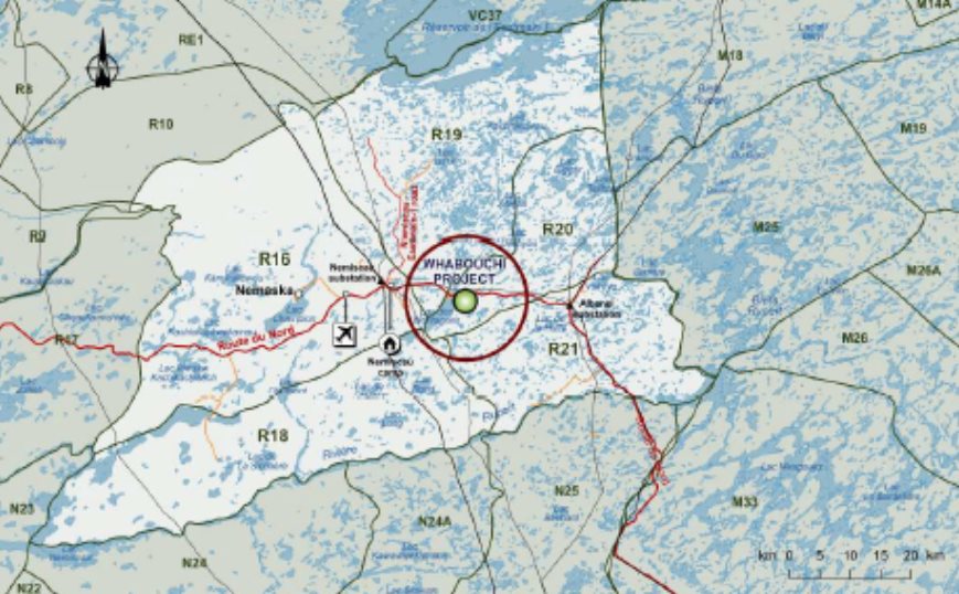
The mining Project is located in the administrative region of Nord-du-Québec within the territory of the municipality of James Bay in Quebec. The geographic coordinates are 75°51'49.7" West and 51°40'42.0" North (Figure 2).
2.2 Project Components
The components of the Project subject to this environmental assessment are illustrated in Figure 3 and include:
The mine:
- An open-pit with related surface infrastructure – The open-pit will be approximately 0.28 square kilometer and 150 meters deep;
- Underground operations – The construction of underground tunnels for the underground mining of the ore starting in year 21 for 6 years. The maximum ore processing rate will be slightly over 3 400 tons per day during the underground mining operations;
- Ore processing plant with related buildings – The ore will be crushed, milled and processed on site. The mine will supply the processing plant with approximately 3 000 tons of ore per day;
- Temporary ore stockpile – The temporary ore stockpile will have a capacity of approximately 20 450 tons and will cover an area of 0.0023 square kilometer;
- Waste rock and tailings pile – The waste rock and tailings pile will be constructed in two phases for a total area of 0.84 square kilometer. Phase 1 will reach a height of 60 meters and Phase 2 will reach 40 meters;
- Overburden storage area – The overburden storage area will have a capacity of 1.5 million cubic meters, approximately 0.41 million cubic meters of which will be re-used for the areas to be revegetated;
- Network of drainage collection ditches – The network of drainage water collection ditches will be equipped with five collection basins constructed at the main low points of the waste rock and tailings pile, with capacities of 6 800 cubic meters, 6 500 cubic meters, 6 600 cubic meters, 4 400 cubic meters, 8 400 cubic meters and 6 600 cubic meters;
- Holding pond and mine water collection pond – The holding pond, which will be filled with water from all collection basins, will be located southwest of the waste rock and tailings pile and will have a capacity of 30 000 cubic meters. The mine water collection pond, which will be the final pond, will be located southwest of the pit and will have a capacity of 26 000 cubic meters.
Figure 2: Location of the Whabouchi Mining Project

Source: Environmental and Social Impact Statement, Nemaska Lithium, March 2013
Figure 3: Key Project Components

Source: Answers to questions and comments by the Agency, Nemaska Lithium, December 2014
Related facilities:
- Support infrastructure (administrative and technical offices, maintenance garage and parts storage facility, water pumping station for fires, etc.);
- Drinking water intakes and two domestic water treatment systems;
- Service roads;
- A fuel storage area with a capacity of 100 000 liters;
- Three explosives storage areas.
To house workers, the Proponent plans to use a camp managed by the Cree Construction and Development Company located 12 kilometers from the mine site. Given that this camp is an existing structure, it is not considered part of the related Project facilities whose effects must be assessed as part of this environmental assessment.
The Proponent also plans to construct a lithium hydroxide and lithium carbonate production plant in Salaberry-de-Valleyfield in southern Quebec to process the spodumene mineral from the Whabouchi mine. However, this related activity (plant) is not included in the scope of this federal environmental assessment because it is a separate Project located in an industrial sector for which no adverse environmental effects are anticipated on components within federal jurisdiction. In addition, the construction of the plant is governed by provincial environmental regulations. Ore transport on the existing roads and rail line is not included in the scope as they have previously been assessed.
2.3 Project Activities
The Proponent is anticipating a construction phase of 19 months and an open-pit mine operation phase of approximately 20 years, followed by underground operations from years 21 to 26 (Table 2). The waste rock and tailings pile will be gradually rehabilitated starting in the 7th year of operations; two years are planned for mine closure and final site reclamation starting in 2043. A follow-up program will then be put in place for a minimum duration of five years in order to validate the effectiveness of the post-closure remediation measures. The estimated post-closure mine pit water filling period is approximately 43 years.
|
Preliminary work and construction phase |
Mine operations phase |
Mine closure phase (decommissioning and reclamation) |
Post-closure |
|---|---|---|---|
|
19 months |
26 years |
2 years* |
5 years or more |
|
* Rehabilitation of the waste rock and tailings pile starting in the 7th year of operation |
|||
|
|
|
|
3 Purpose of Project and Alternative Means
The following sections describe the purpose of the Project and a description and analysis of the main alternatives considered by the Proponent, including the justification of the Proponent's preferred option based on environmental, social, technical and economic criteria. Lastly, the Agency concludes on the choice and analysis of the alternatives conducted by the Proponent.
3.1 Purpose of Project
The mine would produce approximately 3 000 tons of spodumene ore per day over a period of 26 years. According to the Proponent, this spodumene deposit is the largest in North America and the second largest in the world. The demand for lithium on the world market is rising, due primarily to its use in the manufacture of batteries for electric vehicles and electronics (tablets, telephones, laptops, etc.).
3.2 Alternative Means of Carrying Out the Project
The Proponent assessed alternatives for the main components or activities of the Whabouchi Project. The relevant alternatives for the needs of this environmental assessment are summarized below. Annex D presents details of the assessment of the alternatives on the basis of technical, environmental, economic and social criteria.
3.2.1 Technology alternatives
Ore extraction
The Proponent considered two options: underground extraction alone or open-pit surface extraction followed by underground extraction. The Proponent's analysis shows that the option of underground extraction alone would have a less significant environmental effect, but is not economically viable due to the considerable losses of ore at the surface and at depth that would have to be left in place in order to maintain the structure of the underground tunnels. The selected option is open-pit surface mining followed by underground mining for the last six years for technical, economic and environmental reasons. Starting at a certain depth, it would become more technically difficult and more costly to continue the open-pit operations. The pit would have to be widened for the construction of the access roads at the far end of the mine, taking into account the gradeability of the trucks. The underground extraction of the ore located at depth would reduce both the amount of rock waste to be managed at the surface and the ultimate footprint of the pit compared to open-pit extraction for the same ore at depth.
Waste rock storage
The Proponent examined two options: returning the waste rock to the pit or storing it in a permanent waste rock pile. The first option would require temporarily storing the waste rock in a pile during the operation of the mine and then returning it to the pit, which would be flooded at the time of Project closure. This option may be advantageous in the case of acid-generating waste rock, because the anoxic conditions produced by flooding would slow down the oxidation mechanisms that cause water contamination by acid mine drainage. In this case, the waste rock is deemed by the Proponent to be non-acid-generating and non-leachable. As a result, considering the fact that once the waste rock is broken into pieces, not all of it can be returned to the pit and that the presence of a permanent pile would still be required, returning the material to the pit has no environmental or technical advantages. In addition, the costs associated with returning the material to the pit would be very high and would make the Project economically non-viable. The option of the permanent waste rock pile, without returning the waste rock to the pit, would allow for gradual restoration of the site and is economically viable.
Tailings pile (co-disposal with waste rock)
Two options were considered for tailings disposal: slurry tailings impoundment and filtered tailings storage. The latter option was selected on the basis of environmental criteria, including a reduced volume of tailings, recirculation of water to the processing plant, reduced risk of effects on water quality and the possibility of co-disposal with waste rock. Although the co-disposal of waste rock and tailings in the same pile is the most costly option, it was selected due to its environmental advantages.
Power supply
Three power supply options were considered for providing approximately 7.5 megawatts of electricity per year: the use of five 2 megawatts diesel generators, the construction of a, 25-kilovolt power line (20 kilometers in length), and a combination of the two options. According to the Proponent, supplying power to the site using diesel generators alone would have much more significant adverse environmental effects. However, powering the equipment in the pit with electricity would be more technically complex. The selected option, namely a combination of the two energy sources, would make it possible to reduce the adverse effects associated with the use of diesel generators while meeting the technical requirements of the mine operations.
Waste disposal
Three management approaches were evaluated by the Proponent: on-site management, use of the landfill of the community of Nemaska and use of the secure landfill of the municipality of Chibougamau. On-site management would require a new secure landfill, which would increase the Project's footprint, the potential environmental and social impacts, and the Project costs. The use of the secure landfill of the municipality of Chibougamau, located 300 kilometers from the mine site, would have adverse environmental and social impacts associated with greenhouse gas emissions, increased traffic, and higher operating costs. The selected option is the use of the landfill of the community of Nemaska, which is roughly 20 kilometers from the mine site. This option would have fewer adverse environmental effects (fewer greenhouse emissions, smaller footprint given that there is no requirement for the construction of a new landfill) and would be less costly (lower gasoline consumption, no new infrastructure to be built).
Water supply
Two water supply options were technically feasible: a surface water supply and a groundwater supply. Using surface water as the source of water supply would consist in pumping water from Lac du Spodumène. This option would involve the installation of an underground water pipe and the construction of an access road between the lake and the ore processing plant. For economic (construction and maintenance costs), technical (complexity of construction, risk of accidents) and environmental reasons (disturbance of soil and vegetation, disturbance of fish), this option was rejected. The Proponent opted for the installation of a well near the processing plant. The fresh water requirements of the process would be significantly reduced using the option of producing filtered, unsaturated tailings, which would allow for maximum reuse of the water.
Housing of workers
The Proponent assessed the options of housing the workers on site or using the "Le Relais routier" site, which is owned by the Cree. On-site housing would involve the construction of additional buildings and related infrastructure, thereby increasing the Project's footprint. The use of an existing camp would contribute to the local economy. The option of using existing infrastructure was selected on the basis of economic and environmental factors.
Location of the piles and final effluent
In the preliminary economic study, three options were considered (see Figure 4). The option selected at that time –option 1– allowed for the protection of a significant wetland and the continuation of activities within the territory, and it did not affect the existing power line. In response to concerns raised by the Cree Nation of Nemaska during consultations, the Proponent considered a new option –option 4– (see Figure 5), whereby the overburden, tailings and waste rock piles would be located further away from Lac des Montagnes and sensitive sectors, such as the Bible Camp, while maintaining the same advantages as option 1.
Option 4 is now the Proponent's preferred option. It would also eliminate any encroachment on Stream F, avoid wetland losses associated with the location of the overburden pile, move the explosives storage away from the settling pond dikes, avoid any realignment of Route du Nord, and reduce the Project's overall footprint.
The relocation of the various facilities outline in option 4 involves a change to the water management approach which supports the construction of a single final discharge point for the mine site. The final effluent would be discharged to Lac des Montagnes through a 1.4 kilometers underwater pipe. By comparison, the option previously selected by the Proponent in the preliminary economic study called for two discharge points, one into Stream C for water from the waste rock and tailings pile and a second into Lac des Montagnes for water from the pit and mine complex.
Figure 4: Location of options 1,2 and 3 proposed by the Proponent for the location of the waste rock and tailings pile

Source: Environmental and Social Impact Statement, Nemaska Lithium, March 2013
Figure 5: Comparison between the location of all mine facilities under option 1 (shaded areas) and that provided for in option 4 (green areas). Option 4 is the one chosen by the Proponent.

Source: Answers to questions and comments by the Agency, Nemaska Lithium, April 2014.
3.2.2 Comments received
Government authorities
Environment Canada is of the view that the environmental effects assessment provided by the Proponent is valid and finds that it is reasonable to believe that only small quantities of water and mud would reach the Lac des Montagnes. However, no modelling of assess the dike breach risks in support of the assumption that no major impact to the environment would result from such a breach. Also, no mitigation or contingency measures to reduce the risks of environmental contamination (soils, surface waters, etc.) following a dike breach were proposed by the Proponent. The Proponent is of the view that the effects of a breach in the settling pond dike would be very limited. The dike would contain a volume of only 26 000 cubic meters; its design would surpass the Quebec government's safety requirements, and a program to monitor the integrity of the settling pond dike would be put in place. In addition, the dike would be located approximately 1 kilometer from the Lac des Montagnes, the ground between the settling pond and the lake is gently sloped (between 1 % and 6 %), and the vegetation between the pond and the lake could filter the suspended solids carried with the water discharged after a dike breach.
Aboriginal communities
The Cree Nation of Nemaska voiced its concerns regarding the location of the settling ponds and waste rock and tailings pile proposed by the Proponent in option 1. The Cree were concerned about the possible effect of an accidental spill from the ponds into Lac des Montagnes and of the aesthetics and noise effects of the waste rock and tailings pile on Cree camps located in the vicinity of the Nemiscau River and Bible Camp. The Proponent took these concerns into account and proposed an option that would move the infrastructure further away from the sensitive areas (option 4).
3.3 Conclusion of the Agency on the selected alternatives
The Agency is satisfied with the alternatives analysis conducted by the Proponent for the purposes of the environmental assessment. Taking into account the technical and economic criteria for this type of Project, the Proponent took the concerns raised by the Cree Nation of Nemaska into consideration in its choice of alternatives having the least environmental effects for the Project.
4 Consultation Activities and Advice Received
Public and Aboriginal consultations strengthen the quality and credibility of environmental assessments. The comments and concerns received during the consultations contribute to identifying the potential effects of a project, as early as its planning stage. The Agency, in collaboration with the federal environmental assessment committee, conducted a number of public and Aboriginal consultation activities for the Whabouchi Mining Project.
4.1 Public Participation
The CEAA 2012 provides for three official opportunities for the public to participate in the screening, analysis of the environmental impact statement and preparation of the draft environmental assessment report. The Agency also held consultations on the draft guidelines for the preparation of an environmental impact statement by the Proponent.
4.1.1 Public participation led by the Agency
During the first public consultation on the preliminary screening, held from December 14, 2012, to January 3, 2013, the Agency received a comment from the public concerning the effect on the Project on the Little Brown myotis, a bat species designated as endangered under the Species at Risk Act. The second consultation was held from January 29 to February 28, 2013, seeking comments on the draft guidelines. No public comments were received by the Agency.
The third consultation was held from October 3 to November 2, 2013, seeking comments on the summary of the Proponent's environmental impact statement. At that consultation, the Agency received a brief prepared by the Société pour Vaincre la Pollution. It voiced a number of concerns regarding the effects of mine effluent, blasting and settling pond dike failures on water quality.
For the fourth consultation, the Agency invites the public to comment on the content, conclusions and recommendations set out in this draft environmental assessment report. After taking in consideration the comments received from the public, the Agency will finalize and submit the report to the Minister of the Environment. The Agency also invites the public to comment on the potential conditions set as part of the environmental assessment, which are outlined in a separate document available on the Canadian Environmental Assessment Registry's Internet site. They comprise the potential conditions the Agency is recommending to the Minister of the Environment should she determine that the Project is not likely to cause significant adverse environmental effects under Section 5.
Notices of these opportunities were posted on the Canadian Environmental Assessment Registry website, and individuals and groups who had expressed an interest in the Project during earlier phases were notified directly.
The Agency supported public participation in the environmental assessment through its Participant Funding Program. A total of 10 200$ was allocated to the Société pour Vaincre la Pollution to support its participation in the consultations on the environmental impact statement and draft environmental assessment report.
4.1.2 Public participation activities organized by the Proponent
In 2009, the Proponent presented his Project to the mayor and to the City Council of Chibougamau. According to the Proponent, the anticipated effects expected by the municipal authorities are of an economic nature and are perceived positively. An open house event was held in 2013.
4.2 Aboriginal Consultation
The federal government has a duty to consult and, where appropriate, to accommodate Aboriginal groups when it contemplates conduct that might adversely impact established or potential Aboriginal and treaty rights. Moreover, The CEAA 2012 requires that federal environmental assessments take into consideration changes to the environment that may affect Aboriginal peoples, such as:
- Health and socio-economic conditions;
- Physical and cultural heritage;
- Current use of lands and resources for traditional purposes;
- Any structures, sites or a thing that is are of historical, archaeological, paleontological or architectural significance.
The federal Government has a duty to consult Aboriginal groups, and, where appropriate, to accommodate, when its proposed conduct might adversely impact an established or potential Aboriginal or Treaty right. Aboriginal consultation is also undertaken more broadly as an important part of good governance, sound policy development and appropriate decision making.
For the purposes of the environmental assessment, the Agency served as Crown Consultation Coordinator to facilitate a whole-of-government approach to consultation. Aboriginal groups that were invited to participate in consultations included those identified as having an interest in the Project: the Cree Nation of Nemaska and the Cree Nation of Mistissini.
With respect to the Cree Nation of Mistissini, the Agency found that the Project was not likely to infringe on their rights, particularly because none of their traplines were likely to be affected by the Project. Although the Cree of Mistissini voiced concerns about increased traffic on the Route du Nord that could result from the Project, the Agency determined that this effect did not fall within the scope of the current federal environmental assessment since it had already been taken into account in the environmental assessment conducted for the construction of the road. For these reasons, the Agency did not hold separate consultations with the community of Mistissini. However, the Cree Nation of Mistissini contacted the Agency and asked to be kept informed of the conduct of the environmental assessment of the Project. The Agency sent the community the relevant documents for each public participation opportunity in keeping with this request.
The Agency and the Grand Council of the Crees agreed on an approach to allow participation of the Cree Nation in the federal environmental assessment process. Under this approach, a representative of the Cree Nation Government took part in the work of the federal environmental assessment committee and had an opportunity to participate in the development of the consultation plans for the Cree Nation, in the consultation activities, in the analysis of the environmental impact statement and the review of the draft environmental assessment report.
4.2.1 Aboriginal consultation led by the Agency
In order to fulfill the federal Government consultation obligations, the Agency conducted Aboriginal consultations in an integrated manner with the environmental assessment process.
The Agency provided the Cree Nation of Nemaska with a consultation plan that outlined consultation activities at the various phases of the environmental assessment.
The Cree Nation of Nemaska was invited to participate in the formal public consultations opportunities described in the previous subsection and had the opportunity to comment on this environmental assessment report. The Agency informed the band council of the Cree Nation of Nemaska through correspondence and notices on the Canadian Environmental Assessment Registry website and in local newspapers and radio stations.
A total of $35 828 from the Participant Funding Program was allocated to the Cree Nation of Nemaska to support their participation in the consultations related to the environmental assessment and the draft environmental assessment report.
For the first two consultations, the Cree Nation of Nemaska did not provide comments to the Agency on the summary of the Project description and draft guidelines. In the third consultation opportunity, the Cree Nation of Nemaska commented on the potential environmental effects of the Project, its potential impacts on treaty rights and the accuracy of the information provided by the Proponent in its environmental impact statement. The brief presented by the Cree Nation of Nemaska also contained proposals regarding the follow-up of the environmental effects. The Agency, in collaboration with the members of federal environmental assessment committee, held meetings with various stakeholders on November 19, 20 and 21, 2013, in the community of the Cree Nation of Nemaska. The Agency heard the concerns of the band council, the Jolly and Wapachee families, users of the territory of the Wapachee family, the Cree tallyman of trapline R20, a group of elders, a group of women and a group of young people from the community, particularly with respect to the anticipated effects on human health and the environment (see Annex E). These groups had asked to meet with the Agency. The potential effects on the Cree Nation of Nemaska are discussed in sections 7.4, 7.5 and 7.6.
This environmental assessment report was the subject of the fourth public consultation opportunity. The Agency met with the stakeholders on June 10 and 11, 2015 in the Cree Nation of Nemaska community. The Agency will present the comments received to the Minister of the Environment to inform her decision on the environmental assessment of this Project. The Agency also invited the Cree Nation of Nemaska to comment on the potential conditions set as part of this environmental assessment, which are outlined in a separate document available on the Canadian Environmental Assessment Registry website. They comprise the potential conditions the Agency intends to enforce if the Minister of the Environment decides that the implementation of the Project is authorized.
4.2.2 Aboriginal consultation and engagement activities organized by the Proponent
From the outset of the exploration work, the Proponent has held a number of meetings with representatives of the Cree Nation of Nemaska in order to discuss the Project.
The Proponent indicated that it held meetings in 2011 with the administrative staff of the Cree Nation of Nemaska, stakeholder groups and the band council in order to gain a better understanding of the social, economic and cultural context and to identify their concerns and expectations regarding the Project. The Proponent also indicated that it consulted with the users of the territory on approximately ten occasions to obtain a representative picture of the current use of the territory and of the anticipated effect of the Project on the territory. In September 2012, it held a public meeting open to the entire population. In addition, to facilitate dialogue with the Cree Nation of Nemaska, the Proponent opened a local office in Nemaska in 2012 and hired a Cree liaison officer responsible for gathering the community's concerns and communicating information related to the Project.
In 2012, the Proponent also set up a community advisory committee to establish a line of communication with a large number of stakeholders from Nemaska. The committee is composed of representatives of local organizations, the band council, the Cree trappers' association, hunters, young people, elders, and families whose hunting territory is most likely to be affected by the Project. Three meetings were held between February 2012 and June 2013.
4.3 Participation of Federal and Other Experts
Expert departments provided expert information or knowledge with respect to the Project in accordance with section 20 of the CEAA 2012. The following federal authorities provided advice in connection with the review of the Proponent's environmental impact statement and the preparation of this environmental assessment report: Fisheries and Oceans Canada, Environment Canada, Natural Resources Canada, Health Canada and Aboriginal Affairs and Northern Development Canada. A representative of the Cree Nation Government also joined the committee and participated in the review of the environmental impact statement by providing advice on the content of the report. The committee also contributed to the planning and conduct of the public and Aboriginal consultations throughout the federal environmental assessment process.
More specifically, Fisheries and Oceans Canada, which has regulatory and legal responsibilities under the Fisheries Act, provided comments and information on the potential adverse effects of the Project on fish and fish habitat and aquatic species at risk. As part of the environmental assessment for the Whabouchi Mining Project, Fisheries and Oceans Canada indicated that the Proponent would have to apply for autorizations under the Fisheries Act for the Project to proceed.
Environment Canada has regulatory and legal responsibilities under the Canadian Environmental Protection Act, 1999, the Migratory Birds Convention Act, 1994 and the Species at Risk Act, and is responsible for administering the pollution prevention provisions on fisheries including the Metal Mining Effluent Regulations. Environment Canada provided comments and information regarding the potential adverse effects of the Project on migratory birds and their habitat, species at risk, water quality, air quality, chemicals management, environmental emergencies and the application of the Metal Mining Effluent Regulations.
Natural Resources Canada has regulatory and legal responsibilities under the Explosives Act. It provided comments and information on the storage of explosives. It also provided specialist information in the areas of geology, hydrogeology and geochemistry.
Health Canada provided comments and information on the potential adverse effects of changes to air and water quality, noise environment and contamination of traditional resources on the health of Aboriginal communities.
The Cree National Government provided comments on the anticipated impacts on Cree nations.
5 Geographical Setting
5.1 Biophysical Environment
The Whabouchi Mining Project is located in the Canadian Shield, in the Superior Geological Province, which consists mainly of igneous and metamorphic rock. The deposit at the site of the Whabouchi Mining Project is of volcanic-sedimentary origin and consists of a spodumene-bearing pegmatite. The terrain elevation at the mine site ranges from 50 to 75 meters.
The climate of the region is subarctic cold continental, with mean daily temperatures of -20 degree Celsius in January and 17 degree Celsius in July. The mean annual precipitation recorded for the site is 77.2 centimeters of rain and snow.
The vegetation in the region is characterized by boreal forest composed of a mosaic of peat bogs and conifer and hardwood stands. Over half of the mine property is covered by recent burns or is in post-fire regeneration.
The mine site is located entirely within the Rupert River watershed, which covers an area of 43 400 square kilometers and drains towards Rupert Bay. Upstream of the mine site is the watershed of the Nemiscau River, a tributary of the Rupert River. Various lakes and streams are located in the vicinity of the Project site, the two largest of which are Lac des Montagnes and Lac du Spodumène. There are two aquifers at the mine site: a surficial aquifer and a regionally important fractured bedrock aquifer.
The Proponent recorded thirteen species of fish in the local study area, including Lake Whitefish, Pearl Dace, Walleye and Brook Trout. Four amphibian species were recorded in field surveys conducted in the summer of 2012.
According to the Proponent, hundred and thirty one bird species were observed or recorded at or near the Project site, including the Common Nighthawk, which is protected by the federal government under the Species at Risk Act.
Three species of large mammals are likely to be present in the study area, Moose, Caribou and Black Bear, ten species of small mammals were observed, including the Little Brown Myotis and Northern Myotis, which were recently designated endangered under the Species at Risk Act.
5.2 Human Environment
The Project is located 30 kilometers east of the Cree Nation of Nemaska and 280 kilometers north-northwest of the municipality of Chibougamau in the Nord-du-Québec administrative region, which is occupied by Jamesian, Cree and Inuit communities. In 2011, the Nord-du-Québec region had a total of 42 330 inhabitants, including 7 541 in the municipality of Chibougamau, 772 in the Cree Nation of Nemaska and 3 467 in the community of Mistissini.
The territory is governed by a number of organizational and administrative structures established under various acts and agreements, including the James Bay and Northern Quebec Agreement, which provides for the subdivision of the territory into Category I, II and III lands. The levels of exclusive hunting, fishing and trapping rights granted to the Cree are established on the basis of each category. The local study area is located on Category III lands, where the Cree have the exclusive right to harvest certain aquatic species and certain furbearing animals, but not to the exclusion of non-Aboriginal users, who may hunt and fish on the lands for recreational purposes.
The Grand Council of the Crees (Eeyou Istchee), together with the Cree Nation Government as administrative entity, represents the Cree and has the power and authority to promote, coordinate and administer programs designed to protect the traditional way of life, Cree culture and community development.
The Project site is located within the boundaries of trapline R20 (see Figure 6), in which trapping activities are focused on the area around the Lac des Montagnes and along the Nemiscau River. The trapline holders fish, trap furbearer in winter, hunt large game in fall, hunt goose in spring, and pick berries, wood and medicinal plants. Trapline R20 is characterized by hunting camps, snowmobile trails, valued sites, portage trails and navigable streams. The Bible Camp, a cultural camp that welcomes families from Nemaska during religious gatherings, traditional ceremonies and youth summer camps, is also located in the area.
Hunting camps used by the Cree are also found near the mine site along the Route du Nord, which runs through the mine site.
Close to 25 percent of all jobs in the Cree communities within the Nord-du-Québec administration region are directly tied to the primary sector (hydroelectricity, forests, and mineral resources). However, the community of Nemaska is an important administrative center for the territory of Eeyou Istchee, where 86 percent of all jobs are in health services, social and education services, and municipal or other government services sectors.
Figure 6: Location of the Traplines in the study area
Source: Environmental and Social Impact Statement, Nemaska Lithium, March 2013
6 Predicted Changes to the Environment
The Agency examined the changes that the Project is likely to cause to the environment, which are defined in the CEAA 2012. The environment includes components of the Earth, specifically, land, water and air, including all layers of the atmosphere, all organic and inorganic matter and living organisms, and the interacting natural systems that include components referred to above.
The predicted changes to the environment resulting from the Project that could result in a residual effect on the valued components outlined in Section 1.2.3 are associated with the atmospheric environment, groundwater and surface water, the noise environment and terrestrial environments (vegetation and wetlands).
6.1 Atmospheric Environment
This section examines air quality issues, particularly the dispersion of airborne particulate matter. The Agency considered the Project's effects on air quality given their potential impacts on fish and fish habitat and on the health of the Cree Nation of Nemaska.
The Project site is not located near a major population center or industrial activities. It is located near Route du Nord in an area with hunting, fishing and trapping camps used by the Cree Nation of Nemaska, as well as water bodies that serve as a source of drinking water. It is also located near the Bible Camp, a site that accommodates Nemaska Cree Nation families for religious gatherings and children for summer camps. The major existing atmospheric emission sources likely to affect air quality come from vehicles driven on Route du Nord. According to the Proponent, there do not appear to be any particular issues with air quality near the Whabouchi Project site at this time.
6.1.1 Proponent's assessment of environmental effects
Anticipated Effects
Air quality could be affected by suspended dust and gaseous contaminants generated by land clearing and site preparation, mining operations (ore extraction and processing), drilling, the use of generators and explosives, on-site traffic, and the transportation and storage of ore, waste rock and tailings. Poor maintenance and the idling of heavy machinery, vehicles and equipment could also generate gaseous compounds.
Atmospheric emission modelling was used to evaluate the potential effect of total and fine particulate matter emissions, gaseous compounds (sulfure dioxyde, nitrogen dioxyde, carbon monoxyde) and metal compounds (barium, beryllium, cadmium, chromium, cobalt, copper, lead, manganese, nickel and zinc) on air quality during the operation phase. The 23 receptors considered sensitive are the 22 Cree camps and the Bible Camp located near the mine site (see Figure 7). Years 7 and 16 were selected for modelling purposes since they are associated with the periods of most intense activity at the mine site. In year 7, the processing plant would be running at peak production, and the rate of ore and waste rock extraction from the pit would be higher than in any other year in the Project's life cycle. In year 16, although waste rock extraction from the pit would be lower than in year 7, the second waste rock and tailings cell would be brought in use, and the processing plant production rate would remain at a peak level. Emission sources considered in the modelling are those associated with the various mine operations, particularly vehicle traffic, truck loading and unloading, blasting in the pit, wind erosion and vehicle/heavy equipment emissions. In its modelling, the Proponent considered mining activities performed simultaneously or more frequently than it would actually be the case. This approach overestimates the frequency at which standards would be exceeded, but also provides a precautionary margin for the modelling results.
The modelling results show that all standards applicable to gaseous compounds and metal contaminants would be met beyond a 300-meters radius of the mine facilities for the duration of the Project. However, the modelling also predicted some exceedances of the ambient air standards set out in the provincial Clean Air Regulation in relation to total particulate matter and rare exceedances in relation to fine particulate matter. Exceedances would be less frequent in year 16 than in year 7, and would occur primarily in winter. Vertical dilution of contaminants tends to decrease in January, February and December, which could result in high concentration levels during these winter months. Such higher concentration levels would be present at a maximum distance of approximately 500 meters southeast of the mining area. The Proponent is of the view that, with the implementation of the proposed mitigation measures, there would not be any exceedances of the standards to occur for any contaminants (particulate matter, gas and metals) at the site of the 23 sensitive receptors considered for modelling purposes (i.e., the 22 Cree camps and the Bible Camp).
Figure 7: Specific air quality modelling receptors

Source: Atmospheric Emissions Dispersion Modelling, page 40, map 7.2, Nemaska Lithium, December 2014
Proposed Mitigation Measures, Monitoring and Follow-Up
The Proponent committed to implementing various mitigation measures to limit the adverse environmental effects on the atmospheric environment (Appendix A). These include measures designed to limit particulate matter emissions through a dust management program, including the appropriate use of dust-control agents, speed limits of 30 kilometers /hour on the Project site, and progressive restoration of the waste rock and tailings pile.
The Proponent committed to implementing a follow-up program for air quality around the mine facilities. The purpose of the follow-up program is to verify the results of the atmospheric emissions modelling and to monitor air quality near the mine site to allow for any necessary corrective action.
Anticipated Residual Effects
With the implementation of mitigation measures (Appendix A), the Proponent is of the view that the significance of the residual impact on air quality would be moderate. The intensity of the residual effect would be moderate due to a number of exceedances of air quality criteria that are anticipated near the mining zone. This effect would be local in extent, of moderate duration because the effect would be felt for the life of the Project, and would be completely reversible given that air emissions would cease at the end of the Project.
6.1.2 Views expressed
Federal authorities
With respect to the Project's effect on air quality, Health Canada is of the view that if the contaminant concentrations measured during mining operations are similar to the modelled concentrations, the Project should not cause adverse health effects to neighboring Aboriginal populations. Environment Canada believes that a 95 % reduction in dust levels through the implementation of the mitigation measures suggested by the Proponent is overly optimistic. The use of this reduction rate in the atmospheric dispersion modelling could underestimate the predicted air contaminant concentrations. Health Canada therefore considers it important to verify the accuracy of the modelling and the actual effectiveness of mitigation measures by means of the air quality monitoring program, especially at the location of sensitive receptors in the vicinity (e.g., hunting camps, Bible camp).
The Proponent did not submit an estimate of dust deposition in surrounding environments. In the absence of data, Environment Canada remains concerned about the potential effect of dust deposition (metals and non-metals) in the receiving environment, particularly in the aquatic environment, such as Lac du Spodumène, which is located in the path of prevailing winds. Dustfall could also combine with discharges of metals and suspended solids from the effluent. According to Health Canada, the assessment of the long-term health effects of dustfall on metal concentrations (or any other contaminants related to the Project) in soil, water and traditional food sources should have been more exhaustive.
The Proponent committed to implementing mitigation measures and a dust management program to mitigate dust emissions generated by the Project. It will also establish a follow-up program for air quality around the mine facilities to measure the effect of mining activities on air quality and to take any necessary corrective action to comply with the applicable standards. The Proponent also proposed follow-up of water quality in water bodies around the mine site, as discussed in Section 6.2 below.
Aboriginal Groups
The Cree Nation of Nemaska has expressed concerns about the possible toxicity of dust generated by the mining activities. These concerns are discussed in Section 7.5.
6.2 Groundwater and Surface Water
The Agency has considered the effects of the Project on the quantity of groundwater and surface water given their potential effects on fish and fish habitat, migratory birds and the health of the Cree Nation of Nemaska.
The mine site is located along two large lakes: Lac des Montagnes to the west, covering an area of 13 750 000 square meters, and Lac du Spodumène to the southeast, covering 610 000 square meters. The local study area also includes six low-flow streams and several small lakes (from 1 440 square meters to 64 000 square meters). Stream A flows into the Nemiscau River, and streams B, C, D, E and F flow into Lac des Montagnes (see Figure 8). Groundwater primarily recharges through the infiltration of surface water and discharges into surface streams that flow into the Nemiscau River, Lac des Montagnes and Lac du Spodumène.
The two sampling campaigns conducted by the Proponent show that baseline surface water quality in the local study area is acidic (pH between 4.7 and 7). Such pH levels do not meet the surface water criteria establish by the Quebec government or the Canadian Water Quality Guidelines for the Protection of Aquatic Life.[2] In the second sampling campaign (2014), exceedances of the criteria and guidelines have also been noted in the case of baseline dissolved oxygen, fluorides, C10-C50 petroleum hydrocarbons, mercury, aluminum, arsenic, beryllium, copper, iron, lead and zinc. The largest number of exceedances was observed in small lakes and streams near the site and involves pH, aluminum, mercury, lead, beryllium and dissolved oxygen. The Proponent's sampling also revealed levels exceeding the bacteriological standards of the Quebec Regulation Respecting the Quality of Drinking Water for total coliforms.
The characterizations conducted by the Proponent show that the groundwater in the local study area is contained in two aquifers, one in surface deposits and the other in rock. According to the Quebec government groundwater classification guide (MDDEFP, 1999), the quality of groundwater in surface deposits in Quebec is not suitable for consumption (Category III[3]). The Proponent claims that groundwater in the bedrock fracture system could be used as a drinking water source, but would probably require treatment to make it drinkable.
6.2.1 Proponent's assessment of environmental effects
Anticipated Effects
Water Quantity
The assessment of the Project's effects on surface and groundwater quantity targets the watersheds identified in Figure 8. Streams B, C, E and F and Lakes 2, 27 and 28 would be the most seriously affected by site preparation and mine development. Although there would be no encroachment on these lakes and streams, the development of the waste rock and tailings pile and the construction of buildings and ditch system around this infrastructure would reduce the area of their watersheds and thus, their inflows. Lake 29, which covers an area of 1.44 square kilometer, would be destroyed by the development of the waste rock and tailings pile; however, this lake has no surface hydrological connection to the other lakes or streams.
During the operation phase, water pumping for mine pit dewatering would cause significant groundwater drawdown, which could have effects on the hydrographic network and surrounding wetlands. Including the open pit, the total estimated area of the drawdown area would reach 4.06 square kilometers.
Stream C and Lake 2 would be affected by the combined effect of groundwater drawdown and watershed reduction resulting from the presence of the mine facilities.
Tables 3 and 4 present the current and anticipated water levels identified by the Proponent for the lakes and streams affected by the Project.
Figure 8: Location of Lake and Stream Watersheds

Source: Appendix 148.1, map 2.1, Nemaska Lithium, December 2014
|
Stream |
Average Depth (centimeter) |
Average Annual Flow (Liter/second) |
|||||
|---|---|---|---|---|---|---|---|
|
Initial |
Planned |
Loss (centimeter) |
Initial |
Planned |
Reduction % |
||
|
*The Proponent performed a monthly assessment of the anticipated drop in water levels and water flows in Stream C. Source: Adapted from the Proponent's responses to CEAA requests for clarification, Nemaska Lithium, December 2014 |
|||||||
|
Stream B |
5 |
4 |
1 |
4.4 |
2.9 |
33 |
|
|
Stream C* |
Upstream |
5 to 12 |
0 to 6 |
5 to 7 |
13.3 |
1.2 |
91 |
|
Central |
8 to 19 |
0 to 12 |
5 to 8 |
25.4 |
4.9 |
81 |
|
|
Downstream |
9 to 21 |
6 to 17 |
3 to 4 |
41.0 |
20.2 |
51 |
|
|
Stream E |
15 |
14 |
1 |
5.3 |
4.2 |
21 |
|
|
Stream F |
6 |
2 |
4 |
1.3 |
0.1 |
92 |
|
|
Parameters |
Lake |
|||||||||
|---|---|---|---|---|---|---|---|---|---|---|
|
Lake 2 |
Lake 3 |
Lake 27 |
Lake 28 |
Lake 30 |
||||||
|
Source: Adapted from the Proponent's responses to CEAA requests for clarification, Nemaska Lithium, December 2014 |
||||||||||
|
Lake Area (square meter) |
47,247 |
11,586 |
5,453 |
2,315 |
6,319 |
|||||
|
Water Volume (cubic meter) |
62,576 |
36,609 |
8,135 |
1,370 |
8,746 |
|||||
|
Average Depth (meter) |
1.4 |
2.9 |
1.4 |
0.6 |
1.4 |
|||||
|
Maximum Depth (meter) |
4.2 |
5.3 |
4.4 |
1.2 |
4.9 |
|||||
|
Initial |
Planned |
Initial |
Planned |
Initial |
Planned |
Initial |
Planned |
Initial |
Planned |
|
|
Watershed Area (square kilometer) |
0.70 |
0.23 |
0.43 |
0.37 |
0.15 |
0.05 |
0.07 |
0.01 |
0.05 |
0.03 |
|
Decrease in Watershed Area (%) |
67 |
13 |
67 |
83 |
36 |
|||||
|
Outgoing peak flow (cubic meter/second) |
0.669 |
0.202 |
0.444 |
0.384 |
1.198 |
0.076 |
0.085 |
0.039 |
0.088 |
0.066 |
|
Water level reduction (centimeter) |
14 |
2 |
7 |
16 |
3 |
|||||
Water Quality
Changes in surface and groundwater quality could result from sediment loading to lakes and streams, potential acid mine drainage, metal leaching or contamination by chemical or bacterial products.
During the construction phase, site preparation and development work could cause erosion, increase the quantity of suspended solids and thus alter water quality in the following sub-watersheds:
- Stream A: includes Lake 1;
- Stream B: includes Lakes 27 and 28 and Streams E and F;
- Stream C: includes Lake 2;
- Stream D: includes Lac du Spodumène and Lakes 3, 16, 30 and 31.
During the operation phase, water quality in Lac des Montagnes could be affected by the discharge of mine effluent, since the final discharge point for mine water from the retention basins would be located in the lake.
The Proponent states that according to the modelling study of the mine effluent dispersion plume in Lac des Montagnes, the anticipated low level of contaminants in the effluent and the presence of a mixing area at the discharge site would make it possible to comply with the receiving environment requirements, whether under the government of Quebec Directive 019 or the federal Metal Mining Effluent Regulations. The Proponent has committed with the Government of Quebec to install a water treatment unit at the outlet of the mine water retention basin for preventive purposes. This unit could be quickly brought online if water quality standards are not met.
Tests by the Proponent indicate a low potential for acid drainage from waste rock and tailings given that they contain, on average, 0.20 % to 0.14 % sulphides, respectively. The ore would have no potential to generate acid given that its sulphide content ranges from 0.04 % to 0.06 %, which is below the level specified in Quebec's Directive 019.[4] Ore leaching tests show levels below the Government of Quebec's acute toxicity criteria for protecting aquatic life, except for beryllium. According to the Proponent, the beryllium test result is very conservative because it magnifies field conditions. The Proponent therefore claims that the actual beryllium levels in the leachate of the temporary ore pile would be below the Quebec government acute toxicity criterion. The Proponent's tests also indicated a low probability of metal leaching (uranium, mercury, copper, aluminum and iron) in surface water and groundwater.
Furthermore, the application of dust control agents and de-icing salts on roads could contribute to a change in water quality. However, the Proponent stated that considering the limited use of de-icing salts and dilution and dispersion phenomena in water, a significant change in water quality caused by de-icing salts is unlikely.
The use of explosives for mining operations could lead to the presence of ammonia and nitrate in water bodies and streams near the mine site. However, the Proponent opted for an emulsion-type explosive,[5] which has very limited water solubility and contains 20.6 % less nitrogen than Ammoniac Nitrate Fuel Oil (ANFO),[6] which is generally used and more water soluble.
Domestic wastewater discharge could also lead to bacterial contamination of surface water. According to the Proponent, these effects would be avoided given that no effluent would be connected to the surface water network and septic tanks would be periodically emptied by an authorized company.
During the decommissioning phase, the dismantling of mine infrastructure (ditches, buildings and ponds) and shoreline work carried out on the littoral of Lac des Montagnes for the dismantling of the mine effluent conduit would occasionally result in increased turbidity and suspended solids concentrations in water.
Proposed Mitigation Measures
The Proponent has committed to implement various mitigation measures to reduce the adverse environmental effects on groundwater quality and on the quantity and quality of surface water (Appendix A), including:
- Fully recycle and recirculate process water;
- Provide a drainage system and a runoff management program for all contaminated water and mine contact waters and channel these waters to the mine water retention pound;
- Install a water treatment unit at the outlet of the mine water retention pound for preventive purposes;
- Minimize land clearing, especially along the shores of lakes and streams, and restore disturbed areas;
The Proponent committed to conduct the following monitoring in connection with water resources:
- Monitoring of groundwater quality and levels during construction, operation and post-closure periods in accordance with the requirements of Quebec government's Directive 019. Monitoring will include the creation of observation wells and piezometric monitoring upstream and downstream of facilities considered at risk. If criteria are exceeded or if readings are abnormal, the necessary corrective measures will be implemented;
- Monitoring of the final effluent discharge to Lac des Montagnes in accordance with the requirements of the federal Metal Mining Effluent Regulations and Quebec government's Directive 019. Monitoring will detect changes in water quality and allow for appropriate corrective action as necessary;
- Given the proximity of the infrastructure, monitoring of surface water quality for aquatic life, covering the major lakes and streams potentially affected by the Project, i.e., Lakes 2, 27 and 28 and Streams C and F, and at control stations located in lakes upstream from the Project or in a watershed unaffected by it, such as Lake 18.
Anticipated Residual Effects
Water Quantity
With the implementation of the mitigation measures (Appendix A), the Proponent is of the view that the significance of the residual effect on water quantity would be low to moderate. The surface hydraulic dynamic would only change slightly over the mine site area as a whole, but the impact of groundwater drawdown could affect several water bodies and streams in the sub-watersheds of streams A, B, C and D. Changes to the hydraulic system would be noticeable outside the Project area and the impact would be long-lasting considering that it would persist after the decommissioning phase. The Proponent is committed to provide compensation for the loss of Lake 29 through the wetlands and water bodies compensation programs provided for under the Quebec government Act Respecting Compensation Measures for the Carrying Out of Projects Affecting Wetlands or Bodies of Water (2012, c. 14).
Water Quality
With the implementation of mitigation measures (Appendix A), the Proponent is of the view that the significance of the residual effect on water quality would be moderate due primarily to the amount of suspended solids in surface water. It is also of the view that the extent of the effect would be local, and the duration moderate since it would be felt for the life of the Project and water quality will return to its original condition once the Project ends.
6.2.2 Views expressed
Federal authorities
In response to requests from Natural Resources Canada and Fisheries and Oceans Canada, the Proponent provided additional information on the groundwater drawdown modelling used to assess the anticipated flow and levels of lakes and streams. Based on this information concerning the hydrologic connection between surface water and groundwater and the modelling of the Project's effects on the reduction of surface water inflows, Fisheries and Oceans Canada was able to assess the potential effects on fish habitat resulting from changes in the water balance of the sub-watersheds included in the area likely to be affected by the Project, as shown in Section 7.1. The Proponent has committed to monitor surface water flows and levels in certain lakes and streams (see Section 7.1).
Environment Canada issued an advisory about the risk of overflows of the mine water retention ponds from heavy flooding throughout the Project's life cycle. The Proponent has increased the capacity of these ponds to ensure they can accommodate floods that occurs every 100 years.
According to Environment Canada and Natural Resources Canada, there remains some uncertainty regarding the characterization of the various excavated materials (sample representativeness) and the results of leaching tests. Furthermore, Government of Quebec water quality criteria were not met for three metals during leaching tests: aluminum, copper and beryllium. Environment Canada is of the view that the Proponent should pursue the material characterization program during the operation phase to identify any new leachable substance that might enter the water and take the results into account when developing its follow-up program. It should also establish groundwater protection measures if required. Environment Canada and Natural Resources Canada more specifically recommended that the results of the in situ kinetic test using the "barrel" procedure be used to confirm the relevance of installing a membrane beneath the waste rock and tailings piles.
A discharge limit was set for copper under the Metal Mining Effluent Regulations, and aluminum is one of the substances to be monitored through Environmental Effects Monitoring studies as prescribed by the same Regulations. Despite information submitted by the Proponent to support the non-toxicity of lithium, Environment Canada remains concerned about the possible discharge of lithium into the aquatic environment. Lithium is listed on the Domestic Substances List of the Canadian Environmental Protection Act, 1999, and is therefore considered to have intrinsic properties that are toxic to the environment, particularly to aquatic organisms. Environment Canada indicated that there was still a risk of contamination from lithium and beryllium - two substances that are not covered in the Metal Mining Effluent Regulations. Environment Canada recommends that these substances also be included in the monitoring of the effluent monitoring before its discharge to the environment, in accordance with the same requirements as for the other parameters listed in Schedule 2 of the Regulations.
In addition to complying with the requirements of government of Quebec's Directive 019 and the Metal Mining Effluent Regulations, the Proponent is committed to monitor the following substances at the effluent outlet and in the receiving environment, i.e., Lac des Montagnes: beryllium, lithium, cesium, rubidium, chromium, potassium, sodium, magnesium, manganese, petroleum hydrocarbons (C10-C50). The Proponent has also committed to install a water treatment unit at the mine water pond outlet and to put it into operation, as necessary, to quickly respond to any exceedances detected.
Aboriginal Groups
Members of the Cree Nation of Nemaska are concerned about possible human health problems that could result from eating fish or waterfowl that could be contaminated by the water. The Proponent's responses are presented in Section 7.1.
Public
The Société pour vaincre la Pollution (SVP) voiced concerns about potential water contamination at the mine effluent discharge site, resulting either from leaching of ore or the use of ammonium nitrate-based explosives, and requested an independent validation of the Proponent's models. Natural Resources Canada reviewed the acid rock drainage and metal leaching potential studies and results provided by the Proponent, and requested additional results from in situ barrel tests to confirm the low potential for metal leaching from the Project. Natural Resources Canada was satisfied with the studies and results presented by the Proponent that indicated low potential for acid rock drainage from the Project. The water quality modelling results were found to be acceptable by Environment Canada.
Société pour Vaincre la Pollution questions the application of the Metal Mining Effluent Regulations to the Whabouchi mine, stating that the mine is a rare earth mine and indicating that it is concerned about the possible discharge of uranium to water. Environment Canada considers that the Metal Mining Effluent Regulations apply to this mine since it will produce a concentrated metal, and specified that all harmful substances listed in Schedule 4 of the Metal Mining Effluent Regulations are covered by the general prohibition in subsection 36(3) of the Fisheries Act, which prohibits the deposit of harmful substances into water frequented by fish.
6.3 Sound Environment
The effects of the Project on the sound environment were considered by the Agency due to their potential effects on use of the territory and the heritage of the Cree Nation of Nemaska, on migratory birds and on species at risk.
The existing noise at the Project site is attributable to natural noise (wind, wildlife, etc.) and human noise (vehicle traffic on Route du Nord and aircraft at the Nemiscau airport). The existing noise levels recorded at the Project site were 43.5 decibels (A) during the day and 36.4 decibels (A) during the night, which corresponds to a relatively quiet environment. Sound levels authorized in the Note d'instructions 98-01 sur le bruit published by the government of Quebec, June 2006 correspond to 55 decibels (A) during daytime and 50 decibels (A) for nighttime.
6.3.1 Proponent's assessment of environmental effects
Anticipated Effects
The Cree camps closest to the mine site are located at approximately 1 to 2 kilometers from the waste rock and tailings pile and the Bible Camp is located at approximately 3 kilometers (see Figure 9). Modelling of the Project's effects on sound levels made it possible to assess the potential effects during all phases of the Project on the 23 sensitive receptors. The Category III zoning established under the government of Quebec Note d'instructions 98-01 was used to determine the noise limits applicable to the 23 receptors. This zoning category corresponds to an area intended for commercial use or recreational parks with daytime noise limits of 55 decibels (A) and nighttime limits of 50 decibels (A). In terms of the noise generated by blasting activities, the limit is 128 linear decibels.
The sources of Project effects on the sound environment include the use of equipment and heavy machinery, drilling and blasting, the dismantling of mine site infrastructure, as well as vehicle traffic at different phases of the Project.
According to the modelling results, the anticipated noise levels would be lower than the government of Quebec authorized limits and would not lead to a significant increase in percent highly annoyed by the noise (one of the indicators used by Health Canada for noise assessments).
Figure 9: Location of Cree Camps and Bible Camp

Source: Nemaska Lithium, December 2014
Proposed Mitigation Measures, Monitoring and Follow-Up
Changes in the location of the waste rock and tailings pile made it possible to move one major source of noise generated by the Project farther away from sensitive receptors.
Although the Proponent does not anticipate any major significant effects resulting from the Project on sound perceived at the various sensitive receptor locations, it plans to implement certain complementary mitigation measures, including an equipment maintenance plan and execution of the noisiest activities during the day.
The Proponent proposed to implement an acoustic monitoring program during the construction and operation phases to ensure compliance with noise levels, to verify mitigation measures and to make any necessary corrections. The Proponent also committed to conduct a survey on questions related to community wellness.
Anticipated Residual Effects
With the implementation of mitigation measures, the Proponent is of the view that the residual effect would be moderate. Considering that the noise levels would meet the limits authorized by the Government of Quebec at all times and would not exceed the anticipated results of the noise assessment conducted, the Proponent believes that the magnitude of the effect would be low and the extent localize. The duration of the effect would be moderate given that the noise environment would return to what it was prior to the Project.
6.3.2 Views expressed
Federal authorities
Given the noise-related concerns of area users, the Agency asked the Proponent to re-evaluate the significance of the Project's effects on the sound environment and to suggest mitigation measures. In response to this request, the Proponent updated the noise modelling following changes in the location of mine infrastructure. The results confirm no significant effect on the sound environment. Health Canada believes that if noise levels measured in the field during mine operations are similar to the modelled levels, the Project should not have harmful effects on the health of the Cree Nation of Nemaska. According to Health Canada, it is very important to verify the modelling results and the effectiveness of mitigation measures in order to validate the findings of the noise impact study and to implement additional mitigation measures if necessary.
Environment Canada considers that the noise generated by mining activities during all phases of the Project may be a source of disturbance to migratory birds, including species at risk. This issue is discussed in more detail in Section 7.2.
Aboriginal Groups
The Cree Nation of Nemaska is concerned that blasting noise could bother users of the Bible Camp, a calm and peaceful site enjoyed by the community. It is also concerned that wildlife will be disturbed by the noise and will leave the Project area. Section 7.6 contains responses to these concerns.
6.4 Terrestrial Environments and Wetlands
The Project's effects on terrestrial environment and wetlands have been considered by the Agency given their potential effects on use of the land and on the physical and cultural heritage of the Cree Nation of Nemaska, and on migratory birds and species at risk.
Terrestrial environments include forest stands (conifers and deciduous), recent burns caused by forest fires in 2002 and areas previously disturbed by land clearing during the exploration phase and by temporary storage for construction materials, among others. Wetlands include bogs and fens, as well as shoreline shrub swamps. The Lac du Spodumène bog is located to the south of the pit. Figure 10 shows that the Project site is located in an area covered largely by recent burns. The study area contains no unique or significant forest ecosystems or protected areas.
Terrestrial and wetland environments are suitable habitats for mammals and birds. Several small (furbearing animals, micromammals and bats) and large (caribou, moose and black bear) wildlife species use the terrestrial and wetland habitats present in the study area. Burns, disturbed environments and bogs provide suitable habitat for several bird species designated under the Species at Risk Act (see Section 7.3). Wetlands are likely used by birds for feeding, nesting, breeding, rearing and resting.
Figure 10: Characterization of the Terrestrial Environment of the Whabouchi Project
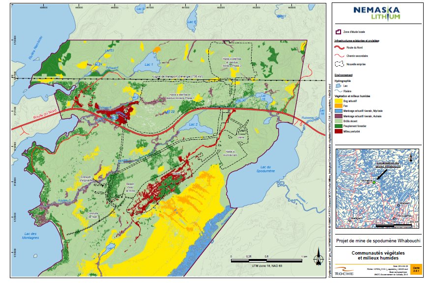
Source: Nemaska Lithium, April 2014
6.4.1 Proponent's assessment of environmental effects
Anticipated Effects
The Proponent believes that activities involved in site preparation (clearing and grading), pit excavation, construction and dismantling of mine site infrastructure, the management of surface deposits, development of the waste rock and tailings pile and water pumping would result in the loss of terrestrial and wetland environments. As discussed in Section 6.2.1, pumping would cause a significant drawdown of groundwater, which could affect the Lac du Spodumène bog. In the summer of 2015, the Proponent will update the geotechnical study to identify the nature of the substrate and hydraulic connections between the bog and the aquifer in order to determine the effect of the drawdown.
Overall, the Project would cause the temporary loss of approximately 1.55 square kilometer of habitat, including 1.25 square kilometer of recent burns (see Figure 11). After restoration of the mine site, the permanent loss of 0.28 square kilometer of vegetation would result from the presence of the flooded pit and presence of the stockpiles (mining waste, tailings and overburden), which would destroy 0.074 square kilometer of wetlands (including Lake 29 and its marsh).
Figure 11: Area (square kilometer) of Terrestrial and Wetland Environment Affected by the Whabouchi Project

Source: Adapted from Figure 7-1, page 7-6 of the Environmental and Social Impact Assessment, Nemaska Lithium, March 2013
Habitat losses related to site preparation and development range from 0.16 square kilometer and 1.55 square kilometer for furbearing animals, micromammals, bats and small and large mammals (see Table 5).
For nesting birds, 1.55 square kilometer of habitat would be lost. Of these, the Proponent has determined that the destruction of Lake 29 to develop the waste rock and tailings pile would affect one waterfowl breeding pair. For other aquatic birds, 1 to 3 breeding pairs could be affected by the loss of wetlands. The loss of terrestrial habitat would affect 471 forest bird pairs. However, according to the Proponent, for some species such as grouses, quails, raven and peckers, the lost habitats would be negligible because these species would be able to relocate to similar environment adjacent to the mining area or elsewhere in the study area. Habitat losses that could impact birds are presented in Table 5.
According to the Proponent, changes to habitats caused by mine infrastructure could benefit certain species. The adverse effects caused by the loss of breeding habitat during the construction phase could be partly offset by a temporary gain in anthropized habitat (stripped sites, roadsides and piles) for Killdeer, Spotted Sandpiper, Belted Kingfisher, Tree Swallow, Common Nighthawk and Common Raven. This gain would be temporary since the mine site would be re-vegetated upon Project closure.
The change in terrestrial and wetland environments caused by the waste rock and tailings pile could alter landscape elements such as views from the Bible Camp and hunting camps.
|
Mammal |
Area affected (square kilometers) |
|---|---|
|
*Furbearing animals (beaver, mink, fox, etc.), micromammals (voles, mice, shrews, etc.) and bats |
|
|
Small wildlife* |
1.55 |
|
Migrating Caribou |
1.41 |
|
Woodland Caribou |
0.16 |
|
Moose |
1.44 |
|
Black Bear |
1.55 |
|
Birds |
|
|
Waterfowl |
0.0016 |
|
Waterbirds |
0.075 |
|
Landbirds |
1.48 |
|
Olive-Sided Flycatcher |
1.27 |
|
Common Nighthawk |
1.43 |
|
Short-Eared Owl |
0.004 |
|
Rusty Blackbird |
0.07 |
Proposed Mitigation and Follow-Up Measures
The Proponent committed to implement a number of mitigation measures to limit the adverse environmental effects on terrestrial environment and wetlands (Appendix A), including:
- Establish a committee composed of the Project's key stakeholders to develop a wetland loss compensation plan;
- Clearly identify and delineate work areas to minimize the size of terrestrial and wetland environments affected;
- Keep clearing to a minimum and restore disturbed areas;
- Carry out progressive re-vegetation of the waste rock and tailings pile (as operating conditions allow).
The Proponent committed to perform the monitoring specified below as it relates to terrestrial habitat loss:
- Monitor the effectiveness of re-vegetation of disturbed sites following progressive restoration and mine closure. Reseeding work will be performed in areas of insufficient regrowth;
- Monitor changes in the hydrological, ecological and habitat functions of the Lac du Spodumène bog and adjacent shrub marsh to determine the actual effect of mine pit dewatering. If required, compensation measures based on results of the monitoring program will be submitted to the Quebec government.
Anticipated Residual Effects
With the implementation of mitigation measures (Appendix A), the Proponent is of the view that the significance of the residual effect of the Project on the terrestrial environment (forest stands, burns and stressed environments) is moderate. The magnitude of the residual effect would be moderate given that the effect would occur only once, during the construction of mine infrastructure, and that most of the area covered by land vegetation at the mine site would be affected temporarily or permanently. The extent of the effect would be local since the effect would be limited to the mine site, primarily the site of the mine infrastructure and facilities. The duration of the effect would be long-lasting since the land vegetation in the pit area would be lost. The effect would be irreversible, considering that the land vegetation at the mine site would be destroyed, although the loss would be offset by the restoration work planned during the decommissioning phase.
The Proponent is of the view that the significance of the residual effect on wetlands would be low, primarily because the extent of the effect would be site-specific since it would affect a limited area of the mine site, and partial compensation for the wetlands would be undertaken under the government of Quebec Act Respecting Compensation Measures for the Carrying Out of Projects Affecting Wetlands or Bodies of Water (2012, chapter 14). The duration of the effect would be long-lasting since wetlands restoration would require several years. The effect is partly irreversible given that wetland environments would be destroyed to carry out the Project and would not be restored.
Given the abundance and common nature of the terrestrial and wetland environments regionally, the Proponent concluded that the anticipated losses in these environments would have no significant effect either locally or regionally.
Furthermore, the Proponent committed to compensate for wetland losses in order to meet the requirements of Quebec regulations. A committee would be created by the Proponent to develop a compensation program. If a decision is made to proceed with wetland development, the relevant activities will be subject to a monitoring starting at the construction phase. The monitoring program would be established within the framework of the application of the Quebec Environment Quality Act.
6.4.2 Views expressed
Federal authorities
To better assess the Project's effects on migratory bird species and species at risk, Environment Canada asked the Proponent to provide further details on anticipated wetland losses, particularly in terms of habitat function losses. The Proponent provided additional information discussed in Sections 7.2 and 7.3.
Natural Resources Canada believes that the explanation of the methodology used to estimate water exchanges between streams and groundwater provided by the Proponent is incomplete and does not permit a satisfactory conclusion to be drawn as to the effects of pit pumping on the Lac du Spodumène bog. According to Natural Resources Canada, the Proponent did not sufficiently document the hydrologic connection between the Lac du Spodumène bog and the underlying aquifer. However, the Proponent did characterize this bog in the field as being of the ombrotrophic type. This type of bog is fed only by precipitation, and in theory, would be unaffected by any change in the hydrogeology under the bog. According to the Proponent, exchanges between the local aquifer and groundwater in the bog could be limited or non-existent. The Proponent committed to gather additional data on the nature of the substrate underlying the bog and on the local hydrology during the geotechnical study update planned in the summer of 2015 to further clarify the potential impact of groundwater drawdown on the bog and on other biological components, such as plants and wildlife (including migratory birds).
Aboriginal groups
Many members of the Nemaska community have expressed concerns that use of the Bible Camp will be disturbed by the visual impact caused by the presence of mine infrastructure in the terrestrial environment. See Section 7.6.2 for the Proponent's response to this question.
7 Predicted Effects on Valued Components
Approach
The Agency assessed whether the anticipated changes to the environment from the Whabouchi Project could affect the valued components selected in Section 1.2.3 and whether the Proponent's proposed mitigation measures would reduce these effects.
The suite of mitigation measures proposed by the Proponent is found in Appendix A. Where necessary, the Agency identified mitigation measures it considers essential in order to conclude that the effects on valued components are not significant. The development of potential conditions is based on these key mitigation measures, which are recommended to the Minister by the Agency. Appendix F presents a summary of the anticipated residual effects for each federal valued component, as well as the Agency's determination of significance of those effects after taking into consideration the implementation of mitigation measures.
7.1 Fish and Fish Habitat
7.1.1 Proponent's assessment of environmental effects
According to information obtained by the Proponent from the Commission régionale sur les ressources naturelles et le territoire de la Baie?James, 33 species of freshwater fish are found in the James Bay hydro-geographic region. The Proponent carried out fish stock surveys in the mine area in 2010, 2011 and 2012, and only 13 fish species were captured. Among them, brook trout, northern pike, yellow perch, walleye, burbot and lake whitefish are considered sport fish, and white sucker and longnose sucker are valued species in traditional Cree culture.
Figure 8: shows the major water bodies and watercourses in the study area. Among them, the largest lakes comprising fish habitat are Lac des Montagnes, in which white sucker, longnose sucker, northern pike, lake whitefish and walleye are found, and Lac du Spodumène, in which northern pike, lake whitefish, yellow perch and walleye are found. Several small water bodies also support fish populations, particularly Lake 2, which contains brook trout, and Lake 3, which contains northern pike.
The watercourses that containing fish habitat in the study area are for the most part small streams, namely streams A, B, C, D, E and F (see Figure 8). Few fish were captured during surveys in streams, except Stream C, the outlet of Lake 2 in which brook trout occurs. The other streams support burbot, northern pike and brook stickleback populations. The only river in the Project area is the Nemiscau River, which supports primarily walleye and lake whitefish. No effects are anticipated in this river given its distance from the site.
Various potential natural obstacles to fish movement were noted during the fish habitat characterization in Stream A, which flows into the Nemiscau River, and streams B, C and E, which flow into Lac des Montagnes. These obstacles correspond to sections of streams that flow underground or the presence of dense wood waste.
No mining infrastructure will be located in any stream or water body considered to be fish habitat. Only Lake 29 will be destroyed by the installation of the waste rock and tailings pile (see Figure 8), although it is not considered fish habitat given the lack of any hydrologic connection to the surface, an acidic pH, hypoxic conditions and the absence of fish during characterization of the lake.
The Proponent stated that the results of kinetic tests and testing for acid water generation potential indicated that there would be no releases of harmful substances from acid mine drainage into water bodies frequented by fish.
Anticipated Effects
The Project has the potential to cause adverse effects on fish and fish habitat related to:
- Increased sediment load in water bodies;
- Contamination of water quality in aquatic environments;
- Increased pressure from fishing; and
- Reduced inflow of water.
Increased sediment load in water bodies
Site preparation, primarily during the construction phase, could generate erosion in certain streams containing fish habitat and increase suspended solids in water. Those most likely to be affected are Streams B, C, E and F given their proximity to the waste rock and tailings pile. Small watercourses near the processing plant and Lac du Spodumène could also be affected. Increased suspended solids in the water column could lead to physiological effects (i.e., gill damage, etc.), behavioral effects (i.e., decline in predation success, avoidance of turbidity zones, change in the abundance and diversity of prey, etc.) and effects on fish habitat (i.e., deposition on spawning substrate, localized water temperature increases, etc.).
Contamination of water quality in aquatic environments
Runoff and leachate from the mine site, the use of residual and hazardous materials and fuel, the use of dust control agents or de-icing salts and the discharge of effluent into Lac des Montagnes all have the potential to affect water quality in aquatic environments near the site. The water bodies most likely to be affected are streams B, C, E and F, Lakes 1, 2, 27 and 28, and Lac des Montagnes. All mine site water would be redirected to the mine water pond and, lastly, to the mine effluent outlet in Lac des Montagnes.
Modelling of the mine effluent dispersion plume in Lac des Montagnes indicates a low potential for water quality contamination by effluent in this lake. The mine effluent outlet would be located 1.8 kilometer from potential walleye spawning sites located northeast of Lac des Montagnes. Therefore, no negative effect on these sites is anticipated. The main effect associated with the effluent discharge would be avoidance of the initial plume dilution area by fish, including lake whitefish.
Increased Fishing Pressure
The presence of workers could also increase fishing pressure in water bodies, particularly in Lac des Montagnes, Lac du Spodumène and the Nemiscau River, which could affect the abundance of fish populations.
Changes to Hydrological Regimes of Water Bodies
According to hydrogeological and hydrological modelling, the effects of surface water feeding reductions would be farther felt than those of groundwater drawdown. The variation in water levels for affected lakes overall would be low and within the natural tide range zone. Therefore, the Proponent is of the view that lacustrine habitats that could potentially be affected by the reduced water level would already be partIy dried up under natural conditions.
The potential loss of fish habitat in littoral areas would primarily occur in Lakes 2, 27 and 28 and in Stream C (see Tables 6 and 7). The maximum area of fish habitat with the potential to dry up is estimated at 7 814 square kilometers, or 2 664 square kilometers for water bodies and 5 150 square kilometers for streams.
The Proponent is of the view that these losses will affect a total 5 498 square kilometers of habitat used by species of recreational or Aboriginal interest, including 750 square kilometers in Lakes 2 and 3, and 4 748 square kilometers in Stream C (see Table 6 and 7).
|
Waterbody name |
Area (square meter) |
Maximum depth (meter) |
Volume (cubic meter) |
Habitat function |
Fish species |
Anticipated decline in water level (meter) |
Fish habitat loss (square meter) |
|---|---|---|---|---|---|---|---|
|
* Loss of fish habitat in lakes frequented by species of recreational or Aboriginal interest within the meaning of the Fisheries Act. Source: Nemaska Lithium, December 2014 |
|||||||
|
Lake 2 |
47 247 |
4.2 |
52 576 |
Feeding |
Brook trout |
0.14 |
470 * |
|
Lake 3 |
11 586 |
5.3 |
36 609 |
Rearing and spawning |
Northern pike |
0.02 |
280 * |
|
SUBTOTAL LOSS OF FISH HABITAT USED BY SPECIES OF RECREATIONAL OR ABORIGINAL INTEREST* |
750 * |
||||||
|
Lake 27 |
5 453 |
4.4 |
8 135 |
Feeding, rearing and spawning |
Brook stickleback |
0.07 |
1 026 |
|
Lake 28 |
2 315 |
1.2 |
1 370 |
Feeding, rearing and spawning |
No capture |
0.16 |
838 |
|
Lake 30 |
6 319 |
4.9 |
8 746 |
Feeding, rearing and spawning |
Pearl dace |
0.03 |
50 |
|
TOTAL LOSS OF FISH HABITAT |
2 664 |
||||||
|
Stream name |
BW |
Habitat function |
Fish species |
Water depth |
Length of stream |
Reduction in water level |
Maximum habitat loss |
|---|---|---|---|---|---|---|---|
|
1 BW: bankfull width, i.e., the width of a stream channel at the point where over-bank flow begins during a flood event. *Fish habitat losses in streams frequented by species of recreational or Aboriginal interest within the meaning of the Fisheries Act. Source: Appendix 148.1, page 25, Nemaska Lithium, December 2014 |
|||||||
|
Stream C Upstream reach |
2.0 |
Food |
Brook trout |
0.05 - 0.12 |
660 |
0.05 - 0.06 |
1 320* |
|
Stream C Middle reach |
2.5 |
Food |
Brook trout |
0.08 - 0.19 |
1,216 |
0.07 - 0.08 |
3 040* |
|
Stream C Downstream reach |
1.5 |
Food |
Brook trout |
0.09 - 0.21 |
776 |
0.03 – 0.04 |
388 * |
|
SUBTOTAL LOSS OF FISH HABITAT USED BY SPECIES OF RECREATIONAL OR ABORIGINAL INTEREST * |
4 748* |
||||||
|
Stream B |
0.6 |
Food |
Brook stickleback |
0.05 |
730 |
0.01 |
175 |
|
Stream E |
1.0 |
Food |
Brook stickleback |
0.15 |
430 |
0.01 |
52 |
|
Stream F |
0.8 |
Food |
Brook stickleback |
0.06 |
175 |
0.04 |
175 |
|
TOTAL LOSS OF FISH HABITAT |
5 150 |
||||||
According to the Proponent, Lake 2, which is understood to contain brook trout, would experience a drop in water level between five and 14 centimeters, resulting in the loss of fish habitat through dewatering over an area of 470 square meters. The dewatered zone is likely used infrequently by fish given its limited depth and the fact that it remains submerged for only a short period of the year. The decrease in water level in Lake 2 would have little effect on the life cycle of brook trout, which do not spawn in this type of habitat, although there is the potential to affect its feeding over a very short period of time.
The water level in Lake 3 would drop by about two centimeters, resulting in potential habitat loss of approximately 280 square meters. Potential northern pike spawning areas are located all around the lake. However, the Proponent is of the view that, given the small area that would dry up relative to the entire potential spawning area, the northern pike population in Lake 3 would not be affected.
No fish species of recreational or Aboriginal interest as defined by the Fisheries Act has been inventoried by the Proponent in Lakes 27 and 28. The only species captured in Lake 27 and likely to occur in Lake 28 is the brook stickleback. The decline in water level in those lakes would be seven centimeters and 16 centimeters, respectively, which would lead to habitat losses in the littoral area of 1 026 square meters and 838 square meters.
The Proponent believes there is the potential for water levels in Stream C to vary between three and eight centimeters, which would result in an estimated loss of 4 748 square meters of brook trout feed habitat. Fish movement would be particularly affected between the months of December and April in the upstream reach, and in March in the middle reach. Fish present in the upstream and middle reaches during these time periods would move downstream or toward Lake 2 as the water level decreases. However, the decrease in water level would not prevent the brook trout from reaching spawning sites in Stream C during the fall spawning run.
No species of interest to a recreational or Aboriginal fishery as defined by the Fisheries Act is present in Streams B, E or F. The decrease in water level is predicted to be one centimeters for Streams B and E, and four centimeters for Stream F, which implies potential losses of 175 square meters for Stream B, 32 square meters for Stream E and 175 square meters for Stream F.
Proposed Mitigation, Monitoring and Follow-up Measures
The Proponent undertakes to implement a series of mitigation measures to reduce the Project's effects on fish and fish habitat (see Appendix A). The main mitigation measures are as follows:
- Implement a compensation program for the loss of 5 498 square meters of habitat frequented by species of interest to a recreational or Aboriginal fishery in collaboration with the Cree Nation of Nemaska and in accordance with the requirements and objectives that will be established under the Fisheries Act;
- Maintain habitat functions and the free passage of fish in streams and water bodies where there is a potential for changes in water level. If hydraulic monitoring detects any impact, specific measures would be taken to mitigate the effect in question. For example, as applicable, a control level could be established at certain strategic locations to raise the water level and maintain the initial functions of the fish habitat (i.e., downstream of an obstacle that has become impassable);
- Perform work during the low flow season and comply with restriction periods for water interventions to protect spring reproduction and reduce fish mortality;
- Collect all potentially contaminated water and treat it as necessary prior to discharge into the aquatic environment;
- Install a water treatment unit at the mine water pond outlet for preventive purposes;
- Avoid the transport of fine particulate matter to the aquatic environment beyond the work area (revegetation of disturbed sites and water management).
The Proponent also undertakes to perform the following monitoring in connection with fish and fish habitat:
- Environmental Effects Monitoring study under the Metal Mining Effluent Regulations to determine the effects of mining waste on benthic organisms and fish in Lac des Montagnes;
- Water quality monitoring at the effluent outlet in Lac des Montagnes in accordance with the Metal Mining Effluent Regulations. This monitoring will detect cases in which standards have been exceeded and adjust mitigation measures as necessary. In addition to the requirements of government of Quebec's Directive 019 and the Metal Mining Effluent Regulations, the Proponent has undertaken to monitor the following substances at the effluent outlet and in the receiving environment (i.e., in Lac des Montagnes): beryllium , lithium , cesium , rubidium , chromium , potassium , sodium, magnesium , manganese, and petroleum hydrocarbons (C10-C50);
- Monitoring of water levels in water bodies and streams where there is the potential for changes to the water regime (i.e., Lakes 2, 27 and 28, as well as Lac des Montagnes and Streams C and F);
- Given the proximity of infrastructure, monitoring of surface water quality for aquatic life to cover the major water bodies and streams potentially affected by the Project (i.e., lakes 2, 27 and 28 and streams C and F, as well as baseline stations in water bodies upstream from the Project or in a watershed unaffected by it, such as Lake 18);
- Monitoring of groundwater quality and levels in accordance with the requirements of the Quebec Directive 019, including piezometric monitoring to assess the effects of mine dewatering, particularly in the Lac du Spodumène sector;
- Monitoring of progress on achieving the Project's fish habitat compensation plan in accordance with Fisheries and Oceans Canada requirements.
Anticipated Residual Effects
With the implementation of mitigation measures (Appendix A), the Proponent is of the view that the magnitude of the Project's effect would be moderate. Although fish is valued by users of the area, only a very small area of fish habitat will be directly lost as a result of the Project and most potential effects would result from partial dry out, rather than encroachment. The duration of the effect would be moderate since most of the anticipated effects would occur during the construction and operation phases. The effects would be irreversible, since the disturbances caused by the Project in certain water bodies and streams would persist after the Project ends. With the implementation of mitigation measures, the Proponent is of the view that the significance of the Project's residual effects on fish and fish habitat would be moderate.
7.1.2 Views expressed
Federal Authorities
Fisheries and Oceans Canada is of the view that the Proponent adequately identified the Project's environmental effects on fish, but disagrees with some of the Proponent's conclusions concerning the assessment of serious harm to fish. According to Fisheries and Oceans Canada, the changes in the water balance of Lake 2 and Stream C would lead to effects that would compromise the ability to maintain brook trout populations that are found in these environments. Fisheries and Oceans Canada considers the overall area of Lake 2, as well as the middle and upstream reaches of Stream C in the assessment of serious harm to fish, which amounts to an area of approximately 52 000 square meters. For Lakes 27 and 28, streams B, E and F, as well as Lake 30, serious harm would total approximately 2 600 square meters. The department concludes, therefore, that the Project would result in serious harm to fish for a total of approximately 54 600 square meters of fish habitat. Given that the habitats of Lake 2 and the upstream and middle reaches of Stream C would be considered in the assessment of serious harm to fish, maintaining habitat functions and free passage of fish in these areas, as proposed by the Proponent, is not considered necessary.
To ensure that the effects of groundwater drawdown on surface water have not been underestimated in the Proponent's modelling, Fisheries and Oceans Canada recommends that water volumes and levels in Lac du Spodumène and its outlet (Stream D) be monitored, as well as flows and levels in the downstream reach of Stream C. Such monitoring would also document the rise of any obstacles to the passage of fish, particularly access to the potential spawning area in Stream G and maintenance of the brook trout spawning area functions of Stream C. Details of this follow-up program would be developed in collaboration with Fisheries and Oceans Canada in the regulatory phase, consistent with Fisheries Act requirements. Corrective action could be required under the Fisheries Act, depending on the monitoring results.
Since the Proponent did not provide a characterization of the habitat present in Lac des Montagnes in the sector in which the mine effluent outlet is planned, Fisheries and Oceans Canada was unable to formulate an opinion concerning the potential effects of this structure on fish habitat. Fisheries and Oceans Canada will obtain further information on this matter in the regulatory phase, consistent with Fisheries Act requirements, and will be able to adjust the compensation plan to take into account any serious additional harm to fish as appropriate.
To protect the spring spawning grounds of northern pike, walleye and white sucker and the fall spawning grounds of lake whitefish, Fisheries and Oceans Canada recommends that the work involved in the burial and installation of the final effluent discharge pipe in Lac des Montagnes be completed between June 30 and August 31.
The Proponent has undertaken to implement all of the recommendations by Fisheries and Oceans Canada, i.e., to consider losses of 54 600 square meters in developing its compensation plan, to comply with the restriction period for the effluent pipe installation in Lac des Montagnes and to add the monitoring of water flows and levels and the maintenance of habitat functions in streams C, D and G and Lac du Spodumène in its monitoring program.
As discussed in section 6.1, Environment Canada is of the view that dustfall containing metals and metalloids may affect the quality of surface water in water bodies near the mining facilities. The department recommends that water quality monitoring be carried out for lakes near mine infrastructure, especially for Lac du Spodumène, to ensure that it remains free of harmful substances. The Proponent has undertaken to add annual water quality monitoring at Lac du Spodumène to its monitoring program, which already provides for water quality monitoring in Lakes 2, 27 and 28, as well as a control lake, i.e., Lake 18.
As discussed in section 6.2, Environment Canada is of the view that certain substances present in the ore may the leach into the effluent and that it might contain substances harmful to fish. Environment Canada therefore recommends adding lithium and beryllium, two substances not covered by the Metal Mining Effluent Regulations, to the Proponent's effluent quality monitoring program. The monitoring should meet the same requirements that apply to other parameters specified in Schedule 5 of the Metal Mining Effluent Regulations, and should allow for detecting possible problem areas.
Aboriginal Groups
Members of the Cree Nation of Nemaska expressed various concerns about fish and their habitat, including changes to the walleye spawning grounds at the mouth of Stream D and the loss of fish habitat in general. Members also expressed a concern that a fish habitat compensation plan would not be developed. After modelling the mine effluent dispersion plume, the Proponent repositioned the discharge site in an area of Lac des Montagnes more conducive to dilution. Accordingly, the discharge site was moved so that it was 1.8 kilometer from the potential walleye spawning area at the mouth of Stream D, rather than 750 meters as provided for in the previous design. Considering the distance and the projected effluent dispersion, the Proponent does not anticipate any effects on this spawning area. The Proponent also committed to consult the Cree Nation of Nemaska during construction of the effluent discharge pipe. As for the loss of fish habitat, the Proponent undertakes to develop and implement a compensation plan in accordance with the requirements of Fisheries and Oceans Canada.
7.1.3 Agency Analysis and Conclusion
The Agency is of the opinion that the anticipated adverse residual effects on fish and fish habitat would cause serious harm to fish over approximately 54 600 square meters of fish habitat primarily in Lake 2 and in the middle and upstream reaches of Stream C. Other water bodies and streams affected are Lakes, 3, 27, 28 and 30, as well as Streams B, E and F. These losses are primarily due to changes in the water balance of water bodies and streams caused by the construction of infrastructure, water management at the mine site and mine pit dewatering. The Project design avoids any encroachment on fish habitat, and the mine effluent discharge has been located to allow for maximum dilution and at a distance from potential walleye spawning sites in Lac des Montagnes. Serious harm to fish is deemed acceptable by Fisheries and Oceans Canada since the Proponent undertakes to develop and implement a compensation plan. The assessment of serious harm to fish could be adjusted in the regulatory phase relating to Fisheries Act requirements based on any additional information received by Fisheries and Oceans Canada.
The Agency notes the Proponent's commitment to monitor effluent quality in Lac des Montagnes, in accordance with the Metal Mining Effluent Regulations, and surface water quality in Lakes 2, 27 and 28 (as well as a control lake, Lake 18) given their proximity to mine infrastructure and requirements of the Quebec government. Such monitoring would enable the Proponent to detect the presence of substances harmful to fish and to take the necessary corrective measures to resolve the situation as appropriate. Given the concerns raised by Environment Canada in connection with the potential effects of dust deposition in water bodies and the potential leaching of metals not covered by the Metal Mining Effluent Regulations, the Agency considers it necessary to monitor surface water quality in Lac du Spodumène and Lakes 1, 2, 18 and 28, and believes that beryllium and lithium should be added to the effluent monitoring program that the Proponent has undertaken to implement.
The Proponent responded to the concerns raised by the Cree Nation of Nemaska and by Fisheries and Oceans Canada by reducing the Project's footprint, moving the waste rock and tailings pile and dikes farther away from Lac des Montagnes and relocating the mine effluent discharge.
The Agency is of the view that the adverse residual effects on fish and fish habitat would not be significant given the implementation of a compensation plan to offset serious harm to fish and the Proponent's water management plan, as well as its compliance with the Metal Mining Effluent Regulations. The magnitude of the effect would be low considering that serious harm to fish would be offset. The extent of the effects would be site-specific since they would be limited to a small area of the Project site, primarily Lake 2 and Stream C. The duration of the effects would be long-lasting given that they would persist after the mine's closure. Serious harm to fish associated with changes in surface hydrology would be irreversible, although the effects associated with groundwater drawdown would disappear once the pit was completely flooded at the end of operations.
Key Mitigation Measures to Avoid Significant Effects
The Agency considered the mitigation measures proposed by the Proponent, the opinion of expert federal authorities, the comments of Aboriginal groups and the public to identify key mitigation measures that are required to ensure the Project will not cause significant environmental effects on fish and fish habitat:
- Shall manage effluent produced by the Project by ensuring that effluent is collected and treated if required before being discharged into the environment;
- Shall comply with the Metal Mining Effluent Regulations, the Fisheries Act, and any requirements of the Government of Quebec regarding the management of effluent discharges from the Project, including the installation of a wastewater treatment unit at the mine water pond discharge point, to be operated if necessary, to ensure compliance with those standards and requirements;
- Shall avoid the burial, installation and disassembly of the mine effluent discharge pipe in the Lac des Montagnes during the critical timing windows for northern pike, walleye, white sucker and lake withefish, and shall take measures to control the release of suspended solids in the water during those construction activities;
- In consultation with Fisheries and Oceans Canada, shall develop and implement a plan to offset the loss of fish and fish habitat associated with the carrying out of the Project;
- For any fish habitat offsets area proposed in any offsetting plan, prior to submitting the offsetting plan to Fisheries and Oceans Canada and in consultation with the Cree Nation of Nemaska, and the Cree Nation Government, shall determine whether there are adverse effects on:
- migratory birds and their habitat;
- species at risk and their habitat;
- the current use of lands and resources for traditional purposes by the Cree Nation of Nemaska; and
- sites of physical and cultural heritage importance to the Cree Nation of Nemaska.
- If there are adverse effects on any of the above mention elements, shall avoid or lessen those adverse effects.
Need for Follow-up and Follow-up Requirements
To ensure the planned mitigation measures for fish and fish habitat are effective, the Proponent must implement the following follow-up programs:
- Monitor whether implementation of the measures set out in the fish habitat offsetting plan is proving effective in achieving the objectives set out in that plan;
- Determine the effectiveness of effluent mitigation measures in managing effluent quality and effects on the receiving environment, including benthic organisms and fish in Lac des Montagnes;
- Monitor effluent concentrations of lithium and beryllium, in accordance with the same requirements for the substances in Schedule 5 of the Metal Mining Effluent Regulations, to verify the accuracy of water quality predictions in the environmental assessment;
- Monitor surface water quality annually in Lac du Spodumène and lakes 1, 2, 18 and 28, to verify the accuracy of the water quality predictions in the environmental assessment. Monitor shall begin with construction and end five years after decommissioning. The monitoring program shall include consideration of the following elements:
- analysis of the substances specified in the Metal Mining Effluent Regulations, Schedule 4 (column 1) and Schedule 5, subsection 4(1), with the addition of lithium and beryllium; and
- comparison of the concentration measured with the chronic aquatic life criteria, as defined in Quebec's Critères de qualité de l'eau de surface and the Canadian Council of Ministers of the Environment's Canadian Water Quality Guidelines for the Protection of Aquatic Life.
Given the uncertainty regarding the effects of groundwater drawdown associated with mine dewatering on surface water levels and the possible risks to fish associated with surface water contamination, and as suggested by Fisheries and Oceans Canada and Environment Canada, the Agency recommends that the Proponent perform the following additional monitoring activities and that they be taken into account by the Minister in reaching her decision under the CEAA 2012:
- Monitor water flows and levels and in relation to brook trout spawning sites in Stream D, in the downstream section of Stream C and in a control watercourse not affected by pumping of the pit, and monitoring water levels in Lac du Spodumène and accessibility to the potential brook trout spawning site in Stream G. Details of the monitoring to be conducted shall be determined in consultation with Fisheries and Oceans Canada;
- Before construction begins, conduct an analysis to confirm the environmental assessment prediction that metals and metalloids contained in the waste rock and the tailings from the Project are not leachable, and submit the results of the analysis to the Agency and the Cree Nation Government. If metals or metalloids contained in the waste rock and tailings prove to be leachable, shall add these new leachable substance to the follow-up program for the quality of effluent and its receiving environment and implement mitigation measures to protect groundwater.
Conclusions
Taking into account the implementation of mitigation measures and compensation programs, as well as the monitoring programs described above, the Agency is of the view that the Project would not cause any significant adverse environmental effects to fish or fish habitat.
7.2 Migratory Birds
7.2.1 Proponent's assessment of environmental effects
Effects Analysis
The migratory birds discussed in this section are those referenced in the Migratory Birds Convention Act, and include aquatic birds, waterfowl, landbirds, shorebirds (waders) and migratory birds at risk. This section also covers the habitat of these migratory birds, including forest stands, open areas, wetlands, water bodies and streams.
To characterize bird fauna in the study area, the Proponent used various sources of data collated primarily over the course of the Eastmain-1-A – Sarcelle-Rupert hydroelectric Project. According to its studies, at least 24 species of waterfowl, 27 species of aquatic birds and 61 species of landbirds are likely to frequent the study area. Waterfowl, particularly Canada goose, and snow goose are species valued by the Cree Nation of Nemaska.
However, the common nighthawk, a species designated under the Species at Risk Act, was occasionally observed during field studies in the study area. Burns, disturbed areas and bogs cover most of the study area and comprise suitable habitat for common nighthawk. The study area also contains habitat suitable for another bird species designated in the Species at Risk Act: the olive-sided flycatcher, an endangered species. The burn located in the study area provides excellent potential habitat for the olive-sided flycatcher.
The mine Project site is currently used by bird species during the spring and fall migrations, and during breeding and rearing.
Anticipated Effects
The potential adverse environmental effects of mine construction, operation and closure activities on birds, including species at risk, would be the loss and alteration of suitable bird habitat, the potential mortality of young birds and the destruction of eggs caused particularly by land clearing and machinery traffic, as well as disturbances due to noise and mine activities.
The loss of terrestrial habitats and wetland environments as described in Section 6.4.1 is the main effect on birds, including species at risk. Such losses force the affected birds to move to other similar habitat in the region. Approximately 471 breeding pairs of landbirds, one to three breeding pairs of shorebirds, and no more than one breeding pair of waterfowl would likely be affected by habitat loss, especially during the mine construction and operation phases of the Whabouchi Mining Project. The maximum potential abundance of breeding pairs of birds in the region would decline as a result of the anticipated habitat losses. During the decommissioning phase, the site will be restored and re-vegetated. According to the Proponent, approximately 301 breeding pairs of forest birds could benefit from the creation of habitat similar to the softwood forest stands in the region.
The Proponent estimates that these losses could also affect four breeding pairs of common nighthawk and ten breeding pairs of olive-sided flycatcher. According to the Committee on the Status of Endangered Wildlife in Canada, the decline of the flycatcher could be caused by a reduction in breeding or overwintering habitat. If that is the case, breeding pairs potentially affected by the Project will have no difficulty finding new breeding habitat. In the opposite case, the lack of habitat could reduce the species' survival and reproductive success as a result of intraspecies competition.
Changes in certain bird behaviours (feeding and reproduction) are another potential effect of Project activities and the presence of workers (hunting and domestic waste).
Site clearing, slashing, stripping and grading in preparation for site development could result in the destruction of bird nests.
Proposed Mitigation, Monitoring and Follow Up
The Proponent undertakes to implement a series of mitigation measures to reduce the Project's effects on migratory birds and their habitat, including some specific to species at risk (see Appendix A). Key mitigation measures would include:
- Perform clearing, slashing, stripping and grading of the site outside the peak migratory bird breeding season (April 20 to the end of August) to minimize the risk of nest destruction. On performing work outside this period, pay careful attention to the possible presence of active nests of early- or late-nesting species, more specifically, common nighthawk nests on the ground in stripped areas;
- Take the following measures when a nest is discovered during work:
- stop all disruptive activities in the nesting area until breeding is complete (i.e., until hatchlings leave the nest area permanently);
- protect any nests found by establishing a buffer zone based on an appropriate protective distance for the species until hatchlings leave the nest area permanently. The appropriate protective distance can vary considerably by species, e.g., 200 meters for common nighthawk and 300 meters for olive-sided flycatcher;
- in all cases, the nest itself will not be identified by signage tape or another similar material, which would only increase the risk of predation. If necessary, signage tape may be placed around the buffer zone.
- During the common nighthawk nesting period (late May to late July), cover areas that are naturally bare or that have been stripped for construction purposes with a membrane if they are left untouched for several days in order to prevent specimens from building nests inside the work area.
No bird monitoring program is planned at the mine site since the affected habitat would be destroyed. However, the Proponent undertakes to monitor bird species that use the Lac du Spodumène bog during the breeding period in order to assess whether breeding birds, including species at risk, use the Lac du Spodumène bog and whether they are being affected by changes in the bog associated on groundwater drawdown.
The Proponent also undertakes to conduct a summer inventory prior to the start of work (late June/early July) to determine use of the study area, and more specifically the sectors identified for infrastructure installation, by the two migratory birds at risk (olive-sided flycatcher and common nighthawk) during the breeding season.
Predicted Residual Effects
The Proponent is of the view that, during the construction phase, the magnitude of the effect on birds in general would be low since only 16 % (1.55 square kilometers of 9.87 square kilometers) of the available bird habitat would be affected in the study area. The extent of the effect would be local and its duration would be long-term since the habitat loss caused by the disappearance of Lake 29 and through the pit right-of-way would be permanent. Therefore, with the implementation of mitigation measures, the Proponent is of the view that the significance of the residual effect of the construction phase on birds would be moderate.
The Proponent is of the view that, with the implementation of mitigation measures, the magnitude of the effect would be low during the operation phase because any disturbed birds would slightly alter their distribution in the study area depending on their tolerance of disturbance. The extent of the effect would be local and the duration of the effect would be moderate since it would be felt throughout the entire period of mine operation. The significance of the effect of the operation phase is therefore also considered moderate.
With respect to the decommissioning phase, the Proponent assessed the positive effect of revegetation rather than the adverse effect of mine closure activities. Accordingly, it considers that the Project's residual impact would be neutral and indirect, since it would primarily be due to the rehabilitation and revegetation of sites that would create suitable habitats for birds.
With respect to migratory birds at risk, the Proponent is of the view that the significance of the residual effect would be moderate. This assessment is based primarily on the limited number of breeding pairs that would be affected.
7.2.2 Views expressed
Federal Authorities
Environment Canada is of the view that that the Proponent provided an accurate picture of the Project's environmental effects on migratory birds. The Project's is not likely to cause significant adverse effects on healthy and resilient migratory bird populations following implementation of the mitigation measures proposed by the Proponent as well as those identified by Environment Canada as essential. At the request of the federal committee of environmental assessment, the Proponent estimated the habitat losses for bird species at risk and completed an assessment of the residual effect specific to each species. It also provided an estimate of the number of breeding pairs potentially affected. Environment Canada recommends that the Proponent's proposal for wetland compensation projects (see Section 6.4.2) include the creation and protection of habitats suitable for bird species at risk, and particularly for olive-sided flycatchers.
According to Environment Canada, if work is performed during the breeding period, migratory bird nests may be inadvertently destroyed. The incidental take of nests and eggs is a violation of subsection 6(a) of the Migratory Birds Regulations, which prohibits disturbing, destroying or taking nests or eggs of migratory birds. Environment Canada recommends that additional mitigation measures be taken to prevent the incidental take of migratory birds, their nests and their eggs. With respect to the common nighthawk, a species that nests on bare ground, it could benefit from anthropic habitats. Environment Canada recommends, therefore, that the Proponent pay particular attention to the potential presence of common nighthawk nests on the mine site.
Noise generated by mining operations and vehicle traffic could disturb breeding pairs near the site. Such disturbances could result in nest abandonment and could cause birds to move to quieter sites. More specifically, such disturbances during the migration period could also affect waterfowl that use the lakes around the site as resting and feeding areas. However, Environment Canada experts consider it highly likely that the waterfowl will adapt or use neighboring environments if the disturbance is excessive.
Environment Canada is of the view that the presence of artificial water bodies (puddles, treatment ponds, etc.) at the mine site could attract aquatic birds and waterfowl and that might contain substances harmful to migratory birds.
With respect to natural lakes around the mine site used by waterfowl and aquatic birds, Environment Canada is concerned about the risk of their contamination by dust generated by mining activities and its effects on birds. In the absence of data provided by the Proponent on the amount of dust likely to settle in the receiving environment, Environment Canada cannot offer an opinion on the risk of contamination of natural lakes, and recommends that water quality in the natural lakes around the mine site be monitored.
The Proponent responded that it would not provide follow-up for bird species during the post-closure phase, stating that recolonization of the area by bird species would depend on the quality of the habitats resulting from the remediation of disturbed sites. Given that the mine site is located in the boreal forest, it is highly likely that coniferous forests consisting of open spruce–lichen or spruce–moss woodlands would become established. The Proponent believes that it is not possible to determine the structure and composition of the vegetation that will eventually establish in the areas concerned. It expects that the gradual remediation of the sites would go some way toward reducing the effects of the losses that occur during the construction phase. The gradual remediation of the sites will begin in the sixth year of operation of the mine and continue throughout the operation phase. Environment Canada considers that the Proponent's analysis of the environmental effects during site remediation in the closure phase is accurate and nuanced. However, Environment Canada also notes that there are still unknowns with regard to the creation of terrestrial environments suitable for birds, including species at risk, following the gradual and final remediation of the site.
Uncertainties remain regarding the cause of the decline of migratory birds at risk and the effects associated with additional habitat losses or changes, despite the presence of abundant habitat in the vicinity. Environment Canada suggests that the Proponent develops a monitoring and follow-up program for the migratory birds at risk. The monitoring program should identify activities and operations likely to affect species at risk as well as measures to ensure that activities and operations do not harm or disturb the birds, their nests or their eggs, especially during the nesting period. Environment Canada proposes the implementation of a monitoring program for common nighthawk, olive-sided flycatcher, as well as rusty blackbird and short-eared owl which are not migratory birds within the meaning of the Migratory Birds Convention Act and which are discussed in Chapter 8. To assess the effectiveness of restored sites after mine closure, Environment Canada suggests monitoring the use of the restored sites by birds, particularly bird species at risk.
Mitigation measures proposed by the Proponent that Environment Canada considers essential relate to the following principles: management of incidental take, application of Environment Canada Avoidance Guidelines related to general migratory bird nesting periods, and management of noise, light and waste and residual materials at the site.
Aboriginal Groups
The Cree Nation of Nemaska has expressed concerns that noise from the mine will scare Canada geese away from the site and that they will not return to the Project area. The Proponent's response is provided in Section 7.4. According to Environment Canada, it is highly likely that migrating waterfowl would adapt or use adjacent areas (or other sectors of the lake des Montagnes if the disturbance is excessive (noise and lighting). The area used for goose hunting in the northwest section of Lac des Montagnes seems far enough from mine infrastructure to avoid bothering waterfowl, according to Environment Canada.
7.2.3 Agency analysis and conclusion
The Agency is of the view that approximately 471 breeding pairs of landbirds, one to three breeding pairs of shorebirds, and no more than one breeding pair of waterfowl would likely be affected by habitat loss resulting from the Whabouchi Project. The Project would also affect four breeding pairs of common nighthawk and ten breeding pairs of olive-sided flycatcher. Activities such as clearing and stripping, performed during the breeding period, could result in the incidental take of migrating birds (destruction of nests, eggs and fledglings), and in decreased reproduction and increased mortality in migratory birds. The maximum potential abundance of the number of breeding pairs of birds in the region would decline following the anticipated habitat losses. During the decommissioning phase, the site would be restored and re-vegetated, and several breeding pairs of landbirds could benefit from the creation of these habitats, which will likely evolve toward habitat similar to the region's softwood forest stands.
The Proponent undertakes to perform site clearing, slashing and grading outside the migratory bird breeding season and to ensure the protection of active nests discovered during the work. The Proponent addressed some of the concerns raised by the Cree Nation of Nemaska and Environment Canada by agreeing to implement noise, light, and waste and residual materials management measures at the mine site.
With respect to the potential contamination of natural water bodies around the mine site from dust that could affect birds, Environment Canada recommends water quality monitoring in the natural lakes around the mine site. Surface water quality monitoring in water bodies near the mine site is discussed in Section 7.1.
The Agency believes that the residual adverse effects on migratory birds, including species at risk, would not be significant (see Appendix F). The magnitude of the effect would be low considering that the birds could move to similar habitats elsewhere in the region. The extent of the effect would be local since the noise disturbance would exceed the Project's footprint. The duration of the effect would be long-term considering the habitat losses caused by the presence of the pit and the waste rock and tailings pile. Habitat losses related to development of the pit would not be reversible, but losses associated with the stockpiles would be partly reversible since the disturbed soil at the mine site will be re-vegetated.
Key mitigation measures to prevent significant effects
The Agency considered the mitigation measures proposed by the Proponent, the opinion of expert federal authorities, the comments of Aboriginal groups and the public to identify key mitigation measures that are required so that the Project is not likely to cause significant adverse environmental effects on migratory birds and their habitat:
- Shall carry out all phases of the Project in a manner that protects and avoids harming, killing or disturbing migratory birds or destroying, disturbing or taking their nests or eggs. In this regard, shall take into account Environment Canada's Avoidance Guidelines. The Proponent's actions in applying the Avoidance Guidelines shall be in compliance with the Migratory Birds Convention Act, 1994 and with the Species at Risk Act;
- Shall develop and implement a follow-up program to determine the effectiveness of the mitigation measures used during all phases of the Project.
Conclusions
Taking into account the implementation of the mitigation measures put forward by the Proponent, particularly the key measures described above, the Agency is of the view that the Project is not likely to cause significant adverse effects on migratory birds.
7.3 Aboriginal People – Current Use of Lands and Resources for Traditional Purposes
In the area covered by the Project, the current use of lands and resources for traditional purposes involves cultural practices, hunting, fishing and trapping of furbearing animals and the gathering of berries, plants and wood.
7.3.1 Proponent's assessment of environmental effects
The Project is located inside trapline R20, near traplines R16, R18, R19 and R21 of the Cree Nation of Nemaska (Figure 6). The tallyman and two Cree families engage in hunting, fishing and trapping. Hunting camps used by the Cree are also located near the mine site, along Route du Nord, which runs through the mine site.
The Proponent determined that only trapline R20 would be affected by the Project, and more specifically, only the southwest part of the trapline, which includes the northern part of Lac des Montagnes where the Bible camp and several hunting camps are located.
Big game hunting, focused primarily on moose, takes place in fall and winter in the Lac des Montagnes area and along a water route up the Rivière Nemiscau, and in the north part of trapline R20. Other species, such as woodland caribou, migratory caribou and black bear, are hunted less frequently. No woodland caribou were seen in the study area during the inventories. The species is rather rare in the area due to the presence of Route du Nord and an abundance of burns, which are typically avoided by the species.
During at least two weeks in the spring, the Nemaska Cree hunt waterfowl (geese and ducks) in Lac des Montagnes and in the large Lac du Spodumène bog. Highly valued by the Cree, this hunt also takes place during the fall migration, but to a lesser degree. Ponds in the Lac des Montagnes area offer sites conducive to this hunt. The Cree Nation of Nemaska also hunts grouse and ptarmigan, primarily along the hydro line right-of-way and in the northern portion of trapline R20.
Fishing is carried out in the large water bodies and rivers on trapline R20. In summer and fall, the major fishing sites are located in the Nemiscau River, Teilhard Lake—a widening of the Nemiscau River located at the eastern boundary of trapline R20—and Lac des Montagnes. Ice fishing primarily targets sturgeon. Valued species include walleye, northern pike, sturgeon, longnose sucker, lake trout, lake whitefish, cisco and brook trout. Near the mine site, angling is carried out in Lakes 1 and 2, while net fishing is carried out in Lac des Montagnes, Lacs Noirs and a nameless lake to the west.
Fur trapping is carried out primarily in winter in the Lac du Spodumène sector and along hunting grounds that run northeast to south of Teilhard Lake and on the northeast shore of Lac des Montagnes. Targeted species include beaver, river otter, mink and marten. All of trapline R20 is conducive to beaver, specifically along the edge of highways and roads, and along the Nemiscau River in the Biggar Lake area to the northwest of Teilhard Lake.
The entire sector around the mine is conducive to berry gathering (raspberry, cranberry and creeping snowberry). Two sectors are used for gathering cranberries and blueberries: the shores of Lac des Montagnes and the northern section of Lac du Spodumène.
The Nemaska Cree have several drinking water collection points: Lac des Montagnes, Lakes 1, 2, 5, 6, 18 and 28, as well as an unnumbered lake between Route du Nord and Lac des Montagnes (see Figure 12).
Predicted Effects
A 9.03 square kilometers safety zone was established by the Proponent and the Cree Nation of Nemaska. The purpose of this zone is to maintain a safe minimal distance from the pit area, where most blasting activities will occur, and the waste rock and tailings pile. The Proponent established the boundaries of the area with the help of the affected Cree tallyman in order to locate the area in the field using natural elements (i.e., the eastern shore of Lac du Spodumène, Stream D, the northern boundary of Lac des Montagnes, the service road to the said beach, etc.). This would result in the loss of 9.03 square kilometers for hunting, fishing, trapping and berry picking, access to hunting camps, access to lakes for water and roads within the area.
Hunting, fishing, and fur trapping as well as berry, plant and wood harvesting would also be affected by:
- Loss and displacement of wildlife resources following the loss of or changes to aquatic and terrestrial habitat (safety perimeter);
- Disturbance and mortality of wildlife resources associated with mine operations (noise, vibration, dust, transportation); and
- Loss of wildlife resources caused by increased hunting pressures associated with the presence of workers.
Figure 12: Nemaska Cree Drinking Water Sources
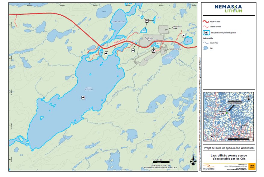
Source: Map Appendix, Nemaska Lithium, December 2014
Proposed Mitigation Measures, Monitoring and Follow-Up
The Proponent undertakes to establish various mitigation measures to reduce the adverse effects of the Project on the current use of lands and resources for traditional purposes, such as:
- With the Cree tallyman, establish a beaver and black bear trapping program in the zone exclusively dedicated to the mine, prior to the start of construction work;
- Turn over materials obtained during clearing in all phases of the Project to Cree users of the area or to the Nemaska community;
- Relocate camps, if necessary, as agreed during discussions with the affected Cree tallyman and his family;
- Limit the disturbance and mortality of wildlife resources harvested by the Cree Nation of Nemaska due to the mining operations (see Appendix A, noise environment and land vegetation measures);
- Install a fence around the pit during the decommissioning phase to restrict access to it by large wildlife;
- Stop all mining activity (blasting, rock piling, etc.) during the spring goose hunting season (Goose Break);
- Determine a blasting schedule jointly with the Environment Committee created under the Resource Development Partnership Agreement;
- Limit hunting pressures caused by the presence of workers;
- Prohibit wildlife harvesting activities (hunting, fishing and trapping) by employees within the area of the mining lease and surface use leases;
- Allow access to beaches located to northeast of Lac des Montagnes.
The Proponent undertakes to keep Cree users of the area informed of the schedule of mining activities to facilitate management and, as necessary, to reorganize their harvesting activities.
A number of previously described mitigation and follow-up measures designed to reduce the Project's effects on water and air quality, terrestrial and wetland environments, migratory birds, and fish and fish habitat would also contribute to reducing the impacts on the current use of lands for traditional purposes (see Appendix A).
The Proponent undertakes to establish a program to monitor the use of the land by the Crees and to document the presence of large wildlife specimens near the mine site in order to confirm the effectiveness of these measures. According to the Proponent, monitoring processes are discussed with the Grand Council of the Cree (Eeyou Istchee), the Cree Nation Government and the Cree Nation of Nemaska. The monitoring would enable users of the land to give feedback on the effectiveness of the mitigation measures and propose changes if necessary.
Predicted Residual Effects
According to the Proponent, the significance of the residual adverse effects on current use of the territory and resources for traditional purposes would be moderate. The effect would be of moderate magnitude, considering that the current use of part of the area and the resources of trapline R20 would be modified, that the extent would be local and the duration would be moderate, given that the effect would be felt throughout the entire Project lifecycle, but would end when the Project is completed. Furthermore, given that the terrestrial environments in the study area are relatively homogeneous, land-based wildlife, including the woodland caribou, could use similar environments along the borders of the mine site, in the study area or in the adjacent region.
7.3.2 Views expressed
Federal Authorities
According to Environment Canada, the likelihood of finding woodland caribou in the study area is low given that the habitats present in the study area do not have the characteristics sought by this species. Furthermore, population monitoring performed over several years confirms that woodland caribou rarely, if ever, occur in this area. Given the low potential for the presence of woodland caribou in this area of the mine, Environment Canada considers the mitigation measures put forward by the Proponent to limit the Project's effects on the woodland caribou to be adequate.
Environment Canada recommends the implementation of a monitoring program for all wildlife species listed in the Species at Risk Act, including the woodland caribou.
Aboriginal Groups
The Cree Nation of Nemaska expressed a number of concerns about the current use of lands and resources for traditional purposes. They are presented in Appendix E. Some of these concerns deal with the disturbance of wildlife (Canada geese and moose) and hunting and fishing pressures by mine workers.
In response to these concerns, the Proponent reviewed the mine site layout to move the infrastructure further away from Lac des Montagnes and waterfowl hunting areas. Based on the update of noise impact study modelling following the relocation of infrastructure, the Proponent is of the view that there would be little if any notable significant effect on the noise environment in waterfowl hunting areas. Stopping activities causing noise during the "Goose Break" is one of the measures to be taken to address this concern. With respect to moose, its home range is five to ten square kilometers according to the Government of Quebec. Moose that currently occur in the site targeted by the mine Project would move to other areas of trapline R20.
In addition to prohibiting future employees from hunting or fishing on lands within the area of the mining lease and surface use leases, the Proponent would prohibit anyone in possession of a weapon of any kind on the mine site, except duly authorized individuals. The Proponent undertakes to hold discussions with the Cree Nation of Nemaska, the Quebec Department of Sustainable Development, Environment and the Fight against Climate Change, as well as the Société Weh-Sees Indohoun to oversee hunting and fishing by workers of the Eastmain-1-A–Sarcelle–Rupert Project and other users of the territory, including the Whabouchi Mining Project. As for hunting and fishing in neighbouring areas, workers should comply with the applicable regulations in the Weh-Sees Indohoun and Eastmain sectors.
The Cree Nation of Nemaska has voiced concerns about revitalization of the mine site. It mentions that many industrial sites have been abandoned, with waste being left behind (barrels, propane tanks and metal structures). The Proponent has undertaken to manage and treat waste generated during construction, operation, restoration and site closure. As mentioned earlier, restoration and revegetation work at the mining site would be performed by the Proponent.
7.3.3 Agency analysis and conclusion
Analysis of the effects
The Agency asked the Proponent for additional information on the Project's possible impacts on nearby traplines, plant species harvested by the community of Nemaska, fishing and the integration of traditional knowledge in the environmental assessment of the Whabouchi Project. The Agency notes that users of the land, members of the community and Cree experts have had multiple opportunities to share their knowledge of plant and wildlife species and their use of the land.
At the Agency's request, the Proponent provided a map showing the lakes used by the Cree Nation of Nemaska for their water supply. The safety zone around the mine site, which would encompass Lakes 1, 2 and 28, would prevent the Cree from using them as a water supply source. The safety zone would also cause the loss of a little over 9 square kilometers of land for hunting, fishing, trapping, berry picking, access to hunting camps and roads. Following site restoration, there will be a loss of suitable wildlife habitat due to the presence of the pit and pile. The Agency believes there would be no significant impact on woodland caribou since this species is unlikely to occur in the study area.
The Agency is of the view that several previously described mitigation and follow-up measures designed to reduce the Project's effects on water and air quality, terrestrial and wetland environments, migratory birds, and fish and fish habitat would also contribute to reducing the effects on current use of lands for traditional purposes (see Appendix A). The Agency believes that informing the Cree Nation of Nemaska of the results of these monitoring programs would alleviate their perception of the risk of contamination generated by mining activities.
The measure proposed by the Proponent to control hunting, fishing or trapping on mine property partially addresses the issue raised by the Cree that falls within the jurisdiction of the Quebec Department of Forests, Wildlife and Parks of Quebec. The Cree Nation of Nemaska will have to discuss the mechanisms to be implemented to resolve this issue with the Quebec government. The Proponent has informed the Quebec government of this concern.
The Agency believes that the residual adverse effects on the current use of land and resources in the Lac des Montagnes, Lac du Spodumène and Nemiscau River areas would not be significant (see Appendix F) following the implementation of the mitigation measures proposed by the Proponent and the additional measures specified by the Agency and set out below. The magnitude of the effects would be moderate considering the changes in the use of the land, but the integrity of the use would not be compromised. The extent of the effects would be local considering that the changes would be felt beyond the Project's footprint, although they would be limited to the southwest section of trapline R20. The duration of the effects would be long-lasting given that several changes in the use of the land would persist after the mine's closure, particularly in relation to the fact that the pit would become a water body rather than a terrestrial environment. The effects on current use of lands would be partly reversible given that access to the land would once again be possible following mine closure, including access to lakes used as drinking water sources, and that resource avoidance may be less frequent. Changes in habitat, such as the pit and the waste rock and tailings pile, would nevertheless be permanent.
Key Mitigation Measures to Avoid Significant Effects
The Agency considered the mitigation measures proposed by the Proponent, the opinion of expert federal authorities, the comments of Aboriginal groups and the public to identify key mitigation measures which are required so that the Project causes no significant environmental effects on the current use of lands and resources for traditional purposes by Aboriginal persons:
- In consultation with the Cree tallyman, the Cree Nation of Nemaska and the Cree Nation Government, shall determine the optimal location of the effluent pipe in the Lac des Montagnes, taking into consideration the Cree Nation's fishing areas;
- In consultation with the Cree Nation of Nemaska, shall determine a safety zone with respect to the Project for the purpose of ensuring public safety;
- Shall prohibit its employees and contractors from hunting, fishing and trapping within the limits of the mining lease and surface use leases unless an employee or a contractor is provided access for traditional purposes or for exercising Aboriginal or treaty rights, in which case such access will be in accordance with all rules established by the Proponent with respect to the safety zone;
- Shall develop and implement a communication plan in consultation with the Cree Nation of Nemaska in order to keep the Cree Nation of Nemaska informed of the Project schedule and any updates or revisions to that schedule as stated and of the results of the wildlife species of interest follow-up programs. Implementation of the communication plan shall begin with the start of construction and end following decommissioning;
- In consultation with the Cree tallyman, the Cree Nation of Nemaska and the Cree Nation Government, shall develop a program for the management of beaver, black bear and the recuperation of harvested wood for the use of the Cree Nation of Nemaska in the Project area prior to construction;
- Shall, in consultation with the Cree Nation of Nemaska, develop and implement a follow-up program to monitor the presence of wildlife species of interest in the Project area and to develop and implement corrective measures to mitigate adverse effects of the Project on those wildlife species of interest. The follow-up program shall begin with the start of construction and end following decommissioning;
- Shall, in consultation with the Cree Tallyman and the Cree Nation of Nemaska, undertake progressive reclamation of the habitats impacted by the Project.
Conclusions
Taking into account the implementation of mitigation measures and follow-up programs put forward by the Proponent concerning terrestrial and wetland environments, migratory birds and fish and fish habitat, and the key measures described earlier, the Agency does not believe that the Project has the potential to cause significant adverse effects on the current use of lands and resources for traditional purposes.
7.4 Aboriginal People – Health and Socio-Economic Conditions
7.4.1 Proponent's Assessment of environmental effects
This subsection of the report deals more specifically with the effects of the environmental changes on Aboriginal health and socio-economic conditions. The following aspects are most relevant considering the Project and territory in question:
- Health effects resulting from the presence of contaminants in traditional sources of food obtained from hunting, fishing and berry gathering;
- Health effects caused by changes in air and water quality.
Predicted Effects
According to the Proponent, the modelling confirms that air emissions will not have any effect on fishing and trapping camp sites, or on berries since the consumption of traditional food (large wildlife, waterfowl, fish and berries) was considered in the air quality modelling. The Proponent found that the Project would have little effect on air quality outside the mine site (Section 6.1).
Water quality from the lake des Montagnes would also be relatively unaffected given the low levels of contaminants anticipated in the effluent, the low potential for acid drainage from waste rock and tailings, compliance with the Metal Mining Effluent Regulations and control of domestic wastewater (Section 6.2). The Nemaska Cree draw water from several points as described in Section 7.4. These lakes would no longer be accessible during operation of the mine but would become available to the Cree again after the mine closes. With the exception of Lac des Montagnes, Lakes 1, 2, 5, 6, 18 and 28 are located upstream from the mine wastewater treatment plant discharge point (final effluent). The Proponent will comply with provincial and federal criteria concerning surface and underground water quality, including that of Lac des Montagnes and the small lakes mentioned above.
On the basis of these findings, the Proponent determined that the changes in water and air quality would have no effects on the health or socio-economic conditions of the Cree.
Proposed Mitigation Measures
The Proponent undertakes to implement mitigation measures (Appendix A) to control changes in air and water quality that would be likely to have adverse effects on health and socio-economic conditions. In particular, the Proponent undertakes to:
- Implement a dust management program and appropriate dust control, impose a speed limit of 30 kilometers/hours for vehicles at the Project site and carry out the progressive restoration of the waste rock and tailings storage pile;
- Implement a program for managing waters that come into contact with mine tailings, including mine water and water from the waste rock and tailings storage pile, to ensure its collection and treatment prior to being discharged to the environment at a final discharge point. Final effluent will be treated to meet the water quality criteria, adjusted according to the environmental discharge objectives set by the government of Quebec, as well as the standards of the Metal Mining Effluent Regulations.
In addition to its commitment to comply with air and water quality standards, the Proponent would adequately monitor the situation and, as necessary, find solutions to minimize the risks to the health of the population by:
- Monitoring air quality and atmospheric emissions;
- Monitoring dust deposition near the site through the installation of dustfall gauges;
- Monitoring water and sediment quality;
- Monitoring benthic communities;
- Monitoring fish populations and fish tissue contamination;
- Developing a strategy for communicating monitoring results to the Cree Nation of Nemaska.
As applicable, the Proponent would use the results of the various monitoring activities to identify other mitigation measures in an adaptive management approach.
Predicted Residual Effects
The Proponent believes that the negative residual effects on the health of Aboriginal peoples caused by the consumption of country foods should be minor given that contaminants releases should meet federal and provincial standards governing emissions and discharges.
7.4.2 Views expressed
Federal Authorities
As suggested by Health Canada, the Agency asked the Proponent to assess the potential effects of changes to the environment (e.g., air quality, noise environment, water quality, potential decrease in the quality of traditional foods) on the health of users of the land in the study area. In response to this request, the Proponent demonstrated that there was a low probability of contamination based on compliance with environmental protection emission thresholds for air pollutants or aquatic environment pollutants. Health Canada is of the view that the Proponent's case is not conclusive because the thresholds used are not necessarily based on human health effects and do not take account of either the quantity of traditional food consumed by Aboriginal people or the contaminant levels in this food. These thresholds may therefore be insufficient for assessing the health risks associated with the consumption of traditional foods.
Although the results of air quality modelling suggest that there would be no exceedances of atmospheric emissions standards outside the mine site or at the 23 sensitive receptor sites, i.e., the 22 Cree camps and the Bible Camp, the Proponent has undertaken to perform various monitoring activities, including the monitoring of dust deposition near the site to take corrective actions to minimize the health risks to the Cree Nation of Nemaska as necessary.
As discussed in Section 6.1, Environment Canada believes that dustfall, especially if it contains metals and non-metals, could affect the quality of surface water in water bodies located near the mine facilities. The Proponent has proposed to implement a water quality monitoring program in water bodies located near the mine site, including Lakes 2, 18 and 28, used by the Cree as a source of drinking water. Following discussions with the Agency, the Proponent has undertaken to add Lakes 1 and 6 to the monitoring program in order to address the concerns expressed by the Cree with regard to that resource, due to their proximity to the mining facilities.
Aboriginal Groups
The Cree Nation of Nemaska has concerns about the potential contamination of lakes, streams and drinking water sources as a result of the use of explosives and the presence of the waste rock and tailings storage pile, and fears the emergence of human health problems from eating fish. The Proponent has undertaken to implement a program to manage dust and water flowing on the mine site and to take various measures to reduce feed of contaminants (see Appendix A). The Proponent has undertaken to monitor air quality, water quality and fish tissue contamination. According to the Proponent, the results of the air and water quality monitoring would dispel the fears and concerns of Cree users and mitigate the potential avoidance of resource harvesting (wildlife, aquatic life and plants) due to perceived contamination.
According to Health Canada, compliance with environmental regulations (concerning air emissions and waste water, for example) may not guarantee that human health will be protected given that such regulatory standards and criteria do not necessarily take into account all exposure pathways (e.g., ingestion) or the possibility that some contaminants may be transferred to the food chain and bioaccumulate or biomagnify in various links ingested by Aboriginal people as traditional food.
The Cree are also concerned that their lands will be contaminated by overflows of the flooded pit following closure of the mine site, as well as overflow or leaks from settling ponds. In response to this concern, the Proponent reviewed the site plan for these ponds and moved them further away from the Lac des Montagnes.
The Cree Nation of Nemaska has asked the Proponent to provide more information on the effect of inhaling dust generated by mining activities on the health of users of hunting, fishing and trapping camps, and on the consumption of harvested products (wildlife, plants and berries). Among other things, the community would like to know whether this dust might be toxic. According to the Proponent, spodumene concentrate is an inert, non-toxic compound that poses no serious threat to aquatic or terrestrial plants and animals, and presents no tendency to bioaccumulate.
The Proponent is also of the view that there will be no exceedances of the criteria applicable to mining effluent under the Metal Mining Effluent Regulations or of the air quality standards under the Quebec Clean Air Regulation.
The Cree Nation of Nemaska also voiced concerns about eating the meat of Canada geese that could be contaminated by water from the settling ponds or flooded mine pit or by berries eaten by the birds near the mine site. The Proponent stated that the tests conducted have shown that the anticipated metal levels in the ponds would not pose a significant risk to the health of birds.
7.4.3 Agency analysis and conclusion
Analysis of the effects
The Agency notes that the changes made to the location of the mine infrastructure and the programs proposed to control dust and pollutants load rejected to the environment would be effective in reducing the effects on health conditions.
Given that air quality should meet provincial and federal criteria, the Proponent concludes that the potential for accumulation of dust on trapline R20 is limited. According to the Agency, there remains some uncertainty regarding this conclusion since dust deposition rates were not modelled in the Proponent's analysis. The Agency notes that the question of dust contamination is at the heart of the concerns of the Cree Nation of Nemaska, that the consumption of traditional food is part of their way of life, and that any damage to the quality of traditional food could have an effect on Cree health conditions. Given the concerns raised by Environment Canada regarding the attainment of the dust control objectives and the fact that fish and berries are the elements most likely to be contaminated by dust, the Agency is of the view that rigorous implementation of a dust management program is key to compliance with the applicable ambient air standards.
With respect to the Project's potential adverse effects on the quality of water that might be used for drinking, the Agency is of the view that the measures required to ensure compliance with standards and monitoring requirements under the Metal Mining Effluent Regulations, as well as the water quality criteria prescribed in the government of Quebec's Directive 019, as listed in Section 7.1, would reduce the risk of contamination of the drinking water supply. As described in Section 6.2, the sampling performed by the Proponent shows that there are currently exceedances of the bacteriological standards of Quebec's Regulation Respecting the Quality of Drinking Water for total coliform in several of the water bodies used by the Cree Nation of Nemaska. To ensure that the Project does not put more contaminants in water bodies used by the Cree during operation and after closure of the mine, the Agency is of the view that water quality monitoring in Lac des Montagnes as well as Lakes 1, 2, 6 18 and 28 is necessary, applying the Canadian Drinking Water Guidelines.
The Agency believes that the adverse residual effects on the health and socio-economic conditions of Aboriginal people would not be significant (see Appendix F) following implementation of the mitigation measures put forward by the Proponent. The magnitude of the effect would be low considering compliance with air quality standards, the anticipated low level of contaminants in the effluent and the low potential for acid mine drainage from waste rock and tailings. The extent of the effect would be local, given that the effect would extend beyond the Project's footprint, although it would be limited to the immediate vicinity of the Project site. The duration of the effect would be long-term given that the effect on water quality could persist after the mine closure. The effects on health conditions would be reversible given that the emission of potential contaminants should cease with the mine's closure.
Key Mitigation Measures to Avoid Significant Effects
Changes to the site plan are the most effective mitigation measure in the circumstances, although the Agency has determined that implementation of the following mitigation measures, in addition to the mitigation measures and follow-up provided in Section 7.1, is required to ensure that the Project will not cause significant adverse effects on health and socio-economic conditions.
- Shall, during all phases of the Project, implement mitigation measures to manage air emissions of the Project which shall include:
- use of dust-control products;
- a 30 kilometers/ hour speed limit for vehicles on the Project site; and
- progressive reclamation of the waste rock and tailings pile.
Need for Follow-up and Requirements of Follow-up
In order to verify the accuracy of the environmental assessment of the Project and to determine the effectiveness of the mitigation measures, shall develop and implement a follow-up program on health and socio-economic conditions that shall include:
- Monitor the air quality at the Bible Camp and at hunting camp most likely to be affected by the Project using the Canadian Council of Ministers of the Environment's Canadian Ambient Air Quality Standards and the Quebec Clean Air Regulation as benchmarks. Air quality monitoring shall be implemented from the beginning of construction until the completion of the decommissioning phase;
- Notify the Cree Nation of Nemaska if monitoring shows exceedances of the Canadian Council of Ministers of the Environment's Canadian Ambient Air Quality Standards or the Quebec's Clean Air Regulation, and, if necessary, implement additional mitigation measures; and
- Monitor, every three years, heavy metal concentrations in the flesh and livers of walleye, northern pike and lake whitefish in Lac des Montagnes and Lac du Spodumène. The monitoring program shall be implemented when construction begins and end five years after the decommissioning phase is completed;
- Shall, in consultation with the Cree Nation of Nemaska, develop and implement a plan for communicating the results of the monitoring programs to the Cree Nation of Nemaska, as well as any corrective measures to be taken. Shall implement this communication plan form the beginning of construction until the completion of decommissioning.
Conclusions
Taking into account the implementation of the mitigation and follow-up measures described earlier, the Agency is of the view that the Project would not have significant adverse effects on the health and socio-economic conditions of Aboriginal peoples.
7.5 Aboriginal People - Physical or Cultural Heritage, and Effects on Historical, Archeological, Paleontological or Architectural Sites or Structures
On the land concerned by the Project, archaeological heritage is the first component examined in this section. The second component examined relates to cultural heritage, which more specifically addresses the Project's potential effects on the Bible Camp and the multiple activities associated with it. A number of social issues, such as cultural erosion and the presence of alcohol and drugs, were brought to the Agency's attention. Given that monitoring these issues is the responsibility of the Quebec government, they were not addressed in the federal environmental assessment of the Whabouchi Project.
7.5.1 Proponent's assessment of environmental effects
The inventory that was conducted following the study of archaeological potential did not uncover any artefacts. Interviews with tallymen generated relevant information on the location of old camps or facilities. No artefacts of human settlement prior to the 1950s were identified during the archaeological inventories.
The Cree Nation of Nemaska has identified valued sites and birth site, as well as a gathering site, the Bible Camp, in the Project study area. The Bible Camp, a significant site to the Cree Nation of Nemaska, provides a gathering place for families during cultural and religious events and a summer camp for the community's youth. Located on the edge of the Lac des Montagnes, it is also the site of numerous recreational activities, such as fishing, swimming and canoeing.
Predicted Effects
The mine's presence and operation could affect the tranquil nature of the Bible Camp and its use, particularly due to:
- The limited access to the Lac des Montagnes;
- Noise nuisances;
- Landscape deterioration.
The limited access to the Lac des Montagnes was addressed in the context of its use by local users in Section 7.4 (current land use). The Proponent has undertaken to maintain access to the beaches located to the northeast of the Lac des Montagnes despite encroachment by the safety zone set up by the Proponent on these beaches. Other beaches on the same lake remain accessible since they are not located within the mine security zone.
Changes to terrestrial and wetland environments caused by the waste rock and tailings storage pile could alter aspects of the landscape with the addition of infrastructure located near the Bible Camp and Cree camps, and could become a nuisance to the Cree Nation of Nemaska. However, visual simulations performed by the Proponent indicate that the stockpile would not be highly visible from the mouth of the Nemiscau River in the Lac des Montagnes, where the Bible Camp and Cree camps closest to the mine site are located. The final effluent discharge pipe in the Lac des Montagnes will be buried over a distance of approximately 100 meters before it enters the Lake in order to limit the visual impact on the Lake users.
With respect to noise nuisance, as described in Section 6.3, the Proponent does not expect the Project to have any significant effects on the sound quality perceived at the various Cree camps or the Bible Camp.
Proposed Mitigation Measures
The Proponent undertakes to implement various measures to limit the effects, particularly in relation to:
Archaeological artefacts:
- In the event that any archaeological artefacts are accidentally discovered during the work, the archaeological site(s) discovered will be managed in accordance with the requirements of the Quebec Cultural Property Act (R.S.Q., c. B-4);
- If archaeological artefacts are discovered at the mine site, supervisors are required to report the discovery immediately to the Project manager and, as necessary, halt work at the location of the discovery until it can be fully assessed by archaeologists. Nemaska Lithium would inform the Cree tallyman and Cree authorities, among others.
The Bible Camp and its activities:
- Prohibit pit blasting between 7:00 p.m. and 7:00 a.m.;
- Assess the possibility of relocating the Bible Camp if necessary;
- Bury the effluent discharge pipe over a distance of approximately 100 meters along the shoreline and in the initial part of the littoral area to limit the visual impact on users of the Lac des Montagnes, including the Bible Camp;
- Carry out progressive revegetation of the waste rock and tailings storage pile and restore the mine site after its closure.
In addition to these measures, the Proponent plans to establish measures to reduce noise and visual nuisances (including lights) (see Appendix A).
To confirm the effectiveness of these measures, the Proponent undertakes to create a Bible Camp user monitoring program and conduct specific monitoring for noise and vibration at the Bible Camp. Users could assess the mitigation measures and suggest adjustments to them. The mechanisms involved in this monitoring were discussed between the Proponent, the Grand Council of the Crees (Eeyou Istchee), the Cree Nation Government and the Cree Nation of Nemaska.
Predicted Residual Effects
Given that no historical or archaeological artefacts have been found in the Project study area, no potential effects on the archaeological heritage are expected during the work planned on mine property.
According to the Proponent, the significance of the residual effect on the Bible Camp and its activities would be moderate following the implementation of mitigation measures.
7.5.2 Views expressed
Aboriginal Groups
A number of members of the community voiced concerns about the possibility that the visual and auditory impacts of mine operations will disrupt use of the Bible Camp.
In response to these concerns, the Proponent reviewed the mine site layout to move the infrastructure farther away from the Lac des Montagnes. The waste rock and tailings storage pile would be installed to the north of Route du Nord. Mine water ponds and the overburden storage pile would also be relocated more than 750 meters from the Lac des Montagnes.
7.5.3 Agency analysis and conclusion
Analysis of the effects
Changes made to the mine layout plan made it possible to move sources of nuisance away from the Bible Camp. The updated modelling of the noise environment performed following changes made to the site plan confirms the absence of any significant effects on the Bible Camp. Visual simulations by the Proponent and submitted to the Provincial Review Committee (Roche, April 2014) indicate that the waste rock and tailings storage pile would be invisible from the area at the mouth of the Nemiscau River in the Lac des Montagnes, where the Bible Camp and Cree camps closest to the mine site are located.
The Agency is of the view that the negative residual effects on Aboriginal physical and cultural heritage will not be significant (see Appendix F) following implementation of the mitigation measures put forward by the Proponent. The magnitude of the effect will be low given that studies and inventories have not uncovered any artefacts, and visual simulations and air quality and effluent modellings indicate a limited effect on the environment. The extent of the effect would be local considering that the archaeological heritage effect would be limited to the site of the Project, but the effect on the environment could extend beyond the Project's footprint to the Bible Camp over 1 kilometer away. The duration of the effects would be long-term given that the visual nuisance related to the presence of the waste rock and tailings storage pile would persist after the mine's closure. However, the nuisances in question would be minor. The effects on heritage would be partly reversible considering that the visual nuisance surrounding the waste rock and tailings storage pile would persist after the mine's closure, but the effects related to air quality and noise would cease once the mine is no longer in operation.
Key Mitigation Measures to Avoid Significant Effects
Changes to the mine layout plan are an effective mitigation measure, but the Agency has determined that the following key mitigation measures that would prevent significant adverse residual effects on the "physical and cultural heritage or any structure, site or thing that is of historical, archaeological, paleontological or architectural significance" component would be necessary:
- In the event that archaeological remains or artefacts are discovered in the Project area, shall:
- halt work at the location of the discovery;
- have a qualified individual conduct assessment at the location of the discovery;
- inform, in writing, the Cree tallyman directly affected by the Project, the Cree Nation of Nemaska and the Cree Nation Government forthwith; and
- comply with any legislative or legal requirements respecting the discovery of archeological remains or artefacts.
- Shall implement the following mitigation measures to reduce visual nuisance:
- burial of the effluent pipe at least 100 meters away from the shoreline and in the littoral zone in accordance with the Fisheries and Oceans Canada requirements, in order to prevent or reduce serious harm to fish;
- progressive re-vegetation of the waste rock and tailings pile;
- reclamation of the mine site after decommissioning is completed.
- Shall, subject to the safety requirements of the Project and the safety zone established, ensure access to the Lac des Montagnes, in the north-east sector, so that the users of the Bible Camp can carry on all their activities on the lake and its shores, such as swimming and canoeing;
- Shall, during all phases of the Project, develop and implement a noise-level follow-up program at the Bible Camp and the hunting camp most likely to be affected to verify that the noise levels originating from the Project respect the noise levels set out in the Note d'instructions du Québec 98-01 sur le bruit;
- Shall develop and implement a plan for communicating the results of the follow-up program to the Cree Nation of Nemaska and shall consult the Cree Nation of Nemaska concerning implementation of any corrective measures.
Conclusions
Taking into account the implementation of mitigation measures described earlier, the Agency is of the view that the Project would not have significant adverse effects on natural or cultural heritage.
8 Other Effects Considered
8.1 Effects of the Project on Species at Risk
The Agency has assessed the Project's adverse effects on the species and critical habitat listed under the federal Species at Risk Act as required by subsection 79(2) of this act. Species at risk likely to be affected by the Project are the olive-sided flycatcher, common nighthawk, rusty blackbird, short-eared owl, woodland caribou, wolverine, little brown myotis and Northern myotis.
The significance of the Project's effects on species at risk that constitute environmental components to be considered in applying the CEAA 2012 is addressed in the valued components discussed in Chapter 7. The Project's effects on migratory birds at risk are covered in Section 7.2, and the effects on woodland caribou are covered in Section 7.3 since this species is hunted by the Cree Nation of Nemaska.
8.1.1 Proponent's assessment of environmental effects
Short-eared owl and rusty blackbird
The short-eared owl and the rusty blackbird are not protected by the 1994 Migratory Birds Convention Act, but they are listed as species of concern under the federal Species at Risk Act. According to the Proponent, the potential habitats of the short-eared owl and of the rusty blackbird in the Project zone are primarily found on the Lac du Spodumène bog. The Proponent estimated that one to three short-eared owl pairs could leave on the Spodumène bog during the prey average abundance period, and of one rusty blackbird breeding pair.
Proposed mitigation measures
The Proponent is committed to implement a number of mitigation measures for migratory birds (Section 7.2) that would reduce the impacts of the Project on the short-eared owl and rusty blackbird (see appendix A). The Proponent commits to implement the following measures:
- Protect all nests found using a buffer zone based on an adequate distance of protection to the species until the chicks have left the vicinity of the nest on a permanent basis. The adequate distance of protection may vary significantly according to the species: 300 meters for the rusty blackbird and 500 meters for the short-eared owl;
- Conduct an inventory of the short-eared owl in the Lac du Spodumène bog before the beginning of construction to determine whether the site is used;
- Monitor the effects of the drawdown of the water table on the Lac du Spodumène bog which includes monitoring the avian wildlife at risk in the breeding season.
Anticipated residual effects
The Proponent considers the effects of the loss of habitat for the short-eared owl low given the small area affected (0.0037 square kilometer) and because there would be no breeding pairs of the species affected by this habitat loss. According to the Proponent, the main effect of the Project on this species will be caused by the disturbance (artificial lighting, noise, human presence). The Proponent estimates the area loss to 7.2 ha and one breeding pair for the rusty blackbird. As described in Section 7.2, the Proponent considers that the significance of the residual effect on bird species at risk (including the short-eared owl and rusty blackbird) would be moderate taking into account the low number of breeding pairs that would be affected.
Bats
The range of the Northern myotis (Myotis septentrionalis) and little brown myotis (Myotis lucifugus), two species designated endangered under the federal Species at Risk Act, also includes the study area. The inventories performed show that the Northern myotis and the little brown myotis could be present in the study area near the Lac du Spodumène. A maternity colony of approximately 300 little-brown myotis is located 625 meters east of the mine site. This maternity colony has been monitored by the Quebec Government.
Wolverine
The study area falls within the range of the wolverine, species designated endangered under the Species at Risk Act. According to the Proponent, it is unlikely that wolverine occur in the study area given the presence of only a small number of large mammals, which form the bulk of the species' diet.
Proposed Mitigation Measures
The Proponent undertakes to implement various mitigation measures for mammals that could reduce the Project's effects on bats and wolverine, particularly in relation to sound and ambient light (see Appendix A). It also undertakes to implement the following measures specifically for the little brown myotis:
- Inform and raise worker awareness of the presence of the little brown myotis maternity colony near Route du Nord ;
- Perform annual monitoring of the number of specimens at the maternity colony near the Lac du Spodumène.
Anticipated Residual Effects
Although terrestrial environments in the study area are fairly homogeneous, and although terrestrial wildlife could move or use similar environments to those disturbed by mining operations near the site, the Proponent considers the significance of the residual effect on bats to be moderate given the proximity of the maternity colony used by the species to the mine infrastructure.
No effects are anticipated on wolverine taking into account that it is not likely he is present in the zone of study.
8.1.2 Views Expressed
Federal Authorities
Short-eared owl and rusty blackbird
According to Environment Canada, the shrub cover in the large peat bog of Spodumène may make it unsuitable for the short-eared Owl, which is associated with herbaceous plant habitats. The Department recommends that the use of the Lac du Spodumène bog by the short-eared owl be confirmed before the start of construction and that in the event this bog is used by the species, that the Proponent proposes and applies additional mitigation measures during the breeding season. As described in Subsection 7.2.2, Environment Canada proposes a follow-up program for the migratory birds at risk, as well as for the rusty blackbird and the short-eared owl. Environment Canada recommends that compensation projects for wetlands (Subsection 6.4.2), proposed by the Proponent, take into account the establishment and protection of desirable habitats for the rusty blackbird.
Bats
According to the Committee on the Status of Endangered Wildlife in Canada status report on the little brown myotis and Northern myotis, the effects of mining activities during exploration and extraction stages could become a concern if noise and vibration disturb hibernating bats.
Noise caused by vehicle traffic could cause the bats to change their hunting patterns, and increased road system density could reduce the size of available feeding areas.
Considering that the Project would not significantly increase noise and light in the little brown myotis maternity colony, and that the bats will be able to move into other environments to feed during the life of the mine, the effects on the maternity colony should be limited. Environment Canada believes that the mitigation measures proposed by the Proponent to limit noise and light generated by mine activities are essential in order to reduce the adverse effects of the Project on bats (Subsection 7.2.3).
Wolverine
Environment Canada confirms that the potential for the presence of wolverine in Quebec is low, and believes that the mitigation measures proposed by the Proponent for small and large mammals (Appendix A) would be suitable to reduce the risk of adverse effects on the species. Environment Canada considers the significance of the residual effect on this species to be low to negligible.
Public
One member of the public expressed concern about the Project's potential effects on the little brown myotis given the species' vulnerability. To limit any possible effect of the Project on the little brown myotis maternity colony located near the Lac du Spodumène, the Proponent undertakes to perform annual monitoring of the number of specimens in the maternity colony.
8.1.3 Agency analysis and conclusion
The Agency has determined that the measures the Proponent would implement and key mitigation measures described in Section 7.2 to reduce adverse effects on migratory birds would avoid disturbing the short-eared owl and the rusty blackbird and their recovery.
Noise and light are two factors identified by Environment Canada as potentially harmful to bats. Given these factors and the proximity of the little brown myotis maternity colony, the Agency recommends that the Proponent implement the proposed mitigation measures to reduce noise and the intensity of light generated by the Project (Subsection 7.2.3). These measures could prevent harm to the species or to their recovery.
Given the limited possibility of the wolverine's presence in the study area, the Agency has no specific recommendations regarding this species.
8.2 Proponent's Assessment of Accidents and Malfunctions
Accidents and malfunctions can occur at various phases of the Project, from construction of the mine site to the post-closure phase.
The Proponent evaluated and estimated the technological risks based on criteria that take into account the severity of the consequences of an undesired event, the probability that such event would occur, the level of uncertainty (about the consequences and probable occurrence) and the risk acceptability criteria. The estimated level of risk takes account of the prevention and mitigation measures implemented.
The Proponent conducted an overall analysis of technological risks, including risks to workers and the public, environmental risks and property risks. The analysis did not identify any high technological risks. The risks most likely to affect the environment are associated with potential surface or groundwater contamination. Such contamination could occur as a result of the storage or handling of petroleum and chemical products or the occurrence of a fire (see Table 8).
For the risks identified, the Proponent undertakes to ensure the effectiveness of control measures and mitigation plans, and to ensure procedures are in place. Considering that the mine site is located far from resources that could be deployed in the event of a major accident, the Proponent would provide the necessary resources to respond diligently in the event of a major accident. It also intends to establish mutual assistance agreements with other companies in the area as well as the Cree Nation of Nemaska in order to share emergency response resources.
|
Hazard Identification |
Descriptionof Risk |
Consequences* |
Probabilities* |
Uncertainty level* |
Risks* |
|---|---|---|---|---|---|
|
* H: high; M: moderate; L: low. Source: Environmental and Social Impact Assessment, Nemaska Lithium, March 2013 |
|||||
|
Petroleum products (fuel oils, fuels) |
Spill |
M |
L |
L |
M |
|
Petroleum products (fuel oils, fuels) |
Fire |
H |
L |
L |
M |
|
Petroleum products (oils, greases) |
Spill |
L |
L |
L |
L |
|
Miscellaneous chemical products |
Spill |
M |
L |
L |
M |
8.2.1 Predicted Effects and Mitigation Measures Proposed by the Proponent
Petroleum Product Spills
The Proponent's impact assessment indicates that petroleum product spills could contaminate surface and groundwater as well as soil. Spills could result from multiple causes: corrosion and breakdown of storage equipment and vehicles, accidents causing spills from vehicles during shipment, and human error during maintenance or refueling.
Proponent's Prevention and Mitigation Measures
- Use double-wall petroleum product storage tanks;
- Establish methods for detecting hydrocarbon levels in tanks and preventing spills;
- Provide spill containment devices in storage, distribution and use areas (i.e., slabs);
- Provide a water-hydrocarbon separator in the fuel storage area;
- Establish hydrocarbon receiving and distribution procedures with employee training;
- Provide double-wall daily supply tanks;
- Keep spill kits with absorbents on site;
- Train and raise awareness about environmental protection among employees;
- Establish an emergency plan with a specific response procedure.
Fire
According to the Proponent's impact assessment, a fire could occur in the processing plant, fuel storage areas, or daily supply tanks, as well as during the shipping and distribution of daily supply tanks. Causes can include hydraulic oil and lubricant leaks, welds on equipment with an interior rubber lining and conveyor belt friction. Fires could result in the contamination of surface water, groundwater and soil.
Proponent's Prevention and Mitigation Measures
- Use lubricants and hydraulic oils with a low flashpoint;
- Maintain conveyors and equipment to prevent belt slippage and friction and prevent hydrocarbon leaks and spills;
- Control wildling of equipment using an interior rubber lining;
- Base fire prevention measures on National Fire Protection Association standards;
- Provide equipment to detect and fight fires and smoke, such as:
- a hydraulic fire-fighting system and fire hydrants at the conveyor and near the petroleum product storage area;
- a supply of foam to combat hydrocarbon fires;
- a 200,000-gallon US fire water system (757.1 cubic meters).
- Have a spill kit with absorbents.
- Establish an emergency response team.
- Have an emergency response plan in place with an alerting procedure and employee training.
Chemical Spills
According to the Proponent's impact assessment, a number of chemical products required by operations will be stored and transported, including vehicle fuels, lubricants, blasting explosives, reactants or additives for processing ore in the processing plant. Equipment failure and human error occurring during handling of these substances, as well as accidents during shipment could result in the spillage of hazardous products that would contaminate surface water and soil. Accidental chemical spills could occur during the use, maintenance or refueling of heavy machinery and vehicles.
Proponent's Prevention and Mitigation Measures
- Establish a maintenance program to prevent leaks caused by corrosion or equipment failure;
- Comply with the requirements of the Transportation of Dangerous Goods Regulations (SOR/2008-34) for products classified as dangerous goods;
- Create dedicated storage areas for chemical products and means for preventing and containing leaks, including tank level indicators equipped with alarms and containment basins for each tank;
- Have spill kits with absorbents on hand;
- Establish chemical handling and use procedures and provide employee training;
- Establish an emergency response plan with specific response procedures.
Mine Water Pond Dam Failure
The mine water pond dam would be the only dam used for the Project. For environmental reasons, the Proponent has opted to dispose of its tailings in filtered form, which does not require the installation of tailings ponds or dams.
With respect to the significance of the effects of a possible failure of the mine water pond dam, the Proponent stated that the pond would have a capacity of 26 000 cubic meters, which is small compared to the tailings pond dams generally installed on mine sites, which can reach several million cubic meters. The consequences of a dam breach for the Whabouchi Project would be the release of all or part of the water and slurry accumulated in the pond to the environment. The Proponent is of the view that these consequences would be limited considering the small capacity of the pond and the fact that it would be used only to settle out the suspended solids, with no further treatment, since the ore and waste rock will not generate acid drainage or leachable materials. Furthermore, the pond will be located 1 kilometer from the Lac des Montagnes and the land is gently sloped and covered with vegetation, which will trap the sediments. The Proponent does not expect any significant effects on the Lac des Montagnes.
Proponent's Prevention and Mitigation Measures
Although it has not analyzed the technological risks that could be associated with the failure of the mine water pond dam, the Proponent plans to implement a procedure for monitoring the soundness of the mine water pond dam (and other structures on site). This monitoring will involve systematic visual inspections performed year-round (daily, weekly and annual inspections or inspections following observed abnormalities). Any defect or failure in the dam would mean shutting off the water flow to the mine water pond. The dam would first have to be stabilized once the risks were assessed. The necessary repairs would be made to close (block) the breach and recover as much of the solids spilled downstream from the point of leakage or breach as possible. The resumption of the use of the mine water pond would not be permitted until it was inspected by a geotechnical expert. In this regard, the Proponent undertakes to conduct a geotechnical study in the summer of 2015 to validate the location of the accumulation areas and their future stability, as well as the location of the mine water pond dam. The Proponent also states that the dam was designed to exceed the safety criteria prescribed by Quebec mine regulations to withstand static and dynamic stresses.
Residual Effects According to the Proponent
The Proponent is of the view that the risk assessment process adopted and applied in the Whabouchi Project would ensure a low probability of residual negative effects following accidents or malfunctions. The Proponent would implement an emergency response plan that takes account of accidents and malfunctions. The emergency plan would identify the roles, equipment, response techniques and specific response procedures for risks of fire, explosions and spills of various petroleum and chemical products.
8.2.2 Views Expressed
Aboriginal Groups
The initial Project design called for two settling ponds located near the Lac des Montagnes. The Cree Nation of Nemaska expressed its concerns about the location of the ponds and the potential impacts in the event of an accidental spill from the ponds into the Lac des Montagnes. To address the concerns of the Cree Nation of Nemaska, the Proponent decided to review the initial Project design. The Project now consists of only one mine water pond, located farther away from the Lac des Montagnes, so that any potential failure of the pond dam would no longer pose a risk to the lake.
Federal Authorities
In the initial Project design, a mine water pond was located near the explosives depot. To limit the risk of a mine water pond failure in the event of an explosion, Environment Canada asked the Proponent to consider another site for the explosives depot. The Proponent now plans to have three small depots located at a distance from the new mine water pond, which was also relocated farther away from the Lac des Montagnes. According to Environment Canada, even though the mine water pond has been moved farther from the Lac des Montagnes to limit the risk of spills to the aquatic environment, there is still a risk of spill from the mine water pond or from the waste rock and tailings pile retention pond. The Proponent undertakes to monitor the soundness of the mine water pond dam and to take any necessary action to recover solids in the event of a dam failure. The Proponent believes that given the 1 kilometer distance between the dam and the Lac des Montagnes and the fact that the terrain at this location is gently sloped, sediment from a potential dam breach would be trapped by vegetation. Environment Canada is of the view that the assessment of the effects of a potential dam failure provided by the Proponent appears to be valid, and that it is reasonable to believe that the quantity of water and sludge that reached the lake would be limited. However, the Department recommends that the Proponent provide mitigation and contingency measures in its emergency response plan in the event of dam failure to limit the risk of environmental contamination, especially of soil and surface water.
Environment Canada also recommends that the Proponent identify specific measures for migratory birds in its emergency response plan, particularly for migratory bird species at risk, in the event of accidental spills, limits inadvertent exceedance of standards, migratory bird mortality or the observation of abnormal behavior in birds present in the mine water pond (a component to include in the environmental monitoring program). If such events or situations were observed, the Proponent should make the necessary corrections. As necessary, the Proponent could contact the Canadian Wildlife Service for advice on appropriate action.
8.2.3 Analysis of Effects and Agency Conclusion
Analysis of Effects
The Agency is of the view that the Proponent has identified and assessed the potential accidents and malfunctions associated with the Project and that it has taken into account the concerns of the Aboriginal groups and federal authorities regarding the risk of dam failure. The Agency notes that the Proponent has taken the identified risks into account in the Project design to prevent such scenarios, and has undertaken to implement the emergency response and intervention plan developed in the event of an accident. Given the potential risks of contamination that could occur in the event of a failure of a dam or water retention pond, especially the waste rock and tailings pile water retention pond that would be located along Stream F and Lake 28, the Agency is of the view that mitigation and contingency measures in the event of a failure should be included in the Proponent's emergency response plan.
Given the risks of bird mortality or cases of abnormal behavior following accidental spills or inadvertent exceedances of standards in relation to the water quality in the mine water pond, the Agency is of the view that the Proponent should take all reasonable steps to prevent accidents and malfunctions and should implement mitigation and contingency measures in its emergency response and intervention plan that take account of the effects of accidents on migratory birds.
Key Mitigation Measures to Avoid Significant Effects
The Agency has considered the mitigation measures proposed by the Proponent, expert advice from federal authorities, and comments received from Aboriginal groups and the public in identifying the following key mitigation measures as necessary to ensure no significant adverse environmental effects from accidents and malfunctions:
- Shall take all reasonable measures to prevent accidents and malfunctions that may result in adverse environmental effects and shall implement emergency response procedures and contingencies developed in relation to the Project;
- Shall, prior to construction, consult with the Cree Nation of Nemaska to identify potential accidents and malfunctions that may result in adverse environmental effect, and on the measures to be applied to prevent such accidents and malfunctions;
- In the event of an accident or malfunction with the potential to cause adverse environmental effects, shall:
- notify relevant federal and provincial authorities, including notifying the Agency in writing, of the accident or malfunction as soon as possible in the circumstances;
- implement immediate measures to minimize any adverse environmental effects associated with the accident or malfunction.
- Submit a written report to the Agency, no later than 30 days after the day on which the accident or malfunction took place. The written report shall include:
- a description of the accident or malfunction and its adverse environmental effects;
- The measures that were taken by the Proponent to mitigate the adverse environmental effects of the accident or malfunction;
- a description of any residual environmental effects, and any additional measures required to address residual environmental effects; and
- if an emergency response plan was implemented, details concerning its implementation.
- No later than 90 days after the day on which the accident or malfunction took place, submit a written report to the Agency on the changes made to avoid a subsequent occurrence of the accident or malfunction, and on the implementation of any additional measures to mitigate residual environmental effects;
- Shall develop and implement a communication plan in consultation with the Cree Nation of Nemaska, that shall include:
- the type of accidents or malfunction that require a notification by the Proponent to the Cree Nation of Nemaska;
- the manner by which the Cree Nation of Nemaska shall be notified by the Proponent of an accident or malfunction;, and of any opportunities for the Cree nation of Nemaska to assist in the response to the accident or malfunction; and
- the contact information of the representatives of the Proponent that the Cree Nation of Nemaska may contact and of the representative of the Cree Nation of Nemaska to which the Proponent provides notification.
Conclusion
Taking into account the implementation of the preventive, monitoring and mitigation measures put forward by the Proponent and the addition of the above measures, the Agency considers it unlikely that accidents or malfunctions will occur that could lead to significant adverse residual environmental effects.
8.3 Effects of the Environment on the Project
8.3.1 Proponent's Assessment of Effects
Predicted Effects
Extreme rainfall can have an adverse effect on the various structures at the mine site and on roads (overflows, flooding, loss of materials, erosion, etc.). According to the Proponent, wetlands located near the mine site would have the capacity to retain rainwater, thus reducing the risk of serious flooding in the event of extreme rainfall. This water retention by wetland vegetation would help slow the downstream flow of flood waters, reduce erosion and limit the transport of suspended solids associated with such waters.
A seismic analysis performed in 2012 confirmed that the identified mine site is located in a low-risk area. This means that the probability of significant damage to infrastructure every 50 years from an earthquake is less than 1 %.
The Proponent has indicated that the Nemiscau region and the study area were hit by forest fires in 2002. This type of event could involve the interruption of mining activities, the evacuation of workers, the deterioration of certain surface infrastructure and increased risk of explosions if hazardous product depots are affected.
According to the Proponent, climate change in the Nord-du-Québec region could translate into higher temperatures and more abundant rainfall at the Whabouchi Mining Project site. These climate changes could also involve an increased risk of forest fires over time.
Proponent's Mitigation Measures
The Proponent states that civil engineering works and mine structures of the Whabouchi Mining Project have been sized and located to take into account the probability of occurrence of extreme events, particularly the level of severity in the event of a breach or failure. For example, the modelling of the drainage ditches and retention ponds was based on a 100-year flood recurrence interval, which made it possible to determine flow in drainage ditches and the retention volumes required for the basins. The structures will be sized as a function of the seismic factors for the area in question and located outside flood zone.
The Proponent's emergency plan would take account of events resulting from climate change, including forest fires, floods, strong winds and snow storms.
8.3.2 Agency Analysis and Conclusion
The Agency is of the view that the Proponent has taken into account the possible effects of the environment on the Project in the design of the mine site structures. Moreover, considering that appropriate response measures for each risk identified will be incorporated into the emergency response plan, it is not likely that the environment will have significant adverse effects on the Project.
8.4 Cumulative Environmental Effects
The cumulative environmental effects of a project are the effects that a project is likely to cause when a residual effect acts in combination with the effects of other projects or activities that will be or have been carried out. The Agency based its assessment of cumulative effects on the Operational Policy Statement Addressing Cumulative Environmental Effects.[7]
8.4.1 Methodology and Scope
The methodological approach proposed by the Proponent for the assessment of cumulative effects includes the following steps:
- Determination the scope of the assessment, specifically, identify regional issues of concern, select the valued components and identify the spatial and temporal boundaries;
- Identification of past, present and future projects, actions or events capable of affecting valued components currently or in the future;
- Identification of cumulative effects for each valued component selected;
- Determination of mitigation and follow-up measures for cumulative effects as required.
The cumulative effects assessment performed by the Proponent covered 12 valued components in the physical, biological and human environments. The Proponent selected these valued components based on concerns raised by the Cree Nation of Nemaska during consultation activities, on the advice of specialists concerning the effects of similar projects and on the legal protected status of affected species. To evaluate the cumulative effects of the Whabouchi Project, the Agency considered the valued components selected by the Proponent that relate to valued components within the meaning of subsection 5(1) of the CEAA 2012 and species at risk related to section 5. These components are fish and fish habitat, migratory birds, current use of lands and resources for traditional Aboriginal purposes, and species at risk (olive-sided flycatcher, common nighthawk and woodland caribou).
The Proponent has identified spatial and temporal boundaries for each of the valued components selected. For "fish and fish habitat," the spatial boundaries are the watersheds draining into the Lac des Montagnes (103 square kilometers) and affected by mine activities. With respect to other biological components, the Proponent has identified the spatial boundary as being the regional study area (110,928 square kilometers) to include the ranges of the species concerned. The regional study area was also considered for the valued components of the human environment in order to include regional communities and towns, as well as other major projects (mining, hydroelectric, road, etc.) (see Figure 13). The temporal boundary for the Proponent's cumulative effects assessment covers a period of approximately 70 years, from the signing of the James Bay and Northern Quebec Agreement, in 1975, to the end of the mine decommissioning phase, planned for 2043.
The Proponent's assessment of cumulative effects did not take into account any regional environmental studies as none has been conducted in the Project area.
Table 9: provides a list of the past, present and future projects, activities or events having an impact on the valued components taken into account by the Proponent in assessing cumulative environmental effects. This list was based on various sources of information and discussions with the Cree Nation of Nemaska. The projects have been grouped into five categories: hydroelectric, transportation infrastructure, resource development, wildlife/protected areas, and others.
Figure 13: Local and Regional Study Areas – Cumulative Effects
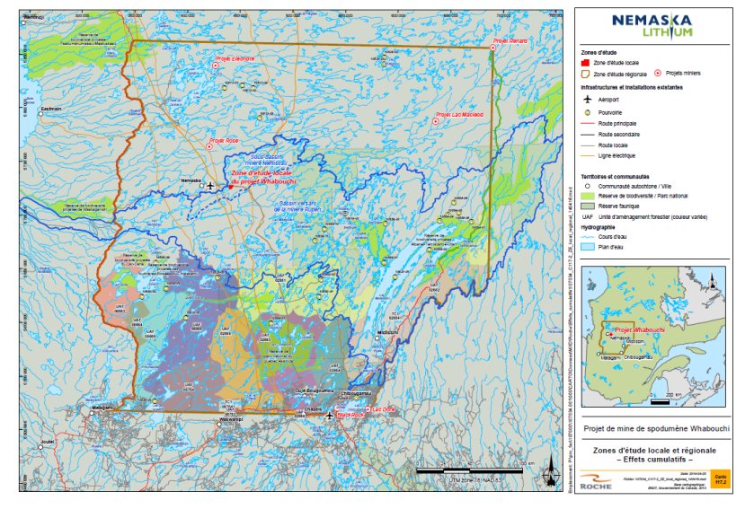
Source: Responses to questions and comments from the Agency, Nemaska Lithium, April 2014
|
Project, activity or event |
Past |
Present |
Future |
|---|---|---|---|
|
Small hydroelectric Projects |
|||
|
Eastmain-1 |
X |
- |
- |
|
Eastmain-1-A-Sarcelle-Rupert |
X |
X |
- |
|
Hydro-Québec power station and transmission lines |
X |
- |
- |
|
Opinaca reservoir |
X |
- |
- |
|
Transportation infrastructure |
|||
|
Nemiscau airport |
X |
- |
- |
|
Route du Nord |
X |
||
|
Route 167 Nord extension to Monts Otish |
- |
X |
X |
|
Resource development |
|||
|
Forestry operations |
X |
X |
X |
|
Mining exploration activities |
X |
X |
X |
|
Mining Projects |
|||
|
Troilus Mine |
X |
- |
- |
|
Renard Project |
- |
- |
X |
|
Lac Macleod Project |
- |
- |
X |
|
Rose Project |
- |
- |
X |
|
Éléonore Project |
- |
- |
X |
|
BlackRock Project |
- |
- |
X |
|
Wildlife/protected areas |
|||
|
Outfitters |
X |
X |
X |
|
Wildlife reserves |
X |
X |
X |
|
Protected areas |
X |
X |
X |
|
Biodiversity reserves |
- |
- |
X |
|
Albanel-Témiscamie-Otish National Park Project and Assinica National Park Reserve |
- |
X |
X |
|
Other |
|||
|
Forest fires |
X |
X |
X |
|
Woodland caribou recovery strategy 2005-2012 |
X |
- |
- |
|
Working group on Woodland caribou recovery |
X |
X |
X |
|
Société Weh-Sees Indohoun |
X |
X |
X |
According to the Proponent, the Eastmain-1 and Eastmain-1-A-Sarcelle-Rupert hydroelectric Projects played a role in the fragmentation of the regional Project study area. These power plants are located 88 kilometers north of Nemiscau and have an installed capacity of 507 megawatts and 768 megawatts, respectively. These large-scale hydroelectric projects included the construction of dams, roads, power stations, substations and power transmission lines, as well as a 735 Kilovolts line crossing the study area. The creation of the Opinaca reservoir, located approximately one hundred kilometers north of Nemaska to divert water from the Eastmain watershed to the Grande Rivière, has also contributed to altering the water regime of the regional study area.
According to the Proponent, transportation infrastructure, i.e., the Nemiscau airport, Route du Nord and the extension of road 167 Nord to Monts Otish, also contributed to altering the regional study area of the Project.
Six mining projects were considered in the Proponent's assessment of cumulative effects in the regional study area. The exploration and development phases of these projects are relatively advanced. Five mining projects are in the development or implementation stage. The Troilus mine Project is no longer in operation and the decommissioning of its infrastructure continued until 2012. These projects are located far from one another (see Figure 13).
According to the Proponent, various forest activities have taken place in the area since 1975, primarily in the south part of the regional study area.
The Proponent also took into account activities related to hunting, fishing and trapping, i.e., 12 outfitters, the Assinica and Lacs-Albanel-Mistissini-et-Waconichi wildlife reserves, and the management of activities in Cree territory by the Société Weh-Sees Indohoun. Other regional activities were considered, such as the woodland caribou recovery strategy and the woodland caribou recovery working group, which gave the Proponent a better understanding of the situation facing this species at risk and helped it propose concrete action. The Proponent's assessment of cumulative effects also takes into account the fact that the Whabouchi Project is located in a restricted Government of Quebec forest fire protection area. In the Nemaska sector, a total of 1 876 square kilometers of forest burned between 2004 and 2012, primarily caused by lightening.
According to the Proponent's assessment of cumulative effects, only local effects associated with the 735-kilovolt power transmission line and Route du Nord could have cumulative effects that could interact with effects from the Whabouchi Project. These cumulative effects could alter some of the valued components selected by the Proponent, such as air quality, noise environment, water resources, wetlands, and fish and fish habitat. The Proponent estimated that these cumulative effects were not significant.
8.4.2 Potential Cumulative Effects on Fish and Fish Habitat
The Proponent has analyzed the Project's cumulative effects on fish and fish habitat in light of the applicable regulations and concerns raised by the Cree Nation of Nemaska relating to the importance of the fish in their diet.
The key projects whose effects could interact cumulatively with the effects of the Whabouchi Project are a Hydro-Québec power transmission line and Route du Nord. Maintenance forest clear cuts at substations and around transmission lines has caused and will continue to cause water quality changes by bringing sediments into suspension and could contaminate the water through accidental leaks (hydrocarbons and heavy metals). They are also associated with permanent losses of fish habitat or changes in the use of fish habitat by fish. In addition to the above-mentioned effects, Route du Nord would also increase fishing pressure in the Whabouchi Project area by opening up access to the area.
The anticipated effects of the Whabouchi Project on fish and fish habitat are changes in water quality caused by contaminants (hydrocarbons, heavy metals, suspended solids, etc.) and serious harm to fish resulting from the combined effect of reduced surface water inflow and groundwater drawdown on certain water bodies and streams. For the most part, these effects would be limited to watersheds affected by the mine's activities.
The Proponent anticipates an undesired increase in fishing pressure despite its intention to prohibit fishing by mine employees at the mine site.
Apart from the mitigation and follow-up measures presented in Section 7.1, the Proponent has not proposed any other specific measures for limiting cumulative effects.
The Proponent provided few details about its assessment of the Project's cumulative effects on fish and fish habitat except to say that it considers the effect moderate and believes the only projects that could have effects that interact cumulatively with those of the Whabouchi Project are the Hydro-Québec power transmission line and Route du Nord. The Proponent did not consider fish habitat compensation in its analysis of the cumulative effects on this component. Fisheries and Oceans Canada has no additional concerns apart from those mentioned by the Proponent in connection with the cumulative effects on fish and fish habitat.
Agency Analysis and Conclusion
The Agency is of the view that the cumulative effect that the Whabouchi Project could have on effects caused to fish and fish habitat by other projects is low, primarily because the residual effect of the Whabouchi Project on fish and fish habitat in terms of encroachment is limited to the immediate Project area and involves small decreases in the area of certain lakes and streams. The magnitude of the residual effect is also low since serious harm to fish will be offset in accordance with the Fisheries Act.
The Agency is also of the view that the negative residual effects of the Whabouchi Project on increasing suspended solids in water that could combine with the water quality effects of Route du Nord and transmission line maintenance would be low given the implementation of the water quality mitigation and follow-up measures proposed by the Proponent.
Accordingly, the Agency finds that the Project is not likely to cause significant adverse cumulative effects on fish and fish habitat and considers that no additional mitigation or follow-up measures are necessary.
8.4.3 Potential Cumulative Effects on Migratory Birds
The Proponent analyzed the cumulative effects of the Project on waterfowl given its value to the Cree and the federal migratory bird's regulation. It also assessed the cumulative effects on two migratory bird species at risk: olive-sided flycatcher and common nighthawk. Section 8.3.5 contains the Proponent's analysis in this regard.
With respect to waterfowl, the Proponent is of the view that the effects of all of the projects listed in Table 9 are likely to combine with the effects of the Whabouchi Project given that these birds use large areas of land. The activities involved in these projects have or will cause changes in certain behaviors, such as feeding and reproduction, potential mortality in young birds and habitat losses, particularly in streams, lakes and wetlands due to the installation of infrastructure. For example, development of the Eastmain-1-A power station and diversion of the Rupert River flooded large areas of land and the flow of water in some streams was reduced or some streams were simply diverted.
Apart from the mitigation and follow-up measures set out in Section 7.2 for birds, the Proponent is not proposing any other specific measure to reduce cumulative effects.
The Proponent provided little explanation of how it assessed the Project's cumulative effects on waterfowl except to say that it considers the effect to be moderate taking into account the residual effects and that the footprint of the Whabouchi Project is quite small compared to several large-scale projects that have characterized development in the James Bay area and that may have affected waterfowl in the study area.
Agency Analysis and Conclusion
The Agency is of the view that the cumulative effect of the Whabouchi Project to the effects of other projects on migratory birds is low. This is primarily because the surrounding environment is relatively undisturbed by other projects or infrastructures and because the birds are able to relocate to similar habitats near the mine site.
The Agency therefore finds that the Project would not cause significant adverse cumulative effects on waterfowl or migratory birds in general, and finds that no additional mitigation or follow-up measures are necessary.
8.4.4 Potential Cumulative Effects on Aboriginal Peoples
Taking into account the results of air and water quality modellings, the Proponent is of the view that it is reasonable to conclude that the risk of contamination will be low and even insignificant. It therefore believes that the Project will have no impact on the quality of traditional food harvested in the vicinity of the mine site. For that reason, the Proponent did not include the cumulative effects of the Project on Aboriginal health in its assessment.
In Section 7.5 on Aboriginal health, the Agency found that the information provided by the Proponent was insufficient to conclude that the Project would have no effects on Aboriginal health. However, the Agency believes that the follow-up programs proposed by the Proponent will be able to detect any health issues, particularly the possibility of effects caused by atmospheric deposition of contaminants in water bodies used as drinking water sources. The Proponent has undertaken to take any necessary corrective actions if required. Given that the possible effects on Aboriginal health will be local in nature, and that other projects likely to affect Aboriginal health are located far from the Whabouchi Project, the Agency is of the view that the Whabouchi Project is not likely to result in cumulative effects with the effects of other projects. The Agency therefore did not require that an assessment of the cumulative effects on Aboriginal health be conducted.
The Proponent analyzed the cumulative effects of the Project on Aboriginal peoples primarily in light of concerns raised by the Cree Nation of Nemaska relating to hunting, fishing and trapping, and to their traditional way of life and cultural identity. To this end, the Proponent focused on the valued components of "hunting, fishing and trapping", "community well-being", "community infrastructure" and "socio-economic aspects". For the purposes of this report, the Agency discusses only the first two components analyzed by the Proponent in the following paragraphs, given that "community infrastructure" and "socio-economic aspect" components concern issues not covered by federal environmental assessments.
The Proponent considered the effects of all of the projects listed in Table 9 as being likely to combine with the effects of the Whabouchi Project on Aboriginal peoples, given that the traplines and use of the land in general cover vast expanses of territory.
Hunting, Fishing and Trapping
According to the Proponent, with the development of James Bay and the implementation of major hydroelectric projects, the users of the land have adapted their activities to this new environment. Parts of the territory that were once accessible and used became inaccessible and were therefore abandoned by users. For example, the drop in water levels in the Rupert River resulted in changes in how permanent camps on five traplines of the Cree Nation of Nemaska were used. Fishing activities on the Nemiscau River and Teilhard Lake changed. Overall, the Eastmain-1-A hydroelectric Project and the diversion of the Rupert River affected 36 traplines, including trapline R20, which is also affected by the Whabouchi Project. Figure 14: compares the study areas of the two projects.
Figure 14: Location of the Whabouchi Project Study Area in Relation to Natural Environment Study Area of the Eastmain-1-A-Sarcelle-Rupert Hydroelectric Project

Source: Responses to questions and comments from the Agency, Map Appendix, Roche, April 2014
Roads construction has opened up the territory, making it more accessible and possibly increasing pressure on wildlife harvesting. This is true of both Route du Nord, which runs along the site of the Whabouchi Project, and the Route 167 Nord extension to Monts Otish Project, which will affect seven traplines. According to the Proponent, the projects identified in the study area (Table 10) will not prevent hunting, fishing and trapping activities, but will change how they are carried out in the territory.
According to the Proponent, the recent destruction of potential terrestrial habitat for waterfowl and terrestrial wildlife species over most of the Whabouchi Project site by forest fires means that the Project's effects on this valued component are primarily limited to the local study area.
To minimize the potential cumulative effects on hunting, fishing and trapping, the Proponent would establish a monitoring and follow-up program to monitor use of the area and its resources, particularly potential changes caused by the Whabouchi and other projects. Accordingly, hunting, fishing and trapping activities by Cree and other users in the region of the Project will be documented in order to address the concerns raised by the Cree Nation of Nemaska.
Considering its distance from other past, present and future projects, activities or events, the Proponent is of the view that the Whabouchi Project would not compromise harvesting activities in the regional study area. Therefore, the Proponent considers the cumulative effect on this valued component to be of moderate significance.
Agency Analysis and Conclusion
The Agency is of the view that the Proponent conducted an accurate assessment of the potential cumulative effects of the Project on hunting, fishing and trapping and that it took Aboriginal concerns into account in its analysis. The Agency therefore concludes that the Project is not likely to cause significant adverse cumulative effects on hunting, fishing or trapping and that no additional mitigation or follow-up measures are necessary.
8.4.5 Potential Cumulative Effects on Species at Risks
Given the vulnerability of species at risk, the Federal Environmental Assessment Committee asked the Proponent to assess the cumulative effects on each species at risk likely to be affected by the Project, namely the little brown myotis, woodland caribou, olive-sided flycatcher, common nighthawk, rusty blackbird and short-eared owl. The Proponent did not perform an assessment for the Northern myotis, which was not designated a species at risk under the Species at Risk Act until after the environmental impact statement and additional information were submitted by the Proponent.
Little brown myotis
As mentioned in Section 8.1, a little brown myotis maternity colony comprising approximately 300 bats is located roughly 625 meters east of the mine site. The indicator used by the Proponent to measure the cumulative effect on the little brown myotis is a decline in the use or occupancy of the maternity colony. According to the Proponent's cumulative effects assessment, several other projects, activities and events in the regional study area (Table 9) have impacted or will impact little brown myotis habitats. Given that these projects are relatively far from the both Whabouchi Project and little brown myotis maternity colony and that a forest fire recently destroyed a large number of this species' potential habitats, the Proponent is of the view that it is unlikely that the cumulative effect on the little brown myotis will be significantly increased by the Whabouchi Project. According to the Proponent, the cumulative effect on this valued component will therefore be of moderate significance, primarily because of the species' status.
Views Expressed (bats)
The Agency is of the view that the anticipated effects on the little brown myotis could also affect the Northern myotis. Environment Canada indicated that the Proponent will have to take into account the recovery strategies developed for the little brown myotis and the Northern myotis when they become available on the Species at Risk Public Registry website in order to ensure that its Project meets the objectives of the recovery strategies and that it makes the appropriate corrective adjustments to its follow-up program or additional mitigation measures, as necessary.
Woodland caribou
The following three indicators were used to measure the cumulative effects on woodland caribou: habitat alteration/disturbance, diminished habitat quality and area of land affected.
Site clearing carried out as part of other projects mentioned in Table 9 has significantly disturbed caribou habitat over the years. For example, the construction of Route 167 Nord to Monts Otish required the clearing of 35.52 square kilometers of land, and the Eastmain?1?A power station and Rupert River diversion caused the loss of 95 square kilometers of high-potential winter caribou habitat. Logging and mining projects in the regional study area require the construction of roads, which further fragments the caribou's habitat and leads to movements of their predators. Forest fires also cause changes to the habitat of caribou, which prefer mature, relatively undisturbed coniferous forests.
With respect to the Whabouchi Project, the potential loss of woodland caribou habitat is relatively low at 0.16 square kilometer. The area covered by this project is rarely used by the woodland caribou and is located in the Weh Sees Indohoun sector, where sports' hunting of the caribou is prohibited.
Given that the woodland caribou could be affected by habitat loss and fragmentation and by disturbance, the Proponent considers the significance of cumulative effects on the woodland caribou to be moderate.
Views Expressed (woodland caribou)
As mentioned in Section 7.3, Environment Canada considers it unlikely for woodland caribou to occur in the study area given that the habitat in question does not have the characteristics required by this species and that the species makes little or no use of the sector.
According to the recovery strategy for the woodland caribou (Boreal population), many of the threats to this species and its habitat are related and may interact, in which case they can have cumulative effects that may look less significant when threats are examined individually. Additionally, cumulative effects related more specifically to the size and distribution of local caribou populations may have a lag effect, which can take years to manifest. Environment Canada is therefore of the view that it is important to remain vigilant and to look at the effects as a whole over a vast area.
According to Environment Canada, most of the projects or activities identified by the Proponent involve the construction of linear infrastructure, such as roads and hydroelectric lines. These contribute to habitat fragmentation (barrier effect of roads), increased risk of collision with vehicles, increased predation by wolves and poaching, which degrade the quality of caribou habitat and make the species more vulnerable. These effects should have been considered in the Proponent's cumulative effects assessment.
In fact, as a major survival strategy against predators, the caribou geographically isolates itself from predators and other prey, thus maintaining a low population density across its range. Therefore, local populations must have access to vast, undisturbed stretches of acceptable quality land to ensure their self-sufficiency.
Given the limited use of the study area by woodland caribou, Environment Canada considers that the monitoring and observation log suggested by the Proponent are good means of monitoring this species in the circumstances, particularly since the Proponent is using an adaptive management approach to take into account any issues observed in order to be able to take the necessary corrective actions as soon as possible. Environment Canada advises the Proponent to forward all information collected on woodland caribou to organizations responsible for its recovery, particularly the Quebec Government and Environment Canada.
Olive-sided flycatcher and common nighthawk
The main effects of other projects (Table 10) that could interact cumulatively with the effects of the Whabouchi Project on olive-sided flycatcher and common nighthawk concern habitat loss, primarily terrestrial and wetland environments and open environments, mortality of young birds, and changes in certain behaviors such as feeding and reproduction caused by disturbances resulting from site clearing and mine operation.
According to the Proponent, the cumulative effect on the olive-sided flycatcher and common nighthawk would be felt at the regional study area level. It considers the magnitude of the cumulative effect to be moderate given that the Whabouchi Project will result in a loss of habitat of interest to these species and its distance from other past, present or future projects, activities or events, relative to the site of the Whabouchi Mining Project.
Rusty blackbird and short-eared owl
The main effects of other projects (Table 9) that could combine with the effects of the Whabouchi Project on the rusty blackbird and the short-eared owl concern habitat loss, primarily wetlands and large bogs, mortality of young birds, and changes in certain behaviors, such as feeding and reproduction caused by the disturbance resulting from site clearing and mine operation.
According to the Proponent, the cumulative effect on rusty blackbird and short-eared owl would be felt at the regional study area level. It considers the magnitude of the cumulative effect as low, for these two species, given that the Whabouchi Project will not generate any significant loss of wetlands of interest to these species, given their distance from other past, present or future projects, activities or events relative to the site of the Whabouchi Mining Project. The Proponent has also undertaken to offset any unanticipated wetland loss revealed by its follow-up program. The Proponent did not submit specific mitigation or follow-up measures for species at risk other than those described in Section 7.3.
Views expressed (birds at risk)
Given the uncertainty surrounding the reasons for the decline in bird species at risk, Environment Canada is of the view that any additional losses or changes in habitat will affect those species. It believes that the activities of the Whabouchi Mining Project and other past, present and future projects, actions and events identified by the Proponent could have cumulative effects on the species' breeding habitat (habitat alteration and loss) and nesting activities (disturbance caused by the presence of the mine and mining activities). Therefore, although habitats are abundant in the vicinity or the Projet site, the cumulative adverse residual effects could reduce the availability of high-quality habitats for species at risk and also increase intra and inter-specific competition in these species. In Environment Canada's opinion, a follow-up program for species at risk could, to some extent, alleviate the uncertainty surrounding the adverse residual and cumulative effects of the mine Project on the four bird species at risk.
Agency Conclusion
The Agency is of the view that the cumulative effects assessment for the Whabouchi Project determined that all species at risk considered within the framework of the Project could be affected by habitat loss and fragmentation and by disturbance from other projects in the study area. However, the Agency concludes that the adverse cumulative effects would not be significant considering the availability of similar habitat nearby and the implementation of the mitigation measures proposed by the Proponent (Appendix A). The Agency recommends that the Proponent keep an eye out for the release of any new recovery strategy for species at risk likely to be affected by the Project. The Proponent should ensure that it meets the recovery strategy objectives, makes corrective adjustments to its follow-up programs or implements additional mitigation measures, if necessary.
9 Impacts on Potential or Established Aboriginal or Treaty Rights
9.1 Impacts on Potential or Established Aboriginal or Treaty Rights in the Project Area
The Project is located on Cree land as defined in the James Bay and Northern Quebec Agreement (the Agreement), an Aboriginal treaty protected by section 35 of the Constitution Act, 1982. The Agreement provides for a territorial regime that divides the land into three categories. The Whabouchi Project is located on Category III lands, which are Quebec government lands on which Aboriginal and non-Aboriginal people may hunt and fish. Aboriginal users nevertheless have exclusive rights to harvest certain aquatic species and furbearing animals[8] and participate in administering and developing the land.
The rights and guarantees granted to the Cree under the hunting, fishing and trapping regime in force on Category III lands are governed by Chapter 24 of the Agreement. This regime includes the traditional land use system and the current uses of Cree traplines. Each trapline is the responsibility of a Cree tallyman who belongs to one of the nine Cree communities.
The Project is located on trapline R20, associated with the Cree Nation of Nemaska. The Cree tallyman and approximately 40 local Cree use the area for hunting, fishing and trapping. It includes permanent and temporary camps.
9.2 Potential Adverse Impacts of the Project on Potential or Established Aboriginal or Treaty Rights
The Cree have hunting, fishing and trapping rights. Section 7.3 provides a detailed explanation of the Project's potential effects on the rights of the Nemaska Cree in the context of current land and resource uses for traditional purposes. The impact on rights would relate to:
- The loss of hunting, fishing and trapping land covering slightly more than 9 square kilometers (mine infrastructure and safety zone) as well as the inability to erect hunting camps, to move around or to harvest resources in the area using current and traditional methods (including firearms);
- A reduction in wildlife populations and degradation of the quality of animal meat along with disturbance of hunting camps in sectors adjacent to the mine infrastructure and safety zone.
This impact would occur in the southwest part of trapline R20. No effects are expected on other traplines.
9.3 Proposed Accommodation Measures
The Proponent is working together with the Nemaska Cree and federal and provincial authorities to develop mitigation measures that also serve as accommodation measures. The aim of these measures is to minimize or avoid potential adverse impacts on rights under the Agreement.
In response to concerns about the protection of hunting, fishing and trapping, the Proponent reviewed the mine site layout to relocate infrastructure away from the Lac des Montagnes. The waste rock and tailings pile would be developed to the north of Route du Nord. The settling ponds and overburden pile have also been relocated more than 750 meters from the Lac des Montagnes. As a result of these measures, the Project has been moved away from valued geese and waterfowl hunting sites and from trapping and fishing areas. In addition to this change, the Proponent has provided for measures to mitigate the Project's effects on wildlife species and on the quality of their meat. These measures are described in Sections 7.4 and 7.5.
The Proponent is working with Fisheries and Oceans Canada to develop a compensation plan that would offset any serious harm to fish resulting from the implementation of the Project.
According to a news release from Nemaska Lithium dated November 7, 2014, the Proponent, the Grand Council of the Crees (Eeyou Istchee), the Cree Nation Government and the Cree Nation of Nemaska engaged in discussions about the development and operation of the Whabouchi Project. Those discussions covered, among others, training, employment and business opportunities for the Cree during the construction, operation and closure of the mine and articulated the principles of social, cultural and environmental respect that will be applied in the management of the Project. In addition, discussions covered a mechanism that will enable the Cree to benefit financially from the long-term economic spinoffs of the Project was put.
9.4 Issues to be addressed during the Regulatory Approval Phase
For the Proponent, the regulatory approval phase of the Project consists of obtaining federal authorizations, licenses and approvals. For the Whabouchi Project, the only authorization anticipated is a Fisheries Act authorization. Depending on the decision by the Minister of the Environment, Fisheries and Oceans Canada could issue an authorization under the Fisheries Act conditional clauses in the implementation of the following elements:
- The mitigation measures required to avoid and reduce serious harm to fish;
- A compensation plan to offset serious harm to fish;
- A follow-up program to monitor the Project's effects on fish and fish habitat.
9.5 Outstanding Items
The measure proposed by the Proponent to prohibit all hunting, fishing or trapping on the mine property partially addresses the issue of the pressure by workers on wildlife resources. Since hunting, fishing and trapping are regulated by the Government of Quebec, the Agency recommends that the Cree Nation of Nemaska refer to the province to discuss the mechanisms required to resolve this issue. The Proponent has informed the Quebec government of this concern.
Measures proposed by the Proponent to reduce the effects of increased traffic on Route du Nord do not entirely address the concerns of the Cree Nation of Nemaska regarding dust and noise caused by traffic. This issue is outside the scope of the federal environmental assessment, but the Agency has transmitted the concern to the Proponent.
The Cree Nation of Nemaska remains concerned about the rehabilitation of the mine site since many industrial sites have been abandoned, with waste left behind (barrels, propane tanks and metal structures) on the land. The Quebec Mining Act contains provisions to ensure the restoration of land affected by mining activities. Under the Mining Act, the Proponent is required to submit a rehabilitation plan and financial guarantee to the Government of Quebec.
9.6 Agency Conclusion Regarding Impacts on Aboriginal Rights
The Agency is satisfied that the potential impacts of the Project on rights established under the James Bay and Northern Quebec Agreement have been adequately identified. The Proponent's mitigation measures, the conditions recommended to the Minister of the Environment and the possible conditions tied to federal licenses could mitigate and accommodate impacts on these rights.
10 Conclusions and Recommendations of the Agency
To conclude on the matter of the Project's significant adverse environmental effects and to define the key mitigation measures and follow-ups that the Proponent will have to implement, the Agency has taken into account the Proponent's environmental impact statement, technical reports and complementary information documents, as well as comments received from the public, Aboriginal groups, government organizations and the Cree Nation Government. The Agency received comments from the federal authorities on the draft of this environmental assessment report. Appendix E: provides a summary of comments and concerns submitted by the Cree Nation of Nemaska and responses provided by the Agency and the Proponent.
The environmental effects of the Project have been determined using assessment methods and analytical tools that reflect current best practices of environmental and socio-economic assessment practitioners, including the consideration of cumulative effects and potential accidents or malfunctions.
The Agency concludes that the Whabouchi Mining Project would not likely cause significant adverse environmental effects, taking into account the implementation of the key mitigation measures and follow-up programs described in this environmental assessment report (see Appendix G).
The Agency has identified the key mitigation measures and follow-up program requirements to be recommended to the Minister of the Environment (the Minister) for consideration in deciding whether the Project is likely to cause significant adverse environmental effects. If the Minister concludes that the Project is not likely to cause significant adverse environmental effects as defined in section 5 of the CEAA 2012, the Minister will establish conditions as part of the decision statement issued to the Proponent.
11 References
Canadian Environmental Assessment Agency. Addressing Cumulative Environmental Effects under the Canadian Environmental Assessment Act. Operational Policy Statement. November 2007.
www.canada.ca/en/environmental-assessment-agency/services/policy-guidance.html
Canadian Environmental Assessment Agency. Addressing "Need for," "Purpose of," "Alternative to" and "Alternative Means" under the Canadian Environmental Assessment Act. November 2007.
www.canada.ca/en/environmental-assessment-agency/services/policy-guidance.html
Canadian Environmental Assessment Agency. Cumulative Effects Assessment Practitioners' Guide. 1999. 83 p. + appendices. www.canada.ca/en/environmental-assessment-agency/services/policy-guidance/cumulative-effects-assessment-practitioners-guide-2-0-assessment-fundamentals.html
Canadian Environmental Assessment Agency. Operational Policy Statement – Assessing Cumulative Environmental Effects under the Canadian Environmental Assessment Act, 2012, 10 p. www.canada.ca/en/environmental-assessment-agency/services/policy-guidance.html
CANADIAN ENVIRONMENTAL ASSESSMENT AGENCY. Whabouchi Mining Project, Near Nemiscau and 289 km north of Chibougamau, Quebec. Environmental Impact Statement Guidelines. March 18, 2013. 49 p.
ARCHEO-08. Étude du potentiel archéologique: Nemaska exploration, projet Whabouchi. Report submitted to Geodefor-Envirocri ltée, Rouyn-Noranda, December 2011. 35 pages. In French only.
ARCHEO-08. Inventaire archéologique Projet Whabouchi Juillet 2012. Completed on behalf of Nemaska Lithium. September 2012. 60 pages + appendix. In French only.
BOTALYS. Associations végétales et inventaire floristique-Projet Whabouchi. Document submitted to Nemaska Lithium. July 2012. 22 pages + appendices.
GROUPE QUALITAS INC. Complementary hydrogeological characterization. Whabouchi Project, Nemaska. September 19, 2012. 10 pages + appendices.
GOLDER ASSOC.Results of the Water Balance and Water Quality Models for the Whabouchi Lithium Mine. Report submitted to Nemaska Lithium. June 21, 2013. 47 p. + appendices.
GOVERNMENT OF CANADA. Species at Risk Act.
GOVERNMENT OF CANADA. Migratory Birds Convention Act, 1994.
GOVERNMENT OF CANADA. Metal Mining Effluent Regulations.
JOURNEAUX ASSOC. Site drainage, water balance, material quantities required for construction of drainage structures, stability of the reject pile and sedimentation basins dikes. Feasibility Study.Whabouchi Mine. Nemaska, Québec. Report no L-11-1452-1. June 2012. 27 p. + appendices.
LAMONT INC. Geochemical Characterisation of Waste Rock, Ore and Tailings Whabouchi Project James Bay Area, Quebec, Canada. March 2013. 21 p. + appendices.
MINISTÈRE DU DÉVELOPPEMENT DURABLE, DE L'ENVIRONNEMENT, DE LA FAUNE ET DES PARCS. 2010. Update on Air Activities, Direction du suivi de l'état de l'environnement.
NEMASKA LITHIUM. Whabouchi Project.Development and Operation of a Spodumene Deposit in the James Bay Territory.Environmental and Social Impact Assessment. Main Report. March 2013. Pagination by section and Appendices.
NEMASKA LITHIUM. Whabouchi Project.Development and Operation of a Spodumene Deposit in the James Bay Territory.Environmental and Social Impact Assessment. Summary. May 2013. 65 p.
NEMASKA LITHIUM. Whabouchi Project.Development and Operation of a Spodumene Deposit in the James Bay Territory.Environmental and Social Impact Assessment. Additional Information. May 2013.
NEMASKA LITHIUM. Whabouchi Project.Development and Operation of a Spodumene Deposit in the James Bay Territory.Environmental and Social Impact Assessment. Additional Reports (in response to a request on May 23, 2013). June 2013.
NEMASKA LITHIUM. Whabouchi Project.Development and Operation of a Spodumene Deposit in the James Bay Territory.Environmental and Social Impact Assessment. Additional information requested by the Canadian Environmental Assessment Agency (CEEA). September 2013. 127 p. + appendices. In French only.
Rudolph, T. D., P. Drapeau, M.-H. St-Laurent AND L. Imbeau, 2012. Situation du caribou forestier (Rangifer tarandus caribou) sur le territoire de la Baie James dans la région Nord?du?Québec. Scientific report submitted to the Quebec Department of Natural Resources and Wildlife and to the Grand Council of the Crees (Eeyou Istchee).Montreal.Quebec. 77 p.
WESA ENVIR-EAU. Étude hydrogéologique. Projet Whabouchi Nemaska Lithium. Prepared for Nemaska Lithium. April 27, 2012. 33 p. In French only.
12 Appendices
Appendix A: Summary of the Mitigation Measures Proposed by the Proponent
This appendix contains mitigation measures proposed by the Proponent for valued components of the Environmental Impact Statement (EIS) identified by the Agency in evaluating the environmental effects of the Whabouchi Project. The measures are commitments undertaken by the Proponent at various stages of the environmental assessment process and come from different sources. Furthermore, the Proponent could implement additional mitigation measures, including measures that could be prescribed in connection with the authorization required to conduct the Project, issued by the federal government. Certain mitigation measures could be applicable to more than one valued component and are not repeated in the table.
|
Mitigation measures proposed by the Proponent based on valued components of the EIS |
Project phase |
|---|---|
|
Air quality |
|
|
|
|
|
|
|
|
Noise Environment |
|
|
|
|
Water Quality and Quantity - Hydrogeology and Groundwater Quality |
|
|
|
|
|
|
Hydrology |
|
|
|
|
|
|
Quality of Surface Water and Sediment |
|
|
|
|
|
|
|
|
|
|
|
|
Terrestrial Vegetation |
|
|
|
|
|
|
Wetlands |
|
|
|
|
Fish and Fish Habitat - Site preparation and development |
|
|
|
|
Use and Maintenance of machinery, road traffic and storage of hazardous materials and fuel |
|
|
|
|
Water Management |
|
|
|
|
|
|
|
|
|
|
|
|
Pit and Mine Operations, Ore Handling and Storage |
|
|
|
|
Mammals |
|
|
|
|
|
|
Avian wildlife |
|
|
|
|
|
|
|
|
|
|
Land and Resource Use |
|
|
|
|
|
|
|
|
|
|
|
|
|
|
|
|
|
|
Community Well-Being |
|
|
|
|
|
|
|
|
Cultural and Archeological Heritage (no artefacts were identified during the archeological inventories) |
|
|
|
|
Landscape |
|
|
|
|
|
|
|
|
|
Appendix B: Residual Effect Assessment Criteria Used for Each Valued Component
|
Evaluation Criteria |
Degree of Residual Effect |
||
|---|---|---|---|
|
Magnitude of impact |
Low |
Medium |
High |
|
The relative importance of consequences (negative or positive) resulting from a change/alteration in a project activity on the structure or function of a valued component. |
The effect changes the quality, use or integrity of the component very little |
The effect changes the level of quality of the component or its use without necessarily compromising its environmental integrity |
The effect compromises the integrity of the component or significantly changes its quality or use |
|
Geographic extent of impact |
Site-specific |
Local |
Regional |
|
Refers to the spatial scale or number of persons affected. |
The effect is felt over a limited, clearly delineated area or by a small percentage of the population in the study area. |
The effect is felt over an area larger than the Project's footprint or by a limited portion of the population in the study area. |
The effect is felt throughout the study area or by a majority of the population in the study area. |
|
Duration of effect |
Short |
Medium |
Long |
|
Refers to the length of time for which the effects of the activity will affect the valued component. |
The effect is considered short-lasting when the effects are perceived continuously or intermittently during construction or closure of the mine site. |
The effect is considered moderate when the effects are perceived continuously or intermittently for the entire duration of the Project (from construction to closure), during the operation period or during construction and closure periods. |
The effect is considered long-lasting when it is perceptible continuously or intermittently, beyond the closing period. |
|
Reversibility / Irreversibility |
Low |
Medium |
High |
|
The probability that a valued component cannot revert to its original condition (before the environmental effect) during the Project's life cycle. |
The effect is completely reversible. |
The effect is partially reversible. |
The effect is irreversible. |
Appendix C: Residual Effect on Valued Components – Significance Determination Grid
|
Magnitude |
Extent |
Duration |
Reversibility/Irreversibility |
Significance |
|---|---|---|---|---|
|
* Only residual impacts with very high and high significance have a significant effect within the meaning of the Canadian Environmental Assessment Act 2012. |
||||
|
High |
Regional |
Long |
High |
Very high |
|
Medium |
Very high |
|||
|
Low |
High |
|||
|
Medium |
High |
Very high |
||
|
Medium |
Very high |
|||
|
Low |
High |
|||
|
Short |
High |
High |
||
|
Medium |
High |
|||
|
Low |
High |
|||
|
Local |
Long |
High |
High |
|
|
Medium |
High |
|||
|
Low |
High |
|||
|
Medium |
High |
High |
||
|
Medium |
High |
|||
|
Low |
Medium |
|||
|
Short |
High |
High |
||
|
Medium |
High |
|||
|
Low |
Medium |
|||
|
Site-specific |
Long |
High |
High |
|
|
Medium |
High |
|||
|
Low |
Medium |
|||
|
Medium |
High |
High |
||
|
Medium |
Medium |
|||
|
Low |
Medium |
|||
|
Short |
High |
High |
||
|
Medium |
Medium |
|||
|
Low |
Medium |
|||
|
Medium |
Regional |
Long |
High |
High |
|
Medium |
Medium |
|||
|
Low |
Medium |
|||
|
Medium |
High |
High |
||
|
Medium |
Medium |
|||
|
Low |
Medium |
|||
|
Short |
High |
Medium |
||
|
Medium |
Medium |
|||
|
Low |
Medium |
|||
|
Local |
Long |
High |
Medium |
|
|
Medium |
Medium |
|||
|
Low |
Medium |
|||
|
Medium |
High |
Medium |
||
|
Medium |
Medium |
|||
|
Low |
Medium |
|||
|
Short |
High |
Medium |
||
|
Medium |
Medium |
|||
|
Low |
Low |
|||
|
Site-specific |
Long |
High |
Medium |
|
|
Medium |
Medium |
|||
|
Low |
Low |
|||
|
Medium |
High |
Medium |
||
|
Medium |
Medium |
|||
|
Low |
Low |
|||
|
Short |
High |
Medium |
||
|
Medium |
Low |
|||
|
Low |
Low |
|||
|
Low |
Regional |
Long |
High |
Medium |
|
Medium |
Low |
|||
|
Low |
Low |
|||
|
Medium |
High |
Medium |
||
|
Medium |
Low |
|||
|
Low |
Low |
|||
|
Short |
High |
Medium |
||
|
Medium |
Low |
|||
|
Low |
Low |
|||
|
Local |
Long |
High |
Low |
|
|
Medium |
Low |
|||
|
Low |
Low |
|||
|
Medium |
High |
Low |
||
|
Medium |
Low |
|||
|
Low |
Very Low |
|||
|
Short |
High |
Low |
||
|
Medium |
Very Low |
|||
|
Low |
Very Low |
|||
|
Site-specific |
Long |
High |
Low |
|
|
Medium |
Low |
|||
|
Low |
Very Low |
|||
|
Medium |
High |
Low |
||
|
Medium |
Very Low |
|||
|
Low |
Very Low |
|||
|
Short |
High |
Low |
||
|
Medium |
Very Low |
|||
|
Low |
Very Low |
|||
Appendix D: Summary of Alternatives and Options Chosen by the Proponent
|
Activity / Alternatives |
Criteria |
Comment |
|---|---|---|
|
↑: increase ↓: decrease |
||
|
Mining |
||
|
Operation of an open pit followed by underground mining (chosen option) |
Technical |
The geology of the deposit is that of an elongated mineralized body. It runs flush with the surface |
|
Environmental |
Environmental and social impacts greater than underground mining (↑ dust, ↑ noise, ↑ ambient light, larger footprint, more intense surface traffic by heavy machinery) |
|
|
Economic |
Higher restoration costs Cost effective |
|
|
Social |
More significant alteration of the current landscape than an underground mine |
|
|
Underground only |
Technical |
More complex engineering (support, ventilation, surface pillars) |
|
Environmental |
More limited environmental impacts than an open pit operation (reduction of Project's footprint, reduction of surface level waste rock). However, noise impact associated with the ventilation system for underground infrastructure if not properly designed. |
|
|
Economic |
Higher capital costs Higher operating costs Ore extraction by underground means would result in a significant loss of surface-level ore and deep-level ore and would not be cost effective |
|
|
Social |
Less extensive social impact than an open pit mine (more limited visual impact, less impact on quality of life, i.e., noise, dust, etc.) |
|
|
Waste rock disposal |
||
|
Return to pit followed by flooding |
Technical |
Temporary pile (operating period) ↑risk of accidents from dual handling of waste rock Platform to be built at edge of pit for truck loading Longer restoration at end of operations The whole of the waste rock could not be returned to the pit because of bulking; a stockpile will remain |
|
Environmental |
Flooding of the pit is beneficial where waste rock generates acid (not the case here) Greater use of trucks (greenhouse gas emissions), more dust and more noise Suspended solids in the pit water and potential impacts following spillover or transfer of waste rock Change in habitat of the remaining rock pile |
|
|
Economic |
Higher restoration costs (pit backfilling and remaining waste rock pile) Not economically viable |
|
|
Social |
Job creation (trucking) Access to the land delayed at end of operations No gradual restoration during work; impact on landscape during construction of the pile and during movement of waste rock at end |
|
|
Storage in permanent waste rock pile (chosen option) |
Technical |
Permanent pile Gradual restoration and shorter period of work at end of operation |
|
Environmental |
Larger footprint Less impact in terms of the duration of activities given the possibility of gradual restoration of the pile to mitigate the impact on the landscape Permanent impacts on the hydrological regime Change in type of vegetation on the pile compared to initial conditions |
|
|
Economic |
Higher operating costs because of gradual restoration but overall lower restoration costs |
|
|
Social |
Permanent impact on landscape at end of activities Shorter duration of activities hence less noise and fewer air emissions associated with heavy machinery (a few years less) |
|
|
Tailingsdisposal |
||
|
Paste tailings option |
Technical |
Risk of accidents (dike or pipe failure) Complexity of construction or operation (tailings site, dikes and water management) ↑ complexity of restoration work (dike and flooded areas) |
|
Environmental |
↑ tailings dust, ↑ footprint, impact on soil quality due to exfiltration of process water into soil Potential impact on groundwater quality due to seepage of process water into soil Disturbance of the hydrologic regime due to presence of a tailings site Potential impact on surface water quality following dike failure Greater loss of vegetation due to tailings Large volume of process water through tailings Greater loss of habitat due to presence of a tailings site, larger footprint because of the need for a separate waste rock pile as well |
|
|
Economic |
Higher restoration costs |
|
|
Social |
Visual impact of the tailings site and waste rock pile Greater loss of land given the need for a waste rock pile |
|
|
Co-disposal of filtered tailings option (chosen option) |
Technical |
Cannot be pumped No need to build dikes to contain tailings (page 2-56 of responses dated May 9, 2014) No water build-up at tailings site |
|
Environmental |
↑noise (truck transport to pile) Very little process water in tailings; water is reused by processing plant, therefore less need for outside water Higher rate of reactant reuse in process and thus less input Potential contamination by percolation of water from tailings site, but lower risk with only rain water to consider Allows for progressive restoration |
|
|
Economic |
Higher capital costs given that filtered tailings require additional infrastructure Higher operating costs given that filtered tailings require additional infrastructure More costly but option chosen for environmental and social reasons |
|
|
Social |
Less of a visual impact due to progressive restoration of the pile during operations |
|
|
Power supply |
||
|
Diesel generators |
Technical |
Known and proven solution Use of 5 diesel generators, each 2 MW Suited to remote regions without existing hydroelectric service Decontamination potentially necessary for site restoration |
|
Environmental |
Production of greenhouse gas emissions ↑ noise Risk of spills with road transportation of hydrocarbons, which could require soil, surface water and groundwater decontamination |
|
|
Economic |
Higher operating costs |
|
|
Social |
Negative perception of burning diesel to produce electricity when hydroelectric infrastructure exist nearby |
|
|
Hydroelectricity |
Technical |
On-site transformer required for electrical distribution. A distribution system must be created on site. Connection to Albanel station. Technically less safe to power equipment at bottom of pit No alternative in the event of an electrical power outage Dismantling of the overhead line at the mine site on closure of the mine |
|
Environmental |
Limited loss of vegetation with electric power line installation Potential disturbance of habitat |
|
|
Economic |
Higher capital costs Higher restoration costs given the need to dismantle the transmission line |
|
|
Social |
Potential disruption on Route du Nord and along its shoulder during power line construction Jobs related to power line construction 20 km disturbance of landscape Potential delivery of electricity to camps located along the edge of the mine property |
|
|
Generator/hydroelectricity combination (chosen option) |
Technical |
On-site transformer required for electrical distribution. A distribution system must be created on site. Connection to Albanel station. Back-up in the event of a failure of the hydroelectric system Provides a safer way to power equipment at the bottom of the pit (using generators) Dismantling of the overhead line at the mine site on closure of the mine Decontamination may be necessary during site restoration. |
|
Environmental |
GHG emissions and airborne contaminants but less than with the use of diesel generators alone ↑ noise levels but less than with the use of diesel generators alone Potential impacts on soil quality, and surface and groundwater quality in the event of a hydrocarbon spill Potential disturbance of habitat Lower risk of spills due to the transportation of less diesel by road, i.e., only enough to power generators at the bottom of the pit |
|
|
Economic |
Less costly and safer to operate mining equipment in the pit using diesel generators Higher restoration costs given the need to dismantle the power line and possible decontamination due to the use of diesel |
|
|
Social |
Potential disruption on Route du Nord and along its shoulder during construction of the power line Jobs related to power line construction 20 km disruption of landscape Negative perception of burning diesel to produce electricity when hydroelectric infrastructure exist nearby Potential delivery of electricity to camps located along the edge of the mine property |
|
|
Waste management |
||
|
Mine site management |
Technical |
Involves construction and management of a new infrastructure Known and proven solution Involves ↑ restoration work |
|
Environmental |
↑ Project footprint, potential impact on soil quality Risk of groundwater contamination, impact on water balance due to landfill site, impact on surface water quality Loss of vegetation due to ↑ Project footprint Potential loss of wildlife habitat due to ↑ Project footprint, may attract harmful wildlife species (ex: bears) |
|
|
Economic |
Higher capital costs Higher restoration costs No trucking costs |
|
|
Social |
Perceived potential health risk with the presence of an engineered landfill site Potential impact during construction of engineered landfill on cultural and archaeological heritage Change in landscape with the addition of engineered landfill site Addition to new infrastructure to the community's territory |
|
|
Nemaska community landfill (chosen option) approximately 20 km away |
Technical |
Reduce on-site management ↑ traffic on Route du Nord Known and proven solution |
|
Environmental |
Does not increase Project's footprint at the site Impact on air quality due to traffic on Route du Nord to engineered landfill site and GHG emissions More noise (trucking) Possibility of collisions with wildlife during travel between the mine site and Nemaska |
|
|
Economic |
Use of a nearby, existing infrastructure (20 km) |
|
|
Social |
↑ waste materials in the Nemaska engineered landfill Involves the Nemaska community, trucking jobs |
|
|
Engineered landfill site in Chibougamau, approximately 300 km away |
Technical |
↑ traffic on Route du Nord Known and proven solution |
|
Environmental |
Does not increase Project's footprint at the site Impact on air quality: ↑ GHG, ↑ dust,↑ noise from truck traffic Possibility of collisions with wildlife during travel between the mine site and Chibougamau |
|
|
Economic |
Higher operating costs (high trucking costs – 300 km) |
|
|
Social |
↑ waste materials in the Chibougamau engineered landfill Trucking jobs Use of infrastructure existing outside of the community |
|
|
Water Supply |
||
|
Surface water (from the Lac du Spodumène) |
Technical |
Requires a water intake with a long pipe to bring water to the processing plant and an adjacent road (access, maintenance and monitoring) Accident risk due to ↑ risk of frozen pipes Complexity of construction and operation since water intake would be constructed to have ↓ potential impact on fish and fish habitat |
|
Environmental |
Soil disturbance due to Project's ↑ footprint resulting from access road that will have to be built to the Lac du Spodumène Minor disruption of water natural balance naturel in the Lac du Spodumène Loss of vegetation due to construction of the access road to the Lac du Spodumène and a conduit Encroachment on fish habitat and potential fish mortality at water intake Potential loss of wildlife habitat due to the Lac du Spodumène access road |
|
|
Economic |
Higher capital costs, operating costs and restoration costs due to more extensive maintenance than required by a well |
|
|
Social |
Limited access to a portion of the Lac du Spodumène because of water intake Impact on landscape: water intake in lake would be visible; presence of access road |
|
|
Groundwater (well) (chosen option) |
Technical |
Requires pumping station and tank inside processing plant (760 000 L) Installation is possible directly near the processing plant |
|
Environmental |
Local dewatering of aquifer from water pumping by well Smaller footprint |
|
|
Economic |
Lower costs |
|
|
Social |
Not considered |
|
|
Worker accommodation |
||
|
Mine site housing complex |
Technical |
Construction and maintenance of a housing complex at the mine site |
|
Environmental |
Additional lighting at the mine site for the housing complex ↑ Project footprint due to the housing complex Additional need for water for the housing complex Change in the water balance due to construction of the housing complex Potential impact of household waste water effluent discharge Loss of habitat (terrestrial vegetation and wetlands, for wildlife) given the Project's ↑ footprint ↑ potential fishing around the housing complex |
|
|
Economic |
More costly due to higher capital and restoration costs |
|
|
Social |
↑ potential pressure on wildlife resource harvesting Possible random discovery of archaeological or cultural artefacts Addition of man-made infrastructure to the existing landscape |
|
|
Site transit system (chosen option) |
Technical |
↑ risk of accidents from bus traffic on Route du Nord |
|
Environmental |
↑ dust and noise due to bus traffic Environment already disturbed |
|
|
Economic |
Comparable operating costs but capital and restoration costs non existent |
|
|
Social |
Job creation within Cree community Use of existing infrastructure |
|
|
Location of piles and final effluent |
||
|
Option 1 variation considered in the preliminary economic study |
Technical |
A short section of Route du Nord will have to be redirected Construction in several phases will ensure gradual restoration of the pile during operations Will not affect Hydro-Québec power transmission line Storage of explosives near mine water pond dikes Multi-phase construction enables gradual restoration of the pile Two mine effluent discharge (Stream C and Lac des Montagnes), more complex water management |
|
Environmental |
Impact on streams C, E and F, loss of a portion of Stream F and dry out of Lake 29 Loss of terrestrial vegetation and wetlands Wildlife habitat loss |
|
|
Economic |
Higher capital and operating costs due to more complex management of water and two mine effluents Costs of moving part of Route du Nord (but only after 10 years of operation) |
|
|
Social |
During consultations, the Cree community of Nemaska expressed dissatisfaction with the Proponent's choice of this option. The community had concerns about the potential effects of the pile's proximity on water quality and wildlife habitats in the Lac des Montagnes and its bays. Some members of the community were concerned about the visual impact of the pile. Lac des Montagnes is known as a traditional hunting and fishing sector. |
|
|
Option 2 variation considered in the feasibility study (chosen option) |
Technical |
Mining effluent Avoids the need to diver Route du Nord |
|
Environmental |
No encroachment on streams or rivers in the region. Significantly reduced hydrological impact. Only one mining effluent in the Lac des Montagnes Avoids the loss of wetlands Project footprint smaller |
|
|
Economic |
Not considered |
|
|
Social |
Infrastructure farther away from the Lac des Montagnes making them less visible |
|
|
Location of finaleffluent discharge |
||
|
Nemiscau River – A variation considered in the draft economic study |
Technical |
Risk of accident due to risk that the pump conduit would freeze in winter The most complex solution given the distance and need to build and access road; would require pumping effluents to the Nemiscau River ↑ of footprint to restore at end of operations Strong flow ensures good mixing |
|
Environmental |
Noise associated with pumping system Impact on soil given the length of the pumping conduit to run to the Nemiscau River and requiring construction of an access road Positive dilution potential; potential for physical-chemical change in surface water quality Loss of terrestrial vegetation and wetlands due to the installation of a pumping conduit and access road Loss of potential fish habitat and potential change of fish community patterns Potential loss of wildlife habitat resulting from installation of pumping conduit and access road |
|
|
Economic |
Highest capital, operation and restoration costs |
|
|
Social |
Location highly valued by the Cree community, effluent discharge point would be located upstream from Cree camps |
|
|
Lac du Spodumène – A variation considered in the preliminary economic study. |
Technical |
Risk of accidents caused by potential freezing of the pump pipe in winter Requires pumping effluent to the Lac du Spodumène ↑ of footprint to restore at end of operations |
|
Environmental |
Noise associated with pumping system Impact on soil with the installation of a pumping conduit to the Lac du Spodumène and requiring the construction of an access road Potential change in physical-chemical quality of surface water Loss of terrestrial vegetation and wetlands due to installation of the pumping conduit and access road Loss of potential habitat and potential change of fish community dynamics Potential loss of wildlife habitat resulting from installation of pumping conduit and access road |
|
|
Economic |
Not considered |
|
|
Social |
A location valued and used by area users Possibility of a random discovery of archaeological or cultural artefacts during installation of the pumping conduit and access road Change in the current landscape with the addition of an access road |
|
|
Lac des Montagnes (chosen option) – Considered in variations of the draft economic study and feasibility study |
Technical |
Topography favours gravity-driven flow |
|
Environmental |
Noise associated with pumping system Low dilution potential; potential change in physical-chemical quality of surface water Loss of potential habitat and potential change of fish community dynamics |
|
|
Economic |
Not considered |
|
|
Social |
Lake valued and used by area users, but outlet location is not in proximity to Cree camps |
|
|
Stream C – Considered in variations of the draft economic study |
Technical |
Topography favours gravity-driven flow |
|
Environmental |
No noise since no pumping system is required Increased flow in Stream C and potential shoreline erosion Low dilution potential; potential change of physical-chemical quality of surface water quality Loss of potential habitat and potential change of fish community dynamics |
|
|
Economic |
Not considered |
|
|
Social |
Stream rarely used by area users |
|
Appendix E: Summary of the Concerns Raised by the Cree Nation of Nemaska
|
Comment/Concern |
Summary of Proponent's Response |
Agency response |
|---|---|---|
|
Atmospheric environment – Air Quality |
||
|
Question about the Proponent's planned measures to mitigate the increased amount of traffic on Route du Nord. Will dust control agents be sufficient? Should paving the road be considered? |
The Proponent will use six 100-tonne trucks rather than 38 semi-trailers of 38-tonnes to transport concentrate from the mine site to the rail terminal in Chapais. Furthermore, discussions between the Proponent, the James Bay Development Corporation and the Quebec Department of Transport are in progress to ensure road maintenance in relation to dust and damage that could be caused by heavy truck traffic. |
This issue is outside the scope of the federal environmental assessment. The Agency nevertheless shared the concern with the Proponent. |
|
Question about air quality monitoring and the impartiality of those who will determine whether the criteria in the regulations have been met. |
The Proponent has undertaken to implement a program to monitor air quality around the mine site facilities in order to validate the results of air quality modelling, to measure the air quality during the project and make any necessary corrections, if needed. |
The Proponent shalll use methodologies recognized by the the provincial and federal governments to collect data on air quality. The testing will be done in independent, accredited laboratories and the results will be presented in monitoring reports submitted to the Agency. Any exceedance of the criteria will be noted in the reports. The Proponent must take the appropriate corrective actions, to the satisfaction of the expert authority. |
|
Surface water – Quality and flow |
||
|
Concerns about the water treatment by the Proponent, i.e., to limit treatment to suspended solids removal from water from the waste rock and tailings pile. A number of people wonder whether this will be sufficient. Concerns that the Lac des Montagnes will be contaminated. |
According to the Proponent, the discharge of effluent to the Lac des Montagnes will not affect the lake. The Proponent undertakes to monitor water quality in the Lac des Montagnes and the groundwater, in accordance with the applicable provincial and federal standards. The Proponent will verify the non-leaching potential of the mining waste by performing an additional test. |
The Agency is of the view that uncertainties remain regarding the risk of discharging harmful substances into the receiving environment through mine effluent in connection with the characterization of the various materials excavated and the results of leaching tests. In response to those uncertainties, based on the opinion of Environment Canada, the Agency will recommend that beryllium and lithium be added to the list of substances monitored and that the results of the on-site test (barrel procedure) be forwarded to it. If new leachable substances are identified, the Proponent will have to take them into account in its effluent monitoring program. The Agency, on the advice of Environment Canada, recommends the installation of a treatment unit as a preventive measure. In the event that exceedances of applicable standards are observed or anticipated, this treatment unit will be put in operation to prevent major adverse effects on water quality. This measure is one of the potential conditions recommended to the Minister of the Environment. The Agency considers that once the supplementary measures and water quality monitoring that will be required of the Proponent are put in place, water quality in the Lac des Montagnes will meet the Quebec and Canadian government standards. |
|
Concerns about contamination in lakes and streams in the sector, such as the Lake Champion, by suspended solids. |
The Proponent agrees to implement mitigation measures to reduce the adverse environmental effects on surface water quality, such as establishing a drainage system and a runoff management plan for all contaminated water and water in contact with the mine site; installing a water treatment unit at the outlet of the mine water pond for preventive purposes; designing maintenance areas so as to prevent environmental contamination in the event of an accidental leak or spill; etc. (see Annex A of the Agency's environmental assessment report). |
The Agency considers that once the supplementary measures and water quality monitoring are implemented by the Proponent, together with the monitoring conditions proposed by the Agency concerning surface water quality in the Lac des Montagnes and Lakes 1, 2, 18 and 28 and the other measures already planned for the Lac des Montagnes (effluent treatment, monitoring of the effects on fish and benthic organisms), adverse environmental effects on water quality in the area—for example, in the Lac Champion—are unlikely. |
|
Concerns about the location of settling ponds (near the Lac des Montagnes) and the consequences of an accidental spill from the ponds into the Lac des Montagnes. |
In order to address the concerns of the Cree Nation of Nemaska, the roponent decided to reconsider the location of the waste rock and tailings pile, settling ponds and effluent outlet to move them away them from the Lac des Montagnes and thus from the Bible Camp. According to the Proponent, the consequences, however unlikely, of a breach in the mine water pond dike would be very limited given that the capacity of the settling ponds is only 26,000 cubic metres and considering its location approximately 1 kilometre away from the Lac des Montagnes. It will only be used to settle out suspended solids. The area between the pond and the lake is gently sloped and covered with vegetation. Because of these two factors, any suspended solids transported by the water (in the event of a breach) would be filtered through the vegetation. To prevent failure of the dike, the Proponent is including a facility inspection program in its monitoring program. |
The Proponent moved the waste rock and tailings pile and settling ponds further away from the Lac des Montagnes by moving the mine infrastructure. Environment Canada is of the view that the impact assessment provided by the Proponent appears to be valid and that it is reasonable to believe that the quantity of water and sludge that reached the Lac des Montagnes in the event of dike failure would be limited. However, no modelling was done to assess the dike breach risks to support the assumption that no major environmental impact would result of such a dike breach. Also, no mitigation and contingency measures to reduce the risks of environmental contamination (soil, surface water, etc.) in the event of a dam breach were submitted by the Proponent. To address these uncertainties, the Agency recommends that the Proponent takes all reasonable steps to prevent accidents and malfunctions resulting in adverse effects, and ensure the implementation of mitigation and contingency measures in the emergency response plans developed for this Project. This must include measures to address any breach of the settling pond dike or waste rock and tailings pile water pond. This measure is one of the potential conditions recommended to the Minister of the Environment. |
|
Request for monitoring of Stream D. |
The Proponent has not planned any specific follow-up action regarding the effects of groundwater drawdown on Stream D. However, it must monitor the groundwater around the facilities at the mine site in accordance with the Quebec Government's Directive 019. |
Because of the uncertainty concerning the effects of reduced water inflow, Fisheries and Oceans Canada recommends that the Proponent implements a program to monitor the flow and the water level in Stream D and document the appearance of any obstacles to the movement of fish and the maintenance of brook trout spawning ground functions. The Agency has therefore included in the potential conditions recommended to the Minister of the Environment the monitoring of the flow and water level and of the functions of the brook trout spawning grounds in Stream D. The details of these monitoring programs will be decided in consultation with Fisheries and Oceans Canada, in accordance with the provisions of the regulations under the Fisheries Act. |
|
Concerns about the performance of the water management plan during spring flooding. |
In the water management plan, the water collection ponds were designed based on a 100-year flood, in spite of the fact that the real capacity of the ponds would be reduced by half due to gradual accumulation of sediment. This approach, which was approved by the Quebec government, led to volumes (capacities) for the ponds that are greater than if the design had been based on a 1 000-year flood with empty ponds. The Proponent thus states that the ponds planned as part of the water management plan for the Whabouchi Project will have the capacity to hold volumes of water greater than what would be produced by a 1 000-year flood. |
The Agency is satisfied with the Proponent's response. |
|
Concerns about the project's impact on wetlands. This component should be monitored in collaboration and consultation with land users. |
The Proponent has undertaken to monitor changes in the hydrological, ecological and habitat functions of the Lac du Spodumène bog and adjacent shrub swamp in order to determine the actual effect of mine dewatering. |
Wetlands on the land covered by the Project are the responsibility of the Quebec Government. The loss of wetlands must be offset by the Proponent through the wetland and water habitats compensation programme under the Quebec Act Respecting Compensation Measures for the Carrying Out of Projects Affecting Wetlands or Bodies of Water. The Agency will inform the Proponent and the Quebec Government of the Cree Nation of Nemaska's request in participating in this monitoring. |
|
The Cree Nation of Nemaska wants assurances that it will be consulted during the development of the fish habitat compensation plan. |
The Proponent is proposing to establish at the outset of the Project a committee comprising representatives of the Quebec Government, the tallyman using the territory, one or more representatives from the Cree Nation of Nemaska, including the Grand Council of the Crees and the Cree Nation Government. The primary objective of the Committee would be to identify the options considered by the Proponent that could both meet the requirements of the Quebec Government, the Agency and stakeholders. |
The Agency forwarded the request of the Cree Nation of Nemaska to Fisheries and Oceans Canada regarding their need to be consulted during the development of the habitat compensation plan. |
|
Current use of lands and resources for traditional purposes |
||
|
Concerns that noise from the mine will frighten away Snow geese, Canada geese and moose hunted by the Nemaska Cree in the vicinity of the Project. |
Following an update of the modelling performed for the noise impact study to consider relocating the waste rock and tailings pile, the Proponent concluded that there would be no significant effects on the noise environment outside the mine site. In addition to implementing noise control measures, the Proponent undertakes to cease all mining activity (blasting, stockpiling of waste rock, etc.) during the spring waterfowl hunting season (Goose Break). |
Environment Canada is of the view that the sector used for goose hunting in the northwest part of the Lac des Montagnes appears to be far enough away from the mine infrastructure to avoid causing excessive disturbance to waterfowl. If migrating waterfowl were disturbed by the noise, they could adapt and use adjacent areas or other parts of the Lac des Montagnes. Based on the opinion of Environment Canada, the Agency finds the Proponent's analysis and commitments to protect waterfowl hunting to be satisfactory. According to the Government of Quebec, the home range of moose is 5 to 10 km². It is therefore possible that moose currently present in the future site of the Whabouchi mine also use other sectors of trapline R20. The noise environment beyond the boundaries of the mine site would be altered and would not constitute a factor affecting moose behaviour. The Agency is of the view that the implementation of noise management measures by the Proponent is sufficient to reduce any significant adverse environmental effects on wildlife of interest to the Cree Nation of Nemaska. |
|
Community desire to control hunting and fishing by mine workers by establishing the boundaries of the area to which such activities by the workers will be restricted. An awareness program and a monitoring body (joint Cree-Proponent) should be established to control the pressure exerted on resources. |
For safety reasons, the Proponent will prohibit its future employees (Aboriginal and non-Aboriginal) from hunting or fishing within the area of the mining lease; surface use leases will permit to limit these activities. Furthermore, the Proponent will prohibit individuals from possessing a weapon of any kind on the mine site unless authorized for the purposes of their duties. Furthermore, discussions will be held between the Cree Nation of Nemaska, the Quebec Department of Sustainable Development, Environment and the Fight against Climate Change and the Société Weh-Sees Indohoun to supervise hunting and fishing by workers of the Eastmain-1-A–Sarcelle–Rupert Project and other users of the area, including the Whabouchi mining Project. In terms of hunting and fishing in neighbouring areas, workers must comply with the regulations governing the Weh-Sees Indohoun and Eastmain sectors. |
The Agency is of the view that the measures proposed by the Proponent to control hunting and fishing within the limits of the Project site are appropriate, The control of hunting and fishing in surrounding areas is the responsibility of the provincial government. |
|
Concerns about restoration and revitalisation of the mine site and the impact of the closing of the mine on the Cree Nation of Nemaska. Many industrial sites in the area have been abandoned with waste left behind (barrels, propane canisters and metal structures). Mention of failure to comply with agreements under the James Bay and Northern Quebec Agreement for site clean-up. |
Debris generated during construction, renovation and closure of the site will be processed separately since these types of debris are usually large and take up considerable space. Remaining materials will be sent to the site ecocentre or stored for later shipment to a recycler. The oroponent will perform site restoration and revegetation work to transform anthropogenically altered sectors of the mine site. |
The Agency is satisfied with the Proponent's waste management and site restoration commitments. Furthermore, the Province of Quebec Mining Act establishes requirements to ensure the restoration of land affected by mining activities (see the Quebec Guidelines for Preparing a Mining Site Rehabilitation Plan and General Mining Site Rehabilitation Requirements). Under the Mining Act, the Proponent is required to submit a rehabilitation plan and financial guarantee to the Government of Quebec. |
|
Concerns about loss of access to hunting or fishing resources and about access to the land (mainly to the Lac des Montagnes sites). |
The Proponent will maintain access to the beach northeast of the Lac des Montagnes by allowing access to a dedicated road that already exists and is located at the west boundary of the "safety zone". |
The Agency is satisfied with the Proponent's commitments regarding access to the land, particularly the Lac des Montagnes sites. |
|
Concerns about the impact on fisheries of the location of the final effluent outlet, four kilometres from the shore. |
The Proponent has indicated that it will consult the Cree Nation of Nemaska to determine the location of the effluent discharge pipe. |
In its potential conditions recommended to the Minister of the Environment, the Agency asks the Proponent to determine the location of the mine effluent discharge pipe in the Lac des Montagnes in collaboration with the Cree Nation of Nemaska in order to prevent significant adverse environmental effects on the nation's fishing grounds in the Lac des Montagnes. |
|
Concerns about the impact on hunting camps and their relocation if necessary. |
The Proponent has undertaken to relocate the Cree camps and Bible Camp if necessary. |
Based on the analysis of the Project's effects, the Agency is of the view that there will not be significant adverse effects on the Bible Camp and hunting camps users. |
|
Concerns about the establishment of the project safety zone and associated rules. |
The area of the safety zone is 9.03 km². It includes the claims and part of the immediate surrounding area. Restrictions on hunting, fishing and trapping are to be applied in this zone; however, some of the conditions associated with these restrictions will be discussed with the family members of the tallyman of trapline R20. |
In its potential conditions recommended to the Minister of the Environment, the Agency asks the Proponent to consult the Cree Nation of Nemaska when establishing the safety zone around the mine site. |
|
Concerns about safety on the land after the closure of the pit |
To ensure the safety of land users, a safety barrier will be erected around pit. Signs will be posted at regular intervals to ensure that is visible. These measures are included in the restoration plan recently submitted to the Quebec Government for approval. |
The Agency is satisfied with the Proponent's response. |
|
Health and socio-economic conditions |
||
|
The Project could destroy drinking water collection sites located on the Project site. The Project could cause drinking water access problems. Access should be maintained. |
The Proponent's indicates the only drinking water well in the Project area is located at the Bible Camp, upgradient from the proposed mine site. Some users draw their drinking water from small lakes also located upgradient from the discharge point of the mine waste water treatment basin. The Lac des Montagnes also constitutess a source of water into which final effluent will be discharged in accordance with the applicable provincial and federal criteria. According to the Proponent, this discharge will have no impact on groundwater or surface water, including the small lakes mentioned above or the Lac des Montagnes. The Proponent undertakes to monitor water quality in the Lac des Montagnes and the groundwater, in accordance with the applicable provincial and federal standards. In addition, given their proximity to the mine infrastructure, the Proponent also undertakes to perform water quality monitoring in certain water bodies near the mine, i.e., Lakes 2, 18, 27 and 28. |
The Agency agrees with the Proponent regarding the unlikely occurrence of contamination of the drinking water well at Bible Camp given water bodies upgradient from the Project. A 9.03-km² safety zone was established as part of discussions between the Proponent, the Cree Nation of Nemaska and the Cree Nation Government. This zone will no longer allow access to certain water bodies used by the Nemaska Cree for drinking water (Lakes 1, 2, 28). The Agency recommends that the Proponent maintain access to the Lac des Montagnes and perform annual monitoring of surface water quality at the Lac du Spodumène and Lakes 2, 18 and 28 and that it implement corrective measures as required. Although Lakes 2 and 28 will not be available to the Cree Nation while the mine is in operation given the presence of the safety zone, the Agency recommends that the Proponent forward the results of all water quality monitoring activities to the Cree Nation of Nemaska and to consult the community about corrective action. This will ensure the potential detection of issues and the necessary action to maintain the resource intact when access to the lakes resumes after the mine closes. These measures and monitoring are part of the potential conditions recommended to the Minister of the Environment. |
|
Concerns about the consumption of fish, duck and other hunting products, water and berries (primarily blueberries and cranberries) in the vicinity of the Project. Fears that dust and dust suppressants, settling ponds (if birds land on them) and mine rejects will contaminate country foods and create health problems for members of the community. A toxicity study should be conducted by an independent expert to document this risk. |
The Proponent will take various steps to dispel the fears and concerns of Cree users and mitigate the potential resource harvesting avoidance effect (wildlife, aquatic and plant) due to perceived contamination. Measures include: - installation of dustfall gauges to analyze the metal content of the atmospheric dust collected. The location of the gauges could be selected to ensure representativeness of potential fallout affecting the nearby lake. - communication and dissemination of information in plain language about the Project, its activities and the actual potential risks of contamination the Project could cause; - monitoring of fish tissue contaminant levels under the Environmental Effects Monitoring (EEM) program; - continuation of the activities of the Community Advisory Committee and dissemination of information about the various monitoring activities and their results. The Proponent conducted a review of the literature on the toxicity of spodumene and lithium and concluded that there would be no effects. |
The Proponent will be required to implement its dust management program in order to reduce the dispersal of contaminants originating from the mine site. Since the Proponent did not submit any estimate of dust and metal deposited into the surrounding aquatic and terrestrial environments, Environment Canada considers that some uncertainty surrounds their impact on the receiving environment, especially on water bodies. The Agency will recommend that the Proponent monitor air quality for the duration of the mining Project and monitor heavy metal (including mercury) levels in the liver of fish eaten by the Nemaska Cree (Walleye, Northern Pike and Lake Whitefish) in the Lac des Montagnes and the Lac du Spodumène which are likely to be affected by dust deposits. The Agency also recommends that the Proponent forward the results to the Cree Nation of Nemaska and establish corrective measures if needed. With regard to dust suppressants, the Proponent will have to apply dust suppressants authorized by the Quebec government or water on the service roads (including ramps) whenever necessary. As mentioned earlier, the Agency recommends that beryllium and lithium be added to the list of monitored substances and that the results of field tests be forwarded to it. If new leachable substances are identified, the Proponent will have to include them in its effluent monitoring program. The Agency also recommends the installation of a treatment unit as a preventive measure. With respect to the use of the artificial water ponds by waterfowl, the Agency recommends that the Proponent monitor the effects of the Project on migratory birds, in order to assess the efficiency of the mitigation measures implemented to avoid harming nigratory birds or damaging their eggs and nests during all phases of the Project. The measures and monitoring recommended by the Agency are among the potential conditions recommended to the Minister of the Environment. |
|
Concern about the level of noise emitted by Project activities (blasting, stockpiling of waste rock and tailings), especially for community members who use campgrounds near the site. |
Updated noise impact modelling following the relocation of the waste rock and tailings pile found no significant impact on the noise environment beyond the mine site. |
The Agency is satisfied with the Proponent's efforts to document the Project's effects on the noise environment. The Agency has determined that the potential environmental effects of the Project on use of the land by the Cree Nation of Nemaska will be low. The Agency recommends that a noise monitoring program be implemented at the Bible Camp and at the sensitive receptor most likely to be affected by the project during the construction and operation phases to ensure compliance with the sound levels dictated by the Quebec Note d'instructions 98-01 sur le bruit and make any necessary changes. The monitoring recommended by the Agency is among the potential conditions recommended to the Minister of the Environment. |
|
Questions about the extent of noise, namely, whether residents of the village of Nemaska will hear noise from the mine site. |
Updated noise impact modelling following the relocation of the pile found there would be no significant effect on the noise environment beyond the mine site. |
The Agency is satisfied with the efforts made by the Proponent to document the effects of the Project on the noise environment. Since Nemaska is located at a distance of 30 kilometres of the mine site, it is unlikely the noise of the mine will be a nuisance. |
|
Increased traffic on Route du Nord could affect the safety of users. |
To reduce traffic on Route du Nord, the Proponent will use six 100-tonne trucks rather than 38 semi trailers of 38-tonne to transport concentrate from the mine site to the rail terminal in Chapais. Furthermore, discussions between the Proponent, the James Bay Development Corporation and the Quebec Department of Transport are in progress to ensure road maintenance in relation to dust and damage that could be caused by heavy truck traffic. |
The scope of the environmental assessment does not include this aspect. Nevertheless, the Agency still raised this concern with the Proponent and the Quebec Government. |
|
Concern about the Project's effects on social and economic aspects, such as the loss of connection to the land, cultural erosion, road safety, drug and alcohol control, road safety, management of the flow of drugs and alcohol, etc., which are not taken into account in the federal environmental assessment. |
The Proponent has agreed to monitor the well-being of the Cree community Nation of Nemaska. The terms and conditions of the monitoring (activities, indicators, etc.) will be determined with the Cree through the implementing committee. Monitoring will focus on various concerns raised by the Nemaska Cree community, such as: The effectiveness of measures implemented by Nemaska Lithium in collaboration with the Cree parties that signed the agreement on the impacts and benefits of developing and operating the Whabouchi Project and the agencies responsible for delivering health and social services to the Nemaska Nation; Development of a drug and alcohol use prevention program in conjunction with the Cree Board of Health and Social Services of James Bay (CBHSSJB) and the Nemaska Nation wellness centre; The application of strict, zero-tolerance disciplinary measures governing drug and alcohol for mine workers; The introduction of controls on the purchase and circulation of alcohol at the worker camp; Social cohesion (integration of the mine worksite, impacts of the workers' presence and aspects related to economic opportunities). |
Most of the issues raised are the responsibility of the Quebec Government, which has been informed. The Agency takes note of the Proponent's efforts to address these concerns. During consultations, the Agency found that there is a possibility that the Cree Nation of Nemaska will no longer use cultural sites such as the Bible Camp because of the Project. The Agency considers that mitigation measures identified in the communication plan and during consultations with the Cree Nation of Nemaska should reduce the probability of these effects happening. |
|
Concerns about domestic waste being disposed of in the landfill of the Cree Nation of Nemaska. The Cree Nation of Nemaska does not want to be responsible for burial and restoration. |
With regard to the use of the Nemaska landfill, the Proponent is waiting for federal and provincial environmental authorizations before officially initiating discussions with the Cree Nation of Nemaska. As soon as the authorizations are received, the Proponent will formally begin discussions on the use of landfill. |
These issues are not within the scope of the federal environmental assessment, but the Agency nevertheless informed the Proponent and the Quebec Government of this concern. |
|
Physical and cultural heritage |
||
|
The Project's impacts on Bible Camp users, a site highly valued by the community and located on the Lac des Montagnes. Fears that noise, dust, mine waste and landscape alteration will harm the various recreational (e.g., swimming) and community uses (e.g., addiction treatment). |
In order to address the concerns of the Cree Nation of Nemaska, the Proponent decided to review the location of the waste rock and tailings pile and settling ponds to move them away from the Lac des Montagnes and thus from the Bible Camp. The Proponent plans to catch runoff and seepage from the waste rock and tailings pile in a system of peripheral ditches and to direct it to collection basins and ultimately to a treatment unit prior to discharge into the Lac des Montagnes. Discharge quality monitoring will be performed during the mine's life cycle, including the decommissioning and post-closure phases. The noise impact study modelling carried out following the relocation of the pile determined there would be no significant impact on the noise environment. Despite the relocation of the pile to reduce and avoid the potential effects associated with dust emissions, the Proponent will implement mitigation measures such as the application of dust-control agents and imposition of a 30 kilometre per hour speed limit. It also undertakes to monitor dust deposited in the terrestrial environment at locations likely to be affected, and to share the results of the monitoring with the Cree Nation of Nemaska. With respect to landscape alteration, the Proponent intends to carry out progressive revegetation of the pile, to restore altered areas of the mine site and, as necessary, to install visual screens to conceal aesthetically offensive infrastructure and to use materials that optimize visual harmony between the facilities and the landscape. Mitigation measures will be reviewed after the Proponent completes the new air quality modelling and follow-up of the effectiveness of revegetation. |
The Agency recommends implementing a noise monitoring program at the Bible Camp during the construction and operation phases to ensure compliance with the sound levels dictated by the Quebec Note d'instructions 98-01 sur le bruit and to make any necessary changes. The monitoring recommended by the Agency is among the potential conditions recommended to the Minister of the Environment. The Agency concludes that the Project is not likely to cause significant adverse environmental effects on Bible camp. |
|
Cumulative Effects |
||
|
Concerns that the cumulative effects assessment is inadequate. |
Nemaska Lithium analyzed the cumulative effects in accordance with the applicable recognized methodology. Besides taking them into consideration, Nemaska Lithium can only take action on its own potential effects, not on actual or anticipated effects associated with other projects in the region. However, Nemaska Lithium has already made a commitment to limit the potential impact associated with its own project, e.g. by implementing multiple mitigation and compensation measures. To that end, a table listing all of the commitments made by Nemaska Lithium has been submitted to the Agency and to the government of Quebec. |
The Agency believes that the baseline established in the environmental impact statement will make it possible to analyze the cumulative effects of the Whabouchi project. The Agency asks in the potential conditions recommended to the Minister of the Environment that the Proponent include the implementation of a communication plan for notifying the Cree Nation of Nemaska of any changes to the environment. |
|
Impact statement methodology |
||
|
The section of the impact assessment on traditional knowledge appears to disregard the Proponent's discussions with users of the area concerning fish. Their knowledge would have been particularly useful to the Lac du Spodumène and Lac des Montagnes study. |
According to the Proponent, participation by the Nemaska Cree in sectoral studies made a vital contribution to ensuring that the Cree outlook and knowledge of the land would be taken into account. The following major themes were discussed during the consultation activities: land use, wildlife harvest distribution (primarily species of interest), locations used by families and the community and changes in the socio-economic conditions of the Nemaska Cree Nation. Furthermore, the Proponent considers that changes made to the Project through the feasibility study took into account the concerns raised in connection with traditional knowledge of the land. |
In its environmental impact assessment, the Proponent documented an extensive consultation process with the Cree Nation of Nemaska. The Agency notes that users of the land, members of the community and the Cree experts had multiple opportunities to share their knowledge of wild plants and animals. The consultation process generated a detailed map of the various traditional land uses and the location of the various resources. The Agency is of the view that the Proponent made a sufficient effort to gather and take into account traditional knowledge. |
|
The community challenges the relevance of using a perfectly circular study area with a 10-kilometer radius. Would it not have been more appropriate to use a study area that follows natural physical boundaries (winds, rivers or mountains)? |
According to the Proponent, the direct impact on use of the land and its resources will be limited to a 10-km radius around the mine site. It is within this area, which runs through the southwest portion of trapline R20, that the most extensive surveys were conducted. Also, to ensure that all of the proposed activities and their direct and indirect effects on social components of the environment are taken into account, the study zone was extended to cover not only trapline 20, but also adjacent traplines R16, R18, R19 and R21 to the north, south and west. This therefore includes the community of Nemaska, located on trapline R16. |
The Agency is of the view that the study area used by the Proponent is based on a methodology that enables a satisfactory assessment of the Project's environmental effects. |
|
Alternative means of carrying out the project |
||
|
Clarify the selection of the alternative for closure (artificial lake). |
The Proponent examined two options: returning the waste rock to the pit or storing it in a permanent waste rock pile. The first option would require temporarily storing the waste rock in a pile during the operation of the mine and then returning it to the pit, which would be flooded at the time of project closure. This option may be advantageous in the case of acid-generating waste rock, because the anoxic conditions produced by flooding would slow down the oxidation mechanisms that cause water contamination by acid mine drainage. In this case, the waste rock is deemed by the Proponent to be non-acid-generating and non-leachable. As a result, considering the fact that once the waste rock is broken into pieces, not all of it can be returned to the pit and that the presence of a permanent pile would still be required, returning the material to the pit has no environmental or technical advantages. In addition, the costs associated with returning the material to the pit would be very high and would make the project economically non-viable. The option of the permanent waste rock pile, without returning the waste rock to the pit, would allow for gradual restoration of the site and is economically viable. |
The Agency believes that the method used by the Proponent to evaluate the alternative for closure is based on a suitable methodology. |
|
Follow-up |
||
|
The Cree Nation of Nemaska would like to be consulted during the development and implementation of follow-up programs. |
Negotiations between the Proponent, the Cree Nation of Nemaska and the Grand Council of the Crees will allow the consultation of the Cree Nation of Nemaska to be included in the development and implementation of follow-up programs. |
The Agency will recommend that the Proponent involve the Cree Nation of Nemaska when implementing follow-up programs. The potential conditions recommended to the Minister contain numerous consultation opportunities regarding the implementation of the follow-up measures. |
|
Concerns about the follow-up results. The Nation would like to know what will be done with these results. |
As a result of the monitoring, the Proponent will implement corrective measures, as appropriate. |
Corrective measures may be applicable, as appropriate. In the potential conditions recommended to the Minister of the Environment, the Agency is requesting that the Proponent release the annual report that it will provide to the Agency and which should include the results of the monitoring and corrective measures implemented. |
|
Dissemination of information |
||
|
A number of questions about the communication plans for the follow-up programs and emergency response plan. |
The involvement of members of the Cree Nation of Nemaska, and particularly the tallyman of trapline R20, would be determined by the Environment Committee established in accordance with the Resource Development Partnership Agreement. |
The Agency recommends to the Minister of the Environment that the Proponent be responsible for developing a communication plan and implementing the emergency response plan. The Agency also recommends that the Proponent send the results of the follow-up programs to the Cree Nation of Nemaska. Furthermore, the Proponent will have to prepare annual reports and submit them to the Agency. These recommendations will be part of the potential conditions. |
|
The community would like to be able to ask questions or express concerns throughout the duration of the project. |
To dispel the fears and concerns of Cree users and mitigate the potential avoidance of traditional resource harvesting, the Proponent has undertaken to disseminate information about the various follow-up programs and their results. This information could be disseminated by the Community Advisory Committee (CAC) and Environment Committee. Furthermore, any changes made to the project after the environmental authorization (evaluation) phase will be communicated to the Cree Nation of Nemaska through the Environment Committee. The role of this Committee is not only to discuss these changes, if applicable, before they are implemented, but also to ensure that community members are adequately informed and consulted in that regard. |
The Agency received comments and concerns from the Cree Nation of Nemaska throughout the environmental assessment of the Whabouchi mine project. During the construction, operation and decommissioning of the mine, the Cree Nation of Nemaska will be able to send its concerns and comments to the Proponent, which will have to consider them and transmit this information to the Agency through its reports. |
|
Process |
||
|
The Cree Nation of Nemaska raised many questions with regard to the environmental assessment process, particularly on the timelines that it found inadequate, the lack of financial resources to adequately respond in the first two the first two consultation phases (project description and guidelines). |
This issue concerns only the Agency. |
The Agency takes note of this concern. However, the comments provided by the Cree Nation of Nemaska were always taken into consideration during the process. The Agency transmitted the concerns pertaining to the environmental assessment process to the Minister of the Environment. |
|
Proponent's commitment |
||
|
Concerns about the implementation of the mitigation measures set out by the Proponent in its report |
The Proponent has already made numerous commitments, including with regard to the implementation of multiple mitigation and compensation measures. Furthermore, as part of the provincial process, if the project is authorized a certificate of authorization shall be issued by the government of Quebec which shall include the mitigation measures listed in the documents prepared by Nemaska Lithium to date. This certificate of authorization is both a clear, direct commitment from Nemaska Lithium and a legal obligation. |
The Agency is satisfied with the Proponent's response. |
Appendix F: Summary of Potential Residuals Effects on Valued Components Under Section 5 of CEAA 2012 for the Whabouchi Mining Project
|
Affected Valued Component |
Residual Effect (After Mitigation Measures) |
Degree of Residual Effect |
Agency Assessment of Significance of Residual Effect |
|||
|---|---|---|---|---|---|---|
|
Magnitude |
Extent |
Duration |
Reversibility/ Irreversibility |
|||
|
Fish and fish habitat |
Reduced surface water and groundwater inflow to lakes, leading to total losses of 54 600 m² for Lakes 2, 3, 27, 28 and 30 and for streams C and F. However, the losses will be offset under the Fisheries Act. |
Low Effects considered affecting the integrity of the component very little, because the losses will be offset under the Fisheries Act. |
Site-specific Effects considered being limited to the Project site. |
Long Effects anticipated for the entire duration of the Project and beyond decommissioning. |
High The habitat losses are irreversible but will be offset. |
Not significant (low) The habitat losses will be offset under the Fisheries Act. Implementation of water management by the Proponent and compliance with the Metal Mining Effluent Regulations. |
|
Migratory birds |
Loss of 1.55 km² of habitat (1.47 km² of terrestrial habitat and 0.73 km² of wetland habitat). Slight alteration to the distribution of birds in the study area depending on their tolerance of disturbance (noise, vibrations, night-time artificial lighting). Increase in intraspecies and interspecies competition. Four breeding pairs of common nighthawk, ten breeding pairs of olive-sided flycatcher and one breeding pair of rusty blackbird could be affected by the habitat loss cause by the development of the mining Project sites. |
Low The lost habitats are abundant in the study area. The bird populations will be able to move to other suitable habitats. |
Local Disturbance by noise and vibrations considered to exceed the boundaries of the Project's footprint (e.g., large peat bog south of the pit). |
Long Some anticipated effects would be permanent (loss of terrestrial habitat (wetlands and Lake 29) due to the presence of the pit and waste rock and tailings pile). |
Medium Effects partially reversible. Remediation and re-vegetation of the mine site. Cessation of disturbance by noise, vibrations and artificial lighting after decommissioning. |
Not significant (low) |
|
Aboriginal peoples – Current use of lands and resources for traditional purposes |
Potential loss of slightly more than 9 km² of land, and changes to access to the land. Loss and displacement of wildlife resources following the loss of or changes to aquatic and terrestrial habitat. Disturbance and mortality of wildlife resources associated with operations. Potential loss of a wildlife resource caused by increased hunting pressures associated with the presence of workers. Avoidance of traditional foods due to the perception that local resources are contaminated by mine waste. |
Medium There will be changes to the use of lands, but they will not affect the integrity of the component. |
Local Effects felt over an area larger than the Project's footprint but limited to the southwest section of trapline R20. |
Long Effects anticipated beyond decommissioning (habitat loss at the pit site). |
Medium Effects partially reversible (loss of use and avoidance of resources) because the waste rock and trailings pile will be restored and the infrastructure will be dismantled. The habitat loss at the pit site is irreversible (approximately 0.27 km²). |
Not significant (medium) |
|
Aboriginal peoples – Health and socio-economic conditions |
Exposure of Cree to contaminants from consuming water, animal flesh and fruit and from breathing of dust. |
Low According to atmospheric emission modelling and in light of the anticipated low concentrations of contaminants in the effluent and the low potential of the waste rock for acid rock drainage, it is unlikely that Cree will be exposed to contaminants related to mine operations. |
Local Effects felt over an area larger than the Project's footprint but limited to the zone immediately surrounding the Project. |
Long Effects could occur after the closure of the mine. |
Low Effects will be completely reversible because the emission of potential contaminants should end with the closure of the mine. |
Not significant (low) |
|
Aboriginal peoples – Physical and cultural heritage |
Loss of archaeological heritage during excavation and mine development work. Loss of enjoyment of the Bible Camp due to degradation of air quality, noise and visual nuisances. |
Low Studies and surveys found no artefacts. Visual simulations and modelling of air quality and effluent show little impact on the environment. |
Local Effects on archaeological heritage considered to be limited to the Project site. The Bible Camp is located just over 1 km from the mine site. |
Long Effects related to visual nuisances will be perceptible beyond the closing period (however, the nuisances themselves are considered low). |
Medium Effects related to visual nuisances are not reversible, but effects related to air quality and noise will end with the mine activities. |
Not significant (low) |
Appendix G: List of Key Mitigation, Monitoring and Follow-up Measures Considered by the Agency
|
Valued Component |
Mitigation, Monitoring and Follow-up Measures |
|---|---|
|
Effects identified under subsection 5(1) of CEAA 2012 |
|
|
Fish and fish habitat |
Mitigation measures
Monitoring and follow-up
|
|
Migratory birds |
Mitigation measures
Monitoring and follow-up
|
|
Current use of lands and resources for traditional purposes by Aboriginal persons |
Mitigation measures
|
|
Health and socio-economic conditions of Aboriginal persons |
Mitigation measures
Monitoring and follow-up
|
|
Physical and cultural heritage and sites and structures of historical, archaeological, paleontological or architectural significance to Aboriginal peoples |
Mitigation measures
Monitoring and follow-up
|
|
Accidents or malfunctions |
Mitigation measures
Monitoring and follow-up
|
[1] Subsection 5(2) refers to "a change […] that may be caused to the environment and that is directly linked or necessarily incidental to a federal authority's exercise of a power or performance of a duty or function that would permit the carrying out, in whole or in part, of the physical activity, of the designated Project."
[2] As it relates to the pH, the MDDEFP surface water quality criterion (2009) is pH 5 to 9.5 for acute exposure. For chronic exposure, the Canadian Water Quality Guidelines for the Protection of Aquatic Life (CCME 2014) recommend a pH range of 6.5 to 9.
[3] I Highly vulnerable and irreplaceable for a substantial or ecologically vital population.
II A Current drinking water source.
II B Potential drinking water source.
III A Not a drinking water source: hydraulic connection moderate to high; poor quality; cannot be purified or has insufficient quantity potential or cannot be considered an economically viable alternative, in whole or in part, to the current water source.
III B Not a drinking water source: hydraulic connection limited; poor quality; and cannot be purified.
[4] According to Directive 19 sur l'industrie minière (MDDEFP, 2012), a mine material (waste rock, ore or processing residues) is unlikely to exhibit acid-generating potential if the sulphur content is below 0.3 %.
[5] Emulsions contain 73 % ammonium nitrate, 10 % sodium nitrate, 10 % water, 5 % oil and 1 % emulsifier.
[6] ANFO contains 95% ammonium nitrate and 5% diesel oil.
[7] Canadian Environmental Assessment Agency. 2013. Operational Policy Statement Addressing Cumulative Environmental Effects under the Canadian Environmental Assessment Act, 2012 (See www.canada.ca/en/environmental-assessment-agency.html).
[8]The list includes mustelids, beaver, lynx, fox, polar bear, muskrat, porcupine, groundhog, black bear, wolf, freshwater seal, non-anadromous whitefish, sturgeon, suckers, burbot, mooneye and goldeye.