
Sisson Project (Tungsten and Molybdenum Mine)
Sisson Project
Comprehensive Study Report
Document reference number: 20

April 2016
Cover photo courtesy of Sisson Mines Ltd.
© Her Majesty the Queen in Right of Canada, represented by the Minister of the Environment and Climate Change.
Catalogue No: En106-151/2016E-PDF
ISBN: 978-0-660-04953-3
This publication may be reproduced in whole or in part for non-commercial purposes, and in any format, without change or further permission. Unless otherwise specified, you may not reproduce materials, in whole or in part, for the purpose of commercial redistribution without prior written permission from the Canadian Environmental Assessment Agency, Ottawa, Ontario K1A 0H3 or info@ceaa-acee.gc.ca.
Executive Summary
Sisson Mines Ltd. (the proponent) proposes to develop an open pit tungsten and molybdenum mine, ore processing facility, and associated infrastructure (the Project) approximately ten kilometers southwest of Napadogan and 60 kilometers northwest of Fredericton, New Brunswick. The Project would operate for an estimated 27 years at a mining rate of 30,000 dry metric tonnes per day. Ore would be processed to produce tungsten and molybdenum mineral products; with further on-site refining of tungsten concentrate to produce ammonium paratungstate, a higher-value tungsten product. Additional components of the Project would include a 751 hectare tailings storage facility and water and waste management systems. An existing 345 kilovolt transmission line and fire road that cross the site would be re-routed to accommodate project facilities. A new 42 kilometer long, 138 kilovolt transmission line from the New Brunswick Power Keswick terminal would be constructed and owned by New Brunswick Power to supply the Project with electricity. The area of physical disturbance associated with the Project including the linear facilities encompasses approximately 1,253 hectares.
The Project, as proposed, requires authorizations from Fisheries and Oceans Canada and Natural Resources Canada, under the Fisheries Act and the Explosives Act, respectively. These authorizations trigger the requirement for a federal environmental assessment under the Canadian Environmental Assessment Act S.C. 1992, c. 37 (the former Act). In accordance with the Comprehensive Study List Regulations under the former Act, a comprehensive study type environmental assessment is required for the Project, because it meets the following description of a project as described in those regulations: "[t]he proposed construction, decommissioning or abandonment of a metal mine, other than a gold mine, with an ore production capacity of 3 000 t/d or more" (Part V, section 16(a)). The Project was also subject to an environmental impact assessment under New Brunswick's Environmental Impact Assessment Regulation pursuant to the Clean Environment Act. On December 3, 2015, the Province of New Brunswick concluded the provincial environmental assessment of the Project, approving it subject to 40 conditions.
The Canadian Environmental Assessment Agency (Agency) has evaluated the Project's potential to result in significant adverse environmental effects. This Comprehensive Study Report (the Report) presents the Agency's evaluation of those effects, which has taken into account technical information provided by the proponent, advice from federal and provincial experts, and comments from First Nations and the public. Potential environmental effects identified during the environmental assessment include:
- effects on the atmospheric environment from emissions such as dust, odour, noise and vibration;
- water quality degradation as a result of seepage from the tailings storage facility and release of water from the water treatment plant (i.e. increased concentrations of trace metals);
- changes in water quantity and flow regimes as a result of water retention and discharges;
- effects on fish and fish habitat including the direct and indirect loss of habitat;
- effects on wildlife, including species at risk, from ingestion of contaminants, sensory disturbance, and habitat loss;
- effects on human health from consumption of country food and water impacted by project emissions and discharges;
- direct loss and changes in the function of wetlands, including removal and alteration of habitat supporting avian species at risk;
- effects on archaeological resources; and
- effects on the current use of lands and resources for traditional purposes by Aboriginal persons including hunting and fishing.
Measures to reduce or eliminate potential effects of the Project were incorporated into overall project planning and design or were developed during the course of the environmental assessment. These included:
- minimizing the project's footprint to reduce the area of land and habitat impacted, as well as minimizing the volumes of mine contact water;
- recycling water from the tailings storage facility for use in ore processing;
- submerging potentially acid generating waste rock and tailings in the tailings storage facility;
- flooding the open pit on closure to reduce acid production and metal leaching from the pit walls;
- storing and treating mine contact and process water to a standard that is protective of aquatic life and downstream water users prior to discharge;
- implementing measures to reduce seepage to the environment from the tailing storage facility (e.g. lined seepage collection ponds, pump back wells);
- implementing measures to reduce dust, noise, and other emissions to the atmospheric environment;
- capturing and relocating fish from watercourses lost as a result of the Project;
- compensating for the loss of fish habitat as a result of the Project ;
- compensating for the loss of wetlands and wetland function as a result of the Project;
- implementing a heritage resources protection protocol, which would include detailed site-specific plans to mitigate impacts on archaeological resources; and
- developing an Environmental Emergency Plan as part of the overall Emergency Response Plan to manage hazardous materials that would be stored on-site, including materials in the tailings storage facility.
The Project is predicted to result in the loss of land (approximately 1,253 hectares), and residual impacts on resources used by Maliseet and Mi'gmag First Nations for traditional purposes. Measures have been identified that would mitigate some of these impacts (e.g. limiting the size of the Project footprint, applying mitigation to address impacts on biophysical resources used by Maliseet and Mi'gmag First Nations). However, with respect to Maliseet First Nations, the Agency considers that the measures proposed fail to address the permanent loss of access to an area of high value and the associated use of that area. The Agency concludes that the Project is likely to result in significant adverse environmental effects on the current use of lands and resources for traditional purposes by Maliseet First Nations. Furthermore, the Agency is of the view that a limited number of large contiguous Crown land blocks, particularly along the Saint John River valley, remain available to practice current uses for traditional purposes proximal to the Maliseet communities of Tobique, Kingsclear, Woodstock, and St. Mary's First Nations. Within the remaining Crown land blocks, use by these First Nations is limited by other existing land uses. Given this context, the Agency concludes that the environmental effects of the Project, in combination with the cumulative environmental effects of other projects and activities, on the current use of lands and resources by Maliseet First Nations are also likely to be significant.
The Agency is aware that the Province of New Brunswick and Maliseet First Nations are negotiating potential accommodation for project effects. Additional mitigation may result from these discussions.
With respect to the other components of the environment, the Agency concludes that the Project is not likely to cause significant adverse environmental effects taking into account the implementation of mitigation measures described in this Comprehensive Study Report.
If the Project proceeds, a follow-up program would be required to verify the accuracy of the environmental assessment and to determine the effectiveness of the proposed mitigation measures. The Agency recommends that the potential follow-up program monitor effects on the atmospheric environment, fish and fish habitat, water resources, species at risk, wildlife, wetlands, rare plants, heritage resources, and country foods.
Following public consultation on this Report, the Minister of the Environment and Climate Change will determine whether or not, taking into account the implementation of mitigation measures, the Project is likely to cause significant adverse environmental effects. The Project will then be referred back to the responsible authorities, Fisheries and Oceans Canada and Natural Resources Canada, for an appropriate course of action in accordance with Section 37 of the former Act.
Table of Contents
- Executive Summary
- Table of Contents
- List of Tables
- List of Figures
- 1 INTRODUCTION
- 2 PROJECT DESCRIPTION
- 3 SCOPE OF ENVIRONMENTAL ASSESSMENT
- 4 Project Alternatives
- 5 ENVIRONMENTAL EFFECTS ASSESSMENT
- 5.1 Approach to Environmental Effects Assessment
- 5.2 Atmospheric Environment
- 5.3 Water Resources
- 5.4 Fish and Fish Habitat
- 5.5 Terrestrial Wildlife and Habitat
- 5.6 Vegetated Environment
- 5.7 Wetland Environment
- 5.8 Human Health
- 5.9 Land and Resource Use
- 5.10 Current Use of Lands and Resources for Traditional Purposes by Aboriginal Persons
- 5.11 Heritage Resources
- 6 Other Effects Considered
- 7 Consultation with First Nations
- 7.1 Consultation Activities
- 7.2 Potential Adverse Impacts of the Project on Potential or Established Aboriginal or Treaty Rights
- 7.3 Proposed Accommodation Measures within the Context of the Environmental Assessment
- 7.4 Issues to Be Addressed During the Regulatory/Approval Phase
- 7.5 Agency Conclusion Regarding Impacts on Aboriginal Rights
- 8 PUBLIC CONSULTATION
- 9 FOLLOW-UP PROGRAM
- 10 BENEFITS TO CANADIANS
- 11 CONCLUSIONS OF THE AGENCY
- 12 REFERENCES
- Appendix A: Species at Risk Potentially Found Within or Near the Local Assessment Area
- Appendix B: Alternative Means of Carrying out the Project
- Appendix C: Mitigation Measures Identified by the Agency
- Appendix D: Follow-Up Measures Recommended by the Agency
- Appendix E: Mitigation Commitments by the Proponent
- Appendix F: Proponent's Definitions of Significance and Summary of Residual Environmental Effects
- Appendix G: Summary of Predicted Water Quality Exceedances
- Appendix H: Summary of Key Concerns Raised during Consultations with the Maliseet and Mi'gmag First Nations
List of Tables
- Table 1.1: Administrative Information
- Table 2.1: Project Components
- Table 2.2: Project Activities
- Table 3.1: Valued Components Examined by the Proponent and Assessment Area Boundaries
- Table 5.1: Estimated Seepage by Project Phase
- Table 5.2: Vegetation Types that could be Lost or Altered as a Result of the Project
- Table 5.3: Impacts of the Project on Old Forest Communities
- Table 5.4: Study Area Boundaries as Defined by the Proponent and the Indigenous Knowledge Study
- Table 7.1: First Nations Identified for Crown Consultation
- Table 7.2: Consultation with First Nations during the Federal Environmental Assessment
- Table 8.1: Public Consultation Opportunities during the Federal Environmental Assessment
- Table 8.2: Selection of Public Comments from the Proponent's EIA Report and Summary
List of Figures
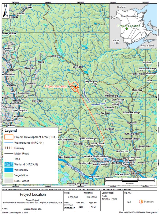
- Figure 1.1: Sisson Project Location
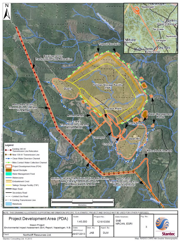
- Figure 2.1: Project Development Area
- Figure 4.1: Alternative Tailings Storage Facility Locations
- Figure 4.2: Tailings Storage Facility Embankment Designs
- Figure 5.1: Watershed Map
- Figure 5.2: Potential Effects on Wetlands
- Figure 5.3: Location of Recreational Camp Sites and Residences Relative to the Project Development Area74
- Figure 5.4: Project Development Area and Regional Assessment Area Defined by the Proponent
- Figure 5.5: Crown Land Blocks in the Regional Assessment Area
- Figure 5.6: Cumulative Effects in the Saint John River Basin
- Figure 10.1: Overview of Major Changes to the Project Layout since April 2011
List of Short Forms and Abbreviations
- Agency
- Canadian Environmental Assessment Agency
- Assembly [1]
- Assembly of First Nations Chiefs in New Brunswick
- CO2e
- carbon dioxide equivalent
- EIA
- Environmental Impact Assessment
- former Act
- Canadian Environmental Assessment Act S.C. 1992, c. 37 , 1992
- H2S
- hydrogen sulphide
- Minister
- Federal Minster of the Environment
- NH3
- ammonia
- NO2
- nitrogen dioxide
- PM
- particulate matter
- Project
- Sisson Project
- proponent
- Sisson Mines Ltd.
- Report
- Comprehensive Study Report
- SO2
- sulphur dioxide
1 INTRODUCTION
1.1 Project Overview
The Sisson Project (the Project) considered in this Comprehensive Study Report (the Report) is a proposed open pit tungsten and molybdenum mine and ore processing facility in central New Brunswick. The Project is being proposed by Sisson Mines Ltd. (the proponent). The proponent, formerly known as Northcliff Resources Ltd., entered into a partnership agreement with Todd Minerals Ltd., in October 2013 to form Sisson Mines Ltd.
The Project would consist of a 145 hectare open pit mine, an ore processing plant, a 751 hectare tailings storage facility, water and waste management systems, a new site access road, and internal site roads. An existing 345 kilovolt transmission line and fire road would be re-routed to accommodate the Project. In addition, a new 42 kilometer long, 138 kilovolt transmission line from the New Brunswick Power Keswick terminal would be constructed and operated by New Brunswick Power to supply electricity to the Project.
The mine would operate for an estimated 27 years at a mining rate of 30,000 dry metric tonnes per day of tungsten- and molybdenum-containing ore, which would be processed at an on-site plant to produce tungsten and molybdenum mineral products. Tungsten concentrate would be further refined on-site to produce a higher-value tungsten product called ammonium paratungstate. Resulting products would be packaged and transported to North American and other markets.
Source: Sisson Project Final Environmental Impact Assessment Report, Stantec Consulting Ltd.
|
Sisson Project |
Sisson Mine Ltd. |
|---|---|
|
Federal Environmental Assessment |
Canadian Environmental Assessment Agency |
|
Canadian Environmental Assessment Registry: |
1.2 Environmental Assessment Process
The Canadian Environmental Assessment Act S.C. 1992, c. 37 , 1992 (former Act) applied to federal authorities that contemplated certain actions or decisions that would enable a project to proceed in whole or in part. Such actions included authorizations, permits, and approvals.
This comprehensive study commenced in April 2011 and is being completed under the former Act, as per the transitional provisions of the Canadian Environmental Assessment Act, 2012, which came into force July 6, 2012.
An environmental assessment of the Project is required under the former Act because Fisheries and Oceans Canada and Natural Resources Canada may issue authorizations, permits or approvals in relation to the Project under the Fisheries Act and Explosives Act, respectively.
Under the Comprehensive Study List Regulations of the former Act, this Project requires a comprehensive study type environmental assessment, as a component of the Project is described in section 16(a): "The proposed construction, decommissioning or abandonment of a metal mine, other than a gold mine, with an ore production capacity of 3 000 t/d or more" (Part V, section 16).
The Canadian Environmental Assessment Agency (the Agency) is responsible for the conduct of the comprehensive study for the Project and prepared this Report in consultation with Fisheries and Oceans Canada, Natural Resources Canada, Environment and Climate Change Canada, and Health Canada.
The Project also required an environmental impact assessment (EIA) pursuant to section 5(1) of New Brunswick 's Environmental Impact Assessment Regulation under the Clean Environment Act. On December 3, 2015, the Province of New Brunswick issued an EIA approval to the proponent for the Project. Information on the provincial EIA process is available on the New Brunswick Department of Environmental and Local Government's website (http://www2.gnb.ca/content/gnb/en/departments/elg/environment/content/environmental_impactassessment/comprehensive_reviews/sisson.html). The Governments of Canada and New Brunswick conducted aspects of the federal and provincial environmental assessments cooperatively.
1.2.1 Purpose of the Comprehensive Study Report
This Report presents a summary of the Agency's analysis of whether the Project is likely to cause significant adverse environmental effects. The analysis and findings are based on the Agency's review of the proponent's EIA Report and associated documents prepared by the proponent, input from federal and provincial experts, and public and First Nations comments in relation to the Project.
The federal Minister of the Environment and Climate Change (the Minister) will consider this Report and comments received from the public and First Nations when issuing an environmental assessment decision statement in relation to the Project. The Minister may request additional information or require that public concerns be addressed further before issuing the decision statement. The Minister will refer the Project back to Fisheries and Oceans Canada and Natural Resources Canada following the environmental assessment decision statement to allow them to take the appropriate course of action in accordance with section 37 of the former Act.
2 PROJECT DESCRIPTION
2.1 Scope of the Project
The scope of the Project for the purpose of the comprehensive study includes all physical works and activities associated with the construction, operations, maintenance, decommissioning, reclamation, and closure of the Project.
2.2 Project Components and Activities
Project components and activities are listed in Tables 2.1 and 2.2. The geographic location of components is illustrated in Figure 2.1.
|
Component |
Purpose/Detail |
|---|---|
|
Open Pit |
The pit from which ore would be mined would be approximately 145 hectares in size (900 meters wide and 1,850 meters long) and 300 to 370 meters deep. |
|
Conveyors |
Conveyors would move crushed rock from the primary crusher to the coarse ore stockpile and from the stockpile to the ore processing plant. |
|
Ore Processing Plant |
An on-site concentrator would produce molybdenum and tungsten concentrates, using conventional crushing, grinding, and flotation technologies. The tungsten concentrate would be further refined on-site to a value-added crystalline product called ammonium paratungstate. |
|
Stockpiles and Storage Areas |
An ore stockpile would be located outside of the ore processing plant on a concrete pad with drainage to the tailings storage facility. Mine waste rock and low grade ore would be stockpiled in the tailings storage facility and submerged. Topsoil storage piles would be established surrounding the perimeter of the tailings storage facility for future use during reclamation activities. |
|
Tailings Storage Facility |
The tailings storage facility would store waste rock, low grade ore and potentially acid generating tailings underwater. The tailings storage facility would be constructed of rock quarried on-site and cover an area of approximately 751 hectares (approximately three kilometers by 2.5 kilometers in dimension). The maximum embankment height would be approximately 76 meters at the final crest elevation of 376 meters above sea level and a topographic low point of 300 meters above sea level. The crest length would be approximately 8.8 kilometers. The theoretical maximum volume of water that could be stored in the tailings storage facility would be approximately 23 million cubic meters. The maximum volume of tailings solids that could be stored in the tailings storage facility would be approximately 247 million cubic meters. Approximately 287 million metric tonnes of waste rock would also be stored under water in the tailings storage facility. |
|
Waste Storage Cells |
Up to six storage cells would be located in the tailings storage facility and used to dispose of waste generated from the process of refining tungsten concentrate to ammonium paratungstate. Wastes include undigested residue from the concentrate digestion process and raffinate [2] generated during the solvent extraction process that converts sodium tungstate to ammonium tungstate. Cells would be double-lined with high-density polyethylene and equipped with a leak detection and recovery system. The first three cells could store 400 000 cubic meters, 300 000 cubic meters, and 650 000 cubic meters of solids, respectively. Additional cells would provide contingency measures in the event that the actual quantity or density of wastes varies from current estimates. |
|
Quarry |
The quarry would cover an area up to approximately 118 hectares (1.2 kilometers long by 0.4 kilometers wide) and would largely be flooded during operations and closure. It would supply rock for the construction of project facilities and tailings storage facility embankments. |
|
Access Roads |
Access to the Project from the New Brunswick highway system would be provided by upgrading two existing forest resource roads (45 and 17 kilometers in length respectively). An existing fire road would be relocated for approximately eleven kilometers in a common corridor with a relocated 345 kilovolt transmission line. |
|
On-Site Buildings |
On-site buildings would include process buildings, an administration building, a laboratory, a truck shop and warehouse, fuel storage, an explosives plant, and explosives and detonator magazines. |
|
Transmission Line |
A 42 kilometer long, 238 kilovolt transmission line would supply power to the Project from the New Brunswick Power Keswick terminal. Nine kilometers of an existing 345 kilovolt transmission line would be re-routed a minimum of 500 meters away from the open pit and quarry. |
|
Leach-bed Sewage System |
Sewage from the process plant, administration building, and laboratory would be treated by a leach-bed system. |
|
Activities and Physical Works |
Description |
|---|---|
|
Site Preparation |
|
|
Construction and Installation of Project Facilities |
|
|
Open Pit Mining |
|
|
Ore Stockpiling |
|
|
Ore Processing |
|
|
Mine Waste and Water Management |
|
|
Transportation |
|
|
Operational and Maintenance Activities |
|
|
Decommissioning, Reclamation, and Closure |
|
|
Post-closure |
|
Source: Sisson Project Final Environmental Impact Assessment Report, Stantec Consulting Ltd.
2.3 Project Schedule
Construction would begin after the Project has received government approvals and permits and project financing has been secured, which the proponent anticipates occurring in 2016. Construction would proceed for a period of up to 24 months. Operations would follow construction and continue for approximately 27 years. Decommissioning of project facilities and reclamation of the site would occur following the completion of operations. Closure would commence during the decommissioning and initial reclamation period and would continue until the open pit lake fills with water, which would take approximately twelve years. Once the open pit is completely full, post-closure activities would begin.
3 SCOPE OF ENVIRONMENTAL ASSESSMENT
A scoping process was conducted to focus the environmental assessment on relevant factors and concerns and to establish its temporal and spatial boundaries, which are described in the Final Terms of Reference for an Environmental Impact Assessment for the Sisson Project, Northcliff Resources Ltd.
3.1 Factors to be Considered
The following factors were considered as part of the comprehensive study pursuant to subsections 16(1) and 16(2) of the former Act:
- the environmental effects of the Project, including the environmental effects of malfunctions or accidents that may occur in connection with the Project and any cumulative environmental effects that are likely to result from the Project in combination with other projects or activities that have been or will be carried out;
- the significance of the environmental effects referenced above;
- comments from the public that are received in accordance with the former Act and regulations;
- measures that are technically and economically feasible and that would mitigate any significant adverse environmental effects of the Project;
- the purpose of the Project;
- alternative means of carrying out the Project that are technically and economically feasible and the environmental effects of any such alternative means;
- the need for, and the requirements of, any follow-up program in respect of the Project, and
- the capacity of renewable resources that are likely to be significantly affected by the Project to meet present and future needs.
In accordance with paragraph 16(1)(e) of the former Act, the Agency also required an assessment of the need for the Project, an evaluation of alternatives to the Project, and an examination of the benefits of the environmental assessment to Canadians.
In addition to the requirements of the former Act, the Species at Risk Act requires responsible authorities to identify adverse effects of projects on listed species and their critical habitats and residences, and to ensure that these effects are mitigated, using measures consistent with species recovery strategies and action plans, as applicable, and monitored. The environmental assessment considered effects on species listed on Schedule 1 under the Species at Risk Act (Appendix A). It also considered impacts on species listed by the Committee on the Status of Endangered Wildlife in Canada.
3.2 Scope of the Factors Considered and Spatial and Temporal Boundaries
The environmental assessment focused on aspects of the natural and human environments that have particular value or significance and may be affected by the Project. These are referred to as valued components. Valued components assessed by the proponent in its EIA Report are listed in Table 3.1. The proponent defined local and regional assessment areas to focus its assessment of impacts on valued components as follows:
- the local assessment area is the maximum area within which project-related environmental effects can be measured with a reasonable degree of accuracy and confidence and
- the regional assessment area includes the local assessment area and areas within which the Project's environmental effects may overlap or accumulate with the environmental effects of other projects or activities.
|
Valued Component |
Local Assessment Area Boundary |
Regional Assessment Area Boundary |
|---|---|---|
|
Atmospheric Environment |
|
|
|
Acoustic Environment |
|
|
|
Water Resources |
|
|
|
Aquatic Environment |
|
|
|
Terrestrial Environment |
|
|
|
Vegetated Environment Wetland Environment |
|
|
|
Public Health |
|
|
|
Land and Resource Use |
|
|
|
Current Use of Land and Resources for Traditional Purposes by Aboriginal Persons |
|
|
|
Heritage Resources |
|
|
Temporal boundaries for the assessment were defined based on the timing and duration of project activities and the nature of the interaction with each valued component. Temporal boundaries included all project phases (i.e. construction, operations, decommissioning, reclamation, and closure).
The Agency divided the valued components identified by the proponent into the ten components listed below to focus this Report. The predicted environmental effects of the Project on these components are summarized in this Report and presented in conjunction with the Agency's conclusions about the likely significance of environmental effects, taking into account the implementation of mitigation measures.
- Atmospheric environment (section 5.2)
- Water resources (section 5.3)
- Fish and fish habitat (section 5.4)
- Terrestrial wildlife and habitat (section 5.5)
- Vegetated environment (section 5.6)
- Wetland environment (section 5.7)
- Human health (section 5.8)
- Land and resource use (section 5.9)
- Current use of lands and resources for traditional purposes by Aboriginal peoples (section 5.10)
- Heritage resources (section 5.11)
This Report also discusses potential accidents and malfunctions (section 6.1) as well as changes to the Project that may be caused by the environment (section 6.2).
A list of species at risk that may be found within or near the local assessment area for the Project is included in Appendix A. The impacts of the Project on these species at risk were considered as part of the assessment of valued components.
3.3 Need for and Purpose of the Project
The former Act requires consideration of the need for and purpose of a project. The proponent stated that the need for the Project is to supply worldwide market demands for tungsten and molybdenum, and help alleviate supply shortages of tungsten caused by export restrictions implemented by China. Supplies from the Project would be available to meet market demands in North America and elsewhere. The purpose of the Project is to mine tungsten- and molybdenum-containing ore from the Sisson deposit, process ore to meet market demand for the mineral products, and create return on investment for the shareholders of Sisson Mines Ltd.
4 Project Alternatives
4.1 Alternatives to the Project
The former Act requires consideration of alternatives to a project. The proponent did not identify any alternatives to the Project that would meet the need for and purpose of the Project as described in section 3.3. Any alternatives that could potentially address the need for and purpose of the Project are outside the proponent's influence and control. The only alternative considered by the proponent is the null or "do nothing" alternative. In this regard, if the Project is not carried out, the biophysical environment would remain unchanged from its existing condition, but the need for and purpose of the Project would not be realized.
4.2 Alternative Means of Carrying Out the Project
The former Act requires consideration of technically and economically feasible alternative means of carrying out a project, and the environmental effects of these alternative means. A summary of alternative means considered is presented below. Additional information on alternative means, including effects and considerations examined in selecting preferred options, is presented in Appendix B.
4.2.1 Tailings Storage Facility Location
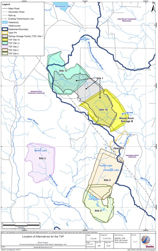
The proponent initially considered four sites (i.e. Bird Brook, Barker Lake, Trouser Lake, and Chainy Lakes) as potential locations for the tailings storage facility (Figure 4.1). Following a preliminary assessment of these sites, Bird Brook was identified as the preferred option due to environmental, technical, and economic reasons, and was the only site retained for further evaluation. Bird Brook was subsequently refined into two separate alternatives (referred to as Site 1b and Site 1c). A multi-criteria analysis that considered technical, economic, and environmental factors was undertaken to compare the two sites. Site 1b was selected by the proponent as the preferred site for the tailings storage facility due to lower capital and operating costs, a shorter distance to the processing plant, and lower greenhouse gas emissions.
Views Expressed
The Agency requested additional information on the economic and technical feasibility of the four tailings storage facility sites initially considered and the potential environmental effects of these alternatives. The proponent responded that of the four alternatives originally considered, three had been eliminated from further consideration due to their greater distance to the processing plant and the comparatively greater costs of operations. In addition, the proponent noted that the fourth site (Bird Brook) covers no lakes and drains entirely to a single watershed, the Napadogan Brook Watershed. Of the two remaining sites, Site 1b was ultimately chosen as the preferred alternative because it would enable: a centralized approach to water treatment; a single point of discharge; a smaller area of permanent wetland loss; and reduced operational costs.
Environment and Climate Change Canada advised that because the Project would require the use of natural water bodies frequented by fish for the disposal of mine waste, an amendment to the Metal Mining Effluent Regulations, Schedule 2 would be required. Accordingly, the proponent was asked to consider alternatives to the use of fish-bearing waters for waste rock and tailings disposal in accordance with Environment and Climate Change Canada's Guidelines for the Assessment of Alternatives for Mine Waste Disposal. This information and analysis was provided to Environment and Climate Change Canada in the Fall of 2015.
Source: Sisson Project Final Environmental Impact Assessment Report, Stantec Consulting Ltd.
4.2.2 Tailings Management Technology
The proponent considered three tailings management technologies: un-thickened slurry tailings, paste tailings, and filtered dry stack tailings. It determined that conventional slurry tailings disposal was the best option for the Project because potentially acid generating tailings and waste rock would be stored sub-aqueously and encapsulated, thereby mitigating the potential for acid generation. The proponent stated that other options would present technical challenges due to the location of the Project and local climate, or were economically less desirable due to energy requirements.
Views Expressed
The public requested that the proponent re-consider the benefits of dry stack tailings. This option would involve the disposal of tailings on high ground away from watercourses and the re-vegetation of waste piles. The Province of New Brunswick recommended a combination of dry stack inert tungsten tailings and a lined tailings storage facility be considered, and that the proponent give long term liability a greater priority in its analysis. The proponent responded that a synthetic liner system over the whole tailings storage facility basin would not be economically feasible and maintained that dry stack tailings management presents challenges due to climatic conditions in the area, operating costs, and the physical characteristics of the tailings. As part of the Province of New Brunswick's conditions of EIA approval, the proponent is required to establish and fund an Independent Tailings Review Board prior to construction to evaluate that the proposed design, construction, and performance of the tailings storage facility is consistent with good practice and best available technology.
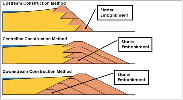
4.2.3 Tailings Storage Facility Embankment Design
The proponent considered three methods of constructing embankments for the tailings storage facility: upstream, centreline, and downstream (Figure 4.2). The centreline method was selected as the preferred alternative by the proponent due to its superior seismic resistance, reduced foundation footprint, and the efficient use of non-mineralized rock for construction. The proponent stated that it would incorporate compacted tailings on the upstream side of the embankments to reduce seepage. This modified design would provide security against slope failure and meet or exceed the factors of safety in applicable Canadian Dam Association guidelines.
Source: Sisson Project Final Environmental Impact Assessment Report, Stantec Consulting Ltd.
Views Expressed
Environment and Climate Change Canada noted that the downstream method of tailings storage facility embankment design, with a low permeability compacted glacial till core keyed into bedrock, is the preferred management practice for seepage prevention and control. The proponent responded that use of such a core can be designed into either a centreline or downstream tailings storage facility embankment; however, suitable fine-grained glacial till required for construction of the core does not exist in sufficient quantities within reasonable haul distance to the tailings storage facility. Accordingly, this option was dismissed by the proponent as economically unfeasible.
The Agency requested clarification on the technical and economic feasibility of embankment designs and associated environmental effects. Additional information on stability (in the event of seismic activity) and failure rates of centreline and downstream embankments were also requested by the Province of New Brunswick. The proponent responded that the upstream construction method would not be technically feasible due to its relatively poor seismic resistance compared with the other options. While the downstream method is technically feasible, the proponent stated that it would require additional rockfill and a larger footprint, would offer no additional benefit in terms of seepage or resistance to extreme seismic events, and would offer no additional capacity to manage extreme storm events when compared to the centreline design. As part of its conditions of EIA approval, the Province of New Brunswick will require the proponent to commission an Independent Tailings Review Board prior to construction to evaluate that the proposed design, construction and performance of the tailing storage facility is consistent with good practice and best available technology.
4.2.4 Decommissioning, Reclamation and Closure
The proponent developed a Conceptual Reclamation and Closure Plan for the Project. Following operations, all facilities, buildings, and other infrastructure would be removed, except those required for ongoing care and maintenance (e.g. water management and treatment systems, scaled-back administration office, one or two small buildings for storage, and essential roads, power lines, and on-site power supplies), and the project site would be reclaimed. During decommissioning, the open pit would be filled with water for safety reasons and to address the potential for acid generation from pit walls.
Views Expressed
The Agency requested that alternative options and desired outcomes for decommissioning, reclamation and closure be further evaluated. The proponent clarified its reclamation objectives and noted that, due to the nature of the Project, applicable land could not be restored to its present state following decommissioning. However, the Conceptual Reclamation and Closure Plan proposes to restore the site as close to existing conditions as technically and economically possible. The proponent stated that backfilling the open pit would not be technically and economically feasible. It committed to working with stakeholders and First Nations during operations to consider alternative means of reclamation and closure so as to arrive at agreed upon end land uses.
Maliseet and Mi'gmag First Nations requested additional consideration of alternatives that would avoid the need for perpetual water treatment at the site. The proponent stated that its goal would be to minimize or avoid treatment of surplus water before discharge during the post-closure phase. Accordingly, it would continue to refine its predictive water quality modelling during operations and adapt consequent waste and water management and treatment accordingly.
As part of its conditions of EIA approval, the Province of New Brunswick would require the proponent to develop a conceptual Closure and Post-Closure Monitoring Program that establishes targets and thresholds for determining reclamation success and mitigation effectiveness. The plan would be required to integrate data generated from other monitoring programs and developed with appropriate input from regulatory authorities, First Nations, and stakeholders.
Maliseet and Mi'gmag First Nations asked the proponent to consider alternative options, such as engineered wetlands, to treat water from the Project. The proponent responded that engineered wetland systems for uncollected seepage may be evaluated if they are deemed appropriate. However, it stated that wetlands are best employed as a ‘polishing' step after other forms of treatment and are not likely suitable for the Project on their own. Based on the predicted chemistry of tailings storage facility water, a strictly anaerobic environment in a wetland would be required to remove many of the elements of concern; however, this may not be practical for the Project given high seasonal precipitation variability and cold winters.
4.2.5 Other Alternative Means
Other alternative means of carrying out of the Project assessed by the proponent are summarized in Appendix B. These include options for fish habitat compensation, management of waste from the ammonium paratungstate plant, and alternative routes for roads and transmission lines. Alternatives were not considered for the location of the pit, given that it is fixed by the location of the ore body. Alternative mining methods were also not assessed because the proponent stated that only open-pit mining would be technically and economically feasible given the location of the ore body near the surface. The location of the processing plant was selected based on proximity to the open pit, so as minimize costs, footprint, and transportation requirements.
4.2.6 Agency Analysis and Conclusion
The Agency carried out a review of the rationale and method for selecting preferred alternative means and is satisfied that the proponent adequately considered technically and economically viable alternative means of carrying out the Project, and identified preferred means that take into account differences in the environmental effects of the alternatives [3].
5 ENVIRONMENTAL EFFECTS ASSESSMENT
5.1 Approach to Environmental Effects Assessment
The Agency, in collaboration with federal departments, identified and assessed the potential adverse environmental effects of the Project on the basis of:
- the proponent's EIA Report and associated information (e.g. reports, technical documents);
- information obtained during public and Aboriginal consultations and the proponent's responses to resulting comments;
- comments from federal and provincial government agencies and the proponent's responses to resulting comments; and
- mitigation and follow-up requirements the Agency considers necessary (Appendices C and D).
This Report is a summary of the environmental assessment process to date. Sections 5.2 to 5.11 of this Report discuss the potential environmental impacts of the Project in relation to valued components. These sections are organized into the following format:
- Proponent's Assessment of Environmental Effects and Proposed Mitigation – a description of the proponent's assessment of the potential effects of the Project and of associated cumulative effects is presented. The proponent's general environmental assessment methods are described below.
- Views Expressed – an accounting of key issues raised by First Nations, the public, and government is presented in conjunction with the proponent's responses.
- Agency Analysis and Conclusions – the Agency's analysis of residual effects of the Project on each valued component is presented in conjunction with its conclusion on the significance of these effects, taking into account the implementation of mitigation measures. The determination of the significance of residual effects on valued components is based on the methodology set out in the Reference Guide: Determining Whether a Project is Likely to Cause Significant Adverse Environmental Effects and includes consideration of criteria such as magnitude, geographic extent, duration, frequency, reversibility, and ecological and cultural context. Follow-up requirements deemed necessary by the Agency are also specified.
Proponent's Environmental Assessment Methods
In its EIA Report and associated documents, the proponent described the existing environmental (baseline) conditions and proposed Project. The environmental effects of the Project on valued components were predicted taking into account criteria including:
- direction – the ultimate long-term trend of the environmental effect (i.e. positive or adverse);
- magnitude— the amount of change in a measurable parameter or variable relative to existing (baseline) conditions;
- geographic extent—the area where an environmental effect of a defined magnitude occurs;
- frequency – the number of times during the Project or a specific project phase or activity that an environmental effect might occur (e.g. one time or multiple times) in a specified time period;
- duration – the period of time required until the valued component returns to its baseline condition or environmental effects can no longer be measured or otherwise perceived (e.g. short-term, mid-term, long-term, or permanent);
- reversibility – the likelihood that a measurable parameter will recover from an environmental effect, including through active management techniques; and
- ecological/socioeconomic context – the general characteristics of the area in which the Project is located, as indicated by past and existing levels of human activity.
The proponent proposed measures to mitigate or avoid the residual adverse environmental effects of the Project (Appendix E). It further proposed definitions of significance in relation to each valued component. The definitions used by the proponent in the assessment of significance are described in Appendix F.
5.2 Atmospheric Environment
The atmospheric environment includes air quality, greenhouse gas emissions, noise, odour, vibration, and the visual environment.
Description of Baseline Environment
The closest permanent human receptors to the Project are recreational campsites located approximately 1.5 kilometers southeast of the open pit and permanent residences in Napadogan approximately ten kilometers northeast of the Project.
Air quality in the Napadogan area near the Sisson site is representative of that found in rural, sparsely populated areas, with no substantive sources of air contaminant emissions nearby. The measured 24-hour average concentrations of particulate matter (PM) and PM2.5 in the project area are well below the New Brunswick Department of Environment and Local Government's objective and Canada-wide Standard [4], respectively. Trace metals are currently below relevant Ontario air quality criteria [5] and air ground-level concentrations of nitrogen dioxide (NO2) and sulphur dioxide (SO2) are also very low.
Existing noise sources in the local area include vehicle traffic on Route 107 and activities at the recreational campsites. The sound quality in the regional assessment area varies depending on the proximity to the provincial road system. Sound quality at the recreational campsites is typical of a rural environment with occasional influences from anthropogenic sources, particularly on weekends.
5.2.1 Proponent's Assessment of Potential Environmental Effects and Mitigation
Air Emissions
Emissions to air as a result of the Project would occur primarily as a result of:
- vehicle and equipment movement on unpaved roads (fugitive dust),
- material handling and processing (fugitive dust),
- blasting in the open pit (fugitive dust),
- wind erosion on overburden storage piles and exposed surfaces of the tailings storage facility (fugitive dust),
- fuel combustion in mobile equipment and package boiler providing heat to the ore processing plant (combustion gases including greenhouse gases), and
- operations of the ore processing and ammonium paratungstate plants (particular matter, volatile organic compounds, potentially odourous compounds including hydrogen sulphide (H2S) and ammonia (NH3)).
Direct annual greenhouse gas emissions are predicted to be 27,210 tonnes carbon dioxide equivalent (CO2e) for the construction phase and 47,691 tonnes CO2e for the operations phase of the Project. The proponent states that the mine is below the Canadian average greenhouse gas intensity for metal mines.
Dispersion modeling, based on the proponent's projected emissions, shows that the Project would not result in exceedances of ground-level air quality objectives for SO2, NO2, carbon monoxide (CO), NH3, and H2S, during construction and operations, as applicable. Total PM and PM10, but not PM2.5, may on occasion exceed air quality objectives in the New Brunswick Air Quality Regulation (Regulation 97-133) under the Clean Air Act due to fugitive emissions from road dust on off-site access roads during construction and operations. However, the proponent predicted that exceedances would be brief, localized, and infrequent while vehicles pass during dry conditions. In addition, occasional exceedances (0.2 percent of the time) of the 24-hour total PM objective were predicted within approximately 20 meters southwest of the primary crusher during operations. Predicted maximum ground-level concentrations of particular matter (PM), PM10 and PM2.5 during construction and operations are below the applicable objectives and standards at the nearest residences in Napadogan and recreational campsites.
Measures to mitigate impacts of air emissions include an idling reduction program, application of water to site access roads and on-site roads to reduce dust generation, re-vegetation of topsoil and overburden storage piles after disturbance, and equipment and vehicle maintenance to improve operational efficiency and reduce emissions. Dust collection systems on the primary crusher and within the ore processing plant, partially covering ore conveyors, and use of scrubbers on the ammonium paratungstate plant are also proposed. These measures would be described in dust suppression mitigation and air quality management plans, which would be developed as part of the Environmental Protection Plan. Further mitigation is described in Appendix E.
Odour, Noise, and Vibration
During construction, sound (noise) and vibrations would result from equipment associated with earth moving, building installation, quarrying, access road construction, and transportation of personnel and materials. During operations, sound and vibrations would be generated from: heavy equipment; drilling and blasting of ore and rock; transportation of personnel, materials, and products; crushing and conveying equipment; and processing equipment.
Sound emission estimates and sound pressure level modelling show that, with the exception of sound emissions from blasting events, activities during construction and operations are not expected to be noticeable at residences in Napadogan nor at the nearest recreational campsite. Measures to mitigate the effects on the acoustic environment include enclosing processing equipment in buildings and using mufflers.
During operations, blasting in the open pit is expected to occur approximately two to three times per week (approximately 178 events per year) and in the quarry once per week for three months of the year (approximately twelve events per year). The proponent stated that blasting would not be noticeable at Napadogan. Blasting would be audible at the recreational camps; however, the proponent stated that the period would be brief (approximately two seconds at a time) and vibration amplitude would be small (similar to the vibration caused by a large bulldozer operating 7.6 meters away). Communication of blast times to camp owners would provide advanced warning and minimize annoyance. Other mitigation measures proposed by the proponent include avoiding night time blasting, whenever feasible, and minimizing the frequency of blasts.
Projected emissions from the ammonium paratungstate plant may result in an exceedance of the ten-minute odour threshold for H2S during operations near the plant. However, occurrences are expected to be infrequent (0.03 percent of the time), localized near the plant, and of short duration. The proponent stated that no perceivable odour is expected beyond approximately 20 meters from the ammonium paratungstate plant.
The proponent predicted that the residual effects of the Project on the atmospheric environment would be medium in magnitude, occur locally, occur continuously or on a regular basis over the life of the Project, and be reversible. Taking into account the mitigation measures proposed (Appendix E), the proponent concluded that the residual adverse effects of the Project on the atmospheric environment were unlikely to be significant.
Cumulative Environmental Effects
There are no other past or present projects or activities that have been carried out for which the environmental effects would be expected to overlap those of the Project on the atmospheric environment. Future activities that could interact cumulatively with the Project to affect the atmospheric environment include forestry, industrial land use, and future residential development. Logging equipment and trucks release combustion gases and greenhouse gases, and may cause fugitive road dust emissions during operations; however, these emissions are transient as logging operations continue and are not expected to be substantive. Forestry activities carried out in the future could have overlapping environmental effects with those of the Project, but given that background levels are low, the proponent stated that it is not conceivable that these activities would cause a long-term concern with respect to meeting ambient air quality objectives in the area. Other than dust arising from vehicle traffic on unpaved roads, fugitive particulate matter from project activities are not expected to reach the recreational campsites or the nearest residences. Other recreational land uses do not generate substantive emissions that would be expected to exceed ambient air quality objectives or standards in combination with emissions from the Project. Future cumulative interactions between the Veneer Mill and the Project would be minimal given the distance (ten kilometers) between the projects.
The proponent stated that the Project's contribution to global greenhouse gas emissions would be negligible and that cumulative environmental effects on the acoustic environment are not expected to be substantive. High levels of sound emissions from other projects or activities would not occur proximal to the Project, thus with no substantive spatial overlap. Residual cumulative environmental effects are predicted to be not significant.
Monitoring and Follow-Up
The proponent committed to investigate any complaints received, including those related to air quality, odour, visibility, noise and vibration.
If complaints related to air emissions are received, the proponent would consider monitoring ambient total PM (e.g. dust, other contaminants as applicable) to determine if concentrations at the nearest receptors meet standards and objectives.
The volume of fuel combusted in stationary equipment during operations would be tracked to enable estimation of annual greenhouse gas emissions. This information would be used to evaluate whether federal reporting thresholds are reached as well as potential provincial reporting requirements.
During construction and early operations, the proponent would conduct periodic sound and vibration monitoring at the nearest recreational campsites to confirm that sound pressure levels and peak particle velocities are within acceptable ranges (e.g. below significance criteria and standards and objectives).
5.2.2 Views expressed
In response to concerns about dust and associated effects, the proponent committed to mitigation measures described in Appendix E, including development and implementation of a Dust Suppression Plan. The Province of New Brunswick also indicated that dust fall monitoring near the Project would be required should the Project be approved. Concerns about potential health effects from dust disposition on country foods are discussed in section 5.8.
The potential for effects on visibility were raised as a concern by Maliseet and Mi'gmag First Nations. The proponent predicted that reduced visibility is not likely to occur beyond the project development area and that proposed mitigation would likely maintain acceptable dust levels. It committed to investigating visibility complaints should they occur. Environment and Climate Change Canada and the Province of New Brunswick agreed with the proponent's predictions related to impacts on visibility.
Environment and Climate Change Canada and the Province of New Brunswick asked about trace metals in overburden and the potential for corresponding emissions to air. The proponent stated that overburden has a low potential to have a high metal content. Nonetheless, it committed to undertaking additional test work to confirm that overburden stockpiles would not pose a risk to air quality and managing stockpiles accordingly.
The Province of New Brunswick, Health Canada, Environment and Climate Change Canada, and the public requested clarification on the design of the ammonium paratungstate plant including estimated emissions and health effects of H2S, NH3, and SO2. The proponent confirmed that the ammonium paratungstate plant would be equipped with scrubbers to minimize the release of H2S and NH3. The plant would not produce SO2 since sulphur would be removed during the purification process, stored in drums, and disposed of off-site at an approved facility. Environment and Climate Change Canada requested that predicted emissions from the ammonium paratungstate plant be validated during the initial phases of operations. As part of its conditions of EIA approval, the Province of New Brunswick would require the proponent to obtain approval to construct and operate the Project, including the ammonium paratungstate plant, under the Air Quality Regulation under the Clean Air Act. This approval process would include additional modelling and further detail on the design and operation of the ammonium paratungstate plant and its associated emissions, as well as a requirement to validate the predicted emissions during initial phases of operations.
Maliseet and Mi'gmag First Nations asked about the potential for odours from the Project. The proponent responded that odour issues on site or off-site were unlikely; however, committed to investigating odour complaints should they occur. Environment and Climate Change Canada was satisfied with proponent's assessment of odour and stated that the provincial complaints handling procedure and reporting requirements would be sufficient to address potential complaints. As part of the Province of New Brunswick's conditions of EIA approval, the proponent would be required to develop a Public Complaints Protocol to address complaints and concerns associated with the Project, including mandatory reporting of all complaints, corrective actions, and/or proponent response to complaints.
Maliseet and Mi'gmag First Nations raised concerns about noise from the Project, particularly its effects on the enjoyment of the project area which is valued for its peacefulness and tranquility. Health Canada stated that modelling should be adjusted to account for: blasting noise; increased sensitivity to noise during night-time hours; and greater expectation for peace and quiet due to the rural nature of the project area. The proponent submitted additional modelling results with the suggested adjustments. Values were below applicable Health Canada guidance for which additional mitigation would be required. For instance, the proponent clarified that there would be a slight change (not including blasting events) in percent highly annoyed, an indicator of auditory disturbance, for people at the closest residential receptors (Napadogan) and the closest recreational campsite, but this increase would be within acceptable levels [6]. Health Canada noted that sound pressure levels during blasting at the nearest recreational campsite (80 A-weighted decibels [7]) would be higher than the recommended 45 A-weighted decibels, based on annoyance and sleep disturbance and recommended that night-time blasting be avoided. The proponent indicated that it would minimize or avoid blasting at night, whenever practical, and monitor sound and vibration at the nearest campsite to verify predictions and adapt, as appropriate.
In response to First Nation's questions, the proponent provided information on baseline data, acidification, source locations, timing of project emissions, model inputs, and the assessment of cumulative effects. Environment and Climate Change Canada stated that it was satisfied with the responses provided by the proponent. As part of its conditions of EIA approval, the Province of New Brunswick would require additional and ongoing baseline air quality datasets for PM10, H2S and NH3 modelling and monitoring. In addition, an Environmental Management Plan would be developed and would include mitigation for air quality, a monitoring plan, adaptive management considerations, and contingency plans. Health Canada recommended that the proponent also establish baseline conditions to verify ambient concentration predictions for total PM, PM2.5, and SO2. Maliseet and Mi'gmag First Nations requested that they be provided with air quality monitoring data in order to make informed decisions about harvesting and land use activities. They advised that this could be achieved through on-going involvement of First Nations in follow-up programs. The proponent has committed to involving Maliseet and Mi'gmag First Nations in developing monitoring programs.
Environment and Climate Change Canada, Health Canada, and the Province of New Brunswick have advised the Agency that the proposed mitigation measures, monitoring commitments, and follow-up would adequately address the potential effects of the Project on the atmospheric environment.
5.2.3 Agency Analysis and Conclusion
The Agency notes that the proponent committed to ensuring that all atmospheric emissions would be within applicable provincial regulations, standards and guidelines at the nearest populated areas. However, some exceedances of ambient air quality objectives for total PM are predicted to occur when vehicles pass during dry conditions or occasionally within approximately 20 meters of the primary crusher (i.e. 0.2 percent of the time). The Agency is aware that New Brunswick's conditions of EIA approval would require the proponent to: submit baseline air quality studies for PM10, H2S, and NH3; conduct additional preconstruction surveys of baseline contaminant concentrations of country foods used by First Nations; and undertake additional dust deposition modelling on vegetation. It would also require monitoring of air quality, including air contaminant emissions and ambient total PM concentrations. With respect to potential impacts of dust, New Brunswick's conditions of EIA approval would require the proponent to monitor dust fall near the project site and develop a Dust Suppression Plan, which would describe effects monitoring, adaptive management considerations, and contingency plans. First Nations would be involved in the development and implementation of follow-up and monitoring plans.
The Agency notes that sound pressure levels during blasting at the nearest recreational campsite would be higher than the recommended 45 A-weighted decibels, based on annoyance and sleep disturbance and accepts Health Canada's recommendation that night-time blasting should be avoided. The Agency considers the proponent's commitment to monitor sound and vibration at the nearest campsite and to address any complaints received to be sufficient to address any issues that may arise. It is noted that the Province of New Brunswick would require the proponent to develop a Public Complaints Protocol prior to construction to address complaints and concerns associated with the Project, including mandatory reporting of all complaints, corrective action, and/or proponent response to complaints.
Government departments asked for additional information on emissions from the ammonium paratungstate plant, which the proponent predicted could exceed the 10-minute standards and objectives (i.e. odour) for H2S during operations near the plant. The Agency notes the proponent predicted that such occurrences are expected occasionally (i.e. 0.03 percent of the time) and would be localized (i.e. within 20 meters of the plant). Reporting and acting on complaints would be a requirement of the Province of New Brunswick's approvals process. In addition, the Province of New Brunswick would require the proponent to provide further information on the operation and emissions of the ammonium paratungstate plant during the New Brunswick approvals process. It would also require monitoring of air contaminant emissions (e.g. H2S, SO2, NH3) at the ammonium paratungstate plant.
While the Agency believes that the mitigation proposed by the proponent and required by the Province of New Brunswick would be adequate in mitigating impacts of the Project; monitoring during construction and operations would be important in verifying impact predictions and enabling adaptive management, if warranted.
Taking into account the mitigation measures proposed by the proponent, recommended by Health Canada, and required by the Province of New Brunswick (Appendix C), the Agency considers that the adverse residual effects of the Project on the atmospheric environment would be: medium in magnitude, occur locally (with the exception of greenhouse gases), and occur continuously or on a regular basis over the life of the Project, which is close to 30 years. However, the Agency believes that impacts of emissions would be reversible over the long-term. Taking into account applicable mitigation, the Agency is of the view that the Project is not likely to result in significant adverse environmental effects on the atmospheric environment.
5.3 Water Resources
Description of Baseline Environment
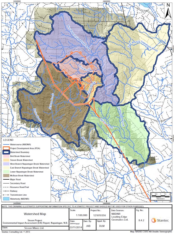
The Project is located within the Napadogan Brook watershed, with a small portion within the McBean Brook watershed (Figure 5.1). Napadogan Brook and McBean Brook are tributaries of the Nashwaak River, which enters the St. John River at the city of Fredericton, New Brunswick.
Source: Sisson Project Final Environmental Impact Assessment Report, Stantec Consulting Ltd.
Surface Water
Water characteristics for the Napadogan Brook and McBean Brook watersheds are similar; soft, coloured, naturally-acidic water with low total dissolved solids. Dissolved anions, nutrients, turbidity, and total suspended solids are generally low.
Key indicators of water quality including dissolved oxygen, E. coli, nitrate, and pH seldom exceed the Canadian Water Quality Guidelines for the Protection of Aquatic Life (Freshwater), indicating that surface waters are, in general, suitable for supporting a variety of fish populations. However, baseline concentrations of aluminum and cadmium within the project development area consistently exceed the Canadian Water Quality Guidelines for the Protection of Aquatic Life (Freshwater), with less frequent guideline exceedances for iron and mercury and rare exceedances for copper, zinc, arsenic, and lead.
The total suspended solids concentrations in the Napadogan Brook watershed are higher than those in the McBean Brook watershed, resulting in more frequent exceedances in the Guidelines for Canadian Drinking Water Quality limits for total iron, total manganese, dissolved iron, and dissolved manganese in the Napadogan Brook watershed.
Surface water users within the local assessment area include several recreational campsites located near Napadogan Brook below Sisson Brook, approximately 1.5 kilometers southeast of the open pit.
Groundwater
Groundwater quality within the local assessment area is good, characterized as soft with low total dissolved solids with a few parameters (pH, arsenic, iron, lead and manganese) exceeding the Guidelines for Canadian Drinking Water Quality. Drinking water guideline limits for iron and manganese are for aesthetic purposes only (i.e. not health-based).
Seasonal fluctuation in water levels in the project development area indicated minimal change in groundwater storage. Groundwater recharge rates within the local assessment area were estimated to be eight percent of the total precipitation within the watershed, or 109 millimetres per year. The average annual groundwater (base flow) component of stream flow is estimated to be in the order of 10.8 litres per second per square kilometer.
There are no known groundwater users within the local assessment area, although some recreational campsites near Napadogan Brook may use groundwater as a potable supply. The nearest known groundwater users within the regional assessment area are located in Napadogan about nine kilometers away from the Project.
5.3.1 Proponent's Assessment of Potential Environmental Effects and Mitigation
The primary mechanisms for the Project to interact with water resources are:
- discharges of water through treated effluent discharge (during operations and post-closure) or through seepage underneath and through the embankments of the tailings storage facility (during operations, closure and post-closure) and
- changes to hydrology as a result of alterations to the land surface from project facilities (e.g. open pit, tailings storage facility).
Effects on Water Quality
Mine contact and process water and water used by the various other project activities would be collected in the tailings storage facility. For the first seven years of operations, there would be no need to release water from the tailings storage facility as stored water would be used for processing ore. However, starting at about year eight of operations, it is projected that water in the tailings storage facility would be in surplus and require release to the environment. Water not meeting regulated water discharge criteria (i.e. Metal Mining Effluent Regulations pursuant to the Fisheries Act and New Brunswick's certificate of approval) would be treated at an on-site treatment plant, using a ferric co-precipitation process, to meet specified criteria, and released in a controlled manner with appropriate monitoring.
Storage of tailings and waste rock within the tailings storage facility may result in seepage of metal contaminated water through the embankments toward local streams and into the groundwater under the tailings storage facility and down gradient, following groundwater pathways to local streams. Perimeter engineered drainage collection channels at the toe of the tailings storage facility embankments and lined water management ponds would collect most of this seepage. Some seepage would escape to the receiving environment, potentially affecting down gradient/downstream water quality. Groundwater pump-back wells would be installed below the northwestern tailings storage facility embankment to collect some groundwater seepage, which would be pumped back to the tailings storage facility to reduce water quality effects in Napadogan Brook. Groundwater quality monitoring wells would be established below water management ponds, and could be converted to pump-back wells if required to ensure downstream water quality objectives are met.
Groundwater seepage from beneath the tailings storage facility into receiving waters would continue in perpetuity. Water quality monitoring would continue post-closure until such time that the water quality is acceptable and, with the approval of regulatory agencies, monitoring and the operation of pump-back wells would be terminated.
Waste rock and quarry materials would be managed to avoid acid generation and metal leaching so as to avoid impacts on water quality. Tailings storage facility starter dams would be constructed of non-potentially acid generating local borrow material or rock quarried from the northwestern corner of the tailings storage facility. Potentially acid generating waste rock and tailings would be submerged in the tailings storage facility, reducing the rate of oxidation of these materials and preventing the potential for acid drainage. The open pit would be flooded during closure to prevent acid generation and metal leaching from the pit walls. Water levels in the pit would be maintained to ensure it acts as a groundwater sink (i.e. maintained so the groundwater flows towards it the rather than away). This would be achieved by water treatment an on-site plant and discharging surplus water into Sisson Brook channel. The proponent assumed that the duration of water treatment post-closure would be required in perpetuity. However, it reported that it is possible that rates of acid generation would decrease over time to a rate where perpetual treatment would not be required.
Waste generated from refining tungsten concentrate to ammonium paratungstate would be placed in storage cells within the tailing storage facility basin. The cells would be double-lined with high density polyethylene and equipped with a leak detection and recovery system to ensure they would not leak to the tailings storage facility during operations, and eventually closed and encapsulated within the closed tailing storage facility.
The proponent predicted that, as a result of treated mine effluent released from the water treatment plant and seepage from the tailings storage facility, there would be exceedances of Canadian Water Quality Guidelines for the Protection of Aquatic Life (Freshwater) for aluminum, cadmium, fluoride, arsenic, chromium, selenium, and copper in water downstream of the mine. However, at discharge all parameters were predicted to be within end-of pipe limits prescribed by the Metal Mining Effluent Regulations under the Fisheries Act. The timing of guideline exceedances would coincide with the discharge of water from the tailings storage facility (starting in year eight of operations and post-closure water treatment plant discharge starting in Year 40). Predicted exceedances in Canadian Water Quality Guidelines for the Protection of Aquatic Life (Freshwater) would be within two kilometers of the mine site. Downstream of the confluence of Sisson Brook and West Branch Napadogan Brook, metal concentrations would decrease. Exceedances were predicted to be most frequent during periods of low natural flow in winter and late summer. A summary of predicted exceedances of Guidelines for Canadian Drinking Water Quality and Canadian Water Quality Guidelines for the Protection of Aquatic Life (Freshwater), along with graphic illustrations is contained in Appendix G.
Overall, the Proponent predicted that exceedances of the Canadian Water Quality Guidelines for the Protection of Aquatic Life (Freshwater) would be localized and intermittent in nature (with the exception of cadmium) and, based on conservative assumptions, were unlikely to substantially alter water quality of the receiving waters over the long-term.
Effects on Surface and Ground Water Quantity
The construction of the open pit, quarry, tailings storage facility, and related engineered drainage collection and diversion channels would result in the permanent alteration of stream flows in Bird Brook, Sisson Brook, Napadogan Brook, and McBean Brook. The largest flow reductions in Bird, Sisson and Napadogan Brooks would be when water is being collected in the tailings storage facility (years one to seven) and during flooding of the open pit (years 28 to about 39). Outside of these periods, stream flows in the Sisson Brook would be supplemented by the release of water from the Project which would restore the flows in Napadogan Brook to near baseline levels. Stream flows in McBean Brook would be altered slightly throughout the project life. Retention of Bird Brook water within the project development area would permanently reduce flows in the remaining areas of the brook to 16 percent of the current mean annual flow.
Stream flow reductions in Bird and Sisson Brooks would result in an assumed permanent loss of fish habitat in the segments of the brooks that remain, and temporary reductions in stream flows in Napadogan Brook would result in temporary indirect losses of fish habitat as discussed in section 5.4.
During operations, sequestration of mine contact and process water within the tailings storage facility and dewatering of the open-pit is expected to intercept shallow groundwater and lower the water table around the pit, possibly affecting surface water hydrology and water supply to nearby recreational campsites. The Project would also require five to ten groundwater supply wells in order to provide 21 cubic metres per hour of fresh water for the Project. The water supply would be evaluated through a provincial Water Supply Source Assessment following determination of the location of supply wells. The assessment would ensure there is adequate water available for the Project and that local water supplies would not be affected. If necessary, the proponent would be required to look at alternative options. Potential impacts to water users are discussed in sections 5.9 and 5.10.
The proponent proposed the following measures to mitigate effects on water quantity:
- The bulk of the water requirements for ore processing would be derived from reclaiming mine contact water collected in the tailings storage facility, and subsequently discharged back to the tailings storage facility following clarification and use. This would minimize Project demands for water and reduce the discharge of mine contact water, at least until approximately year eight of operations.
- Drainage patterns would be maintained wherever possible; and perimeter ditches would be constructed around the open pit and tailings storage facility at the mine site to collect and divert runoff and minimize the amount of water in contact with the mine site and facilities.
Additional measures to mitigation effects on water quantity are included in Appendix E.
The proponent predicted that the residual effects of the Project on water resources would be low to medium in magnitude, occur within a local geographic area, occur continuously over the life of the Project and potentially beyond, and be irreversible to a certain extent. Taking into account the mitigation and follow-up measures proposed (Appendix E), the proponent concluded, with a moderate level of confidence, that the residual adverse effects of the Project on water quantity were unlikely to be significant.
Cumulative Environmental Effects
Past, present, and future forestry and agricultural land use was anticipated to have environmental effects on water resources that overlap with those of the Project. Interactions would be managed through standard operating procedures and best management practices. Forestry land use has the potential to alter the local water balance and result in increased run-off and sedimentation to surface water. However, best management practices and regulations restricting logging within buffer areas around streams would continue to mitigate these interactions. Limited agricultural land uses have been identified within the regional assessment area and they would not be expected to have environmental effects on water resources that overlap spatially with those of the Project. The proponent predicted that cumulative effects on water resources were unlikely to be significant.
Monitoring and Follow-Up
The proponent proposed to verify its water quality effects predictions and the effectiveness of mitigation related to water resource by:
- monitoring surface water quality in receiving streams to verify predictive modelling;
- monitoring groundwater quality and quantity to verify predictions in the proponents EIA Report;
- confirming open pit dewatering is not interfering with nearby recreational campsite water supplies;
- monitoring Project-related changes in stream flows to confirm the predictive flow modelling; and
- monitoring surface water quality in McBean and Napadogan Brooks to confirm the predictive water quality modelling.
In addition, monitoring would be conducted to ensure the Project meets applicable legislation, regulations and guidelines by:
- monitoring total suspended solids in discharge from construction areas to verify predictions, confirm compliance, and identify the need for further mitigation, if any;
- monitoring the water quality of discharge from the starter pit dewatering to evaluate treatment requirements, if any;
- monitoring Project-related changes in stream flows in Napadogan and McBean brooks;
- monitoring the quality of water treatment plant effluent;
- monitoring tailings storage facility groundwater seepage, and brooks draining from the site, to verify that seepage from the tailings storage facility is not adversely affecting downstream water quality, and to identify the need for additional mitigation if warranted;
- monitoring the Project's fresh water supply to assess need for treatment to meet Guidelines for Canadian Drinking Water Quality;
- monitoring the quality of pit lake water to evaluate the need for treatment before discharge to Sisson Brook;
- monitoring water quality from tailings storage facility water management ponds and groundwater monitoring wells around the perimeter of the tailings storage facility; and
- monitoring water quality from the water supply wells or potable water treatment system if required.
5.3.2 Views Expressed
Tailings Storage Facility Seepage
Maliseet and Mi'gmag First Nations, the public, Natural Resources Canada, and the Province of New Brunswick asked questions about: potential effects of tailings storage facility seepage on water quality; predicted volumes of seepage; and proposed management of seepage. Clarification was requested on the seepage rates throughout the various phases of the Project; these were originally estimated using two dimensional modelling and presented in the proponent's EIA Report. Consequently, the proponent provided the results of further hydrogeological and geotechnical site investigations undertaken in December 2013. The latter results were incorporated into three dimensional modelling and predicted a total tailings storage facility seepage rate between 130 and 170 litres per second and losses from the seepage collections system to groundwater between ten and 30 litres per second during operations, supporting earlier work presented in the EIA Report (Table 5.1).
|
Operations |
Operations (3D, 2014) |
Closure and Post-closure |
|
|---|---|---|---|
|
Tailings Storage Facility Seepage |
2.8 x10 8 (106 litres per second) |
130 to 170 litres per second |
6.3 x10⁷ (24 litres per second) |
|
Seepage Capture |
2.3 x10 8 (87 litres per second) |
120 to 160 litres per second |
4.2 x10⁷ (16 litres per second) |
|
Losses from Seepage Collection System |
18 percent (19 litres per second) |
6 to 8 percent (10 to 30 litres per second) |
33 percent (8 litres per second) |
|
Capture Efficiency |
82 percent |
92 to 98 percent |
67 percent |
The proponent outlined additional mitigation measures for seepage control including a secondary perimeter ditch, maintaining low water levels in perimeter and water collection ponds, reducing the length of ditches between water management ponds, lining perimeter ditches, and implementing interception wells.
The proponent indicated that the modelling of seepage rates was conservative although it acknowledged some uncertainty, primarily with respect to the permeability of materials (i.e. the base of the tailings storage facility) and base conditions below the walls of the tailings storage facility. It stated that due to the inherent uncertainty in a natural system, seepage rates and associated water quality would be monitored during operations. Adaptive management (e.g. additional seepage interception wells) would be implemented as needed to ensure downstream environmental effects were not significant. As a condition of EIA approval, the Province of New Brunswick would require the proponent to conduct further mapping, drilling and analysis of the base of the proposed tailing storage facility and its dam to further assess the potential for water conduits from the tailings storage facility to groundwater. Testing must include packer tests along the alignment of the inferred fault zones underlying Sisson Brook as well as the aligned holes from which water loss was high in the initial packer tests. This additional work would be required prior to construction.
Natural Resources Canada stated that the proponent had undertaken a reasonable assessment of the movement of groundwater from the tailings storage facility. However, given different assumptions and uncertainty of the results and models (e.g. heterogeneity, spatial structures of faults, hydraulic properties), it recommended that the proponent:
- develop and implement a groundwater monitoring program that could be adapted and adjusted based on monitoring results;
- review and refine model predictions as additional knowledge becomes available and should unexpected results occur (e.g. during groundwater quality monitoring); and
- implement a pumping test program to validate the design of potential interception wells to support contingency planning.
The proponent confirmed that further field investigation and assessment would be undertaken to collect additional geotechnical information and groundwater level data. This data would be included in additional two- and three-dimensional numerical modelling of the tailings storage facility and surrounding areas to refine the understanding of groundwater flow within the tailings storage facility through the Project lifecycle and improve tailings storage facility design. The proponent's strategy for determining the initial number of monitoring wells and their locations would be to target zones of expected higher permeability between the tailings storage facility and the receiving environment down-gradient; however, a pumping test program would be undertaken as part of the detailed engineering and permitting phase to identify areas for monitoring as well the potential location and design of an interception system. Maliseet and Mi'gmag First Nations stated that the proponent should be required to construct dedicated monitoring wells (distinct from pumping well construction) using standard industry practices.
As a condition of EIA approval, the Province of New Brunswick would require the proponent to submit revised water quality modelling results in support of detailed Project design, prior to applying for approvals to construct and operate. Additionally, the proponent would be required to develop a Water Monitoring and Management Plan that would include sampling locations, parameters, sampling frequencies and the design of seepage interception wells prior to construction. The plan would include provisions for analysis of monitoring and interpretation of results, reporting and re-assessment of potential adverse impacts; updating of groundwater flow model, water balance, including groundwater travel times, and seepage management. Maliseet First Nations requested that a minimum of one year of monthly baseline sampling at potential mine water receptors be collected and that monitoring programs be continued throughout the mine life.
Maliseet and Mi'gmag First Nations, Natural Resources Canada, and the public asked about the feasibility of implementing additional measures to reduce seepage from the tailings storage facility (e.g. compaction of existing soils, use of a high density polyethylene liner over the tailings storage facility base, grouting of rock factures). The proponent stated that special measures to mitigate seepage in areas that require further engineered solutions, such as grouting of bedrock would be undertaken as needed and specifics would be developed in the detailed engineering phases of the Project.
Water Quality Guidelines Exceedances
Maliseet and Mi'gmag First Nations and the public expressed concern about potential water quality guideline exceedances. Maliseet and Mi'gmag First Nations requested the proponent improve proposed water treatment to meet Canadian Council of Ministers of the Environment Freshwater Aquatic Life guidelines. The proponent stated that further refinement of the water treatment process would be carried out during basic engineering for the Project, with input from regulatory agencies regarding expected effluent standards and would be fully described in subsequent permit applications. The proponent would meet requirements of the Metal Mining Effluent Regulations under the Fisheries Act, as well as any effluent limits and receiving water quality objectives defined in the Province of New Brunswick‘s Approval to Operate.
Detailed water quality discharge parameters would be developed by the Province of New Brunswick during the Project's detailed design phase. The Province of New Brunswick indicated that its permitting process is adaptive in nature, and would impose monitoring and reporting requirements, including that the proponent demonstrate that the Project discharges meet permitted criteria or further mitigative action would be required.
Maliseet First Nations requested that contingency water quality management systems be developed and presented as part of the Adaptive Management Plan and include the following components:
- explicitly defined triggers and an implementation plan for the proposed contingency mitigation technologies;
- a conceptual design of the proposed systems to show their feasibility and approximate capital and long-term costs (including design parameters such as pumping distances, flow rates, and treatment inflow and outflow water quality); and
- a demonstration that the Project has been designed to enable the addition of the proposed contingency infrastructure.
The Province of New Brunswick indicated that its permitting process is adaptive in nature and would impose monitoring and reporting requirements, including that the proponent demonstrate that project discharges meet permitted criteria or further mitigative action would be required.
The Province of New Brunswick also confirmed that the starting point for establishing water quality receiving environment objectives for the Project would be the Canadian Water Quality Guidelines for the Protection of Aquatic Life (Freshwater). In establishing these objectives, principles from Guidance on the Site-Specific Application of Water Quality Guidelines in Canada: Procedures for Deriving Numerical Water Quality Objectives would be applied including:
- the Canadian Water Quality Guidelines for the Protection of Aquatic Life (Freshwater) for the most sensitive water use should be adopted as the preliminary water quality objective for each water quality variable for a site;
- the water uses to be protected include raw water for drinking water supplies, recreation and aesthetics, aquatic life, wildlife, agriculture (including livestock water and irrigation), and tissue quality (i.e. for the protection of aquatic-dependent wildlife and human health);
- the approach used to develop water quality objectives would follow the formal protocols established by the Canadian Council of Ministers of the Environment
- at sites where current baseline conditions already exceed applicable Canadian Council of Ministers of the Environment guidelines, the water quality receiving environment objectives could be modified to account for these site-specific factors; and
- technical, social, and economic issues considered in the development of final water quality objectives would be reviewed and approved by responsible agency(ies) considering the input provided by relevant stakeholder groups.
Maliseet and Mi'gmag First Nations, the public, and Natural Resources Canada asked about the ferric sulphate treatment, and whether the proposed treatment could be effective in protecting the receiving environment. The proponent responded that during basic and detailed engineering of the Project, the water treatment process would be refined to ensure that it is effective for the specific conditions of the Project.
Acid Rock Drainage and Metal Leaching
The public, Maliseet and Mi'gmag First Nations, and the federal and provincial governments raised concerns about the effects of acid rock drainage and metal leaching from waste rock, tailings, overburden and the pit wall on water quality.
The timing of onset of acid generation in exposed pit walls and the number of samples taken to confirm this was questioned by Maliseet and Mi'gmag First Nations and Natural Resources Canada. In particular, Natural Resources Canada recommended a waste handling plan for waste rock and low grade ore be produced prior to mining to address detailed material characterization, ongoing monitoring of neutralisation potential depletion, and the need for accelerated flooding of the pit should acid conditions occur in pit walls earlier than expected. The proponent committed to ongoing geochemical characterisation of waste streams, ore, and overburden so as to enable appropriate management. A detailed Waste Rock Management Plan would be developed as part of permitting requirements to guide mine operations, as is standard industry practice. Furthermore, seasonal in-pit water treatment would occur, including lime addition as necessary to ensure acceptable water alkalinity. Treatment would continue as long as required to ensure water quality was acceptable for discharge.
As a condition of EIA approval, the Province of New Brunswick would require the proponent to submit revised water quality modelling results in support of final engineering design. The modelling would account for loading to the seepage from tailing and waste rock pores, potential acidity of the high pit wall, and transient loading that could be expected from seepage through ore stockpiles on site during operation; extend the simulation period of the modelling from 100 to 200 years and account for potential acidification of pit high wall rock that would initiate after 100 years; and re-evaluate the potential for adverse effects on aquatic life.
Overburden and soils stockpiles would be created mainly due to material being stripped from the area overlying the tailing storage embankments and the open pit. Environment and Climate Change Canada and Natural Resources Canada requested data on the potential of overburden material to generate acid and leach metals. They also requested information on how this material would be managed. The proponent indicated that an acid based accounting would be undertaken in the future if preliminary analysis indicated the presence of sulphur concentrations greater than 0.1 percent, a level below which the buffering potential of material was expected to exceed the acid generating potential. According to the proponent, overburden and soils deemed unsuitable for reclamation would be segregated and submerged in the tailings storage facility. As required, drainage from the overburden stockpiles would be monitored and managed as part of the site Waste Management Plan. As conditions of EIA approval, the Province of New Brunswick would require the proponent to prepare a detailed Water Management Plan prior to construction and a Soil and Erosion Control Plan that would include overburden and stockpile management for construction and operation phases.
With the additional information submitted by the proponent, Natural Resources Canada, Environment and Climate Change Canada, and the Province of New Brunswick advised that the analysis of the potential for acid generation was adequate.
Water Balance
Environment and Climate Change Canada recommended that the proponent re-run its water balance model to consider possible future climate change scenarios. Additional modeling concluded a potential twenty percent increase in the amount of water in the tailings storage facility, potentially eliminating the need to extract additional water from the environment for processing (makeup water) during the Project life. Furthermore, storage of the additional volume of water could be remedied by increasing the planned water treatment plant capacity.
Natural Resources Canada recommended regular monitoring of water levels in a radial array around the open pit by means of multilevel monitoring wells to ensure that pit water levels would be maintained over the life of the Project. It requested that the proponent describe measures to mitigate leakage through deep fractures at the bottom of the pit. The proponent responded that after the pit fills during closure, the pit lake would be maintained by treating the water and discharging it to Sisson Brook. The water levels in the vicinity of the pit would be monitored to verify that pit lake levels were maintained as the lake would be a groundwater sink. Should deep fractures (which would be a source of potential groundwater leakage) become apparent during operations, grouting the fractures and pressure relief wells in the pit walls would be undertaken. The radial array of multilevel monitoring wells would be determined with additional information collected during detailed design to address potential effects.
Environment and Climate Change Canada, Natural Resources Canada, and the Province of New Brunswick have advised the Agency that the proposed mitigation measures and follow-up would adequately address the potential effects on the aquatic environment.
5.3.3 Agency Analysis and Conclusion
Water quality may be affected by seepage of water through the embankments of the tailings storage facility and open pit. The Agency considers the proper design and use of lined perimeter drainage collection channels, lined water management ponds, and groundwater pump-back wells as key mitigation measures in ensuring the effects of seepage are reduced and effectively managed. The Agency notes that further geotechnical and hydrogeological investigations and modelling would be undertaken and reviewed by the Province of New Brunswick to confirm and validate the detailed design of the tailings storage facility prior to construction. Additionally, as part of its conditions of EIA approval, the Province of New Brunswick would require that seepage rates and water quality in the surrounding environment be monitored and adaptive management implemented by the proponent as needed. The Agency also notes that seepage is considered effluent under the Metal Mining Effluent Regulations pursuant to the Fisheries Act and would be required to meet the water quality requirements under these regulations.
Project related effects on water quality would result in more frequent (i.e. as compared to the current baseline) exceedances of the Canadian Water Quality Guidelines for the Protection of Aquatic Life (Freshwater) and Guidelines for Canadian Drinking Water Quality in nearby watercourses. The Province of New Brunswick advised that it would establish regulated water quality objectives for the Project that adhere to the process and criteria set out in the Canadian Water Quality Guidelines for the Protection of Aquatic Life (Freshwater). The proponent would monitor water quality through all phases of the Project, and implement adaptive management measures as required. The Agency recognizes that the treatment of water prior to release would need to continue after closure and in perpetuity or until monitoring results indicate that pit water quality meets all applicable criteria thereby enabling discharge without treatment.
The Agency received expert advice indicating that potential effects on water quality as a result of acid rock drainage and metal leaching and proposed mitigation had been adequately assessed and considered. A Waste Rock Management Plan and Water Management Plan would be developed during detailed engineering should the Project proceed.
In its analysis of the significance of environmental effects, the Agency notes that Natural Resources Canada, Environment and Climate Change Canada, and the Province of New Brunswick are satisfied with the proponent's assessment of effects on water resources for the purposes of the environmental assessment.
Taking into account the key mitigation measures proposed by the proponent and required by the Province of New Brunswick (Appendix C), the Agency considers that the adverse residual effects of the Project on water resources would be: moderate in magnitude, localized, could continue in perpetuity, and irreversible. Taking into account the implementation of applicable mitigation, the Agency is of the view that the Project is not likely to result in significant adverse environmental effects on water resources.
5.4 Fish and Fish Habitat
Description of Baseline Environment
The Project would be located in the Napadogan Brook watershed, which includes Bird Brook, Sisson Brook, and numerous unnamed tributaries. A small portion of the Project is also located in the McBean Brook watershed. Both the Napadogan Brook and McBean Brook watersheds form part of the larger Upper Nashwaak River watershed (Figure 5.1).
Watercourses in the project area provide suitable habitat for fish species that prefer cold water habitat (e.g. Atlantic Salmon, Brook Trout, Slimy Sculpin) as well as species that prefer warm water habitat (e.g. American Eel, White sucker, Longnose Sucker, Sea Lamprey, Blacknose Dace, Pearl Dace, Creek Chub, Common Shiner, Blacknose Shiner). Brook Trout is the most prevalent species in the area.
Two species of conservation concern, Atlantic Salmon (Outer Bay of Fundy population [8]) and American Eel [9], were found in the local assessment area. A single Atlantic Salmon parr was found at the mouth of Bird Brook, but otherwise no other Atlantic Salmon were found in the project development area. However, several juvenile Atlantic Salmon were found in the Napadogan Brook watershed, and two juvenile salmon were captured at a single location of the McBean Brook watershed in 2011. American Eel were found in all the watercourses surveyed in the local assessment area, with densities that ranged from one to six fish per 100 square meters.
5.4.1 Proponent's Assessment of Potential Environmental Effects and Mitigation
The Project could affect fish and fish habitat through changes in hydrology, water quality and quantity, sediment quality, productivity, fisheries resources, and abundance and distribution of fish and benthic macroinvertebrates.
Habitat Loss
Construction of the Project would result in the direct loss of 3.66 hectares of fish habitat as a result of draining and infilling watercourses for the tailings storage facility and open pit. During operations, changes in water quality and quantity could affect fish habitat, benthic macroinvertebrates, fish passage, fish health, and fish populations as a result of the following:
- downstream flow reductions due to retention of mine-contact water in the tailings storage facility during operations and filling of the open pit during closure;
- release of treated water from the water treatment plant beginning in year eight of operations;
- seepage through and under the tailings storage facility embankments that is not captured by collection ditches and water management ponds; and
- release of dust-laden snow during periods of snow melt.
Indirect losses of 1.78 hectares of fish habitat are predicted due to reduced stream flow in segments of Bird Brook, Sisson Brook, and further downstream in Napadogan Brook (i.e. reductions in flow during years one to seven of operations, and during closure when the open pit is being filled). As required by Fisheries and Oceans Canada, the proponent would implement a Fish Habitat Offsetting Plan to mitigate the loss of fish habitat, including direct loss from construction of the pit, tailings storage facility, and roads, and indirect losses from reduced flows and fish passage limitations.
Relocation of Fish
During construction, the proponent would relocate fish from watercourses within the tailings storage facility and open pit to nearby watercourses with suitable habitat. Relocation could result in losses during capture and a temporary increase in fish density in receiving watercourses. Descriptions of suitable relocation sites, including information on natural Brook Trout densities, would be provided to Fisheries and Oceans Canada and the Province of New Brunswick (Department of Natural Resources) for review prior to implementation of the relocation program.
Effects of Temperature Changes
A reduction of water from Bird and Sisson Brooks, due to retention of surface water in the tailings storage facility, particularly during years one to seven of operations and while the open pit is filling during closure, would reduce the cold water plume at their confluence with the West Branch Napadogan Brook. Cold water plumes may be used as refugia by salmonid species (e.g. Brook Trout, Atlantic Salmon) during summer months when elevated water temperatures could cause physiological stress. The loss or reduction of the cold water plume could also change water temperatures further downstream in the West Branch Napadogan Brook, affecting habitat suitability for cold water fishes in this area. The release of treated water from the tailings storage facility beginning in year eight could also increase the water temperature from baseline conditions [10].
Overall, the proponent predicted exceedances of the physiological temperature threshold for Brook Trout (19 degrees Celsius) to increase by six to twelve days per year as a result of the Project. However, it stated that this temperature threshold is already exceeded relatively frequently under baseline conditions (i.e. current habitat is frequently too warm as year-round standalone habitat). In addition, thermal refugia are distributed throughout West Branch Napadogan and Lower Napadogan Brooks and their tributaries. Therefore, the proponent predicted that the potential reduction in cold water refugia in Sisson and Bird Brooks would likely result in spatial re-distributions of Brook Trout (and other cold water species) into other tributaries of Napadogan Brook.
The proponent predicted that water temperatures would remain below physiologically benign conditions for Atlantic Salmon (23 degrees Celsius). If temperature thresholds were to be exceeded, temperature would not be elevated for a sufficient duration to cause a behavioural thermoregulation response in Atlantic Salmon nor an adverse change in fish health. Moreover, the proponent stated that adult Atlantic Salmon would not be expected in the Napadogan Brook watershed when thermally stressful conditions could occur (i.e. July and August).
Effects of Flow Reduction
The proponent predicted that reductions in flow during years one to seven of operations and during closure when the open pit is being filled could present a barrier to fish passage during low-flow periods (typically July to September and late winter) at one location in the West Branch Napadogan Brook. During the summer low-flow period, habitat connectivity along the river corridor is important, especially for salmonid fish that may require access to thermally suitable habitat.
The proponent predicted that during the summer low flow period, fish passage would affect individuals greater than 13.5 centimeters in fork length, and thus relatively small-sized Brook Trout and juvenile Atlantic Salmon would not be affected. Adult Atlantic Salmon and sea-run Brook Trout, which would likely be affected, are not typically present in Napadogan Brook during the summer months.
Effects on Water Quality
Changes in water quality could affect fish health, fish populations, fish species assemblages and distribution, and habitat suitability of downstream watercourses. As described in section 5.3, seepage and the release of water from the water treatment plant could result in intermittent or seasonal increases in trace metal concentrations exceeding the Canadian Water Quality Guidelines for the Protection of Aquatic Life (Freshwater) or other environmental quality objectives (i.e. for aluminum, cadmium, fluoride, arsenic, chromium, selenium, and copper). Noting these predicted exceedances, the proponent predicted the increase in dissolved trace metals would be unlikely to result in significant adverse effects on fish health. To address uncertainty, the proponent committed to follow-up and monitoring, including fish tissue and other biological monitoring studies, and responding to elevated concentrations of concern with adaptive management.
Other potential effects on surface water quality that may affect fish and fish habitat include increased sedimentation and turbidity, changes to pH, and decreased dissolved oxygen. Potential effects on water quality would be mitigated through: diversion of non-contact water; implementation of erosion and sedimentation controls; use of recycled water and seepage collection drains; management of acid generating tailings and waste rock; water treatment; and other measures included in Appendix E. Impacts on water quality and quantity are discussed in section 5.3.
The proponent predicted that the most substantial residual effects of the Project on fish and fish habitat would be medium to high in magnitude, occur locally, occur over the life of the Project or be permanent, and be irreversible. However, taking into account mitigation measures proposed by the proponent (Appendix E), it concluded that the residual adverse effects of the Project on fish and fish habitat were unlikely to be significant.
Cumulative Environmental Effects
The proponent predicted that environmental effects of past, present, or future forestry activities, such as construction of watercourse crossings or clear cutting, may act in combination with the Project to affect fish and fish habitat. In addition, timber harvests in riparian buffers could reduce the forest canopy over fish-bearing watercourses, potentially resulting in increased water temperatures. Forestry activities could affect water quality through increases in nutrients, suspended sediment, dissolved organic carbon, and mercury.
The primary residual environmental effects of the Project on the aquatic environment were predicted to be changes in water quality (i.e. metals, temperature, pH, dissolved oxygen). The proponent advised that the Project is not anticipated to result in the loss of habitat that is considered critical for Atlantic Salmon or in effects on Atlantic Salmon health such that populations would decline or be prevented from recovering. With the continued implementation and updating of forest management plans, the proponent expected that future forestry activities would be carried out in a manner that would sustain the fish and fish habitat in the regional assessment area. The proponent predicted that the cumulative effects on the aquatic environment were not likely to be significant.
Monitoring and Follow-Up
The proponent proposed to include the following components in a monitoring and follow-up program for the Project:
- undertaking a field-based evaluation of Brook Trout habitat quality and population density in select reaches of the Napadogan Brook watershed that would not be lost and may be used by displaced or relocated fish;
- verifying predictions related to water temperature, steam flow, fish passage, and sedimentation;
- undertaking fish tissue studies;
- sampling water quality released from the starter pit to determine the requirement for water treatment during construction; and
- sampling surface water quality in McBean- and Napadogan Brooks to confirm water quality predictions.
The proponent stated that it would respond to any elevated metal concentrations of concern through adaptive management and implementation of additional mitigation as necessary to remain in compliance with environmental legislation.
5.4.2 Views Expressed
Maliseet and Mi'gmag First Nations and the public raised concerns about the effects of the Project on Atlantic Salmon. Salmon are a culturally significant species to the Maliseet. The proponent stated that serious harm to fish caused by the Project would be offset through a Fisheries Act authorization process (i.e. fish habitat offsetting plan). Should Atlantic Salmon (Outer Bay of Fundy population) become a listed species on Schedule 1 of the federal Species at Risk Act, the proponent committed to complying with the resulting recovery strategy. As part of the Province of New Brunswick's conditions of EIA approval, the proponent would be required to conduct additional baseline surveys of country foods, including fish. The proponent would also be required to develop adaptive monitoring plans for aquatic resources (i.e. Atlantic Salmon) in consultation with First Nations and stakeholders prior to construction.
The Province of New Brunswick and Maliseet and Mi'gmag First Nations asked about the suitability of habitat for relocated fish, potential overcrowding of habitat, and potential mortality of relocated or displaced fish. As a condition of EIA approval, the Province of New Brunswick would require the proponent to conduct a pre-construction survey of fish, fish habitat, and population densities. The proponent stated that its survey would be focussed in particular on evaluating Brook Trout habitat quality and population density in select reaches of the Napadogan Brook watershed that may be used by displaced or relocated fish.
Fisheries and Oceans Canada recommended that the proponent consider the adverse effects of releasing a large number of fish in a small water body and related implications to fish health. The proponent confirmed that displaced Brook Trout would be relocated to suitable habitat in the watershed, and stated that fish naturally relocate from overcrowded areas. Fisheries and Oceans Canada confirmed that it would review information on flow conditions and proposed relocation sites (e.g. thermal profiles, natural Brook Trout densities) once submitted. As a condition of EIA approval, the Province of New Brunswick would require the proponent to develop a fish rescue and relocation strategy prior to construction.
The public, Maliseet and Mi'gmag First Nations, the Province of New Brunswick, and Fisheries and Oceans Canada asked about the proposal to offset fish habitat losses by removing the Lower Lake Dam, which the proponent described as a partial barrier to fish passage. The proponent advised that removal of Lower Lake Dam was no longer under consideration. Rather, it is considering replacing an old water level dam and road culvert (i.e. on the Nashwaak River just below Nashwaak Lake) with a bridge.
Maliseet and Mi'gmag First Nations and the public asked about the future thermal profile of watercourses that may be affected by the Project, and the loss of cold water plumes which provide thermal refugia for Brook Trout. The proponent acknowledged the Project would result in the slight warming of downstream watersheds, which could also warm as a result of climate change over the long-term. Warming could result in habitat becoming better suited for juvenile Atlantic Salmon than Brook Trout. The proponent committed to offsetting the Project-induced reduction in overall Brook Trout productivity in the Napadogan Brook watershed (i.e. through the Fisheries Act authorization process). It also committed to confirming the effects of the Project on water temperature through its follow-up program.
Maliseet and Mi'gmag First Nations asked about the adequacy of baseline data in determining whether potential future declines in Brook Trout or Atlantic Salmon populations would be as a result of the Project or due to natural variability. The proponent confirmed that it would continue to collect data to facilitate the comparison of natural variability with future project-related environmental effects. Fisheries and Oceans Canada was satisfied with the baseline information used for the calculation of serious harm under its authorization and related offsetting processes. It recommended that the proponent consider visual monitoring during the Atlantic Salmon spawning period where habitat was deemed appropriate to support salmon reproduction. The proponent committed to conduct this requested work.
Maliseet and Mi'gmag First Nations and the public asked about potential effects of groundwater drawdown on fish passage during periods of low flow. The proponent responded that fish passage would be limited in one location during extreme low flow conditions and could potentially affect fishes' ability to seek out thermal refuges. However, it also predicted that water temperatures were unlikely to exceed the physiological thresholds required for juvenile Atlantic Salmon and that potentially-impacted portions of lower Napadogan Brook do not generally contain Brook Trout during mid-summer when low flow would occur. Regardless, the proponent committed to verifying its predictions related to fish passage in the Napadogan Brook downstream of Bird Brook as part of its follow-up program. If fish movement issues are identified, adaptive management would be considered in consultation with the relevant regulators.
The public requested information on the effects of Project-induced alterations to geomorphology and associated effects on fish habitat. The proponent responded that changes to fluvial geomorphology could occur in the residual segment of Sisson Brook where peak flows would be higher as a result of the release of treated wastewater. However, since fish productivity in the residual segment of Sisson Brook would be completely lost as a result of the Project, this would thus require authorization and offsetting under the Fisheries Act. Flows in the receiving waters of West Branch Napadogan Brook as a result of the Project were predicted to be similar to or less than the baseline flows, and thus changes to geomorphology in that brook, or further downstream, were not expected. The proponent stated that some sedimentation could occur in West Branch Napadogan Brook as a result of lower flows. It committed to a follow-up program that would include field evaluation of fish passage conditions and a survey of substrate embeddedness during the first seven years of operations, as well as adaptive management, as required.
Fisheries and Oceans Canada recommended that the proponent commit to mitigation measures to prevent sediment from entering watercourses during dewatering of the tailings storage facility foundation areas. The proponent responded that management of erosion, silt generation, and sedimentation during construction is standard engineering practice, and would be required as part of all construction contracts. Specific mitigation measures would be described in the Environmental Protection Plan.
Fisheries and Oceans Canada as well as Mi'gmag First Nations asked about potential erosion and sedimentation from the release of water into Sisson Brook between years eight and 27 and after year 40. It recommended that alternative release points be considered to alleviate pressure on infrastructure in the water body and its river banks. The proponent responded that one release location was its preferred option; however, the design of water management structures would consider measures to reduce erosion (i.e. armouring the channel in Sisson Brook) and assure adequate conveyance in extreme events. Specific mitigation measures would be included in the proponent's Environmental Management Plan and in permit applications.
As a condition of EIA approval, the Province of New Brunswick would require the proponent to develop a detailed follow-up monitoring program to assess the effectiveness of mitigation techniques, accuracy of predicted fish mortalities and habitat loss, and the effectiveness of offsetting measures.
Environment and Climate Change Canada advised the Agency that the Metal Mining Effluent Regulations under the Fisheries Act would also require the proponent to implement a Fish Habitat Compensation Plan to mitigate the loss of fish habitat from the deposit of mine wastes into the tailings storage facility. This plan would require approval by Environment and Climate Change Canada and Fisheries and Oceans Canada.
Fisheries and Oceans Canada advised the Agency that the proposed mitigation measures and follow-up would adequately address the potential effects on fish and fish habitat.
Comments related to human health from fish consumption, accidents and malfunctions, and water quality are discussed in sections 5.8, 6.1, and 5.3, respectively.
5.4.3 Agency Analysis and Conclusions
The Project would have residual effects on fish and fish habitat including the direct and indirect loss of 6.44 hectares of habitat, changes in temperature and water flow, as well as potential impacts on water quality from seepage, the release of treated wastewater, and from sedimentation and erosion. As a result of potential effects, the proponent committed to mitigation measures including offsetting habitat loss in accordance with the requirements of Fisheries and Oceans Canada and relocating fish from watercourses within the tailings storage facility and open pit to watercourses with suitable habitat prior to construction. The Agency notes that, as part of its conditions of EIA approval, the Province of New Brunswick would require the proponent to conduct additional baseline surveys and develop a detailed follow-up and monitoring program for aquatic resources, specifically Atlantic Salmon, to assess the effectiveness of mitigation techniques, accuracy of predicted fish mortalities and habitat loss, and the effectiveness of offsetting measures.
The Agency notes that the direct and indirect loss of fish habitat would be offset and monitored, subject to approval of the Fish Habitat Offsetting Plan by Fisheries and Oceans Canada. The proponent has committed to involving First Nations in the Fish Habitat Offsetting Plan. In addition, in accordance with the Metal Mining Effluent Regulations under the Fisheries Act, the proponent would also be required to implement a Fish Habitat Compensation Plan to mitigate the loss of fish habitat from the deposit of mine wastes into the tailings storage facility. This plan would require approval by Environment and Climate Change Canada and Fisheries and Oceans Canada.
Taking into account the mitigation measures proposed by the proponent and required by the Province of New Brunswick (Appendix C), the Agency considers that the adverse residual effects of the Project on fish and fish habitat would be: medium to high in magnitude, local in extent, could occur over the life of the Project or be permanent, and may be reversible in the long-term (i.e. improvements in water treatment or increased seepage capture efficiency could reverse impacts on fish if monitoring showed that there was an effect). Taking into account applicable mitigation, the Agency is of the view that the Project is not likely to result in significant adverse environmental effects on fish and fish habitat.
5.5 Terrestrial Wildlife and Habitat
The Project is located in the Central Uplands Ecoregion (Madawaska Uplands portion only, excluding the Caledonia Uplands) and the Valley Lowlands Ecoregion. The local assessment area, defined as the project development area and surrounding 1.5 kilometer perimeter, consists of forest habitat of varying type and developmental stage. Within the local assessment area, there are 72 interior forest stands (i.e. continuous stands of mature forest greater than ten hectares and free of edge effect) totaling 3,303 hectares in size. Eight interior forest stands intersect the mine portion of the project development area, totaling 347 hectares. The local assessment area also contains 2,048 hectares of managed wildlife habitats (i.e. old forest wildlife habitat, deer wintering areas, protected natural areas), although there is much overlap between the interior forest stands and the managed wildlife habitats.
More than 100 species of birds, 22 species of mammals, and eleven species of herpetiles were observed in or near the local assessment area during field studies conducted by the proponent. Data supplied by the Atlantic Canada Conservation Data Centre, the Maritimes Breeding Bird Atlas, and Environment and Climate Change Canada's Breeding Bird Survey identified 15 terrestrial avian, mammal, and herptile species at risk [11] with the potential to be found within or near the local assessment area (Appendix A). Of these species, five migratory birds, three species of bats, and the Wood Turtle are listed on Schedule 1 of the Species at Risk Act.
Impacts of the Project on vegetation and wetlands are discussed in sections 5.6 and 5.7.
5.5.1 Proponent's Assessment of Potential Environmental Effects and Mitigation
The Project could result in changes in the abundance of wildlife and in wildlife habitat quantity and quality. The proponent predicted that the Project would result in the direct loss of 1,189 hectares of forest habitat, including 127 hectares of interior forest. Managed wildlife habitats lost as a result of the Project would include: old forest wildlife habitat (10 hectares), deer wintering areas (7.2 hectares), and protected natural areas [12] (5.3 hectares). Of the managed wildlife habitat that would be lost, 14.6 hectares are located along the transmission line. The total loss of forest habitat as a result of the Project would represent less than 0.05 percent of the total availability of all habitat types available within the regional assessment area.
Clearing of habitat could result in:
- the loss of breeding, nesting, rearing, or other habitat for birds and other wildlife;
- the loss of individuals that are slow moving or immobile (e.g. young birds and other wildlife unable to leave a nest or den);
- habitat fragmentation; and
- a change in habitat quality along the edge of the Project as a result of increased lighting or drying of what was previously interior forest habitat.
In addition to the loss of habitat, the Project could also result in the mortality of individual animals, including species at risk and/or species of conservation concern.
Indirect environmental effects on wildlife habitat could occur due to changes in substrate composition, moisture, drainage, and temperature, as well as increases in human activity and associated dust, sound, and light generation. The proponent predicted that dust and other air contaminants from the Project are not likely to adversely affect wildlife beyond the local assessment area. It expected that wildlife avoidance due to noise would occur within the local assessment area, beyond which it expected that wildlife would be unaffected by noise. Mitigation, including dust and noise suppression techniques, would decrease the effects of the Project on wildlife.
Bird mortality could occur along proposed transmission lines. The new 138 kilovolt transmission line would be located parallel to an existing line, which would result in the widening of the existing right-of-way, and thus reduce the need to clear undisturbed habitat. However, it would also result in increased vertical stratification of lines, which could increase the likelihood of bird strikes. New Brunswick Power, which would be responsible for the construction and operation of the transmission line, has procedures for avian protection, including procedures for the design and construction of new lines. These procedures include consideration of factors such as route selection, line design, and sighting of structures to reduce the risk of avian collisions. Avian avoidance devices (e.g. line markers) would also be used to lower avian collision rates where the transmission lines cross major watercourses, wetlands, or known migration or daily movement paths of birds. New Brunswick Power intends to conduct a risk assessment of its existing infrastructure, including an evaluation of the transmission line that would be paralleled by the proposed 138 kilovolt transmission line.
The proponent indicated that, where feasible, New Brunswick Power attempts to conduct vegetation management outside of the breeding bird season (typically May 1st to August 1st), but where vegetation management must be carried within this period (for safety reasons), all personnel would be educated about migratory birds and their nesting season. Additionally, if birds were to be flushed from the ground or vegetation by equipment, work would be stopped, and the location would be investigated to determine if an active nest were present. Where active nests are encountered, a "no-work buffer zone" would be established until all young birds have hatched and fledged.
Predicted surface water concentrations of metals and other contaminants from tailings storage facility seepage could result in health risks to individual animals. The proponent predicted that these risks would be localized and are not expected to result in population-level effects.
Species at Risk
The proponent reported that there have been two records [13] of Wood Turtles near the local assessment area; however, no Wood Turtles were observed in the local assessment area during any surveys conducted for the Project despite extensive observation by field biologists. In addition, the proponent reported that there is limited aquatic habitat for this species within the project development area. It committed to confirming the presence/absence of Wood Turtle prior to and during construction.
Cavity trees with potential use as bat maternity colonies were opportunistically investigated throughout the project development area. No colonies or guano were found and the proponent reported that there are no known bat hibernacula within the local assessment area. It further stated that the tricoloured bat is unlikely to occur in the area; however, it is likely that other bats (Myotis spp) occur in an area as large as the local assessment area. Non-systematic acoustic surveys conducted in 2008 found Myotis spp. north of the local assessment area. The proponent committed to conducting surveys within the appropriate season for maternal colonies within the project development area if clearing is planned during the breeding season for bats.
During the 2011 and 2012 bird survey program, Common Nighthawks were detected within the local assessment area, as well as in nearby areas. Common Nighthawks are most commonly observed in open, vegetation-free habitats including beaches, recently cleared forests, rocky outcrops, and grasslands. The loss of terrestrial habitat could potentially reduce the availability of habitat used by Common Nighthawk. The proponent concluded that the extent of removal would be small in comparison to available habitat in and near the local and regional assessment areas. However, as the Common Nighthawk is a ground-nesting species at risk that uses open habitats, the proponent committed to monitoring during construction and operations to verify no mortality.
The proponent reported that Project would be likely to displace avian species at risk (i.e. Olive-sided Flycatcher, Common Nighthawk, and Rusty Blackbird). However, the proponent concluded that there is adequate suitable habitat available nearby in the local assessment area and regional assessment area for displaced individuals. For wetland habitat that would be lost, the proponent committed to consulting Environment and Climate Change Canada and Province of New Brunswick regarding a design objective of targeting wetland compensation to create/protect habitat that could be useful to avian species at risk.
Chimney Swift, an avian species at risk, were not identified in the project development area. The proponent reported that there is no known suitable nesting habitat for this species within the project development area and it is unlikely to be affected directly by the Project.
The proponent determined that no habitat would be lost that is unique to the region or that is critical for the survival of wildlife species at risk or species of conservation concern. In addition, managed conservation areas including interior forest, deer wintering areas, old forest wildlife habitat, and protected natural areas (existing and proposed) would not be affected in a substantive way by the Project. Secure species of birds, mammals and herpetiles that are not limited by their habitat requirements would not be adversely affected by the Project presence in the regional assessment area. In addition, the proponent concluded that species at risk and of conservation concern would not likely be affected substantially by the Project activities. It concluded that the Project would not cause the decline of populations of secure or non-secure wildlife species such that their survival in the regional assessment area or province would be jeopardized.
The proponent proposed the following measures to mitigate effects on terrestrial wildlife:
- scheduling clearing activities outside the breeding season of migratory birds (when possible);
- for project components which allow it, avoiding, to the extent feasible, identified locations of wildlife species at risk and species of conservation concern, flagging environmentally sensitive areas prior to clearing and construction, and establishing buffers to protect active bird nests until fledging upon their discovery in work areas;
- developing an Avifauna Management Plan to address incidental take;
- using techniques to deter birds, such as "down-lighting" or visual and auditory deterrents (e.g. bird scaring tape);
- developing a wildlife awareness program for construction and operations; and
- permitting the establishment of shrub vegetation along transmission lines to the extent practical to promote their use by wildlife.
Additional mitigation proposed by the proponent is described in Appendix E.
The proponent predicted that the residual effects of the Project on terrestrial wildlife and habitat would be low in magnitude, be site specific (i.e. occur within the project development area), occur once and over short period of time, and be irreversible. Taking into account the mitigation and follow-up measures proposed, the proponent concluded that the residual adverse effects of the Project on terrestrial wildlife and habitat were unlikely to be significant.
Cumulative Environmental Effects
The proponent stated that past and present forestry and agriculture have resulted and would continue to result in changes to forested habitat and the potential loss of mature forests. The Project would also result in these changes; however, the proponent predicted that the magnitude of this loss was not expected to significantly affect the sustainability of wildlife populations, including species at risk or species of conservation concern, within the regional assessment area. Ultimately, the proponent determined that potential overlapping cumulative environmental effects of a change in wildlife populations would be limited in extent and in spatial or temporal overlap, and the viability of wildlife populations in New Brunswick and the regional assessment area would not be substantively reduced or altered. The proponent stated that mitigation measures, including active management of wildlife and associated protection measures in the Province of New Brunswick's forest management program, would minimize environmental effects on wildlife populations. In addition, the availability of wildlife species or habitats was not determined to be limiting in the regional assessment area.
Monitoring and Follow-Up
The proponent proposed the following measures to monitor impacts on wildlife:
- monitoring clearing and construction during the breeding season to verify that there are no mortalities of species at risk;
- monitoring during construction and operations to verify that there are no mortalities of Common Nighthawk;
- verifying that bird species at risk would be displaced to available habitats within and outside the local assessment area;
- conducting pre-construction bird mortality surveys along the existing 345 kilovolt transmission line during spring and fall migration;
- verifying that the new 138 kilovolt electrical transmission line would not result in a substantial increase in the mortality of migratory birds;
- conducting pre-construction surveys to verify the presence/absence of nesting Wood Turtles within the project development area; and
- conducting surveys within the appropriate season for maternal bat colonies within the project development area if clearing is planned during the breeding season for bats.
Monitoring of migratory birds would be described in an Avifauna Management Plan.
5.5.2 Views Expressed
Migratory Birds and Avian Species at Risk
Environment and Climate Change Canada raised concerns about possible clearing during the May 1st to August 31st breeding season and the proponent's proposal to survey areas to determine if nesting is occurring prior to clearing. It recommended that when avoidance of the breeding season was not possible, alternatives to nest searches in vegetation be used (e.g. area searches for evidence of nesting using non-intrusive search methods). The proponent committed to submitting an Avifauna Management Plan to Environment and Climate Change Canada for approval prior to construction, and address mitigation and monitoring for migratory birds, including species at risk, and measures to address incidental take.
Environment and Climate Change Canada asked the proponent to describe specific measures to avoid or lessen effects on species at risk and to monitor as per section 79(2) of Species at Risk Act. In response, the proponent described proposed mitigation and monitoring for avian species at risk. It also committed to complying with recovery strategies for species at risk found in the local assessment area once these have been finalised.
Certain avian species at risk (i.e. Canada Warbler, Olive-sided Flycatcher, Common Nighthawk, Rusty Blackbird) were observed at various locations within both the mine portion and the transmission line portion of the local assessment area, including some limited forested wetlands. Given the proponent's prediction that individuals displaced as a result of the Project would likely find suitable nesting habitat in nearby areas, Environment and Climate Change Canada asked about the availability of such habitat. In response, the proponent committed to verifying the availability of suitable habitat for avian species at risk in the surrounding landscape as well as its prediction that habitat along the transmission line would be used by species at risk that use regenerating clear cuts or edge habitats. In response to recommendations from Environment and Climate Change Canada, the proponent also committed to compensating for the direct loss of wetland function in the project development area, including forested wetlands that would be affected by the transmission line where avian species at risk have been observed. Environment and Climate Change Canada accepted that the proposed wetland compensation would serve as mitigation for the loss of habitat for avian species.
Wildlife Species of Importance to First Nations
The public and Maliseet and Mi'gmag First Nations asked about impacts of the Project on habitat suitability for species of traditional importance such as moose, deer, and beaver. In response, the proponent analyzed the availability of preferred habitat for these species. It reported that species of importance to First Nation are common in the regional assessment area and are not more likely to occur in the local assessment area than in other areas of the Crown land block within which the Project would be located. The proponent predicted that the Project would not cause a decline in abundance or change in the distribution of wildlife species of traditional importance. In addition, it committed to supporting, in partnership with the Province of New Brunswick and forestry companies, a long-term study of the sustainability of traditional First Nations wildlife in the Crown land block within which the Project would be located.
In its comments on the draft Report, the Assembly of First Nations Chiefs in New Brunswick (Mi'gmag First Nations) recommended systematic surveys of Canada Lynx in the local assessment area and adjacent habitat types. In its conditions of EIA approval, the Province of New Brunswick would require, in consultation with First Nations, that the proponent collect, submit and interpret quantitative baseline data concerning use of the local assessment area by animal species of importance to First Nations for review prior to commencement of construction. In addition, as part of the Province of New Brunswick's conditions of EIA approval, the proponent would be required to include the Canada Lynx in its Species at Risk Contingency [14] Plan.
Comments from First Nations on metal concentrations in wildlife of importance to First Nations are included in section 5.8.
Wildlife Access to the Project Site
Environment and Climate Change Canada, the Province of New Brunswick, the public, and Maliseet and Mi'gmag First Nations asked about potential effects of the Project on wildlife, particularly waterfowl, which would be exposed to contaminants in the tailings storage facility and ammonium paratungstate waste cells during operations and closure. The proponent responded that avian deterrent mechanisms at the tailings storage facility pond were unlikely to be required, given the lack of food sources at the pond and because the pond would not be a unique water feature in the area. Bird use of the tailings storage facility was predicted to be low due to the availability of alternative habitat in the area. In addition, the proponent predicted that the potential risk to waterfowl from ingesting surface water from the tailings storage facility was not expected to result in population-level environmental effects.
The proponent stated that as part of re-vegetation during decommissioning and reclamation, suitable overburden and topsoil would be placed over tailings material, and trees and vegetation would be planted. As such, direct and indirect exposure of ecological receptors to trace metals contained within the tailings following re-vegetation was expected to be mitigated. This process would isolate the tailings from direct contact with precipitation, reducing the infiltration of precipitation into tailings and reducing the risk to ecological receptors.
Maliseet and Mi'gmag First Nations and the Province of New Brunswick raised concerns about terrestrial wildlife access to the tailings storage facility and ammonium paratungstate waste cells. The proponent responded that during construction and operations, several project components (e.g. explosives plant and magazine, power substation, gated entry along the access road, ammonium paratungstate waste cells) would be surrounded by fencing. However, berms and fencing around other components including the tailings storage facility, quarry, and open pit were not planned during operations since these areas would be actively worked and growing in size over the life of the Project. The proponent predicted that wildlife would generally avoid the area during construction and operations given the on-going presence of noise, lighting, equipment, and personnel. During decommissioning and closure, fencing around many project components would be removed, but the open pit and quarry would be fenced to prevent human and wildlife access. In its conditions of EIA approval, the Province of New Brunswick would require the proponent to develop a Closure and Post-Closure Monitoring Program in consultation with First Nations. The program would be finalized during consultation with the appropriate parties.
Maliseet and Mi'gmag First Nations asked about traffic volumes and the potential for wildlife collisions. The proponent responded that increases in vehicle traffic on public highways and forest resource roads were not expected to result in increased vehicle-wildlife collision rates. It committed to enforcing a Traffic Management Plan that would include vehicle speed limits and yielding to wildlife.
As part of the Province of New Brunswick's conditions of EIA approval, the proponent would be required to: collect, submit and interpret quantitative data concerning use of the local assessment area by animal species of importance to First Nations; develop an adaptive monitoring program in consultation with First Nations, stakeholders and regulatory departments, to address issues such as wildlife access to the tailing storage facility; and develop an Emergency Preparedness and Response Program, which would include the protection of wildlife and aquatic life, including waterfowl, for review and approval prior to construction. In addition, the proponent would be required to develop a Species at Risk Contingency Plan and a Wood Turtle Management Plan in consultation with the government of New Brunswick and Environment and Climate Change Canada. As part of the Wood Turtle Management Plan, the proponent would be required to conduct targeted surveys, and additional mitigation for the protection of Wood Turtles could be required by the Province of New Brunswick depending on the results of the surveys.
Environment and Climate Change Canada and the Province of New Brunswick have advised the Agency that the proposed mitigation measures and follow-up would adequately address potential effects on terrestrial wildlife. Environment and Climate Change Canada also advised that the analysis conducted as part of the environmental assessment meets requirements set out in section 79 of the Species at Risk Act and that the effects of the Project on terrestrial species at risk would be appropriately mitigated and monitored by the proposed measures (Appendices C and D). In addition, as part of the Province of New Brunswick's conditions of EIA approval, the proponent would be required to develop a Species at Risk Contingency Plan which would include any species at risk, including terrestrial, aquatic, and plant species, identified in the local assessment area during future surveys and other project activities.
5.5.3 Agency Analysis and Conclusions
The Agency recognizes that the Project would result in the direct loss of habitat for wildlife species, including 1,189 hectares of forest and 127 hectares of interior forest. Clearing of habitat for construction would impact migratory birds, particularly if it occurred during the May 1st to August 31st breeding season. The proponent has committed to minimizing the project footprint, scheduling clearing activities outside the breeding season of migratory birds (when possible), and submitting an Avifauna Management Plan to Environment and Climate Change Canada for approval prior to construction. Based on advice from Environment and Climate Change Canada, the Agency is satisfied that potential impacts on migratory birds would be adequately mitigated.
In addition to the loss of habitat, the Project could also result in the mortality of individual animals, including species at risk and/or species of conservation concern. The Agency assessed impacts on the five migratory birds, three species of bats, and the Wood Turtle listed on Schedule 1 of the Species at Risk Act in accordance with section 79 of that legislation with input from Environment and Climate Change Canada and the Province of New Brunswick. The Agency is concerned that habitat for avian species at risk could be impacted by the Project, but notes that, through the conditions of EIA approval, the Province of New Brunswick would require the proponent to develop a conceptual Wetland Compensation Plan that would address both direct and indirect loss of wetland function. In addition, the proponent would monitor impacts on avian species at risk. While Wood Turtles have not been identified in the local assessment area, precautionary surveys and potential mitigation would be implemented with oversight of the Province of New Brunswick.
The proponent has provided information to demonstrate that species of importance to First Nations are common in the regional assessment area. In addition, the Province of New Brunswick would require the proponent to gather data on the use of the local assessment area by species of importance to First Nations. The Agency notes that the proponent would also be required to develop an adaptive monitoring program as well as an emergency and/or contingency plan for wildlife.
Taking into account the mitigation measures proposed by the proponent and required by the Province of New Brunswick (Appendix C), the Agency considers that the adverse residual effects of the Project on terrestrial wildlife would be: medium in magnitude within the local assessment area, long-term in duration, and be reversible. Taking into account the implementation of applicable mitigation, the Agency is of the view that the Project is not likely to result in significant adverse environmental effects on terrestrial wildlife, including species at risk.
5.6 Vegetated Environment
The vegetated environment includes all vascular plants and vegetation communities, and the soil, climatic, and hydrological conditions that support them in upland, wetland, and aquatic habitats. Impacts to wetlands are discussed in section 5.7. The current use of vegetation for traditional purposes by Aboriginal peoples is discussed in section 5.10.
Description of Baseline Environment
The Project could affect 14 vegetation communities in the local assessment area (2,404 hectares) (Table 5.5), including old forest communities that have been designated by the New Brunswick Department of Natural Resources.
Field surveys conducted in the local assessment area identified 446 species of vascular plants. No vascular plant species at risk were identified, however, the Nodding ladies'-tresses (Spiranthes cernua) a species of conservation concern [15] was found within the corridor for the planned relocation of the existing 345 kilovolt transmission line. Two exotic species, Glossy buckthorn (Frangula alnus) and Woodland angelica (Angelica sylvestris) found within the local assessment area are considered problematic invasive species in New Brunswick.
5.6.1 Proponent's Assessment of Potential Environmental Effects and Mitigation
Site preparation (e.g. clearing, grubbing, top soil removal) and physical construction of the project components would result in the loss of vegetation, primarily through the direct mortality of plants. Areas adjacent would likely experience edge effects (i.e. changes in physical condition including increased grazing by herbivores). The proponent predicted a maximum of 2,404 hectares of vegetation could be lost or altered directly in the project footprint (i.e. the project development area) and indirectly in adjacent areas (i.e. the local assessment area) through hydrological changes from groundwater or surface water drawdown (Table 5.5). Loss of, or change to, vegetation would be permanent over the life of the Project, and likely for several years following reclamation activities until species planted during site reclamation have matured. However, loss of vegetation would be permanent in the area of the open pit, and part of the tailings storage facility, as these components would become open-water landscape features upon closure. Exposed areas of the tailings storage facility (i.e. embankment and exposed beaches) would be re-vegetated.
|
Vegetation Community |
Area of Vegetation Community within the Local Assessment Area (hectares) |
Percentage of Total Area of the Local Assessment Area (percent) |
|---|---|---|
|
Upland Habitat Types |
||
|
Spruce-Balsam Fir |
1,101.90 |
45.8 |
|
Tolerant Hardwood |
409.7 |
17 |
|
Mixedwood |
143.9 |
6 |
|
Rich Softwood |
108.4 |
4.5 |
|
Intolerant Hardwood |
75.8 |
3.2 |
|
Plantation/Old Agriculture |
20 |
0.8 |
|
Wetland Habitat Types |
||
|
Oligotrophic Forested Wetland |
238.3 |
9.9 |
|
Mesotrophic Forested Wetland |
111.7 |
4.7 |
|
Shrub Riparian Wetland |
40 |
1.7 |
|
Beaver Impoundment Wetland |
30.6 |
1.3 |
|
Bog |
12 |
0.5 |
|
Fen |
10.2 |
0.4 |
|
Disturbed Scirpus Meadow |
5.4 |
0.2 |
|
Lacustrine Shallow Water Wetland |
0.9 |
0.04 |
|
Other |
||
|
Non-forested (transmission line, waterbodies, industrial/mining areas) |
95.5 |
4 |
|
Total |
2,404 |
100 |
Most of the project development area is part of an actively managed Crown timber license. The Project would result in the direct loss of 1,189 hectares of forested Crown land within the project development area. Approximately 14.4 percent (or 171 hectares) of this area consists of regenerating stands that have been recently harvested. The area of physical disturbance associated with the Project, including the planned linear facilities, encompasses an area of approximately 1,253 hectares.
Though vegetation communities would be lost as a result of the Project, the potential maximum residual loss represents less than 0.8 percent of vegetation in the regional assessment area.
The proponent stated that Old Forest Communities would be temporarily displaced by the Project. Crown land management in New Brunswick incorporates target levels including objectives for Old Forest Communities of various mature tree species compositions. Overall, the proponent predicted that the loss of designated Old Forest Communities would be minor (i.e. represents 0.07 percent of the affected Old Forest Communities in the regional assessment area) (Table 5.6).
|
Direct Loss of Old Forest Community in Project Development Area (hectares) |
Indirect Effects on Old Forest Community in Local Assessment Area (but outside Project Development Area) (hectares)* |
Total Area Affected by Project (hectare)* |
Percentage of Total Ecoregion Objective Affected* |
|
|---|---|---|---|---|
|
*These areas represent the worse-case potential environmental effects on Old Forest Communities outside the project development area, although the environmental effects to the full extent listed are unlikely. |
||||
|
Central Uplands Ecoregion (Madawaska Uplands) |
||||
|
Red Spruce |
7.9 |
16.1 |
24 |
0.70 |
|
Tolerant Hardwood - Softwood |
12.5 |
20.3 |
32.8 |
0.80 |
|
Black Spruce – Poor |
1 |
1.6 |
2.6 |
0.32 |
|
Valley Lowlands Ecoregion |
||||
|
Red Spruce |
3.8 |
6.2 |
10 |
0.06 |
|
Tolerant Hardwood - Softwood |
0.6 |
0.9 |
1.5 |
0.02 |
|
Black Spruce – Poor |
1.1 |
1.5 |
2.6 |
0.04 |
|
Total |
26.9 |
46.6 |
73.5 |
0.19 |
The Nodding ladies'-tresses (species of conservation concern) was found within the corridor for the planned relocation of the existing 345 kilovolt transmission line, immediately adjacent to an existing forest resource road. The location of Nodding ladies'-tresses would be flagged and disturbance in adjacent areas minimized by avoiding the placement of transmission line towers at or immediately adjacent to the identified plant location. Clearing would be avoided in this area and required clearing activities would be conducted by hand.
Reclamation of the site would include capping and re-vegetating the tailing storage facility beaches, and reclaiming the tailing storage facility embankments, abandoned facility sites and roads. During decommissioning, reclamation and closure, the proponent stated that the site would be re-vegetated using plant species native to the regional assessment area, thereby partially restoring vegetation communities.
Measures to mitigate impacts on vegetation include the restriction of clearing activities to necessary portions of the project development area. In addition, the proponent committed to provide First Nations with a reasonable opportunity to collect plants of importance to them within the project footprint prior to construction. A full list of mitigation proposed by the proponent is included in Appendix E.
The proponent predicted that the extent of the vegetation that would be lost would not adversely affect populations in the regional assessment area and the likelihood of long-term survival within New Brunswick of any plant species would not be substantially reduced. No floral species at risk listed under the Species at Risk Act are present in the local assessment area, and disturbance would be avoided for the single plant species of special concern present in the transmission line corridor.
The proponent predicted that the residual effects of the Project on the vegetated environment would be low in magnitude, occur locally, occur continuously and over the life of the Project, and be reversible. Taking into account the mitigation and follow-up measures proposed (Appendix E), the proponent concluded that the residual adverse effects of the Project on the vegetated environment were unlikely to be significant.
Cumulative Environmental Effects
Cumulative environmental effects are likely to result from the Project in combination with future forestry activities. However, with mitigation the proponent predicted that cumulative effects would be limited to a temporary change in the planned removal of timber or change in vegetation in the regional assessment area. Specifically, forested Crown land removed from the project development area would be accounted for in the management plans of the subsequent forest cycle. In addition, Old Forest Communities lost as a result of the Project could be substituted within the ecoregion and license block whenever stands meeting the criteria are available. With planned mitigation, the proponent predicted that there would be no loss of regional biodiversity as a result of the Project. Overall, the proponent predicted that cumulative effects would be limited in temporal and spatial nature and were not likely to be significant.
Monitoring and Follow-Up
The proponent proposed to monitor Nodding ladies'-tresses following construction and to develop a mitigation plan if the population appears to be declining in the area of the proposed transmission line.
5.6.2 Views Expressed
Maliseet and Mi'gmag First Nations questioned the adequacy of baseline data and absence of data on non-vascular plants collected to support the impact analysis. The proponent provided information on the nature and extent of the plant and vegetation surveys conducted. Vegetation and wetlands in the project development area were re-surveyed in 2011 due to the quality and limited data available from the initial 2008 field study.
The proponent stated that non-vascular species were not assessed due to: limitations in knowledge related to the diversity and distribution of lichen and non-vascular plants in New Brunswick; challenges in identifying species of bryophytes and lichens; and the intensive systematic sampling which would be required to understand related diversity. These factors limit the ability to establish thresholds and assess effects. Bryophyte observations were made by a trained bryologist during field surveys and no rare species were identified. Although targeted surveys for Voles ears lichen (Erioderma mollissimum) and Boreal felt lichen (Erioderma pedicellatum), both of which are listed as endangered under the federal Species at Risk Act, were not conducted, the proponent stated that these species were unlikely to occur in the project area. Maliseet and Mi'gmag First Nations maintained that without survey data and a willingness to undertake further sampling, conclusions on the presence of non-vascular plant species were speculative. The Province of New Brunswick agreed with the proponent's assessment of Voles ears and Boreal felt lichen.
Maliseet and Mi'gmag First Nations and the public requested information on the proponent's reclamation goals, reclamation monitoring, and the predicted success of reclamation. Additionally, Environment and Climate Change Canada asked about the management of invasive species during the reclamation process. The proponent confirmed its closure objective of returning the site to a natural condition to the extent that is technically and economically feasible. The proponent outlined objectives of its Conceptual Decommissioning, Reclamation and Closure Plan, including plans for the re-vegetation of areas that would not be standing water and plans for permanent roads or rock outcrops. These objectives, including consideration of alternative means of reclamation and closure and agreed end land uses, would be developed and updated over the life of the Project in consultation with regulatory agencies, stakeholders, and First Nations. The proponent committed to use a variety of plant species native to the general project area in re-vegetation efforts, use plants known to be non-invasive, and develop and implement measures to diminish the risk of introducing invasive species.
As a condition of EIA approval, the Province of New Brunswick would require the proponent to develop a conceptual Closure and Post-closure Monitoring Program with appropriate regulatory authorities, First Nations, and stakeholders. The conceptual plan would establish targets and thresholds for determining reclamation success and mitigation effectiveness and integrate data generated from other monitoring programs. This program would be submitted to the Province of New Brunswick, for review and approval prior to commencement of operations.
The public commented that the proponent's EIA Report misrepresented the Project's contribution to cumulative effects on the loss of Acadian and old forests in New Brunswick. The proponent responded that the maintenance of mature forest and forest diversity is addressed by the Province of New Brunswick through the maintenance of Conservation Forests. Any losses to Conservation Forest as a result of the Project could be compensated by collaborating with applicable licencees and the Province of New Brunswick (via regional Natural Resources and Fish and Wildlife offices) to secure substitute stands within the ecoregion and licence blocks.
The public commented on the cumulative impacts of human activity in the area, the declining health of the Acadian forest in New Brunswick, and the large vegetated area that would be affected by the Project. The proponent indicated that human activity is common in the local assessment area, and has been historically. Although the Project would result in the loss of mature conservation forest, the remaining forested area is actively managed and harvested as per forest management plans. Therefore, much of the forested area predicted to be lost due to the Project is already fragmented, and further fragmentation would occur with or without the Project.
The Province of New Brunswick reviewed the information provided by the proponent and confirmed that the mitigation is appropriate. The Province advised that it was satisfied with the proponent's Conceptual Decommissioning, Reclamation and Closure Plan.
5.6.3 Agency Analysis and Conclusions
The Project would result in the direct loss of approximately 1,253 hectares and potential alteration of 1,151 hectares of vegetated environments including 14 types of vegetation communities. The loss of vegetation in the quarry, open pit, and portions of the tailings storage facility (1,014 hectares), would be permanent as these components would become water features following decommissioning. In other areas, the loss of vegetation would persist over the life of the Project; however, these areas would ultimately be returned to a vegetated state. The Agency notes the proponent's commitment to: use plant species native to the general project area; use plants known to be non-invasive; and develop and implement measures to diminish the risk of introducing invasive species in re-vegetation efforts. The Agency notes that the proponent has committed to avoiding Nodding ladies'-tresses, a species of special concern.
The Agency acknowledges the proponent's closure objective of returning the site to a natural condition to the extent that it is technically and economically feasible to do so and its commitment to working with First Nations to consider alternative means of reclamation and closure and to arrive at agreed end land uses. As part of its conditions of EIA approval, the Province of New Brunswick would review and approve the proponent's conceptual Closure and Post-closure Monitoring Program, which must be developed with First Nations and stakeholders.
Taking into account the mitigation measures proposed by the proponent and required by the Province of New Brunswick (Appendix C), the Agency considers that the adverse residual effects of the Project on vegetation would be: medium in magnitude; local in extent; permanent or long-term (i.e. over the life of the Project); and irreversible in the area of the quarry, open pit, and portions of the tailing storage facility and potentially reversible for some other components. Taking into account the implementation of applicable mitigation, the Agency is of the view that the Project is not likely to result in significant adverse environmental effects on vegetation.
5.7 Wetland Environment
Description of Baseline Environment
There are 449 hectares of wetland in the local assessment area, comprising 18.7 percent of the total area. Wetlands are distributed among eight types: oligotrophic forested wetlands, mesotrophic forested wetlands, bogs, fens, disturbed scirpus meadows, beaver impoundment wetlands, shrub riparian wetlands, and lacustrine shallow water wetlands. The majority (318 hectares or nearly 80 percent) of wetlands in the local assessment area are forested wetlands. Of the 200 hectares of wetlands within the mine portion of the project development area (i.e. excluding the 138 kilovolt transmission line), 158 hectares are forested wetlands. Wetlands fulfill ecological, hydrological, biological, and chemical functions that support quality and quantity of groundwater and surface water, provide habitat for species and vegetation, and support cultural practices and economic resources. Wetlands in the local assessment area provide habitat for moose, and avian species at risk (e.g. Rusty Blackbird, Canada Warbler, Olive-sided Flycatcher).
5.7.1 Proponent's Assessment of Potential Environmental Effects and Mitigation
Direct Loss of Wetlands and Wetland Function
The proponent predicted that the construction of the mine and associated components would result in the direct loss of 200 hectares of wetland in the mine site portion of the project development area.
The proponent stated that the 42 kilometer long transmission line would avoid wetlands whenever feasible (i.e. transmission lines would span wetlands). It would be constructed immediately adjacent to an existing cleared transmission corridor for 90 percent of its length and construction equipment would maximize use of the existing trail. Despite this, forested wetlands (14.84 hectares) within the 25 meter-wide corridor would be deforested but remain vegetated during project operations.
Indirect Loss of Wetlands and Wetland Function
Changes in drainage and local hydrology could result in indirect effects on wetlands. Retention of surface water in the tailings storage facility would result in reduced flow of water to wetlands downstream. In addition, dewatering of the open pit (so that mining of ore can occur) would result in effects on wetlands surrounding the open pit and down gradient of the tailings storage facility with possible effects for up to two kilometers from the pit center (Figure 5.2). Effects could include reduction in standing water, reduced or altered flow in associated watercourses, reduced shallow groundwater flow and input, change in vegetation communities and wetland type, accumulation of organic material or change in use of wetlands by wildlife.
The release of treated surplus water from the Project to the former Sisson Brook channel (starting at approximately year eight of operations) may reduce the adverse environmental effects on wetlands in the local assessment area downstream of the Project. The proponent predicted that the extent of indirect wetland loss (both GeoNB-mapped and field-identified [16]) outside the project development area would not be substantive. During closure and decommissioning the drawdown effects would reverse once the open pit is filled with water and the water table returns to approximate pre-construction levels.
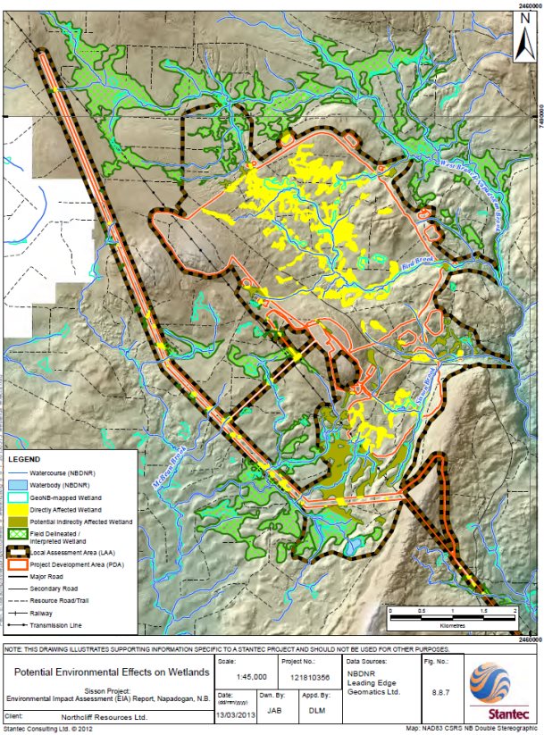
Source: Sisson Project Final Environmental Impact Assessment Report, Stantec Consulting Ltd.
The proponent committed to compensating for the direct loss of wetlands that are included in the Province of New Brunswick's GeoNB website (35.2 hectares) in accordance with the New Brunswick Wetlands Conservation Policy and to compensate for the loss of wetland function of field-identified wetlands (164.4 hectares) in accordance with the Federal Policy on Wetland Conservation (see below). It proposed to develop a Wetland Compensation Plan in consultation with the Government of New Brunswick and Environment and Climate Change Canada, which would be progressively implemented with Project phases and in response to the results of follow-up.
The proponent also committed to avoiding wetlands, where possible, and minimizing environmental effects on wetlands through the application of standard erosion and sedimentation control measures, implementation of dust control measures, and the treatment of water prior to release to the environment. Additional measures proposed by the proponent to mitigate impacts on wetlands are described in Appendix E.
The proponent predicted that wetland losses would not be substantive (less than 0.1 percent of wetlands in the regional assessment area).
The proponent predicted that the residual effects of the Project on the wetland environment would be low in magnitude, occur locally, occur once but be felt over the life of the Project, and be reversible. Taking into account the mitigation and follow-up measures proposed (Appendix E), the proponent concluded that the residual adverse effects of the Project on the wetland environment were unlikely to be significant. It stated that this conclusion was based on a moderate level of confidence given a lack of certainty about the extent of indirect wetland loss outside of the project development area.
Cumulative Environmental Effects
Cumulative environmental effects could result from the Project in combination with future forestry activities and agricultural land use. The proponent stated that future agricultural land use is not expected to act cumulatively with the Project as the project development area overlaps with 0.89 hectares of agricultural lands and there are no known planned agricultural developments in the local assessment area. Forestry activities and management on New Brunswick Crown lands is controlled by the Province of New Brunswick, which takes wetland management into account.
The proponent predicted that cumulative environmental effects on wetlands would be limited to minor, temporary changes to forested wetlands within the regional assessment area related to impacts of the Project in combination with forestry activities. When considering the proposed mitigation, and when taking into account the comparatively small loss of wetlands within the project development area compared to that available in the regional assessment area, the proponent predicted cumulative environmental effects are unlikely to be significant.
Monitoring and Follow-Up
The proponent stated that monitoring of wetlands directly affected by the project development area would occur as a part of the wetland compensation program. Compliance monitoring would be conducted to confirm the proper implementation of mitigation measures.
In addition, a follow-up program would be designed to assess indirect changes in GeoNB-mapped and field mapped wetlands within the local assessment area, targeting areas of likely effects (i.e. within the groundwater drawdown zone of the open pit and down-gradient of the tailings storage facility area). The program would assess the extent and nature of changes in wetland area and function outside of the project development area and be used to determine the need for further compensation and adaptive management.
5.7.2 Views Expressed
The public and Environment and Climate Change Canada commented on the proponent's wetland compensation commitments. The proponent initially committed to compensating for the direct loss of wetlands included in the Province of New Brunswick's GeoNB website. However, following comments from Environmental Canada, the proponent also agreed to compensate for the direct loss of wetland function of field-identified wetlands [17] (164.4 hectares) in accordance with the Federal Policy on Wetland Conservation.
Environment and Climate Change Canada recommended that the proponent compensate for forested wetlands, located within the corridor of the proposed transmission line, which would be deforested as a result of transmission line construction. Although these wetlands would remain vegetated, deforested wetlands would result in a substantial change to, or loss of, the wetland function. Environmental Canada noted that these forested wetlands provide habitat for three avian species at risk (i.e. Rusty Blackbird, Canada Warbler, Olive-sided Flycatcher) and that wetland losses in New Brunswick have reached critical levels. Environment and Climate Change Canada stated that it would consider the loss of forested wetlands within the transmission line corridor to be a significant environmental effect, unless losses were compensated.
The proponent disagreed with Environment and Climate Change Canada's assessment of effects from the deforestation of wetlands, stating that the forested wetlands are common in New Brunswick and that individual birds displaced as a result of the Project would likely find suitable nesting habitat nearby. Nonetheless, the proponent committed to compensating for the net loss of the function of all wetlands (i.e. GeoNB mapped and field-identified wetlands) affected by the Project, including wetlands along the transmission line. It agreed to work with Environment and Climate Change Canada and the Province of New Brunswick to develop and implement a Wetland Compensation Plan that would meet the requirements of the both the federal and provincial wetland policies. The Wetland Compensation Plan would address both direct losses of function within the project development area and indirect losses outside the project development area, as identified through the follow-up program. The plan would be progressively implemented with Project phases and in response to the follow-up results.
The Province of New Brunswick and Maliseet and Mi'gmag First Nations commented on the habitat value of wetlands. They stated that wetlands loss would result in the loss of plants of importance to First Nations. In response, the proponent provided supplemental information on plants important to First Nations to demonstrate that these are not unique to the Project site, but widespread on the surrounding Crown land. The proponent committed to considering the interests and knowledge of First Nations in preparing and implementing the Wetland Compensation Plan in ways that could support First Nations use activities.
The Province of New Brunswick reported that the Project would potentially result in the single largest direct loss of wetland area and/or impacts on function from a single project in New Brunswick. Through conditions of EIA approval, the Province of New Brunswick would require the proponent to develop a conceptual Wetlands Compensation Plan consistent with the Federal Policy on Wetland Conservation and New Brunswick Wetland Conservation Policy. The plan would take into consideration opportunities for wetland habitat restoration in proximity to the Project and include:
- additional baseline field data on habitat and functions;
- identification of all wetlands within the project local assessment area;
- an on-the-ground determination of total area of wetland that would be altered by the Project;
- a description of proposed compensation activities (i.e. restoration, enhancement, creation);
- detailed design of the proposed compensation projects;
- a schedule for implementing wetland compensation activities; and
- a monitoring program to track the success of compensation efforts.
In addition, the Province of New Brunswick confirmed that monitoring of wetlands beyond the footprint of the Project could result in additional compensation requirements in future, if a loss of wetland function beyond the initial development area occurs.
Environment and Climate Change Canada and the Province of New Brunswick have advised the Agency that the proposed mitigation measures and follow-up would adequately address the potential effects on the wetlands.
5.7.3 Agency Analysis and Conclusions
The Agency recognizes that the Project would result in the direct loss or alteration of approximately 215 hectares of wetlands in the mine area (200 hectares) and along the transmission line (15 hectares). In addition, indirect losses of wetlands could occur over the life of the Project through changes in drainage and local hydrology (e.g. from retention of surface water in the tailings storage facility), although there could be some reversal of these effects following decommissioning.
The Agency notes that the proponent will compensate for 215 hectares of wetland function that would be lost as a result of the Project in conjunction with the Federal Policy on Wetland Conservation and the New Brunswick Wetland Conservation Policy, particularly as some of these wetlands provide habitat for avian species at risk. In addition, it would be important that the proponent monitor, and compensate, for the indirect loss of wetlands and wetland function (e.g. through drawdown) in accordance with federal and provincial wetland policies. Monitoring results should be reported to the Province of New Brunswick and Environment and Climate Change Canada.
In addition to compensating for lost wetlands, the Agency believes that the proponent should minimize impacts to wetlands through measures, such as avoidance (when possible), erosion and sedimentation control, dust control, and treatment of water prior to release to the environment.
Taking into account the mitigation measures proposed by the proponent and required by the Province of New Brunswick (Appendix C), the Agency considers that the adverse residual effects of the Project on wetlands would be: low in magnitude, local in extent, and reversible. The effects could occur through all phase of the Project (e.g. on-going impacts on water quality). Taking into account applicable mitigation, the Agency is of the view that the Project is not likely to result in significant adverse environmental effects on wetlands.
5.8 Human Health
Description of Baseline Environment
The public and Maliseet and Mi'gmag First Nations use the project area for hunting, fishing, trapping, and recreational activities. Existing baseline concentrations of contaminants in groundwater, surface water, wild game, fish, and vegetation near the Project were found to be high in relation to accepted benchmarks [18], thus potentially contributing to risks to human health. The proponent collected data for contaminants of potential concern in air, soil, plants, water, invertebrates, small mammals, and fish. Baseline concentrations of chromium, cobalt, manganese, methyl mercury, and thallium exceeded accepted benchmarks for human health risks related to consumption of vegetation, wild game, and fish. In addition, baseline concentrations of various contaminants (e.g. aluminum, cadmium, iron, mercury, copper, zinc, arsenic, lead, manganese) and other water quality parameters (e.g. pH) in surface and groundwater occasionally exceeded benchmarks. Baseline water quality in the local assessment area is described in section 5.3.
5.8.1 Proponent's Assessment of Potential Environmental Effects and Mitigation
The proponent predicted that emissions and waste from the Project may release contaminants into the air, water, and soil and could have effects on human health either directly (i.e. via inhalation of airborne contaminants or ingestion of waterborne contaminants) or indirectly (i.e. through the consumption of contaminated foods).
Air
Project-related emissions of air contaminants may cause elevated health risks via inhalation of ground-level concentrations of these contaminants. The proponent predicted that health risks associated with inhalation exposures would be less than the established benchmarks (concentration ratio< 1.0)[19], with the exception of occasional short term (one-hour or 24-hour) exposures for total PM, aluminum, arsenic, and manganese. Maximum ground-level concentrations for these contaminants would occur near the boundary of the quarry and tailings storage facility. The proponent assumed there would be a low likelihood that any person would be present at the same place within the project development area and at the same time as the occurrence of the maximum ground-level concentrations.
Air emissions may result in dust deposition on soils and vegetation, which could potentially increase contaminant concentrations in soil, plants, and wild game. Based on the minimal changes in soil concentrations predicted by the Human Health Risk Assessment model after 27 years of operations, the proponent predicted that deposition of ore dust within the local assessment area would be negligible and therefore the potential for direct deposition of ore dust to affect plant concentrations would also be negligible. The proponent advised that measures to mitigate effects on the atmospheric environment (section 5.2) would also reduce effects on human health. Additional mitigation measures specific to human health were not proposed.
Water
Seepage and the release of treated mine contact water from the tailings storage facility (during operations) and surplus pit water (post-closure) have the potential to affect water quality in the receiving environment. Human health could be affected if the users of nearby recreational campsites collect surface water originating from springs. The proponent stated that these springs are likely a result of localized, shallow interflow from precipitation and are unlikely to be substantially affected by the Project. There are no other known users of surface or groundwater in the local assessment area for drinking water.
With the exception of ingestion of arsenic in surface water, the maximum health risks associated with a lifetime of exposure to predicted concentrations of contaminants in water from the Project are all less than the benchmarks [20]. Annual average arsenic concentrations meet the Guidelines for Canadian Drinking Water Quality of 0.010 milligrams per liter; however, the estimated lifetime cancer risk associated with the ingestion of drinking water containing arsenic at 0.010 milligrams per litre is greater than Health Canada's "essentially negligible" risk level. The proponent predicted that the maximum annual average concentration of arsenic in Napadogan Brook of 0.00455 milligrams per litre is unlikely to result in health effects since potential exposures to the water would be intermittent (i.e. no public water supplies and no residential wells within the local assessment area). It advised that measures to mitigate effects on water resources (section 5.3) would also reduce effects on human health; additional measures specific to human health were not proposed.
Country Foods Consumption
For the purpose of conducting a Human Health and Ecological Risk Assessment for the Project, the proponent assumed that First Nations, the mostly likely affected resource users, could be obtaining 100 percent of their game, 20 percent of their fish, and ten percent of their vegetation from the project area.
The proponent predicted that the Project is not expected to substantially affect the quality of game or vegetation in the local assessment area. It stated that health risks associated with project-related activities would be generally similar to baseline health risks, with the exception of those associated with predicted concentrations of arsenic, boron, cobalt, and thallium in fish tissue and arsenic in surface water. The human health risks associated with the contamination of fish tissue were predicted to be more than ten percent higher than the existing calculated health risk. However, a long-term change in health was not expected given: (1) the degree of conservatism, (2) the similarity of predicted fish tissue concentrations to those in reference locations or natural areas (elsewhere in Canada and North America), (3) that predicted levels would be in compliance with Canadian Guidelines for Chemical Contaminants and Toxins in Fish and Fish Products, and (4) the low to moderate level of risk.
The proponent predicted that the residual effects of the Project on human health would be low to medium in magnitude, occur locally, occur continuously over the life of the Project, and be irreversible. Taking into account the mitigation and follow-up measures proposed (Appendix E), the proponent concluded that the residual adverse effects of the Project on human health were unlikely to be significant. It made this conclusion with a moderate level of confidence, in view of some of the uncertainties associated with water quality predictions and the inherent conservatism in water quality, air quality, and Human Health and Ecological Risk Assessment modelling predictions.
Cumulative Environmental Effects
The proponent stated that there is potential for cumulative environmental effects on human health to occur primarily in association with future industrial land use, forestry, agriculture, and residential land use. These activities may release combustion gases or cause fugitive dust emissions which could be inhaled by the public (if they are present at the location of the elevated concentrations) and thereby potentially affect human health. The proponent determined that these future projects or activities were unlikely to result in significant cumulative environmental effects on public health since they would not be expected to cause a substantive change in the quality of air, surface water, or groundwater beyond existing background levels.
Monitoring and Follow-Up
Proposed monitoring and follow-up related to water resources (section 5.3) and fish and fish habitat (section 5.4) would be used to confirm effects predictions related to human health. These programs would also verify potential changes in trace metal concentrations in fish tissue.
Though the proponent predicted no significant environmental effects on traditional foods, it proposed to monitor potential effects at two to three traditional use sites identified by First Nations for harvesting of country foods (e.g. fiddleheads, berries, medicinal plants) prior to construction and within five years of operations.
5.8.2 Views Expressed
Health Canada, Maliseet and Mi'gmag First Nations, and the public requested that the proponent consider dust monitoring. Concerns related to the inhalation of PM (i.e. dust) were expressed. Health Canada recommended that the proponent consider all technologically and economically feasible measures to reduce PM. The proponent responded that it would employ standard measures to minimize emissions and thereby reduce effects on human health.
Maliseet and Mi'gmag First Nations raised concerns about dust generation along roads and requested that the proponent provide a plan to abate and mitigate related impacts. The proponent responded that road dust along unpaved roads is unlikely to affect vegetation quality, including edible berries, above background conditions. The proponent stated that maximum ground-level concentrations of total PM and PM10 could exceed the respective objectives or standards on occasion, as a result of fugitive dust emissions on forest resource roads during construction; however, the proponent predicted that exceedances would be localized, infrequent, brief, and that mitigation measures for the atmospheric environment would help address issues related to dust. Should complaints be received, the proponent committed to reviewing their validity and considering additional mitigation as necessary. As part of its conditions of EIA approval, the Province of New Brunswick would require the proponent to develop a Public Complaints Protocol, which would require the reporting of all complaints, corrective actions, and/or proponent response to complaints. Furthermore, the Province of New Brunswick would require the proponent to model and monitor air quality and to develop a Dust Suppression Plan as part of its Environmental Protection Plan.
Health Canada and the public asked the proponent to evaluate baseline and project-related emissions of PM10 to ensure that the predicted future concentrations are not underestimated. Health Canada recommended that the criterion for PM10 under the Ontario Ambient Air Quality Criteria be used for comparison to project emissions (50 micrograms per cubic meter for a 24-hour averaging period). The proponent responded that although significant adverse environmental effects from PM10 are unlikely to occur during construction, monitoring of ambient total PM would be carried out on or near the project site to confirm if concentrations at the nearest receptors are below the significance criteria. As part of its conditions of EIA approval, the Province of New Brunswick would require the proponent to conduct baseline air quality studies for PM10, H2S and NH3. Health Canada recommended that the proponent also establish baseline conditions to verify ambient concentration predictions for total PM, PM2.5, and SO2. In addition, the Province of New Brunswick would also require monitoring of ambient air quality (e.g. for PM, PM10, PM2.5, H2S, SO2, NH3 , and potentially other contaminants) during operations as part of its mine Certificate of Approval.
The proponent predicted minimal changes in soil concentrations beyond current levels after 27 years of operations, and also a negligible potential for direct deposition of ore dust to affect the concentration of contaminants in or on plants. Health Canada recommended that vegetation consumed by the public and First Nations (e.g. fiddleheads and berries) be resampled at the onset of operations to verify baseline values of arsenic, chromium, manganese, and thallium to confirm estimations and assumptions presented in the Human Health and Ecological Risk Assessment conducted by the proponent. It also recommended that the proponent post signs in areas where edible vegetation is expected to be collected to warn people to avoid collecting vegetation or to wash vegetation prior to consumption. In addition, should it be determined that country foods are compromised as a result of the Project, the proponent should also post signs warning people to temporarily avoid collecting vegetation in applicable areas until the issue is resolved.
As part of its conditions of EIA approval, the Province of New Brunswick would require the proponent to undertake soil sampling and collect additional baseline (pre-construction) surveys of traditional country food. The surveys would be developed with input from First Nations and include foods that are trapped, fished, hunted, harvested or grown for subsistence or medicinal purposes or obtained from recreational activities (e.g. sport fishing, hunting) within the local assessment area. Foods used by First Nations would be monitored for metals (e.g. arsenic, chromium, manganese, thallium) to confirm predictions and assumptions used in the Human Health and Ecological Risk Assessment. Resulting baseline information would be used to develop a traditional and country foods monitoring program. The Province of New Brunswick would also require the proponent to conduct additional modelling of dust deposition on vegetation to be used in the traditional and country foods monitoring program to verify the revised predictions and ensure the protection of human health.
Maliseet and Mi'gmag First Nations, the public, and government raised concerns regarding the Project's effects on human health as a result of ingestion of contaminated drinking water or consumption of fish tissue with elevated concentrations of metals or other contaminants. Health Canada requested more information on the evaluation of potential effects on groundwater. It recommended that the proponent confirm nearby drinking water sources and, if they exist, collect baseline samples and sample them during operations to confirm that that there are no adverse effects on drinking water quality. The proponent stated that groundwater was not currently used as a potable supply in the vicinity of the tailings storage facility and that quarterly sampling would be conducted to verify that groundwater quality down-gradient of the tailings storage facility would remain below ranges predicted by the predictive water quality model. Should monitoring indicate that water quality parameters exceed predictions; further mitigation would be applied (section 5.3).
Health Canada, Maliseet and Mi'gmag First Nations, and the public questioned the exclusion of arsenic from the non-carcinogenic risk evaluation and speciation of arsenic in fish tissue. The proponent stated that for this assessment, which assumes a lifetime of exposure for people in local assessment area, the use of the carcinogenic endpoint and associated Toxicity Reference Values are the most conservative means for assessing the potential health effects from arsenic exposure.
With respect to arsenic, the predicted changes in surface water concentrations are substantive. However, the proponent indicated that mitigation measures would be employed to reduce metal loadings in streams, including: the collection and treatment of surplus mine contact water before discharge, and engineered drainage channels to collect seepage. The proponent concluded that increased arsenic concentrations would not result in health effects as local surface waters (i.e. Napadogan Brook) are not used as a regular source of drinking water.
Maliseet and Mi'gmag First Nations asked about potential health risks associated with boron, and questioned the proponent's conclusion that exposure to boron in food would not likely result in a substantive health risk. They requested that mitigation to specifically address increases in surface water concentrations of boron and potential increased boron concentrations in fish tissue. The proponent responded that conservative assumptions were incorporated into the Human Health and Ecological Risk Assessment, which resulted in risk estimates being consistently overstated. It believed that mitigation and monitoring associated with water quality and fish and fish habitat would be sufficient to discern and effects of trace metals on human health. The proponent indicated that further monitoring of metals in other media and biota could be considered if water quality and aquatic environment monitoring results were to indicate potentially unacceptable human health risks.
As part of part of conditions of EIA approval, the Province of New Brunswick would require the proponent to undertake pre-construction surveys to establish baseline conditions (i.e. water quality and quantity) for all water supplies within the local assessment area, including at camp lot lease sites and recreational campsites. Baseline results would be submitted for review and approval prior to construction and a copy of individual results provided to landowners and/or leasees. In the event of complaints related to water supply (quality or quantity), the proponent would be required to immediately investigate and mitigate as required if project activities were implicated.
To further mitigate potential effects on human health resulting from changes in water quality, the Province of New Brunswick stated that it would establish specific water quality objectives with which the proponent would be required to comply. The starting point for establishing water quality objectives would be the Canadian Water Quality Guidelines for the Protection of Aquatic Life (Freshwater). Where necessary, site specific water objectives would consider the most sensitive water uses, including human consumption (section 5.3).
Game/Fish/Country Food Consumption
Health Canada and Maliseet and Mi'gmag First Nations asked about baseline concentrations of potential contaminants in fish, wildlife, and vegetation, and expressed concern about the number of samples collected. Health Canada recommended that collection and analysis of country foods follow the Supplemental Guidance on Human Health Risk Assessment for Country Foods found in Federal Contaminated Site Risk Assessment in Canada.
Health Canada requested that the proponent include a small mammal sampling program in its Human Health and Ecological Risk Assessment and evaluate changes to the baseline data. Environment and Climate Change Canada recommended that the proponent commit to follow-up studies of metal concentrations in wildlife species important to resource users and First Nations. The proponent stated that the health risk for terrestrial ecological receptors was generally negligible, and that no further monitoring was warranted.
The proponent stated that the most substantive changes in predicted health risk for both human and ecological receptors would stem from predicted changes in surface water quality (caused in part by seepage into groundwater) and related changes in fish tissue concentrations. It anticipated that the follow-up and monitoring proposed in relation to groundwater, surface water, and fish tissue would discern emergent issues related to effects of trace metals on species. In the event that proposed monitoring was to indicate unacceptable levels of trace metals, metal monitoring in other media and biota could be considered.
Maliseet and Mi'gmag First Nations raised concerns about contaminant concentrations in locations where traditional land and resource use activities occur, and traditional foods are harvested and collected. Maliseet and Mi'gmag First Nations proposed a comprehensive monitoring program that would include:
- further sampling within a 400 square kilometer study area to improve knowledge of baseline concentrations of metals in soil types;
- monitoring a suite of resources important to Maliseet and Mi'gmag First Nations (e.g. vegetation, fish, wildlife, and water);
- adaptive management (in the event that increases in contaminant concentrations are identified);
- highlighting the results of arsenic in fish tissue to enable the assessment of the site-specific health risks; and
- analyzing fish tissue samples for total mercury and methyl mercury, with input on sample locations from Maliseet and Mi'gmag First Nations.
As a condition of EIA approval, the Province of New Brunswick would require the proponent, with input from First Nations, to undertake soil sampling and collect additional baseline information for country foods within the local assessment area, including small mammals. Baseline surveys would be used to develop a traditional and country foods monitoring program to be undertaken during project operations and decommissioning/post-closure. The survey and monitoring programs would be developed in consultation with First Nations, stakeholders, and appropriate regulatory agencies. Foods would be monitored (e.g. for arsenic, chromium, manganese, thallium) to confirm predictions and assumptions in the Human Health and Ecological Risk Assessment. Maliseet and Mi'gmag First Nations requested that data collected with respect to country food, air quality, and water quality be shared with their appropriate representatives.
The Province of New Brunswick would require the proponent to implement a reporting system and procedure in the event that complaints regarding the quality or taste of traditional or country foods were received. Complaints would be handled through the Public Complaints Protocol, and could be responded to by sampling the reported food for contaminants of potential concern (primarily metals). Results would be compared to: baseline data (if available); predicted values in the Human Health and Ecological Risk Assessment; and applicable health-based criteria. Further mitigation measures would be required should monitoring indicate increased contaminant concentrations.
The proponent has committed to monitoring potential effects on traditional use sites for harvesting of country foods before construction and again within five years of the start of operations. Health Canada advised that additional sampling may be required if conditions change and/or results justify this addition monitoring. Mi'gmag First Nations also expressed concern with respect to the five year timeframe chosen by the proponent to monitor potential effects on traditional use sites for harvesting of country foods.
Health Canada and the Province of New Brunswick have advised the Agency that the proposed mitigation measures and follow-up would adequately address the potential effects on the human health.
5.8.3 Agency Conclusions on the Significance of the Residual Environmental Effects
The Agency accepts that Project-induced changes to the atmospheric environment and water resources would not be expected to have adverse health effects on the population of Napadogan or other nearby communities. However, individuals intermittently using the project area for hunting, fishing, trapping, and other activities may be exposed to elevated levels of contaminants in the atmosphere, drinking water, or in harvested foods.
Exposure to contaminants through ingestion of fish tissue would result in elevated human health risks, but concentrations of these contaminants would meet the Canadian Guidelines for Chemical Contaminants and Toxins in Fish and Fish Products, and the predictions and benchmarks carry a degree of conservatism. The Agency notes that potential exposure to arsenic contamination from water would be intermittent as there are no known public water supplies or residential wells that would be affected or if monitoring indicates that there has been an impact, there is adequate mitigation proposed to off-set any adverse effects.
The Agency accepts Health Canada's recommendation that the proponent should undertake a pre-construction evaluation of the non-carcinogenic effects of carcinogens (e.g. arsenic) and include this in risk calculations for different receptors. As part of this program, results would be reviewed by Health Canada and provided to the Province of New Brunswick. These results would be used to determine baseline health risks and to inform water and air quality management. If changes in health risks are identified during operations through monitoring, any increased health risk would be compared to the baseline to determine if consumption advisories would be recommended.
While Maliseet and Mi'gmag First Nations expressed concerns in relation to impacts on country foods, the Agency is aware that the Province of New Brunswick would require additional collection of applicable baseline data and the implementation of a traditional and country foods monitoring program and reporting system. Further mitigation would be required should monitoring indicate increased contaminant concentrations.
The Agency accepts Health Canada's recommendation that the proponent post signs in areas where edible vegetation is expected to be collected to warn people to avoid collecting vegetation or to wash vegetation prior to consumption. In addition, should it be determined that country foods are compromised as a result of the Project, the Agency also recommends that signs be posted warning people to temporarily avoid collecting vegetation in applicable areas until the issue is resolved.
Taking into account the mitigation measures proposed by the proponent, required by the Province of New Brunswick (Appendix C), and recommended by Health Canada, the Agency considers that the adverse residual effects of the Project on human health would be: low in magnitude, limited in extent, and could occur through all phase of the Project (e.g. on-going impacts on water quality). Taking into account applicable mitigation, the Agency is of the view that the Project is not likely to result in significant adverse environmental effects on human health.
5.9 Land and Resource Use
The Project is located on forested Crown land primarily used for forestry and recreation. Forestry roads and trails are used informally for snowmobiling, all-terrain vehicles, hiking, and other recreational and resource use activities. Hunting and trapping also occurs in the vicinity of the Project and throughout the local assessment area by residents of surrounding communities and by tourists through the services of local guides and outfitters. There is no commercial fishery in the local assessment area nor open season for Atlantic Salmon in the Nashwaak River watershed; however, there is recreational and subsistence fishing, particularly for Brook Trout. The effects of the Project on the current use of lands and resources for traditional purposes by Aboriginal peoples are discussed in section 5.10.
The closest communities to the mine are Napadogan (10 kilometers), Juniper (20 kilometers), Millville (25 kilometers), and Stanley (23 kilometers). Approximately 39 recreational campsite leases, some of which include cabins, are located in the vicinity of the Project, the closest being 1.5 kilometers southeast of the proposed open pit on the other side of a topographical ridge (Nashwaak Ridge). Campsites are used throughout the year. A second cluster of New Brunswick recreational campsite leases is located on either side of the proposed transmission line, about four kilometers south of the Nashwaak River (Figure 5.3).
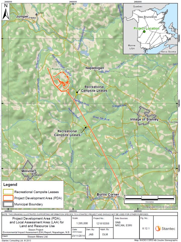
Source: Sisson Project Final Environmental Impact Assessment Report, Stantec Consulting Ltd.
5.9.1 Proponent's Assessment of Potential Environmental Effects and Mitigation
The Project would change the predominant land use within the project development area from forestry to industrial mining and mineral processing. As a result of the Project, approximately 1,442 hectares of land would become temporarily or permanently inaccessible for recreational use. In addition, individuals may choose to avoid a portion of the local assessment area due to perceived environmental, aesthetic, or safety concerns. Tourists using the portions of the project development area through the services of outfitters or guides would also be displaced. Overall, the proponent stated that surrounding land has the capacity to accommodate any recreational land use displaced by the Project, and that this displacement is not predicted to result in overcrowding in other areas. In addition, it stated that similar lands and resources are abundant throughout the regional assessment area.
Air quality
The proponent predicted that the Project would result in few short-term, intermittent exceedances of PM and PM10 objectives along off-site access roads (i.e. on forest and resource roads) during construction and operations (section 5.2). However, dust from the Project is predicted to be below the applicable objectives and standards at the nearest residences and recreational campsites. The proponent predicted that general construction noise would not be audible at recreational campsites nearest the Project. Blasting may be audible at the nearest recreational cabins; however, the proponent stated that due to the infrequent and very short-term nature of blasting noise (approximately two seconds at a time occurring approximately every two or three days), annoyance would be low. Sound pressure levels at the nearest residential receptors in Napadogan during blasting events are unlikely to be audible over existing background noise. Vibration from blasting is predicted to be noticeable at the nearest recreational campsites, but well below the significance criterion. The proponent committed to notifying local recreational campsite owners and land owners about the project schedule and the timing of blasting events to minimize surprise and nuisance. In addition, it committed to mitigation described in section 5.2 to reduce nuisance noise and air emissions.
Viewshed
The Project would not be visible from the nearby recreational campsites, because of a local ridge nor from any permanent residence. Trees and other vegetation would obscure the line of sight from many locations within the viewshed, hiding the Project from view. However, the Project could be visible from many locations within a few kilometers of the project development area. Project features would not be expected to be visible from the top of Crabbe Mountain of the Miramichi Lake environmentally significant area. Where possible (i.e. along cleared right-of-ways), trees and other vegetation would be left in place or encouraged to grow to obstruct the view of the Project, reducing changes in the viewshed and muffling noise.
Timber
The Project would result in the direct loss of 1,189 hectares of forested Crown land. Approximately 14.4 percent (or 171 hectares) of this recently-harvested forested that would not be part of forest harvesting plans for close to an entire harvesting cycle (i.e. 60 to 80 years). Loss of the area from active management for timber values has the potential to indirectly affect the vegetation community elsewhere in the license area by forcing licensees to alter harvest plans to compensate for the newly non-productive area within the project development area. The proponent anticipated that forestry management plans would be revised to incorporate the harvesting of forestry resources in the project development area as part of site preparation. The proponent predicted that, given the relatively small size of the project development area, its loss for timber harvesting would not likely result in a substantive economic change for local forestry companies.
Roads - Access
Project-related traffic during operations would include trucking, maintenance vehicles, and passenger vehicles. Traffic volumes along primary and secondary access routes, which are currently forestry roads, would increase over current levels and potentially affect the usability and condition of these routes. Project-related traffic would use the existing provincial highway transportation network and existing forest resource roads to access the Project site. The proponent stated that the roads are under-used and are more than able to accommodate the limited increased traffic that would arise from the Project, with some refurbishment as necessary. The improvement of forest roads would allow for better and easier access to the local assessment area, including the recreational cabins.
Water, Wildlife, and Fish
The proponent predicted that the availability and sustainability of resources (e.g. fish and fish habitat, wildlife) in the general project area would not be substantively affected by the Project and would continue to be available for use (i.e. by campers, fishers, hunters etc.). Mitigation to reduce impacts on water, fish and wildlife are discussed in sections 5.3, 5.4 and 5.5 of this Report.
Overall, the proponent predicted that the residual effects of the Project on land and resource use would be low in magnitude, occur locally, occur continuously over the life of the Project, and be reversible. Taking into account the mitigation and follow-up measures proposed (Appendix E), the proponent concluded that the residual adverse effects of the Project on land and resource use were unlikely to be significant.
Cumulative Environmental Effects
The proponent assessed potential cumulative effects on land and resources for present and future industrial use, forestry and agriculture use, current use of land for traditional purposes by Aboriginal peoples, and recreational uses as well as planned residential development. Its analysis concluded that there was a potential for cumulative effects on future forestry and agricultural use and on planned residential development. According to the proponent, forestry, in particular, has shaped the landscape in much of the regional assessment area and will continue to do so in the future. The proponent predicted that cumulative effects on land use would not be significant, because forestry activities are subject to extensive forest management plans and objectives that are reviewed frequently. Despite being identified as an area of potential cumulative effects, the analysis for planned residential development did not identify adverse environmental effects. Overall, the proponent predicted that cumulative environmental effects of the Project in combination with other projects or activities were unlikely to be significant.
Monitoring and Follow-Up
The proponent did not propose follow-up or monitoring to verify effects predictions or the effectiveness of mitigation related to land use.
5.9.2 Views Expressed
Vehicle Traffic
The Province of New Brunswick asked about vehicle traffic from the Project and potential impacts on First Nations, the public, and camp lot lessees. The proponent responded that the Project would generate up to 136 vehicle trips per day (one-way) to and from the mine site during construction and up to 228 vehicle trips per day (one way) during operations; adding little to existing traffic on those roads. It stated that the Project was not expected to contribute adversely to road transportation infrastructure or traffic levels in the local assessment area, and consequently adverse impacts on the public, First Nations, or other parties (e.g. hunters, camp lessees) were not expected to occur.
Dust
The public requested more information about dust dispersion and potential impacts on residences, forest resource, and public roads. The proponent predicted that dust levels would not exceed air quality objectives at nearby camp sites, residences, or along or near existing forest resource roads or public roads. Impacts on air quality are discussed in section 5.2.
Groundwater
The public asked about potential effects on the use of groundwater and the Nashwaak River as potable water sources for future development. The proponent responded that the Project would not limit the use of groundwater or the Nashwaak River as potable water, nor would it limit water resources available for potential future development outside the project development area.
The Province of New Brunswick commented on potential effects on the water table, and on drilled wells in the Napadogon Brook area that could be caused by dewatering of the open pit. The proponent stated that recreational campsites are located outside of the two kilometer zone where possible drawdown associated effects are predicted, and these campsites appear to be relying on shallow groundwater draining the east side of Napadogan Ridge (to be confirmed prior to construction). Therefore, water supplies at the recreational campsites are not predicted to be affected by drawdown from dewatering the open pit.
The Province of New Brunswick asked about the fresh water requirements of the Project (i.e. five to ten groundwater supply wells would be required to provide 21 cubic meters per hour). It cautioned that, a water supply source assessment would be required (following EIA approval) and the proponent would be required to look at other options, if it were to be determined that there was inadequate water supply. The Province of New Brunswick further advised that should the Project negatively impact the quality and/or quantity of local water supplies (i.e. dug wells and drilled wells), it would be required to provide temporary water as a short-term solution or remediate the water supply (i.e. water treatment, deepening a well, drilling a new well) as a longer term solution.
As a condition of EIA approval, the Province of New Brunswick would require the proponent to conduct a pre-construction survey to establish baseline conditions (water quality and quantity) for all water supplies within the local assessment area, including camp lot lease sites and recreational campsites. The proponent would be required to investigate complaints and mitigate as specified by the Province of New Brunswick. In addition, a Water Monitoring/Management Plan, including monitoring for groundwater would be required by the Province of New Brunswick. Further discussion of drinking water quality and quantity is included in sections 5.3 and 5.8.
Access
The Province of New Brunswick asked about access to Crown lands and camp lots being impacted should existing forest roads be abandoned or affected. The proponent responded that the Project would not cause the abandonment of access roads to recreational lease sites, and access to camp sites would not be prevented.
The Province of New Brunswick noted that the proponent's conclusion that the public would relocate to other Crown lands for recreational purposes was unsubstantiated, and requested the proponent implement specific mitigation to address loss of use of the area around the Project. The proponent stated that the project development area occupies only a small portion of the two Crown timber licenses, and the loss of this area was expected to be manageable within the existing Crown timber management process without substantive modification to forest harvesting plans. Furthermore, the proponent believed that no aspects of the local assessment area are unique, and similar lands and resources are abundant throughout the regional assessment area (i.e. central New Brunswick has vast expanses of remote, forested Crown lands similar to those in the project development area). As a condition of EIA approval, the Province of New Brunswick would require the proponent to compensate for relocation of existing individuals or community camp sites within the project development area and within the local assessment area on Crown land should the Project impact use of camp sites.
The Province of New Brunswick advised the Agency that the proposed mitigation measures and follow-up would adequately address the potential effects on the land and resource use.
5.9.3 Agency Analysis and Conclusions
The Agency recognizes that the forested Crown land on which the Project would be developed would become inaccessible for forestry and recreational use. In total, approximately 1,442 hectares of land would be affected, and the Agency considers this loss an unavoidable environmental effect of the Project. Additional effects on land and resource use in other areas of the local assessment area may occur as a result of impacts on water resources, the atmospheric environment, wetlands, human health, terrestrial wildlife, fish and fish habitat, and the vegetated environment.
Although the Project is not predicted to the visible from nearby recreational campsites, permanent residences, or Crabbe Mountain, it could be visible from many locations within a few kilometers of the project development area. Trees and other vegetation would obscure the line of sight from many locations within the viewshed, hiding the Project from view. It would be important for the proponent to leave in place or re-establish trees and other vegetation where possible (i.e. along cleared right-of-ways) to reduce change in the viewshed and muffle noise.
Mitigation in relation to biophysical component is expected to likewise mitigate effects on land and resource use. Taking into account the mitigation measures proposed by the proponent and required by the Province of New Brunswick (Appendix C), the Agency considers the adverse residual effects of the Project on land and resource use would be: moderate in magnitude; contained predominately within the local assessment area; long-term in duration; continuous; and partially reversible. Taking into account applicable mitigation, the Agency is of the view that the Project is not likely to result in significant adverse environmental effects on land and resource use.
5.10 Current Use of Lands and Resources for Traditional Purposes by Aboriginal Persons
The Project is located in a rural, undeveloped area on provincial Crown land within the Nashwaak River watershed. Maliseet First Nations have indicated that the Project is within their traditional territory. The Maliseet communities of St. Mary's, Kingsclear and Woodstock First Nations are in closest proximity (within 50 kilometres) to the Project. Mi'gmag First Nations in New Brunswick also use the land and resources in and around the Project for traditional purposes.
First Nations people use the project area for traditional activities to support their culture and livelihood. Current uses of lands and resources for traditional purposes occurring in the area include hunting, fishing, gathering (e.g. berries, medicinal plants), and timber harvesting. First Nations groups (St. Mary's, Kingsclear, Woodstock, and Tobique) identified the Project footprint and surrounding five kilometer radius as valuable in enabling continued current uses of lands and resources for traditional practices due to the following key characteristics:
- a high level of quality, quantity, and diversity of resources;
- accessibility, including a reasonable travelling distance from home;
- little to no competition with non-Indigenous land users for resources in the area;
- a large and intact piece of Crown land;
- an area that was introduced to them by their elders;
- provides peace and quiet;
- presence of members' camps; and
- clean drinking water sources.
5.10.1 Proponent's Assessment of Potential Environmental Effects and Mitigation
The proponent assessed the effects of the Project on the current use of lands and resources for traditional purposes by Aboriginal peoples by funding and considering an indigenous knowledge study that included participants from three Maliseet communities: St. Mary's, Woodstock and Madawaska First Nations. In addition, the proponent used the First Nation Environmental Assessment Working Group to collect information on current use. This group included representation from all Maliseet and Mi'gmag communities in New Brunswick, as well as the provincial and federal governments.
The study areas used by the proponent to conduct the assessment are defined and illustrated in Table 5.7 and Figure 5.4 respectively. The study areas defined in the Indigenous Knowledge Study are also set out in Table 5.7.
|
Proponent's Definition |
Indigenous Knowledge Study Definition |
|---|---|
|
project development area: physical project footprint (1253 hectares) |
project footprint: physical project footprint (Same as the proponent' definitions (1253 hectares) |
|
local assessment area: project zone of influence - project footprint and adjacent areas to which access would be restricted (1,442 hectares) |
project area: project footprint plus the area of traditional use potentially affected by the Project, approximately five kilometers around the project footprint (Approximately 10,000 hectares). |
|
regional assessment area: portion of the St. John River watershed that lies within New Brunswick, which is generally thought to represent the traditional territory of the Wolastoqiyik (Maliseet) (890,200 hectares of Crown land) |
regional study area: block of Crown land surrounding the project footprint (64,500 hectares) |
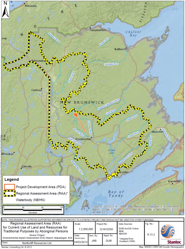
Source: Sisson Project Final Environmental Impact Assessment Report, Stantec Consulting Ltd.
Resources - Traditional Hunting, Fishing and Gathering
Species hunted by the Maliseet in the project area include moose, deer, partridge, woodcock, and rabbit. Trout and salmon are the key fish species of importance to First Nations. The Project Area also includes several tree and plant species that are used for medicinal and food purposes. Additionally, timber is harvested in the area and used for crafts, firewood, furniture making and wreath making.
The proponent carried out an analysis of effects of the Project on the biophysical valued components that relate to the current use of lands and resources by Aboriginal people, such as water resources, fish and fish habitat, terrestrial wildlife and habitat, vegetated environment, and wetland environment. The proponent determined that terrestrial wildlife and fish important to First Nations could be affected by the loss or fragmentation of habitat, as well as by direct mortality as an accidental event. Vegetation clearing for the mine and the transmission line and dust deposition or other indirect effects could affect plant resources valued by First Nations.
Access to Land and Resources
In the Indigenous Knowledge Study, First Nations identified the land on which the Project would be situated as part of one of the largest contiguous pieces of Crown land located in closest proximity (within 50 kilometers) to St. Mary's, Kingsclear, and Woodstock First Nations. The proponent determined that the Project may affect the ability of First Nations to access the lands and resources in the local assessment area to carry out traditional activities. The change in quantity of land available and the duration of the change were measurable parameters identified by the proponent for determining a significant effect on current use. Specifically, the proponent defined a significant effect on current use of lands and resources by Aboriginal people as:
A significant adverse residual environmental effect on Current Use of Land and Resources for Traditional Purposes by Aboriginal Persons is defined as a long-term (more than 1 year) loss of the availability of, or access to, land and resources for use by Aboriginal persons for traditional purposes within the assessment area that cannot be mitigated. This includes an environmental effect that results in a long-term (more than 1 year) loss of the availability of, or access to, water resources, the aquatic environment, the terrestrial environment, the vegetated environment, the wetland environment, and heritage resources located within the assessment area that cannot be mitigated.
The proponent's assessment area includes the project development area, local assessment area and regional assessment area, the latter of which comprises the Saint John River Valley (Figures 5.4 and 5.5). The proponent states that this boundary is generally thought to represent the entirety of Maliseet traditional territory that is contained in New Brunswick.
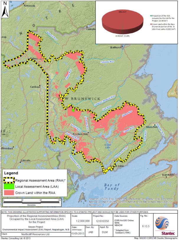
Source: Sisson Project Final Environmental Impact Assessment Report, Stantec Consulting Ltd.
The proponent stated that there would be no access to, or resource use permitted in, the local assessment area, which totals 1446 hectares, for the duration of the Project. However, it predicted that traditional activities (e.g. hunting, fishing, and gathering) would not be hindered by a lack of access to traditional resources in the local assessment area since First Nations would continue to have access to, and use of, the land and any resources present in the large area of Crown land outside of the local assessment area. Overall, the proponent stated that the geographic extent of land and resources that would be used by the Project (i.e. the local assessment area) is small compared to the larger asserted Maliseet traditional territory, represented by the regional assessment area (Figure 5.5).
Rehabilitation of the land on which the mine buildings would be located would occur after Project decommissioning to a state that it would support wildlife. However, for most of the site, reclamation to a state that supports the use of lands and resources for traditional purposes would not be possible. The mine pit and tailings impoundment areas would become permanent water features and the steep slopes of the pit and quarry would present a safety concern for access. In these areas, loss of access to, and use of, land for hunting and gathering would be permanent and irreversible.
Sensory Disturbance
Outside of the local assessment area, First Nations fish in Mud Lake, Napadogan Brook and its tributaries, Sisson Brook, and the Nashwaak River and its tributaries. Members of St. Mary's First Nation have camps in the area, including a community camp, located approximately 1.5 kilometers from the Project. The Indigenous Knowledge Study stated that this camp is used as a staging area for hunting, fishing, and gathering. Brooks serve as a source of drinking water when camps are being used and traditional activities are being undertaken. In its analysis of impacts on water quality (section 5.3), the proponent noted that project discharges and tailings seepage may result in some exceedances of water quality guidelines in waterbodies outside the local assessment area , these exceedances are not expected to result in an environmental or human health risk.
As described in section 5.2, the proponent predicted that increases in dust from road traffic in areas outside the local assessment area would be mitigated and would not pose a health risk or result in unacceptable change in visibility. The proponent indicated that blasting would be audible but brief and vibration amplitude small at recreational camp sites. Also as noted in section 5.9, the proponent indicated that the tailings storage facility and the open pit would be visible up to a few kilometers from the Project, depending on topography and direction, but would have minimal effects on recreational campsites or residential areas. The areas in which blasting, vibration, and visual landscape changes would be noticeable include St. Mary's First Nation's communal camp and the area identified in the Indigenous Knowledge Study as being used by St. Mary's, Woodstock, and Madawaska First Nations members for traditional practices.
Mitigation Measures
In addition to mitigation associated with other valued components (Appendix E), the proponent also committed to the following measures specific to current use:
- developing sustainable, economically viable and responsible management and reclamation plans for the Project in consultation with First Nations.
- providing the opportunity to harvest resources used for traditional purposes in the project development area prior to site preparation activities, where reasonable and within the timeframe of planned activities; and
- reclaiming land in the areas occupied by buildings and infrastructure to ensure its accessibility for traditional purposes following closure of the Project.
The proponent indicated that the Province of New Brunswick would revise forestry management plans to incorporate the harvesting of forestry resources in the project development area. In addition, the proponent would provide information to Crown licensees in advance of construction to facilitate planning in collaboration with the Province of New Brunswick (Department of Natural Resources).
Predicted Residual Effects
The proponent predicted that the residual effects of the Project on the current use of lands and resources for traditional purposes by Aboriginal peoples would be low in magnitude, occur within the project development area, occur continuously over the life of the Project, and be irreversible. Direct loss of the project development area would be unavoidable; however, the proponent predicted this loss would not cause a significant effect on the current use of lands and resources for traditional purposes due to the availability of other Crown land within the regional assessment area with similar biophysical resources, and mitigation measures it proposed for biophysical valued components and the current use of lands and resources for traditional purposes. Taking into account these and other mitigation and follow-up measures proposed (Appendix E), the proponent concluded that the residual adverse effects of the Project on the current use of lands and resources for traditional purposes by Aboriginal peoples were unlikely to be significant.
Cumulative Environmental Effects
The proponent stated that since there are no expected significant environmental effects of the Project on the current use of land and resources for traditional purposes by Aboriginal persons within the defined assessment area, and the management of Crown land is undertaken in a way that reflects and mitigates the interests of First Nations, it follows that the overlapping environmental effects of the Project in combination with other projects or activities that have been or will be carried out are mitigated such that they are not significant. As such, the potential residual cumulative environmental effects of the Project in combination with other projects or activities that has been or will be carried out on current use of land and resources for traditional purposes by Aboriginal persons during all project phases are rated not significant. This determination was made with a high level of confidence.
Monitoring and Follow up
In addition to the follow-up measures proposed in relation to the biophysical valued components, the proponent committed to working with First Nations on monitoring and follow-up programs. The proponent concluded that a program specific to the current use of lands and resources by Aboriginal peoples was not required since its conclusions were made with a high degree of confidence. However, the proponent committed to working with First Nations to identify two to three sites of local importance to those who harvest country foods and to collect samples of select species (e.g. fiddleheads, berries, medicinal plants) in order to verify predictions that there would be no human health risk to consuming country foods. The proponent also indicated that as a user of Crown land, it would cooperate with other parties to manage cumulative environmental effects arising from the Project by supporting a broader study of the sustainability of traditional activities by First Nations in the Crown land block.
5.10.2 Views Expressed
Provincial and Federal Authorities
The Province of New Brunswick's General Review Statement on the Project (April 2015) concluded that despite the proposed mitigation, residual environmental effects on current use of lands and resources for traditional purposes would occur, and recommended that government consider appropriate accommodation to offset any residual effects. The Province of New Brunswick also recommended that additional follow up and monitoring requirements be imposed. Consequently, as part of its conditions of EIA approval, the Province of New Brunswick would require the proponent to conduct additional baseline (pre-construction) surveys of traditional country foods, which would include foods that are trapped, fished, hunted, harvested or grown for subsistence or medicinal purposes or obtained from recreational activities such as sport fishing and/or game hunting within the local assessment area. The baseline information would then be used to develop a traditional and country foods monitoring program to be undertaken during operations and decommissioning/post-closure.
Environment and Climate Change Canada and the Agency recommended that the proponent expand the local assessment area within which impacts of the Project on the current use of land and resources for traditional purposes by Aboriginal people were assessed. A larger assessment area would reflect not only direct loss of physical access to the project development area and adjacent exclusion zones, but also areas adjacent and downstream potentially affected by the Project's residual effects (i.e. noise, water quality, air quality, habitat disruption and project visibility). It was recommended that the proponent seek input from First Nations on recommended changes to the local assessment area boundary. In addition, Environment and Climate Change Canada recommended that the proponent consult First Nations on whether the proponent's regional assessment area boundary should be redefined to reflect information from the Indigenous Knowledge Study. Maliseet and Mi'gmag First Nations stated that the size of the regional assessment area does not recognize that land within this area is not of equal value for traditional land and resource use, and dilutes First Nation preferred use areas. Maliseet and Mi'gmag First Nations suggested that the Crown land block within which the Project would be located would be a more appropriate regional assessment area.
The proponent stated that the local assessment area was defined with consideration of the land and resources that would no longer be available to Indigenous peoples once the Project was carried out (i.e. the direct zone of influence of the Project). Adjacent land outside the project development area and restricted access zone would continue to be available for use, and as such are not part of the zone of influence of the Project. In addition, proponent stated that the Saint John watershed was an appropriate regional assessment area to support the assessment of cumulative environmental effects. It did not consider the broader Crown land block as an appropriate study area as it does not represent the extent of Maliseet territory in the Province of New Brunswick within which First Nations have rights. Moreover, the proponent stated that a change in boundary would not change the prediction that environmental effects on current use are not expected to extend substantively beyond the exclusion zone, and by extension, the pursuit of current use activities would be similarly unaffected.
First Nation Communities
A summary of comments provided by Maliseet and Mi'gmag First Nations during the environmental assessment is provided in Appendix H. Select comments in relation to specific valued components are included in applicable sections of this Report .
St. Mary's First Nation, located within the City of Fredericton (1729 members) stated that the local assessment area covers an area of preferred resource use, in close proximity to the community and has historical significance (e.g. a portage route between the Miramichi River system and the Nashwaak River system exists within the project area as defined in the traditional knowledge study). The community uses the local assessment area to hunt moose, harvest traditional foods, and gather medicinal plants and wood. The moose hunted in the area are shared within the community with elders and others unable to hunt for themselves. St. Mary's First Nation estimated that approximately 40 members are gathering and sharing traditional food from the site and surrounding area. Further it stated that the local assessment area is a teaching area used to pass knowledge about traditional land use from one generation to another and is valued as a spiritual area known to First Nations as being productive and peaceful.
St. Mary's First Nation advised that in addition to the loss of access to the local assessment area, areas surrounding the local assessment area would be unsuitable for the practice of traditional uses as a result of residual Project effects on water and other resources. Dust, noise, light and visibility of the Project would deter members from using a larger area than predicted by the proponent. The community asserted that changes in use would have lasting effects at a nation-scale and disrupt the practices of multiple generations. St. Mary's First Nation stated that their current use of lands and resources in the area that would be subject to effects from the Project cannot be moved elsewhere without significant hardship to the community and loss of culture and traditional knowledge. St. Mary's First Nation advised that these effects are immitigable and cannot be accommodated by the measures proposed by the proponent.
St. Mary's First Nation stated that wildlife would avoid the mine area due to noise, lights and human presence and that harvesting would be less productive around the mine site. Moreover, it stated that while the proponent asserts that water quality would remain acceptable, that it was unreasonable to expect its members to feel comfortable drinking water containing treated mining effluent.
Members of Woodstock First Nation stated that they use the local assessment area for traditional purposes, including harvesting wood for domestic purposes. Woodstock First Nation expressed concerns that the Project would affect the ability of its members to continue their traditional uses in the project area in the future and felt the effects of the Project on the future use of the area by First Nations should have been assessed by the proponent. Woodstock First Nation requested that reclamation of the site be overseen by First Nations and that the site be returned to a state where traditional uses could be pursued. The proponent committed to ongoing engagement with First Nations to design a closure plan to optimize the availability of reclaimed lands for traditional purposes. In addition, it stated that a Community Liaison Committee would contribute to closure planning, including defining the desired end land uses of the Project site and monitoring. As part of its conditions of EIA approval, the Province of New Brunswick would require the proponent to further develop its reclamation plan for the Project in consultation with regulators and First Nations. This Plan would have to be updated every five years, or prior to each new raise of the tailings storage facility (whichever comes first).
The Assembly of First Nations Chiefs in New Brunswick (the Assembly) asserted that the Project area had been used by Maliseet and Mi'gmag peoples for thousands of years as a portage site, for gathering food and medicinal plants, for hunting and fishing, and for harvesting wood. The Assembly (Mi'gmag First Nations) stated that the proponent's assessment of potential effects of the Project on the traditional land use of their Mi'gmag members was incomplete and inaccurate since a traditional knowledge study specific to the Mi'gmag had not been undertaken. The Assembly (Mi'gmag First Nations) asserted that Mi'gmag community members continue to hunt, fish and gather in the area that would be impacted by the mine. Additionally, they stated that the Project would likely impact wildlife in the Nashwaak watershed. Given the proximity of the Nashwaak water shed to the Miramachi watershed (an area considered Mi'gmag territory), and the potential for wildlife to move between to two watersheds, this impact would also affect Mi'gmag use.
The Assembly also questioned the proponent's assertion that the project area could ever be used again for traditional purposes following closure. The Assembly stated that the proponent's effects analysis minimized the importance of current use and relationships with the project area by First Nations.
Tobique First Nation, the largest Maliseet First Nation that uses the project area for traditional uses (e.g. hunting, harvesting medical plants), indicated that effects of the Project had not been mitigated. It expressed concerns about potential groundwater contamination from seepage from the tailings facility, effects of water quality on salmon, dam failure and the lack of available land to practice traditional land uses.
Kingsclear First Nation referred to land within the local assessment area as the "golden triangle" due to its abundance of natural resources. It stated that the area is used for hunting and gathering by its members. During consultation on the draft Report, it provided information to the Agency on campsites and hunting, gathering, and harvesting locations, including a campsite and harvesting locations within two kilometers of the Project. Concerns expressed by this community included effects: of dust deposition on water and plants; from changes in water temperature, quality, seepage, and quantity; on fish (salmon, trout, eels, sturgeon); on moose populations, and potential dam failure.
St. Mary's, Woodstock, and Madawaska First Nations and the Assembly raised concerns with the methodology used by the proponent to assess effects on the current use of lands and resources by Aboriginal people. They maintained that the proponent failed to recognize First Nations have preferred use areas (e.g. near camps, along trails, areas of familiarity or connection) and recommended that the proponent work collaboratively with them to collect additional specific land and resource use information and to develop an acceptable methodology to correct the assessment. In addition, concerns were raised about the lack of baseline information on species of cultural value to Maliseet and Mi'gmag First Nations, reliance on standard mitigation for biophysical valued components as a means of mitigating effects by proxy on current use of lands and resources for traditional purposes. The proponent responded to concerns by providing additional information on the abundance and availability of species identified as important to First Nations. It provided information to demonstrate that land and resources in the local assessment area are not unique in comparison to other surrounding areas, and are common in the broader Crown land block.
Maliseet and Mi'gmag First Nations raised concerns about the cumulative effects of industrial development, including forestry, mining and a large scale oil pipeline, on their ability to conduct traditional practices. This included concerns about the effects of industrial development on the use of territorial land bases for hunting, fishing and gathering as well as cultural effects on knowledge transfer and teaching. The groups indicated that private land ownership, development, and forestry activity were shrinking the land based available for traditional resource use. Maliseet and Mi'gmag First Nations stated that as a result of past forestry, there had already been a significant cumulative effect on traditional land use in the regional assessment area and local assessment area. Maliseet and Mi'gmag First Nations stated that the loss of the Project area in the center of one of the few remaining large intact pieces of Crown land would adversely affect their rights on a regional scale, as it would further limit the amount of Crown land available to them to practice their rights (Figure 5.6).
The Agency requested that the proponent assess the availability of land in New Brunswick for First Nations to conduct traditional practices with consideration of lands under lease agreements (e.g. under the new Forest Strategy) and other reasonably foreseeable projects such as the Energy East Project. Further analysis provided by the proponent concluded that the cumulative effects of the Project in combination with other projects and activities on First Nation's land and resource use would not be significant. The proponent committed to supporting a broad study on the sustainability of traditional First Nations' wildlife resource use in the Crown land block within which the Project would be located with other stakeholders (e.g. Province of New Brunswick, forestry companies).
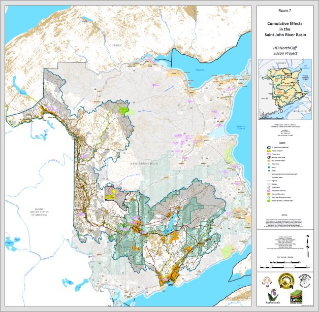
Source: Indigenous Knowledge Study, Moccasin Flower Consulting Inc
5.10.3 Agency analysis and conclusion
The Agency focused its analysis of the effects of Project-related changes to the environment on current use of land and resources for traditional purposes by Aboriginal persons on:
- access to land and resources for traditional hunting, trapping, gathering, fishing and cultural purposes; and
- the cultural context and importance of the project area and local assessment area.
The Agency is of the view that the proponent's methodology for the assessment of effects of the Project on current use by First Nations resulted in an underestimation of potential effects. The proponent used changes to lands and resources as a surrogate for effects on current use rather than examining effects on current use activities independently, limiting consideration of effects on current use outside of its local assessment area and limiting the ability to consider potential cumulative effects on current use. These limitations were identified by the Agency, First Nations, the Province of New Brunswick, and federal authorities throughout the environmental assessment process as adversely affecting the examination of current use.
The Agency acknowledges that the direct loss of access to the local assessment area for current use is unavoidable and irreversible. Loss of use of the majority of the site would be permanent with limited areas suitable for traditional purposes in the future.
The Agency believes that the regional assessment area identified by Maliseet First Nations (the Crown land block) would have been the most appropriate boundary to assess effects on current use. Had this boundary been used, the geographic extent and the significance of the potential residual effects may have been greater than predicted by the proponent in its EIA Report.
In reaching its conclusions, the Agency considers that First Nations may have different thresholds to sensory disturbances compared to receptors/indicators considered by the proponent in assessing biophysical valued components. As such, the integrity of the visual landscape and sensory environment play an important role in determining the suitability of land for continued use. Reduced visual quality, adverse residual effects to water quality, and predicted residual noise and dust effects would limit activities currently undertaken in the area. Consequently, the Agency considers there are likely to be direct and indirect effects that extend beyond the project development area and local assessment area into the Crown land block, which would adversely impact use of the area by First Nations.
The Agency acknowledges that Maliseet First Nations consider the project area to be of high cultural importance and a preferred area for the practice of Aboriginal rights and interests. St. Mary's, Woodstock, Kingsclear and Tobique First Nations have demonstrated that the project area is used by, and of value to, its members because of the quality and quantity of its resources, its proximity to the communities and historical and intergenerational connections. Maliseet First Nations have provided this information through written submissions, the Indigenous Knowledge Study, and in meetings with the proponent and Agency officials. The archeological finds on the project site support the claims of First Nations that this site has long formed part of their territory and cultural landscape (section 5.11). The cultural context is further highlighted by the confirmation by the Province of New Brunswick and Maliseet and Mi'gmag First Nations of a portage route between the Miramichi River system and the Nashwaak River system located close to the project area, as well as in St. Mary's First Nation's comments that lands within the local assessment area are a teaching area used to pass knowledge about traditional land use from one generation to another.
The Agency is of the view that because the current use of the area by First Nations cannot solely be defined by resource availability but also needs to account for cultural values and traditional knowledge, the mitigation measures proposed by the proponent for biophysical valued components do not fully mitigate effects on the current use of lands and resources. Given the specific factors that make this area a preferred site for the Maliseet, the assertion by the proponent that the current uses that have been identified may be transferred to other areas is not substantiated. Current use activities by First Nations (including access, hunting, fishing, and gathering, preference of use, cultural importance, and relative proximity) in their regional assessment area that would have assisted in this analysis was not made available by the proponent.
With respect to Tobique, Kingsclear, Woodstock, and St. Mary's First Nations, the Agency considers the residual adverse effects on current use of lands and resources for traditional purposes to be of high magnitude given the size of the area that would become unavailable and the cultural importance of this area. The Agency considers the effects to be at a regional scale, as defined in the Indigenous Knowledge Study, permanent, continuous, and irreversible. The Agency considers that the measures proposed by the proponent would mitigate some effects on biophysical resources important for current use activities, but fail to address the permanent loss of access to an area of high value, and the associated use of that area.
Based on the above, the Agency concludes that the Sisson Project is likely to result in significant adverse environmental effects on the current use of lands and resources for traditional purposes by Maliseet First Nations.
With respect to Mi'gmag First Nations, the Agency has considered information provided in the proponent's EIA report, the New Brunswick Panel Report, and directly by the Assembly at meetings and through written correspondence. Based on this information, the Agency is of the view that the area most impacted by the Project (the project area) is likely used for traditional purposes by Mi'gmag community members. However, the Agency has determined that the location of the Project is considered to be at boundary of Mi'gmaq traditional territory and therefore use of the project area is likely to be of less intensity and regularity. Additionally, the Project's impacts, in particular potential impacts on surface water and groundwater quality are unlikely to occur in the Miramichi watershed. The Miramachi watershed is the watershed adjacent to the Nashwaak watershed where the Project is located; and an area that is considered to be Mi'gmag traditional territory. Mine contact water and discharges would not flow into the Miramachi watershed. The Agency considers that measures proposed by the proponent to mitigate biophysical effects of the Project , as well as the measures proposed by the Province of New Brunswick as part of its conditions of EIA approval, would mitigate effects on the current use of lands and resources by Mi'gmaq First Nations. The Agency therefore considers the residual adverse effects on current use of lands and resources of Mi'gmag First Nations to be of low magnitude. The proponent has committed to including Mi'gmaq First Nations in follow-up and ongoing environmental management related to the Project; this would ensure that impacts on traditional use are considered throughout the life of the Project.
In assessing cumulative effects on the current use of lands and resources for traditional purposes, residual effects predicted from the Project after taking the implementation of mitigation measures into account must be considered. In understanding the residual current use impacts of the Project and their potential to interact with the effects from other physical activities that have been or will be carried out, the Agency considered information provided by the proponent on the availability of biophysical resources, as well as land use mapping information, both within the proponent's regional assessment area and in the Crown land block, that was identified by Maliseet First Nations in the Indigenous Knowledge Study.
The Indigenous Knowledge Study states that the Maliseet have experienced considerable loss in their livelihood through land and resources being "taken up" by European settlers through forestry, fishing and agriculture. The Crown land block within which the Project would be located is considered to be one of the last remaining large areas accessible for traditional uses with valued resources in Maliseet territory. Based on the available information, the Agency is of the view that areas of New Brunswick are in various states of development and that a limited number of large contiguous Crown land blocks, particularly along the Saint John River valley, remain available to practice current uses for traditional purposes proximal to Tobique, Kingsclear, Woodstock and St. Mary's First Nations. Further, within the remaining Crown land blocks, use by these First Nations is limited by other existing land uses. Given this context, the loss of the cultural value of the project site and its important contribution to current use of lands and resources by Maliseet First Nations would exacerbate the considerable effects on current use that are currently being experienced at a regional scale.
The Agency concludes that the effects of the Project on the current use of lands and resources for traditional purposes by Maliseet First Nations, in combination with the cumulative environmental effects of other projects and activities, are also likely to be significant.
The Agency has been informed that the Province of New Brunswick and Maliseet First Nations are negotiating accommodation for project effects. Additional mitigation may result from these discussions.
5.11 Heritage Resources
This subsection discusses effects on archaeological resources found in the project development area. Other aspects of cultural importance are discussed in the section 5.10. .
In 2011, when the proponent conducted a desktop study and an archaeological field assessment of the project development area, several locations were found to have elevated archaeological potential. Extensive shovel testing was undertaken between 2012 and 2015 resulting in the discovery and delineation of two archaeological sites within the proposed mine area, one within the tailings storage facility and one in the open pit.
The proponent provided 614 potential artifacts to the Province of New Brunswick's Archaeological Services. A subsequent review by provincial staff, independent experts, and experts provided by First Nations, determined that 26 of the 614 articles were archeological artifacts, with the remaining objects being shaped by natural processes or forestry road building.
The archaeological site in the location of the proposed open pit likely represents a middle to late Middle Archaic period (7500 to 6000 years old) occupation site. It extends over an area of approximately 190 square meters, but has very low artifact density suggesting a single dispersed occupation or multiple small short-term occupations in a localized area. The Province of New Brunswick stated that there are between 12 and 15 recorded archaeological sites from the same approximate age in New Brunswick. To date, only a single site from this time period has been the subject to controlled excavation; providing all that is currently known about this 1500 year period of the Province's history.
The archeological site in the location of the proposed tailings storage facility (62.5 square meters) likely represents a short-term camp or activity area (i.e. hunting, processing, butchering or perhaps trapping) potentially dating to the Terminal (or Transitional) Archaic period (4400 to 3200 years old). Additional research obtained through controlled excavation would be required to more precisely and definitively date this site. There are currently over 30 recorded archaeological sites in New Brunswick which date to this time period.
In relation to other heritage resources (i.e. beside archaeological finds), the proponent determined that:
- there are no fossil localities or paleontological resources in vicinity of the Project; and,
- there are no known architectural resources or in or near the project development area.
During the Historic Period, there was little settlement within and near the project area prior to the construction of a sawmill near Juniper on the South Branch Southwest Miramichi River in 1914.
5.11.1 Proponent's Assessment of Potential Environmental Effects and Mitigation
Archaeological resources, where present, are located in the upper soil layers of the earth and therefore potential interactions between these resources and the Project would most likely take place during ground breaking activities. While the open pit and the tailings storage facility would increase in size throughout the life of the Project, most of the potential impacts of the Project on heritage resources would occur during construction. Construction of the tailings storage facility would include the construction of embankments, and then flooding of most low lying areas, which is where the majority of elevated archaeological potential areas are located.
The proponent stated that the location of the two discovered archeological sites in the tailings storage facility and open pit means that avoidance would not be a viable mitigation option. Should the Project proceed, controlled excavation of the sites under the supervision of a permitted professional archaeologist would occur, prior to any construction in these areas. The controlled excavation of these two archaeological sites would also occur in consultation with First Nations and the Province of New Brunswick.
The proponent stated that following excavation, it would catalogue artifacts and complete a preliminary analysis. As a condition of the Archaeological Field Research Permit, the proponent's results would be presented in a technical report, which would be archived and available through the Province of New Brunswick along with all photographs, maps, and field notes from the Project. Artifacts would then be curated by the Province of New Brunswick in trust for First Nations until alternate curatorial arrangements were made.
The proponent prepared a Heritage Mitigation Plan for the Project. The plan includes procedures for the handling of artifacts, protocols for communicating noteworthy discoveries, and training of on-site staff. The plan also outlines procedures for completing excavation and management of the two identified archaeological sites
In relation to other project infrastructure; should heritage resources be encountered elsewhere in the project development area, the proponent stated it would consider avoiding these sites where technically and economically feasible. For example, prior to construction of the transmission line, the proponent stated that it would conduct an archaeological survey to inform placement of transmission line towers to avoid areas of elevated archaeological potential.
The proponent predicted that the residual effects of the Project on physical and cultural heritage resources would be high in magnitude, occur within the project development area, and be permanent and irreversible. Based on the completion of the archaeological assessment (i.e. test pits and delineation of identified archaeological sites), independent review of objects collected in 2013/2014, and implementation of the Heritage Mitigation Plan, the proponent concluded that with the planned mitigation (Appendix E), the residual environmental effects of the Project on heritage resources were unlikely to be significant.
Assessment of Cumulative Effects
The proponent predicted that past, present and reasonably foreseeable projects or activities, namely current use of lands and resources for traditional purposes by First Nations, industrial and residential land use, forestry and agriculture typically have not required, and will not require, substantial ground disturbance and are therefore unlikely to result in overlapping effects with the Project. Furthermore, the proponent anticipated that environmental assessment and mitigation requirements for other projects would be required prior to future development. With a high level of confidence, the proponent predicted that the environmental effects of the Project in combination with those of other projects or activities that have been or will be carried out on heritage resources are unlikely to be significant.
Monitoring and Follow up
Since implementation of the Heritage Mitigation Plan would result in the full recovery of identified archaeological resources and associated information from the project site, the proponent stated that a follow-up program (to determine the effectiveness of mitigation) would not be required.
5.11.2 Views Expressed
Maliseet and Mi'gmag First Nations stated that archaeological resources in the project area are of potential significance and expressed concern that these would be disturbed or damaged by the Project. They stated that avoidance of archaeological resources was preferred to excavation and that areas confirmed as having a high or medium potential to contain archaeological resources should be avoided by design. The proponent stated that, given the location of the two identified sites, avoidance would not be an option should the Project proceed.
The Assembly noted that the mine and surrounding area have been used by the Maliseet and Mi'gmag First Nations for generations and therefore the presence of cultural and/or spiritual sites was expected in the area.
Following archaeological finds in 2012, Maliseet and Mi'gmag First Nations expressed concern over their lack of involvement in conducting baseline work in relation to heritage resources. They also requested capacity building and involvement in the assessment of heritage resources. At that time, the proponent responded by:
- providing archaeological permit reports summarizing the results of the archaeological field work to Maliseet and Mi'gmag First Nations (2011 to 2014);
- inviting Maliseet and Mi'gmag First Nations to field visits to view the 2012 and 2013 archaeological work;
- consulting with Maliseet and Mi'gmag First Nations prior to commencing the 2013 field program;
- providing field technician employment opportunities to Maliseet and Mi'gmag First Nations representatives in advance of field programs (one First Nation field technician was hired in 2011, two in 2012, and three in 2013);
- funding a First Nation-appointed field monitor in 2013 (i.e. to observe the field work and report back to Maliseet and Mi'gmag First Nations' leadership) and an independent archaeologist appointed by Maliseet and Mi'gmag First Nations for 2014 (i.e. to facilitate communication and understanding of the archaeological mitigation); and
- making an ongoing commitment to meet with Maliseet and Mi'gmag First Nations to discuss the archaeological program, consider feedback, and respond, as appropriate.
In 2014, a Sisson Project Archaeological Advisory Group was formed, which included provincial government departments and Maliseet and Mi'gmag First Nations, to provide a forum to: discuss issues; exchange information and views pertaining to archaeological work; and provide advice to the provincial Ministers.
Based on 2012 and 2013 archeological finds and following requests from the Agency, Maliseet and Mi'gmag First Nations, and the Province of New Brunswick for additional information, a program to complete outstanding archaeological fieldwork within the footprint of the tailings storage facility and open pit was launched in 2015 by the Province of New Brunswick in partnership with the six Maliseet First Nations (Kingsclear, St Mary's, Madawaska, Oromocto, Tobique, Woodstock). The Province of New Brunswick advised that the 2015 archaeological assessment program was designed to maximize engagement and participation of First Nations. Approximately, 75 individuals from the six Maliseet First Nations communities participated in the archaeological program.
Following the launch of the 2015 program, the Province of New Brunswick deemed that the Sisson Project Archaeology Advisory Group was no longer necessary, given that a process for communication and discussion between the First Nations, the Province of New Brunswick, and the consultant holding the archaeological permit had been established.
In December 2015, the proponent submitted results of the 2015 archaeological assessment program to the Agency, in association with an updated analysis of potential impacts of the Project on heritage resources. At the same time the Province of New Brunswick advised the Agency that:
- the project development area had been thoroughly and extensively tested to requisite professional standards and results should be accepted accordingly and
- the mitigation proposed would address the physical impact of the Project on the identified heritage resources.
As part of conditions of EIA approval, the Province of New Brunswick would require the proponent to develop a Heritage Resource Protection Protocol that would include the existing Heritage Mitigation Plan, as well as a detailed, site-specific plan to mitigate potential impacts on existing archaeological resources prior to construction. The Heritage Resource Protection Protocol would require completion of all outstanding archaeological assessment work (e.g. test pitting of any remaining project areas) and any resulting site specific mitigation prior to initiation of construction in those areas. Should archaeological resources be found during construction, all activity near the find would be stopped and the Province of New Brunswick contacted. Maliseet First Nations noted that much of a site's historical value is lost when a site is decontextualized (e.g. excavated, bagged, and boxed). They advised that excavation of sites is not considered adequate mitigation from a Maliseet perspective. Maliseet First Nations requested capacity funding and opportunities to update the Sisson Project Heritage Mitigation Plan prior to any mitigation taking place. They also asked to have representatives on site during construction to monitor for chance archaeological finds.
5.11.3 Agency Analysis and Conclusions
Based on expert advice provided by the Province of New Brunswick, the Agency is satisfied that sufficient baseline information exists to draw conclusions about the potential significance of effects on heritage resources.
In coming to its conclusion, the Agency recognises the importance of archaeological resources to First Nations. For elements of the Project that the proponent considers immovable (i.e. tailings storage facility and open pit), the Project would result in controlled excavation of two archaeological sites, in a manner that would be consistent with provincial requirements, supervised by a permitted professional archaeologist, and undertaken in direct consultation with First Nations. The proponent would record and manage resulting resources to preserve their historical value and integrity. In accordance with the Province of New Brunswick's legislation, these artifacts would be held in trust for First Nations. The Province of New Brunswick advised the Agency that the mitigation proposed would address the physical effect of the Project on the identified heritage resources.
For other project infrastructure, avoidance of archaeological sites encountered during construction within the project development area would be considered where technically and economically feasible.
Based on the above, the Agency considers the residual effects on archeological resources would be: moderate in magnitude, have a geographic extent that is localised (within the two delineated sites), occur during construction, and be irreversible and permanent in nature. Taking into account the implementation of applicable mitigation, the Agency is of the view that the Project is not likely to result in significant adverse environmental effects on heritage.
6 Other Effects Considered
6.1 Effects of Accidents and Malfunctions
6.1.1 Proponent's Assessment of Potential Environmental Effects and Mitigation
Accidents and malfunctions assessed by the proponent included: erosion and sediment control failure; pipeline leaks; on-site hazardous materials spills; release of off-specification effluent from the water treatment plant; failure of water management pond pumps; and fire. In response to public, Maliseet and Mi'gmag First Nations, and government comments, the proponent also provided information on the potential effects of loss of containment of the tailings storage facility. This scenario along with potential pipeline failure and release of off-specification effluent from the water treatment plant are discussed below.
Tailings Storage Facility Failure
The proponent stated that slope failure could result in the breach of a tailings storage facility embankment, although this is highly unlikely to occur (annual probability of one in one million to one in ten million). Slope failure could result if an event were to occur that is outside the facility's design criteria, such as an earthquake with an unaccounted magnitude or an extreme rainfall event that is greater than planned for. The proponent predicted that in a worst-case scenario (i.e. when the tailings storage facility is at its maximum size towards the end of operations), an embankment breach would release less than one fifth of the contained tailings (247 million cubic meters) and water (23 million cubic meters) to the environment, possibly in a matter of hours. Such an event could result in the following:
- direct mortality of fish, aquatic plants, and wildlife;
- smothering of downstream aquatic habitat with fine tailings solids in Napadogan Brook and potentially further downstream;
- degradation of water quality in Napadogan Brook and potentially further downstream;
- loss of fish productivity where habitat is smothered or water quality becomes not conducive to fish health;
- loss of wetlands, vegetation and other terrestrial habitat due to the flooding, erosion and/or deposition of tailings and other sediment;
- adverse health effects on wildlife as a result of degraded water quality;
- loss of access to land and terrestrial and aquatic resources for traditional use purposes;
- a decline in water quality that may affect downstream users of water resources;
- prohibitions on fishing, hunting, and use of affected surface waters for drinking and recreational activities to protect human health; and
- loss of access to land for Indigenous and non-Indigenous users.
Mitigation measures to prevent a tailings storage facility failure include:
- meeting and/or exceeding requirements of the Canadian Dam Association's Dam Safety Guidelines;
- designing and constructing the tailings storage facility under supervision of qualified geotechnical engineers;
- review and approval of design plans by the Province of New Brunswick;
- having a qualified engineer conduct annual embankment safety inspections and embankment safety reviews every five years; and
- having a qualified geotechnical engineer conduct embankment safety inspections following closure in accordance with the proposed decommissioning, reclamation, and closure plan and Canadian Dam Association Dam Safety Guidelines.
In the case of a tailings storage facility failure, the proponent's Emergency Preparedness and Response Plan would include measures such as: ceasing of tailings deposition; conducting a safety and preliminary damage assessment; initiating immediate containment activities using on-site heavy equipment and restoring safe working conditions in the area; contacting government personnel and community representatives; and containment of potential threats to the public, the environment, and damaged areas, as appropriate.
The proponent predicted that the environmental effects of a major failure of the tailings storage facility would be substantive and significant, especially in the aquatic environment; however, such a failure would be extremely unlikely to occur.
Pipeline Leak
A leak or rupture of the tailings pipeline or the reclaim pipeline could result in a spill of tailings or reclaim water onto the project development area and could result in adverse effects on surface and groundwater. The proponent stated that a worst case scenario would be the leak of the entire contents of the tailings pipeline (about 800 cubic meters of tailings slurry). A leak from the reclaim pipeline could result in the loss of reclaim water at a rate of ten litres per hour, until the leak is detected and repaired. Mitigation to address the effects of a pipeline leak would include locating pipelines in developed areas of the project development area, and within collection channels to ensure that the released tailings or reclaim water would not leave the project development area. Ditches, collection channels, berms and emergency tailings containment ponds would also be installed to capture and contain tailings in the event of a leak. The proponent committed to regularly inspect pipelines and monitor pipeline pressure.
Given the nature of the potential interactions, and planned design and mitigation measures, the proponent predicted that the environmental effects of a pipeline leak would not be significant.
Release of Off-Specification Effluent from the Water Treatment Plant
For the purpose of the assessment, mechanical or instrument failure in the water treatment plant was assumed to result in the release of up to 685 cubic meters per hour of off-specification effluent (i.e. exceeding the Metal Mining Effluent Regulations or provincial effluent discharge standards) over a twelve hour period. Discharge of this effluent into the residual segment of Sisson Brook could contaminate downstream surface water (i.e. West Branch Napadogan Brook) and associated fish and fish habitat, and result in short-term ingestion/uptake of contaminants by fish, wildlife, and cabin owners. The proponent stated that equipment and monitoring of effluent from the water treatment plant would allow for the release of off-specification effluent to be detected within twelve hours. If contaminants above permitted levels were to be indicated, the plant would be temporarily shut down until repairs to the facility and/or treatment process could be implemented to meet the permitted levels for effluent release. If off-specification effluent were detected, warning and public advisories would be posted and broadcasted to potential resource users and appropriate government regulators (e.g. Environment and Climate Change Canada, Province of New Brunswick) would be notified. An alternate drinking water source (such as bottled water) would be provided to downstream water users until parameters returned to acceptable levels.
In consideration of the planned mitigation and response procedures, the proponent predicted that the residual environmental effect of a release of off-specification effluent from the water treatment plant was not likely to be significant.
6.1.2 Views Expressed
The public, Maliseet and Mi'gmag First Nations, the Province of New Brunswick, and the federal government asked about the potential for a tailing storage facility embankment failure. The Agency asked the proponent to consider recommendations of the Report on Mount Polley Tailings Storage Facility Breach (January 2015) and whether additional or strengthened mitigation was necessary as a result of the report. The proponent responded that it reviewed the reported causes of the Mount Polley tailing storage facility failure, and concluded that its current design and operational plans would ensure that these causes would be avoided for the Project. It stated that the tailings storage facility had been designed and would be constructed and operated with consideration of current design standards and to meet conservative factors of safety appropriate to a modern tailing storage facility in New Brunswick under regulation by the Province of New Brunswick. Under these conditions, a major failure of the tailings storage facility embankment would have an extremely low likelihood of occurrence.
St. Mary's First Nation commissioned a study to assess the potential impacts of a tailings storage facility containment failure on aquatic habitat in the Nashwaak River, with a focus on species of cultural importance to the Maliseet (i.e. Atlantic Salmon and American Eel). The study concluded that a tailings dam failure would likely eliminate Atlantic Salmon from the West Branch of Napadogan Brook and have a significant effect on salmon in Napadogan Brook and the Nashwaak River. The report provided recommendations for further study to better predict the short and long-term impacts of an accidental release from the tailings storage facility on the Nashwaak River. It indicated that such an assessment should be completed with the aim of creating a "before" dataset for the Nashwaak River watershed that could be used to guide remediation goals should an accidental tailings release occur. The report also recommended that the proponent present a detailed response plan for an accidental release of tailings, including plans for containment and remediation, and consultation with First Nations to identify important ecological and cultural areas in the Nashwaak River watershed.
The Agency asked the proponent to consider the St. Mary's First Nation-commissioned report in its analysis of potential accidents and malfunctions. The proponent concluded that the findings of the report did not change the conclusions of its analysis: that the environmental effects of a major tailings storage facility embankment failure would be significant, but that they were very unlikely to occur. The proponent reiterated its commitment to preparing a detailed Emergency Preparedness and Response Plan prior to the start of operations, and to consulting stakeholders, including First Nations, on the development of this plan. In addition, it stated that the relevance and usefulness of the additional studies recommended by the St. Mary's First Nation-commissioned report would be considered during detailed preparation of the Emergency Preparedness and Response Plan.
Through their comments on the draft Report, Maliseet and Mi'gmag First Nations requested that the Emergency Preparedness and Response Plan contain a specific notification and communications protocol for accidents and malfunctions, including measures to notify members of the public who may be adversely affected by accidental events. The Assembly (Mi'gmag First Nations) also requested that the proponent adopt the United Nations Environment Programme Awareness and Preparedness for Emergencies on a Local Level Protocol to guide the design of their Emergency Preparedness and Response Plan. Maliseet First Nations requested that they be provided an opportunity to be involved in the development of adaptive management plans and review the Emergency Preparedness and Response Plans in relation to fish and fish habitat.
Natural Resources Canada reviewed the proponent's analysis of seismicity in the region, including the potential for an earthquake to affect the integrity of project components including the tailings storage facility. Natural Resources Canada confirmed that the proponent's analysis was acceptable and noted its commitment to "design for geotechnical stability for the most significant earthquake loading relating to the largest applicable seismic event (known as the Maximum Design Earthquake)".
The Province of New Brunswick and Maliseet and Mi'gmag First Nations requested additional information on the potential for failure of water management ponds [21], including the stability of the pond liners and possible pump malfunctions. The proponent indicated that the ponds would be lined with high density polyethylene geomembranes with a design storage capacity from 11,000 cubic metres to 18,500 cubic metres. The ponds would be kept relatively dry and at reasonable operating levels by periodic pumping of collected water back into the tailings storage facility. The geosynthetic liner at the bottom of water management ponds would have high structural integrity and effectively prevent the leakage of liquids. The proponent committed to conducting regular inspections of the integrity of the liner system and concluded that an accident scenario involving a structural failure of a waste management pond itself was not a credible scenario.
Natural Resources Canada recommended that if off-specification effluent were to be released from the water treatment plant, the proponent should consider interrupting operations to avoid impacts on groundwater and surface water. The proponent stated that a contingency plan for this scenario would be developed. If regular monitoring were to indicate that the water treatment plant effluent exceeds specifications, then the discharge would be immediately stopped and redirected to the tailings storage facility. The tailings storage facility would have adequate capacity to manage water during temporary shut-down of the water treatment plant. An investigation would be initiated and required actions implemented prior to restoring operation of the water treatment plant. The proponent would develop and implement an adaptive management plan in consultation with appropriate regulatory authorities to restore normal operations, as required. The Assembly (Mi'gmag First Nations) recommended that the proponent narrow the time required to detect a release of off-specification effluent to one hour or less. The Province of New Brunswick indicated that the details of the Emergency Preparedness and Response Program, including detection and contingency systems for the release of off-specification effluent, would be developed at a later date, and that this recommendation would be considered.
As part of its conditions of EIA approval, the Province of New Brunswick would require the proponent to undertake tailing storage facility failure modelling by a qualified third party for the final engineered design and for each approved lift of the tailing storage facility structure. The proponent would also be required to fund an independent tailings review board to evaluate the design, construction and performance of the tailing storage facility consistent with good practice and best available technology. The independent tailings review board would be established prior to construction and would continue to function for the duration of the project life including decommissioning. It would report regularly to the Province of New Brunswick.
In addition, the Province of New Brunswick would require proponent to develop and submit for review and approval an Emergency Preparedness and Response Program. The program would include events such as overtopping and partial or full breach of the tailing storage facility. The proponent would be required to consult with government agencies, stakeholders, and First Nations to ensure the program is effective in dealing with the physical, ecological, and social risks associated with potential accidents and emergencies. It would also require a tailing storage facility Operation, Maintenance and Surveillance Manual, including a schedule for safety inspections and detailed compliance monitoring and reporting, to be revised every five years in accordance with the Canadian Dam Association's Dam Safety Guidelines and any other regulatory instruments deemed appropriate by regulators.
6.1.3 Agency Conclusion
The Agency is satisfied that the proponent identified and assessed the potential accidents and malfunctions associated with the Project. The proponent proposed measures to avoid or prevent potential accidents and malfunctions, and contingency and response plans would be in place should an accident or malfunction occur. It is noted that the proponent committed to designing for geotechnical stability for the most significant earthquake loading relating to the largest applicable seismic event.
The Agency heard comments from the public and Maliseet and Mi'gmag First Nations about the potential for a tailings storage facility failure. The Agency notes that, as part of the conditions of EIA approval, the Province of New Brunswick would require the proponent to undertake tailing storage facility failure modelling by a qualified third party for the final engineered design and for each approved lift of the tailing storage facility structure. In addition, the proponent would be required to fund an independent tailings review board to evaluate the design, construction and performance of its tailing storage facility consistent with good practice and best available technology.
Taking into account the mitigation measures proposed by the proponent and required by the Province of New Brunswick (Appendix C), the Agency considers the adverse residual effects of accidents and malfunctions would be high in magnitude and regional in geographic extent. Taking into account applicable mitigation, the Agency is of the view that the environmental effects of accidents and malfunction would be significant, but are unlikely to occur.
6.2 Effects of the Environment on the Project
Extreme environmental events such as severe weather (e.g. wind, precipitation, floods, hail, electrical storms, and tornadoes), climate change, seismic activity, and forest fires could affect the construction of the Project, project infrastructure or operational performance, and increase the probability of accidents and malfunctions. Resulting environmental effects could include the loss or contamination of habitat, reduced water and air quality, and effects on fish and wildlife.
6.2.1 Proponent's Assessment of Potential Environmental Effects and Mitigation
Extreme Weather and Climate Change
The frequency and intensity of extreme weather events is predicted to increase as a result of climate change. The proponent reported that extreme weather has the potential to affect the integrity and function of key project infrastructure. These effects on the Project could result in adverse environmental effects due to increased sedimentation and erosion, uncontrolled releases of site contact and process water, and increased air emissions.
The proponent indicated that Project components would be designed to meet the National Building Code of Canada and other design codes and standards for wind, extreme precipitation, and other weather variables. The effects of site run-off and erosion from extreme precipitation and potential flooding would be mitigated with the collection and management of site water, the use of erosion and sedimentation control structures, and construction methods that stabilize erodible soils.
The tailings storage facility would be designed to account for extreme weather events and any increase in the frequency or intensity of weather events over the life of the Project. The tailings storage facility would be constructed to meet the Canadian Dam Association's Dam Safety Guidelines and with sufficient capacity and freeboard to store the probable maximum precipitation during operations and into post-closure. Major structures would be re-assessed prior to construction to ensure that any observed or predicted changes in the environment would be accounted for in design.
Contingency plans, including emergency back-up power for necessary operations, would be in place to manage temporary power outages.
Seismic Activity
The proponent reported that seismic events could destabilize project infrastructure (e.g. building foundations) and the integrity of the tailings storage facility. This could lead to uncontrolled discharges of mine contact water affecting downstream water quality. The proponent advised that project and related infrastructure would be designed to account for a one-in-2,500-year seismic event. The tailings storage facility would be constructed to meet the Dam Safety Guidelines of the Canadian Dam Association for a one-in-5000 year seismic event.
Forest Fire
The proponent reported that, if a forest fire were to affect the Project, it could cause fuel and other flammable material on site to catch fire resulting in explosions. This would release emissions to the atmosphere, affect forest adjacent to the site, endanger wildlife, and affect the ability of the public and First Nations to use forest surrounding the Project. Effects of forest fires would be mitigated through the development and maintenance of a cleared buffer around project infrastructure, where feasible. Fire detection and firefighting capabilities on-site, and coordination with community and provincial emergency response crews, would provide rapid detection and response to fire threats.
6.2.2 Views Expressed
The public and Mi'gmag First Nations asked for additional information on seismic stability modeling and requested that recent seismic activity be considered in the assessment of the effects of the environment on the Project. The proponent responded that more detailed modelling may be undertaken during the basic engineering design phase of the Project, with input from regulatory agencies. As part of its conditions of EIA approval, the Province of New Brunswick would require the proponent to undertake a variety of measures to ensure proper design and operation of the tailings storage facility (section 6.1).The public asked about the potential for extreme weather events to affect water management components of the Project. The proponent indicated that water management ponds and associated systems would have the capacity to handle extreme rainfall events, including a one in ten year event, 24-hour storm event (Type-III), as well as associated snowmelt and seepage.
Maliseet and Mi'gmag First Nations expressed concern about the effects of climate change (i.e. increasing storm frequencies) on the dam embankment, and requested more information about inspections post-closure. The proponent highlighted that major structures would be re-assessed prior to construction to ensure that any observed or predicted changes in the environment would be accounted for in design and operations. The proponent noted that mitigation would include measures for avoiding a tailing storage facility embankment failure, and would include a safety inspection regime, and the relevant emergency response procedures in the unlikely event of an embankment failure. Overall, the proponent considered the risk associated with the potential underestimation of the Probable Maximum Flood due to climate change to be very small. As part of its conditions of EIA approval, the Province of New Brunswick would require an Environmental Protection Plan, which would include a tailings storage facility operation, maintenance and surveillance manual developed and submitted for approval prior to commissioning. The manual would also be required to include a schedule for safety inspections and detailed compliance monitoring and reporting and would be reviewed and revised every 5 years in accordance with the Canadian Dam Safety Guideline and other regulatory instruments determined by regulators to be necessary. As part its conditions of EIA approval, the Province of New Brunswick would also require the proponent to develop adaptive monitoring programs, in consultation with First Nations, which would include climate change considerations and conduct further analysis related to the potential impacts of the environment on the Project following detailed project design.
Maliseet and Mi'gmag First Nations requested clarification on the accuracy of estimated flood predictions used in the design of the tailings storage facility. The proponent explained that the inflow design flood was estimated using the total potential run-off depth (i.e. 583 millimeters). Maliseet and Mi'gmag First Nations noted that additional freeboard height requirements for wind-wave effects on the tailings storage facility were not documented in the proponent's EIA Report. The proponent explained that the design of the tailings storage facility would include two meters of freeboard above the maximum level of the inflow design flood and that wave height was estimated to be less than two meters.
In order to reflect uncertainty, Environment and Climate Change Canada recommended the proponent consider more recent projections of annual and seasonal precipitation and temperature from a range of climate models for a number of different future emission scenarios. The proponent re-ran the water balance and predictive water quality modelling based on input from Environment and Climate Change Canada. It concluded that the revised water quality modelling did not lead to a substantive difference in the predicted water quality results nor in the results of the environmental effects assessment.
In addition to the those measures identified in section 6.1, as part of its conditions of EIA approval, the Province of New Brunswick would require the proponent to provide an updated assessment of the potential effects of the environment on the Project (e.g. flood, earthquake, fire) for review and approval following the detailed design phase.
6.2.3 Agency Conclusions
The Agency is of the view that the proponent adequately considered the effects of the environment on the Project for the purposes of the environmental assessment.
6.3 Effects on the Capacity of Renewable Resources
Under section 16(2)(d) of the former Act, a comprehensive study must consider "the capacity of renewable resources that are likely to be significantly affected by the project to meet the needs of the present and those of the future".
Renewable resources that may be affected by the Project include water resources, wetlands, freshwater fish and fish habitat, vegetation and plant communities, and terrestrial resources. Significant adverse residual effects on these resources could, for example, result in a reduced capacity to support sustainable fishing, harvesting, hunting and other renewable resource based activities. Each of these renewable resources was assessed in previous sections of this Report. In each case, based on the implementation of measures proposed to mitigation and compensate the effects, the Agency concluded that the residual effects on these renewable resources were not likely to be significant.
The Agency therefore concludes that the Project is not likely to adversely impact the capacity of renewable resources when the implementation of mitigation measures is taken into account.
7 Consultation with First Nations
The federal government has a legal duty to consult and, where appropriate, to accommodate, First Nations when its proposed conduct might adversely affect potential or established Aboriginal or Treaty rights. Consultation with First Nations is also an important part of good governance and sound policy development and decision making. In addition to the federal government's broader obligations, the former Act requires that all federal EAs consider the effect of any environmental change caused by the Project on the current use of lands and resources for traditional purposes by Aboriginal peoples. The former Act also requires consideration of the effect of any project-related environmental change on physical and cultural heritage, including "any structure, site, or thing that is of historical or archaeological significance."
First Nations were provided with opportunities to (a) learn about the Project, (b) evaluate the Project, and (c) discuss their concerns with the Crown.
The Project is located within the boundaries of the historic Peace and Friendship treaties [22]. Both Maliseet and Mi'gmag First Nations are signatories to these treaties. Rights pursuant to these treaties and as set out in Supreme Court decisions include the right to hunt and fish throughout their territory in pursuit of a moderate livelihood [23] and the right to harvest timber for personal use [24] .
7.1 Consultation Activities
The Agency identified 15 First Nations whose potential or established Aboriginal or Treaty rights could be adversely impacted by the Project (Table 7.1).
|
Maliseet First Nations |
Mi'gmag First Nations |
|---|---|
|
|
In 2011, Maliseet and Mi'gmag First Nations in New Brunswick, with the exception of Woodstock First Nation and St. Mary's First Nation, identified the Assembly as their representative for the purposes of consultation on the Project. As the environmental assessment progressed, other First Nations (Madawaska, Elsipogtog, Oromocto, Kingsclear and Tobique) decided to represent themselves in consultation independently from the Assembly. The Agency sent key documents (e.g. notifications of comment periods) to all Maliseet and Mi'gmag First Nations represented by the Assembly throughout the federal environmental assessment process.
The Agency continued to consult with the Assembly (Mi'gmag First Nations), as a representative body for the remaining Mi'gmag First Nations, for the remainder of the environmental assessment process, but consulted Maliseet First Nations separately. Following their departure from the Assembly in summer and fall 2015, the Agency held face-to-face meetings, monthly phone calls and provided funding to ensure Maliseet groups were prepared to participate in the remainder of the environmental assessment.
Consultation opportunities provided during the environmental assessment of the Project are identified in Table 7.2. In addition, the Agency regularly communicated with Maliseet and Mi'gmag First Nations throughout the environmental assessment process by means of email, telephone, and face-to-face meetings. The Agency and the Province of New Brunswick also engaged with First Nations through a First Nations Environmental Assessment Working Group [25] that was administered by the proponent with representation from provincial and federal departments and Maliseet and Mi'gmag First Nations.
In August 2011, $174,000 was provided through the Agency's Participant Funding Program to support the First Nations' participation in the environmental assessment. In December 2015, the Agency provided $156,300 of supplemental funding to account for the long duration of the environmental assessment, the high volume of information exchanged following the review of the proponent's EIA report, and the change in consultation representation for Maliseet First Nations. Maliseet and Mi'gmag First Nations also received capacity funding from the Province of New Brunswick and the proponent to support their participation in the environmental assessment and related activities.
|
Stage |
Activity |
Timing |
|---|---|---|
|
Environmental Assessment Planning |
Opportunity to comment on the Project and conduct of the comprehensive study. Meetings or phone calls were held to discuss the environmental assessment process, the consultation plan, key points for consultation, and integrated approach to consultation with First Nations. |
May 2011 to October 2012 |
|
Draft Environmental Impact Assessment Joint Terms of Reference |
First Nations were provided 45 days to review of the Draft Environmental Impact Assessment Joint Terms of Reference. Face-to-face meetings to discuss comments were held. Written responses to First Nation's comments were provided. |
August to October 2012 |
|
Baseline Reports |
Federal comments on the baseline technical reports were provided to First Nations for review. |
February 2013 |
|
Summary of Proponent's EIA Report |
First Nations were provided a 45 days to review a summary of the proponent's EIA Report. Face-to-face meetings as well as meetings of the Environmental Assessment Working Group were held to discuss the comments received. |
August to October 2013 |
|
Proponent's Responses to Information Requests |
First Nations were provided an opportunity to review the proponent's responses to information requests. |
May 2014 to May 2015 |
|
Draft Comprehensive Study Report |
First Nations were provided with 21 days to review the draft Comprehensive Study Report and provide comments to the Agency. First Nations were provided with an opportunity to discuss their comments with the Agency directly. |
February 3, 2016 to February 24, 2016 |
|
Final Comprehensive Study Report |
First Nations will be provided with 30 days to review the final Comprehensive Study Report (concurrent with the public review), provide comments and have an opportunity to discuss their comments with the Agency. |
April 15, 2016 to May 16, 2016 |
Provincial Consultation Activities
Provincial consultation on the Project was jointly coordinated by the New Brunswick Aboriginal Affairs Secretariat and Department of Environment and Local Government. In addition to the consultation undertaken jointly with the federal government, the Province of New Brunswick established and coordinated a Sisson Project Archaeology Advisory Group with membership from Maliseet and Mi'gmag First Nations and provincial government departments including Tourism, Heritage and Culture, Environment and Local Government, Natural Resources, Energy and Mines, Aboriginal Affairs Secretariat. This group was formed to exchange information and views pertaining to archaeological work associated with the Project and provide advice to New Brunswick Ministers. The Province of New Brunswick also engaged with Maliseet and Mi'gmag First Nations in various other forums with regard to the Project.
In April 2015, the Province of New Brunswick conducted a 90 day public comment period on the proponent's updated EIA Report and the General Review Statement prepared by the Province of New Brunswick. As part of the public consultation process and in addition to a general public panel meeting, the Province of New Brunswick facilitated independent panel meetings on the Project in several First Nations communities including, Madawaska, Elsipogtog, Tobique, and St. Mary's, and Woodstock First Nations during May and June 2015. In November 2015, the independent panel submitted a report to the Province of New Brunswick which included 47 recommendations. These recommendations were taken into consideration by the Province of New Brunswick prior to making an environmental assessment decision and issuing conditions of EIA approval in December 2015.
Proponent Engagement Activities
Through the EIA Joint Terms of Reference, the Agency instructed the proponent to collect information and assess effects of the Project on the current use of lands and resources for traditional purposes by Aboriginal peoples. The Agency also directed the proponent to document any asserted or established Aboriginal or Treaty rights as conveyed to it by First Nations for the purposes of the environmental assessment.
The proponent established a First Nations Environmental Assessment Working Group which included representatives from St. Mary's First Nation, Woodstock First Nation, the Assembly, the Federal Government, the Province of New Brunswick, and the proponent. The working group met fourteen times between April 2012 and October 2014.
The proponent advised the Agency that between 2012 and 2014, it extended offers to all First Nation communities and to the Assembly to discuss the possibility of developing Process Agreements. The proponent stated that Woodstock First Nation was the only community to respond positively to this offer and that it initiated discussions with this community on the development of a Cooperation Agreement in 2013.
The proponent also stated that between October 2010 and January 2015 it provided $640,652 to Maliseet and Mi'gmag First Nations to participate in environmental assessment processes. An additional $45,000 was provided in 2015 to assist Maliseet and Mi'gmag First Nations on various discussions and funding for community meetings. The funding was for the following activities:
- funding for the completion of an Indigenous Knowledge Study;
- capacity funding for First Nations to participate in the review of the EIA Report;
- Archaeology Program Funding Agreement to allow the participation of First Nations in the Archeological Program undertaken at the proposed mine site;
- capacity funding for Maliseet and Mi'gmag First Nations consultants to participate in Sisson Project Archeological Advisory Group meetings and meetings relating to the Fisheries Authorization and Offsetting Plan review and the follow up and monitoring program review;
- capacity Funding to Tobique First Nation to further discussion on the following activities:
- Environmental follow-up and monitoring opportunities;
- employment opportunities; and
- development of a Cooperation Agreement
- additional funding to the consultants acting on behalf of Maliseet First Nations to undertake additional meetings in the six Maliseet communities; and
- funding related to educational training opportunities, per diems to attend meetings, First Nations sponsorships and meeting administrative activities.
Maliseet and Mi'gmag First Nations raised concerns about the proponent's engagement approach. The Agency received correspondence concerning their dissatisfaction with the level of engagement undertaken, and with the proponent's responses to their concerns. The Agency shared these concerns with the proponent. The proponent maintained that sufficient engagement activities had been offered to First Nations throughout the environmental assessment.
7.2 Potential Adverse Impacts of the Project on Potential or Established Aboriginal or Treaty Rights
The Agency considered the information provided by First Nations as well as information provided by the proponent and the Province of New Brunswick, including the Independent EIA Panel Report completed as part of the New Brunswick environmental assessment process, in determining whether the Project would cause potentially adverse impacts on potential or established Aboriginal or treaty rights; and in considering accommodation measures.
While both Maliseet and Mi'gmag have potential or established Aboriginal or Treaty rights in the project area, the Project is located within the traditional territory of the Maliseet. Maliseet First Nations have asserted Maliseet title to the project area. St. Mary's, Woodstock, Kingsclear, and Tobique First Nations indicated that they have regular and sustained use and exercise of Aboriginal or Treaty rights in the area. The Project is located within a contiguous block of Crown land in an area that the Maliseet state is important to them. St. Mary's, Woodstock, Kingsclear, Madawaksa, and Tobique First Nations have advised that the project area is used by, and of value to, community members because of the quality and quantity of its resources, its proximity to communities, and historical and intergenerational connections.
The main potential adverse impacts on potential or established Aboriginal or Treaty rights identified by Maliseet First Nations include:
- impacts on hunting and trapping from loss of access to the project area. The footprint of the mine and tailings impoundment area would eliminate or make inaccessible traditional use areas, displacing members of St. Mary's, Woodstock, Madawaska, Tobique, Oromocto and Kingsclear First Nations from their preferred areas to practice their asserted or established rights. Specifically, the right to hunt moose as currently practiced by St. Mary's First Nation may be permanently altered by the Project. Moose is a culturally significant species in Maliseet culture and comprises much of the traditional diet;
- permanent alteration of the landscape or the impact of a catastrophic breach of the tailings storage facility creates high levels of stress and fundamental insecurity for Maliseet members about their ability to continue to rely on their traditional land use activities and maintain their deep connections to their territory;
- loss or damage of cultural or archaeological sites and artifacts;
- loss of the project site as a place to exercise traditional practices may permanently disrupt the multi-generational teaching and knowledge transfer undertaken in the project area and local assessment area. Teaching is context and place specific and cannot be replicated in another area;
- potential community socio-economic effects as a result of impacts on their ability to continue traditional practices;
- the loss of brooks, streams, and wetlands would decrease the availability of clean drinking water used by First Nations that hunt, fish, and gather in the project area;
- the loss of fish habitat would affect the availability of trout and other preferred species in the project area and local assessment area;
- potential effects on salmon health and the population in the Nashwaak River due to effects of seepage from the tailings storage facility during operations and the potential for contamination in the case of an accident or malfunction. Salmon is a traditional and culturally significant resource which is under threat in New Brunswick. First Nations are currently prevented from harvesting salmon on the Nashwaak River due to conservation concern. St. Mary's First Nation stated that Project activities that could potentially affect salmon could cause a further erosion of their right to fish them; and,
- noise, light, dust, and potential contamination of water and resources from the Project would affect the suitability (i.e. viewscape, peacefulness, quiet) of reported communal camps located 1.5 kilometers from the Project, displace hunters in areas that extend from one to five kilometers beyond the project footprint and negatively affect the quality of country foods harvested from the project area and local assessment area. This food is shared with members of St. Mary's First Nation who are unable to undertake traditional practices including elders and youth.
Maliseet First Nations also presented the view that cumulative impacts arising from the Project would further erode rights that have already been seriously compromised by a combination of past land privatizations, settlement, and industrial development, overharvesting of key resources (e.g. timber and salmon), and contamination and degradation of fish habitat from development.
The Assembly (Mi'gmag First Nations) advised that the Project is located at the boundary of Mi'gmag traditional territory, but that the Project is located in close proximity to the headwaters of the Miramichi watershed, an area where they assert title. Mi'gmag First Nations indicated some use of the project area (i.e. for harvesting and as a historic portage route) and that there was a close historic relationship between Maliseet and Mi'gmag First Nations, which included extensive use of each other's territories. The main concerns raised by Mi'gmag First Nations regarding potential adverse impacts on potential or established Aboriginal or Treaty rights related to effects on biophysical resources, in particular water quality, fish habitat loss and effects on terrestrial wildlife. Further, Mi'gmag First Nations relayed concerns with potential impacts on archaeological resources that may have historic and cultural value to them.
A summary of key Maliseet and Mi'gmag First Nation concerns, as well as a summary of the proponent's and the Agency's responses, is provided in Appendix H.
7.3 Proposed Accommodation Measures within the Context of the Environmental Assessment
Within the context of the environmental assessment, the proponent committed to the following measures to address potential impacts on potential and or established Aboriginal or Treaty rights:
- limit the size of the project footprint;
- reduce effects on fish, fish habitat and wetlands through compensation plans;
- continue to work with interested Maliseet and Mi'gmag First Nations throughout the life of the Project to identify and implement measures to monitor and avoid or mitigate Project-related environmental effects on the contemporary exercise of asserted or established Aboriginal or Treaty rights;
- continue to engage Maliseet and Mi'gmag First Nations on archaeology (i.e. Heritage Mitigation Plan), fish habitat and wetland offset/compensation, and water quality; and
- establish a follow-up and monitoring sub-committee reporting to a Community Liaison Committee, with Maliseet and Mi'gmag First Nations representation, funded by the proponent.
Additionally, the proponent committed to the following measures outside the context of the environmental assessment:
- work with interested Maliseet and Mi'gmag First Nations communities and organizations to facilitate training, employment and business opportunities;
- build Maliseet and Mi'gmag First Nations' capacity and knowledge in areas of mitigation of Project-related environmental effects on resources valued by those First Nations (e.g. archaeological programs, monitoring of flora and fauna);
- implement a local hire policy to provide qualified Maliseet and Mi'gmag First Nations individuals with employment opportunities; and
- continue to work with organizations such as the Joint Economic Development Initiative and the Aboriginal Workforce Development Initiative to provide training and education opportunities to Maliseet and Mi'gmag First Nations.
In addition to the measures proposed by the proponent, the Province of New Brunswick included conditions in its EIA approval, which would reduce the impact of the Project on potential or established Aboriginal or Treaty rights including:
- development of an engagement strategy that would include employment, training, funding for ongoing consultation, and participation in the Project and seat(s) on the Community Liaison Committee;
- development of adaptive management plans in consultation with First Nations for various biophysical components. The proponent would be required to provide adequate funding for First Nations to fully and meaningfully participate in development, planning and implementation of these plans. Adaptive management plans would consider aquatic resources (specifically Atlantic Salmon), wildlife access to the tailings storage facility, country and traditional foods, socio-economic benefits and employment for First Nations, climate change, and the effects of the environment on the Project;
- development of site specific water quality objectives utilising Canadian Council of Ministers of Environment guidelines and processes, and of a Water Quality Management and Monitoring Plan;
- air quality monitoring, dustfall monitoring, and the development of a Dust Suppression Plan;
- collection of additional quantitative baseline data for animal species of importance to First Nations;
- development of a Wildlife Monitoring Program in consultation with First Nations;
- collection of additional baseline water quality and quantity data;
- collection and /or relocation of plant species of importance to First Nations from the project site prior to construction;
- requirement of a fish habitat offset according to Fisheries and Oceans Canada's requirements;
- conduct of additional pre-construction baseline surveys of traditional country foods;
- collection of additional baseline data on traditional country foods and medicines, to support monitoring for arsenic, chromium, manganese and thallium in order to confirm predictions and assumptions included in the Human Health and Ecological Risk Assessment of the proponent's EIA Report;
- provision of a site-specific mitigation plan for heritage resources within the project footprint, and a framework for appropriate process, including consultation, for any chance discoveries throughout the project life. The proponent will be responsible for all costs associated with this heritage resources mitigation;
- compensation for existing individual or community camp sites within the project development area and local assessment area should the Project impact the use of these camps;
- consultation with First Nations on the development of the closure and reclamation programs and monitoring plans; and
- development of detailed tailing storage facility failure modelling with each successive lift of the tailings storage facility structure.
Maliseet First Nations recommended the following measures to accommodate potential impacts of the Project on asserted or established Aboriginal or Treaty rights:
- development of a rights based and culturally sustaining Land Use Plan for the Maliseet territory in which the Project would be situated;
- revenue sharing with First Nations;
- training, education and employment of First Nation people;
- a community liaison committee be chaired by a neutral party (i.e. as opposed to by the proponent);
- implementation of community-based follow-up and monitoring programs focusing on traditional land and resource users and on First Nations land user experience;
- creation of one or more protected areas of land to ensure that if a significant and preferred piece of Crown land is lost to the Project, the Maliseet at least obtain assured use of one or more other parts of their territory to pursue their traditional activities;
- funding for research on salmon and habitat enhancement; and
- provision or protection of an alternative piece of Crown land to compensate for the loss of the project footprint.
In response to proposals by Maliseet First Nations, the proponent agreed to participate in land use planning if this is initiated by the Province of New Brunswick. As part of the conditions of EIA approval, the Province of New Brunswick would require the proponent to implement targeted employment and training programs for First Nations. Fisheries and Oceans Canada and Environment and Climate Change Canada would require the proponent to involve First Nations in the selection of habitat compensation or enhancement sites should the Project proceed.
Through comments provided on the draft Report, and in addition to comments on biophysical components, the Assembly (Mi'gmag First Nations) requested that:
- any approvals provided to the proponent be conditional on the completion of an indigenous knowledge study for the Mi'gmag to be properly funded by the proponent and
- the Assembly and the Mi'gmag communities be immediately included in all consultation efforts, and particularly discussion and activities specific to the archeological aspects of the Project.
The Assembly (Mi'gmag groups) indicated that without these commitments they do not believe that potential impacts of the project on their asserted or established Aboriginal or Treaty rights have been addressed.
A summary of key First Nation concerns, as well as a summary of the proponent's and the Agency's responses, is provided in Appendix H.
7.4 Issues to Be Addressed During the Regulatory/Approval Phase
If the Project moves to the regulatory approval phase, federal authorizations, approvals or permits related to areas of federal jurisdiction would be required (i.e. effects on fish and fish habitat, the use of a natural water body for mine waste, storage of explosives) from Fisheries and Oceans Canada, Environment and Climate Change Canada, and Natural Resources Canada. The federal Crown would consult Maliseet and Mi'gmag First Nations as appropriate prior to taking regulatory decisions taking into consideration:
- the consultation record resulting from the environmental assessment and
- any potential outstanding concerns not addressed through the environmental assessment.
Upon completion of the environmental assessment, the role of the federal Crown Consultation Coordinator would be transferred from the Agency to Fisheries and Oceans Canada.
The Province of New Brunswick may issue permits associated with the Project and will continue to consult with First Nations on permits, where applicable.
7.5 Agency Conclusion Regarding Impacts on Aboriginal Rights
The Agency has considered the following elements in reaching a conclusion on whether the Project is likely to cause adverse impacts on potential or established Aboriginal or Treaty rights:
- reports (including an Indigenous Knowledge Study), comments (oral and written) and other submissions from Maliseet and Mi'gmag First Nations;
- documentation submitted by the proponent including the EIA Report and responses to information requests;
- effects on valued components that may impact potential or established Aboriginal or Treaty rights and the related mitigation measures, particularly effects on the current use of lands and resources valued component (section 5.10);
- the report of the New Brunswick Independent EIA Review Panel of November 2015;
- the conclusion by the Province of New Brunswick in their General Review Statement (April 2015) that despite proposed mitigation, there would be residual effects on First Nations as a result of the Project and related recommendation that government consider appropriate accommodation to offset these effects. The Province of New Brunswick believes that accommodation may be warranted and recommended that government determine the appropriate accommodation for infringement on Aboriginal and Treaty rights in consultation with First Nations; and
- the terms and conditions of EIA approval issued by the Province of New Brunswick on December 3, 2015.
Regarding potential impacts on the rights of the Mi'gmag, the Project is at the boundary of Mi'gmaq traditional territory and Project impacts are unlikely to occur in the Miramichi watershed, the neighbouring catchment to the one where the Project is located and an area that is considered to be Mi'gmag traditional territory. The Agency considers that the proponent's proposed mitigation, the mitigation measures identified by the Province of New Brunswick in their conditions of EIA approval, and the proponents' commitment to involve the Mi'gmag in monitoring, environmental management planning, and heritage resources mitigation, would be sufficient to accommodate impacts of the Project on potential or established Aboriginal or Treaty rights of the Mi'gmag.
The Agency is of the view that project effects would have the greatest impact on the exercise of rights of the Maliseet First Nations communities most proximal to the Crown land block in which the Project would be located. These are:
- St. Mary's First Nation
- Woodstock First Nation
- Kingsclear First Nation
- Oromocto First Nation
- Tobique First Nation
The Agency considers that the Project would result in the long-term (permanent and irreversible for the pit and tailings storage facility) loss of 1,442 hectares of land that is a preferred resource use area and has high cultural value for Maliseet First Nations in particular in exercising their asserted or established Aboriginal or Treaty Rights. Reclamation of the site to a state where traditional practices could be undertaken would not be possible. The pit and parts of the tailings storage facility would become permanent water features and the steep slopes would present a safety concern for access. Some rehabilitation of the land on which the mine buildings, access roads, transmission line, and tailings storage facility embankments would be located would be possible. The Agency is of the view that project effects on water quality, noise, the visual landscape, and wildlife may deter First Nations from exercising their rights both on and adjacent to the project area. St Mary's First Nations stated that the project development area and local assessment area are used to pass knowledge about traditional land use from one generation to another, as well as being valued as a spiritual area, known to First Nations as being productive and peaceful. Archaeological finds in the open pit and tailings area also provide evidence of the long history of First Nations in the project area and strengthen the cultural importance of the site for First Nations.
The Agency is of the view that proposed mitigation measures such as limiting the project footprint, wetland compensation, and fisheries habitat compensation would reduce impacts of the Project on potential or established Aboriginal or Treaty rights of Maliseet First Nations. However, there are several considerations which limit the ability to which these biophysical measures can serve to accommodate the full extent of potential adverse impacts on potential or established Aboriginal or Treaty rights of the Maliseet First Nations. These include:
- the location of the Project in a preferred and culturally valued area to exercise rights;
- the direct loss of the project site; and
- the relatively limited area available to Maliseet First Nations to practice rights in part due to the cumulative effects of other projects and developments in the province.
The Agency is of the view that the Project would result in potential adverse impacts on the potential or established Aboriginal or Treaty rights of Maliseet First Nations The Agency understands however, that the Province of New Brunswick and Maliseet First Nations are in discussions over further measures that could accommodate potential impacts on potential or established Aboriginal or Treaty rights.
8 PUBLIC CONSULTATION
The former Act requires that the public be provided with a minimum of three formal participation opportunities during a comprehensive study. For this Project, the public consultation periods that were provided by the Agency are listed in Table 8.1.
|
Document/Subject of Consultation |
Dates |
|---|---|
|
* Joint federal-provincial consultation period |
|
|
The Project, the conduct of the comprehensive study, and Draft Terms of Reference for an Environmental Impact Assessment for the Sisson Project* |
18 August 2011 to 3 October 2011 |
|
The proponent's EIA Report and EIA Report Summary |
30 August 2013 to 14 October 2013 |
|
Comprehensive Study Report |
April 15 2016 to May 16 2016 |
The Agency will invite the public and First Nations to comment on this Report. The Minister of the Environment and Climate Change will consider this Report and comments received from the public and First Nations in making her environmental assessment decision.
The Agency supports public participation through its Participant Funding Program. In 2011, a total of $65,000 was allocated to the Nashwaak Watershed Association Inc. and the Conservation Council of New Brunswick Action Inc. to facilitate their participation in the environmental assessment [26] of this Project. In December 2015, the Agency provided $2,200 of supplemental funding to the Nashwaak Watershed Association to support its continued involvement in the environmental assessment.
Public comments received during the review of the proponent's EIA Report Summary were shared with federal expert authorities and the Province of New Brunswick. The Agency considered comments received from the public in preparing this Report. A selection of comments provided by the public is summarised in Table 8.2. Further information on these comments, as well as those provided by First Nations, is included in section 5. Section 10 describes changes to the Project that were made partially in response to public and First Nation comments.
|
Comment Type |
Summary of Issues Raised |
|---|---|
|
Environmental Assessment Methods and Process |
|
|
Decommissioning and Reclamation |
|
|
Alternative Means of Carrying out the Project |
|
|
Atmospheric Environment |
|
|
Water Resources |
|
|
Fish and Fish Habitat |
|
|
Terrestrial Wildlife and Habitat |
|
|
Wetlands |
|
|
Human Health |
|
|
Cumulative Effects |
|
|
Accidents and Malfunctions |
|
Participation Activities by the Proponent
The proponent has been engaging public stakeholders since November 2010, using a range of communications tools. Specifically, the proponent:
- created a project website, which contains information on the Project and company policies (i.e. news releases, frequently-asked-questions, contact information, documents);
- distributed newsletters and email notifications to stakeholders who added their name to a distribution list;
- established an information office in Stanley, New Brunswick, where documents were available for review and representatives available to provide information on the Project, answer questions, and collect comments;
- held open houses in Juniper, Millville, Nackawic, Woodstock, and Stanley, New Brunswick to provide information on the Project and solicit comments, questions, and concerns;
- established working groups on specific issues (e.g. fish and fish habitat, archaeological resources); and
- held presentations, meetings, career information sessions, and workshops with various individuals, stakeholder groups, business associations, and municipal officials.
9 FOLLOW-UP PROGRAM
The former Act requires that the responsible authorities for Sisson Project (i.e. Fisheries and Oceans Canada and Natural Resources Canada) design and ensure the implementation of a follow-up program to verify the accuracy of the environmental assessment and to determine the effectiveness of mitigation measures. The results of a follow-up program may also support the implementation of adaptive management measures to address previously unanticipated adverse environmental effects.
The proponent proposed to monitor various environmental components potentially affected by the Project, as summarized in section 5. The Agency also recommended a follow-up program in relation to specific valued components. These are described in Appendix D.
Government agencies would be involved in the development of elements of the follow-up program relevant to their mandate and expertise. The results of the follow-up program would be reported to relevant agencies. The results of the federal follow-up program, or an indication of how the results may be obtained, would be available to the public through the Agency's Canadian Environmental Assessment Registry (www.ceaa-acee.gc.ca).
In addition to federal follow-up recommendations, the Province of New Brunswick would require the proponent to develop an Environmental and Socioeconomic Management System, which would include adaptive monitoring programs that compare data measurements to predicted values, as well as track changes in data over time. The proponent would be required to develop these programs in consultation with First Nations, stakeholders and appropriate regulatory agencies. Adequate capacity funding must be provided to First Nations to fully and meaningfully participate in the development, planning, and implementation of these monitoring programs.
10 BENEFITS TO CANADIANS
The public and First Nations participating in the environmental assessment provided information and comments that potentially influenced Project design that reduced the environmental effects of the Project. The proponent stated that it incorporated precautionary approaches, conservatism and best management practices (e.g. avoidance) to minimize the ecological footprint of the Project. For example, the proponent redesigned the tailing storage facility footprint to avoid certain fish-bearing watercourses and areas of elevated archaeological potential (Figure 10.1). Similarly, the proponent proposed a waste rock management strategy to store waste rock in the tailings storage facility rather than creating a separate stockpile which would require additional footprint and create unnecessary environmental risks from metal leaching and acid rock drainage.
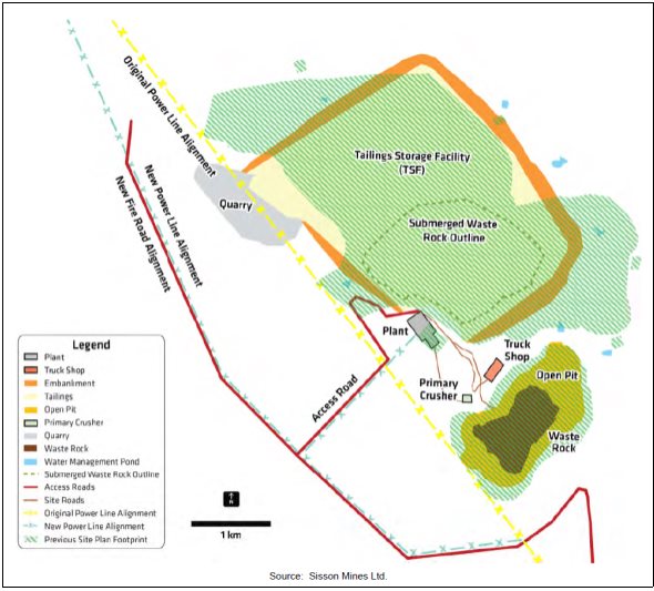
Source: Sisson Project Final Environmental Impact Assessment Report, Stantec Consulting Ltd.
The proponent modified the Project in response to information and comments received from the public, First Nations, or government experts. Key modifications included:
- compensating for the loss of function for affected wetlands following the principles of the federal and provincial wetland policies;
- considering comments from the public and First Nations to help identify suitable projects to offset impacts on fish habitat
- providing an opportunity for First Nations to harvest plants of value to them prior to clearing;
- monitoring of potential effects at two to three traditional use sites identified by First Nations for harvesting of country foods (e.g. fiddleheads, berries, medicinal plants) prior to construction, and within five years of the start of operations; and
- developing and implementing an avian species at risk monitoring and follow-up plan.
In 2015, the Province of New Brunswick in partnership with the six Maliseet First Nations (Kingsclear, St Mary's, Madawaska, Oromocto, Tobique, Woodstock) launched and completed a program to complete outstanding archaeological fieldwork within the footprint of the tailings storage facility and open pit. This program included participation of 75 individuals from these First Nations communities.
11 CONCLUSIONS OF THE AGENCY
The Agency has taken into account the following information in reaching a conclusion on whether the Project is likely to cause significant adverse environmental effects:
- documents submitted by the proponent including the EIA Report and baseline studies;
- questions and comments from First Nations, the public, and government agencies;
- responses to information requests provided by the proponent;
- mitigation measures documented in this Report and summarized in Appendix C;
- the Province of New Brunswick's conditions of EIA approval for the Project;
- analysis and findings of this Report; and
- the federal regulatory authorizations and permits that the proponent would be required to obtain; namely:
- an authorization under paragraph 35(2) of the Fisheries Act, with terms and conditions including an offsetting plan required to offset serious harm to fish;
- a license under the Explosives Act for a temporary magazine;
- requirements under the Metal Mining Effluent Regulations, Schedule 2 amendment process; and
- any future requirements under the Species at Risk Act.
The Project is predicted to result in the loss of land (approximately 1,253 hectares) and residual impacts on resources used by First Nations for traditional purposes. Measures have been identified that would mitigate some of these impacts (e.g. by limiting the size of the Project footprint and by applying mitigation to address impacts on biophysical resources used by First Nations). However, with respect to Maliseet First Nations, the Agency considers that the measures proposed fail to address the permanent loss of access to an area of high value, and the associated use of that area. The Agency concludes that the Sisson Project is likely to result in significant adverse environmental effects on the current use of lands and resources for traditional purposes by Maliseet First Nations. Furthermore, the Agency is of the view that a limited number of large contiguous Crown land blocks, particularly along the Saint John River valley, remain available to practice current uses for traditional purposes proximal to Tobique, Kingsclear, Woodstock and St. Mary's First Nations. Further, within the remaining Crown land blocks, use by these First Nations is limited by other existing land uses. Given this context, the Agency concludes that the environmental effects of the Project, in combination with the cumulative environmental effects of other projects and activities, on the current use of lands and resources by Maliseet First Nations are also likely to be significant.
The Agency has been informed that the Province of New Brunswick and Maliseet First Nations are negotiating accommodation for project effects. Additional mitigation may result from these discussions.
With respect to the other components of the environment, the Agency concludes that the Project is not likely to cause significant adverse environmental effects taking into account the implementation of mitigation measures described in this Report.
A follow-up program would be required to verify the accuracy of the environmental assessment and to determine the effectiveness of the proposed mitigation measures. If the Project proceeds, the Agency recommends that the follow-up program monitor effects on the atmospheric environment, fish and fish habitat, water resources, wildlife, species at risk, wetlands, rare plants, heritage resources, and country foods (Appendix D).
Following public consultation on this Report, the Minister of the Environment and Climate Change will, after considering the Report and comments received in relation to the Report, decide whether, taking into account the implementation of mitigation measures, the Project is likely to cause significant adverse environmental effects. The Project will then be referred back to the responsible authorities, Fisheries and Oceans Canada and Natural Resources Canada, for an appropriate course of action in accordance with Section 37 of the former Act.
12 REFERENCES
Alberta Health and Wellness. 2011. Guidance on Human Health Risk Assessment for Environmental Impact Assessment in Alberta. Available online: http://www.health.alberta.ca/documents/Health-Risk-Enviro-Impact-Guide-2011.pdf
Canadian Council of Ministers of the Environment. 2003. Guidance on the Site-Specific Application of Water Quality Guidelines in Canada: Procedures for Deriving Numerical Water Quality Objectives. Available online: http://ceqg-rcqe.ccme.ca/download/en/221
Canadian Council of Ministers of the Environment. 1999 (updated 2007). Canadian Water Quality Guidelines for the Protection of Aquatic Life (Freshwater). In: Canadian Environmental Quality Guidelines. Available online: http://cegg-rcge.ccme.ca/
Canadian Council of Ministers of the Environment. 1999 (updated 2011). Canadian Soil Quality Guidelines for the Protection of Aquatic Life. In: Canadian Environmental Quality Guidelines. Available online: http://cegg-rcge.ccme.ca/
Canadian Dam Association. 2007 (updated 2013). Dam Safety Guidelines. Available for purchase online: http://www.imis100ca1.ca/cda/Main/Publications/Dam_Safety/CDA/Publications_Pages/Dam_Safety.aspx?hkey=52124537-9256-4c4b-93b2-bd971ed7f425
Canadian Environmental Assessment Agency. 2012. Final Terms of Reference for an Environmental Impact Assessment the Sisson Project, Northcliff Resources Ltd. Available online: http://ceaa.gc.ca/050/documents/55233/55233E.pdf
Canadian Food Inspection Agency. 2015. Canadian Guidelines for Chemical Contaminants and Toxins in Fish and Fish Products. Available online: http://www.inspection.gc.ca/food/fish-and-seafood/manuals/standards-and-methods/eng/1348608971859/1348609209602?chap=7#s20c7
Environment and Climate Change Canada. 2013. Guidelines for the Assessment of Alternatives for Mine Waste Disposal. Available online: http://ec.gc.ca/pollution/default.asp?lang=En&n=125349F7-1
Health Canada. 2010a. Federal Contaminated Site Risk Assessment in Canada: Supplemental Guidance on Human Health Risk Assessment for Country Foods. Available online: http://www.hc-sc.gc.ca/ewh-semt/pubs/contamsite/country_foods-aliments_locale/index-eng.php
Health Canada. 2010b. Useful Information for Environmental Assessments. Available online: http://publications.gc.ca/site/archivee-archived.html?url=http://publications.gc.ca/collections/collection_2015/sc-hc/H128-1-10-599-eng.pdf
Health Canada. 2012. Guidelines for Canadian Drinking Water Quality – Summary Table. Available online: http://www.hc-sc.gc.ca/ewh-semt/pubs/water-eau/sum_guide-res_recom/index-eng.php
United States Environmental Protection Agency. 1989 (updated 2010). Risk Assessment Guidance for Superfund, Volume 1, Human Health Evaluation Manual. Available online: http://www.epa.gov/sites/production/files/2015-09/documents/rags_a.pdf
United States Environmental Protection Agency. (no date). Ecological Soil Screening Level. Available online: http://www.epa.gov/risk/ecological-soil-screening-level-eco-ssl-guidance-and-documents
Appendix A Species at Risk Potentially Found Within or Near the Local Assessment Area
|
Species |
Federal Species at Risk Act (Schedule 1) |
Committee on the Status of Endangered Wildlife in Canada |
New Brunswick Species at Risk Act |
|---|---|---|---|
|
Avian Species |
|||
|
Rusty Blackbird (Euphagus carolinus) |
Special Concern |
Special Concern |
Special Concern |
|
Olive-sided Flycatcher (Contopus cooperi) |
Threatened |
Threatened |
Threatened |
|
Canada Warbler (Wilsonia canadensis) |
Threatened |
Threatened |
Threatened |
|
Bald Eagle (Haliaeetus leucocephalus) |
No Status |
Not at Risk |
Endangered |
|
Common Nighthawk (Chordeiles minor) |
Threatened |
Threatened |
Threatened |
|
Chimney Swift (Chaetura pelagica) |
Threatened |
Threatened |
Threatened |
|
Eastern Wood-pewee (Contopus virens) |
No Status |
Special Concern |
Special Concern |
|
Barn Swallow (Hirundo rustica) |
No Status |
Threatened |
Threatened |
|
Bank Swallow (Riparia riparia) |
No Status |
Threatened |
No Status |
|
Bobolink (Dolichonyx oryzivorus) |
No Status |
Threatened |
Threatened |
|
Mammals |
|||
|
Canada Lynx (Lynx canadensis) |
No Status |
Not at Risk |
Endangered |
|
Tri-colored Bat (Perimyotis subflavus) |
Endangered |
Endangered |
Endangered |
|
Northern Myotis (Myotis septentrionalis) |
Endangered |
Endangered |
Endangered |
|
Little Brown Myotis (Myotis lucifugus) |
Endangered |
Endangered |
Endangered |
|
Herpetiles |
|||
|
Wood Turtle (Glyptemys insculpta) |
Threatened |
Threatened |
Threatened |
|
Plants/Lichens |
|||
|
Eastern Waterfan (Peltigera hydrothyria) |
No Status |
Threatened |
No Status |
|
Black Foam Lichen (Anzia colpodes) |
No Status |
Threatened |
No Status |
|
Anticosti Aster (Symphyotrichum anticostense) |
Threatened |
Threatened |
Endangered |
|
Prototype Quillwort (Isoetes prototypus) |
Special Concern |
Special Concern |
Endangered |
|
Arthropods |
|||
|
Pygmy Snaketail (Ophiogomphus howei) |
Special Concern |
Special Concern |
Special Concern |
|
Molluscs |
|||
|
Brook Floater (Alasmidonta varicose) |
Special Concern |
Special Concern |
Special Concern |
|
Yellow Lampmussel (Lampsilis cariosa) |
Special Concern |
Special Concern |
Special Concern |
Appendix B Proponent's Assessment of Alternative Means of Carrying out the Project
|
Project Component / Alternative Mean |
Description |
Key Considerations Including Potential Adverse Effects |
Preferred Alternative |
|---|---|---|---|
|
Alternative Tailings Storage Facility Locations |
|||
|
Bird Brook Site 1b |
|
|
√ |
|
Bird Brook Site 1c |
|
||
|
Barker Lake |
|
|
|
|
Trouser Lake |
|
|
|
|
Chainy Lakes |
|
|
|
|
Alternative Tailings Management Technologies |
|||
|
Thickened (paste) tailings disposal |
|
|
|
|
Conventional slurry tailings |
|
|
√ |
|
Filtered dry stack tailings |
|
|
|
|
Alternatives for the Management of Ammonium Paratungstate Residues |
|||
|
Storage in the tailings storage facility |
|
|
√ |
|
Storage elsewhere on project site |
|
|
|
|
Off-site disposal |
|
|
|
|
Alternative Tailings Storage Facility Embankment Designs |
|||
|
Upstream construction method |
|
|
|
|
Centreline construction method |
|
|
√ |
|
Downstream construction method |
|
|
|
|
Alternative Electrical Transmission Line Routes |
|||
|
Route A (Keswick Terminal along east side of Line 3011) |
|
|
√ |
|
Route B (from existing Line 1126 near Cloverdale to project site) |
|
|
|
|
Route C (from existing Line 48 in Deersdale to project site) |
|
|
|
|
Alternatives for Fish Habitat Compensation |
|||
|
Removal of the Campbell Creek Dam |
|
|
|
|
Removal of the Lower Lake Dam |
|
|
|
|
Provision of Atlantic salmon passage at the Dunbar Stream Falls |
|
|
|
|
Nashwaak Lake culvert removal/replacement |
|
|
√ |
|
Alternatives for Decommissioning, Reclamation, and Closure of the Open Pit |
|||
|
Open pit not filled with water during closure |
|
|
|
|
Fill open-pit with waste mined material during closure |
|
|
|
|
Fill and maintain open pit with water during closure and post closure |
|
|
√ |
Appendix C Mitigation Measures Identified by the Agency
The following list includes measures that the Canadian Environmental Assessment Agency considers necessary to mitigate the environmental effects of the Sisson Project (the Project). Additional mitigation measures may also be articulated in authorizations that may be issued by the federal or provincial governments.
*Mitigation measures that are based on the Province of New Brunswick's conditions of EIA approval are denoted with an asterisk (*)
+Additional mitigation measures identified by the Agency (i.e. beyond those previously committed to by the proponent or required by the Province of New Brunswick) are denoted with a plus (+)
Atmospheric Environment
- Apply water on the site access road and on-site roads within the project development area (but not on forest resource roads) as required to reduce dust generation (construction and operations).
- Develop dust suppression mitigation and air quality management plans (construction and operations).
- Implement an idling reduction program to minimize engine idling (construction and operations).
- Use mufflers to reduce engine noise (construction and operations).
- Implement equipment and vehicle maintenance program, including preventative maintenance, to improve operational efficiency and reduce emissions (construction and operations).
- As part of the Environmental Management Plan, consider the need for vehicle segregation and washing to prevent contaminants from leaving the mine (construction and operations). +
- Manage overburden to reduce/eliminate risk to air quality, including seeding and re-vegetation of topsoil and overburden storage piles as soon as possible after disturbance (construction and operations).
- Complete drilling and blasting events during daytime hours whenever feasible, minimize the frequency of blasts, and notify nearby residents and camp owners of the blasting schedule (construction and operations).
- Limit construction activity to daytime hours where feasible (construction).
- Use an H2S and NH3 scrubber on the ammonium paratungstate plant (operations).
- Use dust collection systems on primary crusher, ore processing plant and ammonium paratungstate plant (operations).
- Enclose some process equipment in buildings, and partially enclose primary crusher and conveyors (operations).
- Carry out routine trucking during daytime hours only (operations).
- Avoid evening and night-time blasting (i.e. 8 pm to 6 am) (construction and operation).+
Water Resources
- Establish and fund an Independent Tailings Review Board to evaluate the design, construction and performance of the tailings storage facility consistent with good practice and best available technology. The Independent Tailings Review Board should consist of a minimum of two qualified geotechnical engineers, and one other engineer or geoscientist specializing in water chemistry and/or hydrogeology. The Independent Tailings Review Board would be established prior to commencing construction of the mine, and would continue to function for the duration of the project life including decommissioning (pre-construction).*
- Conduct additional site investigations to inform the siting of the water supply wells and confirm the well locations. Following determination of the location of supply wells, evaluate the fresh water supply through a provincial Water Supply Source Assessment. If it is determined that there is not adequate water supply for the Project, look at alternative options (pre-construction).
- Develop further seepage mitigation strategies that may include: grouting of fractured rock, compacting a soil liner in certain areas, and installing a synthetic liner upstream over certain features (pre-construction, operations).
- Develop a detailed waste rock management plan, which includes sampling and analysis of the final pit wall and a waste handling plan for waste rock and low grade ore (pre-construction).
- Evaluate additional mitigation options to deal with uncollected seepage, including engineered wetland systems (pre-construction).
- Test for and map permeable zones of rock disruption/faults, weathered and unconsolidated granitic rock, or other surficial material that is potentially unstable or could act as a water conduit from the tailings containment base to the groundwater outside the tailings storage facility. Use the survey results to plan mitigation for the containment base and dam design as well as locations of monitoring wells. Surveys should be undertaken along the centreline and/or perimeter of the proposed dam base plus at least three east-west and at least three north-south lines across the proposed tailings storage site prior to starting any dam construction (pre-construction).*
- Model the potential groundwater pathways (to surface water receptors) for contaminant migration should the sealed fractures fail. Include a cross-section of flow lines, graphs of hydraulic conductivity vs depth, and inclusion of vertical gradient profiles (pre-construction).
- Conduct geotechnical drilling and test pitting along the centreline of the proposed tailings storage facility dam alignment, in any major surface drainage that pass through the dam alignment, and in areas where the proposed water management ponds are to be located as to allow the proponent to provide a fulsome interpretation of the sub-surface ground conditions. Additional geotechnical drill holes and/or test pits within the tailings storage facility basin must also be completed to investigate the sub-surface ground conditions. The proponent would also collect geological information (i.e. soil and rock types) and geotechnical information (i.e. in-situ permeability of bedrock, in-situ density of soil) and provide a detailed interpretation of the sub-surface ground conditions (pre-construction).*
- Conduct additional hydrogeological testing in order to evaluate the inferred fault zones underlying Sisson Brook and other features that could act as preferential pathways for groundwater movement. Testing must include, but is not limited to, drill holes and packer tests along the alignment of the inferred fault zones underlying Sisson Brook as well as the aligned holes from which water loss was high in the initial packer tests (pre-construction).*
- Undertake a pumping test program to support the potential location and design of interception wells. The results of the pumping test investigation would also be used to further verify the values for transmissivity of the bedrock used in the groundwater modelling work assessing seepage volumes and locations (pre-construction).
- Site fresh water wells outside the zone of influence of the tailings storage facility (pre-construction).
- Construct the tailings storage facility starter dam from non-potentially acid generating local borrow material or rock quarried from the northwest corner of the tailings storage facility (pre-construction).
- Segregate and submerge overburden and soils deemed unsuitable for reclamation in the tailings storage facility (pre-construction).
- Maintain existing drainage patterns to the extent possible (construction).
- Comply with the Wetland and Watercourse Alteration permit (construction).
- Develop and implement a Project Waste Management Plan, which would include details on all project generated wastes, and confirmation that all project related wastes will be disposed of at an appropriate, approved facility (this mitigation measure would apply to other valued components as well) (pre-construction, construction, operations). *
- Develop and implement a Groundwater Protection Plan which includes having all production and monitoring wells shown on site maps and outlines protection measures for wells (e.g. flags, locked caps, no chemical or petroleum storage or fueling near wells). *
- Implement erosion and sedimentation control during construction and during progressive construction of the tailings storage facility and other earth moving activities, and document measures taken as prescribed in the Environmental Protection Plan (construction and operations).
- Implement adaptive management measures to further reduce seepage in the event that follow-up and monitoring identify further mitigation is required (construction and operations).
- Consider measures to reduce erosion in the design of water management structures (i.e. armouring the channel in Sisson Brook) and ensure adequate conveyance in extreme events (construction and operations).
- Consider alternative water release points to alleviate pressure on infrastructure in the water body and its river banks (construction and operations).
- Submerge potentially acid generating waste rock and tailings in the tailings storage facility, preventing oxygen from contacting the material and thus preventing the potential for acid drainage (operations).
- Actively de-water pit with pumps, and ensure water level in the pit is at or near the pit floor (operations).
- Design water management structures to reduce erosion and assure adequate water conveyance in extreme events (operations).
- Construct perimeter ditches around the open pit and waste rock disposal areas to collect and divert runoff and minimize the amount of water in contact with the mine site and facilities (operations).
- Recycle water from the tailings storage facility for use in the ore processing (operations).
- Collect and treat (as required) surplus water from the Project and surplus mine contact water before discharge to the environment (operations).
- Undertake seasonal in-pit water treatment, including lime addition as necessary to ensure acceptable water alkalinity (operations).
- Construct engineered drainage collection channels to collect tailings storage facility embankment run-off and seepage in lined water management ponds and pump back to the tailings storage facility (operations).
- Install and operate groundwater pump-back wells at the northern extent of the tailings storage facility to collect some groundwater seepage that bypasses the collection system for pump back to the water management ponds and tailings storage facility (operations).
- Add a secondary perimeter ditch around the tailings storage facility, maintain low water levels in perimeter and water collection ponds, reduce the length of ditches between water management ponds, and line perimeter ditches for additional seepage control (operations).
- As needed, undertake special measures to mitigate seepage in areas that require further engineered solutions, such as grouting of bedrock (operations).
- Conduct ongoing geochemical characterisation of waste streams and ores so as to enable appropriate management (operations).
- Integrate the contingency plan for a release of off-specification effluent from water treatment plant into the Environmental Management Plan and Emergency Preparedness and Response Plan. If monitoring indicates that the water treatment plant effluent exceeds specifications, immediately stop the discharge and redirect it to the tailings storage facility. Ensure the tailings storage facility has adequate capacity to manage such water during temporary shut-down of the water treatment plant. Take required actions to restore proper water treatment prior to any further release and address any potential causative factors (operations).
- Store ammonium paratungstate plant wastes in self-contained cells in the tailings storage facility. Equip these cells with a leak detection and recovery system (operations).
- Implement an adaptive management plan integrated with follow-up and monitoring to identify the need for and install groundwater monitoring wells (in both superficial sediments and in bedrock) below the tailings storage facility water management ponds to monitor the groundwater quality, which can be converted to groundwater pump-back wells should downstream water quality monitoring indicate that seepage is jeopardizing downstream water quality objectives (operations).
- Construct engineered drainage and diversion channels to divert non-contact water around the project facilities wherever possible (operations).
- Flood the open pit to minimize potential metal leaching and acid rock drainage from remaining pit walls (decommissioning, reclamation, and closure).
- Prior to initiation of water releases from the open pit lake, establish the prevailing water quality conditions in the lake via limnological studies. Reconfigure the water management system to ensure that all water discharged from the open pit lake can be treated, if needed, to meet discharge permit requirements for as long as is required. While such treatment is needed, manage the elevation of the pit lake to ensure that groundwater flows into, and not out of, it by pumping the lake water to the water treatment plant before discharge (decommissioning, reclamation and closure).
- Place the mid-grade ore stockpile in the tailings storage facility in successive lifts. Sample dump crests to confirm metal leaching and acid rock drainage predictions. Perform acid-base accounting tests on crest samples to help determine if oxidation rates are occurring faster or slower than predicted. Monitor run-off and seepage from the mid-grade ore for water quality, which could also be used to assess sulphide oxidation rates and assess water quality. In the event that testing indicates the mid-grade ore stockpile is going to produce acid rock drainage before it was submerged, a number of mitigation measures could be considered, including (operations):
- revise the mine plan such that mid-grade ore is submerged more quickly;
- move exposed mid-grade ore to a lower elevation to ensure that it is flooded and encapsulated faster than the onset of acid rock drainage (likely be done with dozers); and
- mill and process the mid-grade ore in the ore processing plant.
- Close and encapsulate the ammonium paratungstate plant waste cells (decommissioning, reclamation and closure).
- Maintain ponded water over PAG tailings and waste rock within the tailings storage facility to effectively mitigate the potential for metal leaching and acid rock drainage (decommissioning, reclamation and closure).
- Maintain pit lake level post-closure and monitor peizometric levels in the vicinity of the pit to ensure it is a groundwater sink until water quality meets discharge requirements described in the approval to operate (decommissioning, reclamation and closure).
- If deep fractures exist that could be potential pathways for groundwater leakage from the pit, they would be evident as inflow sources during operations. Use information collected during detailed design investigations and subsequent mining to assess the potential for groundwater leakage during and after closure. If necessary, develop appropriate mitigation measures for the leakages, such as grouting of fractures and pressure relief wells in the pit walls (decommissioning, reclamation and closure).
- As required, treat water released from the Project following closure for as long as necessary to meet discharge water quality requirements (decommissioning, reclamation and closure).
Fish and Fish Habitat
- Develop and submit a detailed fish habitat compensation plan (pre-construction).
- Develop a Species at Risk Contingency Plan with Environment and Climate Change Canada and the Province of New Brunswick (pre-construction).*
- During detailed design phases, exhaust a hierarchy of preferences to avoid, minimize or offset the direct and indirect effects of the Project on fish and fish habitat, and confirm the design footprint and loss of fish habitat and/or fish associated with in-water physical works occurring during both construction and operation phases (pre-construction).
- Compensate direct loss of fish habitat (construction and operations).
- Relocate fish from watercourses within the tailings storage facility and open pit to nearby watercourses with suitable habitat (construction).
- Site project facilities to minimize disturbance of watersheds and watercourses (construction).
- If Fisheries and Oceans Canada requires it through their Fisheries Act authorization process, develop and implement additional mitigation measures to protect the Brook Floater and Yellow Lampmussel (pre-construction, construction and operations).+
Terrestrial Wildlife and Habitat
- Develop a Species at Risk Contingency Plan with Environment and Climate Change Canada and the Province of New Brunswick (pre-construction).*
- Submit a corridor/route selection analysis based on environmental, engineering and other constraints for the proposed transmission line alignement.*
- Through the implementation of the approved Avifauna Management Plan, take measures to avoid incidental take of birds, nests, eggs, and chicks for all project-related activities and during all project phases and avoid/minimize adverse environmental effects of the Project on avian species at risk. Submit the Avifauna Management Plan to Environment and Climate Change Canada for approval prior to construction (all-phases).
- Consider protection of private land to compensate for lost forest conservation areas if habitat compensation for these areas would not occur when New Brunswick Department of Natural Resources updates its Forest Management Plan and selects other areas to protect (all-phases).
- Once they are available, comply with recovery strategies for species at risk found in the local assessment area (all-phases).
- Use visual and auditory deterrents (such as bird scaring tape) within cleared work areas to deter the use of these areas by ground-nesting bird species (construction).
- Employ general mitigation measures designed to reduce the likelihood of interaction with birds during clearing and other construction activities (including beaver dam removal) (construction).
- Work with New Brunswick Department of Natural Resources and Crown licensees and sub-licensees to communicate information about the Project footprint and schedule for habitat alteration so that it can be factored into broader forest management and other related wildlife management initiatives in the region (construction and operations).
- Avoid, to the extent feasible, known locations of wildlife species at risk and species of conservation concern (construction and operations).
- Minimize loss or fragmentation of mature forest habitat and interior forest (construction and operations).
- Where possible, co-locate linear facilities with other linear disturbances (construction and operations).
- Minimize linear corridor width/footprint and clearing to extent practical (construction and operations).
- Minimize size of temporary work spaces (construction and operations).
- Maintain natural buffers around wetlands and riparian zones (construction and operations).
- Use down-lighting, a technique of directing night lighting downward so as not to attract migrating birds (construction and operations).
- Establish buffers and protect active bird nests until fledging, upon their discovery in work areas (construction and operations).
- As part of the Avifauna Management Plan to be submitted to Environment and Climate Change Canada, consider the use of bird deterrents as a means to prevent landing on the tailings storage facility. Alternate the types of deterrents to prevent birds becoming habituated to them. +
- Develop a Wood Turtle Management Plan (baseline surveys, contingency planning for avoidance or relocation of Wood Turtles, etc.) in consultation with the Province of New Brunswick (construction and operations). *
- Schedule clearing activities outside the breeding season of migratory birds (when possible) (construction and operations).
- Conduct vegetation management within the transmission line right-of-way outside the breeding bird season (when possible) (construction and operations).
- Flag environmentally sensitive areas prior to commencement of clearing and construction (construction and operations).
- Develop a wildlife awareness program (construction and operations).*
- Permit the development of shrub vegetation along transmission lines (to the extent practical) to promote their use by wildlife (construction and operations).
- Rehabilitate access routes that are no longer needed (construction and operations).
- Ensure proper storage of food and waste on site so as to avoid the attraction of wildlife (construction and operations).
- Use approved noise arrest mufflers on all equipment (construction and operations).
- Implement various dust control measures (construction and operations).
- Operate vehicles at appropriate speed and yield to wildlife (construction and operations).
- Implement a no hunting policy (within project development area) for staff and contractors (construction and operations).*
- Identify measures to prevent use of large piles of soil by Bank Swallows or other burrowing bird species, and identify measures to protect nesting birds if soil piles are used during the breeding season (construction and operations).
Vegetated Environment
- Develop a Species at Risk Contingency Plan with Environment and Climate Change Canada and the Province of New Brunswick (pre-construction).*
- Restrict clearing activities to necessary portions of the project development area, and not beyond (construction).
- Employ standard erosion and sedimentation control measures, including (construction):
- erosion control fencing;
- check dams;
- sedimentation control ponds where appropriate;
- construction sequencing to minimize soil exposure;
- retaining existing vegetation as long as possible;
- vegetation and mulching of denuded areas;
- diverting runoff away from denuded areas;
- optimizing length and steepness of slope;
- keeping surface water runoff velocities low;
- proper sizing and protecting of drainage ways and outlets;
- intercepting of sediments on site; and
- inspecting and maintaining the above-mentioned control measures.
- Use clean, coarse fill material for grading, to minimize the risk of introducing or spreading exotic and/or invasive vascular plant species (construction).
- Flag and/or fence off any vascular plant species at risk or species of conservation concern within or adjacent to the project development area, and minimize construction activities in areas adjacent to species at risk or species of conservation concern, whenever possible. In particular, flag the population of nodding ladies'-tresses for avoidance during construction (construction).
- Work with New Brunswick Power to follow an environmental protection plan during the construction of the transmission line and associated infrastructure, which includes mitigation measures for vascular plant species at risk or species of conservation concern within the transmission line right-of-way (construction).
- Work with New Brunswick Department of Natural Resources to account for forested Crown land that would be removed from the project development area in consideration of the results of this assessment and the appropriate forest licensee in the management plans of the subsequent forest cycle (construction).
- Work with New Brunswick Department of Natural Resources to replace Conservation Vegetation Communities within the project development area within the ecoregion and license block whenever stands meeting the criteria are available. Work with the licensees, the regional New Brunswick Department of Natural Resources office, and the New Brunswick Department of Natural Resources Fish and Wildlife Branch to collaborate in identifying replacement stands (construction).
- Periodically re-grade and ditch access roads to improve water flow, reduce erosion and/or to deter excessive vegetation growth (operations).
- Re-vegetate the site using plant species native to the regional assessment area (decommissioning, reclamation and closure).
- Remove problematic invasive species, unless it is not feasible to eradicate them (decommissioning, reclamation and closure).
Wetland Environment
- Develop a conceptual Wetlands Compensation Plan in consultation with New Brunswick Department of Environment and Local Government, New Brunswick Department of Natural Resources, and Environment and Climate Change Canada for any loss or alteration of wetland habitat due to the project. The Wetland Compensation Plan must be consistent with the requirements for compensation of both the Federal Policy on Wetland Conservation and the New Brunswick Wetland Conservation Policy, and take into consideration any altered wetland habitat, and any opportunities for the potential restoration of habitat in proximity to the project area. The Wetland Compensation Plan must include, but is not limited to: 1) additional baseline field data on habitat and functions; 2) identification of all wetlands within the local assessment area; 3) on the ground determination of total area of wetland that would be altered by project activities; 4) description of proposed compensation activities (i.e. restoration, enhancement, creation); 5) detailed design of the proposed compensation projects; 6) a schedule for implementing wetland compensation activities; and 7) a monitoring program to track the success of compensation efforts. Required environmental effects monitoring of wetlands within the local assessment area beyond the direct footprint of the project may result in additional compensation requirements in the future, if monitoring indicates a loss of wetland function beyond the initial development area. (pre-construction).*
- Implement the Wetland Compensation Plan. Compensate for the direct loss of wetland function of both wetlands represented in the New Brunswick's GeoNB website (35.2 hectares) and field-identified wetlands (164.4 hectares) (construction and opertaions).
- Use quarried, crushed material for road building in and near wetlands to minimize the risk of introducing or spreading exotic and/or invasive vascular plant species (construction).
- Minimize road construction activities in wetland areas (construction).
- Clean construction machinery prior to entering and leaving wetlands to minimize the risk of introducing or spreading exotic and/or invasive species from one wetland to another (construction).
Human Health
- Follow mitigation measures as outlined for the atmospheric environment to reduce air contaminant emissions and reduce people's exposure to these emissions (all phases).
- Follow mitigation measures as outlined for water resources and fish and fish habitat to reduce people's exposure to metals and other contaminants (all phases).
- Post signs in areas where edible vegetation is expected to be collected warning people to either avoid collecting vegetation in the vicinity of roads or to wash vegetation prior to consumption. If it is determined that country foods have been compromised as a result of the Project, post signs warning people to temporarily avoid collecting vegetation in applicable areas until the issue has been resolved (all phases).+
- Undertake an evaluation of the non-carcinogenic effects of carcinogens such as arsenic in the risk calculations for a different receptor (i.e. toddler), and provide to Heath Canada for review (pre-construction).+
Land and Resource Use
- Develop and implement a Communications Protocol and Public Complaints Protocol, prior to commencement of construction, to inform the public, First Nations, and stakeholders about the Project and address complaints and concerns associated with project activities, including mandatory reporting of all complaints, corrective actions and/or proponent response to complaints (all phases).*
- In the event that camp lot leases on Crown land are required to be relocated to permit project development in the project development area or are impacted within the local assessment area, compensate for this impact (construction and operations).*
- Designate principal truck routes to the Project site to limit truck traffic to primary and secondary access routes (construction and operations).
- Design the realigned Fire Road in consultation with and approved by New Brunswick Department of Natural Resources and in agreement with the Crown Timber Licence Holders (construction and operations).
- Adhere to current design standards and best-practices for forest road construction, for the realignment of the Fire Road, and refurbishment of the forest resource roads along the primary and secondary access routes as required (construction and operations).
- Revise forestry management plans with crown timber license holders to incorporate the harvesting of forestry resources in the project development area as part of site preparation. Provide information to licensees well in advance of construction to facilitate planning in collaboration with New Brunswick Department of Natural Resources (construction and operations).
- Where possible in accessible areas (e.g. along cleared right-of-ways), leave trees and other vegetation in place or encourage them to grow to obstruct the view of project facilities, reducing the change in viewshed and muffling nuisance noise (construction and operations).
- Communicate with the general public, local recreational campsite owners, land owners, and Maliseet and Mi'gmag First Nations regarding project schedule, and the timing of blasting events, to minimize surprise and nuisance (construction and operations).
- Follow mitigation measures and guidelines outlined in the Environmental and Social Management System to reduce nuisance noise, air emissions, and changes to the viewshed from construction and operations activities (construction and operations).
- Post no trespassing signs along the perimeter of the project site (construction and operations).
- If the Project negatively impacts the quality and/or quantity of local water supplies, provide temporary water as a short term solution, and/or remediate the water supply (i.e. water treatment, deepening a well, drilling a new well) as a longer term solution. Any re-established or replacement water supply must at a minimum have the same capacity and be of similar water quality as the previous water supply. In addition, the restored or replaced water supply must not require excessive maintenance or result in increased costs to operate (construction and operations).*
- Establish, fund and chair a Community Liaison Committee (construction and operations).*
- Further develop, in consultation with regulators and First Nations, and implement the Reclamation Plan. Once finalized, update the plan every five years, or prior to each new raise of the tailings storage facility (this mitigation measures applies to other valued components as well).*
Current Use of Land and Resources for Traditional Purposes by Aboriginal Persons
- Work with First Nations to prepare a framework for their participation in the follow-up and monitoring programs. These monitoring programs would include, but are not limited to (all phases):
- aquatic resources, specifically Atlantic Salmon;
- wildlife access to tailings storage facility;
- country and traditional foods (fish, vegetation, berries, small mammals, etc.);
- socio-economic benefits and employment for First Nations; and,
- climate change considerations and how the environment affects the Project.*
- Continue on-going engagement of Maliseet and Mi'gmag First Nations to develop management and reclamation plans for the Project (all phases).
- Provide funding to First Nations for participation in ongoing consultation, and seat(s) on the Community Liaison Committee (all phases).*
- Participate in and be supportive of a broader study on the sustainability of traditional Maliseet and Mi'gmag First Nations wildlife resource use in the Crown land block in which the Project is located (all phases).
- Provide the opportunity for Maliseet and Mi'gmag First Nations to harvest any resources of importance to them within the local assessment area (pre-construction).
- Reclaim the project development area with consideration of traditional resources to ensure the land is accessible for traditional purposes post closure of the Project (construction).
- Compensate for relocation of existing individual or community camp sites within or adjacent to the project development area and within the local assessment area to First Nation individuals on Crown land should the Project impact use of camp sites (construction).*
Physical and Cultural Heritage Resources
- Develop a heritage resources protection protocol, as well as a detailed, site-specific plan to mitigate existing archaeological resources prior to construction (pre-construction).*
- Where possible, avoid areas of elevated archaeological potential during the planning and placement of transmission line towers. Subject any areas where towers cannot avoid areas of elevated archaeological potential to an archaeological survey to determine detailed shovel testing recommendations and provide it to the New Brunswick Department of Tourism, Heritage, and Culture's Archaeological Services for approval prior to implementation (construction).
- Assess any small areas of the project development area that may not have been previously assessed due to minor adjustments in the project footprint prior to initiating construction, and implement any recommended mitigation (e.g. shovel testing) (construction).
- If any archaeological resources are identified during the shovel testing, implement further mitigation (i.e. archaeological excavation) in consultation with the New Brunswick Department of Tourism, Heritage, and Culture's Archaeological Services and in accordance with their most current guidelines. Engage local Maliseet and Mi'gmag First Nations as appropriate (construction).
- Put in place and follow a heritage resources response procedure in the unlikely event that a heritage resource is discovered during construction activities. In the event of the discovery of a potential archaeological or palaeontological site, immediately suspend all work in this area and establish a sufficient buffer around the find until it can be fully investigated. If it is confirmed to be a heritage resource, develop and implement appropriate mitigation in consultation with appropriate parties (construction).
- Establish an Archaeology Working Group and fund a First Nations independent archaeologist to facilitate communication and understanding of the archaeological mitigation that is being implemented.
Accidents, Malfunctions and Unplanned Events
General
- Prepare an Emergency Preparedness and Response Program and appoint senior operational personnel who will be responsible for the program's preparation and implementation. Consult with government agencies, stakeholders, and First Nations to ensure the program would be effective in dealing with the physical, ecological and social risks associated with potential accidents, malfunctions and unplanned events. This program should include, but is not limited to emergency and/or contingency plans for:
- unexpected rupture of the sealed ammonium paratungstate plant waste cells and mixing with tailings storage facility contents;
- scrubber malfunction in ammonium paratungstate plant;
- leaks or spills of petroleum and other chemical reagents on the project site;
- overflow from water management ponds to surrounding environment;
- overtopping of tailings storage facility contents to surrounding environment;
- partial or full breach of tailings storage facility dam(s);
- forest fire or other facility fires;
- flood and/or earthquake events;
- protection of wildlife and aquatic life, including waterfowl; and,
- sudden loss of electrical power and/or extreme rainfall events.*
Erosion and sediment control failure
- If required, provide an alternate drinking water source (such as bottled water) or post known surface water collection sites until parameters return to acceptable levels (all phases).
On-site hazardous material spill
- Ensure the following measures are in place to reduce or eliminate the potential for a major release arising from an on-site hazardous material spill (all phases):
- the provision of impermeable containment berms (or other forms of secondary containment);
- placement of protective barriers as appropriate;
- the establishment of groundwater monitoring wells around the tailings storage facility;
- regular inspection of all components of the tailings storage facility;
- provision of alarms on secondary containment measures;
- careful implementation of fuel transfer operations; and
- provision of an emergency response plan for the immediate isolation and clean-up of a release.
- Follow guidance documents such as the Canadian Council of Ministers of the Environment's Environmental Code of Practice for Aboveground and Underground Storage Tank Systems Containing Petroleum and Allied Petroleum Products. Specifically, the Code of Practice indicates that above-ground petroleum storage tanks must have (all phases):
- corrosion protection;
- secondary containment;
- leak detection;
- overfill protection (alarm);
- containment sumps; and
- piping in accordance with Part 5 of the Code.
- Develop an Environmental Emergency Plan as part of the overall Emergency Response Plan in order to effectively manage the hazardous materials that would be stored on-site (all phases).
- Follow the Emergency Response Plan, which describes measures taken to prevent any unplanned releases and to mitigate the effects of such a release should it occur. The Metal Mining Effluent Regulations specify that the Emergency Response Plan must include the following (all phases):
- identification of accidental spills that can reasonably be expected to occur and the potential damage or danger that could result (e.g. a site risk analysis);
- a description of the measures to be used to prevent, prepare for, and respond to an accidental release of a deleterious substance;
- a list of the individuals who are to implement the Emergency Response Plan and a description of their roles and responsibilities;
- the identification of the emergency response training required for each of the individuals listed;
- a list of the emergency response equipment included as part of the plan, and the equipment's location; and
- alerting and notification procedures including the measures to be taken to notify members of the public who may be adversely affected by the accidental event.
- Include the following mitigation measures to prevent an on-site hazardous material spill from happening or to minimize the environmental effects (all phases):
- Train an appropriate number of staff in the handling of emergency response and spill scenarios.
- Develop diagrams of the surrounding layout, topography, evacuation paths, drainage flow paths, ground and surface water resources, and sensitive ecological and protected areas.
- Document quantities of oil that could be released, including predicted flow path and flow rate.
- Carry a minimum of ten kilograms of commercial sorbent materials, suitable for use on both soil and water in all fuel and service vehicles.
- Inspect vehicle equipment for leaks prior to arrival on-site and on a regular basis during construction and operations.
- Grade locations with the potential for a spill of a significant volume of fuel to flow towards the tailings storage facility or the surface water collection system.
- Install roadside ditches within the property with regularly spaced culverts to help contain spills.
- Construct all fuel storage and distribution infrastructure to modern engineering standards and approve under provincial legislation requirements.
- Store liquid petroleum and refuel machinery at least 30 meters away from any watercourse or wetland.
- Incorporate road design features for Project roads within the project development area (such as speed limits and passing bays).
- Make spill response kits available at the project-site during all phases of the Project to minimize any potential adverse environmental effects.
- Put in place measures for spill containment, spill emergency response and environmental protection before any potentially hazardous materials are brought on-site.
- All bulk explosives spills must be dealt with quickly for safety and environmental reasons. Product must be recovered quickly by means of a non-sparking shovel and brooms. Use recommended best practice for clean-up of any spills for the chemicals involved with commercial explosives.
- In the unlikely event of a spill of any material, include emergency containment and recovery procedures developed in the Emergency Response Plan such as (all phases):
- immediately contain and recover spill material using equipment including a variety of booms, barriers, sand bags, and skimmers, as well as natural and synthetic sorbent materials;
- block any nearby drainage (non-watercourse) culverts to limit spill migration if required;
- if the spill source is from a leaking fuel truck, pump the tanker dry and transfer into another tanker or other appropriate and secure container(s) and repair the leak immediately;
- excavate and remove hydrocarbon saturated soil for temporary storage, and eventual permanent treatment/disposal;
- interception and removal of hydrocarbon entrapped within the fractured bedrock using recovery wells and immiscible scavenger methods;
- repair any secondary containment breach;
- conduct post-spill response investigation to evaluate the performance of spill prevention measures;
- collect post-response samples of soil and water for testing; and
- implement any equipment cleaning that is required as a result of a leak or spill on the equipment in a confined area where the wash water can be collected for proper disposal.
Vehicle collision
- Use the following mitigation measures to reduce the potential for vehicle collisions (all phases):
- Provide off-site parking lots in Nackawic and Napadogan, and potentially other towns, and bus construction workers to the project site during the construction phase to reduce passenger vehicle traffic.
- Use citizens band, also known as CB, radio systems to communicate vehicle locations among drivers using the forest roads.
- Post warning signs requiring the use of CB radios at entry points to the forest roads from the provincial highways.
- Post stop signs and stop warning signs at the approaches of these forest roads to the provincial highways.
- Widen the Fire Road to allow for continuous two-way passing traffic.
- In consultation with the New Brunswick Department of Natural Resources and the Crown Timber License holder(s), clear bushes along roadsides to improve sight distance at the intersection approaches of the primary and secondary site access routes and provincial highways.
- In consultation with New Brunswick Department of Natural Resources and the Crown Timber License holder(s), maintain the roadway and roadside warning signs along the forest roads that are part of the primary and secondary site access routes.
- Post signage advising motorists of construction activities in the area and traffic pattern changes at regular intervals on the forest roads.
- Develop and apply a traffic plan to specifically identify roadway hazards along the primary and secondary access routes and that includes communications and best practices training and a monitoring and reporting program (all phases).
Tailings storage facility failure
- Provide tailings storage facility failure modelling conducted by a qualified third party for the final engineered design and for each approved lift of the tailings storage facility structure. Prior to initiating the modelling, submit the proposed modelling framework and approach to the Province of New Brunswick for review/approval. Submit the modelling results, along with any revised emergency and contingency planning updates, for review/approval to the Province of New Brunswick (pre-construction, construction, and operations).*
- Establish and fund an independent review board to evaluate the design, construction, and performance of the tailing storage facility. Furthermore, prepare a tailing storage facility operations, maintenance and surveillance manual (detailing safety inspection, compliance monitoring, and reporting) to be reviewed and revised every five years in accordance with the Canadian Dam Safety Guidelines (all-phases).*
- Be accountable and responsible for any environmental impacts resulting from catastrophic events due to the Project. Be financially responsible for addressing any catastrophic events, including cleaning up any environmental impacts and must provide adequate and appropriate Mine Reclamation Securities (construction and operations).*
- Undertake a quantitative assessment of human health effects in the event of an accident/upset worst-case exposure scenario (pre-construction).+
Off-site trucking accident
- Use the following measures to reduce the potential for an off-site trucking accident (construction and operations):
- purchase reagents from reliable suppliers who use well qualified and experienced transport contractors;
- impose speed limits on non-regulated access roads;
- provide communication along access roads such that emergency response personnel and equipment can be notified and mobilized in a timely fashion;
- engage only reputable shipping contractors and shipping companies that have sound emergency procedures in place throughout the handling chain and regularly audit their performance;
- require all containers (drums/barrels) loaded onto trucks to be blocked or tied down with hardware adequate to prevent the load from shifting on the vehicle;
- require that no person drives or operates a vehicle carrying a load unless the load is properly secured;
- require that all drivers be trained in emergency response and that the transport vehicles carry appropriate spill containment and neutralizing agents and are trained in their use as appropriate;
- clearly define all shipping routes, and identify all critical areas such as sources of community drinking water;
- consult with regional officials along the transportation route to ensure that they are aware of the associated risks;
- assist community leaders within the local site area in the development of local emergency response planning and training of local people;
- have a designated coordinator to ensure that the public and local authorities are notified in a timely fashion with appropriate and accurate information should a spill occur; and
- address off-site chemical and/or fuel spills in the Environmental and Social Management System.
- Remediate soil and vegetation affected by a spill through standard response and clean-up procedures (construction and operations).
- Issue public notifications in conjunction with Provincial authorities should any spill occur with the potential of contaminating ground or surface drinking water resources or contaminating surface water used by the public for recreational purposes such as swimming. If required, supply alternate drinking water (i.e. bottled water) to affected users and monitor water quality until water quality returns to pre-spill conditions and post known publically accessed water sources as non-potable (construction and operations).
- Should a release of concentrates, reagents, or petroleum products occur, and to minimize the adverse environmental effects on the aquatic environment (construction and operations):
- Immediately initiate containment measures to limit the spread of the spill.
- Should a spill occur in a watercourse, deploy a fuel containment/absorbent boom to contain the plume and begin collecting the fuel from the surface of the water until other spill response personnel arrive on site.
- In the case of a spill of a large quantity of liquid, block any nearby drainage (non-watercourse) culverts to limit spill migration, if required.
- If clean-up of a petroleum product on equipment is required as a result of a leak or spill, clean equipment or machinery at least 30 meters from watercourses or wetlands, and collect any natural materials affected by the spill or clean-up (e.g. leaves).
- If any containers are damaged during an accident, transport the material contained within them to another undamaged container before transport resumes.
- Repair all leaks immediately.
- Conduct water sampling to monitor the movement of the spilled material and its potential to cause an adverse effect. After clean-up, store all collected fuel or other hazardous material, or dispose of these materials safely and in accordance with applicable regulations (construction and operations).
- For clean-up of impacted wetlands, select the measures to be employed based on the nature and extent of the wetlands affected, type of material spilled, and time of year (construction and operations).
- Determine the use of surfactant booms within the wetland on a case by case basis depending whether or not there is the potential for contaminated water flowing out of the wetland into a watercourse (construction and operations).
- Undertake post-clean-up monitoring following spill response if deemed necessary by regulating agencies and compensation for loss of wetland habitat may be undertaken if a spill results in the loss of wetland area or function as a result of a spill (construction and operations).
Release of off-specification effluent from water treatment plant
- In the event that contaminant limits above the permitted levels are indicated, the water treatment plant would be temporarily shut down until repairs to the facility can be implemented and/or changes to the treatment process can be implemented in order to meet the permitted levels for effluent release (operations).
- If necessary, post and broadcast warning and public advisories to potential resource users (operations).
- Inform any potentially affected surface water users in a timely manner. If required, in the event of a release of off-specification effluent from the water treatment plant. The proponent would provide an alternate drinking water source (such as bottled water) until parameters return to acceptable levels (operations).
Failure of water management pond
- To prevent the failure of water management pond pumps resulting in an overflow of the ponds (operations):
- design the ponds to store inflow volume resulting from a one in ten-year design flood event within ten days, and maintain sufficient freeboard in ponds to allow time for repairs to the pump, should it fail;
- level control instrumentation and level alarms would monitor water levels within the water management ponds to prevent overflow, and conduct regular visual inspection of the ponds by site personnel, particularly preceding and following large precipitation events;
- regularly inspect and maintain pumps to minimize the potential for unanticipated failure;
- maintain replacement pumps on-site to allow timely replacement in the event of a mechanical failure;
- provide emergency generators on-site to power necessary equipment in the event of a longer-term power outage; and
- prior to any forecasted extreme precipitation event, check and further reduce water levels in the ponds prior to the event if deemed necessary.
Effects of the Environment on the Project
- Following the completion of project detailed design, provide an updated assessment of the potential effects of the environment on the Project (e.g. flood, earthquake, fire, etc.) (pre-construction). *
- Design the Project and select materials to withstand environmental stressors (e.g. extreme storms, increased precipitation and other factors arising from climate change, and others) (construction and operations).
- Build the Project to the standards of the National Building Code of Canada, the Canadian Standards Association, the Canadian Dam Association, other codes and standards, and provincial and federal Acts and Regulations (construction and operations).
- Adhere to engineering design codes and standards, use good engineering judgment and careful construction practices, take care in selecting appropriate construction materials and equipment, carefully plan operation activities (e.g. tailings storage facility embankment raises; receipt of materials and/or supplies, product deliveries), and implement a proactive monitoring, maintenance and safety management program (construction and operations).
- Adopt a proactive approach to incorporate climate change considerations and adaptation measures into the Project (construction and operations).
- Construct the tailings storage facility to meet the Dam Safety Guidelines (Canadian Dam Association 2007) of the Canadian Dam Association and with sufficient capacity and freeboard to store the probable maximum precipitation at all times during operations and into post-closure (construction and operations).
- Construct many of the major structures, such as the tailings storage facility, in stages and reassess the design criteria prior to construction of each new stage (construction and operations).
- Design the Project and related facilities and infrastructure to account for a one-in-2,500-year seismic event. Construct the tailings storage facility to meet the guidelines of the Canadian Dam Association for a one-in-5,000-year seismic event (construction and operations).
- Maintain a cleared buffer around project infrastructure, where feasible, that would reduce the potential for a fire to affect structures (construction and operations).
- Ensure firefighting capabilities (including appropriate equipment) on-site is at a high level of training and readiness. Put in place safety and security programs in conjunction with facility, community, and provincial emergency response crews to provide for rapid detection and response to any fire threat (construction and operations).
Appendix D Follow-up Measures Recommended by the Agency
The following measures have been identified by the Canadian Environmental Assessment Agency for the Sisson Project (Project) follow-up program. Responsible authorities would be responsible for ensuring the design and implementation of the follow-up program under the former Canadian Environmental Assessment Act. Responsible authorities would consider the measures identified in the table below as appropriate in designing the follow-up program for the Project should it proceed. Additional requirements for follow-up may also be articulated in authorizations that may be issued by the federal or provincial governments.
|
Valued Component |
Description |
Timing/Duration |
Reporting to |
|---|---|---|---|
|
General |
Develop adaptive monitoring programs that compare monitoring results to predicted values, as well as track changes in data over time. These programs would be developed in consultation with First Nations, stakeholders and appropriate regulatory agencies. Provide adequate capacity funding for First Nations to fully and meaningfully participate in the development, planning, and implementation of these programs. These monitoring programs would include climate change considerations and how the environment affects the Project. |
All phases |
New Brunswick, Natural Resources Canada, Environment and Climate Change Canada, Health Canada, Fisheries and Oceans Canada |
|
Develop a conceptual closure and post-closure monitoring program with appropriate regulatory authorities, First Nations, and stakeholders. The conceptual plan must establish targets and thresholds for determining reclamation success and mitigation effectiveness and must integrate data generated from other monitoring programs. This program must be revised as necessary with approval every two years. The Final Closure and Post-closure Monitoring Program must be approved five years prior to closure of the mine. |
All phases |
New Brunswick, Natural Resources Canada, Environment and Climate Change Canada, Health Canada, Fisheries and Oceans Canada |
|
|
Atmospheric Environment |
Establish baseline to verify ambient concentration predictions (e.g. PM, PM2.5, PM10, H2S, SO2 and NH3). |
Pre-construction |
New Brunswick, Health Canada, Environment and Climate Change Canada |
|
Provide additional modelling and further detail on the operation and emissions from the ammonium paratungstate plant. |
Pre-construction |
New Brunswick, Environment and Climate Change Canada |
|
|
Provide updated results of additional air quality modeling (i.e. that would be conducted in support of the provincial permitted process), should these results differ from those presented in the proponent's EIA report. Revisit the Human Health Risk Assessment with any updated concentrations to more accurately predict human health risks from inhalation exposure. |
Pre-construction |
New Brunswick, Health Canada |
|
|
Conduct additional analysis on the potential for contaminant transport from overburden stockpiles, including but not limited to, windblown material transport, drainage and seepage to drainage ditches and sewers, and manage stockpiles accordingly to plan to reduce and eliminate off-site transport and risk. |
Pre-construction, construction and operations |
New Brunswick, Environment and Climate Change Canada |
|
|
Monitor dust fall near the project site. |
Construction and operations |
New Brunswick |
|
|
Monitor air quality, including air contaminant emissions (e.g. PM, PM2.5, PM10, H2S, SO2, NH3, and potentially others) and ambient PM concentrations. Implement adaptive management measures if significance criteria are exceeded. |
Construction and operations |
New Brunswick, Environment and Climate Change Canada, Health Canada |
|
|
Develop a Public Complaints Protocol to address complaints and concerns associated with project activities (e.g. odours, emissions, noise), including mandatory reporting of all complaints, corrective actions and/or proponent response to complaints. |
Construction and operations |
New Brunswick |
|
|
Monitor vibration and noise levels at the nearest campsite to verify effects predictions. Implement adaptive management measures, as appropriate, based on monitoring results and presence and nature of complaints. |
Construction and early operations |
New Brunswick, Health Canada |
|
|
Track the volume of fuel combusted in stationary equipment to enable estimation of annual greenhouse gas emissions. Use information to evaluate whether federal reporting thresholds are reached as well as potential provincial reporting requirements. |
Operations |
New Brunswick, Environment and Climate Change Canada |
|
|
Water Resources |
Evaluate the proposed fresh water supply (five to ten wells supplying 21 meters3/hour) through a provincial Water Supply Source Assessment following determination of the location of supply wells. If it is determined that there is not adequate water supply for the Project, look at alternative fresh water supply options. |
Pre-construction |
New Brunswick |
|
Collect additional geotechnical and hydrogeological information and groundwater level data. This data would be included in additional two- and three-dimensional numerical modelling of the tailings storage facility and surrounding areas in order to refine understanding of groundwater flow, to confirm water quality predictions, and to improve tailings storage facility design and seepage management systems. |
Pre-construction |
New Brunswick |
|
|
Submit revised water quality modelling results in support of a final engineered design:
|
Pre-construction |
New Brunswick |
|
|
Establish baseline conditions (quality and quantity) of all water supplies within the local assessment area, including camp lot lease sites and recreational campsites. |
Pre-construction |
New Brunswick |
|
|
Implement a pumping test program to identify and validate areas for groundwater monitoring as well the potential location and design of a seepage interception system. |
Pre-construction |
New Brunswick, Natural Resources Canada |
|
|
Develop a Water Monitoring/Management Plan, including groundwater, surface water and tailings/seepage. The plan must include, but is not limited to, detailed descriptions of sampling locations, parameters, and sampling frequencies, along with a program to validate the design of potential seepage interception wells including, but not limited to, pumping tests. The plan must also include the requirements for data analysis, interpretation, reporting and recommendations (such as changes to the water monitoring management plan, further mitigation requirements, etc.). The plan must also include the requirement to regularly compare the actual water quality results to the predicted water quality modelling results, along with evaluating, interpreting and reporting the results of the comparison and determining if the predictive water quality modelling results need to be re-visited. In addition, the plan must include a requirement that monitoring data be used to regularly update the site groundwater flow model and the site water balance, including details on groundwater travel times and seepage management. If the monitoring data is not adequate to update information, then additional data would need to be collected. |
Pre-construction |
New Brunswick |
|
|
Sample the quality of water released from the starter pit to determine the requirement for water treatment during construction. Collect water samples from sedimentation pond outlets for general chemistry and metal content analysis. |
Pre-construction and construction |
New Brunswick |
|
|
Monitor total suspended solids in run-off from construction areas to verify predictions, confirm complaints, and identify the need for further mitigation. |
Construction |
New Brunswick, Environment and Climate Change Canada |
|
|
Routinely monitor water quality from the Project's freshwater supply wells and potable water treatment system to test for bacteria and organic and inorganic parameters and to ensure that potable water meets the Guidelines for Canadian Drinking Water Quality. |
Construction and operations |
New Brunswick, Health Canada |
|
|
Undertake an acid-base accounting of overburden stockpiles if preliminary analysis indicates the presence of sulphur concentrations greater than 0.1 percent. |
Construction and operations |
New Brunswick |
|
|
Monitor stream flow in Napadogan and McBean brooks to confirm predicted flow changes, and compare to pre-project stream flow rates. |
Operations |
New Brunswick, Fisheries and Oceans Canada |
|
|
Confirm open pit dewatering is not interfering with nearby recreational campsite water supplies. |
Operations |
New Brunswick |
|
|
Monitor:
Use reference groundwater monitoring locations in the East Branch Napadogan Brook watershed to identify possible regional trends in groundwater quality. Review and refine model predictions as additional knowledge becomes available and if unexpected results occur, and adapt and adjust the groundwater monitoring program based on results. |
Operations and post-closure (until such time that the water quality is of acceptable quality to justify the termination of monitoring) |
New Brunswick, Natural Resources Canada, Environment and Climate Change Canada |
|
|
Monitor surface water quality in McBean and Napadogan Brooks to confirm the predicted water quality in the receiving environments, and compare to the Guidelines for Canadian Drinking Water Quality and Canadian Water Quality Guidelines for the Protection of Aquatic Life (Freshwater). |
Operations and post-closure |
New Brunswick, Environment and Climate Change Canada, Health Canada |
|
|
Use groundwater monitoring wells, and monitor water levels in the vicinity of the pit to verify that pit lake levels are maintained. |
Operations and post-closure |
New Brunswick |
|
|
Undertake ongoing geochemical characterisation of waste streams and ore so as to enable appropriate management. |
Construction, operations, and post-closure |
New Brunswick |
|
|
Sample and analyse the final pit wall to manage the potential for acid generation and metal leaching. |
Operations, closure, and post-closure |
New Brunswick |
|
|
Monitor the quality of the pit lake water to evaluate the need for treatment before discharge to Sisson Brook. |
Closure and post-closure |
New Brunswick |
|
|
Undertake seasonal in-pit water treatment, including lime addition as necessary to ensure acceptable water alkalinity. |
Construction, operations, and post-closure |
New Brunswick |
|
|
Fish and Fish Habitat |
Develop a detailed monitoring program to assess the effectiveness of mitigation techniques, accuracy of predicted fish mortalities and habitat loss, and the effectiveness of offsetting measures. |
Pre-construction, construction and operations |
New Brunswick, Fisheries and Oceans Canada |
|
If Fisheries and Oceans Canada requires it through their Fisheries Act authorization process, develop and implement additional monitoring measures for the Brook Floater and Yellow Lampmussel (pre-construction, construction and operations). |
Pre-construction, construction and operations |
Fisheries and Oceans Canada |
|
|
Complete and submit a field based survey of fish, fish habitat, and population densities to verify the accuracy of spatial analysis. |
Pre-construction |
New Brunswick, Fisheries and Oceans Canada |
|
|
Undertake a field-based evaluation of Brook Trout habitat quality and population density in select reaches of identified watercourses, including areas that are identified as potential relocation sites for the fish relocation program. |
Pre-construction |
New Brunswick, Fisheries and Oceans Canada |
|
|
Continue to collect applicable data to facilitate the comparison of natural variability with future project-related environmental effects. (e.g. undertake another year of fish and benthic macro-invertebrate baseline data collection prior to the commencement of ground-breaking construction activities and collecting further baseline data through a spawning survey prior to operations). |
Pre-construction and operations |
New Brunswick, Fisheries and Oceans Canada |
|
|
Monitor total suspended solids to verify effectiveness of erosion and sedimentation control measures. |
Construction |
New Brunswick, Fisheries and Oceans Canada |
|
|
Verify predictions of water temperature modelling by comparing the predicted values against observed temperatures at two different time periods during the operations phase. |
Operations |
New Brunswick, Fisheries and Oceans Canada |
|
|
Verify predictions related to changes in stream flows by observing stream flow at the existing hydrometric stations. Compare measured flows to the equivalent pre-project stream flow rates. |
Operations |
New Brunswick, Fisheries and Oceans Canada |
|
|
Verify predictions related to fish passage analysis in Napadogan Brook in the areas downstream of Bird Brook by undertaking a comparative survey during low-water conditions. In the autumn of the same year, undertake a spawner survey for adult Atlantic Salmon in Napadogan Brook to further confirm that the fish can ascend to areas above Bird Brook. |
Operations |
New Brunswick, Fisheries and Oceans Canada |
|
|
Conduct a survey of substrate embeddedness between years one and seven of operations to ensure that the lower flows have not resulted in accumulation of fine sediments in Napadogan Brook. |
Operations |
New Brunswick, Fisheries and Oceans Canada |
|
|
Undertake fish tissue studies to verify that potential changes in trace metal concentrations in water have not caused significant adverse environmental effects to fish (i.e. population, distribution, fecundity). |
Operations |
Environment and Climate Change Canada |
|
|
Undertake biological monitoring studies in the receiving environment to determine if mine effluent is having an effect on fish, fish habitat, benthic macroinvertebrates, or the usability of fisheries resources (Metal Mining Effluent Regulations, Schedule 5, Part 2). |
Operations |
New Brunswick, Environment and Climate Change Canada |
|
|
Monitor deleterious substance, pH, and acute lethality testing as per the Metal Mining Effluent Regulations, Sections 12-17. |
Operations and post-closure |
New Brunswick, Environment and Climate Change Canada |
|
|
Monitor effluent and water quality through effluent characterization, sub-lethal toxicity testing and water quality monitoring as per the Metal Mining Effluent Regulations, Schedule 5, Part 1. |
Operations and post-closure |
New Brunswick, Environment and Climate Change Canada |
|
|
Terrestrial Wildlife and Habitat |
Conduct targeted pre-construction surveys for Wood Turtles in the project area and develop additional mitigation depending on survey results (i.e. contingency planning for avoidance or relocation of Wood Turtles). |
Pre-construction |
New Brunswick |
|
If clearing is planned during the breeding season for bats, conduct surveys within the appropriate season for maternal colonies within the project development area. |
Pre-construction |
New Brunswick |
|
|
In order to compare avian collision rates between the current line and the proposed combined transmission lines, conduct an avian mortality monitoring survey during spring and fall migration in representative habitats where there is considered to be some risk of collision along the existing transmission line. |
Pre-construction |
New Brunswick, Environment and Climate Change Canada |
|
|
In consultation with First Nations, collect, submit, and interpret quantitative baseline data concerning use of the local assessment area by animal species of importance to First Nations (e.g. moose, deer, beaver, etc.). |
Pre-construction |
New Brunswick |
|
|
Monitor clearing activities and construction during the breeding bird season to verify no mortalities of species at risk identified within the project development area, specifically Canada Warbler, Olive-sided Flycatcher, Common Nighthawk, and Rusty Blackbird. |
Construction |
New Brunswick, Environment and Climate Change Canada |
|
|
Monitor ongoing construction and mine operations to verify no mortalities to Common Nighthawk. |
Construction and operations |
New Brunswick, Environment and Climate Change Canada |
|
|
In partnership with First Nations and stakeholders, support a long-term study on the sustainability of wildlife species of traditional importance to First Nations and other resource uses in the Crown land block within which the Project is located. |
Construction and operations |
New Brunswick |
|
|
Report dead moose, deer, and bear and contact the Province of New Brunswick (Department of Natural Resources) to report injured animals. |
Construction and operations |
New Brunswick |
|
|
Verify that bird species at risk would be displaced to available habitats within and outside the local assessment area:
|
Pre-construction, construction, and operations |
New Brunswick, Environment and Climate Change Canada |
|
|
Monitor wildlife access to the tailings storage facility. |
Operations |
New Brunswick |
|
|
Verify that the new 138 kV electrical transmission line would not result in a significant increase in the mortality of migratory birds. |
Operations |
New Brunswick, Environment and Climate Change Canada |
|
|
Vegetated Environment |
Monitor Nodding Ladies-tresses. If the population appears to be declining, develop a mitigation plan. |
Years one, three and five following construction |
New Brunswick |
|
Wetland Environment |
Monitor and assess the extent and nature of any changes in area and function of wetlands (both GeoNB-mapped and unmapped) within the local assessment area through indirect interaction with the Project (e.g. groundwater drawdown) and determine the level of need for adaptive management or additional compensation if warranted. |
Construction and operations |
New Brunswick, Environment and Climate Change Canada |
|
Monitor the success of measures to enhance, maintain, and develop new wetland to compensate for direct losses. |
Operations |
New Brunswick |
|
|
Confirm the proper implementation of wetland mitigation and compensation measures. |
Construction |
New Brunswick |
|
|
Human Health |
Conduct additional pre-construction soil samples and surveys of traditional country foods, which would include foods that are trapped, fished, hunted, harvested, or grown for subsistence or medicinal purposes or obtained from recreational activities such as sport fishing and/or game hunting within the local assessment area. The survey program must be developed with input from First Nations. |
Pre-construction |
New Brunswick, Health Canada |
|
Conduct additional modelling of aerial dust deposition on vegetation to be used in the traditional and country foods monitoring program to verify the revised predictions and ensure the protection of human health. |
Pre-construction |
New Brunswick, Health Canada |
|
|
Establish baseline air quality for PM, PM2.5, PM10, H2S, SO2 and NH3, and potentially other emissions to verify predictions in the Human Health and Ecological Risk Assessment. |
Pre-construction and operations |
New Brunswick, Health Canada, Environment and Climate Change Canada |
|
|
Monitor potential effects of dust fall at two to three traditional use sites identified by First Nations for harvesting of country foods (e.g., fiddleheads, berries, medicinal plants). |
Pre- construction and again within five years of the start of operations. |
New Brunswick, Health Canada |
|
|
Develop and implement a country and traditional foods (fish, vegetation, berries etc.) monitoring program. Monitor these foods for metals, including arsenic, chromium, manganese, and thallium. |
Pre-construction and operations |
New Brunswick, Health Canada |
|
|
Sample the surface water quality in McBean and Napadogan Brooks to confirm water quality in the receiving environments and compare values to freshwater aquatic life guidelines and drinking water quality guidelines. |
Pre-construction, operations, closure and post-closure |
New Brunswick, Health Canada, Environment and Climate Change Canada |
|
|
Current Use of Land and Resources for Traditional Purposes by Aboriginal Peoples |
Consult with First Nations to define end land use objectives for the reclamation and closure of the site, including the possible need to define follow-up or monitoring programs to verify the re-establishment of traditional use resources following closure. |
Operations and into closure. |
New Brunswick |
|
Monitor potential effects at two to three traditional use sites identified by First Nations for harvesting of country foods (e.g., fiddleheads, berries, medicinal plants). |
Pre-construction, and again within five years of the start of operations. Additional sampling may be required if conditions change and/or results justify further effort. |
New Brunswick, Health Canada |
|
|
Physical and Cultural Heritage Resources |
Complete shovel test pit program, and mitigation of found artifacts and archaeological sites as required. |
|
New Brunswick |
|
Monitor for chance finds of archaeological or paleontological resources. |
Construction |
New Brunswick |
Appendix E Mitigation Commitments by the Proponent
Atmospheric Environment
- Apply water on the site access road and on-site roads within the project development area (but not on forest resource roads) as required to reduce dust generation (construction and operations).
- Implement an idling reduction program to minimize engine idling (construction and operations).
- Implement equipment and vehicle maintenance program, including preventative maintenance, to improve operational efficiency and reduce emissions (construction and operations).
- Manage overburden to reduce/eliminate risk to air quality, including seeding and re-vegetation of topsoil and overburden storage piles as soon as possible after disturbance (construction and operations).
- Complete drilling and blasting events during daytime hours whenever feasible, and minimize the frequency of blasts (construction).
- Limit construction activity to daytime hours where feasible (construction).
- Use an H2S and NH3 scrubber on the ammonium paratungstate plant (operations).
- Use dust collection systems on primary crusher, ore processing and ammonium paratungstate plant (operations).
Acoustic Environment
- Implement an idling reduction program to minimize engine idling (construction and operations).
- Limit construction activity to daytime hours where feasible (construction).
- Complete drilling and blasting events during daytime hours whenever feasible, minimize the frequency of blasts and notify nearby residents and camp owners of the blasting schedule (construction and operations).
- Use mufflers to reduce engine noise (construction and operations).
- Ensure equipment is properly maintained (construction).
- Carry out routine trucking during daytime hours only (operations).
- Enclose some process equipment in buildings, and partially enclose primary crusher and conveyors (operations).
Water Resources
- Document the pre-construction status and condition of water supplies at recreational campsites (construction).
- Conduct additional site investigations to inform the siting of the water supply wells and confirm the well locations. Following determination of the location of supply wells, evaluate the fresh water supply through a provincial Water Supply Source Assessment. If it is determined that there is not adequate water supply for the Project, look at alternative options (pre-construction).
- Develop further seepage mitigation strategies that may include: grouting of fractured rock, compacting a soil liner in certain areas, and installing a synthetic liner upstream over certain features (pre-construction, operations).
- Maintain existing drainage patterns to the extent possible (construction).
- Comply with the Wetland and Watercourse Alteration permit (construction).
- Implement erosion and sedimentation control during construction and document measures taken as prescribed in the Environmental Protection Plan (construction).
- Site fresh water wells outside the zone of influence of the tailings storage facility (construction).
- Implement erosion and sedimentation control during progressive construction of the tailings storage facility and other earth moving activities (operations).
- Design water management structures to reduce erosion and assure adequate water conveyance in extreme events (operations).
- Recycle water from the tailings storage facility for use in the ore processing to minimize project demands on the environment for water, and to reduce the production of contact water (operations).
- Collect and treat (as required) surplus mine contact water before discharge to the environment (operations).
- Construct engineered drainage collection channels to collect tailings storage facility embankment run-off and seepage and associated collection in lined water management ponds which are pumped back to the tailings storage facility (operations).
- Install and operate groundwater pump-back wells at the northern extent of the tailings storage facility to collect some groundwater seepage that bypasses the collection system for pump back to the water management ponds and tailings storage facility (operations).
- Implement an adaptive management plan to install groundwater monitoring wells below the tailings storage facility water management ponds to monitor the groundwater quality, which can be converted to groundwater interception wells should downstream water quality monitoring indicate that seepage is jeopardizing downstream water quality objectives (operations).
- Integrate the contingency plan for a release of off-specification effluent from water treatment plant into the Environmental Management Plan and Emergency Preparedness and Response Plan. If monitoring indicates that the water treatment plant effluent exceeds specifications, immediately stop the discharge and redirect it to the tailings storage facility. Ensure the tailings storage facility has adequate capacity to manage such water during temporary shut-down of the water treatment plant. Take required actions to restore proper water treatment prior to any further release and address any potential causative factors (operations).
- Place the mid-grade ore stockpile in the tailings storage facility in successive lifts. Sample dump crests to confirm metal leaching and acid rock drainage predictions. Perform acid-base accounting tests on crest samples to help determine if oxidation rates are occurring faster or slower than predicted. Monitor run-off and seepage from the mid-grade ore for water quality, which could also be used to assess sulphide oxidation rates and assess water quality. In the event that testing indicates the mid-grade ore stockpile is going to produce acid rock drainage before it was submerged, a number of mitigation measures could be considered, including:
- revise the mine plan such that mid-grade ore is submerged more quickly;
- move exposed mid-grade ore to a lower elevation to ensure that it is flooded and encapsulated faster than the onset of acid rock drainage (likely be done with dozers); and
- mill and process the mid-grade ore in the ore processing plant.
- Flood the open pit during closure to minimize the potential for metal leaching and acid rock drainage from the remaining pit walls (decommissioning, reclamation and closure).
- Maintain ponded water over PAG tailings and waste rock within the tailings storage facility to effectively mitigate the potential for metal leaching and acid rock drainage (decommissioning, reclamation and closure).
- Maintain pit lake level post-closure and monitor peizometric levels in the vicinity of the pit to ensure it is a groundwater sink until water quality meets discharge requirements described in the approval to operate (decommissioning, reclamation and closure).
- If deep fractures exist that could be potential pathways for groundwater leakage from the pit, they would be evident as inflow sources during operations. Use information collected during detailed design investigations and subsequent mining to assess the potential for groundwater leakage during and after closure. If necessary, develop appropriate mitigation measures for the leakages, such as grouting of fractures and pressure relief wells in the pit walls (decommissioning, reclamation and closure).
- As required, treat water released from the Project following closure for as long as necessary to meet discharge water quality requirements (decommissioning, reclamation and closure).
Aquatic Environment
- Compensate direct loss of fish habitat (construction and operations).
- Relocate fish from watercourses within the tailings storage facility and open pit to nearby watercourses with suitable habitat (construction).
- Maintain existing drainage patterns to the extent possible (construction).
- Comply with the Wetland and Watercourse Alteration permit (construction).
- Implement erosion and sedimentation control during construction and document measures taken as prescribed in the environmental protection plan (construction).
- Site project facilities to minimize disturbance of watersheds and watercourses (construction).
- Implement erosion and sedimentation control measures during progressive construction of the tailings storage facility and other earth moving activities (operations).
- Design water management structures to reduce erosion and assure adequate water conveyance in extreme events (operations).
- Recycle water from the tailings storage facility for use in the ore processing (operations).
- Treat (as required) surplus water from the Project and mine contact water before discharge to the environment (operations).
- Construct engineered drainage collection channels to collect tailings storage facility embankment run-off and seepage in lined water management ponds and pump back to the tailings storage facility.
- Install and operate groundwater pump-back wells below the northwestern tailings storage facility embankment to collect some groundwater seepage for return to the tailings storage facility (operations).
- Implement an adaptive management plan integrated with follow-up and monitoring to identify the need for and install groundwater monitoring wells below the tailings storage facility water management ponds to monitor the groundwater quality, which can be converted to groundwater pump-back wells should downstream water quality monitoring indicate that seepage is jeopardizing downstream water quality objectives (operations).
- Construct engineered drainage and diversion channels to divert non-contact water around the project facilities wherever possible (operations).
- Flood the open pit to minimize potential metal leaching and acid rock drainage from remaining pit walls (decommissioning, reclamation and closure).
- Maintain ponded water over PAG tailings and waste rock within the tailings storage facility to prevent metal leaching and acid rock drainage (decommissioning, reclamation and closure).
- Treat water released from the Project following closure, as required, to meet the conditions of the Approval to Operate (decommissioning, reclamation and closure).
- Maintain pit lake level to ensure it is a groundwater sink until water quality meets discharge conditions of the Approval to Operate (decommissioning, reclamation and closure).
- Implement Adaptive Management measures to further reduce seepage in the even that Follow-up and Monitoring Program identifies further mitigation to be required (decommissioning, reclamation and closure).
- Prior to initiation of water releases from the open pit lake, establish the prevailing water quality conditions in the lake via limnological studies. Reconfigure the water management system to ensure that all water discharged from the open pit lake can be treated, if needed, to meet discharge permit requirements for as long as is required. While such treatment is needed, manage the elevation of the pit lake to ensure that groundwater flows into, and not out of, it by pumping the lake water to the water treatment plant before discharge (decommissioning, reclamation and closure)
Terrestrial Environment
- Through the implementation of the approved Avifauna Management Plan, take measures to avoid incidental take of birds, nests, eggs, and chicks for all project-related activities and during all project phases and avoid/minimize adverse environmental effects of the Project on avian species at risk. Submit the Avifauna Management Plan to Environment and Climate Change Canada for approval prior to construction (construction, operations, decommissioning, reclamation and closure).
- Use visual and auditory deterrents (such as bird scaring tape) within cleared work areas to deter the use of these areas by ground-nesting bird species (construction).
- Employ general mitigation measures designed to reduce the likelihood of interaction with birds during clearing and other construction activities (including beaver dam removal) (construction).
- Avoid, to the extent feasible, known locations of wildlife species at risk and species of conservation concern (construction and operations).
- Minimize loss or fragmentation of mature forest habitat and interior forest (construction and operations).
- Where possible, co-locate linear facilities with other linear disturbances to minimize the environmental effects of fragmentation (construction and operations).
- Minimize linear corridor width/footprint and clearing to extent practical (construction and operations).
- Minimize size of temporary work spaces (construction and operations).
- Limit clearing and grubbing of infrastructure footprint to that which is necessary (construction and operations).
- Maintain natural buffers around wetlands and riparian zones (construction and operations).
- Use down-lighting, a technique of directing night lighting downward so as not to attract migrating birds (construction and operations).
- Implement an Avifauna Management Plan to address incidental take (construction and operations).
- Establish buffers and protect active bird nests until fledging, upon their discovery in work areas (construction and operations).
- Schedule clearing activities outside the breeding season of migratory birds (when possible) (construction and operations).
- Flag environmentally sensitive areas prior to commencement of clearing and construction (construction and operations).
- Develop a wildlife awareness program for construction and operations (construction and operations).
- Permit the development of shrub vegetation along transmission lines (to the extent practical) to promote their use by wildlife (construction and operations).
- Rehabilitate access routes that are no longer needed (construction and operations).
- Ensure proper storage of food and waste on site so as to avoid the attraction of wildlife (construction and operations).
- Use approved noise arrest mufflers on all equipment (construction and operations).
- Implement various dust control measures (construction and operations).
- Operate vehicles at appropriate speed and yield to wildlife (construction and operations).
- Restrict clearing activities to necessary portions of the project development area, and not beyond (construction).
- Employ standard erosion and sedimentation control measures, including (construction):
- erosion control fencing;
- check dams;
- sedimentation control ponds where appropriate;
- construction sequencing to minimize soil exposure;
- retaining existing vegetation as long as possible;
- vegetation and mulching of denuded areas;
- diverting runoff away from denuded areas;
- optimizing length and steepness of slope;
- keeping surface water runoff velocities low;
- proper sizing and protecting of drainage ways and outlets;
- intercepting of sediments on site; and
- inspecting and maintaining the above-mentioned control measures.
- Use clean, coarse fill material for grading, to minimize the risk of introducing or spreading exotic and/or invasive vascular plant species (construction).
- Flag and/or fence off any vascular plant species at risk or species of conservation concern within or adjacent to the project development area, and minimize construction activities in areas adjacent to species at risk or species of conservation concern, whenever possible. In particular, flag the population of nodding ladies'-tresses for avoidance during construction (construction).
- Work with New Brunswick Power to follow an environmental protection plan during the construction of the transmission line and associated infrastructure, which includes mitigation measures for vascular plant species at risk or species of conservation concern within the transmission line right-of-way (construction).
- Work with New Brunswick Department of Natural Resources to account for forested Crown land that would be removed from the project development area in consideration of the results of this assessment and the appropriate forest licensee in the management plans of the subsequent forest cycle (construction).
- Work with New Brunswick Department of Natural Resources to replace Conservation Vegetation Communities within the project development area within the ecoregion and license block whenever stands meeting the criteria are available. Work with the licensees, the regional New Brunswick Department of Natural Resources office, and the New Brunswick Department of Natural Resources Fish and Wildlife Branch to collaborate in identifying replacement stands (construction).
- Periodically re-grade and ditch access roads to improve water flow, reduce erosion and/or to deter excessive vegetation growth (operations).
- Identify measures to prevent use of large piles of soil by Bank Swallows or other burrowing bird species, and identify measures to protect nesting birds if soil piles are used during the breeding season (construction and operations).
Wetland Environment
- Restrict clearing activities to necessary portions of the project development area, and not beyond (construction).
- Minimize road construction activities in wetland areas (construction).
- Clean construction machinery prior to entering and leaving wetlands to minimize the risk of introducing or spreading exotic and/or invasive species from one wetland to another (construction).
- Employ standard erosion and sedimentation control measures including (construction and operations):
- erosion control fencing;
- check dams;
- sedimentation control ponds where appropriate;
- construction sequencing to minimize soil exposure;
- retaining existing vegetation as long as possible;
- re-vegetation and mulching of denuded areas;
- diverting runoff away from denuded areas;
- optimizing length and steepness of slope;
- keeping surface water runoff velocities low;
- proper sizing and protecting of drainage ways and outlets;
- intercepting of sediments on site; and
- inspecting and maintaining the above-mentioned control measures.
- Compensate for any loss of GeoNB-mapped wetlands (construction).
- Implement standard dust control measures (construction and operations).
- To minimize the risk of introducing or spreading exotic and/or invasive vascular plant species, use quarried, crushed material for road building in and near wetlands (construction).
- Treat water as necessary prior to release to the environment (operations).
- Manage invasive species as described above for construction activities (operations).
- Standard dust control measures will be implemented (operations).
Public Health and Safety
- Follow mitigation measures as outlined for the atmospheric environment to reduce air contaminant emissions and reduce people's exposure to these emissions (all phases).
- Follow mitigation measures as outlined for water resources and aquatic environment to reduce people's exposure to metals and other contaminants (all phases).
Land and Resource Use
- Revise forestry management plans with crown timber license holders to incorporate the harvesting of forestry resources in the project development area as part of site preparation. Provide information to licensees well in advance of construction to facilitate planning in collaboration with New Brunswick Department of Natural Resources (construction and operations).
- Where possible in accessible areas (e.g. along cleared right-of-ways), leave trees and other vegetation in place or encourage them to grow to obstruct the view of project facilities, reducing the change in viewshed and muffling nuisance noise (construction and operations).
- Communicate with the general public, local recreational campsite owners, land owners, and Maliseet and Mi'gmag First Nations regarding project schedule, and the timing of blasting events, to minimize surprise and nuisance (construction and operations).
- Follow mitigation measures and guidelines outlined in the Environmental and Social Management System to reduce nuisance noise, air emissions, and changes to the viewshed from construction and operations activities (construction and operations).
- Post no trespassing signs along the perimeter of the project site (construction and operations).
Current Use of Land and Resources for Traditional Purposes by Aboriginal Persons
- Continue on-going engagement of Maliseet and Mi'gmag First Nations to develop management and reclamation plans for the Project (all phases).
- Provide the opportunity for Maliseet and Mi'gmag First Nations to harvest any resources of importance to them within the local assessment area (pre-construction).
- Participate in and be supportive of a broader study on the sustainability of traditional Maliseet and Mi'gmag First Nations wildlife resource use in the Crown land block in which the Project is located (all phases).
- Revise forestry management plans with Crown licensees to incorporate the harvesting of forestry resources in the project development area as part of site preparation. Provide information to Crown licensees well in advance of construction to facilitate planning in collaboration with New Brunswick Department of Natural Resources (construction).
- Work with Maliseet and Mi'gmag First Nations and appropriate government agencies to facilitate the harvesting/relocation of resources used for traditional purposes in the project development area prior to site preparation activities (where reasonable within the timeframe of planned activities) (construction).
- Reclaim the project development area with consideration of traditional resources to ensure the land is accessible for traditional purposes post closure of the Project (construction).
- Work to optimize training, employment, and business opportunities of the Project for First Nations (construction).
Heritage Resources
- Where possible, avoid areas of elevated archaeological potential during the planning and placement of transmission line towers. Subject any areas where towers cannot avoid areas of elevated archaeological potential to an archaeological survey to determine detailed shovel testing recommendations and provide it to the New Brunswick Department of Tourism, Heritage, and Culture's Archaeological Services for approval prior to implementation (construction).
- Assess any small areas of the project development area that may not have been previously assessed due to minor adjustments in the project footprint prior to initiating construction, and implement any recommended mitigation (e.g. shovel testing) (construction).
- If any archaeological resources are identified during the shovel testing, implement further mitigation (i.e. archaeological excavation) in consultation with the New Brunswick Department of Tourism, Heritage, and Culture's Archaeological Services and in accordance with their most current guidelines. Engage local Maliseet and Mi'gmag First Nations as appropriate (construction).
- Put in place and follow a heritage resources response procedure in the unlikely event that a heritage resource is discovered during construction activities. In the event of the discovery of a potential archaeological or palaeontological site, immediately suspend all work in this area and establish a sufficient buffer around the find until it can be fully investigated. If it is confirmed to be a heritage resource, develop and implement appropriate mitigation in consultation with appropriate parties (construction).
- Establish an Archaeology Working Group and fund a First Nations independent archaeologist to facilitate communication and understanding of the archaeological mitigation that is being implemented.
Accidents, Malfunctions and Unplanned Events
Erosion and sediment control failure
- Implement a water quality monitoring program to detect any exceedances of drinking water guidelines (all phases).
- If required, provide an alternate drinking water source (such as bottled water) or post known surface water collection sites until parameters return to acceptable levels (all phases).
On-site hazardous material spill
- Ensure the following measures are in place to reduce or eliminate the potential for a major release arising from an on-site hazardous material spill (all phases):
- the provision of impermeable containment berms (or other forms of secondary containment);
- placement of protective barriers as appropriate;
- the establishment of groundwater monitoring wells around the tailings storage facility;
- regular inspection of all components of the tailings storage facility;
- provision of alarms on secondary containment measures;
- careful implementation of fuel transfer operations; and
- provision of an emergency response plan for the immediate isolation and clean-up of a release.
- Follow guidance documents such as the Canadian Council of Ministers of the Environment's Environmental Code of Practice for Aboveground and Underground Storage Tank Systems Containing Petroleum and Allied Petroleum Products. Specifically, the Code of Practice indicates that above-ground petroleum storage tanks must have (all phases):
- corrosion protection;
- secondary containment;
- leak detection;
- overfill protection (alarm);
- containment sumps; and
- piping in accordance with Part 5 of the Code.
- Develop an Environmental Emergency Plan as part of the overall Emergency Response Plan in order to effectively manage the hazardous materials that would be stored on-site (all phases).
- Follow the Emergency Response Plan, which describes measures taken to prevent any unplanned releases and to mitigate the effects of such a release should it occur. The Metal Mining Effluent Regulations specify that the Emergency Response Plan must include the following (all phases):
- identification of accidental spills that can reasonably be expected to occur and the potential damage or danger that could result (e.g. a site risk analysis);
- a description of the measures to be used to prevent, prepare for, and respond to an accidental release of a deleterious substance;
- a list of the individuals who are to implement the Emergency Response Plan and a description of their roles and responsibilities;
- the identification of the emergency response training required for each of the individuals listed;
- a list of the emergency response equipment included as part of the plan, and the equipment's location; and
- alerting and notification procedures including the measures to be taken to notify members of the public who may be adversely affected by the accidental event.
- Include the following mitigation measures to prevent an on-site hazardous material spill from happening or to minimize the environmental effects (all phases):
- Train an appropriate number of staff in the handling of emergency response and spill scenarios.
- Develop diagrams of the surrounding layout, topography, evacuation paths, drainage flow paths, ground and surface water resources, and sensitive ecological and protected areas.
- Document quantities of oil that could be released, including predicted flow path and flow rate.
- Carry a minimum of ten kilograms of commercial sorbent materials, suitable for use on both soil and water in all fuel and service vehicles.
- Inspect vehicle equipment for leaks prior to arrival on-site and on a regular basis during construction and operations.
- Grade locations with the potential for a spill of a significant volume of fuel to flow towards the tailings storage facility or the surface water collection system.
- Install roadside ditches within the property with regularly spaced culverts to help contain spills.
- Construct all fuel storage and distribution infrastructure to modern engineering standards and approve under provincial legislation requirements.
- Store liquid petroleum and refuel machinery at least 30 meters away from any watercourse or wetland.
- Incorporate road design features for Project roads within the project development area (such as speed limits and passing bays).
- Make spill response kits available at the project-site during all phases of the Project to minimize any potential adverse environmental effects.
- Put in place measures for spill containment, spill emergency response and environmental protection before any potentially hazardous materials are brought on-site.
- All bulk explosives spills must be dealt with quickly for safety and environmental reasons. Product must be recovered quickly by means of a non-sparking shovel and brooms. Use recommended best practice for clean-up of any spills for the chemicals involved with commercial explosives.
- In the unlikely event of a spill of any material, include emergency containment and recovery procedures developed in the Emergency Response Plan such as (all phases):
- immediately contain and recover spill material using equipment including a variety of booms, barriers, sand bags, and skimmers, as well as natural and synthetic sorbent materials;
- block any nearby drainage (non-watercourse) culverts to limit spill migration if required;
- if the spill source is from a leaking fuel truck, pump the tanker dry and transfer into another tanker or other appropriate and secure container(s) and repair the leak immediately;
- excavate and remove hydrocarbon saturated soil for temporary storage, and eventual permanent treatment/disposal;
- interception and removal of hydrocarbon entrapped within the fractured bedrock using recovery wells and immiscible scavenger methods;
- repair any secondary containment breach;
- conduct post-spill response investigation to evaluate the performance of spill prevention measures;
- collect post-response samples of soil and water for testing; and
- implement any equipment cleaning that is required as a result of a leak or spill on the equipment in a confined area where the wash water can be collected for proper disposal.
Vehicle collision
- Use the following mitigation measures to reduce the potential for vehicle collisions (all phases):
- Provide off-site parking lots in Nackawic and Napadogan, and potentially other towns, and bus construction workers to the project site during the construction phase to reduce passenger vehicle traffic.
- Use citizens band, also known as CB, radio systems to communicate vehicle locations among drivers using the forest roads.
- Post warning signs requiring the use of CB radios at entry points to the forest roads from the provincial highways.
- Post stop signs and stop warning signs at the approaches of these forest roads to the provincial highways.
- Widen the Fire Road to allow for continuous two-way passing traffic.
- In consultation with the New Brunswick Department of Natural Resources and the Crown Timber License holder(s), clear bushes along roadsides to improve sight distance at the intersection approaches of the primary and secondary site access routes and provincial highways.
- In consultation with New Brunswick Department of Natural Resources and the Crown Timber License holder(s), maintain the roadway and roadside warning signs along the forest roads that are part of the primary and secondary site access routes.
- Post signage advising motorists of construction activities in the area and traffic pattern changes at regular intervals on the forest roads.
- Develop and apply a traffic plan to specifically identify roadway hazards along the primary and secondary access routes and that includes communications and best practices training and a monitoring and reporting program (all phases).
Off-site trucking accident
- Use the following measures to reduce the potential for an off-site trucking accident (construction and operations):
- purchase reagents from reliable suppliers who use well qualified and experienced transport contractors;
- impose speed limits on non-regulated access roads;
- provide communication along access roads such that emergency response personnel and equipment can be notified and mobilized in a timely fashion;
- engage only reputable shipping contractors and shipping companies that have sound emergency procedures in place throughout the handling chain and regularly audit their performance;
- require all containers (drums/barrels) loaded onto trucks to be blocked or tied down with hardware adequate to prevent the load from shifting on the vehicle;
- require that no person drives or operates a vehicle carrying a load unless the load is properly secured;
- require that all drivers be trained in emergency response and that the transport vehicles carry appropriate spill containment and neutralizing agents and are trained in their use as appropriate;
- clearly define all shipping routes, and identify all critical areas such as sources of community drinking water;
- consult with regional officials along the transportation route to ensure that they are aware of the associated risks;
- assist community leaders within the local site area in the development of local emergency response planning and training of local people;
- have a designated coordinator to ensure that the public and local authorities are notified in a timely fashion with appropriate and accurate information should a spill occur; and
- address off-site chemical and/or fuel spills in the Environmental and Social Management System.
- Remediate soil and vegetation affected by a spill through standard response and clean-up procedures (construction and operations).
- Issue public notifications in conjunction with Provincial authorities should any spill occur with the potential of contaminating ground or surface drinking water resources or contaminating surface water used by the public for recreational purposes such as swimming,. If required, supply alternate drinking water (i.e. bottled water) to affected users and monitor water quality until water quality returns to pre-spill conditions and post known publically accessed water sources as non-potable (construction and operations).
- Should a release of concentrates, reagents, or petroleum products occur, and to minimize the adverse environmental effects on the aquatic environment (construction and operations):
- Immediately initiate containment measures to limit the spread of the spill.
- Should a spill occur in a watercourse, deploy a fuel containment/absorbent boom to contain the plume and begin collecting the fuel from the surface of the water until other spill response personnel arrive on site.
- In the case of a spill of a large quantity of liquid, block any nearby drainage (non-watercourse) culverts to limit spill migration, if required.
- If clean-up of a petroleum product on equipment is required as a result of a leak or spill, clean equipment or machinery at least 30 meters from watercourses or wetlands, and collect any natural materials affected by the spill or clean-up (e.g. leaves).
- If any containers are damaged during an accident, transport the material contained within them to another undamaged container before transport resumes.
- Repair all leaks immediately.
- Conduct water sampling to monitor the movement of the spilled material and its potential to cause an adverse effect. After clean-up, store all collected fuel or other hazardous material, or dispose of these materials safely and in accordance with applicable regulations (construction and operations).
- For clean-up of impacted wetlands, select the measures to be employed based on the nature and extent of the wetlands affected, type of material spilled, and time of year (construction and operations).
- Determine the use of surfactant booms within the wetland on a case by case basis depending whether or not there is the potential for contaminated water flowing out of the wetland into a watercourse (construction and operations).
- Undertake post-clean-up monitoring following spill response if deemed necessary by regulating agencies and compensation for loss of wetland habitat may be undertaken if a spill results in the loss of wetland area or function as a result of a spill (construction and operations).
Pipeline leak
- Regular maintenance and inspection of equipment, use of drip trays, training of staff in the proper use of fueling equipment, implementation of safe procedures for this activity, and use of designated areas for refueling which are at least 30 meters from any watercourse or wetland. Spill kits would be maintained onsite and employees would be trained in their use. Contingency and emergency response procedures would be documented in the Environmental and Social Management System, and employees would be trained in the safe response and reporting procedures (operations).
Release of off-specification effluent from water treatment plant
- Monitor all effluent released from the Project to verify that it meets Metal Mining Effluent Regulations or other effluent quality requirements as defined by the approvals or permits to be issued for the Project. In the event that contaminant limits above the permitted levels are indicated, the water treatment plant would be temporarily shut down until repairs to the facility can be implemented and/or changes to the treatment process can be implemented in order to meet the permitted levels for effluent release (operations).
- If necessary, post and broadcast warning and public advisories to potential resource users (operations).
- Inform any potentially affected surface water users in a timely manner. If required, in the event of a release of off-specification effluent from the water treatment plant. The proponent would provide an alternate drinking water source (such as bottled water) until parameters return to acceptable levels (operations).
Failure of water management pond
- To prevent the failure of water management pond pumps resulting in an overflow of the ponds (operations):
- design the ponds to store inflow volume resulting from a one in ten-year design flood event within ten days, and maintain sufficient freeboard in ponds to allow time for repairs to the pump, should it fail;
- level control instrumentation and level alarms would monitor water levels within the water management ponds to prevent overflow, and conduct regular visual inspection of the ponds by site personnel, particularly preceding and following large precipitation events;
- regularly inspect and maintain pumps to minimize the potential for unanticipated failure;
- maintain replacement pumps on-site to allow timely replacement in the event of a mechanical failure;
- provide emergency generators on-site to power necessary equipment in the event of a longer-term power outage; and
- prior to any forecasted extreme precipitation event, check and further reduce water levels in the ponds prior to the event if deemed necessary.
Effects of the Environment on the Project
- Design the Project and select materials to withstand environmental stressors (e.g. extreme storms, increased precipitation and other factors arising from climate change, and others) (construction and operations).
- Build the Project to the standards of the National Building Code of Canada, the Canadian Standards Association, the Canadian Dam Association, other codes and standards, and provincial and federal Acts and Regulations (construction and operations).
- Adhere to engineering design codes and standards, use good engineering judgment and careful construction practices, take care in selecting appropriate construction materials and equipment, carefully plan operation activities (e.g. tailings storage facility embankment raises; receipt of materials and/or supplies, product deliveries), and implement a proactive monitoring, maintenance and safety management program (construction and operations).
- Adopt a proactive approach to incorporate climate change considerations and adaptation measures into the Project (construction and operations).
- Construct the tailings storage facility to meet the Dam Safety Guidelines (Canadian Dam Association 2007) of the Canadian Dam Association and with sufficient capacity and freeboard to store the probable maximum precipitation at all times during operations and into post-closure (construction and operations).
- Construct many of the major structures, such as the tailings storage facility, in stages and reassess the design criteria prior to construction of each new stage (construction and operations).
- Design the Project and related facilities and infrastructure to account for a one-in-2,500-year seismic event. Construct the tailings storage facility to meet the guidelines of the Canadian Dam Association for a one-in-5,000-year seismic event (construction and operations).
- Maintain a cleared buffer around project infrastructure, where feasible, that would reduce the potential for a fire to affect structures (construction and operations).
- Ensure firefighting capabilities (including appropriate equipment) on-site is at a high level of training and readiness. Put in place safety and security programs in conjunction with facility, community, and provincial emergency response crews to provide for rapid detection and response to any fire threat (construction and operations).
Appendix F Proponent's Environmental Effects Rating Criteria and Summary of Residual Project-Related Environmental Effects
|
Proponent's Environmental Effects Rating Criteria |
||
|---|---|---|
|
Direction Magnitude Geographic Extent Duration |
Frequency Reversibility Ecological/Socioeconomic Context |
Significance Prediction Confidence Likelihood |
|
Valued Component in the proponent's EIA Report |
Proponent's Rating Criteria of the Magnitude of Residual Effects |
||
|---|---|---|---|
|
Low (L) and/or Negligible (N) |
Medium (M) |
High (H) |
|
|
Atmospheric Environment |
Low (L) = Air quality is not affected or slightly affected but is well below objectives, guidelines, or standards; greenhouse gas emissions < 50,000 tonnes CO2e per year. |
Air quality is affected to values that are near but largely below the objectives, guidelines, or standards; greenhouse emissions < 500,000 but > 50,000 tonnes CO2e per year. |
Air quality is degraded to values that may substantially exceed objectives, guidelines, or standards; greenhouse gas emissions > 500,000 tonnes CO2e per year. |
|
Acoustic Environment |
Low (L) = Sound pressure levels at or below background; vibration below detection threshold |
Sound pressure levels above background but below noise guideline level; vibration noticeable but not causing annoyance or structural damage. |
Sound pressure levels exceed noise guideline level; vibration is disturbing to nearest receptors or causes structural damage. |
|
Water Resources |
Low (L) = Environmental effect occurs that is detectable but is within the normal variability of existing conditions. |
Environmental effect occurs that is larger than the normal variability of existing conditions but is within regulatory objectives or limits and restricted to the local assessment area. |
Environmental effect occurs that may singly, or as a substantial contribution in combination with other sources, cause exceedance of objectives or regulatory limits within the local assessment area or regional assessment area. |
|
Aquatic Environment |
Low (L) = No change, or negligible change in the aquatic environment |
Measurable change to the aquatic environment that is within applicable guidelines, legislated requirements, and/or federal and provincial management objectives, or that does not affect the sustainability of fish populations |
Measurable change to the aquatic environment that is not within applicable guidelines, legislated requirements, and/or federal and provincial management objectives, or that results in a change in the sustainability of fish populations |
|
Terrestrial Environment |
Low (L) = The residual project environmental effects (alteration/loss) are not expected to exceed five percent of the known population in the Province of New Brunswick or regional assessment area for secure and non-sure terrestrial wildlife species, respectively, and/or are not measurable. |
The residual project environmental effects (alteration/loss) are expected to be greater than five percent and not exceed 25 percent of the known population in the Province of New Brunswick or regional assessment area for secure and non-secure terrestrial wildlife species, respectively, and the effect can be measured. |
The residual project environmental effects (alteration/loss) are expected to exceed 25 percent of the known population in the Province of New Brunswick or regional assessment area for secure and non-secure terrestrial wildlife species, respectively; the effect can be easily observed, measured and described, and may be widespread. |
|
Vegetated Environment |
Low (L) = Less than five percent of vegetation communities or populations of species of conservation concern within the regional assessment area will be exposed to the effect, or no measurable change in vegetation communities or population size relative to baseline conditions. Species at risk are not affected. |
Five to 25 percent of vegetation communities or populations of species of conservation concern within the regional assessment area will be exposed to the effect, or a measurable change in vegetation communities or population size relative to baseline conditions that does not cause management concern. Species at risk are not affected. |
Greater than 25 percent of vegetation communities or populations of species of conservation concern within the regional assessment area will be exposed to the effect, or a measurable change in vegetation communities or population size relative to baseline conditions that does cause management concern. Species at risk may be affected. |
|
Wetland Environment |
Low (L) = Less than five percent loss of existing wetland by area within the regional assessment area |
Five to 25 percent loss of existing wetland by area within the regional assessment area |
Greater than 25 percent loss of existing wetland by area within the regional assessment area |
|
Public Health and Safety |
Negligible (N) = Project-related environmental exposures are below the benchmarks established by a recognized health organization (i.e. Hazard Quotient<0.2; Concentration Ratio< 1.0; Incremental Lifetime Cancer Risk<1E-05) and/or do not affect the public health status. Low (L) = Project-related environmental exposures are approaching the benchmarks established by a recognized health organization (i.e. 0.2< Hazard Quotient ≤2.0; 1.0< Concentration Ratio ≤2.0; 1E-05< Incremental Lifetime Cancer Risk ≤1E-04) and/or are unlikely to substantially change the public health status. |
Project-related environmental exposures are predicted to exceed the benchmarks established by a recognized health organization (i.e. 2.0< Hazard Quotient ≤10.0; 2.0<Concentration Ratio≤10.0; 1E- 04< Incremental Lifetime Cancer Risk ≤1E-03) and/or are may result in a long-term, substantive change in the public health status. |
Project-related environmental exposures are predicted to substantially exceed the benchmarks established by a recognized health organization (i.e. Hazard Quotient >10.0; Concentration Ratio>10.0; Incremental Lifetime Cancer Risk >1E- 03) and/or are likely to result in a long-term, substantive change in the public health status. |
|
Land and Resource Use |
Low (L) = Adjacent land and resource use activities are not affected by the Project, and/or land and resource use of specific groups are not restricted or degraded and can continue. |
Adjacent land and resource use activities are affected by the Project but can continue, and/or land and resource use activities of specific groups are restricted or degraded but can continue if mitigation or compensation is applied. |
Land and resource uses are incompatible with adjacent land use activities, and/or land and resource use of a broad range of groups is restricted or degraded such that they cannot continue and for which the environmental effects are not mitigated or compensated. |
|
Current Use of Lands and Resources for Traditional Purposes by Aboriginal Persons |
Low (L) = No net loss of current use of land and resources for traditional purposes by Aboriginal persons that is not mitigated |
A nominal loss, or a substantive loss that is mitigated, in the availability or access to land and/or resources currently used for traditional purposes by Aboriginal persons |
An unmitigated, substantive and permanent loss in the availability or access to land and/or resources currently used for traditional purposes by Aboriginal persons |
|
Heritage Resources |
Low (L) = Minor impairments to heritage resources appreciation; affects to nonsignificant historic period heritage feature (e.g. stone fence line, field stone pile; loss of individual artifact) |
Loss of heritage resources not of major importance; pre-disturbed heritage site, artifacts present, however, no or little chance of intact features |
A permanent Project-related disturbance to, or destruction of, all or part of a heritage resource (i.e. archaeological, architectural or palaeontological resources) considered by the provincial heritage regulators to be of major importance due to factors such as rarity, undisturbed condition, spiritual importance, or research importance, but that can be mitigated or compensated to the extent that the environmental effects are not significant. |
|
Valued Component in the Proponent's EIA Report |
Project Phases, Activities, and Physical Works |
Residual Environmental Effects Characteristics |
Significance |
Prediction Confidence |
Likelihood |
||||||
|---|---|---|---|---|---|---|---|---|---|---|---|
|
Direction |
Magnitude |
Geographic Extent |
Duration |
Frequency |
Reversibility |
Ecological/Socioeconomic Context |
|||||
|
Atmospheric Environment |
Construction
|
A |
L |
L |
MT |
C |
R |
U |
N |
H |
- |
|
Operations
|
A |
M |
L |
LT |
C |
R |
U |
N |
H |
- |
|
|
Decommissioning, reclamation and closure |
- |
- |
- |
- |
- |
- |
- |
- |
- |
- |
|
|
Residual environmental effects for all phases |
- |
- |
- |
- |
- |
- |
- |
N |
H |
- |
|
|
Acoustic Environment |
Construction
|
A |
M |
L |
MT |
R |
R |
D |
N |
H |
- |
|
Operations
|
A |
M |
L/R |
LT |
R |
R |
D |
N |
H |
- |
|
|
Decommissioning, reclamation and closure |
- |
- |
- |
- |
- |
- |
- |
- |
- |
- |
|
|
Residual environmental effects for all phases |
- |
- |
- |
- |
- |
- |
- |
N |
H |
- |
|
|
Water Resources |
Construction
|
A |
L |
L |
P |
O |
I |
U |
N |
H |
- |
|
Operations
|
A |
M |
L |
LT |
C |
I |
D |
N |
M |
- |
|
|
Decommissioning, reclamation and closure |
A |
L |
L |
P |
O |
R |
D |
N |
M |
- |
|
|
Residual environmental effects for all phases |
- |
- |
- |
- |
- |
- |
- |
N |
M |
- |
|
|
Aquatic Environment |
Construction
|
A |
L |
L |
P |
O |
I |
D |
N |
H |
- |
|
Operations
|
A |
M/H |
L |
LT |
C |
I |
D |
N |
M |
- |
|
|
Decommissioning, reclamation and closure |
A |
M/H |
L |
LT |
C |
I |
D |
N |
M |
- |
|
|
Residual environmental effects for all phases |
- |
- |
- |
- |
- |
- |
- |
N |
M |
- |
|
|
Terrestrial Environment |
Construction
|
A |
L |
S |
ST |
O |
I |
D |
N |
H |
- |
|
Operations
|
A |
L |
S |
P |
R |
I |
D |
N |
H |
- |
|
|
Decommissioning, reclamation and closure |
- |
- |
- |
- |
- |
- |
- |
- |
- |
- |
|
|
Residual environmental effects for all phases |
- |
- |
- |
- |
- |
- |
- |
N |
H |
- |
|
|
Vegetated Environment |
Construction
|
A |
L |
L |
LT |
C |
R |
D |
N |
H |
- |
|
Operations |
- |
- |
- |
- |
- |
- |
- |
- |
- |
- |
|
|
Decommissioning, reclamation and closure |
- |
- |
- |
- |
- |
- |
- |
- |
- |
- |
|
|
Residual environmental effects for all phases |
- |
- |
- |
- |
- |
- |
- |
N |
H |
- |
|
|
Wetland Environment |
Construction
|
A |
L |
S |
LT |
OC |
R |
D |
N |
H |
- |
|
Operations
|
A/P |
L |
L |
LT |
OC |
R |
D |
N |
M |
- |
|
|
Decommissioning, reclamation and closure |
- |
- |
- |
- |
- |
- |
- |
- |
- |
- |
|
|
Residual environmental effects for all phases |
- |
- |
- |
- |
- |
- |
- |
N |
M |
- |
|
|
Land and Resource Use |
Construction
|
A |
L |
L |
MT |
C |
R |
D |
N |
H |
- |
|
Operations
|
A |
L |
L |
LT |
C |
R |
D |
N |
H |
- |
|
|
Decommissioning, reclamation and closure |
- |
- |
- |
- |
- |
- |
- |
- |
- |
- |
|
|
Residual environmental effects for all phases |
- |
- |
- |
- |
- |
- |
- |
N |
H |
- |
|
|
Current Use of Lands and Resources for Traditional Purposes by Aboriginal Persons |
Construction
|
A |
L |
S |
LT |
C |
R/I |
U |
N |
H |
- |
|
Operations |
- |
- |
- |
- |
- |
- |
- |
- |
- |
- |
|
|
Decommissioning, reclamation and closure |
- |
- |
- |
- |
- |
- |
- |
- |
- |
- |
|
|
Residual environmental effects for all phases |
- |
- |
- |
- |
- |
- |
- |
N |
H |
- |
|
|
Heritage Resources |
Construction
|
A |
H |
S |
P |
O |
I |
U/D |
N |
H |
- |
|
Operations |
- |
- |
- |
- |
- |
- |
- |
- |
- |
- |
|
|
Decommissioning, reclamation and closure |
- |
- |
- |
- |
- |
- |
- |
- |
- |
- |
|
|
Residual environmental effects for all phases |
- |
- |
- |
- |
- |
- |
- |
N |
H |
- |
|
Appendix G Predicted Water Quality Guidelines Exceedances
Summary of the proponent's predicted exceedances
- Baseline concentrations of sodium are low in the watercourses surrounding the Project. There is no Canadian Water Quality Guidelines for the Protection of Aquatic Life (Freshwater) for sodium. Predicted sodium concentrations increase during all project phases, exceeding the Guidelines for Canadian Drinking Water Quality during operations at NAP5 [27]. The proponent stated the guidelines are aesthetic (not health-based) and would not likely result in significant environmental effects.
- Baseline concentrations of cadmium were below the Guidelines for Canadian Drinking Water Quality at all nodes. Predicted concentrations exceed Canadian Water Quality Guidelines for the Protection of Aquatic Life (Freshwater) at NAP5 and as far as NAP8 (approximately eight kilometers downstream of the Project), and do not exceed the Guidelines for Canadian Drinking Water Quality, while treated water is being discharged during operations. At all but one modelled location, predicted concentrations do not exceed the proposed long-term exposure guideline (Canadian Water Quality Guidelines for the Protection of Aquatic Life (Freshwater) value for cadmium is under review), thus the proponent predicted the environmental effects are not likely to be significant.
- Baseline concentrations of chromium, at all nodes were below Canadian Water Quality Guidelines for the Protection of Aquatic Life (Freshwater) throughout the year. Predicted concentrations would not exceed the Guidelines for Canadian Drinking Water Quality; however, exceedances of Canadian Water Quality Guidelines for the Protection of Aquatic Life (Freshwater) are predicted for all nodes downstream of discharges during operations and post-closure. During closure, exceedances are seasonal and upstream of node NAP5. The proponent stated that in consideration of the conservative assumptions of the predictive water quality model, the uncertainty of the in measurement applied for the guideline, and of the conservative Canadian Water Quality Guidelines for the Protection of Aquatic Life (Freshwater) chromium guideline, operation activities are not expected to result in concentrations that are harmful to fish, and the environmental effects are therefore not likely to be significant.
- Baseline concentrations of aluminium naturally exceed Canadian Water Quality Guidelines for the Protection of Aquatic Life (Freshwater) at all nodes for most of the year but remain below the Guidelines for Canadian Drinking Water Quality. Predicted concentrations at node UT1 (on a small tributary northwest of the TSF)[28] exceed the Guidelines for Canadian Drinking Water Quality between May and October through all phases of the Project. However, the proponent noted that the Guidelines for Canadian Drinking Water Quality for aluminum is an operational guidance value for water treatment plants and therefore not directly applicable to potential water quality effects on human health. The proponent predicted that the operation activities would not result in exceedances in the Canadian Water Quality Guidelines for the Protection of Aquatic Life (Freshwater) in a continuous, long-term manner, and the environmental effects are therefore not likely to be significant.
- Baseline concentrations of selenium do not exceed Canadian Water Quality Guidelines for the Protection of Aquatic Life (Freshwater) and the Guidelines for Canadian Drinking Water Quality. Predicted concentrations would remain below the 0.01 mg/L Guidelines for Canadian Drinking Water Quality. The proponent stated that in consideration of the intermittent and localized (NAP 5) nature of the predicted exceedances of the Canadian Water Quality Guidelines for the Protection of Aquatic Life (Freshwater), the conservative assumptions of the predictive water quality model and of the Canadian Water Quality Guidelines for the Protection of Aquatic Life (Freshwater) selenium guideline with respect to fish, operation activities are not predicted to result in concentrations that substantially alter water quality of the receiving waters over the long-term, and the environmental effects are therefore not likely to be significant.
- Baseline concentrations of manganese do not exceed the Guidelines for Canadian Drinking Water Quality in watercourses adjacent to the Project. Predicted concentrations would seasonally exceed the Guidelines for Canadian Drinking Water Quality at UT1 (on a small tributary northwest of the TSF) during operation and closure phases. The proponent stated that the guidelines are an aesthetic objective and therefore would not likely result in significant impacts. There is no Canadian Water Quality Guidelines for the Protection of Aquatic Life (Freshwater) value for manganese.
- Baseline concentrations of copper do not exceed Canadian Water Quality Guidelines for the Protection of Aquatic Life (Freshwater). Predicted concentrations would not exceed the Guidelines for Canadian Drinking Water Quality; however, they would exceed the Canadian Water Quality Guidelines for the Protection of Aquatic Life (Freshwater) during all Project phases in winter and summer at UT1 (northwest of the TSF) and would fluctuate close to the Canadian Water Quality Guidelines for the Protection of Aquatic Life (Freshwater) at NAP1 and NAP3 during the summer period during operations. The proponent stated that in consideration of intermittent and localized nature of the predicted exceedances, the conservative assumptions of the predictive water quality model, operation activities are not expected to result in copper concentrations that substantially alter water quality of the receiving waters over the long-term, and the environmental effects are therefore not significant.
- Baseline concentrations of arsenic do not exceed Canadian Water Quality Guidelines for the Protection of Aquatic Life (Freshwater). During operations, predicted concentrations exceed Canadian Water Quality Guidelines for the Protection of Aquatic Life (Freshwater) at all nodes upstream of, and including, NAP 5. During the summer period, concentrations exceed the Guidelines for Canadian Drinking Water Quality at UT1 (on a small tributary northwest of the TSF) during operations and closure. All other nodes are predicted to be below Canadian Water Quality Guidelines for the Protection of Aquatic Life (Freshwater) levels during closure. There are no exceedances of the Guidelines for Canadian Drinking Water Quality for arsenic during the post-closure phase although concentrations at UT1 would exceed Canadian Water Quality Guidelines for the Protection of Aquatic Life (Freshwater) during the winter and summer months. The proponent stated that the Canadian Water Quality Guidelines for the Protection of Aquatic Life (Freshwater) guideline for arsenic is based on a single study that does not meet current quality criteria for establishing such guidelines. It noted that international reviews and some Canadian jurisdictions support water quality guidelines for arsenic that are greater than the Canadian Water Quality Guidelines for the Protection of Aquatic Life (Freshwater) values. The proponent stated that based on its analysis, operation activities are not expected to result in arsenic concentrations that substantially alter water quality of the receiving waters over the long-term and the environmental effects are therefore not likely to be significant.
- Baseline concentrations of fluoride were close to the Canadian Water Quality Guidelines for the Protection of Aquatic Life (Freshwater) value (0.12 mg/l) throughout all seasons and at all nodes. Predicted concentrations do not exceed the 1.5 mg/l guideline in the Guidelines for Canadian Drinking Water Quality. The proponent predicted elevated fluoride concentrations throughout all project phases at all nodes, with levels at UT1 (northwest of the TSF) and NAP5 approaching the drinking water quality guideline value during operation. The proponent stated that the Canadian Water Quality Guidelines for the Protection of Aquatic Life (Freshwater) for fluoride is considered to be over-protective in regards to finfish and the future fluoride concentrations are predicted to be intermittently over the Canadian Water Quality Guidelines for the Protection of Aquatic Life (Freshwater) interim guideline for the most sensitive species (hydropsyche bronta). In consideration of the baseline conditions, the mitigation built into the Project, the conservative assumptions of the predictive water quality model and of the Canadian Water Quality Guidelines for the Protection of Aquatic Life (Freshwater) interim fluoride guideline with respect to fish, the follow-up and monitoring plan, and the adaptive management measures, operation activities are not expected to result in fluoride concentrations that substantially alter water quality of the receiving waters over the long-term, and the environmental effects are therefore not likely to be significant.
- Predicted concentrations of all parameters in McBean Brook (MBB2) are predicted to be below the Guidelines for Canadian Drinking Water Quality and the Canadian Water Quality Guidelines for the Protection of Aquatic Life (Freshwater), except those with baseline concentrations already exceeding guidelines. The predicted McBean Brook water chemistry is not altered by mine seepage.
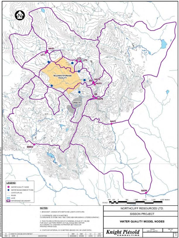
Source: Stantec Consulting Ltd.
- Annual Distribution of Water quality Parameters by Project Phase
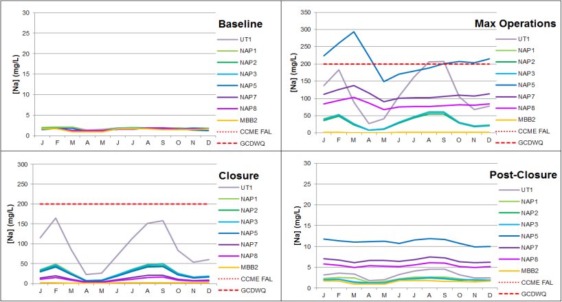
Notes:
- "Baseline" refers to Model Years -1 and -2; "Closure" refers to Year 30; "Post-Closure" refers to Year 50.
- "Maximum Operations" refers to the year for which sodium reaches its maximum value (Year 14 for NAP1, NAP2, NAP3, and MBB2; Year 16 for NAP5, NAP7, and NAP8).
- There is no Canadian Water Quality Guidelines for the Protection of Aquatic Life (Freshwater) guideline for sodium.
- The Guidelines for Canadian Drinking Water Quality for sodium is an aesthetic guideline based on taste and is not within the scale of the baseline and Post-Closure graphs.
- CCME FAL refers to the Canadian Water Quality Guidelines for the Protection of Aquatic Life (Freshwater).
- GCDWQ refers to the Health Canada Guidelines for Canadian Drinking Water Quality.
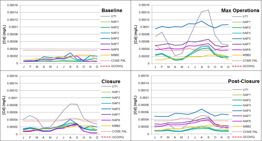
Notes:
- "Baseline" refers to Model Years -1 and -2; "Closure" refers to Year 30; "Post-Closure" refers to Year 50.
- "Max Operations" refers to the year for which cadmium reaches its maximum value (Year 24 for NAP1, NAP2, NAP3, and MBB2; year 20 for NAP5, NAP7, and NAP8).
- The Canadian Water Quality Guidelines for the Protection of Aquatic Life (Freshwater) guideline is hardness-dependent; the guideline shown is for long-term exposure and is calculated for hardness at NAP1; the Canadian Water Quality Guidelines for the Protection of Aquatic Life (Freshwater) guideline for short-term exposure is above the scale of these graphs.
- The Guidelines for Canadian Drinking Water Quality guideline of 0.005 mg/l is not shown on these graphs.
- CCME FAL refers to the Canadian Water Quality Guidelines for the Protection of Aquatic Life (Freshwater).
- GCDWQ refers to the Health Canada Guidelines for Canadian Drinking Water Quality.
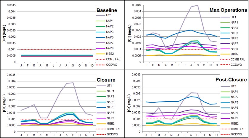
Notes:
- "Baseline" refers to Model Years -1 and -2; "Closure" refers to Year 30; "Post-Closure" refers to Year 50.
- "Max Operations" refers to the year for which chromium reaches its maximum value (Year 26 for all nodes).
- The Canadian Water Quality Guidelines for the Protection of Aquatic Life (Freshwater) guideline for trivalent chromium is 0.0089 mg/l; the Canadian Water Quality Guidelines for the Protection of Aquatic Life (Freshwater) guideline for hexavalent chromium is 0.001 mg/l.
- The Guidelines for Canadian Drinking Water Quality guideline of 0.05 mg/l is not shown on these graphs.
- The current conditions indicate that chromium is below the method detection limit at all nodes.
- CCME FAL refers to the Canadian Water Quality Guidelines for the Protection of Aquatic Life (Freshwater).
- GCDWQ refers to the Health Canada Guidelines for Canadian Drinking Water Quality.
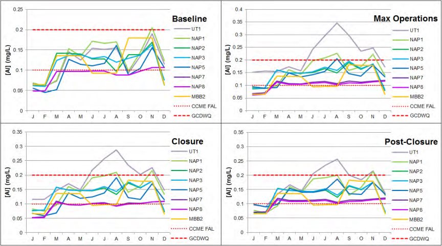
Notes:
- "Baseline" refers to Model Years -1 and -2; "Closure" refers to Year 30; "Post-Closure" refers to Year 50.
- "Max Operations" refers to the year for which aluminum reaches its maximum value (Year 24 for all nodes).
- CCME FAL refers to the Canadian Water Quality Guidelines for the Protection of Aquatic Life (Freshwater).
- GCDWQ refers to the Health Canada Guidelines for Canadian Drinking Water Quality.
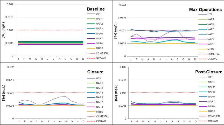
Notes:
- "Baseline" refers to Model Years -1 and -2; "Closure" refers to Year 30; "Post-Closure" refers to Year 50.
- "Max Operations" refers to the year for which selenium reaches its maximum value (Year 24 for NAP1, NAP2, NAP3, and MBB2; Year 11 for NAP5, NAP7, and NAP8).
- The Guidelines for Canadian Drinking Water Quality guideline is 0.01 mg/l and is not within the scale of these graphs.
- The current conditions indicate that selenium is below the method detection limit at all nodes.
- CCME FAL refers to the Canadian Water Quality Guidelines for the Protection of Aquatic Life (Freshwater).
- GCDWQ refers to the Health Canada Guidelines for Canadian Drinking Water Quality.
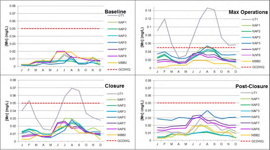
Notes:
- "Baseline" refers to Model Years -1 and -2; "Closure" refers to Year 30; "Post-Closure" refers to Year 50.
- "Max Operations" refers to the year for which manganese reaches its maximum value (Year 14 for all nodes).
- There is no Canadian Water Quality Guidelines for the Protection of Aquatic Life (Freshwater) guideline for manganese.
- GCDWQ refers to the Health Canada Guidelines for Canadian Drinking Water Quality.
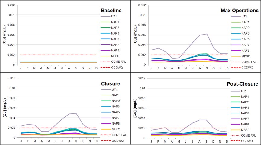
Notes:
- "Baseline" refers to Model Years -1 and -2; "Closure" refers to Year 30; "Post-Closure" refers to Year 50.
- "Max Operations" refers to the year for which copper reaches its maximum value (Year 26 for all nodes).
- The Guidelines for Canadian Drinking Water Quality guideline is 1.0 mg/l and is not within the scale of these graphs.
- Canadian Water Quality Guidelines for the Protection of Aquatic Life (Freshwater) guideline is hardness-dependent, with a minimum of 0.002 mg/l for hardness <83 mg/l.
- CCME FAL refers to the Canadian Water Quality Guidelines for the Protection of Aquatic Life (Freshwater).
- GCDWQ refers to the Health Canada Guidelines for Canadian Drinking Water Quality.
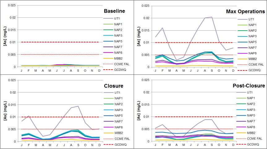
Notes:
- "Baseline" refers to Model Years -1 and -2; "Closure" refers to Year 30; "Post-Closure" refers to Year 50.
- "Max Operations" refers to the year for which arsenic reaches its maximum value (Year 14 for all nodes).
- CCME FAL refers to the Canadian Water Quality Guidelines for the Protection of Aquatic Life (Freshwater).
- GCDWQ refers to the Health Canada Guidelines for Canadian Drinking Water Quality.
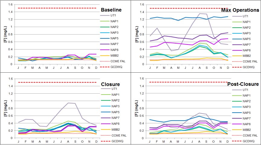
Notes:
- "Baseline" refers to Model Years -1 and -2; "Closure" refers to year 30; "Post-Closure" refers to Year 50.
- "Max Operations" refers to the year for which fluoride reaches its maximum value (Year 24 for NAP1, NAP2, NAP3, and MBB2; Year 11 for NAP5, NAP7, and NAP8).
- CCME FAL refers to the Canadian Water Quality Guidelines for the Protection of Aquatic Life (Freshwater).
- GCDWQ refers to the Health Canada Guidelines for Canadian Drinking Water Quality.
Appendix H Summary of Key Concerns Raised during Consultations with Maliseet and Mi'gmag First Nations
|
First Nation |
Subject |
Comment or Concern |
Summary of Proponent's Response |
Canadian Environmental Assessment Agency Response |
|---|---|---|---|---|
|
Madawaska, Woodstock and St. Mary's First Nations. The Assembly of First Nation Chiefs in New Brunswick |
Water Quality |
Concern about water quality and lack of commitment to adhering to Canadian Water Quality Guidelines for the Protection of Aquatic Life (Freshwater) |
The proponent expects that site-specific water quality objectives would be determined by the Province of New Brunswick during the permitting process, and that these objectives would be established to ensure that the Project would not cause significant adverse environmental effects during operations, closure and post-closure. The proponent is committed to operating and closing the Project without causing significant adverse environmental effects, and would comply with site-specific water quality objectives the Province of New Brunswick deems appropriate for protecting the aquatic environment. A follow-up program is planned to verify impact predictions in relation to water quality, the proponent would respond to any elevated concentrations of concern through adaptive management and implementation of additional mitigation as necessary so as to remain in compliance with environmental legislation. |
The Province of New Brunswick would require that water quality meet Canadian Council of Ministers of Environment guidelines unless baseline concentrations of certain parameters already exceeds these guidelines; in which case the Province of New Brunswick would adopt the Canadian Council of Ministers of Environment specified process for developing site-specific water quality objectives. Water quality objectives would be established through the Province of New Brunswick's Water Quality Approvals to Construct and Operate. As part of its conditions of environmental impact assessment (EIA) approval, the Province of New Brunswick would require the proponent to provide Water Quality Management and Monitoring Plans to the Province of New Brunswick during the final engineered design phase. Based on advice from Environment and Climate Change Canada and the Province of New Brunswick, the Canadian Environmental Assessment Agency (Agency) is satisfied that the provincial approach to establishing water quality objectives for the Project would be sufficient to not result in significant effects on water quality. |
|
Madawaska, Woodstock and St. Mary's First Nations. The Assembly of First Nation Chiefs in New Brunswick |
Water Quality |
Concern that the technology used for the long term treatment of water from pit-lake is unproven and insufficient |
The process planned for post-closure treatment of water in pit-lake is the same technology that is planned for the operations phase, with the exception that, during post-closure, pit-lake would serve the same purpose as the clarifier during operations. It should be noted that in-pit treatment would not be needed for nearly 40 years after operation commences. During that time, pilot testing and in-pit testing while the pit fills could be performed to refine the design and ensure that treatment methodology is optimized and suitably protective of the downstream environment. |
The Province of New Brunswick would establish water quality objectives through the Province's Water Quality Approvals to Construct and Operate Additionally, as part of its conditions of EIA approval, the Province of New Brunswick would review the final engineered design of all facility components, including treatment systems. Based on the expert opinions of the Province of New Brunswick, Environment and Climate Change Canada and Natural Resources Canada, along with provincial requirements concerning water quality objectives, the Agency is satisfied with the approach to managing the long term treatment of water and that the Project is not likely to result in significant effects on water quality. |
|
Madawaska, Woodstock and St. Mary's First Nations. The Assembly of First Nation Chiefs in New Brunswick |
Water Quality |
Concern about the volume and effects of seepage from the tailings storage facility. |
The proponent stated that the storage of tailings and waste rock within the tailings storage facility may result in seepage of metal enriched water through the embankments toward local streams and into the groundwater under the tailings storage facility and down gradient, following groundwater pathways to local streams. Perimeter engineered drainage collection channels at the toe of the tailings storage facility embankments, and lined water management ponds, would collect most of this seepage. However, some seepage would escape to the receiving environment, potentially affecting down gradient/downstream water quality. Groundwater pump-back wells would be installed below the northwestern tailing storage facility embankment to collect some groundwater seepage, with pumping back to the tailings storage facility to reduce water quality effects in Napadogan Brook. Groundwater quality monitoring wells would also be established below the water management ponds, and could be converted to pump-back wells if required to ensure downstream water quality objectives would be met. The proponent stated that groundwater seepage from beneath the tailings storage facility into receiving waters would continue in perpetuity. Seepage water quality is expected to improve in the long term as the sources of metals within the tailings storage facility are depleted. Water quality monitoring would continue post-closure until such time that the water quality is acceptable. The proponent confirmed that further field investigation and assessment would be undertaken during detailed engineering in order to collect additional geotechnical information and groundwater level data. This data would be included in additional two- and three-dimensional numerical modelling of the tailings storage facility and surrounding areas in order to refine understanding of groundwater flow within the tailings storage facility through the Project lifecycle and improve tailings storage facility design. Special measures to mitigate seepage in areas that require further engineered solutions, such as grouting of bedrock would be undertaken as needed and specifics would be developed in the engineering phases of the Project. |
Natural Resources Canada stated that the proponent had undertaken a reasonable assessment of the movement of groundwater from the tailings storage facility. As part of its conditions of EIA approval, the Province of New Brunswick would require that the proponent conduct further mapping, drilling and analysis of the base of the proposed tailing storage facility and its dam to further assess the potential for water conduits from the tailings storage facility to groundwater. This additional work would be required prior to construction. Furthermore the Province of New Brunswick would require the proponent to monitor groundwater and validate the design of potential seepage interception wells as a component of the Water Monitoring and Management Plans. The Province of New Brunswick would require water quality to meet Canadian Council of Ministers of the Environment guidelines unless baseline concentrations exceed these guidelines; in which case the Province of New Brunswick would adopt the Canadian Council of Ministers of the Environment specified process for developing site-specific water quality objectives. Based on the expert opinions of the Province of New Brunswick, Environment and Climate Change Canada and Natural Resources Canada, along with the Province of New Brunswick's conditions of EIA approval, the Agency is satisfied that Project is not likely to result in significant effects on water quality. |
|
St. Mary's First Nations. |
Drinking water |
First Nations use springs in the project area for drinking water and are concerned about groundwater contamination. |
The proponent stated that predicted exceedances of the Guidelines for Canadian Drinking Water Quality are aesthetic in nature and would not cause adverse health effects in humans. The Human Health and Ecological Risk Assessment conducted for the proponent's EIA Report considered use by First Nations, and found that significant adverse environmental effects on human and aquatic health were unlikely. |
As part of part of its conditions of EIA approval, the Province of New Brunswick would require the proponent to undertake pre-construction surveys to establish quality of baseline water supplies within the local assessment area, including at camp lots and recreational campsites. In the event of complaints that a water supply has been impacted, the proponent would be required to investigate and implement mitigation should it be demonstrated that the Project has impacted the supply. To further mitigate potential effects on human health resulting from changes in water quality, the Province of New Brunswick stated that it would establish specific water quality parameters with which the proponent must comply. The starting point for establishing water quality objectives would be the Canadian Environmental Quality Guidelines for the Protection of Aquatic Life (Freshwater). Where necessary, site specific water objectives would consider the most sensitive water uses, including human consumption. Based on the expertise provided by Health Canada and the Province of New Brunswick, the Agency is satisfied that Project it not likely result in significant effects on water quality, including water sources that may be used for drinking water, given the implementation of proposed mitigation. |
|
Madawaska, Woodstock and St. Mary's First Nations. The Assembly of First Nation Chiefs in New Brunswick |
Water Quality |
Concern about the need to treat water in perpetuity. |
The cost of water treatment before discharge, for as long as necessary, has been included in the closure bonding estimated at $50 million. The proponent would continue to advance the Project design through basic engineering, refining the predictive water quality modelling and consequent waste and water management and treatment needs. This would allow refinement of the expected duration of water treatment, and it is likely that perpetual treatment would not be required. Governments would be notified of the results should it result in any substantive changes to the Project and its potential environmental effects. The proponent expects that objectives for discharge and receiving water quality would be established by the Province of New Brunswick. |
The Province of New Brunswick indicated that it was satisfied with the conceptual information presented in the proponent's EIA Report and generally agreed with its findings. The Province of New Brunswick would require water quality to meet Canadian Council of Ministers of the Environment guidelines unless baseline concentrations exceeds guidelines; in which case the Province of New Brunswick would adopt the Canadian Council of Ministers of the Environment specified process for developing site-specific water quality objectives. As part of its conditions of EIA approval, the Province of New Brunswick would require the proponent to develop a Financial Security Plan to include a long term water treatment security prior to tailings being deposited into the tailings storage facility. This would cover the annual operating and maintenance cost of the water treatment plant and associated monitoring requirements in perpetuity. |
|
Madawaska, Woodstock and St. Mary's First Nations. The Assembly of First Nation Chiefs in New Brunswick |
Water quality-Acid Rock Drainage/Metal Leaching |
The proponent's analysis of potential acid rock drainage and metal leaching from waste rock, tailings, the pit wall, and overburden were under-predicted and may pose a serious risk to aquatic life. |
The proponent stated that a number of conservative acid rock drainage and metal leaching assumption were used to develop water quality predictions. The proponent committed to ongoing geochemical characterisation of waste streams and ore so as to enable appropriate management. It stated that a detailed waste rock management plan would be developed as part of permitting requirements to guide mine operations. As part of this plan, continued sampling and analysis of the final pit wall would be undertaken if acid generation and metal leaching were impacting pit-Lake water quality. In the long-term, seasonal in-pit water treatment would occur, including lime addition as necessary to ensure acceptable water alkalinity. Treatment would continue as long as required to ensure water quality was acceptable for discharge. |
Natural Resources Canada stated that the proponent appears to have generally followed an appropriate methodology in characterizing acid rock drainage and metal leaching potential. The Province of New Brunswick stated that the information and analysis on the potential for acid generation were adequate. As part of its conditions of EIA approval, the Province of New Brunswick would require that revised water quality modelling results be submitted prior to applying for approvals to construct and operate. The revised modelling would be required to consider: loading to seepage from tailings and waste rock pores deposed of in the tailings storage facility; potential acidity of the high pit wall; transient loading from seepage through ore stockpiles on site during operations; and an extended simulation period to account for potential acidification of pit high wall rock that would initiate after 100 years. Based on the expert opinions of Environment and Climate Change Canada, Natural Resources Canada, and the Province of New Brunswick and on the Province of New Brunswick's EIA approval conditions, the Agency is satisfied that Project is not likely to result in significant effects on water quality. |
|
Madawaska, Woodstock and St. Mary's First Nations. The Assembly of First Nation Chiefs in New Brunswick |
Water quality-Acid Rock Drainage/Metal Leaching |
Concerns about the proponent's ability to maintain saturated conditions over potential acid generating tailings to prevent metal leaching. |
The proponent stated that the water balance model showed a minimum pond volume of approximately four cubic megameters could be maintained under extreme dry scenarios during operations; this would be a sufficient volume of water to ensure continued saturation. In addition, modelling conducted for the tailings storage facility predicted that it would have a surplus of water under all conditions after closure. In addition, the potentially acid generating waste rock and tailings would be encapsulated within non-potentially acid generating tailings after closure. |
Natural Resources Canada stated that the proponent followed an appropriate methodology in characterizing acid rock drainage and metal leaching potential. As part of its conditions of EIA approval, the Province of New Brunswick would require that a Water Monitoring and Management Plan be developed. This would include a requirement to use water quantity and quality data to regularly review and adapt the site groundwater flow model and the site water balance. Based on the expert opinions of Environment and Climate Change Canada, Natural Resources Canada, and the Province of New Brunswick and on the Province of New Brunswick's EIA approval conditions, the Agency is satisfied with the proponent's methodology and that Project is not likely to result in significant effects on water quality. |
|
Madawaska, Woodstock and St. Mary's First Nations. The Assembly of First Nation Chiefs in New Brunswick |
Fish and fish habitat |
Concern that there was no Maliseet and Mi'gmag First Nations input into the fisheries compensation plan. |
The proponent stated that the potential Project-related environmental effects on fish and fisheries have been an ongoing topic of discussion with First Nations through the First Nations Environmental Assessment Working Group and other engagement activities. It stated that it has made, and continues to make, best efforts to engage with First Nations about potential fish habitat compensation opportunities. A conceptual plan was presented in the proponent's EIA Report to allow a detailed discussion with appropriate regulators and First Nations to commence. |
Information provided by the proponent on the offsetting for the loss of fish habitat as a result of the Project is satisfactory for the environmental assessment process. Fisheries and Oceans Canada advised that the proponent's proposal to offset the direct and indirect loss of fish habitat would result in no residual change in fish habitat (and associated changes to fish productivity) arising from the Project. Fisheries and Oceans Canada indicated that further information and consultation with Maliseet and Mi'gmag First Nations on the fisheries offsetting plan would be undertaken in the regulatory permitting phase should the project gain approval. |
|
Madawaska, Woodstock and St. Mary's First Nations. The Assembly of First Nation Chiefs in New Brunswick |
Fish and fish habitat |
Concern about the potential loss of quality fish habitat for Atlantic Salmon and Brook Trout. |
The proponent stated that construction of the Project would result in the direct loss of 3.72 hectares of fish habitat as a result of infilling of watercourses in the tailings storage facility and draining of watercourses in the open pit. Indirect losses of 2.67 hectares of fish habitat are predicted due to reduced stream flow in segments of Bird Brook, Sisson Brook, and further downstream in Napadogan Brook (i.e. while the tailing storage facility is being filled with water). As required by Fisheries and Oceans Canada, the proponent would implement a Fish Habitat Offsetting Plan to mitigate the loss of fish habitat, including direct loss from construction of the pit, tailing storage facility and roads, and indirect losses from reduced flows and fish passage limitations. With this authorization and associated compensation for effects of direct habitat loss, the proponent predicted that residual adverse effects would not be significant. |
Fisheries and Oceans Canada confirmed that the proposed mitigation measures, including offsetting plans, were adequate to avoid significant adverse effects on fish and fish habitat. The proponent would be required to submit a detailed offsetting (compensation) plan in accordance with Fisheries and Oceans Canada's Fisheries Productivity Investment Policy: A Proponent's Guide to Offsetting (November 2013) to counterbalance unavoidable serious harm to fish and the loss of fisheries productivity resulting from the Project. It would also be required to develop a detailed follow-up monitoring program to assess the effectiveness of mitigation techniques, accuracy of predicted fish mortalities and habitat loss, and the effectiveness of offsetting measures. As part of its conditions of EIA approval, the Province of New Brunswick would require the proponent to develop adaptive monitoring plans for aquatic resources, specifically Atlantic Salmon, in consultation with First Nations to construction. The Agency concurs with Fisheries and Oceans Canada that the Project is not likely to result in significant adverse effects on fish and fish habitat after taking into account the implementation of proposed mitigation measures. |
|
Madawaska, Woodstock and St. Mary's First Nations. The Assembly of First Nation Chiefs in New Brunswick |
Wildlife and Wildlife Habitat |
Concern that the Project would impact the abundance of traditionally important species such as deer and moose. |
The proponent stated that the majority of species (e.g. moose, white tailed deer) identified as important to First Nations people are common within the Crown land block and New Brunswick. The proponent predicted that the Project would not cause a decline in abundance or change in distribution of any wildlife species of traditional importance. Adverse environmental effects of the Project on wildlife would be minimized or avoided through a number of mitigation measures including timing restrictions on clearing, and Project design. While the terrestrial environment may be sensitive to perturbation, secure and non-secure wildlife populations would not change substantively within the greater Central Uplands Ecoregion (Madawaska Uplands portion) and/or Valley Lowlands Ecoregion and the province as a result of the Project. Dust, noise and other Project emissions would be largely limited to the project site and the immediate area surrounding it, and would be monitored and managed during construction and operation of the Project to ensure that their environmental effects on land and resources outside the Project footprint are avoided or minimized and not significant |
The Province of New Brunswick stated that it was satisfied with the information provided by the proponent in relation to wildlife and wildlife habitat and generally agrees with the proponent's findings. As part of its conditions of EIA approval, the Province of New Brunswick would require that the proponent, in consultation with First Nations, collect, submit and interpret quantitative baseline data concerning use of the local assessment area by animal species of importance to First Nations (e.g. moose, deer) prior to construction. This information would be used as a basis for confirming impact predictions. Follow-up programs would be developed based on this information. The Agency is satisfied that, taking the implementation of mitigation measures into account, the Project is not likely to result in significant effects on wildlife and wildlife habitat, including those that are important for First Nation groups. |
|
Madawaska, Woodstock and St. Mary's First Nations. The Assembly of First Nation Chiefs in New Brunswick |
Wildlife and Wildlife Habitat |
Potential interaction between wildlife and tailing ponds including the ammonium paratungstate plant waste cells. |
The proponent stated that during construction and operations, several project components (e.g. explosives plant and magazine, power substation, gated entry along the access road, and ammonium paratungstate plant waste cells within the tailings storage facility) would be surrounded by fencing. Berms or fencing around the tailings storage facility, quarry, and open pit are not planned during operations since these areas would be actively worked and growing in size over the life of the Project. The proponent maintained that wildlife would generally avoid the area during construction and operation as noise, lighting, equipment and personnel presence would be ongoing. During decommissioning and closure, fencing around many of the project components would be removed, but the open pit and quarry would be fenced to prevent human and wildlife access. The proponent also committed to working with the Province of New Brunswick to develop specific measures in the environmental management plan for addressing wildlife interactions in the project development area. |
The Province of New Brunswick stated that it was satisfied with the information provided by the proponent in relation to wildlife and wildlife habitat and generally agrees with the findings of the proponent's EIA Report. As part of its conditions of EIA approval, the Province of New Brunswick would require the proponent to develop an adaptive monitoring program in consultation with First Nations and regulatory department. This program would include monitoring and adaptive management in relation to predictions concerning s wildlife access to the tailing storage facility. In addition, the Province of New Brunswick would require the proponent to develop an emergency and/or contingency plan for the protection of wildlife, including waterfowl. This would have to be completed prior to construction. The Agency is satisfied that, taking the implementation of mitigation measures into account, the Project is not likely to result in significant effects on wildlife and wildlife habitat, including those that are important for First Nation groups. |
|
Madawaska, Woodstock and St. Mary's First Nation |
Current use of land and resources/Vegetation |
Concern regarding the loss of plant gathering areas and hard wood stands of importance to the Maliseet |
Most vegetation disturbance would be limited to the 1,253 hectares of the project development area, that First Nations would not be able to use during the life of the Project and for some time into closure. It is expected that First Nations would continue to use the rest of the Crown land block, and the regional assessment area, and traditional territory as a whole for traditional purposes. The proponent indicated that species of value to First Nations are available in surrounding areas. The proponent would provide an opportunity for First Nations to collect plants of importance within the project footprint prior to construction, and would work with First Nations to design the closure plan to optimize the availability of reclaimed lands for traditional activities. Though the proponent's EIA Report confidently predicted no significant environmental effects to traditional foods, the proponent would undertake monitoring of potential effects at two to three traditional use sites identified by First Nations for harvesting of country foods (e.g. fiddleheads, berries, medicinal plants) prior to construction, and again within five years of the start of operations. |
The Province of New Brunswick stated that it was satisfied with the information provided by the proponent in relation to vegetation and generally agrees with the findings of the proponent's EIA Report. As part of its conditions of EIA approval, the Province of New Brunswick would require the proponent to collect additional baseline (pre-construction) surveys with input from First Nations on vegetation harvested or grown for subsistence or medicinal purposes or obtained from recreational activities within the local assessment area. The baseline information would then be used to develop a traditional and country foods monitoring program to be undertaken during project operation and decommissioning/post-closure. The Agency has been informed that the Province of New Brunswick and Maliseet First Nations are negotiating mitigation and accommodation for project effects. Additional mitigation and accommodation may result from these discussions. |
|
Madawaska, Woodstock and St. Mary's First Nations. The Assembly of First Nation Chiefs in New Brunswick |
Vegetation |
Maliseet and Mi'gmag First Nations stated that traditional use of plants including Black Ash (Fraxinus nigra) and Butternut (Juglans cinerea) (Species at Risk Act endangered) had not been assessed in the environmental Impact assessment. |
Most vegetation disturbance would be limited to the 1,253 hectares of the project development area, which First Nations would not be able to use during the life of the Project and for some time into closure. It is expected that First Nations would continue to use the rest of the Crown land block, and the regional assessment area, and traditional territory as a whole for traditional purposes. Additional information was provided by the proponent on the distribution of plants named in the Indigenous Knowledge Study as being important to First Nations to demonstrate that these species are not unique to the project site, are available in other areas surrounding the site, and are recognized as secure populations by the Atlantic Canada Conservation Data Centre. The proponent committed to provide an opportunity to collect plants of importance within the project footprint prior to construction, and work with First Nations to design the closure plan to optimize the availability of reclaimed lands for traditional activities. |
The Province of New Brunswick stated that it was satisfied with the information provided by the proponent in relation to vegetation and generally agrees with the findings of the proponent's EIA Report. As part of its conditions of EIA approval, the Province of New Brunswick would require the proponent to conduct additional baseline (pre-construction) surveys with input from First Nations on vegetation harvested or grown for subsistence or medicinal purposes or obtained from recreational activities within the local assessment area. The baseline information would then be used to develop a traditional and country foods monitoring program to be undertaken during operations and decommissioning/post-closure. The Agency is satisfied that the proponent's methodology took into account vegetation of importance to First Nations. |
|
Madawaska, Woodstock and St. Mary's First Nations. The Assembly of First Nation Chiefs in New Brunswick |
Current use of land and resources |
Concern about potential loss of land and resources for traditional purposes and its cultural significance. |
The proponent stated that it has received no information through its extensive engagement activities with First Nations, or from its Indigenous Knowledge Study, about specific sites related to traditional use within the project development area that are important for First Nations cultural, spiritual or ceremonial purposes. The otherwise available information relates entirely and only to sites or areas of various land and resource uses (e.g. hunting, fishing, trapping, gathering and harvesting timber) in and around the project site, and in the larger contiguous Crown land block in which the project site is located. Thus, it is reasonable to conclude that the cultural experience associated with traditional First Nation use would only be affected by the Project to the extent that such resource use would be affected, and not as a result of Project-related environmental effects on specific sites within the project footprint. Regarding the availability of resources in the larger contiguous Crown land block in which the project site is located, the project site is about 1.9 percent of the Crown land block area. Resources of interest to First Nations are common throughout the Crown land block, and the project site does not provide resources that are unique within the Crown land block. Thus, there was no reason to presume that traditional land and resource uses in the local assessment area would differ substantially from such uses in the larger block of Crown land in central New Brunswick. The proponent concluded that the environmental effects of the Project on the various other biophysical valued components in the assessment area that may be used by First Nation people (e.g. fish, wildlife, vegetation) are not significant. As a general commitment, the proponent stated that it would continue to work with interested First Nations throughout the life of the Project to identify and implement reasonable measures to monitor and avoid or mitigate project-related environmental effects on the contemporary exercise of asserted or established Aboriginal or treaty rights. |
The Project would result in the temporary or permanent loss of approximately 1,442 hectares of Crown land that is within an area that has been historically considered as the traditional territory of the Maliseet First Nations. The Agency is of the view that because the current use of the area by First Nations cannot solely be defined by resource availability but also needs to account for cultural values and traditional knowledge, the mitigation measures proposed by the proponent for biophysical valued components do not fully mitigate effects on the current use of lands and resources. The Province of New Brunswick in their General Review Statement of April 2015 stated that residual environmental effects would be present and recommended that government consider appropriate accommodation to offset any residual effects The Agency has been informed that the Province of New Brunswick and Maliseet First Nations are negotiating mitigation and accommodation for project effects. Additional mitigation and accommodation may result from these discussions. |
|
Madawaska, Woodstock and St. Mary's First Nations. The Assembly of First Nation Chiefs in New Brunswick |
Heritage Resources |
Concern that the baseline for heritage resources failed to adequately characterise the potential for sites of cultural and archeological importance. |
Shovel testing in the areas of high archaeological potential was undertaken between 2012 and 2015 resulted in the discovery and delineation of two archaeological sites within the proposed mine area, one within the tailings storage facility and one in the open pit. A total of 614 potential artifacts were submitted to the Province of New Brunswick's Archaeological Services. Provincial staff, along with independent and First Nations experts, confirmed that 26 of the potential artifacts submitted were archeological artifacts, with the remaining objects being shaped as the result of natural processes or twentieth century forestry road building activity in the area. The proponent is committed to working with New Brunswick's Archaeological Services and Maliseet and Mi'gmag First Nations to fully understand and preserve these and other archeological resources that may be found. |
To ensure a sufficient characterization of the heritage resources affected by the Project, the Agency asked for further field work (test pitting) in order to further delineate archeological resources in the Project area, and update the analysis, mitigation measures and follow-up. The Province of New Brunswick conducted a program to complete the outstanding archaeological assessment within the project development area in partnership with the six Maliseet First Nations (Kingsclear, St Mary's, Madawaska, Oromocto, Tobique, and Woodstock). In the fall of 2015, a further 4500 test pits in the vicinity of the proposed tailing storage facility and open pit were completed. Further analysis of the potential impacts was undertaken by the Province of New Brunswick who concluded that the mitigation proposed would address the physical impact of the Project on the identified heritage resources. As part of its conditions of EIA approval, the Province of New Brunswick would require the proponent to provide a site-specific mitigation plan for any heritage resources discovered within the project footprint, prior to construction, and provide the framework for appropriate process, including consultation, for any discoveries throughout the project life. This condition also requires the proponent to fund all activities associated with heritage resources mitigation. The Agency considered the results of the additional test pitting and assessment in the analysis of the effects of the Project on heritage resources. Based on expert advice provided by the Province of New Brunswick, the Agency is satisfied that sufficient baseline information exists to draw conclusions about the potential significance of effects on heritage resources. |
|
Madawaska, Woodstock and St. Mary's First Nations. The Assembly of First Nation Chiefs in New Brunswick |
Air Quality- County foods |
Concern about dust from the road and effects from the direct deposition of ore dust on vegetation consumed by Maliseet and Mi'gmag First Nations |
Maximum ground-level concentrations of particulate matter (PM) and PM10 may be above objectives and standards on occasion, due to fugitive emissions resulting from road dust on off-site access roads; however, the proponent predicted that exceedances would be localized, infrequent, brief, and that mitigation measures for the atmospheric environment would help address issues related to dust. The proponent stated that it was unlikely that ore dustfall from the Project would affect the soil concentrations and vegetation trace metals concentrations including edible berries along roads. The proponent committed to monitoring potential effects at two to three traditional use sites identified by First Nations for harvesting of country foods (e.g. fiddleheads, berries, medicinal plants), prior to construction, and again within five years of the start of operation. |
Environment and Climate Change Canada agreed that the dust mitigation proposed was appropriate and agreed with the follow-up monitoring proposed. Health Canada recommended that vegetation consumed by the public and/or First Nations be resampled at the onset of operations; to verify baseline values of arsenic, chromium, manganese and thallium to confirm the estimations and assumptions as presented in the human health and ecological risk assessment. Additionally, Health Canada recommended sampling of vegetation for specific metals in dusts, in the event of public complaints about the contamination of vegetation. As part of its conditions of EIA approval, the Province of New Brunswick would require the proponent to conduct additional modelling of aerial dust deposition on vegetation. Foods that are used by First Nations would be monitored for metals, including arsenic, chromium, manganese and thallium in order to confirm the predictions and assumptions. The additional dust deposition modeling and contaminant levels baseline information would then be used to develop a traditional and country food monitoring program, to be undertaken during project operations and decommissioning/post-closure. In addition, the Province of New Brunswick would require the proponent to develop a reporting system and procedure to be followed in the event of complaints received from First Nations or the public regarding the quality or taste of traditional or country foods. Complaints would be handled through the Public Complaints Protocol, and may be responded to by sampling the reported food for contaminants of potential concern (primarily metals). Results would be compared to baseline data, the predicted values presented in the health and ecological risk assessment, and applicable health-based criteria for acceptable concentrations of contaminants of potential concern in foods. Further mitigation measures would be required by the proponent if monitoring were to indicate increased contaminant concentrations. As part of its conditions of EIA approval, the Province of New Brunswick would also require the development of a Dust Suppression Plan. The Agency is satisfied that Health Canada's recommendations would be considered in the provincial requirements for country food monitoring. Taking into account the implementation of mitigation measures and expert advice, the Agency is satisfied that the Project is not likely to result in significant effects on human health, including through country foods. |
|
Madawaska, Woodstock and St. Mary's First Nations. The Assembly of First Nation Chiefs in New Brunswick |
Air Quality-Follow-up |
Concern about a lack of a proposed air quality monitoring program to confirm compliance with relevant guidelines and impact predictions. |
Follow-up measures are solely aimed at verifying the environmental effects predictions or the effectiveness of mitigation (e.g. in cases when there is less than a high level of confidence in the environmental effects predictions) or monitoring requirements that are already codified and defined by legislation. This does not preclude the authority of any regulatory agency to impose whatever monitoring or other requirements they require. In the case of the atmospheric environment, environmental effects predictions were made with a high level of confidence and the mitigation measures are well understood. Therefore no follow-up was required. Furthermore, no requirements for such monitoring are specifically defined for mining or industrial facilities in legislation or regulations. Those requirements are defined on a case-by-case for specific facilities as part of the Province of New Brunswick's Approval to Operate, but those specific requirements have not yet been defined by regulatory authorities. |
The proponent would be required to develop a comprehensive air quality monitoring plan as a component of the Province of New Brunswick's Air Quality Approval to Operate under its Air Quality Regulations, under the Clean Air Act. As part of its conditions of EIA approval, the Province of New Brunswick would require the proponent to develop a Public Complaints Protocol, prior to construction, to address complaints and concerns associated with project activities, including mandatory reporting of all complaints, corrective actions and/or proponent response to complaints. The Agency is satisfied that an air quality monitoring program would be developed. |
|
Madawaska, Woodstock and St. Mary's First Nations. The Assembly of First Nation Chiefs in New Brunswick |
Air Quality-Visibility |
Concern that dust emissions would impact visibility and impair use of the project area by Maliseet and Mi'gmag First Nations |
The quantities of NO2, volatile organic compounds, and particulate matter predicted to be released are relatively low in comparison with other industrial facilities in New Brunswick; even with those industrial facilities, substantive issues with visibility have not occurred. Although elevated emissions of particulate matter may occur on occasion within the project development area, given the nature of the releases (fugitive dust) and the large size of the project development area, reduced visibility (due to PM emissions) is not likely to occur beyond the project development area, a largely forested environment, if it occurs at all. Dust mitigation would be employed to maintain acceptable dust levels that could otherwise affect visibility. The proponent has committed to investigating visibility complaints should they occur. |
Environment and Climate Change Canada and the Province of New Brunswick agreed with the proponent's predictions related to visibility. As part of its conditions of EIA approval, the Province of New Brunswick would require the development of a Dust Suppression Plan. Furthermore, the proponent would be required to develop an air quality monitoring plan as a component of the Province of New Brunswick's Air Quality Approval to Operate under its Air Quality Regulations, under the Clean Air Act. As part of its conditions of EIA approval, the Province of New Brunswick would require the proponent to develop a Public Complaints Protocol, prior to commencement of construction, to address complaints and concerns associated with project activities, including mandatory reporting of all complaints, corrective actions and/or proponent response to complaints. The Agency, based on expertise provided by Environment and Climate Change Canada and the Province of New Brunswick, and having taken into account the proposed mitigation, concludes that the Project is unlikely to result in significant environment effects on the atmospheric environment. |
|
Madawaska, Woodstock and St. Mary's First Nations. The Assembly of First Nation Chiefs in New Brunswick |
Air Quality-Odour |
Concern about odour from the site and the need for complaint driven response process to be outlined |
The proponent stated that it modelled odour emissions as part of the assessment. Emissions of H2S and selected volatile organic compounds were modelled from the ammonium paratungstate plant during operations. Based on the modelling results, the odour threshold for H2S was exceeded infrequently near the ore processing plant (i.e. within 20 meters). Thus, based on the assessment, odour is not likely to be an issue, either off-site or on-site. The proponent would have public contact numbers available that can be used to communicate any questions or concerns about the operation. The proponent would develop a complaints handling procedure. |
As part of its conditions of EIA approval, the Province of New Brunswick would require the proponent to develop a Public Complaints Protocol, prior to construction, to address complaints and concerns associated with project activities, including mandatory reporting of all complaints, corrective actions and/or proponent response to complaints. Environment and Climate Change Canada was satisfied with proponent's assessment of odour and stated that the provincial complaints handling procedure and reporting requirements would be sufficient to address potential complaints. The Agency considered changes in odour as part of its analysis of the effects on the atmospheric environment. Based on expertise provided by Environment and Climate Change Canada and the Province of New Brunswick, and having taken into account the implementation of mitigation, the Agency concludes that the Project is unlikely to result in significant environment effects on the atmospheric environment. |
|
Madawaska, Woodstock and St. Mary's First Nations. The Assembly of First Nation Chiefs in New Brunswick |
Air Quality-Noise |
Maliseet and Mi'gmag First Nations raised concerns regarding noise from the Project, particularly its effects on the enjoyment of the project site which is valued for its peacefulness and tranquility. |
With the exception of sound emissions from blasting events, activities during construction and operations are not expected to be noticeable at the nearest recreational campsite. Mitigation measures include enclosing processing equipment in buildings and using mufflers. Blasting in the open pit is expected to once or twice a day, approximately two to three days per week (and in the quarry once per week for three months per year. Blasting would be audible at the recreational camps, however the period would be brief (approximately two seconds at a time) and vibration amplitude small (similar to the vibration caused by a large bulldozer operating 7.6 metres away from a receptor). Mitigation measures include, avoiding night time blasting, whenever feasible; minimizing the frequency of blasts; and notifying nearby residents and camp owners of the blasting schedule. |
As part of its conditions of EIA approval, the Province of New Brunswick would require a Communications Protocol that would include notifying First Nations about blasting schedule and planned blasting activities. Furthermore, a Public Complaints Protocol would be developed to address complaints and concerns associated with the Project, including noise complaints. The protocol would, include mandatory reporting, corrective actions and/or proponent response to complaints. Additionally, the proponent would be required to develop a First Nations engagement strategy that would include compensation for relocation of existing individual or community camp sites within the project development area and within the local assessment area to First Nation individuals on Crown land should the Project impact use of camp sites. The Agency considered changes in noise levels as part of its analysis of effects on the atmospheric environment. The Agency, based on expertise provided by Environment and Climate Change Canada, Health Canada, and the Province of New Brunswick, and having taken into account the proposed mitigation, concludes that the Project is unlikely to result in significant adverse environment effects on the atmospheric environment, including the acoustic environment. |
|
Madawaska, Woodstock and St. Mary's First Nations. The Assembly of First Nation Chiefs in New Brunswick |
Accidents and Malfunctions |
Concern about the potential impact on the aquatic environment, specifically, salmon and eels, of a catastrophic spill. |
The proponent stated that it conducted an analysis of loss of containment of the tailings storage facility by breach of the tailings embankment as a result of an extreme earthquake or flood event outside of the conservative design criteria for the facility. The release of tailings and other sediment would likely affect the channel and flood plain of Napadogan Brook, and possibly Nashwaak River. The erosion and deposition of natural material eroded by the flood and tailings would likely cover and infill the channel and floodplains, affecting water resources and the aquatic-, terrestrial-, vegetated- and wetland environments. The flooding and deposition may interfere with bridge crossings and related infrastructure and would like interfere with various land uses. Public health and safety might be affected through contamination of water or through hazardous conditions associated with land use and activities or transportation. Environmental effects of such a major failure of containment in the tailings storage facility embankment would be substantive and significant, especially for the aquatic environment. However, the proponent stated that the tailings storage facility has been designed, and would be constructed and operated in consideration of current design standards, to meet conservative factors of safety appropriate to a modern tailings storage facility in New Brunswick under rigorous regulation by the New Brunswick Department of Energy and Mines and Department of Environment and Local Government. In these conditions, a major failure of the tailing storage facility embankment has an extremely low likelihood of occurrence (annual probability of failure of between 1-in-1 million to 1-in-10 million). |
The Province of New Brunswick contracted independent expert reviews of the proposed water treatment facility and program, as well as a review of the general design of the tailings storage facility. As a condition of EIA approval, the Province of New Brunswick would require the proponent to establish and fund an independent review board to evaluate the design, construction, and performance of the tailing storage facility. Furthermore, the Province of New Brunswick would require, as part of the Environmental Management Plan, a tailing storage facility operations, maintenance and surveillance manual (detailing safety inspection, compliance monitoring, and reporting) to be reviewed and revised every five years in accordance with the Canadian Dam Safety Guidelines. In addition, as part of its conditions of EIA approval, the Province of New Brunswick would require the proponent to develop and submit for review and approval an Emergency Preparedness and Response Program for the Project, that would consider scenarios such as overtopping and partial or full breach of the tailing storage facility. Tailings storage facility failure modelling on the final engineered design and for each approved lift of the tailing storage facility structure, inclusive of a variety of scenarios, must be included in the Emergency Preparedness and Response Program. The Agency considers that loss of containment of the tailing storage facility would result in significant effects on the aquatic environment. However, in consideration of the design standards and follow-up and provincial requirements, such an event is unlikely. |
|
St. Mary's First Nation |
Accidents and Malfunctions |
The assessment must consider the report of the Mount Polley tailings storage facility breach. |
The proponent reviewed the reported causes of the Mount Polley tailings facility failure, and concluded that its current design and operational plans would ensure that these causes would be avoided at the Sisson Project. It stated that the tailings storage facility had been designed and would be constructed and operated with consideration of current design standards and to meet conservative factors of safety appropriate to a modern tailings storage facility in New Brunswick under regulation by the Province of New Brunswick. Under these conditions, a major failure of the tailings storage facility embankment has an extremely low likelihood of occurrence. |
The Agency required the proponent to review the report of the causes of the Mount Polley Report tailings failure and provide an analysis of the implications for the Project. Natural Resources Canada reviewed the proponent's analysis of seismicity in the region, including the potential for an earthquake to affect the integrity of project components including the tailings storage facility. Natural Resources Canada confirmed that the proponent's analysis was acceptable and noted its commitment to "design for geotechnical stability for the most significant earthquake loading relating to the largest applicable seismic event (known as the Maximum Design Earthquake)". The Agency is of the view that loss of containment of the tailings storage facility would result in significant adverse effects on the aquatic environment. However, in consideration of, expert advice, the design standards, provincial requirements and follow-up, such an event is unlikely. |
|
Madawaska, Woodstock and St. Mary's First Nation. The Assembly of First Nation Chiefs in New Brunswick |
Cumulative effects/Current Use |
Concern about the impacts of the Project on Maliseet and Mi'gmag First Nations traditional use in combination with other past, present and reasonably foreseeable projects. |
A cumulative environmental effects assessment on First Nation use was included in the proponent's EIA Report. The assessment determined that the Project, in combination with other past, present, or reasonably foreseeable projects and activities, would not cause significant cumulative environmental effects on First Nation use. The proponent acknowledged First Nations concerns about the gradual restriction of the area in which they can carry out their traditional activities over the years, and the loss of access to the project site within the Crown land block. The proponent is supportive of a study of the sustainability of traditional First Nations resource uses in the Crown land block in which the Project would be located. |
The Agency is aware that the Crown land block within which the Project would be located is considered to be one of the last remaining large areas accessible (i.e. proximal to Tobique, Kingsclear, Woodstock and St. Mary's First Nations) for traditional uses with valued resources in Maliseet territory. Further, within the remaining Crown land blocks, use by these First Nations is limited by other existing land uses. Given this context, the loss of the cultural value of the project site and its important contribution to current use of lands and resources by Maliseet First Nations, would exacerbate the effects on current use that are currently being experienced at a regional scale. The Agency concludes that the effects of the Project on the current use of lands and resources for traditional purposes by Maliseet First Nations, in combination with the cumulative environmental effects of other projects and activities, are likely to be significant The Agency has been informed that the Province of New Brunswick and Maliseet First Nations are negotiating mitigation and accommodation for project effects. Additional mitigation and accommodation may result from these discussions. |
|
St. Mary's First Nation |
Cumulative effects-Atlantic Salmon |
Concern over the cumulative effects on salmon, given the past pressures from forestry and future forestry. |
The proponent stated that Atlantic Salmon was not observed directly in the project development area and effects of the Project were not anticipated to result in the loss of habitat that is considered critical for Atlantic Salmon or in effects on the health of Atlantic Salmon such that their populations would decline or would be prevented from recovering. In addition to compensation requirements under the Fisheries Act, the proponent offered to fund additional projects to enhance fish habitat as part of its community or First Nations relations program. |
Fisheries and Oceans Canada has advised the Agency that the proposed mitigation measures and follow-up would adequately address the potential effects on freshwater fish and fish habitat As part of the Province of New Brunswick's conditions of EIA approval, the proponent would be required to conduct additional baseline surveys of country foods, including fish. The proponent would also be required to develop adaptive monitoring plans for aquatic resources (i.e. Atlantic Salmon) in consultation with First Nations and stakeholders prior to construction. Based on expertise from Fisheries and Oceans Canada, the Agency believes that that the Project is not likely to result in significant adverse effects on fish and fish habitat after taking into account the implementation of mitigation measures. |
|
Madawaska, Woodstock and St. Mary's First Nation. The Assembly of First Nation Chiefs in New Brunswick |
Human Health |
Concern about health risks associated with thallium, arsenic, and other chemicals of potential concern in fish tissue and the proponent's assessment of such effects. |
The proponent stated that the mitigation, follow-up and monitoring proposed in the proponent's EIA Report is sufficient to address and discern any emergent issues with respect to the environmental effects of trace metals on all species as long as the follow-up program for groundwater, surface water and fish tissue does not indicate unacceptable levels of trace metals in these media. In the event that this did occur, further monitoring of metals in other media and biota (including wildlife) may be considered adaptively. Fish tissue studies would be undertaken to verify that potential changes in trace metal concentrations in water, as is predicted to occur during operations, have not caused adverse environmental effects on fish (i.e. their population, distribution, fecundity) to the extent that would be considered a significant change. While specific regulatory guidelines or threshold levels to define an "effect" on fish tissue do not currently exist for the trace metals apart from mercury, the data would be collected so that trends could be analyzed against the known baseline information, and further actions could be taken if regulatory guidance regarding trace metals concentrations in fish tissue becomes available at a later time or if site-specific advice is defined. Trace metal analysis in fish tissue initially included aluminum, antimony, arsenic, barium, beryllium, bismuth, boron, cadmium, calcium, chromium, cobalt, copper, iron, lead, lithium, magnesium, manganese, mercury, molybdenum, nickel, potassium, rubidium, selenium, silver, sodium, strontium, tellurium, thallium, tin, tungsten, uranium, vanadium, and zinc. |
The Province of New Brunswick stated that it was satisfied with the information presented in human health and ecological risk assessment section of the report and generally agreed with the findings of the proponent's EIA Report. Health Canada indicated that the fish monitoring program as proposed should identify any changes in fish tissue metals concentrations and that adaptive management be implemented in the event of increases in metals concentrations. As part of its conditions of EIA approval, the Province of New Brunswick would require the proponent to undertake additional baseline (pre-construction) surveys of traditional country food. The surveys would be developed with input from First Nations and include foods that are trapped, fished, hunted, harvested or grown for subsistence or medicinal purposes or obtained from recreational activities (e.g. sport fishing, hunting) within the local assessment area. Foods used by First Nations must be monitored for metals (e.g. arsenic, chromium, manganese, thallium) to confirm predictions and assumptions used in the Human Health and Ecological Risk Assessment. Resulting baseline information would be used to develop a traditional and country foods monitoring program for operations and decommissioning/post-closure. The Agency considered potential chemical contamination of fish as part of its analysis of effects on human health. Taking into account the implementation of mitigation measures proposed by the proponent and required by the Province of New Brunswick, the Agency considers that the adverse residual effect of the Project on human health are unlikely to be significant. |
|
Madawaska, Woodstock and St. Mary's First Nation. The Assembly of First Nation Chiefs in New Brunswick |
Current use of lands and resources for traditional purposes |
Concern that it would not be possible to return the land and water to its original condition for future use by Maliseet and Mi'gmag First Nations. |
The proponent stated that the Conceptual Decommissioning, Reclamation and Closure Plan followed the requirements of the Guide to Development of a Mining and Reclamation Plan In New Brunswick. This plan provides details of the existing and post-operation conditions, and sets goals and objectives for reclamation efforts and prescribes well established approaches and techniques for achieving those goals, to the extent that they can be identified at this early stage of project planning. End land uses assumed in the Conceptual Reclamation and Closure Plan are those that exist on the site at present. However, given the nature of the Project and its facilities, it is not possible to restore all of the land to its present state. The proponent stated that it has therefore adopted a reclamation and closure objective of returning the site to a natural condition to the extent that it is technically and economically feasible to do so. Alternative means of carrying out reclamation and closure were considered, including:
Backfilling the open pit would not be technically and economically feasible Similarly, end land uses that did not return the Project to natural conditions to the extent possible were not considered to meet the reclamation and closure objectives. The proponent stated that it is committed to working with stakeholder groups and First Nations during operations to consider alternative means of reclamation and closure, and to arrive at agreed end land uses that can be reflected in the final closure plan for approval by the Province of New Brunswick. A committee including First Nations representatives and other key local community representatives would be created, following regulatory approval, to work with the proponent on environmental monitoring, and reclamation/closure planning |
As part of its conditions of EIA approval, the Province of New Brunswick would require the proponent to consult with First Nations and regulators to further develop the Conceptual Reclamation and Closure Plan to be in inclusive of traditional resource and landscape goals. In addition, the Province of New Brunswick would require the proponent to develop a conceptual Closure and Post-Closure Monitoring Program with regulators, First Nations, and other stakeholders. The Agency considers that the proponent's commitments to a closure objective of returning the site to a natural condition to the extent that it is technically and economically feasible to do so and to working with Maliseet and Mi'gmag First Nations during the Project to consider alternative means of reclamation and closure, and to arrive at agreed end land uses that can be reflected in the final closure plan for approval by the Province of New Brunswick would partially mitigate effects on current use of lands and resources for traditional purposes. However, the Agency recognizes that much of the site would not be able to be returned to a state that supports the historical and current uses of the land by First Nation peoples. |
|
Madawaska, Woodstock and St. Mary's First Nations. The Assembly of First Nation Chiefs in New Brunswick |
Follow-up and Monitoring |
Maliseet and Mi'gmag First Nations expressed a desire to be involved in and develop follow-up and monitoring programs, especially for terrestrial valued components, traditional land use, environmental effects monitoring under the Metal Mining Effluent Regulations, and air quality. |
The proponent stated that it would welcome the participation of First Nations in follow-up and monitoring programs such as archaeology, fish habitat and wetland offset/compensation, water quality, and other areas as may be determined. The proponent would establish and fund a community liaison committee for these purposes, starting after EIA approval of the Project and continuing for the life of the Project and into closure. The proponent has prepared a draft "Sisson Project: Proposed Framework for First Nations Participation in the Follow-Up and Monitoring Program". This includes a follow-up and monitoring sub-committee within, and reporting to, the community liaison committee. The proponent would explore with First Nations the possibilities of having monitoring programs incorporate traditional knowledge or similar study methodologies as they can contribute to achieving defined monitoring program objectives. The proponent would also work to involve First Nations to the extent possible in the conduct of follow-up and monitoring programs where First Nations could provide staff, team members or monitors, or traditional knowledge. |
As part of its conditions of EIA approval, the Province of New Brunswick would require adaptive monitoring programs to be developed that compare monitoring results to predicted values, as well as track changes in data over time. These programs would be developed in consultation with First Nations, stakeholders, and appropriate regulatory agencies. The proponent would be required to provide adequate capacity funding for First Nations to fully and meaningfully participate in the development, planning, and implementation of these programs. These monitoring programs would include, but not be limited to:
|
|
Madawaska, Woodstock and St. Mary's First Nations. The Assembly of First Nation Chiefs in New Brunswick |
Adaptive management |
Need to clarify reactive adaptive management plans for addressing unanticipated project |
At this stage of the Project, it is not a given that the results of follow-up or monitoring for the Project will necessitate the need for a comprehensive adaptive management program. Areas where adaptive management measures may be required, and what those measures may be comprised of, have been identified in the EIA Report. The need for such measures, and the development of specific procedures and requirements to implement them, will be developed as required along with detailed Project design, planning and permitting. |
As a condition of EIA approval the Province of New Brunswick would require the proponent to submit a detailed Environmental and Socioeconomic Management System prior to commencement of construction, and must be revised (as necessary), with approval on an annual basis. The Environmental and Socioeconomic Management System would include amongst other things, adaptive monitoring programs that compare data measurements to predicted values, as well as track changes in data over time. These programs are to be developed in consultation with First Nations, stakeholders and appropriate regulatory agencies. Adequate capacity funding must be provided for First Nations to fully and meaningfully participate in the development, planning, and implementation of these monitoring programs. The monitoring programs would be designed to provide quantitative evidence of mitigation effectiveness, as described in the EIA Report. These plans must be submitted to the Manager, Environmental Assessment Section of the Province of New Brunswick for review and approval prior to commencement of construction. It is understood that these monitoring programs may be revised, with appropriate consultation and approval, as Project activities proceed. These monitoring programs will include, but are not limited to:
The Agency, considering the conditions of EIA approval from the Province of New Brunswick, is satisfied that adaptive management adequately considered and addressed. |
|
The Assembly of First Nation Chiefs in New Brunswick |
Indigenous Traditional Knowledge |
The Indigenous Knowledge Study did not include consultation with Mi'gmaq communities, despite having treaty rights within the Project area. |
Not Applicable |
The Agency is aware that that the proponent and the Assembly had discussions regarding the form and content of an indigenous knowledge study but no agreement was reach and the study was not undertaken; however, the Agency has been dutifully and meaningfully consulting with the First Nations communities represented by the Assembly throughout the environmental assessment. Since 2011, the Agency has offered numerous consultation opportunities to the Assembly and Mi'gmag communities, which includes opportunities for the Assembly to share information on use of the Project area (community uses of the site, cultural significance, frequency of use, areas and resources used, activities undertaken) and potential impacts on established and potential Aboriginal or treaty rights. The Agency has provided the Assembly with participation funding to support its meaningful participation to the EA and consultation processes. Funds can be used to gather information about community use of the Project area (meeting with elders, community meetings, funds to document traditional uses. They can also be used for technical review of and providing input on EA documents, and for consultations with the federal government. |
|
St. Mary's |
Consultation |
Issues raised by First Nations were not considered in the proponent's environmental assessment. |
Opportunities were provided throughout the environmental assessment process for First Nations to share concerns related to Project impacts. The proponent stated that it provided and would continue to provide additional "in kind" support and had made a standing offer to hold community meetings in First Nation communities. Funding was provided for the Indigenous Knowledge Study completed by a consultant chosen by the First Nations and the proponent's EIA Report review. There is a commitment to continuing First Nations engagement activities throughout the life of the Project. |
The Agency is satisfied that it has adequately considered issues raised by First Nations and would continue to address and consider any additional issues raised during the environmental assessment process. |
|
Madawaska, Woodstock and St. Mary's First Nations. The Assembly of First Nation Chiefs in New Brunswick |
Funding |
Concern that funding levels provided by the Agency to Maliseet and Mi'gmag First Nations were insufficient to support consultation. |
Not applicable |
The Agency provided funding to First Nation groups through the Agency's Participant Funding Program. The Agency's funding program is intended to support the participation of First Nation groups in consultations with the Agency during the environmental assessment and is not intended to fully cover the costs of participation. The Agency also increased its funding for First Nations' part way through the environmental assessment in recognition of the length of the process and the considerable volume of documentation that had been submitted by the proponent. As part of its conditions of EIA approval, the Province of New Brunswick would require the proponent to provide funding for participation in on-going consultations. |
|
Woodstock First Nation |
Consultation |
Consultation on the EIA Terms of Reference was not adequate due to lack of time. |
Not applicable |
As per the Crown-First Nations Consultation Plan, First Nations were provided a 45-day period to review the Draft EIA Joint Terms of Reference. The Agency met with groups, including Woodstock First Nation and provided written responses to comments submitted. Comments submitted during this phase also informed the Agency's consideration of environmental effects throughout the environmental assessment. |
|
Madawaska, Woodstock and St. Mary's First Nations. The Assembly of First Nation Chiefs in New Brunswick |
Impacts on asserted or established Aboriginal or treaty rights. |
Inadequate accommodation for potential impacts on asserted or established First Nations Rights. |
The proponent stated that the current use of land and resources for traditional purposes by First Nation persons was selected as a valued component in recognition of the asserted Aboriginal and Treaty Rights of First Nations people in New Brunswick to use land and resources for traditional purposes. The proponent concluded that, taking into account mitigation, the Project is unlikely to result in a significant impact. The proponent stated that it would continue to work with interested First Nations throughout the life of the Project to identify and implement reasonable measures to monitor and avoid or mitigate project-related environmental effects on the contemporary exercise of asserted or established Aboriginal or treaty rights. In addition to mitigating adverse environmental effects on First Nation use of Crown land and resources, the proponent stated that it is committed to working with interested First Nations communities and organizations to facilitate their securing training, employment and business opportunities with the Project that are consistent with their interests and capabilities. As well, opportunities would be pursued to build First Nations capacity and knowledge in areas of mitigation of Project-related environmental effects on natural resources that are of importance to First Nations, such as participation in archaeological programs and perhaps monitoring of flora and fauna in follow-up programs. Discussions with Woodstock First Nation on a cooperation agreement that encompasses these and other opportunities began in 2013 and continue. The proponent stated that it has offered such discussions and opportunities to the other First Nations (St. Mary's First Nation and the Assembly of First Nations Chiefs of New Brunswick representing the 13 other New Brunswick First Nations); none has yet taken up the offer. The proponent's local hire policy would also provide the opportunity for interested and qualified First Nation individuals to be considered for employment on the Project, regardless of whether their nation has a cooperation agreement. The proponent stated that it would also continue to work with organizations such as the Joint Economic Development Initiative and the Aboriginal Workforce Development Initiative focused on providing training and education opportunities to First Nations. The proponent stated that it has already done, and has committed to, as much as can reasonably be expected of a proponent at this stage of project development to mitigate potential environmental effects of the Project and accommodate the possible consequences of those effects on Aboriginal rights and interests. |
In its General Review Statement of April 2015, the Province of New Brunswick acknowledged that additional accommodation may be warranted. In December 2015, the Province of New Brunswick released its conditions of EIA approval for the Project. Many of the Province of New Brunswick's EIA conditions responded directly to concerns and issues raised by First Nations. The Agency is of the view that proposed mitigation measures such as limiting the project footprint, wetland compensation, and fisheries habitat compensation would reduce impacts of the Project on potential or established Aboriginal rights of the Maliseet First Nations as they relate to biophysical components. However, there are several considerations which limit the ability to which these biophysical measures can serve to accommodate the full extent of potential adverse impacts to rights of the Maliseet First Nations. These include:
The Agency is of the view that the Project would result in potential adverse impacts on the potential or established Aboriginal rights of the Maliseet First Nations. The Province of New Brunswick and Maliseet First Nations are understood to be in discussions over further measures to mitigate and accommodate for potential Project effects. With respect to Mi'gmaq First Nations, the Project is at the boundary of Mi'gmaq traditional territory and Project impacts are unlikely to occur in the Miramichi watershed, the neighbouring catchment to the one where the Project is located and an area that is considered to be Mi'gmag traditional territory. The Agency considers that the proponent's proposed mitigation, the mitigation measures identified by the Province of New Brunswick in their conditions of EIA approval, and the proponents' commitment to involve the Mi'gmag in monitoring, environmental management planning and heritage resources mitigation, would be sufficient to accommodate impacts of the Project on potential or established Aboriginal or treaty rights of the Mi'gmag. |
[1] Assembly (Mi'gmag First Nations) is used in this Comprehensive Study Report to refer to the Assembly following the departure of Maliseet First Nations from this group
[2] In solvent extraction, a "raffinate" is the liquid stream which remains after solutes from the original liquid are removed through contact with an immiscible liquid.
[3] Environment and Climate Change Canada advised that it has not yet completed the process for amending the Metal Mining Effluent Regulations. The decision to amend the Metal Mining Effluent Regulations would be required for regulatory approval of the tailings storage facility and would be informed by, among other things, the outcomes of consultations on an assessment of alternatives.
[4] The Canadian Council of Ministers of the Environment and Climate Change Canada-Wide Standard for PM2.5 has since been replaced by the Canadian Ambient Air Quality Standards, but baseline average concentrations of PM2.5 in the project area are also below these standards.
[5] Where standards or objectives for key contaminants of concern do not exist in New Brunswick or federally, objectives from other jurisdictions such as the Ontario or British Columbia Ministries of Environment were used by the proponent, to provide a basis of comparison with the model results and to assess the potential environmental effects of the Project.
[6] Health Canada's Useful Information for Environmental Assessments indicates that the increase from the estimated percent highly annoyed of the baseline condition to the construction and operation of a project should not be greater than 6.5 percent.
[7] A-weighted decibels are an expression of the relative loudness of sounds in air as perceived by the human ear. Using the A-weighted decibel system, sound level values are less sensitive at very low frequencies.
[8] Atlantic Salmon (Outer Bay of Fundy population) is designated as endangered by both the Committee on the Status of Endangered Wildlife in Canada and the New Brunswick Species at Risk Act.
[9] American Eel is designated as threatened by both the Committee on the Status of Endangered Wildlife in Canada and the New Brunswick Species at Risk Act.
[10] The predicted effect of decreasing the inflow of cooler water from Bird and Sisson Brooks by a maximum amount (as would be experienced during years one to seven) is a 0.2 degree Celsius increase in average stream temperatures in Napadogan Brook just above the confluence of West and East Branch Napadogan Brooks. Similarly, decreased cooler inflow combined with the discharge of warmer, treated surplus water from the tailings storage facility could result in a 0.7 to 1.4 degree Celsius increase in stream temperature in Napadogan Brook, for effluent temperatures of 20 and 25 degrees Celsius, respectively.
[11] The proponent defines species at risk as any wildlife species listed as "extirpated", "endangered", "threatened", or of "special concern" in Schedule 1 of the federal Species at Risk Act, Schedule A of the New Brunswick Species at Risk Act, or Schedule A of the New Brunswick Species at Risk Act List of Species at Risk Regulation.
[12] Areas protected under the Province of New Brunswick's Protected Natural Areas Act.
[13] There have been two records of Wood Turtles from the Atlantic Canada Conservation Data Centre near the local assessment area; one north of the local assessment area and one south of the transmission line terminus.
[14] In addition to Canada Lynx, the Species at Risk Contingency Plan would cover all species at risk described in Appendix A, should they be identified in the local assessment area during future surveys and other project activities.
[15] As defined by the New Brunswick Natural Resource Department and the Atlantic Canada Conservation Data Centre.
[16] Field-identified wetlands are those that are not included in the Province of New Brunswick's GeoNB website.
[17] Field-identified wetlands are those that are not included in the Province of New Brunswick's GeoNB website.
[18] A variety of benchmarks were used in the proponent's human health and ecological risk assessment, including: The Canadian Water Quality Guidelines for the Protection of Aquatic Life (Freshwater); Guidelines for Canadian Drinking Water Quality; the Canadian Soil Quality Guidelines for the Protection of Environmental and Human Health 1999, update 2011; Table 3 Site Condition Standards of Soil, Groundwater and Sediment Standards for Use Under Part XV.1 of the Environmental Protection Act, 2009 (Ontario Ministry of the Environment); Ecological Soil Screening Level (United States Environmental Protection Agency); Risk Assessment Guidance for Superfund, Volume 1, Human Health Evaluation Manual (United States Environmental Protection Agency); Guidance on Human Health Risk Assessment for Environmental Impact Assessment in Alberta (Alberta Health and Wellness).
[19] The concentration ratio is the ratio between the predicted or actual concentration of a contaminant in air and its tolerable concentration for humans. Concentration ratio values were calculated by dividing the predicted ground-level air concentration (one-hour, 24-hour, or annual average) by the appropriate ambient air guideline or threshold concentration as published by an appropriate health agency (e.g. Health Canada, United States Environmental Protection Agency).
[20] Water quality predictions have been compared with the Canadian Water Quality Guidelines for the Protection of Aquatic Life (Freshwater) and the Guidelines for Canadian Drinking Water Quality.
[21] Several water management ponds would be located at low points around tailings storage facility embankments to capture drainage through the embankments and runoff from the outer face of embankments.
[22] Treaty of Peace and Friendship (1725-1760). Aboriginal Affairs and Northern Development Canada online version [Layout not exactly like original. Transcribed from: The Queen's Printer, Ottawa] https://www.aadnc-aandc.gc.ca/eng/1100100028596/1100100028597
[23] Peace and Friendship Treaties. Aboriginal Affairs and Northern Development Canada online fact sheet https://www.aadnc-aandc.gc.ca/eng/1100100028589/1100100028591
[24] R. v. Sappier; R. v. Gray, [2006] 2 S.C.R. 686, 2006 SCC 54. Judgements of the Supreme Court of Canada https://scc-csc.lexum.com/scc-csc/scc-csc/en/item/2329/index.do
[25] The purpose of the Environmental Assessment Working Group was to:
- support the exchange of information and discussion about the Project and related studies for the federal and provincial EIA and Project permitting in order to enhance mutual understanding of the interests and concerns of all parties;
- Strengthen responsible Project planning and implementation should the Project proceed; and
- Provide First Nation participants meaningful information, which can be communicated to their respective communities
[26] The 1 December, 2011 Funding Review Committeee's Report is available on the Agency's website http://www.ceaa.gc.ca/050/document-eng.cfm?document=53367.
[27] NAP5 is a water quality modelling node on West Branch Napadogan Brook (see Figure G1: Water Quality Nodes) that is just downstream of where treated discharge water would enter the brook, and is also downstream of where seepage from the TSF would enter the brook.
[28] The degree of uncertainty for the UT1 results is greater than for the other nodes due to a lack of baseline water quality, hydrological, and hydrogeological information in this area. The UT1 results are indicative only and do not have the same level of accuracy or confidence as the results at other nodes.