
Route 389 Improvement Project Between Fire Lake and Fermont
Document Reference Number: 17
Comprehensive Study Report
September 2018
© Her Majesty the Queen in Right of Canada, represented by the Minister of the Environment, (September, 4th, 2018).
Catalogue No: En106-211/2018F-PDF
ISBN: 978-0-660-27155-2
This publication may be reproduced in whole or in part for non-commercial purposes, and in any format, without charge or further permission. Unless otherwise specified, you may not reproduce materials, in whole or in part, for the purpose of commercial redistribution without prior written permission from the Canadian Environmental Assessment Agency, Ottawa, Ontario K1A 0H3 or info@ceaa-acee.gc.ca
This document has been issued in French under the title: Projet d'amélioration de la route 389 entre Fire Lake et Fermont - Rapport d'étude approfondie préliminaire
Executive Summary
The Quebec Ministère des Transports, de la Mobilité durable et de l'Électrification des transports (the proponent) is proposing a road improvement project (the project) on Route 389 between Fire Lake and Fermont to improve traffic flow and safety, enhance the link with Newfoundland and Labrador, and facilitate access to natural resources. The work includes 55.8 km of alignment on new rights-of-way and the upgrading of the existing road, for a total length of 68.9 km.
Under the Canadian Environmental Assessment Act (S.C. 1992, c. 37) (the former Act), a federal environmental assessment is required since Fisheries and Oceans Canada will likely need to issue an authorization as part of the project, in accordance with the Fisheries Act, to allow for activities that result in serious harm to fish. Infrastructure Canada could also provide funding to the proponent for this project. The project is subject to a comprehensive study–type environmental assessment because it involves an activity described in section 29(b)Footnote 1 of the Schedule of the Comprehensive Study List Regulations. The Canadian Environmental Assessment, 2012 (the Act), came into force on July 6, 2012, replacing the former Act. In accordance with the transition provisions of the Act, the comprehensive study for the project was completed under the former Act.
The Canadian Environmental Assessment Agency (the Agency) prepared the comprehensive study in collaboration with the Federal Environmental Assessment Committee composed of representatives of Fisheries and Oceans Canada, Infrastructure Canada, Environment and Climate Change Canada, and Health Canada.
In this comprehensive study report, the Agency describes the project's effects on the following valued components: the atmospheric environment, wetlands and plant species with special status, fish and fish habitat, birds and bird habitat, terrestrial wildlife and wildlife habitat, and the current use of lands and resources for traditional purposes.
The Agency assessed the significance of the effects of the project based on information provided by the proponent in its environmental impact statement and supplementary documents, opinions provided by federal and provincial experts, and comments received from the public and First Nations.
The First Nations raised concerns about maintaining traditional activities, access to their traditional territory and its availability to non-Indigenous people, the preservation of the Innu archaeological and cultural heritage, the effects on the sacred Moisie River, the economic opportunities related to the project, and the effects on wildlife, particularly boreal caribou. The summary of concerns raised by First Nations can be found in Appendix G.
The proponent committed to implementing mitigation measures deemed necessary by the Federal Environmental Assessment Committee and that are expected to reduce the potential environmental effects of the project. The measures include a dust management plan, work restrictions during sensitive periods for wildlife and fish habitat compensation measures. The proponent also committed to implementing a follow-up program for a number of valued components and an emergency response plan for accidents and malfunctions.
A follow-up program is required to verify the accuracy of the environmental assessment and to determine the effectiveness of the proposed mitigation measures. Fisheries and Oceans Canada and Infrastructure Canada, as responsible authorities for the project, will be responsible for ensuring the development and implementation of the federal follow-up program.
Taking into account the implementation of the proposed mitigation measures and follow-up program, the Agency finds that the project is not likely to cause significant adverse environmental effects.
The Minister of Environment and Climate Change will consider this report and the comments from the public and First Nations before issuing an environmental assessment decision statement. The minister will then send the project to Fisheries and Oceans Canada and Infrastructure Canada as the responsible authorities to render their decision, in accordance with section 37 of the former Act.
Table of Contents
- Executive Summary
- Table of Contents
- List of Tables
- List of Figures
- List of Abbreviations and Acronyms
- 1 Introduction
- 2 Project Overview
- 3 Purpose of and Need for the Project, Project Alternatives, and Alternative Means Analysis
- 4 Consultation Activities and Advice Received
- 5 Geographical Setting
- 6 Predicted Effects on Valued Components
- 7 Other Effects Considered
- 8 Potential Impacts on Potential or Established Aboriginal or Treaty rights
- 8.1 Potential or Established Aboriginal or Treaty Rights in the Project Area
- 8.2 Assessment of the Potential Impacts on Aboriginal Rights
- 8.3 Issues to be Addressed During the Regulatory Approval Phase
- 8.4 Agency's Conclusions Regarding Adverse Impacts on Potential or Established Aboriginal or Treaty Rights
- 9 Follow-up Program
- 10 Conclusions and Recommendations of the Agency
- 11 References
- 12 Appendices
- Appendix A: Spatial Boundaries and Rationale
- Appendix B: Mitigation Measures
- Appendix C: Summary of the Federal and Provincial Regulatory Framework for Valued Components in the Environmental Assessment
- Appendix D: Evaluation Criteria for Assessing Environmental Effects
- Appendix E: Grid for Evaluating the Significance of Environmental Effects
- Appendix F: Summary of Potential Residual Effect on Valued Components
- Appendix G: Summary of the Concerns Raised by First Nations
- Appendix H: Criteria and Sub-Criteria for Analyzing Alternatives
- Appendix I: Summarized Performance of Project Alternatives
- Appendix J: Alternative Means Criteria Compared with the Chosen Option
- Appendix K: Projects and Activities Considered in the Cumulative Effects Assessment
List of Tables
- Table 1: Valued components selected by the Agency
- Table 2: Project activities
- Table 3: Options ranked according to the results of the proponent's multi-criteria analysis
- Table 4: Variant assessment criteria
- Table 5: Results of sampling at the Labrador City station, 2014
- Table 6: Area of existing and affected wetlands by the road and the borrow pits
- Table 7: Loss of fish habitat: Summary
- Table 8: Area of existing forest stands and wetlands affected by the road and the borrow pits
- Table 9: Estimated number of pairs of land birds that will be affected by wetland losses during the construction phase of Route 389
- Table 10: Biophysical attributes of critical woodland caribou habitat in the Boreal Shield Ecozone (east)
- Table 11: Area of suitable woodland caribou habitat affected by the road footprint and the area beyond it, during the different life cycle stages
- Table 12: Summary of direct impacts for boreal caribou in the roadway footprint
- Table 13: Scope of the cumulative effects assessment
- Table 14: Disturbance levels of boreal caribou habitat within the area used by local populations considering a 500 m functional impact around anthropogenic disturbances
- Table 15: Area affected by current and future projects in the territory defined for the assessment of cumulative effects on the use of land by Innu First Nations.
- Table 16: Elements of the federal follow-up program
List of Figures
- Figure 1: Project location
- Figure 2: Project alternatives analyzed by the proponent
- Figure 3: Map of Variant A
- Figure 4: Map of Variant B
- Figure 5: Map of Variant C
- Figure 6: Map of Variant D
- Figure 7: Map of the planned Moisie River aquatic reserve
- Figure 8: Locations of brown-edged pussytoes and proposed relocation sites
- Figure 9: Locations of water quality monitoring stations
- Figure 10: Location of sites proposed by the proponent where the free passage of fish could be restored to offset serious damage to fish
- Figure 11: Woodland Caribou QC-6 Range, Boreal Population Identified in the Woodland Caribou Recovery Strategy (Rangifer tarandus caribou), Boreal Population, Canada
- Figure 12: Woodland Caribou NL-1 Range, Boreal Population Identified in the Woodland Caribou Recovery Strategy (Rangifer tarandus caribou), Boreal Population, Canada
- Figure 13: Potential Boreal Caribou habitat for the calving (whelping) period
- Figure 14: Potential Boreal Caribou habitat for the post-calving (post-whelping) period
- Figure 15: Potential Boreal Caribou habitat for the rutting (breeding) season
- Figure 16: Potential Boreal Caribou habitat for wintering
- Figure 17: Potential bat habitat in the study area
- Figure 18: Use of the territory by the Innu
- Figure 19: Locations of Blasting Area
- Figure 20: Existing and projected disturbance levels in the area used by local boreal caribou populations
List of Abbreviations and Acronyms
- Agency
- Canadian Environmental Assessment Agency
- CEAA 2012
- Canadian Environmental Assessment Act, 2012
- Former Act
- Canadian Environmental Assessment Act (2010)
- Project
- Route 389 Improvement Project Between Fire Lake and Fermont
- Proponent
- Ministère des Transports, de la Mobilité durable et de l'Électrification des transports
- MDDELCC
- Ministère du Développement durable, de l'Environnement et de la Lutte contre les changements climatiques
- MTMDET
- Ministère des Transports, de la Mobilité durable et de l'Électrification des transports (the proponent)
- dB
- Decibel
- dBA
- A-weighted decibel
- CO2 eq
- carbon dioxide equivalent
- µg/m3
- microgram per cubic metre
- ha
- hectare
- km
- kilometre
- km/h
- kilometre per hour
- LAeq
- A-weighted equivalent continuous sound level
- LAr
- A-weighted continuous sound level to which an adjustment has been added
- PM2.5
- particles less than 2.5 microns (fine particulate matter)
- PM10
- particles less than 10 microns (fine particulate matter)
1 Introduction
1.1 Project Introduction
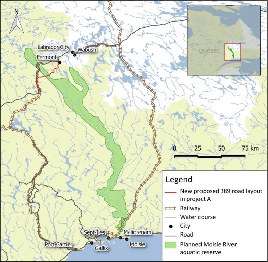
The Quebec Ministère des Transports, de la Mobilité durable et de l'Électrification des transports (the proponent or the MTMDET) is proposing the improvement of Route 389 between Fire Lake and Fermont to improve traffic flow and safety, enhance the link with Newfoundland and Labrador, and facilitate access to natural resources. The work includes 55.8 km of alignment on new rights-of-way and the upgrading of the existing road, for a total length of 68.9 km.
The project is part of the proponent's Route 389 Improvement Program, which covers approximately 200 km, divided into five separate projects:
- Project A: Major refurbishment and new road alignments (kilometres 478 to 564, between the Fire Lake mine and Fermont);
- Project B: Major refurbishment and new road alignment (kilometres 0 to 22, between Baie-Comeau and Manic-2);
- Project C: New road alignment (kilometres 240 to 254, north of Manic-5);
- Project D: Substandard curve corrections (kilometres 22 to 110, between Manic-2 and Manic-5); and
- Project E: Substandard curve corrections (kilometres 110 to 212, between Manic-3 and Manic-5).
This comprehensive study deals with Project A.
1.2 Purpose of the Comprehensive Study Report
This comprehensive study report summarizes the information and analyses that the Canadian Environmental Assessment Agency (the Agency) considered in determining whether the project may have significant adverse environmental effects as set out in the Canadian Environmental Assessment Act (S.C. 1992, c. 37) (the former Act), after taking into account the proposed mitigation measures.
The Minister of the Environment and Climate Change will consider this report and the comments from First Nations, the public, the proponent and government authorities, before making a decision on the significance of the adverse environmental effects and issuing a decision statement pursuant to the former Act. Before issuing the decision, the minister may request additional information or require additional measures to be taken. If the minister believes that the project is likely to have significant adverse environmental effects, she will refer to the Governor in Council the issue of whether those effects can be justified under the circumstances. Alternatively, if the minister issues a decision statement that the project is not likely to cause significant adverse environmental effects, Fisheries and Oceans Canada and Infrastructure Canada may decide to issue authorizations under section 37 of the former Act.
1.3 Scope of Environmental Assessment
The scope of the environmental assessment establishes the framework and limits of the Agency's analysis, including the regulatory and legislative requirements for an environmental assessment, the involvement of federal authorities in the environmental assessment, the factors considered, the selection of valued components, and the analysis methodology and approach.
1.3.1 Requirements of environmental assessment
The project is subject to comprehensive study under the former Act, which has been repealed and replaced, on July 6, 2012, by the Canadian Environmental Assessment Act, 2012 (CEAA 2012). The project is subject to a comprehensive study–type environmental assessment because it falls under paragraph 29(b) of the Comprehensive Study List Regulations, which reads as follows:
29 (b) The proposed construction of…an all-season public highway that will be more than 50 km in length and either will be located on a new right-of-way or will lead to a community that lacks all-season public highway access.
Under the transitional provisions of CEAA 2012, any comprehensive study of a Project commenced under the former Act before the day on which CEAA 2012 came into force must be continued and completed as if the former Act had not been repealed.
A federal environmental assessment is required because authorizations set out in the Law List Regulations may be issued by Fisheries and Oceans Canada under the Fisheries Act. Fisheries and Oceans Canada is therefore the responsible authority for this environmental assessment.
The former Act applies to federal authorities that contemplate certain actions or decisions that would enable a project to proceed in whole or in part. A federal environmental assessment is required because Fisheries and Oceans Canada will have to issue a Fisheries Act authorization in relation to the Project in accordance with paragraph 35(2)(b) of the Fisheries Act which allows the carrying on of any work, undertaking or activity that results in serious Footnote 2 harm to fish that are part of a commercial, recreational or Aboriginal fishery, or to fish that support such a fishery without contravening subsection 35(1) of the same act. The authorization is set out in the Law List Regulations. In addition, Infrastructure Canada may provide funding to the proponent under the New Building Canada Fund – Provincial-Territorial Infrastructure Component – National and Regional Projects for this project.
Because a comprehensive study type environmental assessment is required, the Agency is responsible for the environmental assessment until the comprehensive study report is provided to the Minister.
The project is not subject to an environmental review by the Government of Quebec under Division IV.1 of Quebec's Environment Quality Act.
1.3.2 Factors considered in the assessment
Pursuant to subsections 16(1) and 16(2) of the former Act, the Agency has considered the following factors:
- the purpose of the project;
- alternative means of carrying out the project that are technically and economically feasible and the environmental effects of any such alternative means;
- the environmental effects of the project, including the environmental effects of malfunctions or accidents, and any cumulative environmental effects that are likely to result from the project in combination with other projects or activities that have been or will be carried out;
- the significance of the environmental effects;
- the capacity of renewable resources that are likely to be significantly affected by the project to meet the needs of the present and those of the future;
- comments from the public that are received in accordance with the former Act and the regulations;
- measures that are technically and economically feasible and that would mitigate any significant adverse environmental effects of the project; and
- the need for, and the requirements of, any follow-up program in respect of the project.
An environmental effect, as defined in the former Act, is any change that the project may cause in the environment, including any change it may cause to a listed wildlife species, its critical habitat or the residences of individuals of that species, as those terms are defined in subsection 2(1) of the Species at Risk Act, any effect of any such changes on health and socio-economic conditions, the current use of lands and resources for traditional purposes by Aboriginal persons, or any structure, site or thing that is of historical, archaeological, paleontological or architectural significance, as well as any change to the project that may be caused by the environment.
1.3.3 Selection of valued components
The proponent's assessment of potential environmental effects focused on 21 natural and human environmental components that have a specific value or significance from a scientific, social, cultural, economic, historic, archeological or esthetic viewpoint, and on which the project is likely to have an effect.
The Agency grouped most of the environmental components into six valued components that were examined in the comprehensive study. The valued components and the rationale for their selection are shown in Table 1.
|
Valued component |
Rationale |
|---|---|
|
Atmospheric environment: Air quality, greenhouse gas emissions and sound environment |
Air quality is subject to legal protection at the provincial level under the Clean Air Regulation. Atmospheric emissions and changes to the sound environment (noise and vibrations) may affect users in the area and terrestrial, bird and aquatic wildlife. The greenhouse gas emissions contribute to climate change and have an impact on the environment. Nitrogen oxide and sulphur dioxide emissions contribute to acid rain, which also has an impact on the environment. |
|
Vegetation: Wetlands and special-status plant species |
Wetlands are important habitats for many species at risk, including the boreal caribou. Wetlands are used by First Nations for their current use of lands and as resources for traditional purposes. The project could result in the loss of rare and special-status plant species under the Species at Risk Act or Quebec's Act respecting threatened or vulnerable species. |
|
Fish and fish habitats: The water environment including surface water quality, aquatic and riparian vegetation, and fish species |
The project would result in changes to water quality and the water regime that could affect fish and fish habitats. Fish and fish habitats contribute to local fishing activities (including traditional fishing) and support ecological diversity. They are protected under the Fisheries Act. |
|
Birds and bird habitats: Water birds (including the waterfowl), land birds, birds of prey including special-status species and their habitat. |
The protection and conservation of migratory birds are governed by the Migratory Birds Convention Act, 1994. Certain species are protected under the Species at Risk Act or Quebec's Act respecting threatened or vulnerable species.. Some bird species are hunted by the users (including Firsts Nations) of the land. |
|
Terrestrial mammals and wildlife habitats: Fur-bearing animals, large wildlife, bats and their habitats |
The project would affect certain wildlife species listed in the Species at Risk Act, including woodland caribou. A number of terrestrial wildlife species are hunted by the users of the land. |
|
The current use of land and resources for traditional purposes and structures, sites or things of historical, archaeological, paleontological or architectural significance |
The project would have an impact on users of the land for traditional purposes, the resources they use and the activities they pursue, including hunting, fishing, trapping and gathering. In addition, the project could affect the accessibility and use of homes, trails and cultural and spiritual places. The project may also affect historic or archaeological sites of importance to First Nations. |
1.4 Methodology and Approach
1.4.1 Spatial boundaries
Spatial boundaries identify the geographic areas in which the potential effects of the project would likely occur.
The spatial boundaries defined by the proponent are considered appropriate by the Agency and have been used in assessing the potential environmental effects of the project. In general, the proponent has defined a study area 300 m wide on either side of the road alignment, for a corridor of 600 m, together with the area of the proposed borrow pits. The proponent considers this study area to be large enough to limit the environmental effects of the project on most of the valued components. The proponent has defined specific spatial boundaries for assessing certain environmental components because their functional area, or "ecosystem unit," extends beyond 600 m. The components include wetlands, air, birds of prey, fish and fish habitat, large wildlife, and the current use of lands and resources for traditional purposes. Appendix A shows the study area on which the impact analysis for each valued component was focused.
1.4.2 Temporal boundaries
Temporal boundaries have been set to account for all project activities that may adversely affect the environment. For the purposes of this environmental assessment, the temporal boundaries include the total life of the project, including the road construction and operation phases. No closures are expected since the proponent plans to maintain the road as it is operated.
The Agency has found that the temporal boundaries set by the proponent are appropriate for assessing the potential environmental effects of the project. The temporal boundaries for the assessment are as follows:
Construction: Four years following six months of deforestation and site preparation
Operation: Starts after construction and continues indefinitely.
1.4.3 Impact assessment
The Agency has reviewed the environmental impact statement, additional information from the proponent, comments from the public and First Nations, and opinions of federal and provincial experts. The Agency has also reviewed the potential environmental effects on the selected valued components and determined the significance of any residual adverse effects that may occur, taking into account the implementation of mitigation measures and a follow-up program. The mitigation measures that the proponent is committed to implementing are described in Appendix B.
The significance of environmental effects is determined on the basis of scientific data, Indigenous traditional knowledge, professional judgment and other factors. The Agency also relied on federal and provincial regulatory standards and guidelines (Appendix C). To decide on the significance of the residual effects, the Agency used the intensity, extent and duration criteria defined in Appendix D.
The matrix for determining the significance of environmental effects is presented in Appendix E. It characterizes the significance of effects in terms of three levels, namely high, medium and low. High-level environmental effects are considered significant by the Agency, while medium- and low-level effects are considered insignificant. Appendix F summarizes the valued components, the environmental effects and the Agency's conclusions on the significance of residual environmental effects. The directions of the follow-up program proposed by the proponent are presented in Chapter 9.
2 Project Overview
2.1 Project Location
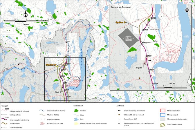
The Route 389 improvement project between Fire Lake and Fermont would be located in the administrative region of Nord-du-Québec, in the Caniapiscau Regional County Municipality. The northern section of the road would be located in the municipality of Fermont and the rest would be in the unorganized territory of Rivière-Mouchalagane (Figure 1). The geographical coordinates of the southern boundary would be 52°20′55″N, 67°24′33″W, and those of the northern boundary would be 52°49′33″N, 67°06′20″W.
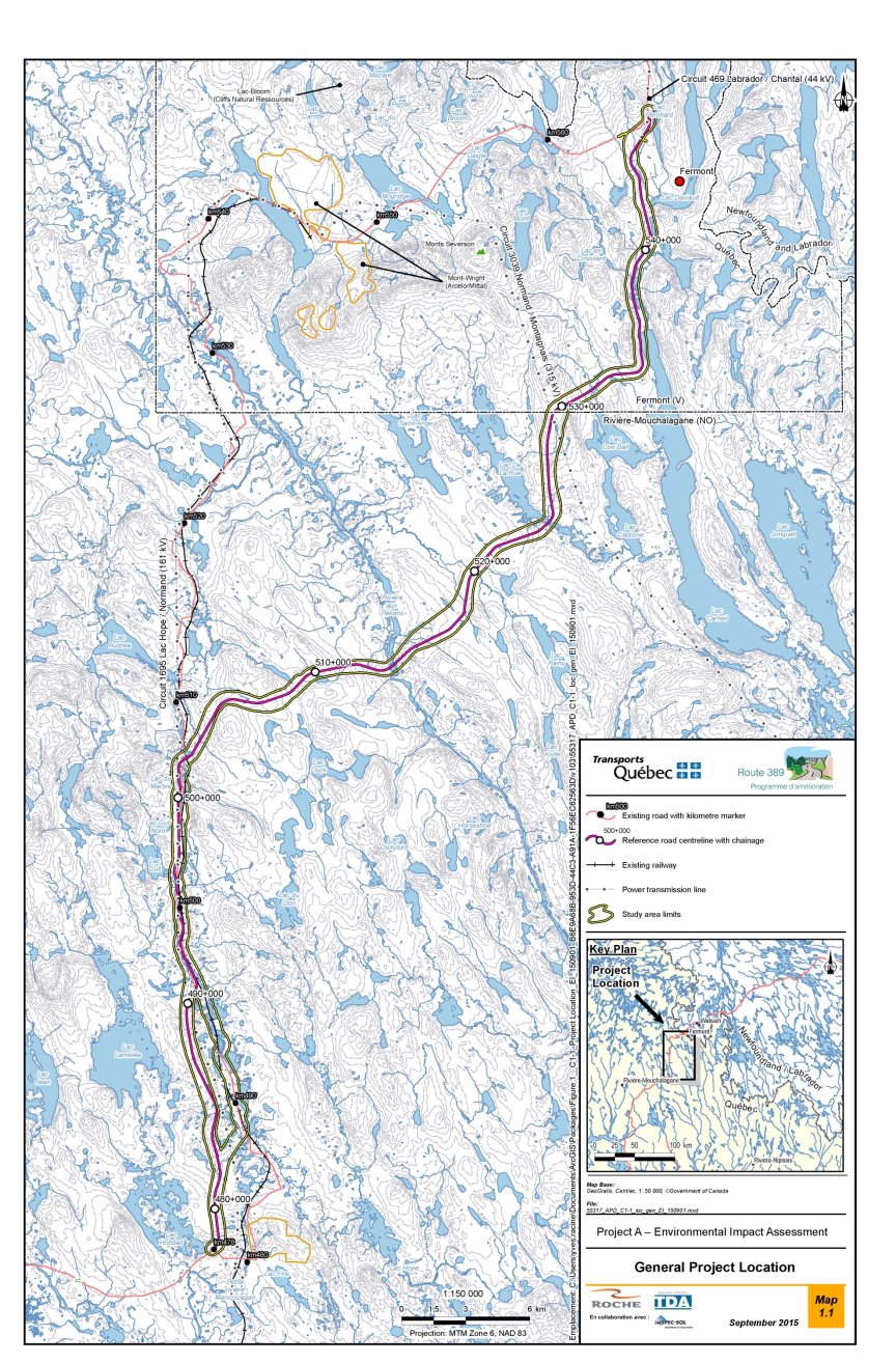
Source: MTMDET, 2015, page 5
2.2 Project Components
The project components are as follows:
- A low-volume road (fewer than 500 vehicles per day) with a total length of 68.9 km, including 55.8 km of alignment on new rights-of-way and the upgrading of the existing road. The road's features include the following:
- ? The road will be paved at the beginning and end of the alignment, kilometres 476 to 478.6 and kilometres 541.8 to 546.85. The middle portion of the road will be gravel.
- ? The width of the new rights-of-way will vary depending on the profile of the land and the road, but it is generally expected to be between 30 m and 35 m.
- ? The design speed is 90 km/h; however, some horizontal and vertical curves Footnote 3 could not be standardized for that speed because of technical or economic constraints.
- ? Slow lanes (approximately 13 km) and runaway lanes Footnote 4 (one every 10 km for a total of 8 km of runaway lane) are planned for purposes of traffic flow and safety.
- ? Side ditches and off-take ditches would be used to manage roadway runoff.
- Water crossings, namely 23 culverts and six bridges, with the largest structures being located on Lac De La Rue, Rivière aux Pékans and Petite rivière Manicouagan.
- Waste areas for excavated and non-reusable materials.
- Two temporary camps for 75 to 100 people.
Temporary facilities or infrastructure required for construction, such as coffer dams, access roads, work areas and storage areas.
2.3 Project Activities
The activities required to carry out the project are detailed in Table 2.
|
Phase |
Activities |
|---|---|
|
Construction (four years) |
|
|
Operation (indefinite period after construction): |
|
3 Purpose of and Need for the Project, Project Alternatives, and Alternative Means AnalysisFootnote 5
3.1 Purpose of and Need for the Project
The project is part of the Route 389 Improvement Program (the program) whose main objectives are to improve the safety and traffic flow of Route 389, enhance the link with Newfoundland and Labrador, and facilitate access to the region's natural resources.
Of the five projects in the program, this project is a priority because it serves Fermont, the second largest urban area of this program. The existing Route 389 has numerous deficiencies between kilometre 478 and the Mont-Wright mine (kilometre 547.75) in part because it was built in 1978 without following specific standards to access resources by various stakeholders (Hydro-Québec and forestry and mining companies).
The proponent's rationale for the project is based on a number of factors related to road safety, the development of mining and recreational tourism, and the wishes of the municipality and the community.
Road safety and non-compliance
Safety on the existing Route 389 is in question because the geometry and curves are non-compliant and many of the level crossings do not meet current MTMDET standards. The proponent states that 33% of the 76 accidents reported between January 2006 and December 2010 were attributable to poor road conditions and to improper alignment.
The roadbed has unclear and inconsistent lane and shoulder widths. A number of segments of the existing road lack ditches or have ditches that are too shallow. Furthermore, there are no "official" slow lanes or passing lanes.
A number of road segments have excessively steep slopes, which are a risk factor for heavy transport in particular. The proponent also states that over 90% of the 1,173 vertical curves and 94% of the 379 horizontal curves in the existing highway fail to meet visibility standards. Moreover, aside from the paved section, there are virtually no guardrails on the existing road.
The existing highway has 11 level crossings, 6 of which fail to meet current railway requirements in that the angle of intersection with the highway is unacceptable or the gradient at the approach to the crossings is too steep.
Development of mining
The economy of the study area is dominated by the resource sector, which includes the iron ore mining industry. The share of resource sector jobs is 48.3% in Fermont and 36.0% in Labrador City, well above the Quebec average of less than 4%.
Several mining companies are active in the areas of Fermont and Labrador West, including ArcelorMittal and Cliffs Natural Resources, Champion Iron Mines, and Rio Tinto Iron Ore.
The proponent also refers to mining development and exploration projects such as Fire Lake North by Champion Iron Mines. Other iron and graphite mines are being studied around Lac Knife and Lac Lamêlée by Focus Graphite, Nevada Resources Corporation, Fancamp Exploration Ltd. and Cliffs Naturals Resources, and Standard Graphite. In Labrador West, the main project is the Kami iron mine developed by Alderon Iron Ore Corp.
According to the promoter, although rail transport is the cornerstone for mining activities, road transport remains an important support and it seems crucial to support it with safe and sustainable infrastructure.
Development of recreational tourism
The construction of Route 389 on a new right-of-way would provide access to areas that are already used for recreation and tourism (for example vacationing, hunting, fishing, snowmobiling and quad biking) or that are identified by the Caniapiscau Regional County Municipality as being or potentially being used for recreation and tourism. Accordingly, Project A is seen as a tool for enhancing or developing recreational tourism activities in the Fermont area.
Wishes of the municipality and community
The proponent states that the relocation of Route 389 onto a new right-of-way has been advocated for decades in various forums by elected officials, businesses, workers' unions and Fermont residents. In its development plan, the Caniapiscau Regional County Municipality supports the replacement of the existing Route 389 with a new alignment. The proponent states that there is broad consensus in the community regarding the project.
3.2 Project Alternatives
Project alternatives are functionally different ways of meeting the need for the project and fulfilling the purpose of the project. The proponent has assessed Footnote 6 three alternatives, namely the status quo (Option 1), an upgrade of the existing Route 389 (Option 2) and a new highway (Option 3) (Figure 2).
The promoter performed a multicriteria analysis using three groups of criteria, namely safety, traffic flow, accessibility and maintenance with a weighting of 45%, natural and human environments with a weighting of 40%, and socioeconomic aspects with a weighting of 20%Footnote 7. To rank the various alternatives, the proponent used the 37 criteria in the table in Appendix H.
The proponent's analysis approach for selecting an alternative consists of the following steps:
- establish a scale from 1 to 5 for each criterion;
- determine a weighting for each criterion;
- measure each criterion;
- rank the result of each criterion on the scale;
- determine the weighted % result;
- sum the weighted results for each alternative; and
- compare the sum of the weighted results to choose an option.
A summary of the proponent's analysis is presented in the subsections that follow.
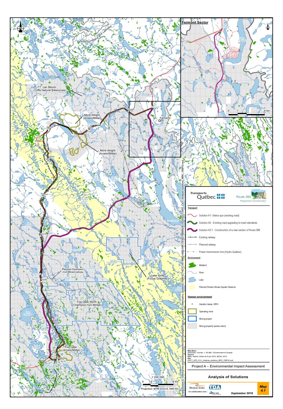
Source: MTMDET, 2015, p. 255.
3.2.1 Option 1: Status quo
Option 1 would be to keep the existing Route 389 as is between Fire Lake and Fermont, without correction or improvement. This option can be divided into three segments, from south to north:
- Segment 1 (kilometres 478 to 480—the Fire Lake mine area): paved road;
- Segment 2 (kilometres 480 to 547.75—between Fire Lake and Mont-Wright): approximately 67 km of gravel road with several technical deficiencies as described in 3.1; and
- Segment 3 (kilometres 547.75 to 566—between Mont-Wright and the Fermont area): approximately 18 km of paved road with fewer deficiencies than Segment 2.
This option would not involve any change in the alignment. The only work would be road maintenance and the gradual replacement of water crossings (for example culverts) when required. However, this solution would involve maintaining the defects and irregularities of the existing roadway that currently compromise user safety and hinder traffic flow.
This option would cause the least disruption to the natural environment since it would not involve enlargement work and that no new terrestrial natural environment would be disturbed.
Economically, Option 1 would have no construction cost, but would have higher maintenance costs, namely $3.56 million per year, compared with $2.71 million for Option 2 and $2.27 million for Option 3 (Appendix H).
3.2.2 Option 2: Upgrade of the existing Route 389
Option 2 would be to correct and improve the current road alignment and profile to meet the standards of a national highway with a posted speed of 90 km/h, however certain sections would be limited to 70 km/h for technical and economic reasons. This option would result in a projected highway of 82 km, 5 km shorter than the existing highway. The segments are the same as in Option 1, and the work would be as follows:
- Segment 1: refurbishment of the existing paved section according to current standards;
- Segment 2: upgrade to roadway standards involving a near-complete reconstruction of the existing roadway, including the replacement of culverts, improved drainage and the construction of a new pavement structure; and
- Segment 3: refurbishment of the existing paved section according to current standards and the correction of substandard curves.
This option would achieve the project objectives defined in Section 3.1 (purpose of the project). However, the proponent believes that certain areas of the road could not be totally compliant with current MTMDET standards for technical, environmental impact or economic impact reasons. The road would now have five grade crossings, of which three are new for solution 2 compared to 11 level crossings for option 1.
The proponent believes that option 2 would have less impact on the natural environment compare to option 3 since it would salvage a greater part of the existing highway. However, some terrestrial habitats, wetlands and aquatic environments near the existing highway could be affected by the refurbishment of sections, bridge and culvert modifications or refurbishment and by its widening of the highway. The proponent states that a 23.5 km stretch of the existing highway is within 60 m of a body of water. Option 2 could affect the natural habitats on a stretch of 31 km and a cumulative 0.9 linear km of wetlands.
Economically, the proponent estimates the construction cost and maintenance cost for Option 2 at $181 million and $2.71 million, respectively. Those costs would be higher than those for Option 3, at $169 million and $2.27 million, respectively (Appendix H).
With respect to social acceptability, the proponent states that Option 2 does not avoid the busier area of the Mont-Wright mine. As well, the savings in time and money would be less for users since the road would be 18 km longer.
3.2.3 Option 3: New highway
Option 3 would be the construction of an entirely new highway between Fire Lake and Fermont, in addition to a major upgrade of part of the existing alignment. The total length of the proposed highway would be 68.9 km. As a result of this solution, the existing alignment between the Fire Lake mine and the Mont-Wright mine would be abandoned. In this case, the work is divided into three new segments as follows, from south to north:
- Segment 1: Between kilometres 478 and 491, the proposed Route 389 would branch north onto a new right-of-way to meet the existing road at approximately kilometre 497. The length of Segment 1 would be approximately 13 km.
- Segment 2: Between kilometres 491 and 502, the proposed Route 389 essentially follows the path of the existing road. The length of Segment 2 would be approximately 11 km.
- Segment 3: Between kilometres 502 and 546, the proposed Route 389 would branch northeast onto a new right-of-way, cross the Rivière aux Pékans and Lac De La Rue, bypass Lac Low Ball to the north, then follow an existing road linking Lac Carheil to Fermont, before bypassing Fermont to the west and rejoining Route 389. A new road link with Fermont is planned, connecting the proposed Route 389 with the existing Duchesneau Street. The length of Segment 3 would be approximately 45 km.
The proponent considers options 3 and 2 to be similar for most of the criteria related to safety, traffic flow and maintenance. Option 3 would, however, reduce the number of level crossings from 11 (currently) to 3. It would also have more guardrails to reduce the impact on vehicles and their occupants if the vehicle accidentally runs off the road (Appendix H).
Environmentally speaking, the proponent states that Option 3 is designed to avoid sensitive areas such as aquatic environments and wetlands as much as possible. However, this option would cut across an undisturbed area, thereby fragmenting the habitat of terrestrial wildlife, particularly boreal caribou.
In terms of social acceptability, a survey conducted by the proponent at an open house in Fermont shows that almost all the respondents are in favour of a new highway for the following main reasons: time and money savings resulting from the new route being approximately 18 km shorter than the existing route, a smaller number of railway crossings and the new section's straight alignment, which will provide many opportunities for passing heavy vehicles.
The proponent noted that Indigenous and non-Indigenous participants also referred to the hunting and fishing access that Option 3 would provide. The proponent believes that recreational activities related to wildlife and nature are an important aspect of the quality of life in northern communities and are a major part of the life of the people of Fermont. The proponent states that the new highway would make it easier for non-Indigenous people to use and access the land and would enable the development of recreational tourism and industry. However, this option would have a greater impact on the current use of land and resources by Innu First Nations people.
Economically, Option 3 has lower construction and maintenance costs than Option 2, as noted above.
3.2.4 Choosing an option
The table in Appendix I summarizes the proponent's assessment of project alternatives by ranking them according to safety, traffic flow, accessibility and maintenance, and respect for the natural and socioeconomic environment.
The results of the analysis show that Option 3, with an overall score of 77.8%, is better than Option 2, with 65.6%, and Option 1, with 51% (Table 3 and Appendix I).
According to the proponent's analysis, although Option 1 is the most economical, it is the lowest ranked because it does not meet one of the main objectives of the project, namely to make the highway safer. The promoter has chosen Option 3, which is ranked higher overall than Option 2. Although their results are comparable in terms of technical criteria (36.4% versus 37.6%), Option 3 would have a clear advantage in terms of socioeconomic aspects (15.5% versus 8.4%) (Appendix I).
|
Criteria (weighting) |
Option 1 (Status quo) |
Option 2 (Upgrade of the existing highway) |
Option 3 (New highway) |
|---|---|---|---|
|
Safety, traffic flow, accessibility and maintenance (45%) |
3 |
2 |
1 |
|
Natural and human environments (40%) |
2 |
3 |
1 |
|
Economics |
1 |
3 |
2 |
|
Total (105%) |
3 |
2 |
1 |
3.3 Alternative Means Assessment
Under the former Act, it is also required to examine alternative means of carrying out the project that technically and economically feasible and to examine the environmental effects of those alternative means.
The alignment variants A, B, C and D identified for the analysis are variations in the layout and profile of the chosen option, generally over a single length of less than 10 km. The proponent has compared the variants with the chosen option (Section 3.2.4) based on the technical, environmental and economic criteria in Table 4.
|
Aspect |
Criteria |
|---|---|
|
Technical |
|
|
Environmental |
|
|
Economic |
|
Having completed the analysis, the proponent has decided not to adopt any of those variants but rather to optimize the chosen option. The proponent believes that the chosen option would result in significant gains in terms of road safety, traffic control and management during construction, and the environment.
Detailed variant analysis results can be found in Appendix J, and the following subsections summarize the advantages and disadvantages of the four alignment variants analyzed by the proponent in comparison with the chosen option.
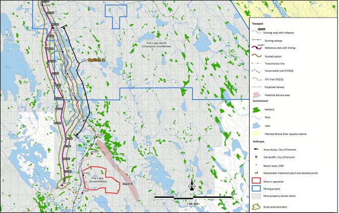
3.3.1 Variant A
Variant A starts approximately 4 km north of kilometre 478 of the existing highway and lies between kilometres 481.7 and 491.3 of the chosen option (Figure 3). Starting at kilometre 481.7, this variant would branch northeast to meet the existing road shortly after kilometre 489. The alignment would generally follow the existing highway, except for an additional curve shortly before kilometre 490.
Variant A has the following advantages over the chosen option:
- two non-compliant 100 km/h vertical curves versus four;
- significantly less excavated material;
- terrestrial habitat losses of 26.65 ha versus 42.38 ha; and
- wetland losses of 0.36 ha versus 0.93 ha.
However, Variant A has the following disadvantages:
- total length of 10.18 km, 580 m longer than the chosen option;
- two level crossings, whereas the chosen option would not have any;
- 10 horizontal curves that fail to meet MTMDET standards for a design speed of 100 km/h, whereas the chosen option would have none;
- opportunities for passing along 0.8 km versus 3.7 km;
- four water crossings versus three;
- encroachment into 15 280 m² of fish habitats versus 210 m²; and
- more difficult traffic control during construction.
The proponent states that Variant A would be similar to the chosen option in terms of construction costs and the impact on Hydro-Québec's power lines, which would be encountered once.

Source: provided by MTMDET
3.3.2 Variant B
Variant B lies between kilometres 498.6 and 502.6 of the chosen option, but instead of continuing north onto new rights-of-way, this variant would run along the existing Route 389 (Figure 4).
Variant B, which is similar in length to the chosen option (3.96 km versus 4.02 km), has a few advantages, including fewer non-compliant curves (two versus three), a smaller loss of terrestrial habitats (9.56 ha versus 18.56 ha) and a 50% smaller volume of excavated material.
However, Variant B would have a number of disadvantages compared with the chosen option:
- location closer to the railway;
- more encroachments into lakes (2 300 m² versus 660 m²);
- more filling of wetlands (0.53 ha versus 0.20 ha);
- 10% higher construction costs; and
- more difficult traffic control during construction.
Source: provided by MTMDET
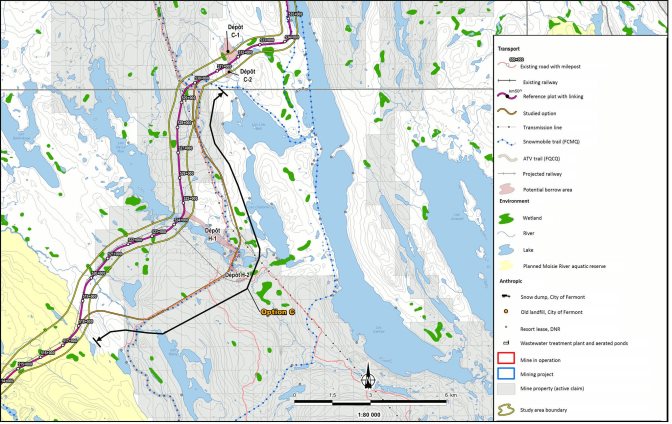
3.3.3 Variant C
Variant C lies between kilometres 517.3 and 530.65 of the chosen option (at the northern end of Lac Low Ball) (Figure 5).
The analysis shows that Variant C is similar to the chosen option in terms of lost wetlands (0.96 ha versus 1.08 ha) and terrestrial habitats.
Variant C, which is 15.9 km long, has a few advantages over the chosen option:
- no non-compliant curves; and
- fewer water crossing structures (four versus six).
However, Variant C has the following disadvantages:
- a length that is 2.57 km greater;
- a greater loss of fish habitats (730 m² versus 470 m²); and
- 15 % higher construction costs.
Variant C would cross Lac De La Rue about 3 km southeast of the chosen option, where it is narrower, which would mean building a less expensive bridge. However, as Variant C is 2.57 km longer, its overall construction cost would be higher.
Source: provided by MTMDET
3.3.4 Variant D
Variant D is located at the junction with the existing Route 389 at the northern boundary of the project, between kilometres 543.6 and 546.9, to the north of the chosen option (Figure 6).
Variant D and the chosen option are similar in length (3.14 km versus 3.04 km) and in terms of encroachment into fish habitats (140 m²).
Variant D has no encroachment into wetlands, compared with 0.31 ha for the chosen option. However, it would have a number of disadvantages:
- reduced safety in the approaches to the Claude Ménard Boulevard intersection;
- slightly greater loss of terrestrial habitats (11.72 ha versus 11.23 ha);
- 14% higher construction costs; and
- the relocation of a number of Hydro-Québec transmission line towers.
Source: provided by MTMDET
3.4 Comments Received
Federal authorities
The Agency has not received comments from federal authorities regarding the purpose of the project, project alternatives and alternative means analysis.
Public
The Agency has not received comments from the public regarding the purpose of the project, project alternatives and alternative means analysis.
First Nations
The Innu First Nation of Uashat mak Mani-Utenam raised concerns about the lack of real consultation by the proponent regarding the chosen option of building a highway on new rights-of-way that would open up the area and divide their claimed ancestral land (Nitassinan).
As for the alternative means analysis, the Innu First Nation of Uashat mak Mani-Utenam believes that choosing Variant A would have made it possible to use the rights-of-way of the existing highway and choosing Variant C would have avoided cutting through Lac De La Rue.
The proponent states that it consulted with First Nations as part of the project and that the chosen option is the most advantageous based on 37 criteria, including the impacts of the project on First Nations.
3.5 Agency's Analysis and Conclusion
The Agency is satisfied that the proponent has sufficiently assessed alternative means of carrying out the project for the purposes of assessing the environmental effects of the project under the former Act.
The proponent has provided the requested information, presenting alternatives to the project and discussing the environmental, technical and economic advantages and disadvantages of each option. In addition, the proponent has explained the approach used to rank the project alternatives and arrive at the chosen option, namely constructing the highway on new rights-of-way.
The proponent then analyzed four alignment variants on different sections of the chosen option. The Agency considers the proponent's criteria and variant analysis to be adequate.
4 Consultation Activities and Advice Received
Public and First Nations consultations enhance the quality and credibility of environmental assessments. The comments and concerns received through consultations help to clarify the potential effects of a project, beginning at the planning stage. As part of the Route 389 improvement project between Fire Lake and Fermont, the Agency, in co-operation with the federal environmental assessment committee, conducted a number of consultations with the public and First Nations.
4.1 Consultation with First Nations
4.1.1 Agency's consultation with First Nations
The federal government has a duty to consult and, where appropriate, accommodate Indigenous people when considering decisions that may adversely affect established or potential Indigenous or treaty rights. Indigenous consultation is also undertaken more broadly as an important part of good governance, policy development, and informed decision making. In addition, the former Act requires that all federal environmental assessments take into account the effects of the project either on the current use of lands and resources for traditional purposes by Indigenous peoples, or on a structure, site or thing of historical, archaeological, paleontological or architectural significance.
For the purposes of this environmental assessment, the Agency coordinated federal Crown consultations and consulted the Innu First Nation of Matimekush–Lac John, the Innu Nation (Labrador), and the Innu First Nation of Uashat mak Mani-Utenam Footnote 8. For good governance purposes, the Agency also informed Innu First Nation of Pessamit of the major steps in the environmental assessment.
The Agency did not have a consultation plan with Innu Nation as the Innu of Labrador are relatively far from the study area and did not provide any comments on the adverse effects that the project might have on their claimed rights. However, the Agency kept the First Nation informed of the major stages of the environmental assessment.
The Agency agreed with the Council of Innu First Nations of Matimekush–Lac John and of Uashat mak Mani-Utenam on consultation plans that included participation in various stages of the environmental assessment. By the end of the comprehensive study process, the First Nations will have had three formal opportunities for consultation.
The Agency supports First Nations participation through the Participant Funding Program. As part of the comprehensive study, the Agency allocated a total of $114,528 to the two First Nations that applied for funding, namely the Innu First Nations of Matimekush–Lac John and Uashat mak Mani-Utenam.
Throughout the environmental assessment process, the Agency has maintained regular contact with First Nations. To announce the three consultation opportunities, the Agency notified the relevant band councils in correspondence and placed notices in the newspaper Innuvelle.
During the first consultation opportunity (May 24 to June 26, 2012), for comments on the draft guidelines for the proponent, the Agency received comments from the Innu First Nation of Uashat mak Mani-Utenam, specifically on the consultation approach of the Agency and the proponent.
During the second consultation period (January 25 to February 24, 2016), on the summary of the environmental impact statement, First Nations were invited to comment on the environmental effects of the project, the impacts on claimed or treaty rights, and the accuracy of the information provided by the proponent in the environmental impact statement. The Agency held a meeting with the councils of the Innu Nations of Matimekush–Lac John (February 25, 2016) and Uashat mak Mani-Utenam (June 15, 2016). The Agency and representatives of the Federal Environmental Assessment Committee also met with members of the community and of the Grégoire family in Sept-Îles on June 15, 2016. These meetings enabled First Nations members to discuss their various concerns regarding the project with representatives of the Agency and the federal environmental assessment committee. Comments received at these meetings helped guide the Agency's review of the environmental impact statement and highlighted the need for additional information from the proponent to better assess the effects of the project.
During the second consultation period, the Innu First Nations of Uashat mak Mani-Utenam and Matimekush–Lac John submitted briefs to the Agency describing the use of the land and the potential impacts of the project on that use. The issues raised include the maintenance of traditional activities, access to their traditional territory and its availability to non-Indigenous people, the preservation of the Innu archaeological and cultural heritage, the effects on the sacred Moisie River, the economic opportunities related to the project and the effects on wildlife, particularly woodland caribou.
For the third consultation period, the Agency is inviting First Nations to provide comments on the content, conclusions and recommendations of this comprehensive study report. The Agency will present the comments received to the Minister of Environment and Climate Change to inform a decision on the environmental assessment of this project.
The effects of the project on the current use of lands and resources by First Nations are discussed in Section 6.6, and the implications for established or potential Indigenous and treaty rights are discussed in Chapter 8. Appendix F summarizes the concerns raised by First Nations during the environmental assessment process and includes the responses of the proponent and the Agency. Subsequent comments from First Nations will be provided to the Minister of Environment and Climate Change to inform her decision on the environmental assessment.
Following the Minister's decision on the environmental assessment, Fisheries and Oceans Canada, as the responsible authority for the project, may consult the affected First Nations regarding authorizations to be issued under the Fisheries Act for the implementation of the project, including fish habitat compensation projects.
The Agency will submit comments received to the Minister of Environment and Climate Change Canada to inform its decision regarding the environmental assessment of this project. If the environmental assessment decision is favorable, Fisheries and Oceans Canada could issue an authorization or authorizations under paragraph 35 (2) (b) of the Fisheries Act for the project. If this is the case, a specific consultation process will be initiated by Fisheries and Oceans Canada.
4.1.2 Proponent's consultation with First Nations
The proponent consulted the Innu First Nations of Uashat mak Mani-Utenam and Matimekush–Lac John and Pessamit in preparing the environmental impact statement and the environmental assessment for the project.
In particular, the proponent met with the Uashat mak Mani-Utenam and Pessamit band councils in 2013 and organized an "open house" in the Uashat mak Mani-Utenam community in May 2014, in addition to meeting in 2016 with the main users of the land who might be affected by the project. The proponent also consulted with the Innu Nation of Matimekush–Lac John, meeting with the band council and organizing a town hall meeting in February 2017. The issues raised at the meetings held by the proponent were similar to those raised during the Agency's consultations.
Note that the proponent attended meetings arranged by the Agency on June 15, 2016, with the Uashat mak Mani-Utenam First Nation and the community.
4.2 Public Consultation
4.2.1 Agency's public consultation
The environmental assessment process completed under the former Act provides for three periods of public participation, namely during the preparation of the environmental impact statement guidelines, the environmental impact statement analysis and the release of the comprehensive study report.
To announce the first two stages of public participation, the Agency posted notices on the Canadian Environmental Assessment Registry website and in various newspapers, and placed radio spots on local stations. Documents relevant to the consultations were added to the Canadian Environmental Assessment Registry website and hard copies were made available at various public places in communities near the project.
The first consultation, held by the Agency from May 24 to June 26, 2012, was to obtain comments on the draft guidelines for the proponent. During this initial consultation, the Agency did not receive any comments from the public.
The second consultation, from January 25 to February 24, 2016, was an opportunity for those interested to comment on the potential environmental effects of the project and the mitigation measures proposed by the proponent in its environmental impact statement. During this second consultation, the Agency did not receive any comments from the public.
For the third consultation period, the Agency is inviting the public to comment on the content, conclusions and recommendations of this comprehensive study report. The Agency will submit this report to the Minister of Environment and Climate Change to inform her decision regarding the environmental assessment of this project.
4.2.2 Proponent's public participation activities
Starting in 2011, the proponent undertook information and consultation activities primarily targeting elected officials of the regional county municipalities of Caniapiscau and Manicouagan, environmental organizations, the general public, and the Innu First Nations of Matimekush–Lac John, Pessamit and Uashat mak Mani-Utenam. The proponent states that the purpose of the meetings was to outline the Route 389 improvement program and the aspects associated with the various projects (for example construction work, schedules and budgets), to establish a collaborative relationship with stakeholders and determine the means of communicating with them, and to hear the attendees' questions, comments and concerns.
Among other things, the proponent held open houses between September 2013 and May 2014 in Baie-Comeau, Fermont, Pessamit and Sept-Îles. The purpose of the open houses was to establish more direct contact with the public, to compile the public's general comments and concerns about the projects, and to find out the public's preferred alternatives. A total of 162 people attended the open houses. The proponent states that the days made it possible to confirm the public's support for the Route 389 improvement program and the participants' agreement on the choices made. Some participants allegedly expressed concern that the timelines were too long.
4.3 Participation of Federal Government and Other Experts
Federal government departments provided expert information or knowledge relevant to the project in accordance with subsection 12(3) of the former Act.
The following federal authorities provided opinions related to the guidelines, the review of the proponent's environmental impact statement and the preparation of this comprehensive study report: Fisheries and Oceans Canada, Infrastructure Canada, Environment and Climate Change Canada, and Health Canada. Some of these federal authorities also helped with planning and conducting consultations with First Nations throughout the federal environmental assessment process.
Fisheries and Oceans Canada, which has regulatory and legal responsibilities under the Fisheries Act, provided comments and information on potential adverse effects of the project on fish and fish habitats. As part of the environmental assessment, Fisheries and Oceans Canada has stated that the proponent would require an authorization or authorizations under the Fisheries Act to carry out the project.
Infrastructure Canada may provide funding to the proponent under the New Building Canada Fund – Provincial-Territorial Infrastructure Component – National and Regional Projects for this project.
Environment and Climate Change Canada has regulatory and legal responsibilities under the Canadian Environmental Protection Act, 1999, the Migratory Birds Convention Act, 1994, the Species at Risk Act and the pollution prevention provisions of the Fisheries Act. Environment and Climate Change Canada has provided comments and information on potential adverse effects of the project on migratory birds and bird habitats, species at risk, water quality, air quality, chemicals management, and environmental emergencies.
Health Canada has provided comments and information on potential adverse effects on human health that may result from changes in air and water quality, in the sound environment, and from the contamination of traditional food.
The Agency also worked with provincial experts from the Quebec Ministère de la faune et des parcs (MFFP) and the Ministère du Développement durable, de l'Environnement et des Changements climatiques (MDDELCC) which have provided advice on special-status species, namely boreal caribou and brown-edged pussytoes.
5 Geographical Setting
5.1 Biophysical Environment
The project would be located in the Canadian Shield, specifically in the northern part of the geologic province of Grenville. The study area covers the Fermont Iron Ore District, which is located in a major geological belt called the Labrador Trough and which is known for its significant iron ore reserves.
The surface of the soil is characterized by deposits resulting from the retreat of the Laurentide Ice Sheet during the last glaciation. Otherwise, the soil is mainly Precambrian-age metamorphic and igneous rocks. These are not very permeable, but significant fracture zones are present in the region and could potentially serve as preferential corridors for groundwater flow.
The area is part of the high lake plateau of Côte-Nord. The project would cross three watersheds, namely Petite rivière Manicouagan, Rivière aux Pékans and Lac Carheil. The topography is rather flat and there are numerous lakes, some large, such as Lac Carheil and Lac De La Rue. The area is crossed by several watercourses that are part of the large watershed of the Moisie River. The Government of Quebec plans to create an aquatic reserve on the Moisie River that will be subject to "strict protection"Footnote 9 to preserve its biodiversity while allowing recreational access to the public. For now, this reserve has temporary protection until 2025, which prevent mining and industrial exploitation. The project would cross this reserve over a distance of approximately 11 km (Figure 7). The proponent has sampled various watercourses that the project will cross and states that the physical and chemical quality of the water observed (pH, conductivity, turbidity, temperature and dissolved oxygen) varies greatly.Footnote 10
The region is dominated by a cold, moderately wet subpolar climate with a relatively short growing season. The average annual temperature hovers around −3.9°C. Winters are long, cold and dry, while summers are short.
The vegetation in the study area is 67% dominated by the eastern subdomain of the spruce-moss forest and 33% covered by the domain of the spruce-lichen forest. Black spruce (Picea mariana) is predominant and is occasionally accompanied by balsam fir (Abies balsamea) and tamarack (Larix laricina).
Of the wetlands present, peatlands are the most abundant: 94% of wetlands are peatlands, 5.5% are swamps and 0.4% are marshes. The peatlands cover 4.3% of the study area and are found mainly at the bottom of valleys and along watercourses.
The data sent to the proponent by the Centre de données sur le patrimoine naturel du Québec have revealed that references have been made to plants in the study area that are likely to be designated as threatened or vulnerable. The brown-edged pussytoes (Antennaria rosea subsp. confinis) is the only special-status vascular species reported by the Centre de données sur le patrimoine naturel du Québec that was observed in 2001 on either side of Route 38 at 60 km south of Fermont.
With regard to wildlife, the presence of 4 species of amphibians, 12 species of fish, 21 species of mammals and 54 species of birds was confirmed on the site during the inventory conducted by the proponent. The ranges of the little brown myotis and the northern myotis, designated "endangered" under the Species at Risk Act, cover the study area. The proponent did not conduct an inventory of bats. However, an assessment of the potential for presence during the breeding, migration and overwintering periods was conducted using the information available on these species and on the habitats present in the study area.
None of the species of amphibians or fish which were observed in the study area have special status at the federal or provincial level (COSEWIC, 2013). Of the mammals for which sightings were confirmed, the rock vole and Cooper's lemming vole are likely to be designated as threatened or vulnerable on the MDDELCC's list of species likely to be designated as threatened or vulnerable. Boreal caribou, present in the area, are considered threatened in Canada under the Species at Risk Act and vulnerable in Quebec under the Act respecting threatened or vulnerable species. The wolverine has a special concern status in Canada (Species at Risk Act) and the pygmy weasel is a vulnerable species in Quebec. These two species were not observed in the study area.
Of the bird species at risk listed in Schedule 1 of the Species at Risk Act and potentially present in the study area, the olive-sided flycatcher, bank swallow, rusty blackbird and common nighthawk have been confirmed. However, the presence of the anatum subspecies of peregrine falcon, harlequin duck, barn swallows and short-eared owl was not confirmed during the inventories. Finally, the presence of the bald eagle, designated as "vulnerable" under the Act respecting threatened or vulnerable species, was observed in the study area but its nesting has not been confirmed.
5.2 Human Environment
The main demographic and economic characteristics of the study area correspond to those of Fermont, the unorganized territory of Rivière-Mouchalagane and the Caniapiscau Regional County Municipality in Quebec, and Labrador City, Wabush and Economic Zone 2 in Newfoundland and Labrador. In Statistics Canada's 2016 Census, the populations of Fermont, Labrador City and Wabush were 2,288, 8,622 and 1,906, respectively.
According to the proponent, the economy of the study area is dominated by the resource sector. According to the proponent, the participation and employment rates in Fermont and Labrador City are exceptionally high. However, the proponent states that the region's vitality is vulnerable to market fluctuations because the economy, which is based on mining, is not very diversified. Fermont is therefore seeking to diversify its economic activity through the development of new minerals, mining tourist attractions and outdoor activities.
With regard to trapping, the study area is located in the Saguenay beaver reserve, and the Innu First Nation of Uashat mak Mani-Utenam has special but not exclusive rights in the Sept-Îles division. The project passes through trapping lots of the Innu families of this First Nation, such as the Grégoire family's Lot 255. The project is located on land that is the subject of comprehensive land claim negotiations by the Innu Nations of Uashat mak Mani-Utenam and Matimekush–Lac John.
Uashat mak Mani-Utenam First Nation has 3,728 members registered as residents on the reserve. The First Nation's economy is based on the public sector. The band council, with nearly 267 permanent jobs and 600 seasonal jobs, is the main employer of the Innu of this nation and one of the largest in the Sept-Îles region.Footnote 11 According to the information collected on the website of the Nation, the Uashat and Mani-Utenam reserves have approximately 50 companies specializing in various fields such as food service, commercial fishing and seafood processing, tailoring, canoe manufacturing, campground development and management, landscaping, heavy machinery, electricity, management services, and translation.Footnote 12
The Innu First Nation of Matimekush–Lac John, which has 829 members registered as residents on the reserve,Footnote 13 is approximately 700 km north of the project study area. Information gathered during the proponent's various consultations with this First Nation confirmed that the selected road alignment crosses the main traditional Innu transportation route between Rivière aux Pékans and Wabush Lake.
6 Predicted Effects on Valued Components
6.1 Atmospheric Environment
This section presents the analysis of the project's effects on the atmospheric environment (air quality, greenhouse gas (GHG) emissions and ambient noise).
According to the Agency, a significant residual adverse effect on the atmospheric environment is one that would cause a high risk of exposure to air contaminants that exceed applicable standards and criteria of health protection, or an increase of noise that exceed standards or criteria of health protection, and that people are exposed to it regularly or continuously Footnote 14. For greenhouse gas emissions, only the significance of the contribution of the project is assessed. The Agency's criteria for evaluating environmental effects and the grid used to determine the significance of the effects are presented in Appendices D and E, respectively.
Based on its analysis, the Agency concludes that the project is unlikely to result in significant adverse environmental effects on the atmospheric environment, given the mitigation measures and monitoring and follow-up programs proposed by the proponent:
- The population, including First Nations, would be little exposed to the contaminants emitted by the project. The project area is not heavily developed. Increased levels of dust, metals, metalloids and other contaminants in the air are unlikely to exceed health protection standards and criteria if mitigation measures are applied properly.
- The quantity of greenhouse gas emissions generated by the project would not contribute significantly to greenhouse gas emissions at the provincial and national scale.
- It is unlikely that noise increases will exceed the standards and criteria for health protection.
- Greenhouse gas emissions estimated at 7,295 tonnes of carbon dioxide equivalent (CO2 eq) per year for the construction phase and 2,649 tonnes of CO2 eq per year in operation would not be a high contribution to provincial and national emissions.
The following subsections describe the baseline conditions and the essential elements of the proponent's analysis, present the opinions of the expert departments, the First Nations and the general public, on which the Agency based its conclusion regarding the significance of the project's effects on the atmospheric environment.
6.1.1 Baseline conditions
The proponent used the general study area to characterize air quality and noise levels. Greenhouse gas emissions were examined in a broader context, since the effects of these gases on the environment are a concern at the provincial, national and global levels.
Air quality and emissions of contaminants
To characterize air quality, the proponent used data from the National Air Pollution Surveillance Network and the National Pollutant Release Inventory. The National Air Pollution Surveillance Network is a Canada-wide network of ambient air quality sampling stations.
In order to provide a more representative picture of air quality in the study area, the proponent compiled the results from the closer stations: Chapais, Pémonca and Labrador City (Smokey Mountain). None of those stations are located directly in the study area and none has sufficient data to be able to draw an adequate portrait of the study area. For example, at the Chapais sampling station, only ozone concentration are measured; at the Pémonca station, concentrations of ozone and fine particulate matter (PM2.5) are measured. At the Labrador City station, concentrations of sulphur dioxide (SO2), nitrogen dioxide (NO2), ozone and fine particulate matter (PM2.5) are measured but only data from 2014 are available.
For ozone concentrations, the data from the Chapais and Pémonca stations were compared with the standards in the Québec Regulation for the Cleaner Atmosphere (Q-2, r 4.1) and the Canadian Ambient Air Quality Standards. Thus, for Quebec standards, the one-hour maximum concentrations are occasionally exceeded and exceedances of the standard eight-hour are observed each year, but the national objective is met.
At the level of fine particles (PM2.5), the proponent compared the data from the Pémonca station with the applicable Quebec standard. Thus, for the data of the station of Pémonca, the norm in force has always been respected.
At the Labrador City station, results indicate that contaminant concentrations (SO2, NO2 and PM2.5) are below provincial and federal standards. Only ozone concentrations occasionally exceeded provincial standards (Table 5).
|
Contaminants |
Period |
Maximum value obtained (µg/m3) |
Applicable standard (µg/m3) |
Frequency of exceedance (%) |
|---|---|---|---|---|
|
Source: MTMDET, 2016, page 124. |
||||
|
Sulphur dioxide (SO2) |
4 minutes |
127.1 |
1,050 |
0.00 % |
|
24 hours |
10.8 |
288 |
0.00 % |
|
|
Annual |
1.51 |
52 |
0.00 % |
|
|
Nitrogen dioxide (NO2) |
1 hour |
89.1 |
414 |
0.00 % |
|
24 hours |
24.6 |
207 |
0.00 % |
|
|
Annual |
0.62 |
103 |
0.00 % |
|
|
Fine particulate matter (PM2.5) |
24 hours |
14 |
30 |
0.00 % |
|
Annual |
2.46 |
10 |
0.00 % |
|
|
Ozone (O3) |
1 hour |
194.5 |
160 |
0.09 % |
|
8 hours |
175.5 |
125 |
0.16 % |
|
According to the National Pollutant Release Inventory,Footnote 15 there are no large industrial emitters in the study area. The only emitter in the area which appears on the Inventory is the ArcelorMittal mine at Mont Wright. However, the route of the new road is not adjacent to the ArcelorMittal mine.
Some other mines are in the vicinity of the study area but have insufficient emissions to be included in the National Pollutant Release Inventory. However, they are sources of emissions of air contaminants. These mines include:
- The Fire Lake mine, owned by ArcelorMittal, approximately three kilometres east of existing Highway 389;
- Cliffs Natural Resources' Lake Bloom Mine near the current route of Route 389 near Fermont;
- Cliffs Natural Resources' Scully Mine, located in Labrador 17 km northeast of Fermont;
- Labrador's Carol Lake Mine, owned by Rio Tinto IOC, located 29 km north-northeast of Fermont.
Several mining projects are also under development in the study area. Emissions of air contaminants could therefore possibly come from the operations of these mines.
Greenhouse gases
Greenhouse gases are atmospheric gases that absorb and reflect infrared rays, causing warming of lower levels of the atmosphere. They are recognized as one of the causes of climate change, which can have various impacts on ecosystems and human health. The major greenhouse gases include carbon dioxide (CO2), methane (CH4), nitrous oxide (N2O), sulphur hexafluoride (SF6), ozone (O3), hydrofluorocarbons (HFCs) and perfluorocarbons (PFCs). Estimates of greenhouse gases are normally expressed in tonnes of carbon dioxide equivalents per year (CO2 eq per year).
Since the Canadian Greenhouse Gas Inventory does not identify greenhouse gas emissions for a specific region, it was not possible to provide a description of greenhouse gas emissions for the specific study area. Thus a more global description has been given.
In 2015, total greenhouse gas emissions in Canada reached 714 megatonnes CO2 eq, of which 28% (202 megatonnes CO2 eq) was generated by the transportation sector. Road transportation represented 142 Mt CO2 eq of the transportation sector's emissions, which is 19.8% of total greenhouse gas emissions (ECCC, 2018).
In 2015, total greenhouse gas emissions in Quebec reached 81.7 megatonnes CO2 eq, of which 34.0 megatonnes CO2 eq were generated by the transportation sector (road, air, maritime, rail and off-road). Road transportation made up 78.8% of emissions generated by the transportation sector and 32.8% of total greenhouse gas emissions (MDDELCC, 2018).
Noise
Based on measurements taken on August 19 and 20, 2013, at various locations in the study area, the proponent determined that daytime noise levels (LAeq) varied between 37 LAeq (1hr) and 54.5 LAeq (24hrs), to the closer homes.
The proponent indicates that road traffic is largely responsible for higher noise levels in the urban environment of Fermont. The presence of children and human activities associated with maintenance of dwellings and public spaces (e.g. tractor for park maintenance) contribute to the increased daytime noise levels. On very calm nights, the noise levels are between 25 dBA and 30 dBA.
The proponent indicates that outside of the urban area of Fermont, the 37.4 LAeq (1hr) noise level is generated exclusively by the natural environment (mainly the wind in the trees, the rustling of bushes, and birds singing). Occasionally, some human activities (motorboat use) near the cottages may contribute to higher noise levels.
6.1.2 Proponent's assessment of environmental effects
Anticipated effects
According to the proponent, the potential adverse effects of the project on the atmospheric environment are linked to emissions of contaminants and greenhouse gases into the atmosphere and increased noise. In the proponent's opinion, the project's effects on the atmospheric environment would be insignificant.
Regarding the project's effects on air quality, the proponent estimates that during the construction phase, the air quality would be slightly degraded in the immediate area of ??work, but should not affect sensitive areas of the study area. In addition, since the work will be done gradually, it will affect air quality only gradually.
In the proponent's opinion, during the operation phase, air quality in the study area should improve slightly compared to current situation due to smoother traffic flow, shorter travel times and lower fuel consumption resulting in a reduction of emissions related to vehicle traffic.
Regarding the effects on noise levels, the proponent estimates that during the construction phase the intensity would be medium, due to some exceedances of standards due to blasting. The duration would be short, as it would be limited to the four years of construction, and its extent would be isolated because it would be limited to the blasting sites. During the operation phase, the intensity would be below the standard of 65 dBA LAeq (24hrs), the duration would be long because the road is permanent, and the extent would be isolated because it is limited to a maximum of 600 metres of noise sources.
Emissions of contaminants and greenhouse gases
According to the proponent, the sources of emissions of contaminants resulting from the project would be the road construction equipment, the mobile asphalt concrete plant, the workers' during construction phase and road users' vehicles and the road maintenance equipment during operating phase.
The effects of the construction work on air quality would be mainly associated with emissions of atmospheric contaminants, dust and polycyclic aromatic hydrocarbons (PAHs) due to construction site set-up and use of the vehicles and machinery required for the work.
Traffic during the construction work on the project would generate emissions of atmospheric contaminants from vehicles. It would also stir up dust that had settled along the road and the abrasive products used in winter. Those contaminants are inhalable particulate matter (PM10 and PM2.5), carbon monoxide (CO), nitrogen oxides (NOx), sulphur dioxide (SO2) and volatile organic compounds. Vehicle exhaust also releases greenhouse gases in the form of carbon dioxide (CO2), methane (CH4) and nitrous oxide (N2O).
During operations of the new road, assuming average traffic of 373 vehicles per day, the proponent estimates the dust emissions from the unpaved road at 6,000 tonnes of total particulate matter per year. According to the proponent, almost 95% of particulate matter measuring 50 microns or more (coarse particulate matter) would fall within 250 m of the road, while the smallest particles (PM2.5) could be transported over longer distances. Thus, almost 200 tonnes of particulate matter per year (3.3% of the total) would be made up of particles smaller than 2.5 microns. Dust emissions would not be constant over time, as they depend in part on the humidity and the road surface, whether there has been recent precipitation, and vehicle sizes and speeds. The proponent states that it is usually in summer, under dry conditions, that dust emissions on unpaved roads become an issue in Quebec. If those particles are emitted near human dwellings where people are outdoors, the residents are more likely to be exposed to fine particulate matter that could potentially penetrate deeper into the respiratory system. That is an issue on a number of forest roads in Quebec and that could arise for this project. In the study area, 10 cottages are located less than 300 m from the road, and the length of the section of road near those cottages makes up only 1% of the total length of the road.
According to the proponent, the quantities of dust generated by the unpaved road would be distributed along the entire length of the road, and the residents who might be affected would be exposed to only a small proportion of the emissions. According to the proponent, the contaminants from a road generally affect only an area extending for 250 m on either side of the road.
The proponent states that application of a dust-control agent where necessary would significantly reduce dust emissions in the air, and this measure would be used to limit dust emissions on the unpaved portion of the road. Since most of the road surface will be unpaved, the quantity of dust raised by vehicle traffic must be monitored and a dust-control agent must be applied repeatedly when needed. As the part of the road near Fermont would be paved, and as that is where most of the population along the highway is concentrated, the impacts of dust emissions should be limited. If there are complaints about dust, the problem would be evaluated and appropriate measures would be taken to reduce dust emissions at the source.
In the proponent's view, total emissions of contaminants from road traffic could decrease slightly compared to current situation due to smoother traffic flow. Maintaining constant speeds would reduce travel time and fuel consumption, and thus atmospheric and greenhouse gas emissions.
With respect to greenhouse gas emissions during the construction phase, the paved sections of the route 389 are expected to generate more greenhouse gas emissions from the use of a concrete plant. As part of this project, the paved sections have a total length of 8.5 km. These sections correspond to the portion of route 389 crossing the urbanized portion of the territory of the City of Fermont and the approaches to the bridges and the railway line crossed by Route 389.
Based on a World Bank study (World Bank, 2011) the construction of a provincial highway generates 207 tonnes CO2 eq of emissions per km paved road and 90 tonnes CO2 eq per km of unpaved road.
Based on an 8.5 km paved road, greenhouse gas emissions would be estimated at 1,760 tonnes CO2 eq for the construction phase.
Based on an 61.5 km un-paved road, greenhouse gas emissions would be estimated at 5,535 tonnes CO2 eq for the construction phase.
The total greenhouse gas emissions for the construction phase would therefore be 7,295 tonnes CO2 eq.
The proponent estimated that trucks and cars on the new road would emit 2,649 tonnes of CO2 eq per year during the operation phase.
Regarding emissions from the asphalt concrete plant, the proponent Footnote 16 stated that they would depend on the type of plant used (batch or drum-mix), the fuel used to heat the tar, and the plant rate of production.
Operation of the asphalt concrete plant requires authorizations from MDDELCC and must conform to the applicable air quality standards.
Noise
According to the Lignes directrices relativement aux niveaux sonores provenant d'un chantier de construction (MDDELCC, 2015), acoustic evaluation levels should not exceed 55 dB (LAr-12hrs) during the day and 45 dB (LAr-24hrs) at night for residential, institutional and recreational areas.
The Règlement sur les carrières et sablières du Québec sets out maximum permissible noise levels within the area of quarry operations and perceptible at the boundaries of any residential, commercial or mixed-use area located within a 600-m radius of the area of operations. During the day, between 6:00 a.m. and 6:00 p.m., the maximum limit is 45 dBA. At night, between 6:00 p.m. and 6:00 a.m., it is 40 dBA.
During the operation phase, the impacts of noise are determined using the evaluation grid provided in the Politique sur le bruit routier (MTQ, 1998) and are based on comparisons between the reference noise level (before the project) and the projected noise level (at opening of the road and after ten years of operation). Noise annoyance levels below 65 dBA are considered low or acceptable.
The proponent conducted a noise level simulation at 11 sensitive points (cottages, a mobile home park, and a canoe route along the planned route of the highway. The majority of the sensitive points were in the Fermont area.
The results of the noise level modelling show that no exceedance of the limits is anticipated for any of the construction work at the most sensitive point evaluated (located in Fermont). However, the results indicate that an exceedance of the 45 dBA standard is anticipated due to blasting at borrow pit G, directly to the west of Fermont. To ensure compliance with the standards and limit the risks of disturbance, the proponent indicates that the activities associated with the quarry must be carried out at least 600 m from the residential, commercial and mixed-use areas.
During the operation phase, the results of the modelling over a 10-year horizon indicate that, for all the sensible points, noise levels associated with vehicle traffic would vary between 23.5 dBA and 58.2 dBA, which would be below the threshold of 65 dBA.
6.1.3 Mitigation, monitoring and follow-up measures
Mitigation measures
The proponent stated that the environmental requirements set out in the Cahier des charges et devis généraux – Construction et réparation (MTQ, 2014) would be met in order to mitigate the project's effects on air quality. Following measures would be applied during the construction phase, specifically the following:
- In dry weather, spray water on exposed surfaces or apply a dust-control agent to limit dust emissions.
- Ensure that the pollution control systems for vehicles and equipment are in good working order and meet applicable standards.
- Stop the operation of any motorized device when it is not used for a certain period of time (for example, lunch breaks and others, etc.)
- If granular materials containing fine particulate matter are stored on the site, cover them with securely attached tarps.
- When transporting granular material, use trucks equipped with retractable tarps to limit dust emissions.
During operation phase:
- On unpaved sections of the road, monitor the amount of dust emitted during the passage of vehicles.
- In dry weather, spray water on exposed surfaces or apply a dust-control agent to limit dust emissions.
Noise mitigation measures would be implemented during the work, specifically the following:
- Use portable screens for drilling operations.
- Carry out the noisiest activities and blasting, during the day only and maximize the noisiest activities outside of summer time.
- Reduce vehicle speeds near sensitive points and prohibit the use of engine braking.
- Use variable-intensity vehicle backup alarms.
Monitoring and follow-up
The proponent has planned for air quality monitoring near the city of Fermont, where the work would be most likely to affect inhabited areas during construction phase. The contaminants monitored would be total particulate matter and fine particulate matter (PM2.5).
The other contaminants likely to be emitted during the construction work – nitrogen oxides (NOx), carbon monoxide (CO) and sulphur dioxide (SO2) – will not be monitored. According to the proponent, the intensity of the work would be unlikely to cause exceedance of the limits for these contaminants.
Total particulate matter and fine particulate matter would be monitored by means of sampling conducted over 24-hr periods at 6-day intervals, following the sampling schedule used by the National Air Pollution Surveillance Network. The results of the measurements at these stations will be compared to the daily standards applicable to these two contaminants. If the values obtained reach 80% of the daily standard (96 micrograms per cubic metre (μg/m3) in the case of total particles and 24 micrograms per cubic metre in the case of fine particles), the working team in place (supervisors contractors, contractor and foremen) would pay particular attention to particulate emissions and implement additional mitigation measures to reduce dust emissions such as continuous watering of the areas affected by the work, watering handling equipment and reducing the speed of trucks.
When the values reach the threshold beyond which the measured values would be exceeded, all existing personnel (equipment operators, truck drivers, site supervisors, contractor foremen, etc.) would be advised to reduce the intensity of work or to stop problematic activities pending the implementation of mitigation measures to reduce concentrations below applicable standards. In both cases, the interventions carried out will be collated in the report of the activities of the site.
The proponent also wishes to develop and implement a noise management program in noise sensitive areas. For the proponent, a noise-sensitive area is defined as an area where the soundscape is an essential element for the accomplishment of human activities (usually associated with residential, institutional and recreational uses). Generally, a sensitive zone is delimited by the presence of buildings intended for the aforementioned uses within a 300 m radius of the noise emitting site. Thus, the estimate would include among others, the delimitation of sensitive areas, thresholds not to exceed and other measures to put in place to reduce noise. The procedure for managing complaints (noise and dust) of the MTMDET would also be applied and corrective measures would be implemented if necessary (MTMDET, 2016).
6.1.4 Comments received
Federal government authorities
Environment and Climate Change Canada's view is that the baseline conditions of the air quality component is described briefly by the proponent but, considering the data available to them, it is satisfactory.
With respect to the assessment of the significance of the project's effects on air quality, Environment and Climate Change Canada considers that once all the mitigation measures are applied, the project's effects on air quality would be insignificant. Although the assessment of deposition of particulate matter on either side of the road appears adequate, the methodology used to assess the finest particulate should, according to them, be described in greater detail.
Concerning the mitigation measures, Environment and Climate Change Canada recommends that water be used as a dust control agent whenever possible, particularly during the construction phase, in order to protect the aquatic environment. Environment and Climate Change Canada also supports the application of the Bureau de normalisation du Québec standard (BNQ 2310-300) regarding the use of hygroscopic salts on unpaved roads.
Health Canada, in view of the impacts of the project on air quality, is of the opinion that the project should not have an adverse effect on the health of neighboring populations. However, it points out that its opinion is dependent on a rigorous application by the proponent of all the air quality protection mitigation measures enumerated in the Environmental Impact Statement, including the temporary environmental mitigation measures (MTQ, 2016). In compliance with the principle of continuous improvement and the protection of unpolluted regions (CCME, 2007), Health Canada recalls that the proponent should limit as much as possible the impacts of its project on air quality during the construction and operation phases. Health Canada notes that during operations, the application of dust abatement on unpaved sections, as planned by the proponent (MTQ, 2016, MTMDET, 2018) would be particularly critical.
With respect to follow-up, Health Canada is of the view that it should be implemented throughout the route, particularly where there are users of the land (whether for residential, recreational, recreational or other purposes). The places that will have to be monitored will have to be established in collaboration with the users of the territory.
Health Canada is of the opinion that monitoring the amount of dust generated by vehicles and the application of dust suppressants based on this monitoring, as planned by the proponent (MTMDET, 2018), would be important to put in place. It would also be important that additional dust mitigation measures be put in place if the presence of dust is the subject of complaints. The complaint management system planned by the proponent is therefore necessary according to Health Canada.
With respect to the assessment of noise impacts during the construction phase, Health Canada is of the opinion that the proponent's strict application of all the mitigation measures aimed at protecting the sound environment indicated in its environmental impact study, would be very important. Health Canada is of the opinion that these mitigation measures should be applied throughout the construction phase, all along the route, without considering the distance between the work and the users of the territory.
First Nations
The Innu First Nations raised concerns about the impacts of noise and vibrations from machinery during tree-cutting, construction and road maintenance on the use of land and resources for traditional purposes. They are also concerned about the effects of dust from unpaved sections on the water quality of water bodies and on fish and fish habitat.
General public
No comments were received from the general public about the project's effects on the atmospheric environment.
6.1.5 Agency's analysis and conclusions
The Agency is of the view that the project is unlikely to result in significant adverse effects on the atmospheric environment, given the proposed mitigation measures and monitoring and follow-up programs.
In the Agency's opinion, atmospheric emissions would be of low intensity because the proponent will put in place measures to reduce the effects and keep emissions below the limits of the Quebec's Règlement sur l'assainissement de l'atmosphère and the Canadian Ambient Air Quality Standards. The duration of the effects would be long-term because the road is permanent. The extent of the effects would be isolated, since it would be limited to a few hundred metres on either side of the road.
The Agency also takes into account in its analysis that certain sections of the road would be paved and would reduce the emission of dust. In fact, an pavement would be placed in the following places:
- On bridges and their approaches on 155 metres on both sides (six bridges);
- Approaches to railway crossing (502 + 040);
- The last five kilometres of the project in the Fermont sector;
- On the first curve of the route (478 + 000 to 478 + 732).
From the Agency's perspective, the air quality monitoring and follow-up planned by the proponent would enable detection of the risks of exceedance of the standards and to enhance the mitigation measures, if required, thus limiting the effects of dust on the water quality of water bodies and on fish and fish habitat.
The Agency notes that the estimated 7,295 tonnes CO2 eq of greenhouse gas emissions during the construction and the 2,649 tonnes CO2 eq per year during the operating phase would be low. These emissions should not make a high contribution to provincial or national emissions.
The Agency considers that the intensity of the noise should be low, given the small number of vehicles that would use the highway during the operating phase. The effect would be below standards at sensitive points, including homes near Fermont since the last stretch would be paved. The duration of the noise would be long, as the highway will be permanent and its extent local, because limited to within 600 metres from sources of noise. During the construction phase, the noise intensity would be higher than in the operating phase, but the mitigation measures that would be put in place would reduce the effects.
6.2 Wetlands and Special-Status Plant Species
This section presents the analysis of the project's effects on wetlands and special-status plant species under the Species at Risk Act or the Quebec Act Respecting Threatened or Vulnerable Species.
According to the Agency, a significant residual adverse effect of wetlands:
- of high ecological value or whose losses have an impact on a population of a species with special status.
- one of which cannot be offset through a compensation plan.
According to the Agency, a significant adverse residual effect on a special-status plant species is an effect that results in the loss of several plants from a population and whose population maintenance cannot be ensured by relocation.
The Agency's criteria for evaluating environmental effects and the grid used to determine the significance of the effects are presented in Appendices D and E, respectively.
The Agency assessed the effects on wetlands and on Antennaria rosea subsp. confinis (brown-edged pussytoes), the only plant species likely to be designated as threatened or vulnerable at the provincial level observed in the study area.
Based on its analysis, the Agency concludes that the project is unlikely to result in significant adverse environmental effects on wetlands and the brown-edged pussytoes because:
- No high value wetland would be affected by the project.
- Losses of wetlands attributable to road construction would only affect peatlands and result in a reduction of their terrestrial and aquatic habitat function without affecting the maintenance of a population of one species at precarious status.
- The transplantation of brown-edged pussytoes would limit the effects on the population. This transplant would be carried out in suitable areas with high potential for success, according to MDDELCC experts. A five-year follow-up would validate the effectiveness of this transplantation appropriately.
The following subsections describe the baseline conditions, the essential elements of the proponent's analysis, the opinions of the expert departments, the First Nations and the general public, on which the Agency based its conclusion regarding the significance of the project's effects on wetlands and special-status plant species.
6.2.1 Baseline conditions
The general study area is used for analysis of the project's effects on special-status plant species. For the wetlands, the proponent included their entire natural surface area in the study area.
Wetlands
To delineate and describe the forest and wetland environments, the proponent carried out a photo-interpretation of the aerial photographs taken in 1978 (scale 1: 15,000) which it then validated in the field in 2013. Special attention was paid to the presence of sensitive or poorly represented habitats in the study area. Thus, there are 234.8 ha of wetlands in the study area. Most of the wetlands are small and medium-sized peat bogs covering 0.1 to 17.5 ha. Along some watercourses, relatively dense single-species alder and willow stands were also observed. The majority of the peat bog surfaces in the study area are occupied by minerotrophic habitats, which are the predominant type of peat bog north of 50° N latitude in Quebec (Payette and Rochefort, 2001).
The proponent notes that the majority of wetlands in the study area fulfil hydrological functions such as regulating flows and protecting shorelines from erosion. A few also recharge aquifers. In terms of biogeochemical functions, almost all of the wetlands surveyed play a role in exporting nutrients and organic matter and in sequestering carbon. All the wetlands in the study area perform habitat functions, including supporting biological productivity and biodiversity, while one-third of them have ecosystem functions such as flood mitigation and sediment filtration.
More specifically, wetlands fulfill an important habitat function for the life cycle of several species of water birds (including waterfowl), land birds and birds of prey, including nesting, feeding, reproduction, and breeding or rest. In particular, the inventories confirmed the habitat function for Olive-sided Flycatcher and Rusty Blackbird, two avian species at risk (Species at Risk Act) and likely to be designated in Quebec. The proponent also demonstrated, from scientific literature, the ecological significance of wetlands for little brown myotis and northern bats, two species at risk, and boreal caribou, a species designated as vulnerable at the provincial and threatened at the federal level.
The socio-economic functions associated with wetlands of the study area would be marginal according to the proponent, considering their abundance in the covered area, the isolation of the territory and the small population in the study area.
The proponent has assessed the ecological significance of wetlands according to criteria based on the Guide d'élaboration d'un plan de conservation des milieux humides (Joly, Martin, S. Primeau, M. Sager and A. Bazoge, 2008). According to these criteria, the proponent states that the ecological value of the wetlands in the study area increases when they have not been disturbed by human activity and when they have direct hydrological connections with a watercourse and play a role in retaining and filtering water at the local scale. Their ecological value decreases when they are relatively abundant, small (5 ha on average), fragmented, or contain little species richness and do not support any threatened or vulnerable plant species.
Thus, of the 30 wetlands surveyed by the proponent, none would have a high ecological value on a regional scale, 25 would have moderate ecological value and five would have low ecological value due to fragmentation, the extent of human disturbance, and their small surface area.
|
Unit |
Study area (road) |
||
|---|---|---|---|
|
Existing |
Impacted |
||
|
ha |
Impact (ha) |
Impact (%) |
|
|
Source: MTMDET, 2015, page 53 and MTMDET, 2018a page 3 |
|||
|
Wetland |
234.78 |
12.56 |
5.35 |
|
Peat bog |
221.00 |
11.75 |
5.32 |
|
Marsh |
1.07 |
0.00 |
0.00 |
|
Shrub swamp |
12.71 |
0.81 |
6.37 |
Special-status plant species
The proponent consulted the Centre des données sur le patrimoine naturel du Québec (CDPNQ) and conducted surveys in the summer of 2013 to identify the special-status plant species in the study area.
The brown-edged pussytoes, a species likely to be designated threatened or vulnerable under the Quebec's Regulation respecting threatened or vulnerable plant species and their habitats, is the only special-status vascular plant species reported by the Centre de données sur le patrimoine naturel du Québec in the study area. During surveys conducted by the proponent carried out in summer 2013, large populations were identified along the sides of current Route 389 between kilometres 500.3 and 500.6. The route of the new road would be 90 metres from the largest colony of brown-edged pussytoes of the study area and would pass through the center of the second largest colony (Figure 8).
No plant species protected under the Species at Risk Act have been reported in the study area.
The populations of brown-edged pussytoes identified are made up of thousands of plants, mainly distributed alongside the current road, on a substrate of coarse sand which is sometimes covered in moss. Individual plants were also found in undisturbed environments on the hummocks and low-angle slopes around some wet depressions.
The large notchwort, a non-vascular species likely to be designated threatened or vulnerable at the provincial level, was also reported by the CDPNQ, on the shore of the outlet of Gull Lake, near kilometre 495.8. However, no individuals were observed during the 2013 surveys.
6.2.2 Proponent's assessment of environmental impacts
Anticipated effects
According to the proponent, the negative effects on wetlands and plant species with precarious status are mainly due to construction activities, such as deforestation and the operation of borrow pits.
Anticipated effects on wetlands
The losses of wetlands are estimated at 12.56 ha, or 5.35% of the total surface area of the highway right-of-way and borrow pits (including their including their access path). The project could affect 30 wetlands (26 peat bogs and 4 shrub swamps that have low to moderate ecological value. The 29.7 ha of wetlands present in the borrow pits would be avoided by the proponent and thus would not be affected.
The hydrological and biogeochemical functions of the wetlands in the region would not be altered, and there would be very little effect on their ecological functions. The wetland areas lost due to construction of the road would be only peat bogs, and there would be some loss of their function as terrestrial and aquatic habitat. According to the proponent, construction of the road would not affect the other functions or the social, cultural, esthetic or recreational value of the wetlands in the study area.
For the operation phase, the proponent notes that the presence of a highway corridor could, just like for forest stands, facilitate introduction of invasive alien plants which could affect ecologic functions. However, the proponent believes that this is unlikely to happen because the rather harsh climatic conditions of the Côte-Nord region significantly limit the growth potential of the vast majority of invasive species found in Québec.
According to the proponent, the dismantling of the road and restoration of the existing road alignment of Highway 389 between kilometres 490 and 507 could have positive effects on the wetlands, in particular by increasing the surface area of wetlands or by re-establishing connectivity in some areas.
Anticipated effects on special-status plant species
The survival of a number of brown-edged pussytoes individuals would be compromised by construction of the road, if no mitigation measures were put in place. The new road would be located 90 metres from the largest colony of brown-edged pussytoes and will pass through the centre of the second-largest colony (Figure 8). Approximately 2,000 plants distributed over an area of 81 m2 could be destroy by the works.
According to the proponent, there is no reason to believe that use of the new road could have adverse effects on the brown-edged pussytoes during the operation phase. The new road corridor might even facilitate dispersal of the species.
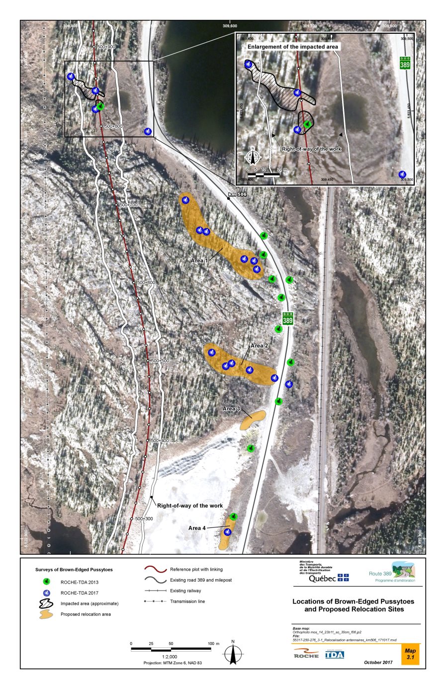
Source: MTMDET, 2017, page 15.
6.2.3 Mitigation, monitoring and follow-up measures
Mitigation measures
The proponent identified a number of measures for mitigating the project's effects on forest stands, wetlands and the brown-edged pussytoes (see Appendix B). The following are a few examples of the measures proposed:
General measures
- Ensure that machinery arriving at the work site is free of invasive species residues;
- Set up the work site facilities in locations that are already disturbed or sites with bare soil. However, if no disturbed location is available, tree cutting will be kept to a minimum;
- Establish clear boundaries of the work areas and identify it so that no encroachment beyond them will be allowed;
- Prohibit traffic outside of the identified access roads, crossings and work sites.
Measures for wetlands
- Limit the number of watersheds affected, in order to prevent impacts on the hydrological regime of the wetlands;
- Prohibit disposal of woody debris or natural waste material in the flood plain and in wetlands such as swamps and peat bogs, even outside areas directly affected by the work;
- Use sites that have already been cleared of vegetation or otherwise disturbed for temporary site installations (site office, construction camps, access road, etc.);
- If a section of the current road passing through a wetland must be reconstructed or enlarged, first reduce the encroachment on the wetland to the extent possible. Various techniques can be used for that purpose: infill with blasted rock, retaining walls, reinforced soil, geotextiles and geogrids, etc. Choose techniques conducive to rapid regrowth of vegetation (e.g. geotextiles, geogrids);
- In riparian habitats, renaturalize the shoreline affected by the work at watercourse crossings;
- Renaturalize the banks affected by the works to the crossings of the rivers;
- Take all necessary precautions to avoid altering the flow and drainage conditions in the remaining parts of the peatlands that will be affected by the project.
Measures for brown-edged pussytoes, special-status species
For individuals located outside the highway right-of-way:
- Report their presence and prohibit any traffic or activity around them;
- Avoid disturbing the surface layer of soil nearby;
- Carry out work during the period when snow cover provides protection for the species;
- Delineate a perimeter around the species' habitat to protect it from microclimatic alterations produced by an edge effect.
For individual plants located within the highway right-of-way:
- Relocate individual plants, under the supervision of a competent botanist, to similar suitable habitats conducive to their growth;
- Refine the area to be protected around the individuals and the natural habitat surrounding them.
The proponent presented a protocol in which it proposes transplanting the plants located within 600 m of the right-of-way in four sectors where the brown-edged pussytoes is already present, plus one experimental site where it is currently absent (Figure 8). The transplantation methodology was considered adequate by the MDDELCC.
With regard to compensation for the loss of wetlands, the Government of Quebec adopted the An Act respecting the conservation of wetlands and bodies of water on June 16, 2017. Under this provincial law, compensation for wetland losses must now be in the form of a financial contribution. However, the government is proposing a new compensation regulation for wetland and water damage, and it plans that no compensation will be required for projects in north of the 49th parallel. Thus, if the regulation is adopted prior to the issuance of provincial authorizations, no financial compensation for the loss of wetlands would be required. Otherwise, the proponent estimated that the compensation to be paid in the form of a financial contribution for the loss of wetlands related to its project would be 2.64 million dollars.
Monitoring and follow-up
The proponent indicates that it intends to implement a monitoring program during the construction phase, which will include the application of mitigation measures as well as the specific requirements of government authorities, where applicable. These measures would be incorporated into plans and specifications in order to be known and applied by the contractors who will carry out the work. Wetlands as well as all revegetation work (reforestation, banks redevelopment) will be subject to specific and sustained monitoring. Adaptive management measures will be put in place if the planned measures are not effective or if adverse effects are observed. In its follow-up program, the proponent plans to monitor the renaturalization of abandoned portions of roads and borrow pits. Special monitoring will be carried out over a period of five years to ensure the successful transplantation of brown-edged pussytoes. Follow-up would occur during the flowering period (July – August), and the following data would be gathered: extent (%) of the brown-edged pussytoes, number of living rosettes, number of stems and flowers, cover (%) by species of vegetation layers, health of the plants, and disturbance index. The follow-up program would be submitted to the MDDELCC for comments and approval, as well as the results of the follow-up.
6.2.4 Comments received
Federal government authorities
Environment and Climate Change Canada is satisfied with the description of the wetlands and their functions, including their function as habitat for migratory birds and species at risk. Environment and Climate Change Canada states that the mitigation measures proposed by the proponent to reduce the environmental effects on wetland functions (particularly as migratory bird habitat) appear to be adequate. Environment and Climate Change Canada considers that avoiding work in the wetlands is the best mitigation measure and notes that the proponent has proposed to apply the principle of avoiding wetlands or minimizing the effect on them, beginning with the design phase of the project.
Concerning the brown-edged pussytoes, the MDDELCC reviewed the protocol and methodology of transplantation submitted by the proponent and considers that the proposed protocol is adequate and that the risk of breakage of stolons and roots is low. Based on the information provided, MDDELCC's view is that the transplants should be very successful.
MDDELCC proposed changes to the transplant protocol submitted by the sponsor. He indicated that sectors 3 and 4 (Figure 8) should be excluded from the transplanting sites, since even though they are similar to the original site, they show signs of disturbance. He also suggested that the transplanting period should correspond to the end of the growing season, rather than a season of the year. The proponent has committed to consider these requests.
MDDELCC is of the opinion that if the proposed modification to the transplanting protocol is applied, it will adequately meet the biological requirements of the brown-edged pussytoes and that its effectiveness would be appropriately validated by means of the five-year follow-up planned by the proponent. MDDELCC asked the proponent to submit a file containing the locations of all of the transplanted and untransplanted plants to the Centre de données sur le patrimoine naturel du Québec.
First Nations
The Uashat mak Mani-Utenam Innu First Nation expressed concerns about the impacts of forest clearing and the destruction of wetlands on use of the land for traditional purposes. It also pointed out the absence of compensation measures for the loss of wetlands. The Agency notes that, since the expression of this concern, the proponent has further reduced the footprint of its project in wetlands and the mitigation measures may limit the loss of functions of affected communities.
General public
No comments were received from the general public about the project's effects on the wetlands and special status plant species component.
6.2.5 Agency's analysis and conclusions
The Agency is of the view that the Project is not likely to have significant adverse effects on wetlands and brown-edged pussytoes, given the application of proposed mitigation measures and monitoring and follow-up programs.
The Agency, based on the expert opinion of Environment and Climate Change Canada, estimates that the intensity of the effects of the project on wetlands would be moderate since losses represent low proportions that would not affect abundance and the distribution of this component, which is abundant and widespread in the study area. Indeed, the region in which the project is located has an abundance of wetlands and particularly peatlands. The study area is not located in a geographic area where wetland losses or their functions require special measures as per Annex 2 of the Implementation Guide for Federal Land Managers (EC, 1996). At the provincial level, the proposed draft regulations Compensation for adverse effects on wetlands and bodies of water indicates that wetlands north of the 49th parallel would not need to be compensated. The loss or degradation of wetlands in this region would not be an issue. However, some habitat functions of species at risk could be disturbed without affecting this species.
The proponent also demonstrated that the principle of avoiding and minimizing effects was applied from the design stage of the project. Lastly, no wetland with a high ecological value would be affected or disturbed by the work or the road, and no habitat function of a species with a special status would be affected to the extent that it has consequences for the maintenance of the population of this species. Special monitoring will be put in place to ensure that the mitigation measures put in place are adequate and effective.
The Agency is of the opinion that the intensity of the effects of the project on the brown-edged pussytoes would be average since the affected individuals would be transplanted in favorable zones with a high potential of success according to the experts of MDDELCC. A five-year follow-up would also validate the effectiveness of this transplantation appropriately according to the MDDELCC. The proponent would consult the experts of the MDDELCC, responsible for the conservation of this plant species, for advice and support.
6.3 Fish and Fish Habitat
This section presents the analysis of the project's effects on fish and fish habitat as defined in the Fisheries Act, taking into consideration eggs, spawn, larvae, fish and all areas on which fish depend to carry out their life processes, including spawning, nursery, rearing and feeding areas.
According to the Agency, a significant residual adverse effect is one that would result in the death of any fish, the permanent alteration or the destruction of its habitat, which could not be offset through a compensation plan under the Fisheries Act. The Agency's criteria for evaluating environmental effects and the grid used to determine the significance of the effects are presented in Appendices D and E, respectively.
For this project, the effects examined are those related to habitat loss caused by the construction of seven bridges and 23 culverts at points where the new road crosses watercourses, the installation of embankments along the road near certain waterbodies and the construction of culverts for the various access roads, as well as the alterations to the quality of habitat associated with degradation of water quality due to inputs of suspended solids, metals, and other contaminants.
Based on its analysis, the Agency concludes that the project is unlikely to result in significant adverse environmental effects on fish and fish habitat, given the mitigation measures and monitoring and follow-up programs proposed by the proponent:
- Construction of the highway would cause the loss of 1.31 ha of fish habitat; however, that loss could be offset in accordance with the Fisheries Act.
- Given the mitigation measure, it is unlikely that there would be an increase in the concentrations of suspended solids, metals, and other contaminants to the point that they would affect fish and fish habitat.
The following subsections describe the baseline conditions and the essential elements of the proponent's analysis, the opinions of the expert departments, the First Nations and the general public, on which the Agency based its conclusion regarding the significance of the project's effects on fish and fish habitat.
6.3.1 Baseline conditions
The study area proposed by the proponent for assessing the project's effects on fish and fish habitat include 300 metres downstream and 200 metres upstream in the watercourses which the road will cross. It also included the four options for the route of the access road to Lac De La Rue and the watercourses within the boundaries of the borrow pits and those that will be crossed by temporary roads.
To characterize the fish habitat and water quality, the proponent conducted surveys from July 4 to 12, 2013, at 20 stations in watercourses that the road is likely to cross (Figure 9). The watercourses are located in three watersheds, those of Petite Rivière Manicouagan, Rivière aux Pékans and Carheil Lake.
Twelve species of fish were captured in the affected watersheds, including the lake whitefish, northern pike, brook trout, burbot, lake trout, and carp (Cyprinidae). No fish species at risk listed in Schedule 1 of the Species at Risk Act is present in the watercourses or water bodies in the study area.
In all, the new road will cross 29 watercourses and water bodies, including Petite Rivière Manicouagan, Rivière aux Pékans and Lac De la Rue. Free fish passage was assessed for each of the crossings and was deemed to be required for 21 watercourses and water bodies affected by permanent infrastructure (bridges and culverts).
According to the proponent, in Petite Rivière Manicouagan, the habitats crossed by the road are heterogeneous and would allow the various fish species to complete their life cycle. A deeper section upstream from the crossing could be used by brook trout as a thermal refuge during the summer, while certain smaller and shallower riffles could be potential spawning grounds for brook trout and other species. Lastly, the areas with slow-moving waters and aquatic grass beds are likely to be used by the northern pike for feeding, spawning and rearing.
According to the proponent, the Rivière aux Pékans offers good-quality habitats for various fish species. The high-current areas and the deep pools, like those at the crossing, can be used by brook trout for feeding and refuge. The waterway of the river north of the road alignment, where aquatic plants grow, is an excellent feeding, spawning and rearing site for northern pike and other species.
According to the proponent, fish are most likely to use the habitats at the crossing of the Lac De la Rue, for feeding and movements. No potential spawning sites at the crossing site for any of the species present in the lake was identified.
The other watercourses that would be crossed by the road are smaller (less than 4 m wide) but nevertheless offer varied habitats that are generally of good quality, primarily for brook trout.
The water quality measurements taken at the watercourse crossings by the proponent indicate that it varies widely from site to site. Five parameters were measured: temperature, pH, dissolved oxygen, conductivity and turbidity.
Water temperature varies between 6.30°C and 21.60°C and the pH varies from acidic (6.70) to basic (7.65). Dissolved oxygen concentration and saturation vary between 8.05 and 11.46 mg/L and between 77% and 99.90%, respectively. The proponent states that water quality is generally good, with a high rate of oxygenation, and that the water is relatively clear, transporting small amounts of suspended solids.
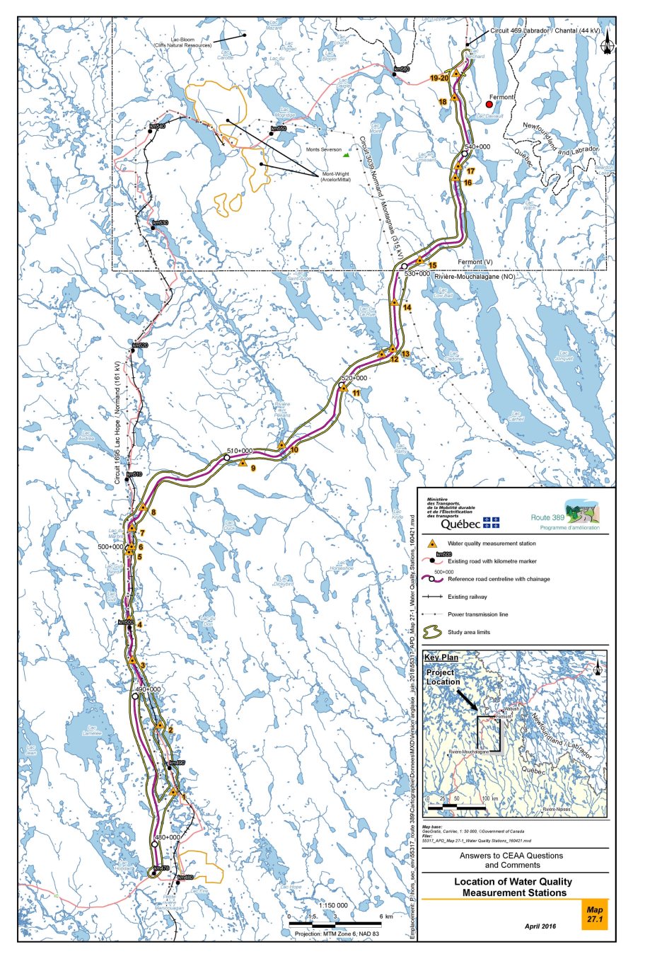
Source: MTMDET, 2016, page 133.
6.3.2 Proponent's assessment of the environmental effects
Anticipated effects
According to the proponent, the project's potential adverse effects on fish and fish habitat are linked to the loss of habitat due to encroachment, to obstacles to the free passage of fish and to the degradation of water quality. The proponent considers that the project will not have significant adverse effects on fish and fish habitat.
Degradation of water quality
The construction work would be likely to produce effects on fish habitat by generating inputs of fine particulate matter. Construction of the bridges, installation of the culverts and operation of the borrow pits would require tree cutting, grading and digging in or near the watercourses. That could cause input of fine particulate matter into the watercourses and an increase in turbidity, which would affect fish habitat downstream from the work area. Sediments could also be transported toward the aquatic habitat for the use and maintenance of the road and the drainage ditches during the operating phase. The proponent indicated that a high level of turbidity could have adverse effects on fish habitat, particularly spawning areas, as well as adverse physiological and behavioural effects on fish. The proponent also indicated that clearing of trees could expose the watercourses to more sunlight, which could cause an increase in water temperature.
The construction work could also generate inputs of organic matter and nutrients (nitrogen, phosphorus) into the watercourses, and thereby contribute to the growth of periphyton Footnote 17 and algae. This growth could degrade fish habitat by reducing the amount of dissolved oxygen in the water.
Surface waters could also be contaminated by various substances, including the heavy metals contained in vehicle exhaust. During an accident or a mechanical breakdown, spills of hydrocarbons and other liquids could occur and reach the watercourses. In addition, during the operating phase of the road, the use of abrasives and maintenance of the ditches could affect water quality.
The proponent stated that the risks of metal leaching and of acid mine drainage associated with the borrow pits are very low. It based this assessment on analyses conducted at the Fire Lake North, Mont Wright and Bloom Lake mine sites which showed that mine residue did not generate acids and are low-leaching. Since the project study area is less mineralized, even lower concentrations are expected. Consequently, exposure of the materials contained in the borrow pits to air and water should not present problems, other than that of suspended fine particulate matter.
Encroachment of infrastructure on fish habitat
Currently, it is estimated that the construction of bridges and culverts as well as placement of fill in lac along the roadside would cause permanent loss of about 11,192 m2 of fish habitat (Table 7). On the other hand, the implementation of temporary structures, such as cofferdams for the development of bridge abutments or temporary diversions of watercourses for the construction of culverts for example, would result in temporary encroachments of 2000 m2 in fish habitat.
|
Work to be carried out |
Habitat losses (m2) |
|
|---|---|---|
|
Temporary |
Permanent |
|
|
Source: MTMDET, 2018b, page 9. |
||
|
Construction of 23 culverts and seven bridges (for the projected route) |
2,000 |
8,982 |
|
Construction of nine culverts for the access roads to the borrow pits and to Lac de la Rue |
0 |
360 |
|
Placement of fill along the roadside in waterbodies |
0 |
1 850 |
|
Total |
2,000 |
11,192 |
6.3.3 Mitigation, monitoring and follow-up measures
Mitigation measures
The proponent undertakes to implement a number of measures (see Appendix B) to minimize and mitigate the effects of the road construction on fish and fish habitat. Those measures involve different components, including the project schedule, control of erosion and sediment transport, temporary structures, blasting, watercourse restoration and site reclamation. The proponent has also committed to implementing certain permanent measures for limiting sediment input into watercourses, such as paving the bridges and their approaches. These measures are intended to minimize the impact of the work on fish and fish habitat. The proponent's planned measures include the following:
- Maintain free passage of fish into watercourses where deemed necessary, to the satisfaction of Fisheries and Oceans Canada. To do this, the proponent could, for example, meet the design criteria presented in the document Guidelines for Planning River Crossings in Quebec (2016).
- To reduce sediment inputs from road runoff, apply asphalt pavement (paving) over bridges and approaches over a minimum distance of 155 metres on both sides to mitigate this element of the project.
- Conduct water interventions outside the sensitive period for fish, including brook trout, lake whitefish and northern pike, and minimize the duration of work in the aquatic environment. Specifically, perform water interventions during the following periods:
- ? Presence of salmonids (brook trout, lake whitefish, etc.): June 1-September 15;
- ? Presence of other species: August 1-April 15.
- Limit deforestation to the minimum required on both sides of the high water mark and keep the vegetation cover as long as possible before work begins.
- Limit stripping, clearing, excavation, filling and grading of the work sites.
- Put in place effective measures to limit the intake of sediments from the site to the aquatic environment and ensure their maintenance (e.g.: sediment barrier, berms, sediment trap, sedimentation basin, temporary stabilization of slopes, deviation of waters to areas of vegetation). The measures must remain effective during periods of flood, during heavy rains or during frost.
- During operations, ensure adequate and regular maintenance of ditches and sedimentation basins to optimize their effectiveness in capturing suspended solids to prevent their discharge into watercourses and bodies of water.
The proponent has undertaken to offset serious harm Footnote 18 to fish as prescribed by the Fisheries Act and to the satisfaction of Fisheries and Oceans Canada. To this end, the proponent proposes to restore the free passage of fish to between 15 and 20 different sites in the area of Route 389 between Fire Lake and Fermont and in the Relais Gabriel area, south of the project. Some structures would be dismantled (existing road sector to be dismantled), while others would be replaced by structures allowing the free passage of fish.
Monitoring and follow-up
The proponent has also undertaken to implement the following monitoring and follow-up programs:
The monitoring program will ensure that mitigation measures put in place to reduce the effects on fish and fish habitat are effective at all times during the construction phase and to make corrections as needed. The following elements would be part of the monitoring program:
- Soil protection against erosion, especially near watercourses.
- Protection of water quality (especially river crossings and construction of structures).
- Measures to prevent leakage of contaminants and management of contaminated soils.
- All revegetation works (reforestation, shoreline redevelopment).
The proposed monitoring program includes:
- Monitoring the passage of fish in culverts where the free passage of fish is required.
- Monitoring of rehabilitations and reconstructions of watercourses near culverts.
- Monitoring of the fish habitat compensation plan.
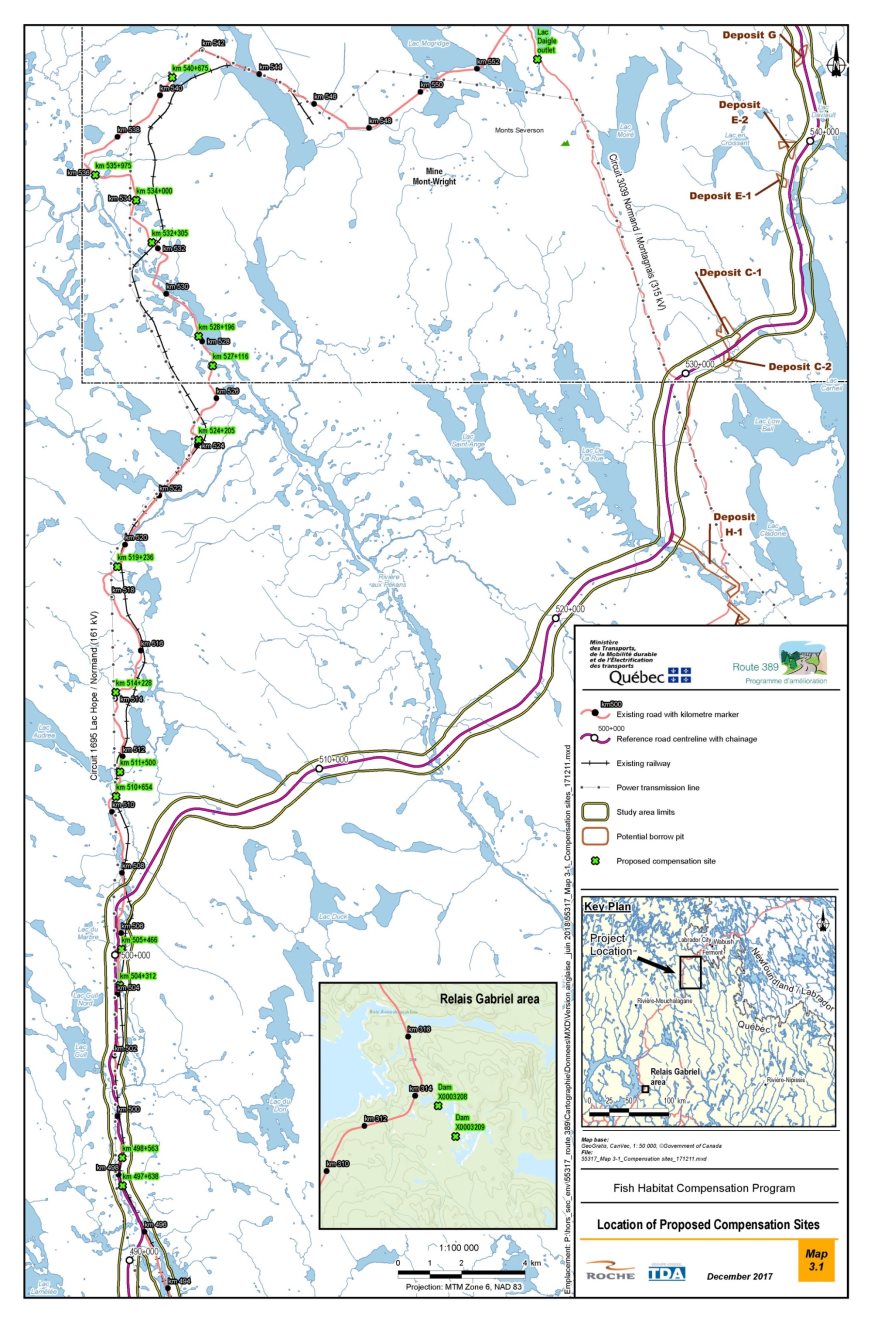
Source: MTMDET, 2018, page 6
6.3.4 Comments received
Federal government authorities
Environment and Climate Change Canada considers that the proponent has adequately documented the effects of the road's presence on water quality. It is satisfied with the proponent's intended mitigation measures for protecting water quality. Their implementation, conformance to standards, and the application of sound management practices are key elements in protecting water quality. Environment and Climate Change Canada is of the view that, if all the mitigation measures proposed by the proponent are implemented in a timely fashion, the project's effects on water quality would be kept to a minimum. Environment and Climate Change Canada indicates that, in the context of an unpaved road, ensuring proper and regular maintenance of ditches and sedimentation basins to optimize their effectiveness in capturing suspended solids is an important measure to avoid their discharge into watercourses or waterbodies.
In addition to limiting the surfaces to be cleared and revegetating all work site surfaces, Environment and Climate Change Canada notes that quick action should be taken to restore the borrow pits after the construction phase and revegetate the surfaces exposed to erosion.
Environment and Climate Change Canada support the proponent in the application of the Bureau de normalisation du Québec's standard (BNQ 2410-300), among others, when using dust suppressants based on hygroscopic chloride salts.
Fisheries and Oceans Canada considers that the Route 389 Improvement Project between Fire Lake and Fermont (kilometres 478 to 564) would cause the permanent alteration and the destruction of approximately 1.31 ha of fish habitat, which would result primarily from the encroachments of the bridges and culverts in de watercourses and the fill in the watercourse along the road, as well as temporary structures required for their construction.
Fisheries and Oceans Canada noted that the work methods for this project are likely to cause adverse effects on fish and its habitat. They should be clearly indicated in order to limit the risks of causing additional significant effects on fish habitat. Fisheries and Oceans Canada also Zindicated that the mitigation measures to be implemented would reduce the effects of the work on fish and fish habitat. Fisheries and Oceans Canada also noted that serious harm to fish and its habitat would be acceptable and could be offset. Although some elements still need to be specified, the scope of the compensation program proposed by the proponent seems sufficient to offset the serious harm to fish and its habitat.
In light of this information, Fisheries and Oceans Canada takes the view that the potential effects of the project's potential effects on fish and fish habitat would be prevented, mitigated and offset, in conformance with the Fisheries Protection Policy Statement (DFO, 2013).
First Nations
The Councils of the Matimekush-Lac John Innu First Nation and the Uashat mak Mani-Utenam Innu First Nation raised concerns about the reduction in water quality due to soil erosion and deposition of sediment in the watercourses associated with the construction and dismantling of culverts and bridges.
The two First Nations also expressed concerns about the accuracy of the fish surveys and the water quality data. They consider that the proponent should have carried out the survey in all the watercourses where the habitat was characterized. According to the First Nations, the proponent should have done a characterization and a survey for the Moisie River and Carheil Lake. They also stated that they were very concerned about the project's effects on the Rivière aux Pekans and the Moisie River. The Agency wishes to reiterate that additional information may be asked and requested and requested by Fisheries and Oceans Canada during the review and authorization phase. Where applicable, requests will be made to proponent as required during the regulatory phase and additional characterizations may be requested as required.
The Matimekush-Lac John Innu First Nation is concerned about the effects of the opening up of their ancestral land to resort-based activities. Those activities could cause more pressure on brook trout and other fish and wildlife species.
The Uashat mak Mani-Utenam Innu First Nation also noted that the new road will cross the planned Moisie River aquatic reserve, notably in the form of the planned Rivière aux Pékans crossing. In their view, it is unfortunate that the corridor for the future Route 389 would have to be taken from the territory of the aquatic reserve (like the current right-of-way for the existing road). The Agency states that the proponent has worked with the MDDELCC to ensure that the construction and operation of the road has less impact on the proposed aquatic reserve. The route was modified during the environmental assessment for this reason.
For trapline 255, the Grégoire family feard that the decline of fishing, which is already apparent due to increased pollution in the lakes and rivers caused by intensification of mining activity in the area, will be aggravated following the project of improving Route 389.
General public
No comments were received from the general public about the project's effects on fish and fish habitat.
6.3.5 Agency's analysis and conclusions
In the Agency's view, the project is unlikely to result in significant adverse environmental effects on fish and fish habitat, as well as on water quality, given the proposed mitigation measures and the monitoring and follow-up programs.
The intensity of the effect is considered medium, as the project would result in losses of habitat that would be offset, as well as low inputs of fine particulate matter and contaminants in the watercourses which would not limit or reduce the ability of fish to use those habitats. The Agency is also of the opinion that maintaining the free passage of fish in the watercourses, where it was deemed necessary, would reduce the potential impacts associated to the project.
The extent of the effect would be isolated, as it would be limited to the sites where the road crosses the watercourses. The duration of the effect would be long, as the road is permanent. The Agency notes that the project will result in residual losses of 1.31 ha of habitat that would be offset by various interventions, to the satisfaction of Fisheries and Oceans Canada.
The Agency is of the opinion that the measures planned by the proponent would adequately mitigate the project's effects on fish habitat related to degradation of water quality.
The Agency also notes that the proponent has planned various follow-ups, including monitoring the free passage of fish in new road culverts, monitoring the rehabilitations and reconstructions of watercourses at culvert approaches and monitoring the effectiveness of the measures to counteract serious damage to fish and its habitat. The results of these follow-ups would enable the proponent to take corrective action if necessary.
6.4 Birds and Bird Habitat
This section sets out the analysis of the project's effects on birds, a valued component that consists of migratory birds, covered by the Migratory Birds Convention Act, 1994, and non-migratory birds, their eggs, nests and habitats, including federally and provincially designated special-status species. Migratory birds include land birds,Footnote 19 shorebirds, water birds and waterfowl that are listed under the Migratory Birds Convention Act, 1994. Some of these species are listed on Schedule 1 of the federal Species at Risk Act or designated under the Quebec Act respecting threatened or vulnerable species.
According to the Agency, a significant adverse residual effect results from habitat loss and degradation, incidental take Footnote 20 or any nuisance that can cause the decline of a bird population or hinder the recovery of one or more bird species at risk that are covered by a recovery strategy within the meaning of the Species at Risk Act. The Agency's criteria for assessing environmental effects and the grid used to determine the significance of the effects are presented in appendices D and E, respectively.
In this project, the effects assessed relate to the loss, disturbance and fragmentation of habitats suitable for birds as well as to mortality and disturbance of birds, their nests or their eggs.
Based on its analysis, the Agency concludes that the project is not likely to cause significant adverse environmental effects on birds, taking into account the implementation of the proposed mitigation measures and monitoring and follow-up programs.
- The permanent loss of approximately 500 hectares of bird habitat would not cause a decline in bird populations and would not hinder the recovery of populations of bird species at risk, taking into account the availability of a sufficient amount of similar habitats in the study area.
- Project risks associated with migratory bird and bird species at risk mortality (incidental take) are low and disturbance would be limited at the project site. Activities likely to conflict with nesting birds will be carried out outside the nesting season and special attention will be paid to reduce the risk of incidental take.
The following subsections describe the baseline conditions and the essential elements of the proponent's analysis, the opinions of expert departments as well as those of First Nations and the public, on which the Agency based its conclusion regarding the significance of the project's effects on birds and bird habitat.
6.4.1 Baseline conditions
The general study area was selected for the assessment of the project effects on land birds and water birds. A specific study area, corresponding to 800 metres on either side of the new road, was selected for birds of prey (see Appendix A).
The study area is located in the boreal zone and spans three bioclimatic domains. From south to north, they are the balsam fir–yellow birch domain, the spruce–moss domain and the spruce–lichen domain. The forest stands cover 4,269 ha and are essentially made up of coniferous forest dominated by black spruce. These are mainly spruce-lichen (28.1%), spruce-moss (48.6%) and balsam fir–yellow birch (5.4%).
The wetland description of the project study area is presented in Section 6.2 on wetlands and special-status plant species.
To provide a portrait of the avifauna in nesting season, the proponent carried out surveys of water birds (including waterfowl), birds of prey and land birds and used data from the Atlas of Breeding Birds of Southern Québec (AONQ, 2011) to improve its information. Special attention was given to bird species with precarious status under Schedule 1 of the Species at Risk Act, the Committee on the Status of Endangered Wildlife in Canada (COSEWIC) and the list of endangered or vulnerable wildlife species in Quebec. Use of the study area during other periods of the year was described using existing data including those from the eBird database (Cornell Lab of Ornithology, 2016).
In the study area, the proponent identified seven species of Anatidae (Canada Goose, American Black Duck, Mallard Duck, Ring-necked Duck, Common Goldeneye, Red-breasted Merganser and Surf Scoter), but only the nesting of Canada geese has been confirmed. The surveys found a total of 18.5 indicated breeding pairs of Anatidae, for a density of 9.1 breeding pairs per 25 km2. The most abundant water bird species in the study area is the Canada Goose, followed by the American Black Duck.
For other aquatic species, five Loonie pairs (density of 2.5 breeding pairs per 25 km2) were recorded in the study area and a Herring Gull was observed. No specific inventory has been conducted for Waders since, according to the proponent, the habitats in the general study area are not favorable to these species. However, according to data from the Atlas of Breeding Birds of Southern Québec (AONQ, 2011), the nesting of seven Wader species is confirmed and that of another is likely in the 19FU parcel block targeted by the study area. The following species, however, were observed during the promoter's various biological inventories: Spotted Sandpiper, Wilson's Snipe, Solitary Sandpiper and Greater Yellowlegs.
According to the data (block 19FU) of the Atlas of Breeding Birds of Southern Québec (AONQ, 2011), 49 terrestrial bird species could be present in the study area. Of this number, nesting of 21 species has been confirmed.
The inventories conducted by the proponent identified 39 terrestrial bird species, 11 species of which are considered confirmed, eight species as probable and 20 species as possible. The most abundant species are the White-throated Sparrow, the Ruby-crowned Kinglet, the Dark-eyed Junco, the Fox Sparrow and the Hermit Thrush.
Finally, the presence of four species of special status birds has been confirmed in the study area. Rusty Blackbird (special concern status under the Species at Risk Act and likely to be designated as threatened or vulnerable in Quebec), Olive-sided Flycatcher (threatened status under the Species at Risk Act and likely to be designated as threatened or vulnerable in Quebec), Common Nighthawk (threatened status under the Species at Risk Act and likely to be designated as threatened or vulnerable in Quebec) and Bank Swallow (threatened status under the Species at Risk Act).
The project is also in the range of the threatened Barn Swallow listed on Schedule 1 of the Species at Risk Act. However, the proponent concludes that the study area would not be a suitable habitat for the species and is unlikely to be encountered.
With respect to the Red-necked Phalarope, a species designated as of special concern by the Committee on the Status of Endangered Wildlife in Canada, the proponent states that no individuals were observed during the surveys and that the study area is at the southern limit of the breeding range. The Atlas of Breeding Birds of Southern Québec reports records of this species (for which breeding is considered probable or confirmed) in five parcels located within a fifty-kilometre radius of the study area (AONQ 2016). The eBird database includes a single Narrow-necked Phalarope record for the Labrador City site, an individual observed on August 30, 2003 (Cornell Lab of Ornithology, 2016). Considering the date of the observation, it must have been a migratory individual. However, the proponent considers that it is unlikely that the species is in the study area, but that the potential for presence remains.
The only species of birds of prey with a precarious status (vulnerable according to the Quebec Act respecting threatened or vulnerable species) that has been observed in the study area is the Bald Eagle. Nesting, however, has not been confirmed. Historic nesting sites have been identified approximately 27 km south-southeast of observations of Eagle (2013 inventory) at Lake Daviault.
The proponent has indicated, based on an assessment of the species' potential for occurrence, that the Short-eared Owl (a species at risk) is unlikely to be found since the habitats in the study area do not possess the characteristics required for the reproduction of the species.
The group of Tetraonidae (non-migratory species under the Migratory Birds Convention Act, 1994), which includes Ruffed Grouse, Spruce Grouse, and Willow Ptarmigan, have been described and treated together as it has not been possible to distinguish their tracks. In total, 52% of riparian segments and 26% of forest transects had tetraonid tracks. These species are therefore strongly represented at the scale of the study area. According to the proponent, tetraonid abundance indices were slightly higher in the southern sector compared to the central and northern sectors of the proposed route.
With respect to the relative densities of biotopes present in the study area, shrublands are the habitat with the highest density of pairs with 7.77 breeding pairs / 20 min / ha. They are followed by closed spruce stands with 5.22 breeding pairs / 20 min / ha. Open spruce stands, peat bogs, burns, and deciduous stands show similar densities ranging from 4.09 to 4.50 breeding pairs / 20 min / ha. The biotope that appears to be the poorest consists of herbacities with only 2.55 breeding pairs / 20 min / ha. Finally, the average relative density of breeding pairs throughout the study area is 4.54 breeding pairs / 20 min / ha.
6.4.2 Proponent's assessment of environmental effects
According to the proponent, potential adverse effects of the project on avifauna would relate to the loss, disturbance and fragmentation of nesting habitat; nest destruction; disturbance of birds and nests by changes to the noise environment; and vehicle collision mortality.
Habitat loss, disturbance and fragmentation
The construction of the project would result in the loss of 451.57 ha of forest stands, including 203.97 ha for the road and 247.59 ha for the borrow pits. According to the proponent's calculations, 96% of the potentially affected areas are occupied by the black spruce-moss forest and the black spruce-lichen forest (Table 8). Specifically for the road right-of-way, 4.78% of the forest stands in the study area would be lost.
The four types of stands that would be most affected for road construction are very common at the regional level. These are the black spruce-lichen, black spruce-tamarack, black spruce-moss and black spruce-balsam fir. In the case of borrow pits, forest stand losses would be temporary, since the sites of the borrow pits would be revegetated as a result of their exploitation. Other habitat losses used by Anatidae and Gaviidae include the loss or disturbance of 0.48 ha of water bodies, 29 watercourses and 26 peat bogs.
|
Unit |
Study area (road) |
||
|---|---|---|---|
|
Existing |
Impacted |
||
|
ha |
Impact (ha) |
Impact (%) |
|
|
Source: MTMDET, 2015, page 53 and MTMDET, 2018a page 3 |
|||
|
Forest stand |
4,268.88 |
451.57 |
10.59 |
|
White spruce–jack pine |
4.40 |
0.00 |
0.00 |
|
Black spruce–lichen |
1,433.77 |
269.99 |
18.83 |
|
Black spruce–tamarack |
32.37 |
1.88 |
5.81 |
|
Black spruce–moss |
2,479.29 |
162.79 |
6.57 |
|
Black spruce–balsam fir |
274.66 |
16.91 |
6.16 |
|
Balsam fir–black spruce |
0.52 |
0.00 |
0.00 |
|
White birch |
43.87 |
0.00 |
0.00 |
|
Wetland |
234.78 |
12.56 |
5.35 |
|
Peat bog |
221.00 |
11.75 |
5.32 |
|
Marsh |
1.07 |
0.00 |
0.00 |
|
Shrub swamp |
12.71 |
0.81 |
6.37 |
|
Other |
595.84 |
29.55 |
4.96 |
|
Human-modified areas |
169.61 |
4.72 |
2.78 |
|
Regeneration |
52.83 |
3.10 |
5.87 |
|
Burns |
51.97 |
0.82 |
1.58 |
|
Dry, bare areas |
21.27 |
1.41 |
6.63 |
|
Water |
297.59 |
0.48 |
0.16 |
|
Island |
2.57 |
0.00 |
0.00 |
|
Total |
5,099.50 |
493.67 |
9.68 |
According the proponent, 6.5 indicated breeding pairs of Anatidae would see their breeding habitat (nesting and brood rearing) affected by the construction of the road. Certain shorebird species could also be affected by habitat loss. For example, the loss of wetland and forest habitats caused by construction of the road and borrow pits could affect nearly 6 Wilson's Sniper and Spotted Sandpiper breeding pairs, 1 Solitary Sandpiper breeding pair and 4 Greater Yellowlegs breeding pairs.
In the case of land birds, breeding habitat losses could affect 2,009 breeding pairs, with 941 pairs affected by the road construction work and 1,068 by the operation of borrow pits.
The proponent estimated that wetland losses could affect 37 breeding pairs of land birds, primarily the White-throated Breeding Sparrow, Lincoln's Sparrow and Dark-eyed Junco (Table 9).
With regard to the effects on bird species at precarious status, the proponent estimated that at least 2 Rusty Blackbird breeding pairs would lose part of their nesting habitat since the new road right-of-way would traverse two peat bogs used by the species. The construction of the road could also disturb 24 other peat bogs and four shrub swamps, for a total of 12.56 ha of habitat. It is therefore possible that additional pairs will see some of their nesting habitats impacted by the project. The proponent considers that it is likely that these breeding pairs of Rusty Blackbirds will, however, be able to find new breeding habitats relatively easily since, according to the Rusty Blackbird management plan (Environment Canada, 2015a), it is the wintering habitats and which would be limiting for the species and not the breeding habitats.
The proponent also determined that at least two Olive-sided Flycatcher breeding pairs would lose part of their breeding habitat as a result of construction of the road and that one or two pairs could see their nesting habitat affected by borrow pit operations. It is also likely that the presence of the road within the habitats of the species reduces its overall quality. It is therefore possible that Olive-sided Flycatcher breeding pairs leave impacted environments and move to other areas. Depending on the habitat characteristics sought by the species (open coniferous forests, burns, wetlands), approximately 73.0 ha of habitat suitable for the species will be destroyed by the construction of the road and 205.2 ha of black spruce–lichen by the exploitation of the borrow pits. According to the proponent, the impacts of the operation of the borrow pits should be minimized since wetlands and water are not affected by the project and a 20 metre wide strip of woodland (measured from the high water) would be kept on the edge of these. Finally, according to the proponent, breeding pairs who would be affected by the construction of Route 389 would have no difficulty in finding new suitable breeding habitats in the study area. However, according to the recovery strategy for these species (Environment Canada, 2016b), the causes of the decline in Olive-sided Flycatcher numbers are poorly understood and may be related to the loss or deterioration of their habitats.
Depending on the habitat characteristics of Common Nighthawk, road construction and borrow pit operations would affect 85 ha and 223.6 ha of potential habitat for Common Nighthawk, respectively. It is estimated that not more than one Common Nighthawk pair would be affected by construction of the road and at least one pair would be affected by borrow pit operations. Based on the Recovery Strategy for Common Nighthawk (Environment Canada, 2016a), the causes of the decline of the species are multiple, but not yet fully understood.
The species is thought to be mainly threatened by the sharp decline in the number of flying insects on which it feeds and the reduction in the area of its breeding habitats (fire fighting, reforestation of grasslands, abandonment of farmland that naturally reforest, etc.). According to the proponent, these different threats would not particularly apply to the study area.
Three Bank Swallow colonies have been identified in the study area. The proponent indicates that it is not expected that the construction of the road will impact these colonies. The proponent states that the decline of the Bank Swallow does not appear to be related to a particular threat, but rather to the cumulative effects of several factors including loss of breeding and foraging habitat. According to him, in the project area, these factors are unlikely to influence the Bank Swallow.
|
Species |
Peat bogs and herbaceous meadows (loss of 7.32 ha) |
Shrubland (loss of 1.22 ha) |
Total number of pairs affected |
||
|---|---|---|---|---|---|
|
Density (pair/ha) |
Pairs affected |
Density (pair/ha) |
Pairs affected |
||
|
Source: MTMDET, 2016, page 154 |
|||||
|
Ruby-crowned Kinglet |
0.2 |
1.6 |
0.3 |
0.3 |
1.9 |
|
American Three-toed Woodpecker |
0.0 |
0.0 |
0.0 |
0.0 |
0.0 |
|
Northern Waterthrush |
0.0 |
0.0 |
0.3 |
0.3 |
0.3 |
|
Blackpoll Warbler |
0.0 |
0.0 |
0.5 |
0.6 |
0.6 |
|
Wilson's Warbler |
0.0 |
0.0 |
0.8 |
0.9 |
0.9 |
|
Yellow-rumped Warbler |
0.1 |
1.0 |
0.5 |
0.6 |
1.7 |
|
Alder Flycatcher |
0.0 |
0.0 |
0.6 |
0.8 |
0.8 |
|
Gray Jay |
0.4 |
3.1 |
0.0 |
0.0 |
3.1 |
|
American Robin |
0.0 |
0.0 |
0.5 |
0.6 |
0.6 |
|
Dark-eyed Junco |
0.6 |
4.7 |
0.5 |
0.6 |
5.3 |
|
Bohemian Waxwing |
0.1 |
1.0 |
0.0 |
0.0 |
1.0 |
|
Hermit Thrush |
0.2 |
1.6 |
0.0 |
0.0 |
1.6 |
|
Swainson's Thrush |
0.0 |
0.0 |
0.8 |
0.9 |
6.6 |
|
Solitary Sandpiper |
0.1 |
1.0 |
0.0 |
0.0 |
1.0 |
|
Lincoln's Sparrow |
0.8 |
5.7 |
0.8 |
0.9 |
6.6 |
|
White-throated Sparrow |
1.1 |
7.8 |
1.3 |
1.6 |
9.3 |
|
Fox Sparrow |
0.0 |
0.0 |
0.3 |
0.3 |
0.3 |
|
White-crowned Sparrow |
0.0 |
0.0 |
0.8 |
0.9 |
0.9 |
|
Total |
3.7 |
27.4 |
7.8 |
9.5 |
36.9 |
Mortality and disturbance to birds, nests and eggs
Activities such as forest clearing, grubbing, earthwork and levelling of the road and borrow pits could result in the destruction of forest bird nests if they are made during the breeding season. Noise from construction activities and the operation of borrow pits may disturb birds and disrupt their activities. Thus, according to the proponent, pairs of birds nesting near the construction and aggregate extraction sites could be stressed and ultimately abandon their nest. Couples could also move to other areas.
Once the road is built, the potential effects would be related mainly to mortality (incidental take) and disturbance of birds and nests. The use of roadside areas by birds poses a risk of collision with vehicles. Given the limited traffic volume that is expected, the risk of collision and noise-related disturbance appears to be limited.
For the Bank Swallow, if the availability of vertical slopes is limited in the area, it is possible that the operation of the borrow pits will lead to the creation of suitable slope habitat suitable for nesting this species. Thus, if individuals moved into these borrow pits, their nests could be destroyed if management measures are not put in place.
6.4.3 Mitigation, monitoring and follow-up measures
Mitigation measures
The proponent plans to implement a set of measures (see Appendix B) to mitigate the effects of the project on birds through habitat restoration and reduction in the risk of mortality and incidental take and reduction in noise-related disturbance. These measures include the following:
- Pay special attention to species at risk, such as Bank Swallow that may use borrow pits for nesting, and Common Nighthawk that can nest in bare spots.
- Revegetate the access roads and temporary work areas, the sections of the old road, the borrow pits following their exploitation. This renaturalization would be carried out to favor bird species at risk and boreal caribou.
- Avoid all activities (deforestation, stripping, mowing, etc.) that may conflict with nesting birds (nesting period).
- Limit to the strict minimum the area of land cleared.
- Restore vegetation cover along water courses as soon as the stream crossing work is complete.
- Restoring and revegetating the borrow pits once the associated operations are complete. Consider restoring borrow pits in such a way as to create suitable nesting habitat for bird species at risk.
- Raise worker awareness of the potential presence of bird nests in the work area, and more specifically Common Nighthawk nests on the ground in cleared areas with bare soil, as well as nests of the Bank Swallow which could nest in particular in the vertical walls of borrow pits.
- Protect nests as necessary with a buffer zone based on a setback distance appropriate to the species, until the young have permanently left the vicinity of the nest.
- Regularly monitor nests that have been accidentally discovered. This surveillance must be carried out by a specialist and in such a way as not to contravene nesting.
- Profound slopes in borrow pits used prior to the arrival of the Bank Swallow and throughout the nesting season, so that they are not attractive to nesting this species Footnote 21
Monitoring and follow-up
The proponent indicated its plan to implement a monitoring program during the construction phase to ensure that the mitigation measures are implemented and the specific requirements of government authorities are met, where appropriate. These measures would be incorporated into the plans and specifications to ensure that the contractors who carry out the work are aware of and apply them. Mitigation measures for migratory birds and bird species at risk will be specifically monitored. Adaptive management measures will be put in place as needed if the planned measures are not effective or adverse effects are observed.
The proponent plans to develop a follow-up program in order to verify the accuracy of the environmental assessment and determine the effectiveness of the measures implemented to mitigate the adverse environmental effects of the project on the Rusty Blackbird, Olive-sided Flycatcher, Bank Swallow and Common Nighthawk.
The proponent plans to conduct a survey prior to the start of forest clearing work in order to establish a new baseline making it possible to describe the use of the study area by the four species at risk concerned. Follow-up will be carried out once during the construction period and once every two years after the road is opened in order to check whether the work or the presence of the road would have an effect on the abundance of the breeding pairs or on habitat use. The results of this monitoring program would support adaptive management measures to mitigate unanticipated adverse environmental effects.
Finally, the proponent plans to develop and implement a restored area monitoring program that is favourable to bird species at risk to determine if habitats are changing according to the intended purposes.
6.4.4 Comments received
Federal authorities
In general, Environment and Climate Change Canada is satisfied with the description of avifauna use of the study area. According to Environment and Climate Change Canada, the proponent adopted a methodological approach recognized and adapted to the large groups of species likely to frequent the project sector. Environment and Climate Change Canada also notes that the proponent has paid special attention to species at risk potentially present in the study area. It notes that the description of potential habitats of species at risk potentially present in the study area is well documented and is consistent with species at risk recovery strategies or action plans or status reports from the Committee on the Status of Endangered Wildlife in Canada.
Environment and Climate Change Canada is generally satisfied with the description of the effects of the project on birds and states that it is important that the proponent carry out the project in a way to protect migratory birds and to avoid injuring, killing or disturbing migratory birds or destroying and disturbing their nests and eggs or taking them. Thus, Environment and Climate Change Canada considers that the mitigation measures proposed by the proponent are relevant to reduce the effects of the project on birds. Among these measures, the ones that Environment and Climate Change Canada considers essential are those related to the following principles:
- The prevention of any adverse effects on birds, their nests or their eggs (incidental take).
- The application of Environment and Climate Change Canada's avoidance guidelines for general migratory bird nesting periods.
- The noise management.
For migratory birds (under the Migratory Birds Convention Act, 1994) whose populations are healthy and resilient, Environment and Climate Change Canada agrees with the proponent that the project is not likely to cause significant adverse effects to the extent that all previously stated mitigation measures are put in place at the appropriate time.
For species at risk (Olive-sided Flycatcher, Common Nighthawk, Rusty Blackbird and Bank Swallow) present in the study area, although recovery documents (recovery strategies, management plans, or status reports from the Committee on the Status of Endangered Wildlife in Canada) specific to these species identify the loss of nesting habitat as a potential threat to the recovery of these species, Environment and Climate Change Canada notes that these four species are widely distributed in Quebec and according to the information provided by the promoter, they do not frequent the project area. Thus, all indications are that there is an abundance of potential habitat for these species at the regional level. However, Environment and Climate Change Canada considers that the creation of suitable habitats for these species at risk is an essential element to consider when rehabilitating the site.
Environment and Climate Change Canada supports the proponent in the development and implementation of a monitoring program during the work. Environment and Climate Change Canada stressed that special attention must be paid to endangered bird species. Environment and Climate Change Canada also considers that the awareness program for workers and contractors, proposed by the proponent, is an important aspect of monitoring during the construction work and the operation phase as well as during restoration activities.
Environment and Climate Change Canada is satisfied with the proponent's commitment to carry out follow-up on migratory bird species at risk.
First Nations
The Innu of Matimekush-Lac John and Uashat mak mani-Utenam mentioned that migratory bird hunting, particularly for Canada Geese, is an important part of the Innu way of life, and that the Innu are proud of this emblem species. According to Indigenous knowledge, the Fermont region is a key staging area on the northward migration route of Canada Geese. In their opinion, it is essential to minimize impacts on migratory birds' staging areas and on all birds.
General public
No comments were received from the general public about avifauna.
6.4.5 Agency's analysis and conclusions
The Agency is of the view that the project is not likely to cause significant adverse effects on birds, including species at risk, taking into account the implementation of proposed mitigation measures and monitoring and follow-up programs.
The project, as presented, would result in habitat loss that is not likely to adversely affect the maintenance of bird populations and would not be detrimental to the recovery of species at risk due to the species' ability to move to replacement habitats located on the periphery. The project is located in a relatively undisturbed area and has a high availability of similar habitats. Finally, the project's zone of influence does not include any habitat that is unique or essential to a bird species at risk.
The Agency is of the opinion that incidental takes would be limited to the extent that the proponent carries out construction and maintenance activities that are likely to affect bird nesting, such as deforestation, outside the nesting period. The Agency notes that the project would be carried out in such way as to avoid injuring, killing or disturbing migratory birds or destroying or taking their nests or eggs. The proponent will also raise workers awareness to the measures to be put in place in case a nest is discovered. In this case, a buffer zone would be put in place to protect the nests until the departure of the young.
Noise disturbance during the construction and operation phase could cause birds to move away from the area or change their behavior. This disturbance could cause desertion of nests, displacement of breeding pairs to other areas and increase the stress level of less tolerant species. The Agency considers that these effects would be localized and that they would be felt throughout the life of the project. However, considering the presence of similar habitats nearby, the intensity of the effects would be low.
The Agency notes that nesting behaviors of Bank Swallow (use of vertical slopes) and Common Nighthawk (nesting on bare soil) may conflict with some construction activities such as borrow pits and site development. However, the mitigation measures that will be put in place and the awareness of employees about species at risk will reduce this risk of conflict.
6.5 Terrestrial Mammals and their Habitat
This section presents the analysis of the project's effects on terrestrial mammals and their habitat, a valued component which includes small mammals (fur-bearing animals), micromammals,Footnote 22 bats and large mammals, and their habitats. The Agency's analysis focuses on species that are harvested by land users and species with special status under the federal Species at Risk Act or the Quebec Act respecting threatened or vulnerable species.
According to the Agency, a significant residual effect on terrestrial mammals is a detectable change in most individuals or their habitat that has a negative effect on population dynamics in the regional study area and where few similar habitats would be available. A significant adverse residual effect on a species that is the subject of a recovery strategy within the meaning of the Species at Risk Act or that has a special status under the Quebec Act Respecting Threatened or Vulnerable Species is an effect that hinders the recovery of this or these species.
For example, for Boreal Caribou (Threatened status under the Species at Risk Act), a significant adverse residual effect on Boreal Caribou would result in alteration of critical habitat such that the disturbed habitat within the range exceeds the 35% threshold, as defined in the species' recovery strategy (Environment Canada, 2012). The Agency's criteria for assessing environmental effects and the grid used to determine the significance of the effects are presented in appendices D and E, respectively.
For this project, the Agency examined the effects related to habitat loss and disturbance, disturbance of wildlife and the risk of mortality.
Based on its analysis, the Agency concludes that the project is not likely to cause significant adverse environmental effects on terrestrial mammals and their habitat, taking into account the implementation of the mitigation measures and the monitoring and follow-up programs proposed by the proponent:
- Project-related habitat losses would not result in the decline of large mammals populations and would not hinder the recovery of Boreal Caribou, a species at risk, considering that a considerable quantity of similar habitats are present in the study area.
- The proponent's assessment for hibernacula, endangered bat maternity Footnote 23 colony or male resting site in the study area demonstrates that the potential for finding one is low. Hibernacula, maternity colonies or male resting sites are being considered critical habitat within the meaning of the Species at Risk Act for listed bats.
- The Rock Vole (a species likely to be designated threatened or vulnerable in Quebec) is possibly found in a large area of Quebec and has no legal protection status. The construction work could affect a number of environments that can be used by the Rock Vole and cause the death of individuals, without harming the population dynamics. The application of mitigation measures for stream protection and wetland avoidance could reduce the effects on the Rock Vole.
- Disturbance and collision-related mortality in the area adjacent to the road alignment and limited to a few individuals, which should not noticeably affect the population dynamics of the terrestrial mammals at the regional scale.
The subsections below describe the baseline conditions and the essential elements of the proponent's analysis, the opinions of expert departments as well as those of First Nations and the public, on which the Agency based its conclusion regarding the significance of the project's effects on terrestrial mammals and its habitat.
6.5.1 Baseline conditions
The general study area was selected for the assessment of effects on small mammals and bats. The proponent established a study area extending 20 km on either side of the road alignment for the analysis of effects on large mammals. For the caribou, the study area corresponds to a radius of 40 km around the route of the road (total of 1,004,000 ha). For more details on the selection of study areas, see Appendix A.
Micromammals with precarious status
Of the small mammal species potentially present in the region, two species are likely to be designated as threatened or vulnerable, according to the MDDELCC's List of Threatened and Vulnerable Species: Rock Vole and Southern Bog Lemming. The proponent points out that these species are among the rarest small mammal species in Quebec.
The proponent assessed the potential for recovering of these species in the study area, taking into account information from the literature, micromammal survey results, and characteristics of their preferred habitats in the study area.
Following a request from the Centre de données sur le patrimoine naturel du Québec, it seems that no occurrence of micromammals with special status has been reported. Only one Rock Vole would have been captured during the micromammal surveys in the study area. The Rock Vole is reported to have been captured in a minerotrophic peat bog. The proponent states that this species lives near streams and is generally associated with mixed or coniferous forests. Following the capture of a rock vole, the proponent confirmed that the species is present even though the study area is outside the known range of this species.
According to the proponent, Southern Bog Lemming is widespread throughout central eastern North America, but in low density. The study area is located north of its range. One occurrence is mentioned in the Atlas des micromammifères (Desrosiers et al., 2002), suggesting that the species may be present in the region depending on the promoter. However, the inventories made could not confirm its presence. However, the proponent considers that, given the geographical location of the project, the potential to find the species is low.
Small mammals (fur-bearing animals)
The proponent determined the relative abundance of small mammal populations based on a targeted winter survey carried out in March 2014 in addition to data obtained from the literature and the Centre de données sur le patrimoine naturel du Québec as well as trapping statistics from the Quebec Government's furbearer management unit 60 Footnote 24.
According to the proponent, 18 species of fur-bearing animals are likely to be found in the study area (Prescott and Richard, 2004 and Consortium Roche-Dessau, 1995) and all of the natural habitats affected by the work are suitable for one or more species. Based on the results of the March 2014 surveys, the most abundant species are the Snowshoe Hare and the Red Squirrel. In the study area, there is also a high abundance of predators, such as the Gray Wolf, the Canada Lynx and the Red Fox. The American Mink and the Porcupine are the least abundant species.
Fur-bearing animals use different types of terrestrial and wetland environments. Some species are primarily associated with forested areas (e.g. American Marten, Red Squirrel, Snowshoe Hare, Canada Lynx, Porcupine), open habitats (e.g. Woodchuck) or aquatic environments (e.g. American Beaver, Muskrat, River Otter and American Mink), whereas others tend to be ubiquitous Footnote 25 (e.g. Red Fox, Long-tailed Weasel, Ermine, Gray Wolf, Striped Skunk) (Prescott and Richard, 1996; Feldhamer et al., 2003).
The Centre de données sur le patrimoine naturel du Québec does not have any records of special-status species in the study area. The small mammal species with special-status that are likely to be present in the study area are the Wolverine (Special Concern status under the Species at Risk Act and likely to be designated as threatened or vulnerable in Quebec) and the Least Weasel (likely to be designated as threatened or vulnerable in Quebec).
The proponent considers that the probability of finding wolverine in the study area would be negligible. It supports this assessment by specifying that 19th century hunting and trapping, dwindling wolverine during the first half of the 20th century, encroachment on Wolverine habitat by human activities and, possibly, decreasing gray wolf numbers, which normally contribute to animal carcasses, are thought to be at the origin of its decline in Quebec (Fortin et al. 2004). According to the Rapport sur la situation du carcajou au Québec (Moisan, 1996), only one wolverine was seen in the area in 1970 at Blueberry Hill east of Wabush, about 40 km northeast of the north end of the study area (MDDEFP, 2013b). Finally, its presence has not been confirmed by the surveys carried out under this project.
For the Least Weasel, the proponent states that the proposed range of the MDDELCC (MDDEFP, 2013c) overlaps the study area and its usual prey (mice and voles) are present. Thus, the proponent considers that this species could be found in the study area. The proponent notes that despite an extensive range, this species is generally considered rare throughout its range (Prescott and Richard 1996) and probably in the study area.
Large mammals (moose and bear)
The large mammals found in the study area are represented by the boreal caribou, moose and black bear. The study area also overlaps with the historical range of the migratory woodland caribou.
The proponent determined the relative abundance of large mammals and their habitat preferences using online publications, various regional studies on large mammals, the Centre de données du Patrimoine naturel du Québec as well as hunting and accident statistics from the Quebec Ministère des Forêts, de la Faune et des Parcs.
In addition, the proponent also used the results of the survey conducted in 2012 in connection with environmental studies of the mining railway project on the North Shore for the Canadian National.
Moose
No targeted moose surveys were conducted for this environmental assessment or during the aerial survey for Canadian National in 2012. However, 26 moose track networks were observed in the area surveyed in 2012. Based on the results of observations of these networks, minimum moose density in the large mammal study area is 0.08 moose/10 km² compared with a density of 0.44 in hunting zone 19 as a whole (Gingras and Malouin, 1993). The low abundance of moose observed would be attributable to the relatively unproductive habitat type of the study area, which is mostly dominated by spruce-lichen stands (Gingras et al., 1989).
Black bear
Signs of the presence (individuals, tracks, excrement) of black bear observed during the 2012 Canadian National survey suggest that the species uses the entire study area. Between 2008 and 2012, only one black bear was harvested in the study area, near the existing road not far from the Fire Lake North mine project. The study area with its wetlands, spruce-lichen stands and disturbed habitats (burned areas and dry, bare areas) may have suitable habitat for the black bear. The near-absence of deciduous stands and the low cervid density nonetheless limit the study area's potential for this omnivore (Mosnier et al., 2008).
Boreal caribou (Woodland caribou, Boreal population)
The Boreal Caribou was listed as threatened in Canada under the Species at Risk Act in June 2003. In Quebec, it is also listed as a vulnerable species under the Act respecting threatened or vulnerable species.
Environment and Climate Change Canada implemented a recovery strategy for the Boreal Caribou in 2012. It includes information on the Boreal Caribou ranges throughout Canada as well as on the different local populations identified. Based on the Boreal Caribou recovery strategy (Environment Canada, 2012) and the Report on the Progress of Recovery Strategy Implementation for the Woodland Caribou (ECCC, 2017), the study area is located in Boreal Caribou range QC-6 in Quebec, which covers an area of 62 million hectares, has a disturbance level of 32% and a stable population of 9,000 individuals (Figure 11).
A second range of boreal caribou (Environment Canada, 2012), the Lake Joseph Range (NL-1) (Figure 12) is a minimum of 46 km as the crow flies from the project (kilometres 478 at 564). No direct loss of habitat is expected within this range.
In Quebec, the provincial government has released a recovery plan for boreal caribou for the period 2013-2023. According to this plan, boreal caribou occupy mainly the bioclimatic domains of spruce-lichen and spruce-moss. The study area for this project would be located in the northern portion of the boreal caribou range, the population density of this ecotype would vary between 2.25 and 2.87 caribou / 100 km² (Équipe de rétablissement du caribou forestier du Québec, 2013b).
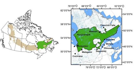
Source: Environnement Canada, 2012, page 149
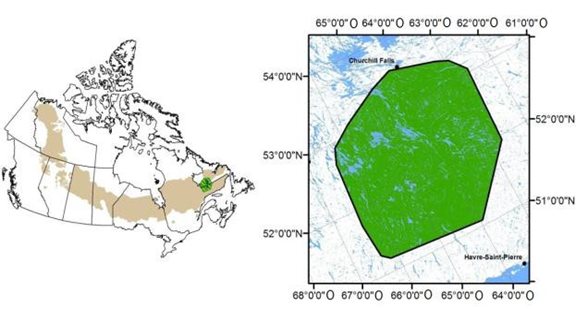
Source: Environnement Canada, 2012, page 150
The proponent profiled boreal caribou using aerial inventory data from the Canadian National company (conducted in March 2012), telemetry data (completed in March 2015) from the Ministère des Forêts, de la Faune et des Parcs as well as reported observations. According to the survey conducted for Canadian National, two groups of boreal caribou were observed south of the Rivière aux Pékans (linkings 483+700 and 494+000). According to the proponent, the absence of observations between the Pékans River and Lac de La Rue and the north of the study area is possibly related to the presence of a large burn in this area, to anthropogenic disturbances. (e.g. Mount Wright Mine, Town of Fermont, Resort) and the presence of quad and snowmobile trails.
The telemetry-based monitoring program by the Ministère des Forêts, de la Faune et des Parcs begun in March 2015 with 12 radio-collared boreal caribous from the Petit lac Manicouagan herd. Of these, two individuals frequented the study area. Based on these preliminary data, the proponent concludes show that the most commonly used areas are those of Midway Lake and Jonquet Lake. Finally, observations reported by the Ministère des Forêts, de la Faune et des Parcs mention a group of 25 caribou observed to the south of Luck Lake in March 2014.
Based on the information in Appendix H-4d (Table 9) of the Boreal Caribou Recovery Strategy (Environment Canada, 2012), the proponent mapped habitats with the biophysical characteristics required by caribou for its vital processes. The proponent provided a mapping of potential habitats for calving, post-calving, rutting and wintering (Figure 13, 14, 15, 16, Table 10).
|
Type of habitat |
Description |
|---|---|
|
Source: Environment Canada, 2012. pages 94-95 |
|
|
Large scale |
|
|
Calving |
|
|
Post-calving |
|
|
Rutting |
|
|
Winter |
|
|
Travel |
|
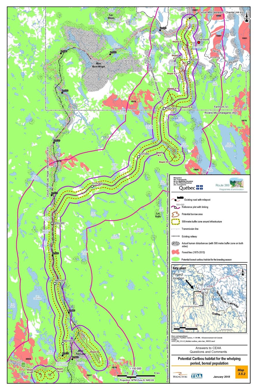
Source: MTMDET, 2018. page 29
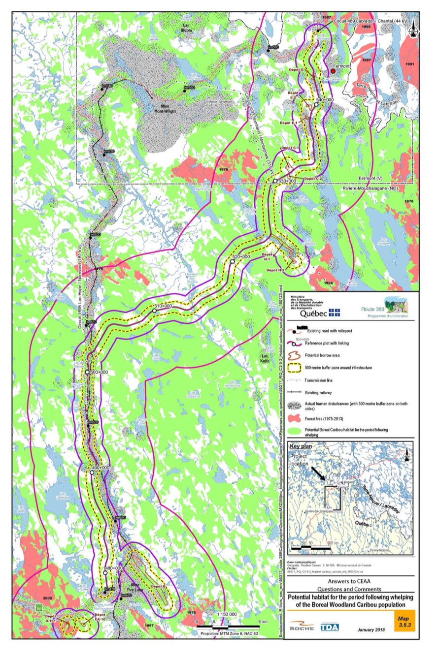
Source: MTMDET, 2018. page 31
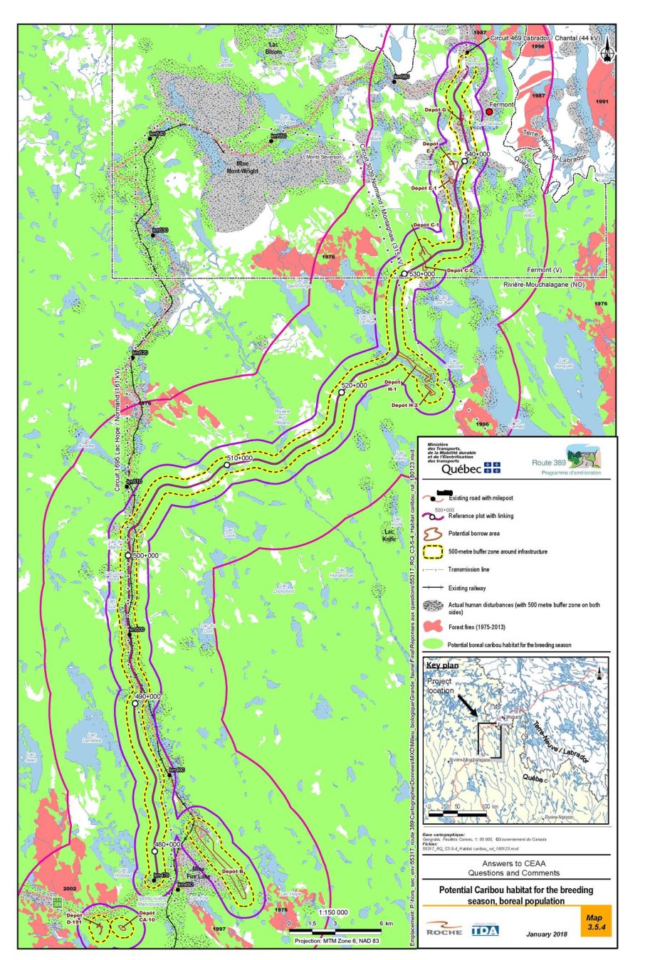
Source: MTMDET, 2018. page 33
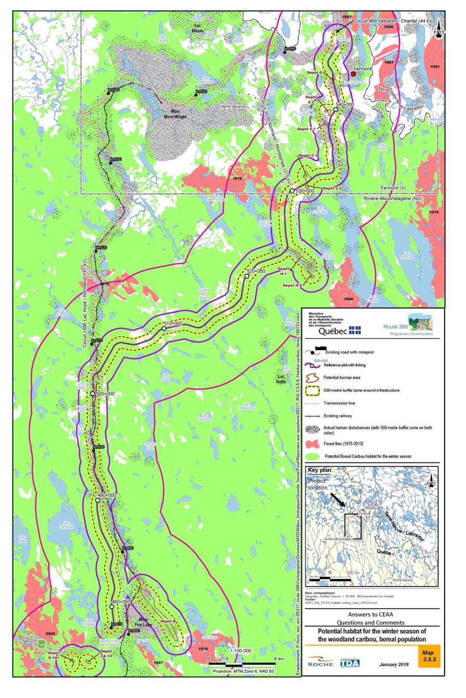
Source: MTMDET, 2018. page 35
Migratory caribou, Eastern population
In May 2017, the Committee on the Status of Endangered Wildlife in Canada recommended endangered status for the migratory caribou, eastern population. The designation process is ongoing. This population has no legal status at this time. This population has no legal protection status at this time.
Migratory caribou populations are known to go through natural cycles with high and low numbers of animals in the herd (Couturier et al., 2004). The proponent indicates that migratory caribou, the eastern population, have historically used the study area. However, due to its current decline, this species has not been in the project area since the 2000s. In recent years, migratory caribou herds have been located more than 220 km north of the project area.
Bats with precarious status
Based on data from the Réseau québécois d'inventaires acoustiques de chauves-souris (CHIROPS, 2011) and the Centre du patrimoine naturel du Québec, five bat species are likely to use the study area: Little Brown Myotis, Northern Myotis, Silver-haired Bat, Eastern Red Bat and Hoary Bat.
The Little Brown Bat and the Northern Bat are endangered species listed as Endangered under the Species at Risk Act. The Eastern Red Bat, Silver-haired Bat and Hoary Bat are likely to be designated threatened or vulnerable in Quebec.
The Little Brown Bat and the Little Northern Bat are resident, that is, they spend the winter in Quebec and gather in hibernacula, which are generally underground habitats like caverns or disused mines. These two species are greatly affected by the white-nose syndrome, which would have led to a drastic fall in the numbers of their population. It is an infection caused by a pathogenic fungus, often characterized by the appearance of a furry white deposit nn the bats' noses, which affects the tissues and muscles and decreases the immune functions of infected individuals often causing their death.
For the Eastern Red Bat, Silver-haired Bat and Hoary Bat, these species are migratory, that is, they migrate to the southern United States and the Caribbean during the cold season. They are present at northern latitudes during the summer season (MDDEFP, 2013c). These migratory species may end up in the study area, but according to the proponent, the potential to find these species would be very low in north of the 52nd parallel. It is therefore unlikely to find these species in the study area.
The study area is at the northern limit of the known range of the little brown myotis and the northern myotis (COSEWIC, 2013; Prescott and Richard, 2004). No bat-specific inventory has been conducted by the proponent. According to the proponent, the Little Brown Myotis and the Northern Myotis could be present in the study area during migration and the breeding period in all forest stands (particularly old forests not recently affected by fire, which is the case for the forests in the study area), particularly near watercourses and wetlands. Bats are also likely to establish in trees that can be used as maternity roosts (typically large decomposing trees with cavities near waterbodies) as well as in rock crevices and in the built environment. Searches carried out indicate that no special habitat such as a decommissioned mine, cave or large cliff area exists in the vicinity of the project. There are some cottages in the study area which could provide habitat for bats.
Based on the information contained in the proposed Recovery Strategy for the Little Myotis (Myotis lucifugus), Northern Myotis (Myotis septentrionalis) and Eastern Pipistrelle (Perimyotis subflavus) in Canada (Environment Canada, 2015b), the potential for natural and man-made structures (caverns, caves, crevices, abandoned mines, hollow trees, bridges, buildings, etc.) to be found in the study area that can serve as hibernacula or maternity was analyzed by the promoter. No hibernacula are currently known in or near the study area (Gauthier et al. 1995). According to Gauthier et al. (1995), disused mines likely to constitute a hibernaculum of interest to bats located closest to the study area are more likely to be located in the Gaspésie-Îles-de-la-Madeleine region, which is several hundred kilometres from the study area. The proponent noted that the possibility of finding hibernacula in the study area cannot be ruled out, but that it is unlikely that decommissioned mines or natural caves suitable for hibernation are present in the study area. Some cottages are located in the study area and could be used as habitat for bats.
The recovery strategy published by Environment and Climate Change Canada in 2015 partially identifies the critical habitat of these species, specifically some known hibernaculas in the Eastern Townships, Nord-du-Québec, Outaouais and Estrie; however, no hibernacula were identified in the North Shore region where the project is located.
Finally, the proponent produced a map (Figure 17) that identifies areas of potential greater potential for Little Brown Bats and Northern Bats during migration, breeding, and wintering seasons based on information available in the literature. The proponent notes that this map demonstrates that forest stands are common habitats in the study area and that fires under 70 years old are virtually absent. The abundance of rivers and lakes would confirm the potential of these habitats for the feeding and movement of forest bats. There are few areas with rocky outcrops.
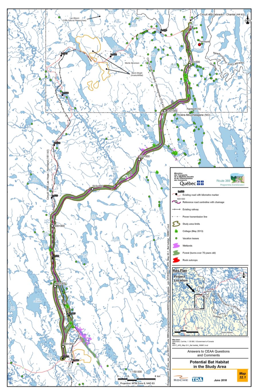
Source: MTMDET, 2016, page 159.
6.5.2 Proponent's assessment of environmental effects
According to the proponent, the project could have an adverse impact on terrestrial mammals associated with habitat loss and disturbance, disturbance of wildlife and risk of mortality; however, the residual adverse effects on mammals would not be significant.
The proponent is of the view that the magnitude of the effects would be low since all terrestrial mammal populations could move to similar habitats in the surrounding area. Furthermore, their abundance and distribution would be modified slightly and temporarily, but this would not compromise their integrity. The project should not affect the stability of bat with precarious status populations, taking into consideration the absence of known critical habitats (hibernaculum, maternity roost), the low density of roads in the region and the low level of traffic expected. With regard to the Boreal Caribou, the effect is considered low since the level of critical habitat disturbance will increase by only 0.9% in an area of 40 km around the road and its right-of-way. The total disturbance rate will remain within the 35% disturbance threshold, as defined in the recovery strategy.
Anticipated effects on micromammals with precarious status
A rock vole, a species likely to be designated threatened or vulnerable, was captured 700 m from the proposed right-of-way in September 2013. A second species likely to be designated threatened or vulnerable is the Southern Bog Lemming, which is also likely to be observed in the study area, according to the proponent.
The main effects of the project on micromammals would include loss of terrestrial and wetland habitats, habitat alteration, disturbance and an increased mortality risk. Forest clearing, construction activities of the road and operation of borrow pits would result in the permanent loss of 11.75 ha of wetlands used by those species.
According to the proponent, all of these impacts would not threaten the stability of micromammal populations throughout the study area due to the abundance of habitats of interest on the periphery of the areas affected by the project.
The proponent also indicates that during operation, given the general integrity of the surrounding habitats, the anticipated road traffic and the width of the road right-of-way, the proposed road would be permeable to the movement of micromammals.
The road would increase the risk of collision and mortality. However, in view of the fact that micromammals tend to avoid roads or cross them quickly no specific mitigation measures are considered necessary to reduce mortality risks.
Anticipated effects on small mammals
According to the proponent, forest clearing, construction activities and operation of borrow pits would result in the loss or disturbance of 451.57 ha of forest stands, 12.56 ha of wetlands and 1.41 ha of dry, bare areas. In the right-of-way, new vegetation of the "dry, bare" type on either side of the roadbed will be suitable for open habitat species and ubiquitous species such as Red Fox, Long-tailed Weasel, Ermine, Gray Wolf, Striped Skunk (Prescott et Richard, 1996; Feldhamer et al., 2003).
Construction activities could disturb small mammals, especially species with a small home range. The proponent mentions that efforts by herbivores such as the American Porcupine, Woodchuck, and Snowshoe Hare to move to a safe environment could alter their physical condition or increase their vulnerability to predation. According to the proponent, these temporary effects would nonetheless cease on completion of the construction work.
Construction activities and vehicle traffic during operations would also increase the risk of mortality, particularly for species associated with trees and for the young of most species, which are confined to nests or burrows for several weeks until they can move around on their own. Waste management sites, feeding by workers and food odours could attract certain animals (e.g. gray wolf, red fox), resulting in their displacement or mortality.
According to the proponent, all of these effects would not threaten the stability of populations of fur-bearing animals at the scale of the study area, given the abundance of favourable habitat available on the periphery of the affected zones and the high rates of reproduction found in the majority of these species.
During the operation phase, the presence of the road and its use could likely alter habitat quality and increase the risk of collision-related mortality for small mammals. With regard to avoidance of roads and habitat fragmentation, the planned road is not expected to act as an impermeable barrier to the movement of small mammals but rather as a filter that limits exchanges.
Finally, the presence of a new section would increase access to this territory. This would create a new access for hunting and trapping these animals for food, social or ceremonial purposes. This new route would facilitate the movement of hunters and trappers through the use of vehicles, quads or snowmobiles. Local populations of species that are prized by trappers, specifically the Marten, the Canadian Beaver and the Red Fox, could thus experience a decline owing to the increased access (Hogman et al., 1994). However, it is not possible for the proponent to determine the intensity of the effect of this increase in harvest as current trapping data are not available. However, the proponent specifies that for trapping and poaching to have a significant and persistent negative impact, that is to say, it exceeds the population's sustaining capacity, a high and widespread harvesting pressure would be required at a regional scale. According to the proponent, it is unlikely to happen because of the small number of trappers (compared to the size of the territory) and the fur market which is currently stagnant.
Anticipated effects on large mammals (except for Boreal Caribou)
The main anticipated effects on large mammals include the loss and degradation of terrestrial and wetland habitats, disturbance, risk of collision and increased hunting pressure.
Loss and disturbance of habitat
Forest clearing activities and other construction activities would cause a permanent loss of terrestrial habitat for moose, black bears and woodland caribou. The habitat losses will amount to 202 ha to 221 ha for the road right-of-way and 462.3 ha to 487.2 ha.
Disturbance
Noise from construction activities could disturb large mammals near the work areas and interfere with their foraging, breeding and rearing behaviour, especially in winter when travel is more difficult.
Disturbance to black bears could occur during the hibernation period; however, few bears should be affected, given the low density of bears in the study area and the fairly narrow road right-of-way.
During the road operation phase, avoidance behaviour of the black bear and moose could result in loss of functional habitat. Habitat alteration and fragmentation of habitat into less favourable habitats would accentuate this avoidance behaviour. However, given the low density of these species in the study area and the limited traffic volume that is expected, the road should not act as a barrier to displacement and the impact would be limited.
Hunting and predation
Workers involved in the construction work could cause a slight increase in moose hunting pressure. However, the proponent considers that this pressure would be low given the level of preparation required and the short time usually available to workers for this type of activity. Hunting pressure on black bears should not increase given the low harvesting rate in the region (Lamontagne et al., 2006; Lefort and Massé, 2015). Sport hunting of woodland caribou was prohibited in hunting area 19 in 2001.
During the operational phase, the modification of the Route 389 route would create 45 km of new road in a territory that is currently under-frequented. This would create access to new, more easily accessible areas for hunting and trapping. This accessibility may increase the likelihood of a local decline in moose populations. Finally, the temporary camps and landfills that would be present during the construction phase, as well as the potential increase in the number of cottages in the mining phase, may attract some individuals and cause displacement or slaughter of unwelcomed animals.
Collision mortality
The number of collisions with large mammals on the new road could increase, thus increasing their mortality rate. However, the improved visibility due to better road design should help to reduce this risk.
Anticipated effects on Boreal Caribou
Loss and disturbance of habitat
For the QC-6 range, the proponent used data from the Programme d'inventaire écoforestier nordique (sheet 23B) to map boreal caribou habitat in the extended footprint of the road on over 361,500 ha. Direct losses were defined by the route of the road, its right-of-way, the borrow pits and to which a 500 m influence zone was added, in accordance with the Woodland Caribou Recovery Strategy (Environment Canada 2012) and the Report on the Progress of Recovery Strategy Implementation for the Woodland Caribou (ECCC, 2017). Thus, the total area of the project footprint would total 9,244 ha, while the road right-of-way and borrow pits alone would total 494 ha.
Considering the characteristics of the various components of critical habitat described in the Recovery Strategy (Environment Canada, 2012), the roadway footprint would result in direct losses of 7,479 ha of potential habitat during calving, 4,596 ha of potential habitat during the post-calving period, 7,543 ha of potential habitat during rut period, and 7,842 ha of potential habitat during wintering. The proponent points out that the same type of natural environment can be used for several habitat functions, so the footprint of the road results in 7,961 ha of direct loss of natural environment. Table 11 presents the result of the evaluation and the calculation done by the proponent. Proportionately, it would be the post-calving and calving habitat that would affected by the project.
These losses of critical habitat would have direct impacts on the caribou, including the loss of food sources, but also several functional losses for this species, which is sensitive to disturbance and fragmentation of its habitat. In addition, the impacts of roads on caribou appear to be greater at certain times of the year. According to the proponent, calving is a critical period in the annual life cycle of the species during which the response to the presence of roads could be exacerbated. A description of the effects of these habitat losses is summarized in Table 12.
|
Natural habitats |
Calving |
Post-calving |
Rutting |
Winter |
Direct loss |
Zone of influence |
Avoidance zone |
|---|---|---|---|---|---|---|---|
|
Source: MTMDET, 2018, page 40 |
|||||||
|
Tall shrubland |
X |
X |
X |
47 |
82 |
96 |
|
|
Burns |
- | - |
X |
X |
66 |
288 |
6 968 |
|
Water |
- | - | - |
X |
417 |
1,459 |
10,769 |
|
Barrens/lichen stands |
X |
X |
X |
X |
932 |
1,626 |
3,507 |
|
Islands |
X |
X |
- | - |
2 |
6 |
37 |
|
Conifers with lichens (mature; > 40 years) |
X |
- |
X |
X |
2,856 |
6,828 |
23,805 |
|
Conifers with lichens (regeneration; < 40 years) |
X |
- |
X |
- |
27 |
90 |
121 |
|
Conifers with lichens and mosses |
X |
X |
X |
X |
16 |
16 |
35 |
|
Conifers with mosses, sphagnum and ericaceous species (mature; > 40 years) |
X |
X |
X |
X |
3,520 |
8,836 |
41,279 |
|
Conifers with mosses, sphagnum and ericaceous species (regeneration; < 40 years) |
X |
X |
X |
44 |
158 |
1,175 |
|
|
Peatland |
X |
X |
X |
X |
34 |
104 |
427 |
|
Total habitat (1.25 km) (ha) |
17,746 |
10,828 |
17,658 |
19,157 |
- |
19,493 |
- |
|
Total habitat (5 km) (ha) |
70,482 |
46,556 |
77,413 |
86,790 |
- |
- |
88 219 |
|
Total habitat (500 m) (ha) |
7,479 |
4,596 |
7,543 |
7,842 |
7,961 |
- |
- |
|
Natural habitats not suitable as woodland caribou habitat (deciduous and mixed stands) |
- | - | - | - |
1,016 |
2,666 |
7,411 |
|
Human-modified |
- | - | - | - |
267 |
578 |
1,089 |
|
Total (ha) |
- |
- |
- |
- |
9,244 |
22,737 |
96,719 |
|
Habitat type |
Area disturbed by the footprint |
Anticipated effects of direct habitat loss |
|
|---|---|---|---|
|
On the dynamics of the population |
Common |
||
|
Calving |
7,479 |
Modification of the annual recruitment rate. Loss of fidelity to home range sites. |
Increased travel to meet vital needs. Increased vulnerability to predators. Modification of behavioral responses (vigilance, avoidance, flight). Loss of access to food resources (lichen). Isolation of individuals (loss of genetic diversity). |
|
Post-calving |
4,596 |
Modification of the survival rate of the fawns. |
|
|
Rutting |
7,543 |
Modification of the energy budget. Modification of the reproductive success. |
|
|
Winter |
7,842 |
Increased competition for food resources. Modification of the survival rate of adults. |
|
The proponent has demonstrated that the residual effects of the project would not be inconsistent with the efforts of the province to achieve the objectives of the Boreal Caribou Recovery Strategy (Environment Canada, 2012; ECCC, 2017), the primary goal of which is to ensure self-sufficiency of local populations by maintaining 65% of undisturbed habitat within the range. At this time, the population in the QC-6 range is assessed as self-sustaining with 32% of disturbed habitat (ECCC, 2017). The project must not increase this rate beyond the critical threshold of 35%.
To achieve this, the proponent assessed the disturbance rate of the project to a study area corresponding to a 40 km buffer zone on either side of the road (1,004,000 ha). This zone was established following recommendations from the Ministère des Forêts, de la Faune et des Parcs' Recovery Team. This area corresponds to a portion of the landscape in which the caribou can live. It has therefore been estimated that existing disturbances (human activities and fires under 40 years old) currently affect 22.4% of the total area of the study area.
The rate of disturbance induced by the direct losses (road footprint and 500 m on each side) (9,244 ha) calculated by the proponent would be 0.9%. The proponent also calculated a rate of 0.8% if only caribou habitats (7,961 ha) are considered.
Thus, by adding these disturbance rates to those already present (22.4%), the total disturbance rate (current and project of Route 389) would be 23.3% for the entire study area (part of the landscape in which caribou can live) or 23.2% if only suitable habitats are considered. The total rate would therefore remain below the 35% management threshold established by Environment and Climate Change Canada in the recovery strategy for Quebec's woodland caribou (Environment Canada, 2012).
Fragmentation of the natural environment would also affect caribou habitat by creating a boundary through a linear anthropogenic feature. Recognizing that geographic isolation by a border effect is a factor limiting the growth of Boreal Caribou, the proponent considers that the construction of the road would have a direct effect on the needs of large areas of non-fragmented caribou habitat.
However, the proponent also assessed the effects of the project on connectivity within the QC-6 range as well as between the QC-6 and NL-1 ranges, and in his view the anthropogenic presence and the current road would not create geographically isolated habitats. For example, it considers that movement to large areas of habitat within the QC-6 area would still be possible. With respect to the connectivity between the QC-6 and NL-1 areas, the proponent is of the opinion that, in the long term, during the operation phase, the road would not prevent connectivity between the populations of the two QC-6 and NL-1 areas. In fact, despite the road that acts as a semi-permeable barrier to caribou movement, the many protected areas (official or projected) would maintain sufficient forest to allow a flow between the two ranges.
Disturbance
Boreal caribou are particularly susceptible to disturbance and may avoid the work area during the construction period. Calving (in the spring) would also be a critical period in the annual life cycle of the species during which caribou would be more susceptible to disturbance (Leblond et al. 2012).
The presence of the road during the operation phase would also have indirect effects on caribou due to disturbance. The proponent conducted an analysis using the Programme d'inventaire écoforestier nordique (minimum 8 ha) mapping data that estimated the area of indirect effects in natural environments corresponding to boreal caribou habitat (Table 10).
The proponent carried out this analysis according to two areas of influence: 1.25 km and 5 km. According to his analysis, it would be mainly winter habitat that would be most affected in the two zones of influence. Then, within a radius of 1.25 km, the calving habitat would be the most affected, while in the 5 km zone it would be rather the rutting habitat.
Disruption due to the presence of the road could imply the same compromises for an animal as the risk of predation (Frid and Dill, 2002) and thus provoke the adoption of anti-predictive strategies such as vigilance, avoidance and flight. This change in behavior may interfere with other important activities such as feeding and reproduction. The preference for habitats remote from linear infrastructures could also induce a form of intraspecific competition.
Hunting and predation
For Boreal Caribou, although its sport hunting has been banned in the south hunting zone 19 since 2001, the species could be affected by increased predation and poaching for food, ritual or social purposes.
In terms of predation, deforestation during road construction would lead to regeneration conditions with a fairly rejuvenated plant facies that would attract moose populations in search of deciduous food. This increased presence of moose could then attract the gray wolf, which would exert opportunistic and consistent predatory pressure on the caribou. Regeneration following deforestation would also be composed of fruit trees and shrubs that would attract the black bear, which is an important predator of ungulate fawns. According to the proponent, predation appears to be an important limiting factor for caribou populations in boreal forests and its effect could be amplified by forest management.
Anticipated effects on bats with precarious status
The anticipated effects during the construction phase are direct losses of terrestrial and wetland habitats, disturbance due to construction activities, mortality caused by vehicle traffic, and potential destruction of maternity roosts or hibernacula.
Forest clearing and other construction activities such as the operation of borrow pits could reduce the quantity of habitat available in 45.6 ha of forest stands as well as in 12.56 ha of wetlands. These losses represent 10.59% of forest stands and 5.35% of wetlands in the study area. The losses would be fairly small taking into account the total quantity of habitat available in the study area.
Bats are generally sensitive to disturbance. Construction of the road would involve nighttime activities of medium (brush removal, repair of a portion of road, etc.) to high (forest clearing, blasting) intensity on short stretches of road at a time, over a period of four years. No critical (hibernaculum, maternity) or rare habitats have been identified so far and the likelihood of finding these habitats is fairly low in the study area.
In the operation phase, the presence of new road sections would modify the available habitats and "dry, bare" vegetation would colonize the new road segments. Migratory species (Eastern Red Bat and Hoary Bat) are recognized as open habitat species. According to the proponent, resident species (Little Brown Myotis and Northern Myotis) are forest species that prefer to commute under forest cover; they may have a tendency to avoid the environment created by the project.
It is difficult for the proponent to estimate the number of collisions and the mortality that could result from the project since we have no information on the density of local bat populations or their distribution. Resident forest species (Little Brown Myotis and Northern Myotis) that fly at a lower level than migratory species (eastern red bat and hoary bat) would likely be at greater risk. In addition, the risk would probably be higher during the breeding/migration period and in locations where the road crosses watercourses since these are habitats used preferentially by bats for commuting.
6.5.3 Mitigation, monitoring and follow-up measures
The proponent identified a number of measures for mitigating the effects of the project on each group of terrestrial mammals (see Appendix B). They are aimed at reducing habitat loss by reducing deforested or disturbed areas, routing traffic through specific corridors, avoiding certain sensitive environments and revegetating bare areas following the works. Specific measures will be put in place to reduce the effects of the project on boreal caribou and bats with precarious status.
Here are examples of measures proposed by the proponent for terrestrial mammals species collectively:
- Limit deforestation exclusively to the necessary areas and where possible, maintain a protective cover by partial cutting to limit the impact of deforestation and habitat fragmentation.
- Close temporary access roads of all kinds after use to limit the accessibility and inconvenience of wildlife, including Boreal Caribou.
- Cut vegetation in road curves so that drivers of vehicles can clearly see animals crossing or about to cross the road. This measure is intended to reduce the frequency of road collisions.
- ? Raise awareness among construction workers, through posters and information sessions, of the importance of not feeding animals and not leaving food that would attract animals near camps. In cases where bears should be slaughtered, allow the tallymen to hunt these bears themselves.
- Raise awareness of the public and Aboriginal people about the effects of harvesting, poaching, accidental kills and disturbance of woodland caribou.
Measures Specific to Boreal Caribou (Threatened status under the Species at Risk Act):
- If a caribou calving area is identified (in collaboration with the Ministère des Forêts, de la Faune et des Parcs) south of the Pékans River (particularly between the 502 + 000 and 513 + 000 linkages of the new road) or if a calving area near the study area is identified, avoid construction within 10 km of the area between mid-May and late July.
- Restore borrow pits, temporary access roads, sections of the old road and temporary work areas. Implement measures to limit nesting and contribute to the rehabilitation of Boreal Caribou habitat conditions by planting resinous species representative of the native species of the environment.
- Raise awareness of the public and Aboriginal people about the effects of harvesting, poaching, accidental kills and disturbance of woodland caribou during all phases of the project.
- If caribou are observed near the work areas during the construction phase, immediate measures will be put in place to limit the risk of disturbance, until the risk is completely eliminated. The sequence of tasks to be performed by the workers or subcontractors would be:
- ? Interrupt work within 1,000 metres of the individual (s) up to 30 minutes after departure, or until intervention by the Ministère des Forêts, de la Faune et des Parcs, if necessary;
- ? Advise the environment manager of the site monitoring and the Ministère des Forêts, de la Faune et des Parcs of the observation in question (location, number of individuals, habitat, behavior and any other relevant information);
- ? Stay in constant communication with the Ministère des Forêts, de la Faune et des Parcs to inform them of the evolution of the situation and to receive instructions to follow if necessary;
- ? Complete the distributed wildlife observation form and submit it to the environment manager.
Measures specific to Little Brown Bats and Northern Bats (Endangered status under the Species at Risk Act):
- Validate the presence of structures potentially suitable for hibernation or reproduction of these species before the start of work. If necessary, carry out an inventory of bats to confirm their presence. In the event of the discovery of a hibernacula, a maternity colony or resting sites for males, the following actions would be taken:
- ? Inform the Ministère des Forêts, de la Faune et des Parcs and Environment and Climate Change Canada of the position of the hibernacula, maternity colony or resting site for males and work to be carried out nearby (in a radius of 500 metres);
- ? Establish a protection zone with a radius of 500 metres for a maternity ward and one kilometre for a hibernacle;
- ? Move, at the appropriate time, the buildings housing a colony or a maternity home located in the right-of-way of work according to the protocol presented in MTMDETQ (2018). If the move is not possible, provide alternative infrastructure (appropriate and existing anthropogenic structures or artificial dormitories);
- ? Take the necessary precautions to reduce the risk of spreading white-nose syndrome if you have to come into contact with bats.
- Maintain a cutting yard distance greater than 50 metres from a maternity ward.
- If compatible with the safety of road users, install asymmetrical (or equivalent) spotlighting with low lumen.
- Near a maternity ward (up to 350 metres): Favor high or low pressure sodium lamps, emitting a yellow light. Artificial lighting should be oriented horizontally so that no light beam should point to a maternity ward. During the operation of the road, measures must be taken to limit the noise generated by machinery when activities construction will be carried out nearby (ie, up to 350 metres) from the maternity ward. A threshold of sound below 80 dBA perceptible at the breeding site could be applied as a precautionary principle in the case of a maternity of bats.
Monitoring and follow-up
The proponent indicates that it intends to implement a monitoring program during the construction phase to ensure the application of mitigation measures and the specific requirements of government authorities, as appropriate. These measures would be incorporated into plans and specifications in order to be known and applied by the contractors who will carry out the work. The monitoring program would target large wildlife, including Boreal Caribou and bats at risk. Mitigation measures for species at risk, including Boreal Caribou, will be subject to special and ongoing monitoring. Adaptive management measures will be put in place as needed if the planned measures are not effective or adverse effects are observed.
For large wildlife, the proponent also proposed:
- In collaboration with the Ministère des Forêts, de la Faune et des Parcs, document the presence of Boreal Caribou and other large wildlife species that are observed during the construction phase. This information would be compiled in a register of wildlife observations. They would then be used to assess the effectiveness of the mitigation measures put in place and to determine if additional measures are needed.
- Document the presence of nuisance animals (black bear, moose, wolf, etc.) on site of Route 389 project A and evaluate the effectiveness of mitigation measures implemented for avoiding their presence. If necessary, put additional measures to reduce the risk.
For bats, the monitoring program would validate the presence of structures potentially suitable for hibernation or reproduction and validate the presence of bats. These validations would be carried out upstream of the works and carried out according to the protocol proposed in MTMDETQ (2018). In the event that a hibernacula or a maternity hospital is discovered, measures would be put in place to protect them (protection zone), to move the buildings housing these settlements or maternity (if present in the project area) or to provide alternative infrastructure.
The follow-up program would consist of verifying the accuracy of the environmental assessment and determining the effectiveness of the measures that would be implemented to mitigate the adverse environmental effects of the project on large wildlife, woodland caribou and bats at risk.
For large wildlife including boreal caribou, the proponent proposes to:
- Document the presence of large wildlife (including Boreal Caribou) all along Highway 389.
- Document the presence of unwelcome animals (black bear, moose, wolf, etc.) and Boreal Caribou along the Route 389 project.
- Document road accidents (over ten years) involving large wildlife.
This information would be compiled in a register of wildlife observations. They would then be used to continuously evaluate the effectiveness of the measures implemented on Route 389, in particular to reduce the risk of accidents.
Specifically for Boreal Caribou, and following discussions with the Ministère des Forêts, de la Faune et des Parcs and their approval, the proponent would carry out a follow-up program that would be based on the telemetry data collected by this ministry as part of their monitoring of Boreal Caribou populations on the North Shore. This monitoring would aim to document the evolution of the population that crosses the study area. These data would be used to determine the location of caribou (large scale) compared to baseline (winter 2018) for the next 10 years (covering four years of the construction phase and six years of exploitation).
Thus, every two years, the proponent would compile and analyze telemetry data, including those from the wildlife and accident observation log, reported along the section of the road to determine the need to put in place measures to reduce impacts. One of these measures could be, for example, the establishment of road signs on the road. The choice and the need to put in place a measure would be done in collaboration with the Ministère des Forêts, de la Faune et des Parcs.
For bats with precarious status, a monitoring program for maternities or bat colonies would be carried out in the case where:
- A building containing a maternity ward or a bat colony was moved.
- Bat shelters were set up to replace a building that housed a colony or maternity ward and was destroyed.
To do this, an inventory will be carried out annually (twice a year for a minimum of five years) of the structures moved or managed to verify the effectiveness of these and document their use according to the protocol presented in MTMDETQ (2018). The proponent would also use an ultrasound detector to validate the species of bat that uses the infrastructure. Corrective measures would be made if the structures were not used or deserted (MTMDETQ, 2018). If necessary, a follow-up of 5 years would be carried out following the intervention to check the effectiveness.
6.5.4 Comments received
Federal authorities
Environment and Climate Change Canada is satisfied with the description of critical habitat and habitat with the biophysical attributes required by Boreal Caribou to accomplish these vital processes. Environment and Climate Change Canada is also satisfied with the assessment of the effects of the project on caribou and their habitat. The identification and description of the effects potentially induced by the project are considered to be complete and consistent with the identified threats in the recovery strategy (Environment Canada, 2012).
Based on the information provided by the proponent and given the amount of habitat that would be disturbed by the project compared to the entire QC-6 range, Environment and Climate Change Canada considers the project to be unlikely to contribute to adverse range effects. It would also be unlikely that the project would result in the loss of a significant proportion of habitats with the biophysical characteristics required for caribou to complete their life processes.
Finally, Environment and Climate Change Canada is of the view that, if all of the proponent's proposed mitigation measures are implemented in a timely manner, the effects of the project on boreal caribou would be minimized.
With respect to bats at risk (Little Brown Bats and Northern Bats), Environment and Climate Change Canada is satisfied with the analysis of the effects of the project on these species and their habitat. According to Environment and Climate Change Canada, the analysis would be complete and consistent with the threats identified in the proposed recovery strategy (Environment Canada, 2015b).
Although the proponent considers that there is a low potential for finding structures that shelter bats in winter or during breeding periods, Environment and Climate Change Canada considers that field verification is necessary to validate the presence of potential structures for hibernation or reproduction of bats before construction begins. Environment and Climate Change Canada is therefore satisfied with the proponent's commitment to implement a specific monitoring and follow-up program for bats at risk during the project and its commitment to put in place corrective measures in the event that the monitoring program demonstrates that the objectives have not been achieved. Thus, the project would not be likely to go against the measures identified in the recovery strategy proposal.
Federal authorities
The Ministère des Forêts, de la Faune et des Parcs would not consider other moose management measures (to reduce the effects of wolf predation on caribou) other than the current hunting arrangements as these are permissive, the length of the hunting season for moose to the gun is four weeks and that harvesting of all segments of the population is allowed each year. The Ministère des Forêts, de la Faune et des Parcs considers that habitat quality for Boreal Caribou in this area, caribou population status, and low moose abundance do not warrant additional measures for moose management. Instead, they recommend that control measures be implemented by the proponent by reforestation of access roads and borrow pits.
The Ministère des Forêts, de la Faune et des Parcs is of the opinion that the mitigation measure to avoid construction work within a 10 km radius of an identified calving site is of interest to reduce the effects of the project on Boreal Caribou during a period when it is particularly vulnerable to disturbance and predation.
According to the Ministère des Forêts, de la Faune et des Parcs, the probability of Boreal Caribou persistence is currently higher than 60% in more than 80% of the area covered by the provincial recovery plan in the North Shore region. The construction of a new 56-kilometres road within area covered by the provincial woodland caribou recovery plan will have little effect on the level of habitat disturbance. To date, the level of habitat disturbance has proven to be the most robust indicator of the probability of persistence of a boreal caribou population. However, according to the Ministère des Forêts, de la Faune et des Parcs, the effect of the new road on the likelihood that Boreal Caribou hunting will be carried out is a risk that should not be overlooked, although it is difficult to measure.
First Nations
The Innu First Nations have expressed concern that the caribou, moose and bear populations were underestimated by the proponent because it used data from a survey conducted for Canadian National. These data are from 2012 and do not cover the same study area as the project.
The Matimekush Lac-John Innu First Nation mentions that the area around Fermont is a place where both their members and those of the Uashat mak Mani-Utenam Innu First Nation hunt for caribou. In addition, other Innu Nations on the Lower North Shore used to hunt caribou in the Fermont region and this practice could start up again if the caribou return in large enough numbers.
With regard to the study area used to assess the project's effects on woodland caribou, the Innu First Nations are of the view that it would have been better to use a radius of 137 km, as is the case in the impact statement for the Bloom Lake project. They indicate that the 40-km radius used by the proponent is minimal, given the caribou's very large range, and given that Route 389 is only one of many projects implemented in the asserted traditional territory of the Innu (the Nitassinan) which have fragmented caribou habitat. With respect to the temporal boundaries, the First Nations are of the view that a period of 20 years in the future is too short, taking into consideration that caribou are sensitive to disturbance.
General public
No comments were received from the general public regarding the project's effects on terrestrial mammals and their habitat.
6.5.5 Agency's analysis and conclusions
The Agency is of the view that the project is not likely to cause significant adverse environmental effects on terrestrial mammals and its habitat, taking into account the application of the proposed mitigation measures and monitoring and follow-up program.
The Agency notes that the project would cause direct encroachment on about 600 ha of habitat used to varying degrees by mammals (other than Boreal Caribou). Taking into account the 500-m buffer zone around encroachments, the loss of Boreal Caribou habitat would amount to approximately 9,244 ha.
Given the availability of similar habitats for a number of these species in study area, the mobility of the majority of species and the application of mitigation measures and monitoring and follow-up programs, the Agency is of the view that the stability of terrestrial mammal populations would not be threatened by the implementation of the project and the associated habitat losses. In the case of species with limited mobility such as the Rock Vole, the Agency is of the view that the project could lead to the loss of several individuals, without compromising the stability of the population.
With regard to the Boreal Caribou specifically, the Agency agrees with Environment and Climate Change Canada and the Ministère des Forêts, de la Faune et des Parcs that the predicted 0.9% increase in the habitat disturbance level associated with this project in the study area of 40 km radius around the road and its footprint appears low at the regional scale for the entire Quebec range (QC-6).It is unlikely to compromise the objective of maintaining at least 65% undisturbed habitat in this range.
The Agency recognizes that noise and vibrations generated by the project may cause disturbance to terrestrial mammals and could disrupt the foraging, breeding and rearing behaviour of some species. The Agency considers that these noise and vibration disturbance effects would stop after the construction phase and would be limited during the operation phase, taking into account the small number of vehicles expected to use the road.
With regard to collision-related mortality, the Agency is of the view that it is unlikely that collisions on the road would modify the abundance, distribution or stability of local fauna populations, given the low traffic volume that is anticipated and follow-up measures on collisions by large-scale wildlife vehicles (over a 10-year period) and corrective actions that the proponent intends to put in place if necessary.
The Agency is of the opinion that the follow-up measures proposed by the proponent, notably for Boreal Caribou and bats, would make it possible to adapt mitigation measures to limit the effects on these species.
6.6 Current Use of Lands and Resources for Traditional Purposes
This section presents the analysis of the project's effects on the current use of lands and resources for traditional purposes by the Innu First Nations of Uashat mak Mani-Utenam and Matimekush-Lac John, and on structures, sites or things of historical, archeological, paleontological or architectural significance.
The current use of lands and resources for traditional purposes takes into account the practices or activities that are part of the distinctive culture of First Nations and that were commonly practised by this group over a period extending from the recent past to the present or foreseeable in the near future. The current use of lands and resources for traditional purposes includes in particular hunting, fishing, trapping, berry picking, and cultural and other traditional uses of the land (e.g. gathering of medicinal plants, use of sacred sites).
The historical, archaeological, paleontological or architectural significance of a structure, site or thing is determined by the value placed on it. This value originates in particular from its association with one or more important aspects of the history or culture and its association with a particular group's practices, traditions or customs Footnote 27. The analysis deals with material objects, structures and human activities (for example, mounds, culturally modified trees, traditional handicrafts, fossilized remains, historical buildings), sites or places (for example, burial sites, sacred sites, cultural landscapes) and attributes (for example, languages, beliefs).
According to the Agency, a significant residual adverse effect is one that would cause a high degree of disruption to traditional practices or activities by changing the quantity and quality of available resources or access to traditional territory. A significant residual effect would damage large areas of a significant site, compromise the integrity of archeological sites or prevent access to significant sites. The Agency's criteria for evaluating environmental effects and the grid used to determine the significance of the effects are presented in Appendices D and E, respectively..
In the context of this project, the Agency examined the potential effects of the project in a sector on the territory claimed by the Innu First Nations of Uashat mak Mani-Utenam and Matimekush-Lac John. The effects examined are related to access to the territory, availability of the territory and resources, and the structures, sites or things of historical, archeological, paleontological or architectural significance.
Following completion of its analysis and taking into account the implementation of the mitigation measures and the follow-up program proposed by the proponent, the Agency concludes that the project is not likely to cause significant adverse environmental effects on this valued component.
- The construction and operations of the road would result in temporary or permanent changes in access to and use of the traditional territory that can be mitigated without compromising access to the territory.
- The project would not result in a major disruption to the abundance of wildlife and plant resources exploited by First Nations.
- The project would not result in any effects on structures, sites or things of historical, archeological, paleontological or architectural significance.
The following subsections describe the baseline conditions and the essential elements of the proponent's analysis, the opinions of the expert departments and of the First Nations and the public on which the Agency based its conclusions concerning the significance of the project's effects on the current use of lands and resources for traditional purposes by Indigenous peoples and on structures, sites or things of historical, archeological, paleontological or architectural significance.
6.6.1 Baseline conditions
The study area falls entirely within the Saguenay beaver reserve established by the Quebec government in 1954. In the Sept-Îles division of this reserve, the Innu First Nation of Uashat mak Mani-Utenam enjoys special, but not exclusive, rights for the hunting and trapping of fur-bearing animals. The study area intersects three traplines, namely traplines 255, 256 and 243 (Figure 18), in reference to the Saguenay Beaver Reserve, on which the Jourdain and Grégoire families practice traditional activities.
The proponent indicates that it used a number of information sources to establish the baseline conditions of this component, including public documentary sources, documents of the projects dealing with the study area, including the Lower Churchill Hydroelectric Generation Project, the environmental impact statement of the Kami project and the environmental impact statement of the Howse project. The proponent also relied on interviews with the Innu users of the territory, briefs submitted by the First Nations and information gathered during the environmental monitoring and follow-up of the Sainte-Marguerite-3 Hydroelectric Development Project.
According to the information presented by the proponent, the Innu make current use of the lands and the resources that they use for traditional purposes. The annual cycle of territory use extends over the entire year. Generally speaking, the main usage periods are the winter for caribou hunting, May for the spring Canada Goose hunt, September and October for berry picking (blueberries, lingonberries and bake-apples), and December and January when the members of the families gather on the territory to spend the holidays. In addition to the main activities mentioned above, the users engage in fishing, hunting, trapping small game (hare, partridge, porcupine, beaver) and big game (moose, bear, caribou). On the territory, several camps or cottages are also present and used by the Innu as part of their activities. In general, the Innu of both communities enter the territory via Highway 389, secondary roads, quad trails, snowmobile trails and waterways.
According to the information collected, the territorial areas of seasonal use by the Innu of Uashat mak Mani-Utenam are concentrated on traplines 255 and 243, along Route 389, from the area around the Fire Lake mine to the Quebec–Newfoundland and Labrador border.
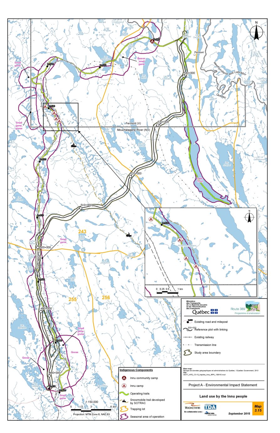
Source: MTMDET, 2015, page 203.
During the group interviews conducted by the proponent in 2014, the Innu holders or main users of the trapping grounds made it clear that, regardless of the specific areas of use already identified or mapped in other studies, they use the entire territory of their respective traplines, moving along and between these traplines wherever the desired resources are found.
With respect specifically to the use of the land and resources by the Innu of Matimekush-Lac John, the following information has been compiled based on consultations conducted by the proponent in February 2017 and a review of the literature:
- The site of the proposed bridge crossing the Pékans River is considered by the elders of that community as a place that is culturally significant and important for hunting and fishing.
- The De La Rue Lake sector is used for hunting Canada geese. It is also a caribou travel corridor.
- A traditional Innu traffic route east of the existing Route 389 served to link the Pékans River to Wabush Lake. This corridor allowed the traditional bands from Kaniapiskau and Ste-Marguerite to meet with the bands from Petiskapau and Moisie via Ashuanipi Lake in Labrador, and vice-versa.
- Use for navigation of the Petite Rivière Manicouagan, the Pékans River, and De La Rue Lake.
Finally, the proponent assessed the archeological potential on the basis of data concerning the locations of known sites, historical data and criteria for assessing Indigenous archeological potential (geography, geology, morpho-sedimentology, hydrography, vegetation, wildlife and access). A total of 77 areas with archaeological potential distributed along the project route were identified in the study area. Of these zones, the eight most likely to be affected by the project were inventoried in accordance with the requirements of Quebec's Cultural Heritage Act in the summer of 2015. After visually inspecting four of these zones and conducting over sixty exploratory surveys without discovering any archeological artifacts or remains, the senior archeologist in charge concluded that the development work planned as part of the project could proceed without consequence to archeological heritage.
6.6.2 Proponent's assessment of the environmental effects
Anticipated effects
According to the proponent, some project activities could generate nuisances such as noise, dust, vibrations and obstacles to movement, that are likely to have impacts on the Innu use of the territory, and more specifically on access to the territory, the area of the territories available for the practice of traditional activities, and the availability of resources (wildlife, plants).
The proponent indicated that the project is not likely to cause significant adverse effects on the current use of lands and resources for traditional purposes or on the archeological sites potentially present in the study area.
Taking into account the implementation of all the planned mitigation measures, the proponent deems that the intensity of the effects would be medium during construction phase and low during operations. The temporary constraints on access to the territory and to resources during the construction phase should not compromise the practice of traditional activities by the Innu.
To determine the intensity of the impact on land use by the Innu, the proponent used these three variables:
- Accessibility of the territory
- Territory available for the practice of traditional activities
- Availability of resources (plants and animals).
Effects on access to the territory
With regard to access to the territory, the proponent used the information from the literature review, information obtained from its meetings with First Nations members, and information provided by the Agency following consultations with the First Nations to determine what impacts the project would have on the Innu's travel corridors or their camps.
Following its analysis, the proponent indicates that the construction activities would have direct impacts on certain movement corridors of Innu (current Route 389, gravel roads, quad and snowmobile trails, navigable waterways) where the new alignment of the road would intersect them. The following are examples of some potential obstructions:
- The project-related work and movement of machinery would likely disrupt traffic on the current Route 389, mainly between kilometres 478 and 502 but also between kilometres 535 and 547.
- The right-of-way of the new road and borrow pits would encroach on parts of snowmobile and quad trails and on other gravel roads.
- The project-related work would cause the temporary closure of portions of roads and trails or of a section of a navigable waterway for safety reasons.
Given the length of the proposed infrastructure and the duration of the construction work, it is unlikely, according to the proponent, that all the corridors used by the Innu for movement on the territory would be obstructed at the same time. Thus, during the construction phase, the project would likely obstruct access to the territory in certain places, but without compromising the practice of traditional activities by the Innu.
The proponent noted that, in the operational phase, the new alignment of Route 389 could facilitate access to certain parts of the territory that are difficult to access at present, and could thus have a positive effect on use of the land for members of families that carry out traditional activities on traplines 243 and 255.
On the other hand, the new highway could lead to greater use of the area by the non-Indigenous local and regional population. The sector situated on the new alignment of Route 389 is in fact difficult to access. The new route could thus lead to an increased influx of people from the local area and the region who would carry out activities there. For example, it might lead to increased hunting pressure on the moose population.
As for the members of the Innu First Nation of Uashat Mani-Utenam who have camps around kilometre 530 of the current Route 389, the proponent argues that users will be able to continue using this section of the highway since it might be maintained by the Ministère des Forêts, de la Faune et des Parcs.
The proponent indicates that no adverse impacts on navigation are expected, since for crossings of waterways used by the Innu for navigation, the plan is to guarantee that the structure has a vertical clearance of at least 1.5 metres above the upper limit of the bank. Hence, the works to be constructed on navigable waterways would not obstruct the navigability of those waterways or their use by the Innu for travel within the territory.
Effects on the availability of the territory and resources
The presence of the construction site and the construction activities could result in a reduction in the area of the territory available for the practice of traditional activities. As the work progresses, the project could fragment the areas currently used by the Innu and limit the practice of traditional activities by the members of the families that are holders of the three traplines affected by the project.
The construction work (e.g. movement of machinery, blasting) could also affect the availability of certain resources, both wildlife and plant, which are currently used by the Innu. Thus, the project could result in changes to the abundance and distribution of certain resources that are important in the practice of the Innu's traditional activities by causing, for example,
- The temporary fragmentation and functional loss of habitat;
- The permanent loss of terrestrial and wetland habitats;
- The loss of Innu berry picking areas (September and October);
- The disturbance of wildlife feeding, breeding and rearing behaviours; and
- The disturbance of wildlife individuals near the construction site, causing them to move away.
According to the proponent, even though these impacts are expected to affect only small areas of habitat, and even though the densities are currently low for several wildlife species and some of these species have a good capacity to adapt, these impacts would nonetheless have the effect of limiting the practice of traditional activities by the Innu during the construction phase.
In addition, the emissions of contaminants into the atmosphere, the noise and vibrations related to the work and more specifically to blasting, could directly affect air quality and the acoustic environment. These changes to the environment could affect Innu use of the territory by causing effects such as a reduction in the harvesting success rate for certain wildlife species (owing to the displacement of wildlife from the area near the construction site during the work), temporary restrictions on access to certain portions of the territory, a reduction in the quality of the forest experience, or a reduction in peace and quiet for the users of Innu camps. The proponent points out, however, that the majority of known Innu camps are located a fair distance from the work zone.
More specifically, based on the results of the geological and geotechnical campaign of 2016, the proponent has located zones where blasting could take place, in order to identify the sensitive sites used by First Nation who would be affected by those activities. Following an analysis of the available data, blasting would be done in certain areas where Canada Goose and small game are hunted and close to an Innu camp near km 486. The proponent pointed out that these activities are carried out all along the present Route 389, and that no specific sectors were identified by the tallymen interviewed. As for the other sites identified by the Innu that could be affected (disturbed) by blasting (Innu community camp, the Innu camps on the present Route 389), no blasting is planned in the vicinity.
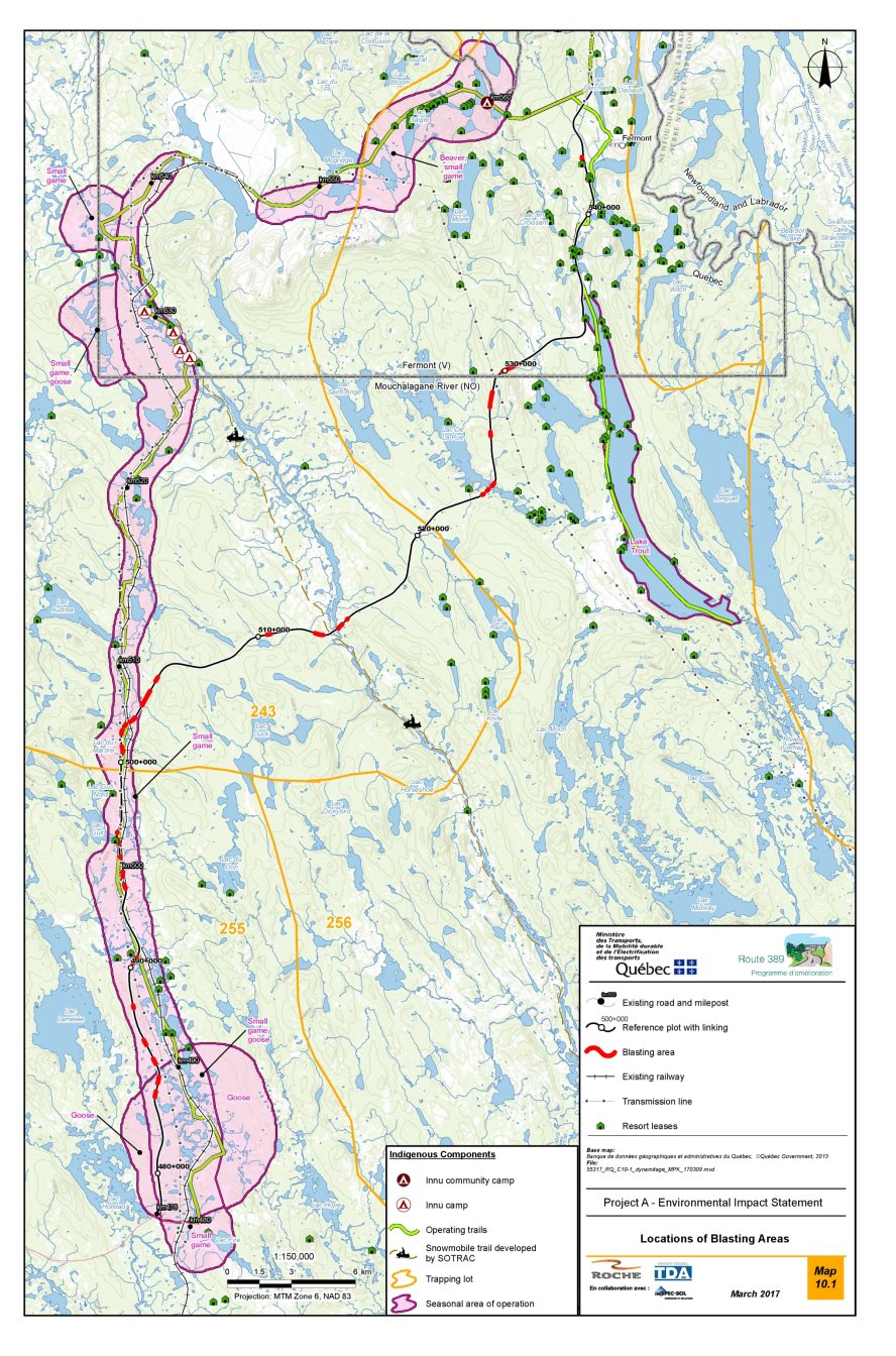
Source: MTMDET, 2017, page 41
The proponent has determined that, during the operational phase, the area of land that would no longer be available for traditional activities such as hunting and trapping would correspond to the right-of-way of the new highway and a buffer zone on either side of it. In calculating this buffer zone, the proponent has considered the worst-case scenario, i.e. functional loss of the boreal caribou habitat, which means 500 metres on either side of the new highway. Accordingly, the territory that would no longer be available amounts to 1.1% of lot 243, 0.6% of lot 255 and 1.2% of lot 256. The intensity of the impact related to loss of availability of the territory for the Innu would be below the criterion of < 5% established by the proponent to determine moderate intensity. The intensity of this impact would thus be low.
Finally, the proponent claims that the impacts on current use of the land and resources resulting from the presence and maintenance of the unpaved road would not be significant. It states that the frequency of occurrence of adverse effects would be low, since there will be only occasional traffic on the road (373 vehicles per day on average in 2022) and it would be used by road maintenance vehicles only when required. Also, according to the land use information available, most of the activities representing current use of the land and resources in the study area would take place on sites close to the present Route 389 but not to the alignment of the future route. Finally, the impacts on resources potentially associated with the presence and maintenance of an unpaved road are not likely to lead to adverse impacts on the various traditional activities of the First Nations that use the territory, with the exception of:
- Fishing around the site of the planned bridge crossing over the Pékans River on the new alignment (kilometres 513), which remains unlikely according to the proponent, since the approach and bridge are to be paved on 155 metres on both sides.
- Harvesting of berries, and only if this is done within 250 metres on either side of the future highway.
It considers, however, that these impacts could be reduced by the mitigation measures that are to be implemented to control erosion and limit sediment transport to watercourses, and by the use of a dust suppressant, when required.
Effects on archeological sites
The proponent says that project-related activities might have impacts on certain archeological sites that may exist in areas of archeological potential located within the limits of the right-of-way and the borrow pits. However, an archeological inventory done by the proponent in summer 2015 on the eight sites that may be affected by the work and by borrow pit operations did not find any new archeological sites.
The proponent points out, however, that although the archeological inventory confirmed the absence of archeological remains in the areas surveyed, it is still possible that such remains will be unearthed during the work. Therefore, to reduce the project's impacts on such remains, the proponent has committed to treat any incidental discovery of archaeological sites in accordance with the Cultural Heritage Act, by temporary protective measures, the evaluation of the discovery and an archaeological dig, if required. The proponent has also committed to inform First Nations of incidental discoveries. A revision of the route of the road could be considered necessary following discussions between the proponent, the First Nations and the Quebec Ministère de la Culture et des Communications in the event of significant discovery.
The Innu of Matimekush-Lac John have identified a cemetery along the Petite Rivière Manicouagan but it is located outside the project study area and the project will have no impact on the project.
6.6.3 Mitigation, monitoring and follow-up measures
Communication plan
To reduce the impacts of the construction period on the Innu's current use of the land and resources, the proponent undertakes to set up a communication plan in collaboration with the Innu First Nations of Uashat mak Mani-Utenam and Matimekush-Lac John. The object of this plan would be to inform the Innu of the work schedule, the nature of the work (e.g. forest clearing and blasting), temporary access restrictions (on land and navigable waterways) and the potential effects of the activities (noise, dust etc.). Users of the territory could thus plan or adapt their traditional and contemporary activities based on the disruption associated with the work. Notices would be issued at least 30 days before the commencement of each operation. To ensure the plan is implemented as effectively as possible, the proponent would hold preliminary discussions with the band councils to determine the communication procedures.
The proponent would also like to hold regular discussions with the band councils of the Innu nations of Matimekush-Lac John and Uashat mak Mani-Utenam to identify their concerns and proposals concerning the work and associated impacts on use of the land. To the extent possible, it will take account of the concerns and suggestions provided by the Innu First Nations in the design and planning steps related to mitigation measures, the work, the opening up of Nitassinan and effects on their traditional and contemporary activities.
The proponent undertakes to include a clause in its contracts requiring a minimum of 20% Indigenous labour. This minimum would be subject to availability of a workforce with the requisite mandatory qualifications. All trades present and required on the job site would be included in calculating this percentage. The proponent will inform the community of the jobs available and upcoming contracts through its communication plan.
General measures
- In collaboration with the Ministère des Forêts, de la Faune et des Parcs, inform the workers about the hunting and fishing rules that apply within the territory, as well as the regulations pertaining to the planned aquatic reserve on the Moisie River, as applicable.
- Before the completion of the work, restore access to the portions of territory where Innu camps are located within the right-of-way that is to be abandoned (between kilometres 490 and 507).
During the construction phase
- Install appropriate road signage in areas where the road alignment crosses snowmobile trails used for access to or travel within traplines.
- If necessary, after consultation with the concerned Innu, temporarily relocate snowmobile trails used for access to or travel within traplines.
- Relocate traplines affected by the work, or restore them after the work is completed.
- Minimize encroachments on parking areas, traplines and other facilities along the route, and make alternative parking areas available as required. Maintain access to this infrastructure.
- For crossings of waterways used by the Innu for navigation, guarantee that the structure has a vertical clearance of at least 1.5 metres from the upper limit of the bank.
- Treat any incidental discovery of archaeological sites in accordance with the Cultural Heritage Act, by temporary protective measures, the evaluation of the discovery and an archaeological dig, if required. A revision of the route of the road could be considered necessary following discussions between the proponent, the First Nations and the Quebec Ministère de la Culture et des Communications in the event of significant discovery.
Monitoring and follow-up
The proponent plans to follow up on use of the territory by members of the First Nations. This follow-up will entail various meetings with the tallymen of the three lots affected by the project, and other users, as necessary, in order to determine the impacts on use of the land during construction and operation of the road.
This follow-up would include the following stages:
The proponent has planned to conduct follow-up on the use of the territory by the members of the First Nations, which would include meetings with the tallymen as follows:
- Meeting with the tallymen of the three lots affected by the project, and other users, as necessary, in order to specifically identify the traditional activities that take place in the area of influence of the project before the start of construction, the period(s) when these activities take place, the quantities of wildlife resources trapped, hunted or fished at these locations, etc.;
- Meeting with the tallymen of the three lots affected by the project, and other users, as necessary, every year during the construction (four years) in order to inform them, for a given year, of the areas where work will be carried out and the nature and duration of the work; discussions with the tallymen about how they plan to change their normal habits concerning use of the territory in response to the project-related work and a description of the areas that will continue to be used despite the work; and
- Meeting with the tallymen of the three lots affected by the project, and other users, as necessary, two years after the end of road construction in order to determine how the presence of the road is impacting their activities and comparison with the data collected before the start of the project.
6.6.4 Comments received
Federal authorities
Health Canada indicated that it may be possible to adapt and/or add mitigation measures, if necessary, based on feedback from the proponent's communication program with the users concerned during the work (MTQ, 2015, p. 381), along with its complaints management system (MTMDET website), more specifically concerning the potential effects related to noise, dust and/or access to the territory.
Health Canada also recommended to the Agency to ask the proponent develop and implement a follow-up mechanism related to the use of lands and resources for traditional purposes during the construction and operation phases in collaboration with the users of the territory.
First Nations
The Innu First Nations of Uashat Mak Mani Utenam and Matimekush-Lac John have expressed concerns regarding the project's effects on flora and fauna, water quality, fish and fish habitat, air quality and ambient noise, which have been described in the preceding sections. The present section outlines the concerns expressed by members of these two First Nations regarding their use of the land and resources.
For example, the First Nations are concerned about the project's effects on cottages and camps and their use; the sustainability and use of hunting, fishing and gathering sites; the effects of the opening up and fragmentation of the territory and its accessibility to non-Indigenous resort activities; obstructions to navigation; and the project's effects on heritage, archeological sites and sites of cultural significance.
The Innu Nation of Matimekush-Lac John stated its view that the acceleration and intensification of development on the territory in an undisturbed natural environment are harmful. The Nation took this opportunity to express its disagreement with the proponent's claim that this is the best option from an environmental perspective, while the options of the status quo and of upgrading of the existing road would naturally have less impact on the environment and on their traditional activities. The First Nation added that the Innu advocate the conservation of virgin territories and environmental protection over economic benefits. They therefore disagree with the proponent who considers opening to the territory as beneficial to the Innu.
One of the most important concerns of the First Nations is the effect of a new road in terms of opening up the territory. This road may well facilitate access to and increase use of the territory by non-Indigenous people (building of cottages, hunting and fishing). They have indicated that there are already disputes between certain non-Indigenous users and the Innu over occupation of the territory, which will only be exacerbated (with the opening up of the territory) by this new road. They disagree with and are unhappy about the proponent's decision to leave it to the land use managers to minimize the effects of this opening up of the territory by informing them in writing of the First Nations' concerns.
The Grégoire family, which is the holder of trapline 255, observed that the proponent prefers the non-Indigenous experience and perspective over the Indigenous experience and perspective concerning the historical and contemporary use of the territory, which constitutes a serious lack of neutrality and objectivity. The family reports the presence of several camps or cottages on the territory of trapline 255. These are loaned within the family, thereby allowing the children and grandchildren to benefit from the territory and spend time there. Handing down customs to the younger generations of the family is an integral part of the traditional practices of Innu families on their hunting grounds.
The Innu Nation of Matimekush-Lac John has concerns about the project's effects on Innu archeological and cultural heritage. It wants to preserve its history and its cultural and spiritual heritage, and considers that not all measures have been taken to ensure the preservation of an important part of the Innu archeological and cultural heritage for the benefit of future generations. Considering that the region drained by the Mishta Shipu (Moisie River) is archeologically rich and that rivers are generally sites of great archeological potential, they feel it is important to undertake advanced archeological research in the places surrounding and within the road right-of-way, in close collaboration with the community. For example, the elders of Matimekush-Lac John have said that the project's study area encroaches directly upon a prime traditional Innu travel corridor linking the Pékans River to Wabush Lake. This corridor was not used only by the Innu families closest to the site: it also allowed traditional bands from Kaniapiskau and Ste-Marguerite to meet up with the Petiskapau and Moisie bands via Ashuanipi Lake and vice-versa.
The opportunities for restoration of the territory and the potential economic benefits for the Innu First Nations are among the aspects of interest identified during the consultations. The First Nations wish to be kept informed in a timely manner about business and job opportunities related to the preparatory work and the repair and construction of the road.
All the concerns of the First Nations have been compiled in the table in Appendix G, together with the proponent's and Agency's responses.
General public
No comments were received from the general public concerning the current use of lands and resources for traditional purposes by Indigenous peoples.
6.6.5 Agency's analysis and conclusions
Taking into account the implementation of the proposed mitigation measures and follow-up program, the Agency is of the opinion that the project is not likely to cause significant adverse environmental effects on the current use of lands and resources for traditional purposes or on structures, sites or things of historical, archeological, paleontological or architectural significance in the study area.
Some temporary constraints could hinder access to the territory during the construction phase. However, these effects will be reduced by the measures to be implemented to permit users of the territory to continue accessing it, such as relocation of snowmobile trails.
The Agency considers that the communication plan that the proponent wants to put in place inform the Innu communities about the upcoming work and associated impacts is an important element for reducing the effects on current use of the land and resources for traditional purposes. The Agency also points out that the proponent has indicated that it intends to remain attentive to the concerns of the Innu and hold discussions with them to find ways to reduce project impacts. Among other things, the proponent agrees to have regular meetings with First Nations to inform them of the progress of the project and discuss their concerns about the work.
According to the analysis of archeological potential and the surveys that have been done, no adverse impacts on archeological sites are anticipated. In the event of a fortuitous discovery during the work, the Agency notes that measures will be taken in accordance with the Cultural Heritage Act. If a major discovery is made, consideration may be given to modifying the alignment. The Agency also considers that the proponent has demonstrated that there will be little or no disturbance of or effects on places and sites that are culturally and archeologically significant to the Innu from the work and the presence of the road.
The proponent has determined that in the operational phase the area of territory that will no longer be available for the practice of traditional activities, which corresponds to the new road's right-of-way and a buffer zone of 500 metres on either side of it, corresponds to 1.1% of lot 243, 0.6% of lot 255 and 1.2% of lot 256.
In addition, according to the information available to the Agency, provided by the proponent and the First Nations, the territory located near the new road right-of-way would be little frequented by the Innu and they would not have any permanent facility.
With regard to access to the territory, a portion of the old Route 389 will continue to be maintained to allow camp/cottage owners to continue to have access. For the waterways used by the Innu as travel corridors, the Agency considers that the proponent's undertaking to guarantee that structures have a vertical clearance of at least 1.5 metres from the upper limit of the bank is adequate. Consequently, no obstruction to navigation is expected.
The Agency considers that all the measures planned by the proponent to mitigate the project's effects on the other valued components will help reduce the effects on the current use of lands and resources for traditional purposes. These measures concern fish and fish habitat, migratory birds, vegetation, terrestrial wildlife, air quality and noise.
The Agency is of the opinion that the proponent's commitment to conduct follow-up on the use of lands and resources for traditional purposes in collaboration with the First Nations will make it possible to adapt the work to address their concerns. The proponent's proposal to have regular meetings with the First Nations will allow the follow up on their concerns, regarding the opening of the territory, the jobs and the contracts.
7 Other Effects Considered
7.1 Effects of Accidents and Malfunctions
The environmental effects of accidents or malfunctions are among the elements to be examined under the former Act. In the context of the environmental assessment, an "accident" is defined as an unexpected and sudden event involving project components or activities. A "malfunction" denotes the failure of equipment or a system to function properly, leading to damage to valued components. This section provides an analysis of the environmental effects of project accidents or malfunctions.
As part of this project, the Agency examined the main accident and malfunction risks which include spills or leaks of oil or chemicals on the work site and on the road, fires and explosions and the associated effects on the environment. All valued components could be affected by accidents or malfunctions.
Based on its analysis, the Agency concludes that the project is not likely to cause significant adverse residual environmental effects in the context of accidents or malfunctions, giving the mitigation measures proposed by the proponent.
- The proponent has clearly identified the risks inherent in its project and plans to implement preventive measures, including adequate design, inspection and maintenance of equipment;
- The proponent plans to develop an emergency response plan providing for rapid and effective response in case of accident or malfunction.
The following subsections describe the potential major accidents and malfunctions as well as the essential elements of the proponent's analysis, and present the opinions of departmental experts, First Nations and the general public on which the Agency based its conclusions regarding the significance of the effects of accidents and malfunctions.
7.1.1 Identification of potential accidents and malfunctions
The proponent analyzed two types of accidents and malfunctions: accidental spills of hazardous materials and fire and explosion hazards.
Accidental spills of hazardous materials
The proponent indicated that accidental spills of hazardous materials can result from leaks from machinery, containers or tanks, during refuelling of machinery, and from leak-proof receptacles intended for equipment containment. These leaks could be related to equipment failure, human error, material failure, corrosion, seals, overload and overpressure.
The proponent indicated that a major spill could occur where equipment used to store large quantities of hazardous materials are present, such as tank trucks and fuel storage tanks, and that this equipment can be affected by major ruptures or failures. Nonetheless, it pointed out that the volumes of fuel associated with the construction work would generally be small.
According to the proponent, the likelihood of spills during the construction phase would be more important, given the intensity of construction site activities and the frequent handling of hazardous materials.
In the operation phase, accidents or malfunctions would be related to collisions between vehicles (cars, trucks, trains, machinery, etc.), leaks from vehicle tanks, or run-off-road accidents.
Based on the environmental emergency response registry for the 2012–2017 period, the proponent indicated that spills along Route 389 involved the following products: magnesium chloride (dust suppressant), motor oil, turbine oil, thermal oil, diesel, bitumen, and ammonium nitrate. The proponent states that the number of accidents should decrease, due to the project design and better road safety conditions (reduction of the number of level crossings, plan and profile geometry, reduction of the length of the course, etc.).
Fire or explosion
Fires are often related to the use or improper handling of petroleum and chemical products during hot work.
Explosions could occur when using explosives during the construction phase. On the work site, explosives would be mostly associated with rock cutting requiring blasting and with quarrying. Inert explosives would be stored and delivered separately from the detonators, making a spontaneous explosion impossible. The factors contributing to an accident involving an explosion would therefore be mainly related to error or negligence in the use or handling of explosives.
7.1.2 Proponent's assessment of potential environmental effects
According to the proponent, there is a real likelihood of an accidental spill during the construction phase, but the likelihood of it being handled efficiently and quickly, with the hazardous material removed completely from the natural environment, would also be high, so the residual effect should be low.
According to the proponent, because of the environmental measures but especially occupational health and safety measures implemented on the work sites, the likelihood of a fire or explosion occurring is low.
Effects of spills
The potential effects of a spill would involve direct contamination of soil, ground water, surface water and adjacent environments, whether terrestrial, aquatic or wetland. This contamination could have an indirect effect on wildlife using these aquatic or terrestrial habitats as well as on human activities dependent on wildlife (hunting, fishing and trapping).
The areas most vulnerable to spills are watercourses and bodies of water crossed by the road or located near it, as potential spills could spread rapidly. Spills on land or in wetlands, while also potentially causing adverse effects, would spread less rapidly than those in water, and would therefore allow for faster recovery, absorption or containment measures.
If an accident or malfunction causes a hazardous material spill near Perchard Lake, the town of Fermont's water intake could become contaminated. The proponent indicated that the risk of an accident near the shores of Perchard Lake would be very low since no work site facilities would be built there.
Effects of fires and explosion
As for the risk of explosion or fire, the fire or heat from the impact site following blasting could reach the surrounding forest, potentially triggering a forest fire that could result in the loss of plant communities and associated wildlife habitat.
7.1.3 Mitigation measures
Spill
The proponent intends to identify intervention mechanisms in an emergency response plan that would be developed in accordance with the terms of MTMDET's departmental emergency and security measures plan (Plan ministériel de mesures d'urgence et de sécurité civile) and regional emergency and security measures plan (Plan régional de mesures d'urgence et de sécurité civile). This emergency response plan, which would be developed for both the construction phase and the operation phase, would detail the main preventive measures, but also the actions to be implemented in case of emergency, the communication mechanisms and the links with the different levels of authorities.
In operation phase, the proponent indicated that the project would be a mitigation measure in itself since it would make the road safer by significantly improving its geometry. The Transportation of Dangerous Substances Regulation Footnote 28 sets out the rules to be followed to minimize spills through safe transportation based on high standards for different types of products.
Fire and explosion
In order to reduce the risk of fire, the proponent will implement various general measures, in particular:
- Comply with the MTMDET's Cahier des charges et devis généraux (general specifications), in particular article 11.2.2 "Forest fire prevention";
- train personnel and ensure they have the skills to perform the work involving the use of heat and flame;
- make employees aware of the importance of the precautions to reduce the risk of forest fire.
In the event of a major fire, explosion or spill, the Plan régional des mesures d'urgence et de sécurité civile for the Direction de la Cote-Nord would be implemented. This plan includes the participation of local stakeholders, including the Town of Fermont.
The Town of Fermont would be called on to participate in the response actions, depending on the gravity of the situation. For example, these measures could include all actions necessary to contain the spill, temporarily shut off the water supply, carry out water quality monitoring measures, implement an information system for citizens or take any other required actions. The Quebec Ministère de la Sécurité publique et Urgence Environnement would also be contacted.
During the operation phase, if an accident or major failure causes an uncontrolled spill, the water supply from Perchard Lake could be cut off temporarily. This situation would likely trigger the proponent's local events - emergency measures plan or, if required, the regional alert and mobilization process.
7.1.4 Views expressed
Federal authorities
Environment and Climate Change Canada recommends that the proponent identify and specify the appropriate standards and measures in the site contractor's service contract and ensure that these commitments are respected in the field, particularly with regard to preventive measures. It also recommends that the emergency response plan, which would be developed for the project, include maps identifying spill-sensitive environments. This mapping could be used as a reference tool that can guide response actions in the event of an accident, malfunction or spill of deleterious substances.
Given that the municipality of Fermont draws its water from Perchard Lake, which is partially located in the project study area, Health Canada recommends, as normally specified in the environmental protection specifications, to include, in its emergency response plan, a measure to inform without delay the municipality of Fermont in the event of a spill of petroleum products or other liquid hazardous materials.
First Nations
First Nations have expressed concerns about the effects of accidents or spills that could affect the aquatic environment. The proponent has committed, through regular meetings between the proponent and the First Nations, to discuss a communication process, and its terms, in the event of an accident or spill.
Public
There were no comments from the public regarding the effects of accidents and malfunctions.
7.1.5 Agency's analysis and conclusions
The Agency is satisfied with the characterization and assessment of potential project-related accidents and malfunctions presented by the proponent. It also took into account the opinions of the governmental authorities. It notes that the proponent has taken into account the risks of accidents or failures in the design of the project to prevent risks. The proponent has also taken into account the concerns of the Agency and the public and is committed to implementing emergency and response plans in the event of an accident.
Given the mitigation measures, response measures and emergency response plan that the proponent has committed to put into practice, the Agency believes that the project is not likely to cause adverse residual environmental effects in the context of accidents or malfunctions, giving the mitigation measures proposed by the proponent.
7.2 Effects of the Environment on the Project
According to the former Act, any changes to the project that may be caused by the environment must be taken into account in the determination of the environmental effects. The proponent has examined the effects of the environment on the project and has proposed measures aimed at reducing them.
7.2.1 Potential effects on the project
The effects of the environment on the project are mainly associated with extreme natural events, the presence of contaminated soils or failure of infrastructure located near the road.
According to the proponent, extreme precipitation events could cause heavy flooding and have a negative impact on the road, both in terms of engineering structures and road infrastructure. The road could even be weakened in the case of protracted flooding. These extreme precipitations could result in increased runoff amount and velocity, thus increasing the risk of mobilization and transport of sediments to watercourses at road crossing sites and downstream of them.
According to the proponent, however, the risk of flooding due to heavy precipitation is unlikely given not only the design of the road, but also the abundance of wetlands within the study area. Indeed, these natural environments have the capacity to retain rainwater, thus preventing sudden flooding downstream.
Increased precipitation in the form of rain or snow associated with current and projected climate change could result in environmental changes that could affect the new road infrastructure. The effects of climate change on pavements vary according to several factors, including road and soil type and geographic location. To address the potential effects of climate change, the proponent increased bridge and culvert design flows by 18%.
Forest fires could also have effects on the project. The proponent noted that major forest fires are relatively rare in the region. In the event of a forest fire, the proponent would initiate the deployment of specific and concerted response plans involving various stakeholders, including the Société de protection des forêts contre le feu.
The proponent considers that the risk of alteration of the road or its structures in the event of an earthquake would be practically nil. It pointed out that the road will be located in an area that, based on the available data, has had no major earthquakes and is one of the most stable regions in Quebec and even Canada. The probability of occurrence of a major earthquake is almost nil.
According to the proponent, certain sectors located in the project's zone of influence could present a risk of contamination. The sites would consist mainly of railway embankments, borrow pits and a snow dump. The potential effects of in situ contamination would be inadvertent soil reworking or exposure of contaminated water which could then potentially migrate to uncontaminated environments (soil, surface water, biological component, ground water).
The proponent also noted that risks associated with infrastructure or equipment failure that could affect the project would be very low, as there is little human-made infrastructure along the road. Also, in the event of a failure at the Fire Lake and Fire Lake North mine sites which are located near the project, emergency response plans and measures would be implemented by the mining companies to safely manage such a situation.
7.2.2 Mitigation measures
The proponent has proposed design elements and mitigation measures making it possible to avoid or reduce the environmental effects of environment-induced changes to the project:
- upgrading the road by improving drainage conditions would mitigate the effects of extreme precipitation events;
- culvert and bridge design should ensure free flow corresponding to the 25-year flood levels, which would be sufficient to accommodate the majority of extreme floods. This design would mitigate the restrictive effect on watercourses which could cause upstream overbank flows and increased downstream flow velocities;
- culvert design will take into account a potential increase of 18% in flows to address the effect of climatic variations or other extreme events;
- for landscaping, road embankments in areas at greater risk of erosion and along watercourses would be targeted for topsoil addition because of the scarcity of organic soil. This would help to filter some of the runoff before it reaches watercourses. Revegetation along watercourses would also help to reduce the risk of erosion;
- in the event of large flash floods, the proponent would perform follow-up to verify the integrity of the structures, thereby helping to ensure rapid detection of potential for failure;
- when required, repairs would be made (as applicable, fill and riprap, pavement structure repair, repaving, etc.), helping to ensure that the road and structures are maintained in good condition.
7.2.3 Views expressed
Federal authorities
Environment and Climate Change Canada notes that the proponent has considered climate change and the potential effects of climate change on its project, including in the design of the project and its components.
First Nations
No comments were received from First Nations regarding the effects of the environment on the project.
Public
The general public did not provide comments regarding the effects of the environment on the project.
7.2.4 Agency's analysis and conclusion
The Agency believes that the proponent has considered elements of the environment that could have effects on the project in the design of its project, that it has documented the potential accidents and malfunctions associated with these effects and that it has provided an adequate emergency response plan. The Agency concludes that the environmental conditions are not likely to have significant adverse effects on the project.
7.3 Cumulative Environmental Effects
Cumulative environmental effects are defined as effects that are likely to result when a residual effect of a project combines with the effects of other projects, works or human activities that have been or will be carried out. The purpose of the cumulative effects assessment is to determine the extent to which the residual environmental effects of the project on a valued component may combine with the effects of other physical activities that have been or may be carried out.
In the project, the Agency specifically selected the following two valued components for its analysis of cumulative environmental effects: boreal caribou and current use of lands and resources for traditional purposes by Aboriginal peoples.
According to the Agency, a significant cumulative adverse effect on boreal caribou would occur if the combined effects of past, current and future projects and activities would result in alterations to its critical habitat such that the disturbed habitat percentage within the QC-6 range exceeds 35%, as defined in the species recovery strategy.
According to the Agency, a significant cumulative adverse effect on Aboriginal peoples' current use of lands and resources for traditional purposes would occur if the combined effects of past, present, and future projects and activities would significantly disrupt traditional practices or activities by modifying access to traditional territory, quantity and quality of available resources.
Based on its analysis, the Agency concludes that this project is not likely to have significant cumulative effects on woodland caribou or the current use of lands and resources for traditional purposes.
The following subsections describe the approach and scope as well as the essential elements of the proponent's analysis and present the opinions of departmental experts, First Nations and the general public on which the Agency based its conclusions regarding the significance of the Project's cumulative effects in relation to the components selected.
7.3.1 Approach and scope
As part of the project, the Agency excluded the following valued components from its cumulative effects analysis: the atmospheric environment, wetlands and plant species at risk, avian wildlife, terrestrial mammals (other than boreal caribou), fish and fish habitat. The Agency supports its decision on the absence or low intensity of the anticipated residual effects of the project on these components and the fact that these effects are unlikely to be cumulative with the effects of other present, past or future projects in the environment where the project would be done.
The methodological approach used by the proponent for the cumulative effects assessment includes the following steps:
- identification of the valued components, determination of the spatial and temporal boundaries considered for each component and description of the indicators used;
- identification of projects, actions and events that may have affected the valued components, that are currently affecting them or that will affect them;
- description of the baseline conditions for each valued component and the associated historical trends;
- identification of the cumulative effects for each valued component selected;
- identification of the mitigation and environmental monitoring and follow-up measures;
- determination of the significance of cumulative effects.
The temporal boundaries selected are from 1974 to 2042, that is, the years corresponding to the beginning of the operation of the Mont-Wright mine and the founding of the town of Fermont, and extending to 20 years after the commissioning of the new road alignment, because of known concrete projects in the area and their approximate lifespan. Table 13 summarizes the valued environmental components selected, the spatial boundaries considered and the indicators selected.
Past, current and future projects, works and development activities considered within the spatial and temporal boundaries include mining projects, hydroelectric complexes and power lines, road transportation infrastructure, protected areas and wildlife reserves, and activities of Aboriginal and non-Indigenous communities in the vicinity of the site. A detailed list of these projects and activities is provided in Appendix K.
|
Valued component |
Spatial boundary |
Indicators |
|---|---|---|
|
Boreal caribou |
40 km around the center of the projected alignment. |
Maximum disturbance level so as not to interfere with the recovery of local populations (a maximum of 35% disturbance of the study area). |
|
Current use of lands and resources for traditional purposes by Innu First Nations |
3 traplines affected by the project (243, 255, 256). |
History of use, testimonies, area of the territory affected. |
7.3.2 Potential cumulative effects on boreal caribou
The proponent has determined that the project is not likely to cause significant cumulative environmental effects on boreal caribou, particularly because the rate of habitat disturbance induced by historic, existing and projected projects would be 23.3% in the study area determined by the proponent, i.e. 40 km around Route 389 which is the subject of this comprehensive study. This rate is below the maximum disturbance threshold recommended by the boreal caribou recovery strategy of 35%. Other cumulative effects on caribou such as fragmentation and disturbance would not have significant cumulative effects given the similar quality habitats that would be abundant in the vicinity.
The proponent has assessed the cumulative effects of the project, including historical, current, and projected disturbances to boreal caribou populations in the study area, because based on the Recovery Strategy for the Boreal Caribou (Environment Canada 2012), the rate of disturbance is the ultimate factor that most influences the growth, maintenance or decline of local boreal caribou populations. The management threshold is set at 35% disturbance for the area used by a local population, which would be a disturbance level that provides a probability of self-sustainment of 60% of boreal caribou populations (Environment Canada, 2012; Équipe de rétablissement du caribou forestier du Québec, 2013a).
Thus, in order to calculate the cumulative disturbance level of the study area, the proponent has taken into account past, existing and planned projects, actions and events within a radius of 40 km around the center line that are likely to have an effect on disturbance of boreal caribou habitat. A 500 m buffer zone has been added around these disturbances to account for caribou avoidance behavior (functional habitat loss) (Environment Canada, 2012).
According to the proponent, the anthropogenic and natural disturbances that are likely to have an effect on the populations would be: the development of the road network, railways and power lines, mining, agglomerations, recreational lease-holders, and forest fires under 40 years old. Figure 20 illustrates the impacted areas that were considered in the calculation of the natural and anthropogenic disturbance level (including a 500 m buffer zone) of boreal caribou habitat.
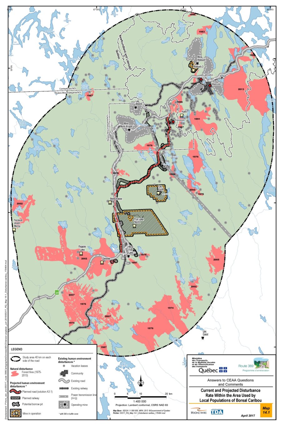
Source: MTMDET, 2017, page 79
|
Periods |
Elements |
Area affected in km2 (including a 500-m buffer zone around anthropogenic disturbances) |
Disturbance level (%) |
|---|---|---|---|
|
Source: MTMDET, 2017, page 81 |
|||
|
Natural disturbances |
|||
|
Existing |
Forest fires |
1,284.0 |
12.8 |
|
Anthropogenic disturbances |
|||
|
Existing |
Existing roads |
97.0 |
1.0 |
|
Rail line |
136.9 |
1.4 |
|
|
Power transmission line |
75.5 |
0.8 |
|
|
Mines |
228.3 |
2.3 |
|
|
Recreational lease-holders |
217.1 |
2.2 |
|
|
Fermont, Wabush and Labrador City metropolitan area |
25.5 |
0.3 |
|
|
Sub-total existing |
2064.2 |
20.6 |
|
|
Projected |
Proposed railway (Fire Lake North) |
10.2 |
0.4 |
|
Mining projects |
200.9 |
2.0 |
|
|
Route 389 improvement program |
52.9 |
0.5 |
|
|
Sub-total projected |
273.0 |
2.7 |
|
|
Total existing and projected |
2337.3 |
23.3 |
|
The proponent indicates that wildfires are the primary natural source of habitat alteration for woodland caribou in the region. According to the Canadian National Fire Database (2015), fires under 40 years old occupy a total of 1,284 km² of the study area, or 13% (Table 14).). According to the proponent, these fires may have forced the boreal caribou to temporarily abandon favorable habitats until they were favorable again. These natural disturbances have always reigned in this ecosystem and the caribou has adapted to them.
The proponent emphasizes that mining is the main anthropogenic activity that has influenced the development of most of the region's infrastructures, including the establishment of the municipality of Fermont. This mining development could have disrupted boreal caribou herds and affected their movements. The opening of the territory created by the exploration or exploitation activities also favors a greater human presence, which would increase disturbance, risks of collisions and poaching.
The proponent in the calculation of the disturbance level (including the 500 m buffer zone) also considered encroachment caused by agglomerations and cottage presence. No logging would be practiced on the portion of the study area that is located north of the northern limit of the forests attributable to Quebec.
Finally, according to the proponent, the improvement program for Route 389 would result in an additional disturbance of approximately 52.9 km² of boreal caribou habitat (including the right-of-way, borrow pits and the 500 m buffer zone covering the functional losses of habitat). The proponent stresses that, despite considering this area as good quality habitat, it represents only 0.5% of the area used by local populations of boreal caribou (10 040 km²). It assumes that individuals currently using these habitats will be able to move to similar habitats in the periphery.
The disturbance analysis of the area used by the local boreal caribou populations conducted by the proponent determined that the historical and existing disturbance level would be 20.6% and that the cumulative level (existing and projected) would be 23.3%. These levels are below the maximum disturbance threshold recommended by the boreal caribou recovery strategy of 35% (Table 14).
Disturbance levels for each habitat type required by the boreal caribou to complete its life processes were also calculated by the proponent and all rates are below the 35% threshold of disturbed habitats recommended by Environment Canada in the Woodland Caribou Recovery Strategy.
In addition to habitat loss and disturbance, the project would contribute to increased habitat fragmentation by creating a semi-permeable barrier for boreal caribou populations (Dyer et al. 2002). The proponent also points out that the project would promote an increase in caribou disturbance on a proportion of the territory. However, this effect would only be felt on a small area.
Finally, the proponent considers that the amount of undisturbed habitat within the study area would not jeopardize boreal caribou recovery in the area despite existing and future projects. It considers it important to add that, since the impact study was carried out, the creation of the "Caribous-Forestiers-de-Manouane-Manicouagan " biodiversity reserve would protect more than 10,200 km2 of targeted territory with suitable habitats for caribou needs, in a high density area approximately 80 km southwest of the project study area. This measure, which will limit anthropogenic disturbances in this sector, represents a positive impact, according to the proponent, for the East Manicouagan population who frequent the study area of the project.
7.3.3 Potential cumulative effects on current use of lands and resources by Innu First Nations
The proponent has determined that the project is not likely to cause significant cumulative effects on the current use of lands and resources for traditional purposes by Innu First Nations.
The spatial boundary for the assessment of cumulative effects of the project on current use of land and resources by the Innu is all three traplines lots (255, 256 and 243) that are likely to be affected by the project. According to the proponent, this area encompasses all the projects and concrete activities that were considered for the purposes of the analysis.
The proponent reports that, in general, iron ore mining ore in the Labrador Trough influenced the development of the majority of the region's infrastructure, including the establishment of the municipality of Fermont, the establishment of a road network and the establishment of lines and substations to supply the sector with electricity. Thereby, the main projects that have had a major impact on the use of the three traplines in the study area are the mines and the railway line linking the Mont-Wright mine to the Port-Cartier port facilities and the creation of the town of Fermont.
The Mount Wright, Fire Lake and Bloom Lake mines are currently operating within the three traplines (study area). The study area is also crossed by several power lines serving the city of Fermont and mining companies in the area.
In the coming years, the Fire Lake North and Knife Lake projects could increase the area devoted to mining activities. The proponent states that the Fermont (Mount Merry), Peppler Lake and Lake Lamêlée South iron mine projects, all within the confines of Trapline Lot 255, are at a stage of development that would not permit to establish the areas potentially exploited. According to the proponent, the current mining situation does not allow us to conclude that one of these projects could be realized.
Table 15 shows the current and future affected areas in the study area including the project under study as well as the trapline lots they would affect.
|
Period |
Activities |
Total Project Area (ha) |
Trapline lots |
||
|---|---|---|---|---|---|
|
243 |
255 |
256 |
|||
|
Source: MTMDET, 2017, page 76. |
|||||
|
Existing |
Roads |
464.2 |
X |
X |
X |
|
Railway |
386.6 |
X |
X |
- | |
|
Mining |
6,620.0 |
X |
X |
X |
|
|
Power lines |
743.8 |
X |
X |
X |
|
|
Town of Fermont |
821.0 |
- | - |
X |
|
|
Total existing |
9,035.6 |
That is 1.03% of the total lot area. |
|||
|
Projected |
Mining projects |
17,200.0 |
X |
X |
- |
|
Proposed railway line (Fire Lake North) |
213.6 |
- |
X |
X |
|
|
Route 389 Improvement Program |
487.1 |
X |
X |
X |
|
|
Total projected |
17,900.7 |
That is 2.04% of the total lot area. |
|||
|
Total (existing and projected) |
26,936.3 |
That is 3.07% of the total lot area. |
|||
The proponent believes that all existing projects have had varying degrees of impact on Innu land use, such as the opening of the territory, the fragmentation of the territory, the loss of areas used by the Innu, the loss of habitat for wildlife and plant resources harvested by the Innu.
Mining projects, which are the most important sources of impact on the study area, have also contributed to the transformation of air quality and the sound environment. The proponent stresses that these repercussions would have been strongly felt by the members of the Innu families concerned. According to the proponent, these families would consider that these projects resulted in significant changes and would have caused harm to the traditional Innu activities on the affected trapline lots.
The effects of the future Route 389 would therefore be cumulative with those of past and future projects and thus accentuate the already existing effects on the Innu. These effects would have repercussions on the accessibility of the territory, the size of the territories available for the practice of traditional activities as well as on the availability of resources (wildlife, plants). The cumulative total area that would be available for current use of lands and resources represents three percent of the available land on the three lots. In addition, several leases for recreational activities or temporary shelters were granted in the sector to non-natives. These leases would be concentrated near Fermont and therefore mainly in the northern part of trap lot 256. The effects of each of these leases are limited, but the potential addition of new leases in this area could alter the use of the land by Innus in this area.
The proponent considers that the creation of jobs within the Innu community of Uashat Mak Mani-Utenam to meet the needs of this road project and other projects in the area could have short-term effects on the use of the territory and the Innu traditional way of life. For example, instead of spending long periods of time in the forest in order to meet their families' food needs or for enjoyment, some Innu carry out these activities only on weekends or only for recreational purposes. In addition, thanks to the higher salaries paid in remote areas, community members will have more money to buy equipment and vehicles required for hunting, fishing and trapping activities, but much less time to carry out these activities.
Lastly, conservation projects such as planned aquatic reserves or biodiversity reserves (Gensart Lake and Moisie River) also affect these traplines. The overall effects are positive, however, as long as traditional activities can be maintained in the areas concerned.
Finally, the proposed Moisie River aquatic reserve and Gensart Lake biodiversity reserve projects are located in part on these same trapline lots. However, these territories would be exempt from all forms of logging, exploration and mining and energy production. Current uses and rights (fishing, hunting, recreation, aboriginal activities, outfitters, etc.) would nevertheless be maintained. These projected reserves will therefore have overall positive effects since traditional activities would be preserved and maintained in these areas.
7.3.4 Views expressed
Federal authorities
Environment and Climate Change Canada is satisfied with the proponent's analysis of cumulative effects on the woodland caribou and recognizes that forest fires are a major factor contributing to the cumulative effects within this caribou range. Based on information provided by the proponent, and the Report on the Progress of Recovery Strategy Implementation for the Woodland Caribou, Boreal population (ECCC 2017), it appears that the population and distribution objectives identified in the woodland caribou recovery strategy would not be compromised in the short to medium term.
First Nations
The Innu First Nations have expressed concern about the cumulative effects on Innu rights and activities. They are particularly concerned about the cumulative effects of linear projects (highways, roads, railways and transmission lines) on Innu rights and activities in connection with the opening up and fragmentation of the territory and wildlife habitats. They also expressed concern about the increasing presence of non-Indigenous people within the territory.
The Innu First Nation of Uashat mak Mani-Utenam notes that industrial, mining and energy development projects, forestry, the construction of towns, highways and roads, as well as the establishment of outfitter operations and cottage/resort sites, among others in the Nitassinan have had and have devastating effects for the Innu, including preventing them from frequenting and occupying large portions of their traditional lands and destroying the flora and fauna necessary to continue their traditional activities and maintain their Innu way of life. This First Nation adds that the Innu have, to this day, continued their traditional practices, customs and traditions and activities, including in the project area.
Innu First Nations describe the Moisie River system as a major transportation route historically used by the Innu to access their hunting grounds. It is a territory of interest for the transmission of knowledge to new generations. Users and Elders have expressed the importance of this territory in terms of history (old portage and salmon fishing) and ecological importance. Due to its recognized importance and potential pressures that may be exerted on its boundaries, special consideration should be given to the area covered by Moisie's proposed reserve in the cumulative effects analysis of the project. The Agency notes that the proponent has worked closely with the Quebec Ministère des Forêts, de la Faune et des Parcs to reduce the effects of Route 389 on the proposed Moisie aquatic reserve.
Public
The Agency did not receive any comments from the public about cumulative effects.
7.3.5 Agency's analysis and conclusion
The Agency is of the view that the cumulative effects of the project would not be incompatible with the recovery objectives for the boreal caribou. Indeed, the analysis conducted by the proponent demonstrates that the disturbances generated by the project, combined with past, present and future projects, would not contribute to exceeding the maximum disturbance threshold of 35% established in the boreal caribou recovery strategy. The set of mitigation measures planned and to be put in place by the proponent would limit habitat loss and disturbance, disturbance and mortality of individuals. The monitoring and follow-up programs proposed by the proponent would also ensure that these mitigation measures are put in place adequately and efficiently. The proponent is also committed to raising the awareness of its workers and contractors as well as the public and Aboriginal peoples about the potential consequences of disturbance and mortality of individuals on the recovery of the caribou population. It also wishes, taking into account the results of its monitoring and follow-up programs, to put in place adaptive management measures if issues arise during the construction and operation of the road.
According to the Agency, the cumulative effects on the current use of land and resources by Aboriginal people would be limited. The proportion of encroachments on trapline lots by past, current and future projects would be less than five percent (total 3.07%). These effects should not significantly modify access to the territory for First Nations since the proponent will put in place measures that would reduce barriers to traffic on waterways, snowmobile and quad trails. Several mitigation measures. Many mitigation measures are planned by the proponent to mitigate the project's effects on other valued components, including fish and fish habitat, migratory birds, terrestrial wildlife and flora, which should help to preserve the quantity and quality of resources for First Nations.
7.4 Effects on the Capacity of Renewable Resources
In accordance with the requirements of subsection 16(2) of the former Act, the Agency must consider the capacity of renewable resources likely to be significantly affected by the Project in order to meet present needs without compromising the ability of future generations to meet their needs.
The potential effects of the Project on renewable resources, water, terrestrial wildlife, birds and fish were assessed in detail in the environmental impact statement. Special attention was paid to water resources, fish and fish habitat, birds and other wildlife species.
The effects of the Project on some of these resources were assessed in accordance with the scope of the Project assessment (see Sections 6.2 to 6.5). The significance of the residual effects was also assessed. This assessment shows that the Project's effects will not compromise the environmental integrity of these valued components and will not significantly or irreversibly alter their use. Consequently, the Project will not significantly reduce the ability of current or future generations to obtain drinking water supplies or harvest wildlife, and will not compromise the viability of fisheries and the sustainability of ecosystems.
Considering the implementation of the mitigation and compensation measures proposed by the proponent, the Agency concludes that no renewable resources will be significantly impacted by the Project and, therefore, the Project is not likely to cause significant adverse environmental effects on renewable resource capacity.
8 Potential Impacts on Potential or Established Aboriginal or Treaty rights
In this chapter, the Agency addresses the potential or established Aboriginal or Treaty rights of the Innu First Nations that may be affected by the project, namely the Innu First Nations of Uashat mak Mani-Utenam and Matimekush-Lac John. The Agency's analysis and conclusions on the potential adverse effects of the project on these rights is also presented. Appendix G provides a summary of the concerns and issues raised by the First Nations as part of the environmental assessment as well as the responses provided by the proponent and Agency.
8.1 Potential or Established Aboriginal or Treaty Rights in the Project Area
In 1979, the Innu First Nations of Quebec and the Atikamekw First Nations jointly submitted a comprehensive land claim to the federal and provincial governments with the objective of concluding a modern treaty.
The Innu First Nations of Quebec have since formed separate negotiating groups to represent them. In 2005, given their close family connections and the shared use of their traditional territory, the Innu First Nations of Uashat mak Mani-Utenam and Matimekush-Lac John designated the Ashuanipi Corporation to negotiate their comprehensive land claim with the two governments on their behalf. To date, no treaty has been signed with the Innu First Nations of Quebec.
The comprehensive land claim of the Innu First Nations of Quebec, including the First Nations of Uashat mak Mani-Utenam and Matimekush-Lac John, corresponds to the traditional territory of the Innu people, or Nitassinan, which means "our land" in Innu-aimun. Located in Quebec and Labrador in eastern Canada, this vast ancestral land covers the eastern part of the Labrador Peninsula in Quebec, and corresponds to Saguenay—Lac-Saint-Jean, the regional county municipalities of Haute-Côte-Nord and Manicouagan, the southern part of the Caniapiscau Regional County Municipality and the eastern part of the Regional County Municipality of Minganie.
In the 1950s, the Innu First Nations of Uashat mak Mani-Utenam and Matimekush-Lac John were granted traplines by the Quebec government. The First Nations view these traplines as family lands occupied and used by Uashaunnuat families who, in accordance with Innu traditions, customs and practices, are responsible for preserving the natural resources found on the lands. The traplines are located in the Saguenay Beaver Reserve (Sept-Îles division), which is part of the Nitassinan. The Saguenay Beaver Reserve is an area of 134,541 km² (21 652 301 hectares) created by the Quebec government in 1954 and subject to the Regulation Respecting Beaver Reserves of the Quebec Act Respecting the Conservation and Development of Wildlife.
The project is located entirely on the Nitassinan, more specifically on traplines 243, 255 and 256 (Figure 18) on which the Jourdain and Grégoire families continue to engage in traditional activities. It is located roughly 280 kilometres south of the two communities of the Innu First Nation of Matimekush-Lac John (Matimekush and Lac John) and roughly 700 kilometres north of the two communities of the Innu First Nation of Uashat mak Mani-Utenam (Uashat and Mani-Utenam).
The Innu First Nations of Uashat mak Mani-Utenam and Matimekush-Lac John have asserted Aboriginal rights, including Aboriginal title, and Treaty rights over all of the Nitassinan, including the natural resources found there. They are opposed to the implementation of any development project in their traditional territory without their consent. Moreover, they assert that they have the autonomy to make decisions affecting the Nitassinan.
They present their asserted Aboriginal rights over the Nitassinan as a collection of rights, including but not limited to hunting, fishing, gathering and trapping rights as well as the right to engage in Aboriginal customs and Innu cultural, spiritual and traditional activities.
8.2 Assessment of the Potential Impacts on Aboriginal Rights
During the course of the environmental assessment, the Innu First Nations of Uashat mak Mani-Utenam and Matimekush-Lac John expressed concerns about the possible impacts of the project on the exercise of their potential Aboriginal rights, on the practice of their traditional activities, specifically hunting, trapping, fishing, and gathering, and on their historical and cultural heritage.
More specifically, they believe that the possible impacts of the project on their potential Aboriginal rights would concern primarily:
- the occupancy and use of the lands, the use of waterways and waterbodies, and the development of the natural resources of the Innu First Nations;
- the way of life, culture, and activities, practices, customs and traditions of the Innu First Nations;
- the spiritual and other connections of the Innu First Nations with the part of their Nitassinan that is potentially affected by the project, thus restricting the exercise of their spiritual and cultural practices;
- the cultural and historical heritage of the Innu First Nations, such as cultural and burial sites;
- areas used as sites for the transmission of traditional knowledge;
- the capacity of the Innu First Nations to meet their natural obligations to protect and manage the Earth and the environment;
- the jurisdiction and authority of the Innu First Nations over their lands;
- the relationships between Aboriginal and non-Indigenous communities, related primarily to access to and development of natural resources.
8.2.1 Proponent's assessment
In its environmental impact statement, the proponent provided information on the land claims in the region and on the current use of the asserted areas and the exercise of traditional activities on those areas by the Innu First Nations of Uashat mak Mani-Utenam and Matimekush-Lac John. The proponent examined the biophysical effects of the project, including alternatives to and alternative means of carrying out the project, as well as the cumulative effects on the current use of lands and resources for traditional purposes.
Land use and historical and cultural heritage
According to the proponent, the land use patterns of the traditional Uashaunnuat families that engage in traditional activities on the traplines affected by the project have changed significantly in recent years. Whereas the grandparents used to travel to the lands for long periods of time (sometimes up to nine months), the current Uashaunnuat users prefer to travel to the lands four or five times a year for short periods of time (namely in the fall, during the holiday period and in the spring, but seldom in summer). Among the many factors behind these changes is the ageing of the main users, the changing attitude of young people vis-à-vis activities in the forest, and the relative distance of the sector from the communities of Uashat and Mani-Utenam, even though access to the sector has actually improved.
The proponent indicates that the Uashaunnuat users generally have only one main camp per trapline and that they use prospector tents or lean-tos for shelter when moving around on their lands.
Although the proponent recognizes that information on the contemporary use of the area, particularly traplines 255, 256 and 243, by Innu First Nations is limited, it has indicated that the seasonal use of the area by Uashaunnuat users is concentrated on traplines 255 and 243, along Route 389, from the vicinity of Fire Lake mine to the Quebec–Newfoundland and Labrador border.
The proponent mentions that the interviews with the main users of traplines 243, 255 and 256 added no new information to what was already known. It noted, however, that those interviewed made a point of indicating that, regardless of the seasonal harvesting areas identified or mapped in other studies, the Uashaunnuat use the entire area of their respective traplines, moving to wherever the resources are found.
According to the proponent, the Innu First Nations holders of traplines 243, 255 and 256 fish for lake trout, lake whitefish and northern pike, hunt ducks, geese, hares, caribou and moose, depending on the season, gather berries (blueberries, partridgeberries and cloudberries) and trap small game (hares, partridges, porcupines, beavers).
Opening up of the area
According to the proponent, the new access roads (Route 389, roads to the mines or vacation areas and energy corridors) should facilitate the use of the area by the Innu First Nations as well as their ability to travel to new sectors where they will be able to carry out traditional activities. The proponent is also of the view that, with the exception of some land use conflicts associated with the opening up of the area, these roads will facilitate travel between Innu communities and traplines where hunting, fishing and trapping activities are carried out.
A number of cottage/rough shelter leases have been issued to non-Indigenous individuals in the territory asserted by the Innu First Nations. These leases are concentrated near Fermont, i.e., in the northern part of trapline 256. The proponent is of the view that the impact of each of these leases is limited, but recognizes that the addition of new leases in this part of the territory could alter the use of the area by the Innu First Nations.
Lastly, the proponent notes that the Quebec government's planned conservation projects, such as aquatic or biodiversity reserves (Lake Gensart and Moisie River), will also have impacts on the three traplines (243, 255 and 256). The anticipated effects would be generally positive, to the extent that they would safeguard the practice of traditional First Nations activities in these areas, while increasing recreational and tourism services.
Proponent's conclusions
The proponent concludes that the Route 389 improvement project will not restrict the use of the area by the Innu First Nations, but rather will alter their use of the area in both positive and negative ways. Taking into account the implementation of all the mitigation measures (see Appendix B), the proponent has determined that the project is not likely to cause significant adverse effects on the current use of lands and resources for traditional purposes or on archaeological sites that may be discovered and therefore that the project would not have significant effects on the asserted Aboriginal rights of the Innu First Nations of Uashat mak Mani-Utenam and Matimekush-Lac John.
Nonetheless, the proponent undertakes to meet with the Innu First Nations of Uashat mak Mani-Utenam and Matimekush-Lac John on a regular basis to provide information and discuss their concerns and proposals regarding the work, the opening up of the area and the impact of the work on the practice of their traditional activities.
8.2.2 Agency's analysis
To assess the potential impacts of the project on Aboriginal rights, the Agency examined the following categories of rights and interests:
- Availability of resources for traditional purposes. Is the availability of resources and traditional activities likely to be impacted by the project?
- Access to the area. Is access to the area for the purpose of using traditional resources or to sites having cultural value likely to be impacted by the project?
- Cumulative effects related to the opening up of the area. Could the opening up of the area to non-Inigenous have long-term effects on the availability of resources for traditional purposes and on access to and use of the area?
The Agency took into account the conclusions of the environmental assessment on the current use of lands and resources for traditional purposes and the mitigation measures (see Appendix B) proposed by the proponent. The main mitigation measures, which are also potential accommodation measures, would mitigate the effects of the project on the current use of lands and resources for traditional purposes. They are described in the sections that deal with the atmospheric environment, wetlands and vegetation, including special status species, fish and fish habitat, birds and bird habitat, and terrestrial mammals and associated habitat.
Availability of resources for traditional purposes
The availability of resources for traditional purposes is closely tied to the right of Innu First Nations to engage in their practices, traditions and customs, particularly hunting, fishing, trapping and gathering.
According to the Uashat mak Mani-Utenam Innu First Nation, the project will transform the natural environment of their traditional territory in an irreparable and irreversible manner, particularly traplines 243, 255 and 256, where the Grégoire and Jourdain families exercise their traditional activities. In the case of trapline 255, one of the members of the Grégoire family, Raymond Grégoire, mentioned that although his family has always been open to possible development on that trapline, he hopes that the development of the region will not further compromise his ability to live off the resources of his land and to engage in his traditional activities.Footnote 29
The Uashat mak Mani-Utenam Innu First Nation mentions that the many mining, forestry and other developments projects, including the construction of towns, cottages and vacation facilities, have had devastating effects on the Innu, including the destruction of the plant and wildlife species they need to exercise their traditional activities and maintain their Innu way of life.
Agency's conclusion on the availability of resources for traditional purposes
In chapter 6.6, the Agency concludes that the residual effects of the project on the availability of traditional resources would not be significant.
According to the information available to the Agency, the new road would not pass near valued sites for traditional activities, including fishing, hunting, trapping and gathering (see figure 18). Moreover, the Agency is of the view that availability of resources outside the immediate project area will remain sufficient for the exercise of the potential or established Aboriginal or Treaty rights of the Innu First Nations.
This conclusion is based on information provided by the Innu First Nations to the effect that the sectors used by traditional families change depending on the abundance of wildlife resources. Although the Uashaunnuat users say that they use the entire area of their respective traplines, a given sector can be left unused for four to six years in order to ensure that sufficient resources are available for harvesting. It is also important to bear in mind that the size of the area that would no longer be available for the practice of traditional activities would be relatively small, namely 1.1% of trapline 243, 0.6% of trapline 255, and 1.2% of trapline 256.
The Agency is of the view that the measures put forward by the proponent to mitigate the effects of the project on other valued components will contribute to reducing the impacts on the availability of resources for traditional purposes. These measures concern fish and fish habitat, migratory birds, wetlands, vegetation, terrestrial mammals, air quality, and noise.
Access to the land
Access to the land is a key aspect of the right of the Innu First Nations to engage in their practices, traditions and customs, specifically hunting, fishing, trapping and gathering, and also to preserve their natural and cultural heritage.
The Uashat mak Mani-Utenam Innu First Nation claims that it has had a relationship with the Nitassinan, including Mishta-Shipu (Moisie River) for thousands of years. It notes that the road will cross Rivière aux Pékans, which is one of the two largest tributaries of the majestic Mishta-Shipu, which has historically been the main means of accessing their traditional territory and which is of cultural and spiritual significance.
The Uashat mak Mani-Utenam Innu First Nation mentions that the project, which is located entirely on their traditional territory, the Nitassinan, will have significant cultural, spiritual, social, community and economic impacts on their way of life, including that of the traditional families.
The Innu of Uashat mak Mani-Utenam that use the existing Route 389 to access some of their camps, including road segments that could be abandoned or that will no longer be maintained by the proponent but rather by another entity, are concerned about the impacts associated with access to the territory and their rights to engage in their traditional and contemporary activities in their territory.
Agency's conclusion on access to the territory
To assess the possible effects of the project on potential Aboriginal rights of these First Nations, the Agency took into account the conclusions of the environmental assessment on the current use of lands and resources for traditional purposes, including such factors as historical and cultural heritage. In chapter 6.6, the Agency concludes that the residual effects of the project on access to the territory would not be significant. This conclusion is based on the fact that exclusion from land or loss of access to resources would generally be limited to the immediate project area and restricted to the construction phase.
Cumulative effects related to the opening up of the territory
The Uashat mak Mani-Utenam Innu First Nation mentions that the many past mining, forestry and other development projects, including the construction of towns, cottages and vacation facilities, have had devastating effects on the Innu, specifically by preventing them from using and occupying large areas of their traditional lands, which are essential to their ability to exercise their traditional activities and maintain their way of life. The two Innu First Nations expressed concerns about the cumulative effects of opening up the territory that could occur following the construction of the new road.
The Agency believes that, in the long term, the new road would give non-Indigenous individuals access to the asserted territory for vacation and fishing activities, among other things. These activities and the presence of non-Indigenous users could have long-term effects on the potential or established Aboriginal or Treaty rights in respect of hunting, fishing, and trapping, specifically on traplines 243, 255 and 256. The opening up of the territory could have impacts on both the availability of traditional resources, such as brook trout and moose, and on access to the territory associated with the potential issuance of new cottage leases on the territory and the potential increase in land use conflicts between Aboriginal and non-Indigenous users.
The two First Nations have proposed measures that would serve as accommodation for the impacts related to the opening up of the territory:
- Impose a moratorium on the issuance of cottage leases in the project area, particularly near the new road segments;
- Prohibit non-Innu from engaging in recreation or tourism activities in the project area, particularly at or near the new road segments, including fishing in the area of the bridge over Rivière aux Pékans;
- Ensure Innu participation in the planning and implementation of road maintenance work;
- Ensure a minimum Aboriginal employment requirement of at least 20% or contracts by mutual agreement with the two First Nations.
The Agency and the proponent undertake to forward these proposed accommodation measures to the appropriate authorities, namely the Quebec Department of Energy and Natural Resources and the Caniapiscau Regional County Municipality.
8.3 Issues to be Addressed During the Regulatory Approval Phase
Following the Minister's decision on the environmental assessment, Fisheries and Oceans Canada, as the responsible authority for the project, may consult the affected First Nations regarding authorizations to be issued under the Fisheries Act for the implementation of the project, including fish habitat compensation projects.
8.4 Agency's Conclusions Regarding Adverse Impacts on Potential or Established Aboriginal or Treaty Rights
The Agency believes that the mitigation measures proposed by the proponent are critical to minimizing the possible effects of the project on the potential or established Aboriginal or Treaty rights of the Innu First Nations of Uashat mak Mani-Utenam and Matimekush-Lac John. Moreover, the mitigation measures serve as accommodation measures that should ensure that the Innu First Nations are able to continue to exercise these rights in the short and medium term.
The Agency is of the view that proponent's commitment to hold regular meetings with the Innu First Nations of Uashat mak Mani-Utenam and Matimekush-Lac John is key to ensuring follow-up of project-related issues and concerns and to developing solutions in collaboration with the First Nations.
However, the Agency is of the view that in the longer term, the opening up of the territory could have additional effects on potential or established Aboriginal or Treaty rights, and that the implementation of additional measures related to the management of lands and resources by the appropriate authorities could serve as accommodation for these effects.
The Agency notes that the proponent undertakes to inform the competent authority, the Caniapiscau Regional County Municipality, of this issue.
Once the Minister has issued her Environmental Assessment Decision Statement, the Agency will forward the information collected during the environmental assessment, related to the land-use issue, to Fisheries and Oceans Canada and Infrastructure Canada, the responsible authorities, which have project-related course of actions for authorizations and funding respectively.
9 Follow-up Program
Pursuant to the former Act, every comprehensive study must include a consideration of the need for, and the requirements of, a follow-up program, for verifying the accuracy of the conclusions of the environmental assessment and determining the effectiveness of the measures taken to mitigate the adverse environmental effects of a project. The results of a follow-up program can also support the implementation of adaptive management measures designed to mitigate unanticipated adverse environmental effects.
Fisheries and Oceans Canada and Infrastructure Canada, the responsible authorities, must ensure that a follow-up program is developed and implemented with the support of federal authorities.
To develop the directions of the federal follow-up program required as part of the environmental assessment, the federal authorities took into account the proponent's commitments and the provincial requirements, and identified follow-up requirements that fall within the federal government's areas of jurisdiction. These requirements were determined on the basis of the nature of the project's environmental effects, the uncertainties concerning the predictions or effectiveness of the mitigation measures, as well as the concerns raised by the public and First Nations.
As part of the federal follow-up program, the proponent has committed to monitoring air quality, fish and fish habitat, avian species at risk and their habitat, boreal caribou, bats and current use of lands and resources for traditional purposes, as shown in Table 16.
The proponent has also committed to monitor and follow-up on the renaturalization of abandoned portions of roads and areas disturbed by the work and the transplantation of brown-edged pussytoes.
|
Valued component |
Program elements |
Timetable and/or frequency |
Expert Department |
|---|---|---|---|
|
Air quality |
Construction phase:
Operation phase:
|
|
|
|
Fish and fish habitat |
|
|
Fisheries and Oceans Canada |
|
Birds and their habitat |
|
|
Environment and Climate Change Canada |
|
Boreal caribou |
|
|
Environment and Climate Change Canada |
|
|
Environment and Climate Change Canada |
|
|
Bats |
|
|
Environment and Climate Change Canada |
|
Current use of lands and resources for traditional purposes |
|
|
Responsible authorities |
The federal authorities will collaborate with the proponent on developing the details of the follow-up program in keeping with their respective mandates and expertise. The program will take into account the terms and conditions of the federal and provincial authorizations and approvals required to carry out the project, any changes in environmental conditions, and environmental effects that could occur during project implementation. The results of the follow-up program will be reported to the departments and agencies concerned. The results, or instructions on how to obtain the results, will be posted on the Canadian Environmental Assessment Registry (https://ceaa-acee.gc.ca/050/evaluations/proj/66250?&culture=en-CA).
10 Conclusions and Recommendations of the Agency
To reach a conclusion on the significance of the environmental effects of the project, the Agency considered the following elements:
- the documentation submitted by the proponent;
- the analyses and findings of the Federal Environmental Assessment Committee;
- comments received from the public, the Matimekush-Lac John Innu First Nation and the Uashat Mak Mani-Utenam Innu Nation;
- the obligation to apply for authorization under the Fisheries Act for work that would lead to serious harm to fish.
Taking into account the implementation of the proposed mitigation measures and the commitments made by the proponent, the Agency concludes that the project is not likely to cause significant adverse environmental effects.
Upon completion of a public consultation on this report, the Minister of Environment and Climate Change will consider the report and the observations which were presented on the latter in order to decide whether, given the implementation of the mitigation measures and monitoring program which are considered appropriate, the project is likely to result in significant adverse environmental effects. The project will then be referred back to the responsible authorities, Fisheries and Oceans Canada and Infrastructure Canada, to make their decision under section 37 of the former Act.
11 References
Atlas des oiseaux nicheurs du Québec (AONQ). 2011. Guide du participant (version 2). Regroupement Québec Oiseaux, Canadian Wildlife Service, (Environment Canada) and Bird Studies Canada, Quebec, 110 pp.
Bouchard, M.A. 1989. Subglacial landforms and deposits in Central and Northern Québec, Canada, with emphasis on Rogen moraines. Sedimentary Geology, vol. 62, p. 293-308.
Canadian Council of Ministers of the Environment (CCME). 1999. Canadian water quality guidelines for the protection of aquatic life: Dissolved oxygen (freshwater). In: Canadian environmental quality guidelines, 1999, Canadian Council of Ministers of the Environment, Winnipeg.
Canadian Council of Ministers of the Environment (CCME). 2007. Guidance Document on Continuous Improvement (CI) and Keeping-Clean-Areas-Clean (KCAC). Canada-wide Standards for Particulate Matter and Ozone.
Canadian Environnemental Assessment Agency. (CEAA). 2015. Technical Guidance for Assessing Physical and Cultural Heritage or any Structure, Site or Thing. https://www.canada.ca/en/environmental-assessment-agency/services/policy-guidance/technical-guidance-assessing-physical-cultural-heritage-or-structure-site-or-thing.html
Centre de donnés du Patrimoine naturel du Québec (CDPNQ). 2008. Factsheets on susceptibility of endangered or vulnerable vascular plants to forestry work. 774 pp.
CHIROPS. 2011. Espèces de chauve-souris du Québec. Réseau québécois d'inventaires acoustiques de chauves-souris. Joint project between Quebec Biodome, Ministère des Ressources naturelles and Envirotel 3000 inc.
CLD Caniapiscau. 2010. Profil socio-économique fermontois 2010. 39 p.
Committee on the Status of Endangered Wildlife in Canada (COSEWIC). 2013. COSEWIC assessment and status report on the Bank Swallow Riparia riparia in Canada. Committee on the Status of Endangered Wildlife in Canada. Ottawa. ix + 48 pp.
Committee on the Status of Endangered Wildlife in Canada (COSEWIC). 2015. Search for wildlife species: COSEWIC wildlife species assessments database.
Consortium Roche-Dessau. 1995. Aménagement hydroélectrique Sainte-Marguerite-3. Suivi environnemental 1994-1995. Inventaire de la grande faune et de la petite faune. Sainte-Foy, Québec: le Consortium, octobre 1995. 137 pp. + appendices.
Cornell Lab of Ornithology. 2016. eBird: Explore data. Cornell Lab of Ornithology and National Audubon Society. https://ebird.org/home
Courtois, R. and J.-P. Ouellet. 2002. Modélisation des interactions entre le caribou, l'orignal et le loup dans la forêt boréale, Québec, Canada. Société de la faune et des parcs du Québec, Université du Québec à Rimouski. 25 pp.
Couturier, S., J. Donald, R. Otto and S. Rivard. 2004. Démographie des troupeaux de Caribous migrateurs-toundriques (Rangifer tarandus) au Nord-du-Québec et au Labrador. Ressources naturelles, de la Faune et des Parcs, Direction de l'aménagement de la faune du Nord-du-Québec et Direction de la recherche sur la faune. 71 pp.
Couturier, S., R. Courtois, H. Crépeau, L.P. Rivest and S. Luttich. 1996. Calving photocensus of the rivière George caribou herd and comparison with an independent census. Rangifer, 9: 283–296.
Desrosiers, N., R. Morin and J. Jutras. 2002. Atlas des micromammifères du Québec. Société de la faune et des parcs du Québec, Direction du développement de la faune, Fondation de la faune du Québec, 91 pp.
Ducks Unlimited Canada (DUC). 2009. Plan de conservation des milieux humides et de leurs terres hautes adjacentes de la région administrative de la Côte-Nord. 89 pp. http://www.ducks.ca/
Dyer, S.J., J.P. O. Neill, S.M. Wasel and S. Boutin. 2002. Quantifying barrier effects of roads and seismic lines on movements of female woodland caribou in northeastern Alberta. Canadian Journal of Zoology, 80: 839–845.
Environment Canada. 1996. Federal policy on wetland conservation. Implementation guide for Federal Land Managers. 32 pp.
Environment Canada. 2012. Recovery Strategy for the Woodland Caribou, Boreal population (Rangifer tarandus caribou) in Canada. Species at Risk Act Recovery Series. Ottawa, Environment and Climate Change Canada, iv + 138 pp. http://www.registrelep-sararegistry.gc.ca/virtual_sara/files/plans/rs_caribou_boreal_caribou_0912_e1.pdf
Environment Canada. 2014a. Avoidance guidelines: General nesting periods of migratory birds in Canada. http://www.ec.gc.ca/paom-itmb/default.asp?lang=En&n=AB36A082-1&pedisable=true
Environment Canada. 2014b. North American Breeding Bird Survey web site: Population trends and annual indices for Canada, data-version 2012. Environment Canada. https://open.canada.ca/data/en/dataset/2cc215a2-f010-4083-bff2-ee9f028a6b69
Environment Canada. 2015a. Management Plan for the Rusty Blackbird (Euphagus carolinus) in Canada. Species at Risk Act Management Plan Series. Environment Canada, Ottawa. iv + 26 pp. https://www.canada.ca/en/environment-climate-change/services/species-risk-public-registry/management-plans/rusty-blackbird-2015.html
Environment Canada. 2015b. Recovery Strategy for Little Brown Myotis (Myotis lucifugus), Northern Myotis (Myotis septentrionalis), and Tri-colored Bat (Perimyotis subflavus) in Canada [Proposed]. Species at Risk Act Recovery Strategy Series. Environment Canada, Ottawa. ix + 110 pp. http://www.registrelep-sararegistry.gc.ca/virtual_sara/files/plans/rs_LittleBrownMyotisNorthernMyotisTricoloredBat_e_proposed.pdf
Environment Canada. 2016a. Recovery Strategy for the Common Nighthawk (Chordeiles minor) in Canada. Species at Risk Act Recovery Strategy Series. Environment Canada, Ottawa. vii + 49 pp. http://www.sararegistry.gc.ca/virtual_sara/files/plans/rs_common%20nighthawk_e_final.pdf
Environment Canada. 2016b. Recovery Strategy for the Olive-sided Flycatcher (Contopus cooperi) in Canada. Species at Risk Act Recovery Strategy Series. Environment Canada, Ottawa. vii + 52 pp. http://www.registrelep-sararegistry.gc.ca/virtual_sara/files/plans/rs_olive-sided%20flycatcher_e_final.pdf
Environment Canada. 2016c. Recovery Strategy for the Wolverine (Gulo gulo), Eastern population, in Canada. Species at Risk Act Recovery Strategy Series, Environment Canada, Ottawa, vii + 23 pp. http://www.registrelep-sararegistry.gc.ca/virtual_sara/files/plans/rs_wolverine_eastern_population_e_final.pdf
Environment and Climate Change Canada (ECCC). 2017. Report on the Progress of Recovery Strategy Implementation for the Woodland Caribou (Rangifer tarandus caribou), Boreal population in Canada for the Period 2012-2017. Species at Risk Act Recovery Strategy Series. Environment and Climate Change Canada, Ottawa. ix + 94 pp. https://registrelep-sararegistry.gc.ca/default.asp?lang=En&n=7037FCE4-1
Environment and Climate Change Canada (ECCC). 2018. National Inventory Report 1990-2016 - Greenhouse Gas Sources and Sinks in Canada: Executive Summary. 16 pp. https://www.canada.ca/en/environment-climate-change/services/climate-change/greenhouse-gas-emissions/sources-sinks-executive-summary-2018.html
Équipe de rétablissement du caribou forestier du Québec. 2013a. Plan de rétablissement du caribou forestier (Rangifer tarandus caribou) au Québec – 2013-2023 developed for the Ministère du Développement durable, de l'Environnement, de la Faune et des Parcs, Faune Québec. 110 pp. http://www3.mffp.gouv.qc.ca/faune/especes/menacees/fiche.asp?noEsp=53
Équipe de rétablissement du caribou forestier du Québec. 2013b. Lignes directrices pour l'aménagement de l'habitat du caribou forestier (Rangifer tarandus caribou) developed for the Ministère du Développement durable, de l'Environnement, de la Faune et des Parcs. 24 pp. + 1 appendix. http://www3.mffp.gouv.qc.ca/faune/especes/menacees/fiche.asp?noEsp=53
Feldhamer, G.A., B.C. Thompson and J.A. Chapman (eds). 2003. Wild Mammals of North America. Biology, Management, and Conservation. Second Edition. Baltimore, MD: The John Hopkins University Press.
Fisheries and Oceans Canada. 2013. Fisheries Protection Policy Statement. 22 pp.
Fisheries and Oceans Canada. 2016. Guidelines for Watercourse Crossings in Quebec. 73 pp. + appendices.
Frid, A., L.M., Dill. 2002. Human-caused disturbance stimuli as a form of predation risk. Conserv Ecol 6:11.
Fortin, C., V. Banci, J. Brazil, M. Crête, J. Huot, M. Huot, R. Lafond, P. Paré, J. Shaefer, and D. Vandal. 2005. National recovery plan for the wolverine (Gulo gulo) [Eastern Population]. National Recovery Plan No. 26. Recovery of Nationally Endangered Wildlife (RENEW). Ottawa, Ontario. 33 pp.
Gauthier, M., G. Daoust, and R. Brunet. 1995. Évaluation préliminaire du potentiel des mines désaffectées et des cavités naturelles comme habitat hivernal des chauves-souris cavernicoles au Québec. 104 pp.
Gingras, A. and B. Malouin. 1993. Inventaire aérien du caribou dans la zone de chasse 19 sud (partie ouest) en mars 1991. Ministère du Loisir, de la Chasse et de la Pêche Direction régionale de la Côte-Nord, Service de l'aménagement et de l'exploitation de la faune. 26 pp.
Gingras, A., R. Audy and R. Courtois. 1989. Inventaire aérien de l'orignal dans la zone de chasse 19 à l'hiver 1987-88. Direction régionale de la Côte-Nord, Service de l'aménagement et de l'exploitation de la faune. 58 pp.
Gouvernement du Québec (2008). Réserve aquatique projeté de la rivière Moisie: Plan de conservation. http://www.mddelcc.gouv.qc.ca/biodiversite/aquatique/moisie/PSC_Moisie.pdf
Grilo, C., J.A. Bissonette and M. Santos-Reis. 2009. «Spatial-temporal patterns in Mediterranean carnivore road casualties: consequences for mitigation». Biological Conservation, vol. 142. p. 301-313.
Heppell, S. 2015. Inventaire aérien du caribou forestier (Rangifer tarandus caribou) au nord du réservoir Manicouagan en mars 2014.Ministère des Forêts, de la Faune et des Parcs, Direction de la gestion de la faune Côte-Nord. 18 pp. + appendices.
Hogman, T.P., D.J. Harrison, D.D. Katnik and K.D. Elowe. 1994. Survival in an intensively trapped marten population in Maine. Journal of Widlife Management, 58:593-600.
Joly, M., S. Primeau, M. Sager and A. Bazoge. 2008. Guide d'élaboration d'un plan de conservation des milieux humides, Première édition, Québec, Ministère du Développement durable, de l'Environnement et des Parcs, Direction du patrimoine écologique et des parcs. 68 pp.
Lamontagne, G., H. Jolicoeur and S. Lefort. 2006. Plan de gestion de l'ours noir 2006-2013. Ministère des Ressources naturelles et de la Faune, Direction du développement de la faune, 487 pp.
Leblond, M., J. Frair, D. Fortin, C. Dussault, J.-P. Ouellet and R. Courtois. 2011. Assessing the influence of resource covariates at multiple spatial scales: an application to forest-dwelling caribou faced with intensive human activity. Landscape Ecology, 26: 1433–1446.
Lefort, S. and S. Massé. 2015. Plan de gestion de l'orignal au Québec 2012-2019, Ministère des Forêts, de la Faune et des Parcs – Secteur de la faune et des parcs, Direction de l'expertise sur la faune et ses habitats et Direction générale du développement de la faune. 443 pp.
Mazerolle, M. 2004. Amphibian road mortality in response to nightly variations in traffic intensity. Herpetologica, 60: 45-53.
Ministère du Développement durable, de l'Environnement, de la Faune et des Parcs (MDDEFP). 2013a. Statistiques de chasse et de piégeage pour la zone de chasse 19 sud (incluant les réserves) et l'UGAF 60. https://mffp.gouv.qc.ca/le-ministere/etudes-rapports-recherche-statistiques/statistiques-de-chasse-de-piegeage/
Ministère du Développement durable, de l'Environnement, de la Faune et des Parcs (MDDEFP). 2013b. Liste des espèces désignées menacées ou vulnérables au Québec. http://www3.mffp.gouv.qc.ca/faune/especes/menacees/liste.asp
Ministère du Développement durable, de l'Environnement, de la Faune et des Parcs (MDDEFP). 2013c. Critères de qualité de l'eau de surface. 3e édition. Québec. Direction de l'état de l'environnement. 510 pp + appendices. http://www.mddelcc.gouv.qc.ca/eau/criteres_eau/index.asp
Ministère du Développement durable, de l'Environnement et de la Lutte contre les changements climatiques (MDDELCC). 2015. Lignes directrices relativement aux niveaux sonores provenant d'un chantier de construction industriel, Québec. 1 p.
Ministère du Développement durable, de l'Environnement et de la Lutte contre les changements climatiques (MDDELCC). 2018. Inventaire québécois des émissions de gaz à effet de serre en 2015 et leur évolution depuis 1990, Québec, Direction générale de la réglementation carbone et des données d'émission. 33 pp.
Moisan, M. 1996. Rapport sur la situation du carcajou (Gulo gulo) au Québec. Ministère de l'Environnement et de la Faune, Direction de la faune et des habitats. 65 pp.
Mosnier, A., J.-P. Ouellet and R. Courtois. 2008. Black bear adaptation to low productivity in the boreal forest. Écoscience, 15: 485–497.
Ministère des transports. 1998. Politique sur le bruit routier. 13 pp.
https://www.transports.gouv.qc.ca/fr/ministere/role_ministere/Documents/politique_bruit.pdf
Ministère des Transports du Québec (MTQ). 2014. Cahier des charges et devis généraux – Infrastructures routières: Construction et réparation, édition 2015. Ministère des Transports du Québec, Direction du soutien aux opérations – Décembre 2014. 333 pp.
Ministère des Transports du Québec (MTQ). 2016. Mesures d'atténuation environnementales temporaires. (Available as an appendix of MTMDET, 2016)
Ministère des Transports, de la Mobilité durable et de l'Électrification des transports (MTMDET). 2015. Consortium Roche-TDA. Programme d'amélioration de la route 389 entre Fire Lake et Fermont (Kilomètres 478 à 564), Étude d'impact. 494 pp. and appendices.
Ministère des Transports, de la Mobilité durable et de l'Électrification des transports (MTMDET). 2016. Consortium Roche-TDA. Programme d'amélioration de la route 389 entre Fire Lake et Fermont (Kilomètres 478 à 564), Réponses aux questions et commentaires de l'ACÉE. 248 pp. and appendices.
Ministère des Transports, de la Mobilité durable et de l'Électrification des transports (MTMDET). 2017. Consortium Roche-TDA. Programme d'amélioration de la route 389 entre Fire Lake et Fermont (Kilomètres 478 à 564), Complément d'information à la deuxième demande d'information et modifications au projet. 92 pp. and appendices.
Ministère des Transports, de la Mobilité durable et de l'Électrification des transports (MTMDET). 2018a. Consortium Roche-TDA. Programme d'amélioration de la route 389 entre Fire Lake et Fermont (Kilomètres 478 à 564), Réponses aux questions et commentaires de l'ACÉE, 3e série. 72 pp. and appendices.
Ministère des Transports, de la Mobilité durable et de l'Électrification des transports (MTMDET). 2018b. Consortium Roche-TDA. Programme d'amélioration de la route 389 entre Fire Lake et Fermont, Programme de compensation de l'habitat du poisson (version finale). 15 pp. and appendices.
Payette, S. and L. Rochefort. 2001. Écologie des tourbières du Québec-Labrador. Les Presses de l'Université Laval, Québec. 621 pp.
Prescott, J. and P. Richard. 1996. Mammifères du Québec et de l'Est du Canada. Éditions Michel Quintin. Waterloo. 399 pp.
Prescott, J. and P. Richard. 2004. Mammifères du Québec et de l'est de l'Amérique du Nord. Quintin Michel. 304 p.
Santerre, E. 2012. Caribous du troupeau de la rivière George - Le MRNF fait connaître les résultats de l'inventaire. http://communiques.gouv.qc.ca/gouvqc/communiques/GPQF/Aout2012/16/c7587.html
Semlitsch, R.D. 2000. Principles for management of aquatic-breeding amphibians. Journal of Wildlife Management, 64: 615-631.
Société de la faune et des parcs. 2002a. Protection des espèces menacées ou vulnérables en forêt publique – L'aigle royal (Aquila chrysaetos). Société de la faune et des parcs du Québec, Ministère des Ressources naturelles du Québec, Direction de l'environnement forestier.
Société de la faune et des parcs. 2002b. Protection des espèces menacées ou vulnérables en forêt publique – le pygargue à tête blanche (Haliaeetus leucocephalus). Société de la faune et des parcs du Québec, Ministère des Ressources naturelles du Québec, Direction de l'environnement forestier.
Société de la faune et des parcs. 2002c. Protection des espèces menacées ou vulnérables en forêt publique – le faucon pèlerin (Falco peregrinus). Société de la faune et des parcs du Québec, Ministère des Ressources naturelles du Québec, Direction de l'environnement forestier.
Sun, J.W.C and P.M. Narris. 2005. Anthropogenic sounds differentially affect amphibian call rate. Biological conservation, 121: 419-427.
Taillon, J., M. Festa-Bianchet, and S.D. Côté. 2012. Shifting targets in the tundra: Protection of migratory caribou calving grounds must account for spatial changes over time. Biological Conservation. 147: 163-173.
World Bank. 2011. Greenhouse gas emissions mitigation in road construction and rehabilitation: A toolkit for developing countries. Washington, DC: World Bank. 65 pp. http://documents.worldbank.org/curated/en/660861468234281955/pdf/696590ESW0P1010UBLIC00GHG0Web0final.pdf
12 Appendices
Appendix A Spatial Boundaries and Rationale
|
Valued component |
Study area boundaries and rationale |
|---|---|
|
Atmospheric environment |
Air quality—general study area:Footnote 30 The proponent anticipates that emission sources will be confined to work areas, all located near the highway or borrow pits. It believes that air quality will be affected slightly in the immediate vicinity of the work site. Sound environment—general study area: The proponent considers the general study area to be sufficient to characterize the sound environment likely to be altered by the project during both the road construction and operation phases. The study area for the construction phase is larger because of the temporary work sites (for example borrow pits and disposal site, greenhouse gases, etc.). |
|
Vegetation |
Land vegetation: The proponent expanded the general study area to include the four alignment alternatives for the access road to Lac De La Rue (approximately 50 m on either side of the centre line) to assess losses resulting from construction work, including temporary roads outside the general study area. Wetlands: During the environmental assessment, the proponent modified the spatial boundaries to incorporate the total natural wetland area into the study area, even where the threshold of 300 m on either side of the route is exceeded. Special-status plant species—general study area: The proponent considers the general study area to be sufficient because the impact is primarily related to the direct presence of the highway or its deforestation right-of-way (including temporary roads during the construction phase). |
|
Birds and bird habitats |
Land birds and water birds—general study area: The proponent considers the general study area to be sufficient to identify the adverse effects of the project on this component (for example the loss or disturbance of habitats). For information, according to Environment and Climate Change Canada's avoidance guidelines, the buffer zone to be established around nests to protect species from disturbance caused by human activities ranges from 1 m to 50 m. It may be as large as 300 m, to protect the nests of certain species such as the olive-sided flycatcher and the rusty blackbird (Environment and Climate Change Canada, 2016). The width is sufficient to identify the species in all critical lands and areas that straddle the road alignment because they are seldom larger than 2 ha (Gauthier and Aubry, 1995). Birds of Prey—800 m on either side of the road alignment: A study area 1.6 km wide (800 m on either side of the road alignment) has been established to take into account recommended buffer zones (setbacks) around golden eagle, bald eagle and peregrine falcon nests to minimize the disturbance caused by human activities (Société de la Faune et des Parcs, 2002a, 2002b and 2002c). The radius of the buffer zone required during the nesting period ranges from 300 m to 700 m depending on the species in question. This width takes into account all other species of birds of prey because their ranges are smaller. |
|
Fish and fish habitats |
The study area for fish and fish habitat includes 300 m downstream and 200 m upstream of water crossing sites, the four alignment alternatives for the access road to Lac De La Rue, the watercourses within the boundaries of the borrow pits and those that will be crossed by temporary roads. The proponent states that the 200 m upstream are used to assess the quality of the habitats and determine whether it is necessary to ensure free passage to them. The 300 m downstream are used to assess direct and indirect impacts. Access roads are included to assess the impacts of this activity at potential crossing sites. |
|
Terrestrial mammals and their habitats |
Large wildlife—20 km on either side of the alignment: The proponent believes that this area reflects the significant movements of these species Boreal Caribou - 40 km radius around the route (total 1,004,000 ha): This study was established following recommendations from the Recovery Team of the Ministère des Forêts, de la Faune et des Parcs. This area corresponds to a portion of the landscape in which boreal caribou live. Bats and other terrestrial mammals—general study area: The size of the home range of small wildlife and bats in the region varies. Some species, such as the grey wolf, American marten, fisher and lynx, have very large home ranges, while others, such as red fox, ermine and weasel, have smaller movements. The proponent states that direct environmental effects (for example loss and disturbance of habitats) will occur on the right-of-way of the highway, in the immediate vicinity and at the borrow pits. The presence of the highway may indirectly modify their behaviour by creating an edge effect (habitat fragmentation). Nevertheless, given the low throughput expected on the proposed Route 389 (100 to 200 vehicles per day) and the width of the road (30 m to 35 m), the highway will not be a barrier to movement, and the general study area was considered sufficient to assess the direct and indirect effects of project components on these species. |
|
Current use of lands and resources for traditional purposes, and sites and items of archaeological, heritage or historical significance. |
The study area includes the trapping lots that the proposed highway will cross, namely lots 243, 255 and 256. The proponent believes that this area makes it possible to understand how trappers and their families use the land and how much of the lot is affected by the alignment, to determine the impact that the proposed highway will have on their access to and use of the land and on their traditional resources. Archaeology—general study area: The proponent considers the general study area to be sufficient since the goal is to determine whether prehistoric or historic Native American or Euro-Canadian archaeological sites are present or likely to be discovered during the construction work, within the right-of-way. |
Appendix B Mitigation Measures
This appendix presents, for each valued component, the mitigation measures that the Canadian Environmental Assessment Agency believes are necessary to mitigate the environmental effects of the North American Lithium Project. The proponent has committed to implementing all of these measures, in addition to those set out in its environmental impact assessment and supplementary documents.
To avoid repetition, some mitigation measures in a particular section may apply to more than one valued component.
Note that additional mitigation measures may be prescribed by the Minister as part of her decision-making process and issuance of a decision statement and in other authorizations that may be issued by the federal government.
|
Valued component |
Mitigation measures |
|---|---|
|
ATMOSPHERIC ENVIRONMENT Air quality, greenhouse gas, ambient noise |
Air quality:
Greenhouse gas
Ambient noise:
|
|
WETLANDS AND BROWN-EDGED PUSSYTOES (special-status plant species) |
General measures:
To reduce effects on wetlands:
To reduce effects on brown-edged pussytoes, a special-status species: For individuals located outside the highway right-of-way:
For individual plants located within the highway right-of-way:
|
|
FISH AND FISH HABITAT The water environment including the quality of surface water, aquatic and riparian vegetation and fish species. |
Schedule of work:
Design of the crossing structures:
Erosion and sediment transport control during the construction phase and operation of borrow pits
Mitigation measures when using temporary structures in fish habitat General measures
Temporary bypass of a watercourse
Containment and pumping of water from upstream to downstream of the watercourse
Temporary crossing of watercourses
Specific measures to be implemented during the redevelopment of sections of watercourse
Blasting
Temporary closure of construction site
Site rehabilitation
Specific measures to prevent water and aquatic environment contamination by petroleum hydrocarbons or other contaminants:
During the operation phase (road maintenance)
|
|
BIRDS AND BIRD HABITATS Water birds, land birds including species at risk, and critical habitat features including terrestrial vegetation, wetlands and waterbodies. |
General measures:
Measures to reduce habitat effects:
Mitigation measures when discovering any nest containing eggs or chicks. Note: For the bank swallow (a species at risk), nest protection begins at the conception of the nest Footnote 31. Thus, the application of mitigation measures for species at risk must begin as soon as the nest in conception is discovered.
Mitigation measures for bank swallow (specie at risk):
|
|
TERRESTRIAL MAMMALS AND THEIR HABITATS Micro-mammals with special status, small wildlife, large wildlife, boreal caribou and bats with special status. |
General mitigation measures:
Measures specific to Boreal Caribou (Threatened status under the Species at Risk Act):
Measures specific to Little Brown Bats and Northern Bats (Endangered status under the Species at Risk Act):
|
|
CURRENT USE OF LAND AND RESSOURCES BY INDIGENOUS PEOPLE Current use of lands and resources for traditional purposes and buildings, sites or things of historical, archaeological, paleontological or architectural significance. |
General measures:
During the construction phase
|
Appendix C Summary of the Federal and Provincial Regulatory Framework for Valued Components in the Environmental Assessment
The table below summarizes the provincial and federal regulatory framework for each valued component identified in the environmental assessment. To determine the significance of the residual environmental effects of the Route 389 Improvement between Fire Lake and Fermont Project, the Agency took into consideration, to the extent possible, all applicable federal and provincial acts and regulations as well as criteria and/or guidelines.
|
Valued Component |
Regulatory Framework |
|
|---|---|---|
|
Federal |
Provincial |
|
|
Atmospheric environment |
Air Quality Canadian Ambient Air Quality Standards http://www.ec.gc.ca/default.asp?lang=En&n=56D4043B-1&news=A4B2C28A-2DFB-4BF4-8777-ADF29B4360BD These standards are health-based air quality objectives for pollutant concentrations in outdoor air. They relate solely to fine particulate matter and ground-level ozone, two pollutants of concern to human health and the major components of smog. Greenhouse Gases (GHGs) Greenhouse Gas Reporting Program Any installation generating annual greenhouse gas emissions of 50,000 tonnes or more in equivalent units of carbon dioxide per year must declare these under this Environment and Climate Change Canada program (refer to section 46 of the Canadian Environmental Protection Act). |
Air Quality Clean Air Regulation and air quality criteria http://www.mddelcc.gouv.qc.ca/air/criteres/index.htm The province uses standards and criteria to assess air quality and to study projects generating air contaminant emissions that are submitted to it for authorization. The standards consist of maximum values and are set out in the Clean Air Regulation. The criteria are reference levels used to evaluate emissions of certain unregulated contaminants. Greenhouse Gases (GHGs) Regulation Respecting Mandatory Reporting of Certain Emissions of Contaminants into the Atmosphere http://legisquebec.gouv.qc.ca/en/ShowDoc/cr/Q-2,%20r Emitters are required to report their greenhouse gas emissions. The reporting threshold for greenhouse gas emissions is 10,000 tonnes of CO2 equivalent emissions. Ambient Noise Directive 019 on the mining industry http://www.mddelcc.gouv.qc.ca/milieu_ind/directive019/ This directive stipulates that the reference noise level for a stationary source associated with a mining activity must be assessed in accordance with the prescriptions of Instruction Note 98-01 (handling of noise-related complaints and requirements pertaining to companies causing the noise). The noise levels measured must meet the requirements established under this instruction note. The directive also includes requirements related to vibrations caused by blasting, including maximum vibration velocities as a function of ground vibration. Instruction Note 98-01http://www.mddelcc.gouv.qc.ca/publications/note-instructions/98-01.htm |
|
Water quality |
Canadian Water Quality Guidelines http://ceqg-rcqe.ccme.ca/download/en/201 These guidelines are intended to provide protection of freshwater and marine life from anthropogenic stressors such as chemical inputs or changes to physical components. Guidelines are numerical concentrations or narrative statements. Ambient water quality guidelines developed for the protection of aquatic life provide the science-based benchmarks for a nationally consistent level of protection for aquatic life in Canada. List of Toxic Substances Managed under theCanadian Environmental Protection Act(1999) The List of Toxic Substances in Schedule 1 of the Canadian Environmental Protection Act (CEPA) includes substances that are considered to be toxic as defined in Section 64 of the Act. The Government of Canada has the authority to regulate and authorize other instruments to prevent or control the use and/or discharge of these substances. The Government of Canada adds substances to Schedule 1 of CEPA based on the recommendation of the Minister of the Environment and the Minister of Health. |
Quality Criteria for Protection of Aquatic Life http://www.mddelcc.gouv.qc.ca/Eau/criteres_eau/fondements.htm#sante-humaine Quality criteria are established for each contaminant and each water use. The quality criteria for preventing the contamination of water and aquatic organisms are intended to protect water and aquatic organisms from contamination that may pose a threat to current and future human consumption. |
|
Fish and fish habitat |
Fisheries Act http://laws-lois.justice.gc.ca/eng/acts/f-14/ The Act is intended to protect the productivity of commercial, recreational and First Nations fisheries. Section 35 of the Act states that no work, undertaking or activity may be carried out that results in serious harm to fish that are part of a commercial, recreational or First Nations fishery, or to fish that support such a fishery, unless authorization for such purpose is obtained from the Minister of Fisheries and Oceans Canada. All serious harm to fish must be addressed through a fish habitat compensation plan to offset the loss of fish habitat. Furthermore, section 36 of the Act states that "no person shall deposit or permit the deposit of a deleterious substance of any type in water frequented by fish, or in any place under any conditions where the deleterious substance or any other deleterious substance that results from the deposit of the deleterious substance may enter any such water." The Governor in Council may, however, permit the use of a natural water body frequented by fish for the disposal of mine waste. This requires an amendment to the Metal Mining and Effluent Regulations so that the water body can be added to Schedule 2 thereof. In such a case, the project proponent must develop and implement a fish habitat compensation plan to offset the loss of fish habitat in accordance with section 27.1 of the Metal Mining and Effluent Regulations. Certain fish species are protected under the Species at Risk Act (see the birds component for more details on this legislation). |
Act Respecting the Conservation and Development of Wildlife http://legisquebec.gouv.qc.ca/en/ShowDoc/cs/C-61.1 Regulation Respecting Wildlife Habitats http://legisquebec.gouv.qc.ca/en/ShowDoc/cr/C-61.1,%20r.%2018/ The Act sets out various prohibitions related to the conservation of wildlife resources as well as various safety measures. It also specifies the rights and obligations of hunters, fishers and trappers. Under section 128.6, it is prohibited to carry out any activity that is likely to alter a biological, physical or chemical component peculiar to an animal or fish habitat. However, the Minister may authorize such an activity subject to certain conditions. Wildlife habitats include fish habitats and are defined in the Regulation Respecting Wildlife Habitats. In Quebec, eight fish species are designated as vulnerable or threatened within the meaning of the Act Respecting Threatened or Vulnerable Species. Twenty-five other species are identified as likely to be designated as threatened or vulnerable (refer to the birds component for more details concerning this Act). |
|
Birds and bird habitat |
Migratory Birds Convention Act, 1994 http://laws-lois.justice.gc.ca/eng/acts/M-7.01/index.html Migratory Birds Regulations http://laws-lois.justice.gc.ca/eng/regulations/C.R.C.%2C_c._1035/ Migratory Bird Sanctuary Regulations http://lois-laws.justice.gc.ca/eng/regulations/C.R.C.%2C_c._1036/ In Canada, as many as 658 different species of birds have been identified, including 555 migratory species covered by the Act. This Act and its regulations provide protection for migratory birds, including the prohibition against disturbing or destroying the nests and eggs of migratory birds. For example, under subsection 5.1 of the Act, it is prohibited to deposit a substance that is harmful to migratory birds in waters or an area frequented by migratory birds or in a place from which the substance may enter such waters or such an area. Species at Risk Act http://laws-lois.justice.gc.ca/eng/acts/S-15.3/ Some bird species are protected under this Act. The purposes of the Act are to prevent wildlife species from being extirpated or becoming extinct, to provide for the recovery of wildlife species that are extirpated, endangered or threatened as a result of human activity and to manage species of special concern to prevent them from becoming endangered or threatened. As part of an environmental assessment carried out under the Canadian Environmental Assessment Act, 2010 (the former Act), the Agency is legally bound to address matters pertaining to the Species at Risk Act (section 79). The Agency must identify the adverse effects of the project on species and their critical habitat, and ensure that measures are taken to avoid or lessen those adverse effects; and to monitor them and ensure that such measures are consistent with any applicable recovery strategy and action plans. |
The provisions of the above-mentioned Act Respecting the Conservation and Development of Wildlife and the Regulation Respecting Wildlife Habitats apply to birds and their habitat (refer to the section on fish and fish habitat). Act Respecting Threatened or Vulnerable Specieshttp://legisquebec.gouv.qc.ca/en/ShowDoc/cs/E-12.01 This Act applies to threatened or vulnerable plant and animal species designated under the Act which live in Quebec or are imported into Quebec. It covers 15 bird species, of which 8 are designated threatened and 7 vulnerable. To this is added the list of bird species likely to be designated as threatened or vulnerable, which comprises 16 bird species. Recovery plans are established for threatened and vulnerable species, and committees of experts monitor the implementation of these plans. Once a species is officially designated as "threatened" or "vulnerable," management and protection of the species falls under the Act Respecting the Conservation and Development of Wildlife. |
|
Current use of lands and resources for traditional purposes |
- |
Cultural Property Act http://legisquebec.gouv.qc.ca/en/ShowDoc/cs/B-4 Research on and discovery of archeological sites are governed by this Act. It states that legal protection is accorded to "recognized" and "classified" archeological sites. It specifies that no person may alter, restore, repair, change in any manner or demolish all or part of any recognized cultural property or any classified cultural property. |
Appendix D Evaluation Criteria for Assessing Environmental Effects
Definitions
Effect Extend: The extent of the effect takes into account the geographic extent and / or the number of individuals affected by the effect.
- Limited: A limited extend refers to a well-circumscribed disturbance affecting a limited area of the local study area.
- Local: A local extent refers to a disturbance that affects a larger area to the boundaries of the local study area.
- Regional: A regional extent extends to or beyond the regional study area, refers to a disturbance that affects large areas or a large portion of the population. (e.g., one or more distribution areas, home ranges, multiple watersheds, several traplines, or multiple neighborhoods within a city).
Effect Period: Corresponds to the period of time during which the activity is felt by the valued component.
- Short: The duration varies between a few days and the entire construction period, including a few months from the start of operation.
- Medium: These effects are still visible several months after the end of the construction work, but the duration is less than five years.
- Long: Period is long when an effect is felt continuously or discontinuously over a period exceeding five years. It may be a permanent and irreversible impact.
Effect Intensity: Corresponds to the relative importance of the (negative or positive) consequences of a modification / alteration of a project activity on the structure or function of a valued component. A definition of the specific intensity for each valued component is presented in the table below.
|
Valued Components |
Intensity of the effect |
|---|---|
|
Atmospheric Environment: Contaminants, noise and vibrations, greenhouse gases |
|
|
Wetlands and special-status plants |
|
|
Fish and fish habitat, including water quality and special-status species |
|
|
Birds and bird habitat, including special-status species |
|
|
Special-Status Terrestrial Mammals or harvested (hunting and trapping) and their Habitat |
|
|
Current use of lands and resources for traditional purposes, construction, sites or things of archeological significance |
|
The importance of the effect integrates the criteria of intensity, extent and duration. The combinations used to determine the level of importance of the effect are pre-established. The relationship between each of these criteria, as presented in Appendix E, provides an overall judgment on the significance of the effect at three levels: High, medium and low.
High level effects are considered significant effects while medium and low level effects are considered not significant effects.
Appendix E Grid for Evaluating the Significance of Environmental Effects
This appendix defines the interpretation grid used by the Agency to assess the significance of environmental effects.
|
Intensity |
Extent |
Duration |
Significance of impact: |
Meaning of impact |
|---|---|---|---|---|
|
High |
Regional |
Long |
High |
Significant |
|
Medium |
High |
Significant |
||
|
Short |
Medium |
Non-important |
||
|
Local |
Long |
High |
Significant |
|
|
Medium |
High |
Significant |
||
|
Short |
Medium |
Non-important |
||
|
Ad hoc |
Long |
Medium |
Non-important |
|
|
Medium |
Medium |
Non-important |
||
|
Short |
Medium |
Non-important |
||
|
Medium |
Regional |
Long |
High |
Significant |
|
Medium |
High |
Significant |
||
|
Short |
Medium |
Non-important |
||
|
Local |
Long |
High |
Significant |
|
|
Medium |
Medium |
Non-important |
||
|
Short |
Medium |
Non-important |
||
|
Ad hoc |
Long |
Medium |
Non-important |
|
|
Medium |
Medium |
Non-important |
||
|
Short |
Low |
Non-important |
||
|
Low |
Regional |
Long |
Medium |
Non-important |
|
Medium |
Medium |
Non-important |
||
|
Short |
Low |
Non-important |
||
|
Local |
Long |
Medium |
Non-important |
|
|
Medium |
Medium |
Non-important |
||
|
Short |
Low |
Non-important |
||
|
Ad hoc |
Long |
Low |
Non-important |
|
|
Medium |
Low |
Non-important |
||
|
Short |
Low |
Non-important |
Appendix F Summary of Potential Residual Effect on Valued Components
|
Residual Effects |
Characterization of the potential residual effects |
Significance of potential residual adverse environmental effects |
|---|---|---|
|
Atmospheric Environment: Air quality and ambient noise |
||
|
The population, including First Nations, would be little exposed to the contaminants emitted by the project. The project area is not heavily developed. Increased levels of dust, metals, metalloids and other contaminants in the air are unlikely to exceed health protection standards and criteria if mitigation measures are applied properly It is unlikely that noise increases will exceed the standards and criteria for health protection. Greenhouse gas emissions estimated at 7,295 tonnes of carbon dioxide equivalent (CO2 eq) per year for the construction phase and 2,649 tonnes of CO2 eq per year in operation are considered low. |
Intensity: Low, considering that mitigation measures will be implemented to ensure that provincial and federal standards and criteria are met for air quality and noise emissions. Extend: Local, since the particulate matter, the main contaminants generated by the project, would be controlled by mitigation measures and their spread would be limited to the footprint of the road and about 250 meters on both sides. During construction, the greater intensity would be felt on small portions of the road at a time. Period: Long, since some effects would persist throughout the construction and operation activities. |
Not significant The residual effect would be medium. The project would not result in a high risk of exposure to airborne contaminants or noise levels that exceed health protection standards and criteria. Greenhouse gas emissions would not be a high contribution to provincial and national emissions. |
|
Wetlands and plant special-status species |
||
|
No high value wetland would be affected by the project. It is unlikely that area or functional wetland losses will adversely affect a population of special status species. Mitigation measures would reduce the amount of habitat that will be affected by the project and the effects on it. The brown-edged pussytoes plants that are in the right-of-way would be relocated. |
Intensity: Medium, as the effect could affect some wetland functions, including the habitat function for some species at risk. Brown-edged pussytoes plants would be affected by the project footprint, but could be relocated. Extend: Limited, since the effect would be limited to the project footprint. Period: Long, since the loss of wetland area would be permanent. The transplantation of the seedlings would also be permanent. |
Not significant The residual effect would be medium. The project would not alter wetland functions to impact a population of special status species. The brown-edged pussytoes plants which are likely to be affected will be transplanted. |
|
Fish and Fish habitat: the water environment, including the quality of surface water, aquatic and riparian vegetation and fish species |
||
|
Construction of the highway would cause the loss of 1.31 ha of fish habitat; however, that loss could be offset in accordance with the Fisheries Act. Given the mitigation measure, it is unlikely that there would be an increase in the concentrations of suspended solids, metals, and other contaminants to the point that they would affect fish and fish habitat. |
Intensity: Medium, since habitat losses are anticipated, but would be offset through a compensation project. Extend: Limited, since the losses would be concentrated at the crossing sites of watercourses Period: Long, since the habitat losses would be permanent. |
Not significant The residual effect would be medium. Habitat losses, fish kills, or disturbances that would be caused by the Project would be offset through a compensation plan under the Fisheries Act. Given the mitigation measures that would be put in place during construction and operation, there would be a low level of particulate matter in the water that could affect the fish. |
|
Birds and bird habitat: Migratory (under the MBCA) and non-migratory birds, including special-status species and their habitat. |
||
|
MBCA: Migratory Birds Convention Act, 1994 |
||
|
The footprint of the road and the borrow pits would permanently destroy 204 ha and temporarily 247.59 ha of forest stands. 12, 56 ha of wetlands would also be lost. This corresponds to 9.68% of the study area. The permanent loss of bird habitat would not hinder the recovery of bird species at risk, taking into account the availability of a sufficient amount of similar habitats in the study area. These losses would not result in an adverse effect on the recovery of one or more species of birds at risk that are subject to a recovery strategy under the Species at Risk Act or a special status under the Act respecting threatened or vulnerable species of Quebec. Several alternative habitats are available in the study area. |
Intensity: Low, since during construction and operation, habitat losses would be small and similar habitats are available nearby for birds that may be disturbed during operation. There is a very low risk of mortality (bycatch). Extend: Limited, since habitat loss, disturbance and mortality risk (bycatch) would be limited to the project footprint. Period: Long, since the loss of habitat and disturbance will be felt throughout the operation phase. |
Not significant The residual effect would be low. The project would not be detrimental to the recovery of one or more species of special status birds and several alternative habitats are available in the study area. |
|
Special-Status Terrestrial Mammals or harvested (hunting and trapping) and their Habitat: Special-status micro-mammals, small fauna, large fauna, special-status bats and their habitat. |
||
|
Large wildlife (except boreal caribou) and small wildlife species (hunting and trapping): Project-related habitat loss would not result in the decline of both the large and small wildlife populations, given the presence of similar habitat in the study area. Population dynamics would be maintained. Disruption and collision mortality would be localized around the road route and limited to a few individuals. They would not contribute to change population dynamics at the regional level. Mitigation measures would be put in place to avoid collisions between large wildlife and road vehicles. |
Intensity: Low, since during the construction and operation phase, habitat losses would be small and similar habitats are available nearby. There is a low risk of collision mortality. The inconvenience caused by the road would be small. Extend: Limited, since habitat loss, disturbance and mortality risk would be limited to the project footprint and a boundary zone around it. Period: Long, since habitat loss and disturbance would be felt throughout the operation phase. |
Not significant The residual effect would be low. The project would not affect population dynamics and several alternative habitats are available in the study area. |
|
Boreal caribou (Threatened under the Species at Risk Act): Loss and disturbance of habitat would not be detrimental to boreal caribou recovery. The rate of disturbances induced by the project would be 0.9%. In total (including other disturbances), the disturbance rate would be 23.3% for the entire study area (portion of the landscape in which boreal caribou can live). The project is therefore unlikely to compromise the goal of maintaining a minimum of 65% undisturbed habitat within this range (ECCC, 2012). Fragmentation of the natural environment would be an effect on boreal caribou habitat. This species is particularly sensitive to the fragmentation of its habitat. However, the human presence and the current road would not create geographically isolated habitats. Measures would be put in place to avoid collisions between large wildlife and road vehicles. |
Intensity: Low, since the project would have little negative effect on population dynamics. Several disturbed areas would be reforested to create habitat for boreal caribou. Project implementation should not be detrimental to the recovery strategy of the species. Extend: Local, since the effects would be felt beyond the project footprint; Caribou are sensitive to disturbance and fragmentation of their habitat. Period: Long, since the habitat losses would be permanent. Disturbance would be felt during the construction and operation phase. |
Not significant The residual effect would be medium. The project would not affect population dynamics and several alternative habitats are available in the study area. |
|
Special-status bats: The potential for hibernacula, special-status bat colonies, or a resting site for males in the study area is low. An inventory of potential sites for a hibernacula, a bats maternity or a resting site would be done prior to the work. In the case of a discovery of one of these sites, measures would be taken to ensure protection. |
Intensity: Low, since during the construction and operation phase, no critical habitat would be affected and the project area of influence is globally little used by special-status bats. Thus the disturbance caused by noise and light could affect a few individuals, but would have no effect on regional population dynamics. Extend: Limited, since disturbance by noise and light would be felt only along the road and would only affect part of the home range of the species frequenting the site. Period: Long, since disturbance by noise and light would be felt throughout the construction and operation phases. |
Not significant The residual effect would be low. The project would not harm the recovery of special-status bats. |
|
Rock Vole (a species likely to be designated threatened or vulnerable in Quebec): The construction work would affect a number of habitats that could be frequented by the Rock Vole and could kill individuals without affecting population dynamics. The Rock Vole is possibly found in a large area of Quebec and has no legal protection status. The application of mitigation measures for stream protection and wetland avoidance could reduce the effects on the Rock Vole. |
Intensity: Low, since during the construction phase the project could cause the death of some individuals, without harming the population dynamics. Extend: Limited, since the mortality and disterbance caused by the construction work would be felt in certain places only. Period: Long, since habitat loss and noise disturbance would be felt throughout the construction and operation phases. |
Not significant The residual effect would be small. The project would not affect the population dynamics of the Rock Vole. |
|
Indigenous – Current use of lands and resources for traditional purposes, sites or things of archeological, heritage and historical significance |
||
|
The construction and operations of the road would result in temporary or permanent changes in access to and use of the traditional territory that can be mitigated without compromising access to the territory. The project would not result in a major disruption to the abundance of wildlife and plant resources exploited by First Nations. The project would not result in any effects on structures, sites or things of historical, archeological, paleontological or architectural significance. |
Intensity: Low, as the effects of the project would result in low behavioral changes to maintain Indigenous practice or use of resources. Extend: Limited, since the effect would be mostly felt in the right of way of the road and borrow pits or nearby. Period: Long, since these effects would continue throughout the construction and operation activities. |
Not significant The residual effect would be low. The project would not disrupt traditional practices or activities. |
Appendix G Summary of the Concerns Raised by First Nations
The table below presents the concerns raised by First Nations during consultations held in support of the environmental assessment of the Route 389 improvement project.
Abbreviations
- ITUM
- Innu of Takuaikan Uashat mak Mani-Utenam (including the Grégoire family, who engage in traditional activities on trapline 255)
- NIMLJ
- Nation innue Matimekush-Lac John
|
First Nations |
Comments and Concerns |
Proponent's Response |
Agency's Response |
|---|---|---|---|
|
Project, alternatives and existing road |
|||
|
ITUM |
ITUM considers the proponent's responses to the comments and concerns and the consultations conducted with ITUM to be inadequate. The proponent made no effort to contact ITUM in 2016. |
The proponent informed the community about the implementation of the Highway 389 Improvement Program as of 2010. Several correspondence concerning the project were sent to the community from that moment inviting the community to meetings or to transmit its concerns about the project and its impacts, as well as to inform the proponent of ancestral practices in the right-of-way or near the proposed route, etc. Meetings were held on December 16, 2013 and May 20, 2014. The proponent also participated in the meeting organized by the Agency on June 15, 2016. A meeting is scheduled for the fall of 2018 as part of the Road 389 Improvement Program's communication plan. Several community concerns have been incorporated into the project planning: archaeological studies, mitigation measures for the protection of watercourses and wildlife habitat during construction, Indigenous labor employability clause in contracts, etc. |
The Agency forwarded this comment to the proponent as well as all the concerns raised by ITUM since the start of the environmental assessment. The Agency has maintained constant communication with ITUM by telephone, email and written correspondence to facilitate its participation in all the stages of the environmental assessment. |
|
ITUM |
ITUM expressed concern about the actual participation of the Innu in the project, particularly in the planning and construction stages. |
All construction contracts to be awarded under Project A of Highway 389 will include an employability clause for Indigenous labor. This clause stipulates that the contractor in charge of the work must hire a minimum of 20% of workers from Indigenous communities on the site, and this, at all times during the implementation of the project. In addition, MTMDET's public contracts are open to all and Indigenous communities can bid on these projects. |
The Agency has involved ITUM from the beginning of the federal environmental assessment process so that this First Nation can participate in the process. The proponent also had meetings with ITUM in the project planning stages. He is committed to holding regular meetings with First Nations to ensure better collaboration during the construction phase. |
|
ITUM |
ITUM complained that it was not consulted in advance about the alternatives in order to minimize the opening up of the territory and avoid additional fragmentation of the Nitassinan, while maintaining access to the Innu camps. ITUM also criticized the fact that the proponent downplayed the impacts on the Innu by emphasizing "social acceptability for the non-Indigenous population" and economic considerations, to the detriment of the rights and activities of the Innu, particularly by assigning the Innu "a weighting equal to that applied to the criterion of social acceptability for the non-Indigenous population." |
The proponent met with the Innu First Nations of Uashat Mani-Utenam and Matimekush-Lac John to introduce the project. The analysis of the alternatives takes into account a number of criteria, including the effects on the current use of lands and resources for traditional purposes. The solution chosen is the one which, on the whole, presents the greatest advantages from the technical, environmental and economic standpoint, including reduced travel time, fewer watercourse crossings, lower greenhouse gas emissions, shorter crossings through protected areas, meeting the needs of the municipal government, as well as lower construction and maintenance costs (see Appendix H). |
The Agency is of the view that the proponent has sufficiently assessed alternative means of carrying out the project for the purposes of the environmental assessment under the former Act. The proponent provided the requested information by presenting, in the environmental impact statement, alternatives to the project as well as the advantages and disadvantages of each option from an environmental, technical and economic standpoint. In addition, the proponent explained the approach it used to the compare the different alternatives and select the preferred alternative, that is, building new right-of-way road. This solution provides substantial benefits in terms of road safety and meets one of the main objectives of the project. The proponent analyzed four road alignment options in relation to different sections of the selected project alternative. The Agency considers that the criteria selected and the analysis of alignment options by the proponent are adequate. |
|
ITUM NIMLJ |
ITUM is concerned about the absence of details concerning the dismantling work on part of the existing road, that is, between kilometres 490 and 507. ITUM is also concerned about the absence of details concerning maintenance work on the portions of road that will be kept, but not maintained by the proponent, that is, between kilometres 478 and 490. ITUM indicated that even if the new road segment is built, it would like the existing road to be kept because Indigenous camps are located along it, and other groups, non-Indigenous ones, also want it to be kept open. A member of the Grégoire family reported having a camp that can be accessed from the northernmost part of the existing road. If the existing road is not dismantled, NIMLJ recommends that the scenario of dismantling only the existing part of the road that runs through the Moisie River reserve be analyzed. A community camp has been renovated and is being used by several workers. If the existing road is not dismantled, NIMLJ recommends that the scenario of dismantling only the existing part of the road that runs through the Moisie River reserve be analyzed |
The sections of Route 389 concerned have been divided into three categories:
|
The proponent provided information regarding the future use and maintenance of the affected sections. The Agency is of the opinion that the meetings between the developer and the users of the territory will make it possible to better define the needs and the future use of these sections. |
|
Vegetation and wetlands |
|||
|
ITUM |
ITUM expressed concerns about the lack of compensation measures for the loss of wetlands. |
In its environmental impact statement, the proponent proposed compensation for the loss of wetlands. On June 16, 2017 the Quebec government passed the Act respecting the conservation of wetlands and bodies of water, LCMHH). Pursuant to this new provincial legislation, compensation for wetland losses will now be in the form of a financial contribution. The proponent estimated the compensation to be paid at approximately $2.64M. However, the Quebec government is proposing a new draft Regulation respecting compensation for adverse effects on wetlands and bodies of water, which would provide that no compensation will be required north of the 49th parallel, except on certain territories and locations identified in the appendices and Indian reserves. The proponent confirms that the project is not located in one of the localities mentioned in Schedule A of the proposed regulations, nor on the territory of an Indian reserve. |
Based on expert advice from Environment and Climate Change Canada, the Agency considers that the intensity of the project's effects on wetlands would be low since the losses would not affect their abundance or distribution, which is extensive and widely distributed in the study area. The Agency also notes that no wetland of high ecological value would be affected or disturbed by the work or the new road section. The Agency notes that at the provincial level, the draft Regulation respecting compensation for adverse effects on wetlands and bodies of water considers that there would be no need for compensation for wetlands north of the 49th parallel. |
|
Fish and fish habitat |
|||
|
ITUM |
ITUM expressed concerns about a potential reduction in water quality due to soil erosion and sediment inputs into watercourses. These concerns also relate to the impacts of the extensive work to be carried out in watercourses, including the diversion of watercourses, for tree cutting work and the construction of 23 culverts and seven bridges, and the dismantling of bridges and culverts on sections of the road that will be abandoned. Pollution of lakes and rivers due to the impacts of mining activities on fish populations (for example, in the Manicouagan River) has already posed serious problems on trapline 255. The member is also concerned about further degradation of the water quality in lakes and rivers, which is no longer acceptable for drinking water purposes and which has made it impossible to fish in many locations. He is also worried about the environmental impacts associated with activities carried out on neighbouring traplines. |
Proponent has planned numerous mitigation measures and has committed to complying with the design criteria and mitigation measures set out in the Fisheries and Oceans Canada document titled Guidelines for Watercourse Crossings in Quebec (2016); Proponent considers that the various planned mitigation measures would enable the construction work to be carried out while significantly reducing the risks of shoreline erosion and sediment transport into the aquatic environment. It asserts that the influx of suspended solids generated by work in the aquatic environment would be of short duration as it would be limited to the construction phase. |
Based on the opinion of Environment and Climate Change Canada, it is the Agency's view that the implementation of the mitigation measures planned by the proponent would effectively mitigate the project's effects on water quality, particularly laying asphalt paving on the bridges and their approaches (155 metres on either side) as well as the implementation of effective measures to minimize sediment input from the construction site into the aquatic environment. The residual effects will be of low intensity. These effects should have little or no cumulative impacts with the effects of other projects. |
|
NIMLJ |
NIMLJ is concerned about the deterioration of watercourses near crossings. Based on its observations, the dust from gravel roads can be transported more than 300 m. It is asking that the northwest and southwest approaches be paved over a length of 500 m on either side of the main bridge on the Rivière aux Pékans. |
The proponent also plans to pave the sections of the roads located 155 metres on either side of the bridges and their approaches and for the railway crossing. |
Based on the opinion of Environment and Climate Change Canada, it is the Agency's view that the implementation of the mitigation measures planned by the proponent would effectively mitigate the project's effects on water quality, particularly paving the bridges and their approaches (155 m on either side) as well as the implementation of effective measures to minimize sediment input from the construction site into the aquatic environment. |
|
ITUM |
Concern about the net loss of fish habitat if the compensation program is inadequate. |
The proponent plans to implement a compensation plan to offset losses of fish habitat. Following questions and comments from Fisheries and Oceans Canada, a new version of the compensation program was tabled with the answers to the third round of questions in February 2018. Eighteen compensation sites are proposed to offset serious harm to fish between Fire Lake and Fermont and in the Relais Gabriel sector to the south of project A. The majority of the proposed interventions are aimed at making crossing possible at structures that are barriers to fish and limiting access to good quality habitats upstream of these barriers. These interventions (replacing culverts, dismantling culverts or dams, etc.) are complemented by the development of spawning grounds and the reconstitution of watercourses. Follow-up and measures related to the fish habitat compensation program are planned. The proponent is willing to discuss this aspect during meetings with First Nations. |
The anticipated residual losses of fish habitat are 1.31 ha. However, a compensation plan presented by the proponent will adequately offset those habitat losses. The compensation program includes, in particular, dismantling certain culverts and replacing others with structures that permit the free passage of fish. Although certain elements still remain to be specified, the scope of the compensation program proposed by the proponent appears to be sufficient, in the opinion of Fisheries and Oceans Canada, to offset the serious harm to fish and fish habitat. If necessary, more detailed information could be requested by Fisheries and Oceans Canada in the review and authorization phase. Fisheries and Oceans Canada considers that the compensation program would make it possible to restore the free passage of fish at several different sites as well as to restore anthropized habitats. DFO also considers that the compensation program offers the advantage of carrying out restoration work on watercourses near the work site in order to provide quality and diversified habitats. Fisheries and Oceans Canada may require an authorization or authorizations under the Fisheries Act for the project. A consultation process would then be initiated under the responsibility of Fisheries and Oceans Canada and would include key information related to the project being analyzed in the department, such as serious damage to fish, work methods, mitigation measures, compensation program counterbalance the serious damage and follow-ups related to the project, for example. |
|
ITUM |
ITUM questions the accuracy of the surveys carried out by the proponent for fish and water quality. According to ITUM, the Moisie River, which is a tributary of the Rivière aux Pékans, and several other water bodies located in its watershed, should have been the subject of a characterization and a survey, particularly Lac De La Rue, as well as Carheil Lake and the Carheil River, which the new road will run along. In addition, the proponent did not carry out any fishing in any of the watercourses where habitat characterization was undertaken. |
The proponent conducted a survey to characterize fish habitat and water quality between July 4 and 12, 2013 at 20 stations located in watercourses likely to be crossed by the road. These watercourses are distributed in three major watersheds: the Petite Rivière Manicouagan, Rivière aux Pékans and Carheil Lake watersheds. |
Fisheries and Oceans Canada concluded that the information provided was adequate and sufficiently detailed. More detailed information could be required during the review and authorization phase for certain watercourse crossings. On the basis of the opinion of Fisheries and Oceans Canada, the Agency considers that the proponent has sufficiently characterized fish habitat for the purposes of the environmental assessment. |
|
NIMLJ et ITUM |
The two Nations consider the presence of a road in or near the Moisie River aquatic reserve incompatible with the reserve. |
Proponent undertakes to request a specific authorization under the Natural Heritage Conservation Act from MDDELCC for all the work within the boundaries of the planned aquatic reserve, which will include all the necessary measures to minimize the impacts in this sector. Since the route would be located partly within the future Moisie River aquatic reserve, discussions were held with the MDDELCC's Protected Areas Branch, following which minimization of the work within the boundaries of the future reserve was requested. A new route, running further west, was then developed and additional surveys of the HWM and land surveys were carried out in July 2017. The currently chosen route minimizes the work at the approaches of the planned structure above the stream that forms part of the boundary of the planned aquatic reserve, while its crossing sector is located on the boundary of the future reserve. The proponent has also committed to work in collaboration with Ministère des Forêts, de la Faune et des Parcs to inform workers about the regulations applicable to the reserve. |
The Agency notes that the proponent is working in collaboration with Ministère des Forêts, de la Faune et des Parcs to reduce the project's effects on the Moisie River aquatic reserve. The route was modified in order, among other things, to reduce these effects on the reserve. Also, based on the opinion of Fisheries and Oceans Canada, the Agency takes the view that low inputs of fine particulate matter and contaminants into the watercourses would not limit or reduce the ability of fish to use these habitats. The Agency is also of the opinion that the maintenance of free passage of fish, in the watercourses where it has been deemed necessary, reduces the potential impacts associated with the project. Fisheries and Oceans considers that the mitigation measures as well as the compensation project (which will be carried out to the satisfaction of Fisheries and Oceans) presented in the context of the environmental assessment are adequate based on the information known to date. During the regulatory phase, when the design of the permanent crossing structures will be more advanced, additional mitigation measures could be added (work methods, temporary structures, sediment control, etc.). |
|
Terrestrial wildlife and its habitat |
|||
|
ITUM |
ITUM has expressed concerns about the analysis of the effects on large mammals because no project-specific surveys were carried out in particular for caribou (migratory and woodland), moose or bears. According to ITUM, the data from the survey in the Canadian National project do not cover the same study area as this project. Therefore, the ITUM is worried that the caribou, moose and bear populations were under-estimated by the proponent. |
The proponent determined the relative abundance of populations of large mammals and their habitat preferences using publications consulted online, various regional studies on large mammals, data from the Centre de données du Patrimoine naturel du Québec as well as Ministère des Forêts, de la Faune et des Parcs statistics on hunting and accidents. It also relied on:
|
The Agency performs the environmental effects assessment based on the best information and data available. The Agency considers that the information presented by the proponent is sufficient to describe the large mammals and that it has provided a representative description of the large mammals present in the study area. The Agency considers that the information provided by the proponent concerning large mammals is adequate for the purposes of the environmental assessment. The Agency considers that the project-related habitat losses would not result in the decline of the large mammal populations and would not adversely affect the recovery of the Boreal Caribou, a species at risk, given the abundance of similar habitats in the study area. Among the proposed mitigation measures, the Agency notes that, if a caribou calving area is identified south of the Rivière aux Pékans (particularly between chainages 502+000 and 513+000 of the new road) or in the event that a calving area is identified close to the study area, the proponent undertakes to avoid carrying out construction work within a 10-km radius around the calving area between mid-May and end of July. The proponent also plans to institute a follow-up program, which would involve verifying the accuracy of the environmental assessment and determining the effectiveness of the measures instituted to mitigate the project's potential adverse environmental effects on large mammals. Over the past few years, migratory caribou herds have been reported more than 220 km north of the project area. |
|
NIMLJ ITUM |
The two Nations value the migratory and woodland caribou and are concerned about the decline of these caribou herds. |
The proponent assessed that the level of disturbance caused by direct losses (road footprint and 500 metres on either side) (9,244 ha) would be 0.9%. The proponent also calculated a level of 0.8% in the case where only the sites suitable as caribou habitat (7,961 ha) were considered. When these levels of disturbance are added to the existing ones (22.4%), the total level of disturbance (current and from the Route 389 project) would be 23.3% for the entire study area, or 23.2% if only the habitats suitable for the species are considered. The total level would therefore remain below the management threshold of 35% established by Environment and Climate Change Canada in the Recovery Strategy for the Woodland Caribou in Quebec. |
Environment and Climate Change Canada is satisfied with the description of the critical habitat and of the habitats with the biophysical attributes that caribou require to carry out their life processes. Environment and Climate Change Canada is also satisfied with the assessment of the project's effects on caribou and its habitat. The identification and description of the project's potential adverse effects appear to be complete and consistent with the threats identified in the recovery strategy (ECCC, 2012). According to the information provided by the proponent and taking into account the area of habitat that would be disturbed by the project in comparison with the entire range, Environment and Climate Change Canada considers that the project is unlikely to contribute to adverse effects on the range. According to Environment and Climate Change Canada, it is also unlikely that the project will result in the disappearance of a significant proportion of the habitats with the biophysical attributes that caribou require to carry out their life processes. The Ministère des Forêts, de la Faune et des Parcs also made similar comments. The Agency notes that the proponent is planning a number of mitigation measures to minimize the effects on caribou, particularly the restoration of the borrow pits, the temporary access roads, the sections of the former road and the temporary work areas. The proponent must institute measures to minimize any increase in the proportion of deciduous trees and contribute to the rehabilitation of Boreal Caribou habitat conditions by planting coniferous species representative of the local native species. Over the past few years, migratory caribou herds have been reported more than 220 km north of the project area. The Agency concludes that the project would not have significant environmental effects on boreal caribou. |
|
NIMLJ ITUM |
The two Nations are concerned about wildlife protection in general during the work. |
The proponent has committed to a number of measures aimed at mitigating the project's effects on wildlife. According to the proponent, the residual effects of the project on wildlife would not be significant, since terrestrial wildlife populations could move to similar habitats around the periphery of the project, their abundance and distribution would be modified slightly and temporarily, but their integrity would not be compromised. |
The Agency considers that the mitigation measures planned for terrestrial wildlife, such as limiting tree cutting exclusively to the areas where it is absolutely necessary and, when possible, maintaining protection cover by carrying out a partial cut to minimize the impact of tree cutting and habitat fragmentation, as well as revegetating bare areas following the work, will effectively minimize both habitat losses and the project's effects. Similar habitats are available on the periphery of the local study area for a number of species and the majority of the species will be able to move there. In the case of species with limited mobility such as the rock vole, the Agency concedes that the project could lead to the loss of some individuals, but this should not adversely affect population dynamics. |
|
Opening up of the territory and impacts on Aboriginal rights and ancestral territory |
|||
|
NIMLJ |
NIMLJ considers that the project will infringe on hunting, trapping and fishing rights. The claimed ancestral territory called Nitassinan by the Innu extends from Saguenay–Lac St-Jean to the regional county municipalities of Haute Côte-Nord and Manicouagan, from the southern part of the Caniapiscau Regional County Municipality up to the eastern part of the Minganie Regional County Municipality. The road would provide access to the claimed ancestral territory to non-Indigenous people for cottage activities and fishing. This presence could compromise the brook trout resources, which are already decreasing in the Moisie River, and have a harmful effect on the members of the community. |
Taking into account the application of all the mitigation measures, the proponent determined that the project is not likely to cause significant adverse environmental effects on the current use of lands and resources for traditional purposes or on the archeological sites that might be discovered, and therefore, that the project will not have significant impacts on the Aboriginal rights claimed by the Innu First Nations of Uashat mak Mani-Utenam and Matimekush-Lac John. |
The Agency believes that, in the long term, the new road right-of-way would provide non-Indigenous people with access to land for vacation and fishing activities, among others. These activities and the presence of non-Indigenous people could have long-term impacts on established and potential Aboriginal and treaty rights to hunting, fishing and trapping, including on lots 243, 255 and 256.The Agency is of the view that in the longer term, the opening of the territory could have additional effects on the availability of traditional resources, for example brook trout and moose, as well as access to the territory, among other things in connection with the potential granting of new resort leases on the territory, as well as the potential increase in conflicts of use between Indigenous and non-Indigenous people. The Agency believes that the mitigation measures proposed by the proponent are critical to minimizing the possible effects of the project on the potential or established Aboriginal or Treaty rights of the Innu First Nations of Uashat mak Mani-Utenam and Matimekush-Lac John. Moreover, the mitigation measures serve as accommodation measures that should ensure that the Innu First Nations are able to continue to exercise these rights in the short and medium term. The Agency is of the view that these potential repercussions could be accommodated by the implementation of additional measures related to the management of the territory and resources by the competent authorities. The Agency is of the view that proponent's commitment to hold regular meetings with the Innu First Nations of Uashat mak Mani-Utenam and Matimekush-Lac John is key to ensuring follow-up of project-related issues and concerns and to developing solutions in collaboration with the First Nations. The Agency notes that the proponent undertakes to inform the competent authority, the Caniapiscau Regional County Municipality, of this issue. Once the Minister has issued her Environmental Assessment Decision Statement, the Agency will forward the information collected during the environmental assessment, related to the land-use issue, to Fisheries and Oceans Canada and Infrastructure Canada, the responsible authorities, which have project-related course of actions for authorizations and funding respectively. |
|
ITUM NIMLJ |
The two First Nations have concerns about the cumulative impacts on the rights and activities of the Innu due to the opening up and fragmentation of the territory, which will be facilitated by the road, particularly in the context of mining development in the region. The environmental impact statement skirts the issue of the anticipated cumulative impacts of development projects on traditional activities. The impacts of the project are analyzed in the abstract, without considering the overall context and the large-scale cumulative effects that are sure to result from the opening up of the territory to development projects, notably under the Plan Nord. The members of the Grégoire family pointed out that because of environmental degradation, it is more and more difficult to teach and transfer knowledge of traditional Innu activities to new generations, particularly owing to the reduced size of animal populations. |
The proponent considers that the project will not have significant cumulative effects on the current use of lands and resources by First Nations. The proponent took account of past, present and future development projects and activities within the spatial and temporal boundaries, including mining projects, hydroelectric complexes and power lines, road transportation infrastructure, protected areas and wildlife reserves, as well as the activities of Indigenous and non-Indigenous communities near the site. The project will undoubtedly prove beneficial for future mining projects in the area, since it will provide safer access or faster access to Fermont, among other things. Although the road will facilitate mining development, MTMDET is not the department that has authority to decide whether to approve a mining project in this area. However, it should be pointed out that mining projects could be carried out even without the new road. |
The Agency believes that, in the long term, the new road right-of-way would provide non-Indigenous people with access to land for vacation and fishing activities, among others. These activities and the presence of non-Indigenous people could have long-term impacts on established and potential Aboriginal and treaty rights to hunting, fishing and trapping, including on lots 243, 255 and 256.The Agency is of the view that in the longer term, the opening of the territory could have additional effects on the availability of traditional resources, for example brook trout and moose, as well as access to the territory, among other things in connection with the potential granting of new resort leases on the territory, as well as the potential increase in conflicts of use between Indigenous and non-Indigenous people. The Agency is of the view that these potential repercussions could be accommodated by the implementation of additional measures related to the management of the territory and resources by the competent authorities. The Agency is of the view that proponent's commitment to hold regular meetings with the Innu First Nations of Uashat mak Mani-Utenam and Matimekush-Lac John is key to ensuring follow-up of project-related issues and concerns and to developing solutions in collaboration with the First Nations. The Agency notes that the proponent undertakes to inform the competent authority, the Caniapiscau Regional County Municipality, of this issue. Once the Minister has issued her Environmental Assessment Decision Statement, the Agency will forward the information collected during the environmental assessment, related to the land-use issue, to Fisheries and Oceans Canada and Infrastructure Canada, the responsible authorities, which have project-related course of actions for authorizations and funding respectively. |
|
Opening up of the territory and impacts on current use of lands and resources |
|||
|
ITUM |
Hunting for migratory birds, particularly the Canada Goose, is a prominent feature of the Innu lifestyle, which is proud of this iconic species. According to traditional knowledge, the Fermont area is a key stage in the northern migration of Canada Goose. In their opinion, it is essential to minimize the impacts on resting areas of migratory birds and all birds. |
According to the proponent, the adverse effects of the project on birds would be potentially related to the loss, disturbance and fragmentation of nesting habitat, nest destruction, and the disturbance of birds and nests by changes to the acoustic environment and mortality from collisions with vehicles. In order to reduce these effects, the proponent is planning a number of mitigation measures, including in particular avoiding all activities (tree cutting, stripping, mowing, etc.) that could conflict with bird nesting (nesting season). Resting areas are used by waterfowl during their migrations to rest, as the name indicates, but no specific survey was done to identify the presence of such areas along Route 389. However, during the surveys of breeding waterfowl in the spring of 2013 (May 26–27), Norda Stelo did not observe any large congregations of Canada geese. In total, 12 Canada geese distributed over six sites were observed during this survey, which were counted as six breeding pairs. However, it is possible that resting areas are present in the project region, although we cannot confirm in which sectors. The bays of large lakes and rivers, riparian herbaceous meadows, marshes, beaver ponds, peat bogs, etc. are all potential sites. In order for a stopover to be considered "significant," the habitat must be really attractive. At first glance, Carheil, Perchard, Gull, De La Rue and Daviault lakes appear to be the most likely to contain more significant resting areas. The conservation of a wooded edge of at least 20 m bordering these sites would help mitigate the impacts of the road on these potential resting areas. It should not be forgotten that, during their migration, Canada geese pass through and also winter in areas that are sometimes near noisy human activities. The American states and southern Quebec are far from being pristine. There are therefore a lot of migratory stopovers located near roads and even major highways. |
Environment and Climate Change Canada indicated to the Agency that, according to the information presented by the proponent in its environmental impact statement, there do not appear to be any habitats near the road right-of-way in the study area with the necessary characteristics to attract large numbers of migratory birds during the migration period. The study area is composed of a mosaic of boreal forest environments as well as wetlands and a few water bodies. Despite the habitat losses caused by construction of the road, resting areas for Canada geese, as well as for other migratory waterbird species, should always be available in this area. During the migration period, migratory birds using the habitats located near the road could be disturbed by the work. However, given the abundance of alternative habitats in this area and the proponent's commitments to implement mitigation, monitoring and follow-up measures, Environment and Climate Change Canada is of the opinion that the project should not cause significant effects on waterbirds (including Canada geese) during the migration period. |
|
ITUM and NIMLJ |
The two Nations are concerned about the impacts of the presence of the new road, particularly the permanent loss of territory, the fragmentation of the territory and the opening up and accessibility of the territory to non-Indigenous users. ITUM criticized the lack of details concerning the description of the impacts during the operation phase. NIMLJ explained that the areas used by the members are rotated to adapt to the abundance of wildlife resources. An area might not be used for four or six years in order to ensure sufficient resources for harvesting. To avoid conflicts of use, the two Nations are calling on the Quebec government to exercise control over the management of the rights of use for camps during the first few years. The increased presence of forestry and mining industries is also a concern. |
Although the road will be conducive to opening up the territory, MTMDET has no control over the resulting use by people. The department nonetheless plans to inform land managers in writing of the First Nations' concerns about the opening up of the territory. No measures can be taken to prevent fragmentation of the territory associated with the new section of road. The comparative analysis showed that overall, alternative 3 (the proposed project), the one that fragments the territory, was the best alternative when all criteria were taken into account. |
The Agency believes that, in the long term, the new road right-of-way would provide non-Indigenous people with access to land for vacation and fishing activities, among others. These activities and the presence of non-Indigenous people could have long-term impacts on established and potential Aboriginal and treaty rights to hunting, fishing and trapping, including on lots 243, 255 and 256.The Agency is of the view that in the longer term, the opening of the territory could have additional effects on the availability of traditional resources, for example brook trout and moose, as well as access to the territory, among other things in connection with the potential granting of new resort leases on the territory, as well as the potential increase in conflicts of use between Indigenous and non-Indigenous people. The Agency is of the view that these potential repercussions could be accommodated by the implementation of additional measures related to the management of the territory and resources by the competent authorities. The Agency is of the view that proponent's commitment to hold regular meetings with the Innu First Nations of Uashat mak Mani-Utenam and Matimekush-Lac John is key to ensuring follow-up of project-related issues and concerns and to developing solutions in collaboration with the First Nations. The Agency notes that the proponent undertakes to inform the competent authority, the Caniapiscau Regional County Municipality, of this issue. Once the Minister has issued her Environmental Assessment Decision Statement, the Agency will forward the information collected during the environmental assessment, related to the land-use issue, to Fisheries and Oceans Canada and Infrastructure Canada, the responsible authorities, which have project-related course of actions for authorizations and funding respectively. |
|
ITUM |
The road will run near Mr. Grégoire's cottage located north of Fire Lake. This route raises concerns. |
The carrying out of the work could cause local nuisances (noise, dust, increase in the circulation of heavy vehicles, etc.). Several measures are planned in the environmental impact study to mitigate nuisances. These measures would be included in the contract documents and would be put in place by the contractor. Access to accessible cottages on Route 389 will be maintained throughout the duration of the work. |
The Agency notes that the proponent is planning to institute mitigation measures to reduce noise and emissions of particulate matter (dust) into the air which could disturb cottage owners. For example, when transporting granular material, trucks will be equipped with retractable tarps to limit dust emissions. During the two phases of the project, in dry weather, water would be sprayed on exposed surfaces or a dust-control agent would be applied to limit dust emissions. The noisiest activities and blasting would be carried out only during the day, and to the extent possible, the proponent would carry out the noisiest activities outside of the summer period. The Agency is of the view that proponent's commitment to hold regular meetings with the Innu First Nations of Uashat mak Mani-Utenam and Matimekush-Lac John is key to ensuring follow-up of project-related issues and concerns and to developing solutions in collaboration with the First Nations. |
|
ITUM |
ITUM reiterated that measures must be put in place to limit access to the territory during construction of the project, such as contractual restrictions in the workers' contracts. It would not be enough to simply "inform workers of the hunting and fishing rules." The Grégoire family mentioned that in the short, medium and long term, and as recognized in the proponent's environmental impact statement, the increase in development activities on the territory, for example under the Plan Nord, would result in the increased presence of workers and a general increase in the number of non-Indigenous people within the territory. In the short term, the Grégoire family anticipates that access to the territory will be reduced or limited as a result of the work. In the medium term, the members of the Grégoire family expect this increased presence to result in the granting of cottage/resort leases and the construction of cottages along lakes within trapline no. 255 without their consent, which will reduce access to certain parts of the territory, increase pressure on the environment and resources, and thus hinder the practice of traditional activities by the family. In addition to placing more pressure on resources and the environment, the increased presence of non-Indigenous users within the territory would mean that it is no longer possible to hunt safely, particularly for moose. Raymond Grégoire said he has given up hunting moose on trapline no 255, because he finds that it has become too dangerous due to the presence of many non-Indigenous hunters on the territory. Members of the family have noted significant movements in game resulting from increased activity levels within the territory, a situation that has affected populations of moose, caribou, beaver, small game, etc. |
It is not MTMDET that grants resort/cottage leases or authorizes the practise of recreational activities on the territory. The project could be beneficial for recreational and resort activities in the region around the new road. The proponent made a commitment to inform in writing the regional county municipality (MRC) of Caniaspiscau, which is responsible for granting resort/cottage leases, about this concern of the First Nations. |
The Agency notes that many of the measures proposed by the two First Nations have been adopted by the proponent. The Agency notes the proponent's response that some of the suggested measures cannot be implemented without significantly impairing the construction phase or falling under the jurisdiction of another department or organization. The Agency is of the view that the proponent's measures to mitigate the effects of the project on all valued components will contribute to reducing the effects on current use of lands and resources for traditional purposes. These are measures related to fish and fish habitat, migratory birds, vegetation, terrestrial wildlife, and the atmospheric environment. Based on the implementation of the proposed mitigation measures and the follow-up program, the Agency concludes that the project is not likely to cause significant adverse environmental effects. The Agency notes that the proponent has committed to forwarding concerns that are not under its jurisdiction to the competent authorities. |
|
Structures, sites or things of historical, archeological, paleontological or architectural significance |
|||
|
ITUM NIMLJ |
The two Nations have expressed concerns about the potential impacts of the project on the Innu's spiritual, cultural and historical ties to the Nitassinan, and on spiritual and cultural practices. Similarly, the project could affect the cultural and historical heritage of the Uashaunnuat, such as cultural sites and burial sites. Concerns were raised about the destruction of archeological remains. The two Nations are requesting measures to protect or avoid Innu cultural and historical heritage (cultural sites, burial sites, portages, etc.) as well as to promote the safeguarding and preservation of artifacts. In particular, ITUM pointed out that the planned location for the construction of the bridge over the Rivière aux Pékans is a location formerly used by their ancestors. |
The proponent conducted an archeological survey in the summer of 2015 on the eight sites potentially affected, but did not find any new archeological sites. A study of archeological potential, followed by a survey, were carried out on the entire right-of-way of the future road and the borrow pits, including zones # 55, 75, 76 and 77, which correspond to the portage identified by the Department of Lands and Forests (1934) in the area of the crossing of the Rivière aux Pékans. No archeological artifacts or remains were discovered within the boundaries of these zones. However, the proponent is committed to handling any fortuitous discovery of archeological sites in accordance with the Quebec Cultural Heritage Act by taking temporary protection measures, assessing the discovery and carrying out an archeological excavation, if required. The proponent will inform First Nations in case of incidental discovery. In addition, if a search is required, communities will be consulted by the Ministère de la Culture et des Communications as part of the search permit issuance. |
According to the analysis of archeological potential as well as the exploratory surveys that were carried out, no effects are anticipated on archeological sites. The Agency notes that, in the event of a fortuitous discovery during the work, measures would be taken in accordance with the Cultural Heritage Act and that the proponent would inform the First Nations. In the event of an important discovery, a review of the planned route could even be considered. The Agency also considers that the proponent has demonstrated that the work or the presence of the road will cause little or no disturbance or impact on the places or sites of cultural and archeological significance for the Innu First Nations. The Agency informed the proponent about the comment that the bridge will be built on a site formerly used by Innu ancestors. Upon completion of its analysis, the Agency concludes that, taking into account the application of the mitigation measures, the project would result in few or no effects on structures, sites or things of historical, archeological, paleontological or architectural significance. |
|
ITUM NIMLJ |
ITUM had asked proponent to retain the services of Innu assistants during the archeological surveys, but this was not done. The proponent should provide the Innu with the reports on the archeological potential and the archeological survey reports prepared in connection with the project. In addition, ITUM and NIMLJ consider that other archeological surveys should be undertaken, this time with the participation of the Innu. According to NIMLJ, a historic route taken by the Innu in the Lake Saint-Ange / Lake de la Rue / Lake Cladonie / Low Ball Lake / Carheil lake crosses the future route around the 523 + 000 chaining. They are worried about the potential of the archeology that would not have been taken into account by the promoter. |
The study of archeological potential was not covered in a separate report and the results of historical research and the review of existing documentation are included in the environmental impact statement (see section 3.3.5 on pages 218 to 240 of the main report). An archeological survey report prepared in 2015 is available as well as an addendum to the study of archeological potential for the temporary access roads and borrow pits. For the historical route mentioned by NIMLJ, the proponent indicates that in this sector, the archaeological potential study carried out as part of the environmental impact study had identified several areas of archaeological potential (zones 55, 75, 76 and 77). The environmental impact study proposed to carry out an inventory of archaeological potential areas likely to be affected by geotechnical exploration, deforestation and construction work, including temporary roads and borrow pits. These archaeological inventories have been carried out and the results obtained for each of these areas. At the end of these inventories, no archaeological remains were discovered. The proponent plans to handle any fortuitous discovery of archeological sites in accordance with the Quebec Cultural Heritage Act through temporary protection measures, through assessment of the discovery and through an archeological excavation if required. The proponent will inform First Nations in case of incidental discovery. In addition, if a search is required, communities will be consulted by the Ministère de la Culture et des Communications as part of the search permit issuance. A review of the planned road route could be considered necessary following discussions between the proponent and the Ministère de la Culture et des Communications. |
The Agency notes that the proponent's information concerning the archeological survey is available and accessible either in the environmental impact statement or in the sectoral reports. The Agency also forwarded the information that it gathered during the consultations with the First Nations, and verified with the proponent whether the study of archeological potential and the archeological surveys could confirm the sites identified by the Innu First Nations that may be affected by the work. The proponent's response confirmed that the archeological surveys did not find anything in the road sections identified. With respect to the cemetery identified by the Matimekush-Lac John First Nation, which is reportedly located along the Petite Rivière Manicouagan, the proponent confirmed that it is located outside of the study area and that no work related to the Route 389 improvement program should have any impact on this cemetery. The Agency notes that, in the event of a fortuitous discovery during the work, measures would be taken in accordance with the Cultural Heritage Act and that the proponent would inform the First Nations. At the end of its analysis, the Agency concludes that, taking into account the application of mitigation measures, the project is not likely to have a significant impact on buildings, sites or things of significant historical, archaeological, paleontological or architectural importance. |
|
Mitigation measures |
|||
|
ITUM NIMLJ |
The two Nations have expressed concerns about the effectiveness of the mitigation measures planned by the proponent. According to the two Nations, most of the measures are limited to the sharing of information and no measures specific to the Innu have been included, which will not reduce the adverse impacts of the project. The following is a list of measures proposed by the two Nations.
During the operation phase :
|
More than 100 measures aimed at mitigating the impact of the environmental effects on the current use of lands and resources for traditional purposes, particularly those affecting the valued components of the physical and biological environments (i.e. those regarding which Innu stakeholders have expressed concern), were described in Chapter 6 of the environmental impact statement (MTQ, 2015). As the environmental impact statement indicates (p. 286), the tree cutting work required to build the road is slated to begin in November 2018 and will continue until April 2019. Tree cutting will be prohibited during the bird nesting season. Certain measures suggested by the Innu cannot be implemented without greatly interfering with the progress of the construction phase (e.g. prohibition during the hunting season) or fall within the jurisdiction of another government department or agency (e.g. moratorium on the granting of cottage leases, for which management has been delegated to the Caniapiscau Regional County Municipalities by the Quebec Ministère de l'Énergy et des Ressources naturelles. The proponent agrees to pass on any concerns that are not under its jurisdiction to the relevant authority. |
The Agency notes that many of the measures proposed by the two First Nations have been adopted by the proponent. The Agency notes the Proponent's response that some of the suggested measures cannot be implemented without significantly impairing the construction phase or falling under the jurisdiction of another department or organization. The Agency is of the opinion that the measures planned by the proponent to mitigate the project's effects on all the valued components will help reduce the effects on the current use of lands and resources for traditional purposes. These measures concern fish and fish habitat, migratory birds, vegetation, terrestrial wildlife and the atmospheric environment. Taking into account the implementation of the planned mitigation measures and the follow-up program, the Agency is of the opinion that the project is not likely to cause significant adverse environmental effects. The Agency notes that the proponent has agreed to pass on any concerns that are not under its jurisdiction to the relevant authority. |
|
Current use of lands |
|||
|
ITUM |
The project is likely to affect: a) the occupation and use of lands, waterways, watercourses and natural resources of the Uashaunnuat; b) the harvesting activities of the Uashaunnuat, hunting, fishing, gathering and trapping grounds; c) the livelihood, way of life and traditional use of the Nitassinan by the Uashaunnuat; The Grégoire family has also identified the impacts of pollution on plant species gathered for traditional and food purposes. For example, family members have already noted visible damage, in particular a decline in the quality of small fruits harvested within the territory in recent years. The family is worried that the decline of fishing, which has already been observed and relates to the increased pollution in lakes and rivers due to the increase in mining activities on the territory, would be exacerbated as a result of the Route 389 improvement project. |
According to the proponent, some project activities could generate certain nuisances such as noise, dust, vibrations and obstacles to traffic, which are likely to affect Innu use of the territory, and more particularly access to the territory, the area of land available for traditional activities and the availability of resources (wildlife, plants). Nonetheless, the proponent is of the view that the project is not likely to cause significant adverse effects on the current use of lands and resources for traditional purposes, taking into account the planned mitigation measures. In particular, for crossings of the rivers used by the Innu for navigation, the proponent guarantees a vertical clearance of the structure of at least 1.5 meters above the natural high water mark. Thus, the works to be built on the navigable waterways would not constitute an impediment to the navigability of these and the displacement of Innu users on the territory. |
The Agency considers that the project's effects should not significantly alter access to the territory by the First Nations since the proponent will institute measures that would make it possible to reduce the obstacles to movement on watercourses and snowmobile and quad trails. The many measures planned by the proponent to mitigate the project's effects on the other valued components, including fish and fish habitat, migratory birds, terrestrial mammals and vegetation, should make it possible to preserve the quantity and quality of resources for First Nations. The Agency is of the view that all the measures proposed by the proponent to mitigate the effects of the project on the other valued components will help to reduce effects on the current use of lands and resources for traditional purposes. These measures concern fish and fish habitat, migratory birds, vegetation, terrestrial wildlife and the atmospheric environment. The project is therefore not likely to cause significant adverse effects on the current use of lands and resources for traditional purposes. The Agency is of the view that the project is not likely to result in significant adverse effects on fish and fish habitat, as well as on water quality, taking into account the application of mitigation measures and monitoring and follow-up programs proposed. |
|
ITUM |
The environmental impact statement does not provide an adequate description of Innu occupation of the land covered by the project. |
The reference state presented by the proponent covers the Innu lands and traplines affected by the project. It identifies the main uses of land and resources by members of the First Nations. The proponent relied on several sources, including interviews with Innu land users, briefs submitted by First Nations and information collected during environmental monitoring and follow-up of the Sainte-Marguerite-3 hydroelectric development project. |
The Agency considers that, through its responses to requests for information, the proponent has improved its description of Innu First Nations occupation of the territory by using a number of information sources, including public documentary sources, documents of the projects dealing with the study area, including the Lower Churchill Hydroelectric Generation Project, the environmental impact statement of the Kami project and the environmental impact statement of the Howse project. The proponent also relied on interviews with the Innu users of the territory, briefs submitted by the First Nations and information gathered during the environmental monitoring and follow-up of the Sainte-Marguerite-3 Hydroelectric Development Project. The Agency also forwarded to the proponent several additional information requests, all of which helped the proponent to improve the description of the occupation of the territory by the Innu. |
|
ITUM |
ITUM has express concerns about the impacts of forest clearing and wetland destruction on the use of the land for traditional purposes. |
The proponent considers that the project will not have significant effects because less than 5% of habitats and wetlands in the study area will be encroached on by the project. Taking into account the mitigation measures, these losses are not likely to have significant effects on the resources used for traditional purposes by the Innu. |
The Agency is of the view that losses of wetlands and forest stands should not have significant adverse effects on the use of the land and resources for traditional purposes, taking into account the small number of wetlands affected and the proposed mitigation measures. In addition, no wetlands of high ecological value would be affected or disturbed by the work. Environment and Climate Change Canada considers that avoidance of wetlands (not carrying out work there) is the best mitigation measure and notes that the proponent applied the principle of avoiding or minimizing effects on wetlands from the outset of the project design phase. Environment and Climate Change Canada also indicated that the mitigation measures proposed by the proponent to reduce the environmental effects on wetland functions (more specifically on migratory bird habitat) appear to be adequate. |
|
ITUM |
Concern about the impacts of machinery noise and vibrations during forest clearing, road construction and maintenance on the use of land for traditional purposes. |
According to the proponent, atmospheric emissions, noise and vibrations associated with the work, more specifically blasting, can directly affect air quality and ambient noise. This can have an indirect effect on Innu use of the land, by causing impacts such as decreased success in harvesting certain wildlife species (due to displacement of wildlife present near the work site during work activities), temporary restrictions on access to certain portions of the territory, reduction in the quality of experiences in the forest and a decrease in tranquillity for users of Innu camps (the majority of camps whose location is known are, however, a considerable distance from the work area). Taking into account the application of all the mitigation measures, the proponent considers that the magnitude of effects would be limited, the extent regional and the duration short. |
The Agency considers that the intensity of the noise would be low, given the small number of vehicles that would use the road during the operation phase. During the construction phase, the intensity of the noise would be higher, but the mitigation measures that will be instituted may reduce the effects. The Agency considers that the increase in noise would be of low intensity since it would remain below the limits of provincial and federal regulations. With respect to the assessment of noise impacts during the construction phase, Health Canada is of the opinion that strict application by the proponent of all the mitigation measures to protect the acoustic environment, as outlined in its environmental impact statement, would be very important. |
|
ITUM |
ITUM disputes the proponent's assertion that the navigable waters affected by the project are limited to the Petite Rivière Manicouagan, the Rivière aux Pékans and Lac De La Rue. In fact, the project includes the installation of 23 culverts and seven bridges. The Grégoire family pointed out that Menekuaniss (Petite Rivière Manicouagan) is a navigable watercourse that will be significantly affected by the project. This watercourse, located in the region called Enikueut, is a site that has been used historically and continuously up to the present day by the Grégoire family to travel to its goose, beaver and small game hunting grounds, located near Kamenestukut Shakeken (Hobdad Lake) and Ka Shakukemass (Fire Lake). The migration route used for caribou to move down toward Uishaukunet (Hart-Jaune Lake) is also in this region. All of this region has already been affected to a great extent owing to a wave of industrial development, but this has not reduced the general availability of resources in the territory traditionally used by the Grégoire family. Abundant fruit resources are present and gathered there, primarily in mountainous areas. The family has four cottages in this part of the territory, which it uses throughout the spring and fall, as well as in winter for caribou hunting. |
The Petite Rivière Manicouagan, the Rivière aux Pékans and Lac De La Rue are used for navigation. Vertical clearance of at least 1.5 metres above the ordinary high water mark will be maintained. The proponent is very aware of the strategic importance, both historical and contemporary, of these watercourses for the Innu. |
For the waterways used by the Innu First Nations during their travels, the Agency considers that the proponent's commitment to ensure a vertical clearance of at least 1.5 m above the ordinary high water mark is adequate. No obstacles to navigation are therefore anticipated. |
|
ITUM NIMLJ |
The two First Nations expressed concerns about the impact of the project on the proposed Moisie River aquatic reserve, in particular by the planned crossing on the Rivière aux Pékans. The Moisie River is of historical value as a transportation route (navigation) for the Innu; they place considerable importance on protecting the proposed aquatic reserve on the Moisie, from a wildlife and historical standpoint, particularly the planned crossing on the Rivière aux Pékans where there are some archaeological sites. They want to be informed of the exact site chosen for the crossing over the Rivière aux Pékans, the work methods selected and the permanent structures, and have asked that more stringent mitigation measures be requested for the work in this area. |
The proponent, in collaboration with Ministère des Forêts, de la Faune et des Parcs, will inform the workers about the regulations pertaining to the proposed Moisie River aquatic reserve. The proponent will request a specific authorization from MDDELCC pursuant to the Natural Heritage Conservation Act for all work to be carried out within the boundaries of the proposed aquatic reserve, which will include all necessary measures to minimize impacts in this area. The proponent is committed to informing First Nations about the exact location of the Pékans river crossing, the methods of work retained and the permanent structures. It is expected that this communication will take place during the meetings scheduled for the fall of 2018. |
The Agency is of the opinion that the integrity of the Moisie River aquatic reserve will be respected, taking into account the specific authorizations necessary under the Natural Heritage Conservation Act as well as the specific measures aimed at minimizing impacts in the area of the reserve. Fisheries and Oceans considers that the proposed mitigation measures by the proponent are adequate based on the information known to date. During the regulatory phase, when the design of the permanent crossing structures will be more advanced, additional mitigation measures could be added (work methods, temporary structures, sediment control, etc.). |
|
Accidents and malfunctions |
|||
|
NIMLJ |
The First Nation expressed concerns related to accidents or spills that could affect the aquatic environment. |
According to the proponent, there is a real risk of an accidental spill occurring and the likelihood of it being handled effectively and rapidly, with all the hazardous material being removed from the natural environment, is high, such that the residual impact should be minor. The proponent indicates that the project will improve road safety by significantly improving the geometry of the road and therefore reducing the risks of accidents. The Transportation of Dangerous Substances Regulation Footnote 32 sets out the rules to be followed to minimize spills by ensuring safe transportation according to high standards for each type of product. In addition, MTMDET has an emergency response plan aimed at ensuring rapid and effective response in such situations, in order to minimize the impacts that could result from a spill of hazardous materials. Under the Environment Quality Act and contract documents, the contractor responsible for carrying out the work is required to notify the MDDELCC (Emergency Environment) of any spill occurring on the site. If the MDDELCC judges that the spill could have a significant impact on the environment, it then issues a press release to inform the population, including the First Nations. A register is also kept by the MDDELCC, the press releases and the register are available on the MDDELCC website. The proponent committed, as part of the proposed meetings between the proponent and the First Nations, to discuss a communication process and its terms in the event of an accident or spill. |
The Agency is of the view that the proponent adequately identified and assessed the potential effects of accidents and malfunctions in the project. The Agency is of the opinion that the identification of response mechanisms and the development and implementation of an emergency response plan by the proponent will make it possible to reduce the risks of accidents and malfunctions as well as their effects on the valued components. In its environmental impact statement, the proponent identified the environments sensitive to spills, i.e. watercourses and wetlands. The Agency notes that the proponent will apply the usual emergency procedures and has also committed to discussing a communication process with both Nations. |
|
ITUM |
ITUM questions the restoration of the temporary sites following the work. Since some of the original sites used for the construction of Route 389 were never cleaned or repaired (e.g. borrow pits), the family is worried that even more waste/detritus and damage to the land will be associated with the construction work sites for Route 389 and future mining activities (e.g. tractor ruts, containers, oil, waste, abandoned cores on the territory). |
According to the proponent, all the temporary sites will be cleaned and restored, including the borrow pits, the construction sites, temporary roads, etc. These sites will be replanted and reforested. Insofar as possible, the revegetation will be carried out so as to create habitats for bird species at risk and boreal caribou. The proponent has committed to follow up on revegetated sites and to make corrections as needed. |
The Agency is satisfied with the measures that will be taken by the proponent following completion of the Route 389 construction. Monitoring of the revegetated sites will also be carried out and the monitoring reports submitted to the responsible authorities. If necessary, measures may be instituted to ensure that the sites evolve toward the desired habitats. |
|
Effects assessment methodology |
|||
|
ITUM |
ITUM questions the choice of valued ecosystem components (VECs) is difficult to understand. Recreational and tourism activities are not a VEC. In fact, for ITUM, it is inconceivable that recreational and tourism activities would be considered a valued ecosystem component since these activities have contributed and will contribute to the following, in particular:
|
The assessment of the potential environmental effects carried out by the proponent focused on 21 aspects of the natural and human environment that have particular value or importance from a scientific, social, cultural, economic, historical, archaeological or aesthetic standpoint, and are likely to be impacted by the project. According to the proponent, the construction of Route 389 in a new right-of-way would provide access to portions of the territory which are already used for recreational and tourism activities (resorts/cottages, hunting, fishing, snowmobiling, quad use, etc.) or that are identified by the Caniapiscau Regional County Municipalities as having recreational and tourism vocation or potential. In this regard, project is perceived as a tool that will improve the practice or development of recreational and tourism activities in the Fermont area. The proponent will forward to the Caniapiscau Regional County Municipalities the Innu's concerns about the opening up of the territory. |
The Agency relied on the proponent's environmental impact statement to carry out its comprehensive study. The valued ecosystem components (VECs) on which the proponent based its environmental impact statement are not necessarily those that the Agency will consider in the context of its comprehensive study. The "recreation/tourism" component is not part of the VECs considered by the Agency in the context of this study. The Agency notes that the proponent will share these concerns with the Caniapiscau Regional County Municipalities. Once the Minister has issued her Environmental Assessment Decision Statement, the Agency will forward the information collected during the environmental assessment, related to the land-use issue, to Fisheries and Oceans Canada and Infrastructure Canada. , the responsible authorities, which have project-related course of actions for authorizations and funding respectively. |
|
ITUM |
The choice of spatial and temporal boundaries for certain VECs in the assessment of the cumulative effects is difficult to understand:
|
The spatial boundaries determined for the assessment of the cumulative effects of the project on Innu use of the territory corresponds to the entirety of the three traplines (255, 256 and 243) affected by the project. This area encompasses all the projects and physical activities that were taken into consideration for analysis purposes. For the woodland caribou, the cumulative effect was assessed in relation to both the footprint of the route and the disturbance area of 1,250 metres and the area of avoidance of 5,000 metres within the study area/area used by woodland caribou within a 40- km radius around the study area (1,004,000 ha). The area in which the cumulative effects on fish and fish habitat was studied covers the watersheds of the Petite Rivière Manicouagan, the Rivière aux Pékans and Carheil Lake. |
In order for the environmental effects of existing and future physical activities to be taken into consideration, the spatial boundaries must be able to examine both the potential environmental effects on the identified valued components of the project and those of other past or future concrete activities. The Agency is of the view that the spatial boundaries presented by the proponent are adequate for the purposes of the environmental assessment of this project. The Agency notes that the spatial limits of the cumulative effects assessment are primarily based on the geographic boundaries of the valued components, and the area of influence of the project on them. The area of influence establishes a spatial boundary beyond which residual environmental effects of the designated project and other physical activities on a given valued component are not detectable. This option is generally the recommended one, as it allows for the definition of the most significant spatial boundaries for the valued components selected for cumulative effects assessment. The spatial boundaries used by the proponent to assess the cumulative effects on the current uses of lands and resources are adequate since they include all three traplines. The total area of the study area corresponds to the sector where the effects would be felt. The spatial boundaries used for the woodland caribou were established following consultations with the Ministère des Forêts, de la Faune et des Parcs' caribou recovery team, which determined that this area corresponds to a portion of the landscape where caribou may be present. The cumulative effects on fish and fish habitat were not included in the comprehensive study report since Fisheries and Oceans Canada is of the opinion that the impacts of the project will most likely be avoided, mitigated and offset. The Agency considers that the residual effects will be effectively compensated by a fish habitat compensation program and will therefore be low and that these effects are unlikely to combine with the effects of other past, present or future projects in the project area. |
|
ITUM |
ITUM questions the veracity of the information contained in the environmental impact statement, because they feel they were not consulted sufficiently about their knowledge of the territory. The use of trapline 255 according to the environmental impact statement: Rather than describe the activities, sites and resources of great value to members of the Grégoire family, the environmental impact statement emphasizes the fact that patterns of use appear to have changed; however, no specific information is provided in this regard and no explanation is given regarding the nature of these changes. The study states, for example, that: "Current users prefer to stay there four or five times a year, for short time periods (i.e. in the fall, during the Christmas holiday period and in the spring, but rarely in summer). These changes can be explained in particular by the ageing of the main users, the different attitudes of young people toward forest activities and the relative distance of the area from the Uashat and Mani-Utenam communities. Users engage in fishing (lake trout, lake whitefish and northern pike) and hunting (ducks, geese, hares and moose) in this area." |
The baseline conditions presented by the proponent cover the Innu territories and traplines affected by the project. These conditions identify the main uses of the land and resources by members of First Nations. The proponent relied on various sources, including interviews with the Innu users of the territory, briefs submitted by the First Nations and information gathered during the environmental monitoring and follow-up of the Sainte-Marguerite-3 Hydroelectric Development Project. In response to the comments made, the proponent modified and improved the description of the activities, taking information provided by the First Nations into account. The proponent indicates that it used a number of information sources, including public documentary sources, documents of the projects dealing with the study area, including the Lower Churchill Hydroelectric Generation Project, the environmental impact statement of the Kami project and the environmental impact statement of the Howse project, and consultations with First Nations. |
The Agency notes that the proponent used a variety of information sources, including interviews and meetings with First Nations. The Agency passed on the comments, including those of the Grégoire family, to the proponent and notes that the proponent modified and improved these descriptions by taking these comments into account. The Agency considers that the information provided is sufficient for the purposes of the environmental assessment. The Agency considers that the proponent has provided the necessary information to draw conclusions about the significance of the project's environmental effects on valued components, including air quality and noise, fish and fish habitat, birds migratory species, vegetation and terrestrial mammals, including Boreal Caribou, and current use of lands and resources for traditional purposes. |
|
ITUM |
ITUM disputes the proponent's conclusion that the residual impact of the project on the Innu, during the construction and operation phases, is "considered non-significant." On the contrary, for ITUM, the project's adverse residual effects are significant, considering that this project:
|
According to the proponent, some project activities could generate nuisances such as noise, dust, vibrations and obstacles to movement, likely to have impacts on the Innu use of the territory, and more specifically on access to the territory, the area of the territories available for the practice of traditional activities, and the availability of resources (wildlife, plants). The proponent considers that the project is not likely to cause significant adverse effects on the current use of lands and resources for traditional purposes or on the archeological sites that might be discovered. |
In section 6.6, the Agency provides an analysis concluding that the project is not likely to result in significant adverse environmental effects on the current use of lands and resources for traditional purposes. In Chapter 8, the Agency provides an analysis concluding that the proponent's proposed mitigation measures are essential to minimize the potential impact of the project on potential or established First Nations treaty or Aboriginal rights of the Innus of Uashat Mak Mani-Utenam and Matimekush-Lac John. However, the Agency is of the view that in the longer term, the opening up of the territory could have additional effects on potential or established Aboriginal or Treaty rights, and that the implementation of additional measures related to the management of lands and resources by the appropriate authorities could serve as accommodation for these effects. The Agency notes that the proponent undertakes to inform the competent authority, the Caniapiscau Regional County Municipality, of this issue. Once the Minister has issued her Environmental Assessment Decision Statement, the Agency will forward the information collected during the environmental assessment, related to the land-use issue, to Fisheries and Oceans Canada and Infrastructure Canada. , the responsible authorities, which have project-related course of actions for authorizations and funding respectively. |
|
ITUM |
ITUM expressed concerns about the determination of the significance of all the project's impacts on the natural environment (air quality, soil, surface water, groundwater, terrestrial vegetation, wetlands, herpetofauna, fish fauna, bats, micromammals, small mammals, large mammals, waterfowl and other waterbirds, birds of prey, landbirds, acoustic environment), which are considered "non-significant." |
The impacts of a project are assessed based on type and significance. As prescribed by the Canadian Environmental Assessment Act, the proponent assessed the project's adverse effects on the environment. The significance of an impact is determined by the changes that will be caused to the environmental element by the project. This prediction is based on objective knowledge and measurable variables such as the magnitude, extent and duration of the changes. Since the impacts on valued ecosystem components are assessed, the value of the elements is not considered in the method. |
The environmental assessment which is carried out under the Canadian Environmental Assessment Act is based on objective knowledge and measurable variables, such as the magnitude, extent and duration of these changes. The environmental effects assessment criteria and the Agency's significance scale are presented in Appendices D and E respectively. Upon completion of the environmental assessment of this project, the Agency therefore determined that there were no significant adverse residual effects. The Agency has worked with and consulted with experts from federal and provincial authorities throughout this process. |
|
ITUM |
ITUM expressed concerns about the lack of descriptions of the preparatory work as well as the lack of assessment of the environmental impacts of this work. |
The proponent incorporated the description of the construction-related preparatory work, namely establishing the work site and clearing the road right-of-way and drainage ditches, borrow pit sites and their access roads (approximately 221 ha for the road right-of-way and 266 ha for the borrow pits and their access roads). The effects of this work are also taken into account in the assessment of the effects on each component analyzed. |
The Agency is of the opinion that the proponent has sufficiently described the environmental effects of the construction phase. The Agency notes that a number of mitigation measures are planned to reduce the effects of this work on the environment, including:
|
|
ITUM |
ITUM notes a discrepancy in the way the presence of the Innu and their activities on the territory are addressed and the value assigned to "non-Indigenous" activities, which is evident throughout the environmental impact statement, both from the standpoint of structure and tone as well as the quality of the information conveyed in the environmental impact statement. From reading the environmental impact statement, ITUM finds that it is clear that the presence of non-Indigenous people on the territory is emphasized, whereas the presence of the Innu occupants is minimized or completely ignored. The conclusions of proponent's impact statement with respect to use of the land, in particular trapline 255 by members of the Grégoire family, are entirely speculative and not based on adequately documented facts. Contrary to the requirements set out in the federal guidelines, the environmental impact statement reveals a profound lack of seriousness, rigour and effort to collect the necessary information on the use of the territory from the perspective of Indigenous people, as well as on current and potential impacts on the established and potential rights of Innu users of the territory and the exercise of those rights. |
The proponent improved its analysis of the project's effects on First Nations in its responses to three requests for information from the Agency. The proponent used a number of information sources, including public documentary sources, documents of the projects dealing with the study area, including the Lower Churchill Hydroelectric Generation Project, the environmental impact statement of the Kami project and the environmental impact statement of the Howse project, and the consultations with First Nations. The proponent consulted the Innu First Nations of Uashat mak Mani-Utenam and Matimekush-Lac John and Pessamit during the preparation of the environmental impact statement and the environmental assessment of the project. In particular, the proponent met with the band council of Uashat mak Mani-Utenam and Pessamit in 2013 and organized an open house day in the Uashat mak Mani-Utenam community in May 2014, in addition to meeting with the main users of the area potentially affected by the project in 2016. The proponent also consulted the Innu Nation of Matimekush-Lac John and met with its band council, in addition to organizing a public meeting in February 2017. The issues raised at the meetings organized by the proponent were similar to those raised during the Agency's consultations. It should be noted that the proponent participated in meetings with the Uashat mak Mani-Utenam First Nation and the Grégoire family on June 15, 2016, organized by the Agency. |
The Agency notes that the proponent mentions having used a number of information sources, including public documentary sources, documents of the projects dealing with the study area, including the Lower Churchill Hydroelectric Generation Project, the environmental impact statement of the Kami project and the environmental impact statement of the Howse project. The proponent also relied on interviews with the Innu users of the territory, briefs submitted by the First Nations and information gathered during the environmental monitoring and follow-up of the Sainte-Marguerite-3 Hydroelectric Development Project. For its part, the Agency consulted the Innu Takuaikan Uashat mak Mani-Utenam First Nation and the Matimekush-Lac John Innu Nation throughout the environmental assessment of the project to solicit their comments and concerns, which were communicated to the proponent and considered in the effects analysis, and mitigation measures have been proposed to address the concerns. The Agency assessed the potential impacts of the project which are likely to have consequences on the nature and use of the territory in the study area, more particularly on traplines 243, 255 and 256 on which the Uashaunnuat engage in traditional activities. |
|
Follow-Up Program |
|||
|
ITUM |
ITUM asked to serve on the follow-up committee for this project and pointed out that its members want jobs, training and maintenance contracts. It is of paramount importance that the proponent provide follow-up to ITUM on the current use of lands and resources for traditional purposes. In addition, an environmental follow-up committee should be put in place in collaboration with ITUM. |
The proponent was planning to follow up on the current use of lands and resources for traditional purposes. It has planned to carry out the following activities, for example, with the First Nations:
|
The Agency notes that, in order to reduce the impacts of the work period on the current use of the land and resources by the Innu, the proponent has agreed to institute a communication plan in collaboration with the First Nations which will include the work schedule, the type of work, the temporary access restrictions (on land and on the navigable watercourses) as well as the potential effects of these activities (noise, dust, etc.). The users of the territory will thus be able to plan or adapt their traditional and contemporary activities taking the disturbance caused by the work into account. The proponent would first hold discussions with the band councils to determine the communication methods. The monitoring of use of the territory by the members of the First Nations would be part of the monitoring program to be instituted by the proponent. This monitoring will include several meetings with the tallymen or other users of the territory (if necessary) of the three traplines affected by the project to determine the project's effects on the use of the territory during the construction and operation of the road. The Agency also notes that the proponent is interested in having regular discussions with the band councils of the Innu Nations of Matimekush-Lac John and Uashat mak Mani-Utenam to find out their concerns and proposals concerning the work and the effects of this work on the use of the territory. The proponent will take into account, insofar as possible, the concerns and suggestions expressed by the Innu First Nations in the development and planning of the mitigation measures, the work, the opening up of the Nitassinan and their effects on the practice of Innu traditional and contemporary activities. |
|
NIMLJ |
NIMLJI is questioning elements related to the restoration of abandoned borrow pits and sections of road, in particular the effectiveness of the proposed method, the monitoring proposed in the environmental impact study by the proponent, etc. |
Restoration of borrow pits is planned to promote the creation of nesting habitat suitable for bird species at risk. Over the long term, the restoration of the borrow pits, as is the case for the temporary roads and the construction zones, would reduce the direct and indirect habitat losses observed. |
The Agency is of the opinion that the restoration of the borrow pits, temporary roads and abandoned sections of road will help reduce the project's adverse effects. In particular, the dismantling and restoration of the current route of Route 389 between kilometres 490 and 507 could have positive effects on the wetlands by increasing the area of wetlands or by restoring the connectivity between certain wetlands. |
|
Potential or established Aboriginal or treaty rights |
|||
|
ITUM |
ITUM asserts Aboriginal rights, including Aboriginal title, and treaty rights over all their Nitassinan, including the natural resources, and they oppose any development projects on their traditional territory without their consent. ITUM never surrendered or otherwise lost its rights. It has not yet given its consent for the project, and maintains that it has not been adequately consulted or accommodated to date. ITUM mentions that any use or occupation of their traditional territory without their consent is unconstitutional and illegal. |
The proponent has made the following consultation procedures: Uashat Mani-Utenam: meetings were held on December 16, 2013 and May 20, 2014. The promoter also participated in the meeting organized by the Agency on June 15, 2016. Several correspondences concerning the project have also been sent to the community since Fall 2010. The other minitries of the Quebec government were also able to consult the communities in the context of the issuance of permits and authorizations for the preliminary investigation work (geotechnical, archaeological, wildlife inventories, etc.) carried out to date for the project. |
The Agency has developed a flexible approach that integrates Crown consultation with Indigenous groups into the environmental assessment process. In section 6.6, the Agency provides an analysis concluding that the project is not likely to result in significant adverse environmental effects on the current use of lands and resources for traditional purposes. Throughout the environmental assessment, the Agency took into account the anticipated impacts on the potential rights of the Uashat mak Mani-Utenam and Matimekush-Lac John First Nations, including the claimed title. In Chapter 8, the Agency provides an analysis concluding that the proponent's proposed mitigation measures are essential to minimize the potential impact of the project on Innu First Nations' potential or established treaty or Aboriginal rights. The Agency recognizes that, in the longer term, the opening of the territory could have additional impacts on established and potential treaty and Aboriginal rights that could be accommodated through the implementation of additional measures related to the management of lands and resources by the appropriate authorities. |
|
ITUM (Grégoire Family) |
Concern about the potential impacts of the project on Aboriginal rights and the exercise of its rights on the traditional family territory covered by trapline no. 255, the Grégoire family asks that the consultation and accommodation process for the Route 389 project be carried out in an independent and effective manner with the Grégoire family. It asks that their concerns be taken into account and reflected in the environmental assessment report of the project concerned as well as in all subsequent Agency decisions and recommendations. The Grégoire family mentions that the constitutional duty to consult and accommodate relates to the Aboriginal "group" whose rights are affected by the proposed project, that is, in this case the traditional families of Uashat mak Mani-utenam whose traplines are affected by the project. The Grégoire family expects to be compensated for any prejudice resulting from the project in keeping with the applicable standards and principles. However, the form and amount of the compensation requested cannot be determined without putting in place an ongoing process of open and frank discussion between the Grégoire family and the proponent as project proponent, as well as with the participation of the ITUM Band Council, if necessary. The family has asked that the proponent set up a meeting for this purpose, before the CEAA prepares the environmental assessment report for Project A. The Grégoire family asked to be informed and consulted in advance of the decision making process, in a serious and in-depth manner and expects to participate fully in decision making affecting its rights and its land, both in terms of work planning and decision making related to land management (including the granting of mineral leases and cottage leases within its territory) as well as environmental monitoring and follow-up, possibly through the band council. |
The proponent consulted the Innu First Nations of Uashat mak Mani-Utenam and Matimekush-Lac John as well as Pessamit during preparations for the environmental impact statement and the environmental assessment of the project. The proponent met with the Band Council of Uashat mak Mani-Utenam and Pessamit in 2013 and organized an "open house" day in the Uashat mak Mani-Utenam community in May 2014, in addition to holding a meeting in 2016 with the main users of the territory potentially affected by the project. The proponent also consulted the Innu Nation of Matimekush-Lac John and met with its band council in addition to holding a public meeting in February 2017. It should be noted that the proponent participated in the meetings organized by the Agency on June 15, 2016 with the Uashat mak Mani-Utenam First Nation and the Grégoire and Jourdain families. |
As part of the Innu First Nation consultations conducted during the environmental assessment, the Agency fostered an approach to maintaining and exchanging communications between the Gregoire family and ITUM, the Rights Holding First Nation. This approach has been advocated in a spirit of reconciliation and in compliance with the laws and policies in force in the federal government. As requested in the letter of January 18, 2018 from the Grégoire family, the Agency will forward, by copying ITUM, the report of in-depth study of the said project to Hutchins Legal Inc., receive and take into account the comments of the Grégoire family and the Incorporate in its submissions to the Minister of Environment and Climate Change for her statement regarding the significance of the environmental effects of the project. |
|
Other Concerns |
|||
|
ITUM |
Concern with respect to the introduction of invasive species during construction and operation of the road. |
Although it is unlikely that invasive exotic species are present, measures will be included in the environmental protection specification in the event of a fortuitous discovery. No specific mitigation measures have been proposed. The main invasive species present in southern Quebec have not been found in the Sept-Îles or Fermont areas by the invasive exotic plant monitoring network of Great Lakes United. |
The Agency is of the opinion that it is unlikely that invasive species are present given the location of the project and the fact that there have been no reports of invasive species in the region. The Agency notes that, in the event of a fortuitous discovery, measures to limit their spread would be included in the environmental protection guidelines. |
|
NIMLJ ITUM |
They confirm a will for business opportunities and details of the potential economic benefits (e.g. Innu participation in the forest clearing work, road construction and dismantling of sections of road that will be abandoned; participation of the Innu in the road maintenance work). The Innu have indicated that they are interested in participating in carrying out road maintenance work. ITUM stresses that its members want jobs, training and maintenance contracts. |
The proponent has committed to including a clause in its contracts requiring a minimum proportion of 20% Indigenous manpower. This minimum 20% is subject to availability of workers, who must have the required and mandatory qualifications. All the trades that are present and required on the work site will be included in the calculation to establish this percentage. Through its communication plan, the proponent will inform the community about available jobs and future contracts. |
The Agency notes the proponent's commitment to include a clause in its contracts requiring a minimum proportion of 20% Indigenous labour. |
|
ITUM NIMLJ |
ITUM and NIMLJ are interested in collaborating in the implementation of the measures planned in the Ministère des Forêts, de la Faune et des Parcs's caribou recovery plan. |
L'Agence transmettra cette demande au Ministère des Forêts, de la Faune et des Parcs.. |
|
|
ITUM |
The Grégoire family suggested the creation of a fund to finance the cleaning of construction sites and resource development sites, or other sites affected by these activities, during and at the end of the life cycle of the various proposed projects. In order to develop targeted protection measures that are adapted to real conditions in the field, it will be necessary to establish a channel of communication with proponents, the band council and government representatives. |
Under the contract documents, all sites used by the contractor during the works, as well as the borrow pits, will have to be cleaned and restored at the end of the construction of the project. |
The Agency passed on this recommendation to the proponent and to the Quebec government. |
Appendix H Criteria and Sub-Criteria for Analyzing Alternatives
|
Criteria |
Description of criteria |
Unit of measure |
Weighting |
Option 1 |
Option 2 |
Option 3 |
||||||
|---|---|---|---|---|---|---|---|---|---|---|---|---|
|
Criterion measurement |
Scale ranking |
Weighted result |
Criterion measurement |
Scale ranking |
Weighted result |
Criterion measurement |
Scale ranking |
Weighted result |
||||
|
T1 Technical criteria |
||||||||||||
|
T1.1 Vertical and horizontal curve compliance |
Number of vertical and horizontal curves within standards/ Total number of curves |
% |
6 % |
4 |
1 |
1.2 % |
70 to 89 |
3 |
3.6 % |
70 to 89 |
3 |
3.6 % |
|
T1.2 Cross-profile compliance |
Road length with standard cross profile/ Road length |
% |
5 % |
0 |
1 |
1.0 % |
90 to 100 |
5 |
5.0 % |
90 to 100 |
5 |
5.0 % |
|
T1.3 Vertical slope compliance |
Slope length > 7% |
km |
3 % |
3.9 |
3 |
1.8 % |
0.1 to 3 |
4 |
2.4 % |
0.1 to 3 |
4 |
2.4 % |
|
T1.4 Pavement surface quality |
New pavement structure > New paving > gravel or existing road |
qualitative |
5 % |
gravel |
1 |
1.0 % |
New. Structure. |
5 |
5.0 % |
New structure |
5 |
5.0 % |
|
T1.5 Visibility (dust) and pavement marking |
paved road > gravel road |
qualitative |
3 % |
gravel |
1 |
0.6 % |
gravel |
1 |
0.6 % |
gravel |
1 |
0.6 % |
|
T1.6 Drainage |
Road length with compliant drainage/road length |
% |
5 % |
<50 |
1 |
1.0 % |
90 to 100 |
5 |
5.0 % |
90 to 100 |
5 |
5.0 % |
|
T1.7 Level crossing |
Number of level crossings |
number |
3 % |
11 |
1 |
0.6 % |
5 |
3 |
1.8 % |
3 |
4 |
1.8 % |
|
T1.8 Guardrail |
Guardrail length (including ends) |
km |
2 % |
4.5 |
5 |
2.0 % |
24,5 |
3 |
1.2 % |
20.1 to 30 |
3 |
1.2 % |
|
T1.9 Road safety |
Road safety improvement |
qualitative |
3 % |
none |
3 |
1.8 % |
increase |
5 |
3.0 % |
increase |
5 |
3.0 % |
|
T2 Traffic conditions |
||||||||||||
|
T2.1 User cohabitation—passing lanes |
Average distance between passing opportunities (slow lanes, passing lanes, dotted marking) |
km |
2 % |
>25 |
1 |
0.4 % |
< or=10 |
5 |
2.0 % |
< or =10 |
5 |
2.0 % |
|
T2.2 User cohabitation—runaway lanes |
Average distance between runaway lanes |
km |
2 % |
8 |
5 |
2 % |
< or =10 |
5 |
2.0 % |
< or =10 |
5 |
2.0 % |
|
T2.3 Safe driving speed |
Total length of road segments with design speeds under 100 km/h |
number |
3 % |
>45 |
1 |
0.6 % |
5.1 to 15 |
4 |
2.4 % |
5.1 to 15 |
4 |
2.4 % |
|
T2.4 Travel time |
Travel time on the highway within the project limits considering the lower speed between posted speed and design speed of curves |
minute |
3 % |
73 |
2 |
1.2 % |
57 |
4 |
2.4 % |
48 |
5 |
3.2 % |
|
Safety, traffic flow and maintenancesubtotal |
- |
- |
45 % |
- |
- |
15.2 % |
- |
- |
36.4 % |
- |
- |
37.6 % |
|
Criteria |
Description of criteria |
Unit of measure |
Weighting |
Option 1 |
Option 2 |
Option 3 |
||||||
|---|---|---|---|---|---|---|---|---|---|---|---|---|
|
Criterion measurement |
Scale ranking |
Weighted result |
Criterion measurement |
Scale ranking |
Weighted result |
Criterion measurement |
Scale ranking |
Weighted result |
||||
|
E1 Biophysical criteria |
||||||||||||
|
E1.1 Wildlife habitat |
Length of road through recognized wildlife habitats |
km |
0.0 % |
N/A |
N/A |
N/A |
||||||
|
E1.2 Fish habitat |
Length of road less than 60 m from a lake or watercourse |
km |
1.0 % |
34 |
2 |
0.4 % |
23.5 |
3 |
0.6 % |
15 |
4 |
0.8 % |
|
b |
Length of road through a lake |
km |
2.0 % |
1.63 |
2 |
0.8 % |
1.93 |
2 |
0.8 % |
0,21 |
5 |
2.0 % |
|
c |
Number of water crossings |
number |
2.0 % |
45 |
1 |
0.4 % |
39 |
2 |
0.8 % |
34 |
2 |
0.8 % |
|
E1.3 Vegetation |
Length of natural environment disrupted by highway |
km |
1.0 % |
0 |
5 |
1.0 % |
31 |
2 |
0.4 % |
65.4 |
1 |
0.2 % |
|
E1.4 Species at risk |
Number of species at risk present near highway |
number |
1.0 % |
2 |
3 |
0.6 % |
2 |
3 |
0.6 % |
2 |
3 |
0.6 % |
|
E1.5 GHG emissions |
Quantity of GHG emissions during highway operation |
tonnes/year |
1.0 % |
3245 |
2 |
0.4 % |
3173 |
2 |
0.4 % |
2649 |
5 |
1.0 % |
|
E1.6 Caribou |
Percentage of habitat of local woodland caribou populations potentially disrupted by highway |
% |
5 % |
0 % |
5 |
5.0 % |
0.03 % |
4 |
4.0 % |
0.5 % |
3 |
3.0 % |
|
E2 Land environment |
||||||||||||
|
E2.1 Protected area |
Length of road through protected areas |
km |
4 % |
14 |
1 |
0.8 % |
11 |
2 |
1.6 % |
8.5 |
3 |
2.4 % |
|
E2.2 Wetlands |
Length of road through wetlands |
km |
3 % |
0 |
5 |
3.0 % |
0.9 |
4 |
2.4 % |
0.6 |
4 |
2.4 % |
|
E2.3 Contaminated soil / high-risk petroleum equipment |
Number of known contaminated soil sites |
number |
0 % |
N/A |
N/A |
N/A |
||||||
|
E3 Socioeconomics |
||||||||||||
|
E3.1 Impact on extraction activities |
Number of active or operating mine sites/claims crossed |
Number + km |
3 % |
83 (49.7 km) |
2 |
1.2 % |
80 (46.2 km) |
3 |
1.8 % |
70 (43 km) |
4 |
2.4 % |
|
E3.2 Impact on forest development |
Length of road through a forest development |
km |
0 % |
N/A |
N/A |
N/A |
||||||
|
E3.3 Impact on industrial development |
Optimal or non-optimal service to industrial development (Baie-Comeau) |
qualitative |
0 % |
N/A |
N/A |
N/A |
||||||
|
E3.4 Alignment with municipal needs and objectives |
Alignment with municipal government needs and objectives |
qualitative |
4 % |
weak |
1 |
0.8 % |
weak |
1 |
0.8 % |
strong |
5 |
4.0 % |
|
E3.5 Social acceptability |
Judgment based on qualitative assessment of impact of scenarios on communities and on comments from the public |
qualitative |
5 % |
weak |
1 |
1.0 % |
weak |
1 |
1.0 % |
strong |
5 |
5.0 % |
|
E3.6 Impact on recreational tourism |
Qualitative assessment of impacts on recreational activities and their access |
qualitative |
3 % |
neutral |
3 |
1.8 % |
neutral |
3 |
1.8 % |
positive |
5 |
3.0 % |
|
E3.7 Potential impact on archaeological sites |
Number of known archaeological sites crossed by the road |
number |
0 % |
N/A |
N/A |
N/A |
||||||
|
E3.8 Impact on Innu Indigenous rights and traditional use |
Judgment based on qualitative assessment of feedback gathered during meetings with communities |
qualitative |
5 % |
weak |
5 |
5.0 % |
medium |
3 |
3.0 % |
negative |
1 |
1.0 % |
|
E4 Human environment |
||||||||||||
|
E4.1 Urban transit traffic |
Number of vehicles and trucks crossing a urbanized area |
number |
0.0 % |
N/A |
N/A |
N/A |
||||||
|
E4.2 Ownership required |
Area of private land acquisition required |
area |
0.0 % |
N/A |
N/A |
N/A |
||||||
|
E4.3 Impact on road commerce |
DJMA & number of businesses dependent on road transport |
number |
0.0 % |
N/A |
N/A |
N/A |
||||||
|
Natural and human environments subtotal |
- |
- |
40 % |
- |
- |
22.2 % |
- |
- |
20.0 % |
28.6 % |
- |
28.6 % |
|
Criteria |
Description of criteria |
Unit of measure |
Weighting |
Option 1 |
Option 2 |
Option 3 |
||||||
|---|---|---|---|---|---|---|---|---|---|---|---|---|
|
Criterion measurement |
Scale ranking |
Weighted result |
Criterion measurement |
Scale ranking |
Weighted result |
Criterion measurement |
Scale ranking |
Weighted result |
||||
|
C1 Costs |
||||||||||||
|
C1.1 Capital cost |
Assessment of construction costs including planning, preparation, acquisition and compensatory environmental measures |
$ |
10.0 % |
0 |
5 |
10.0 % |
181 M |
2 |
4.0 % |
169 M |
2 |
4.0 % |
|
C1.2 Capital cost of securing pylon relocation |
Assessment of costs for upgrading HQTE pylons |
$ |
2.0 % |
0 |
5 |
2.0 % |
28.5 M |
1 |
0.4 % |
12.5 M |
3 |
1.2 % |
|
C1.3 Annual maintenance cost |
Assessment of annual maintenance costs including major refurbishment costs over the next 25 years |
$ |
8.0 % |
3.56 M |
1 |
1.6 % |
2.71 M |
3 |
4.8 % |
2.27 M |
4 |
6.4 % |
|
C2 Other |
||||||||||||
|
C2.1 Construction time |
months |
0.0 % |
0 |
5 |
0.0 % |
44 |
3 |
0.0 % |
41 |
2 |
0.0 % |
|
|
C2.2 Traffic control |
Ease of controlling traffic during construction period |
qualitative |
0.0 % |
easy |
5 |
0.0 % |
difficult |
1 |
0.0 % |
moderate |
3 |
0.0 % |
|
Economics subtotal |
- |
- |
20 % |
- |
- |
13.9 % |
- |
- |
9.2 % |
- |
- |
11.6 % |
|
Criteria |
Weighting |
Option 1: Weighted result |
Option 2: Weighted result |
Option 3: Weighted result |
|---|---|---|---|---|
|
Safety, traffic flow and maintenance subtotal |
45 % |
15.2 % |
36.4 % |
37.6 % |
|
Natural and human environments subtotal |
40 % |
22.2 % |
20.0 % |
28.6 % |
|
Economics subtotal |
20 % |
13.6 % |
9.2 % |
11.6 % |
|
Grand Total |
105 % |
51.0 % |
65.6 % |
77.6 % |
Appendix I Summarized Performance of Project Alternatives
|
Criteria (weighting) |
Option 1 (Status quo) |
Option 2 (Upgrade of existing road) |
Option 3 (New highway) |
|---|---|---|---|
|
Safety, traffic flow, accessibility and maintenance (45%) |
|||
|
Technical criteria (35%) |
11.0 % |
28.6 % |
28.2 % |
|
Traffic conditions (10%) |
4.2 % |
8.8 % |
9.4 % |
|
Subtotal |
15.2 % |
37.4 % |
37.6 % |
|
Natural and human environments (40%) |
|||
|
Biophysical criteria (20%) |
12.4 % |
11.6 % |
13.2 % |
|
Socioeconomic aspects (20%) |
9.8 % |
8.4 % |
15.4 % |
|
Subtotal |
22.2 % |
20.0 % |
28.6 % |
|
Economics (20%) |
|||
|
Costs (20%) |
13.6 % |
9.2 % |
11.6 % |
|
Other (5%) |
0.0 % |
0.0 % |
0.0 % |
|
Subtotal |
13.6 % |
9.2 % |
11.6 % |
|
Total (105%) |
51.0 % |
66.6 % |
77.8 % |
Appendix J Alternative Means Criteria Compared with the Chosen Option
|
Criteria/Details |
Variant A |
Variant B |
Variant C |
Variant D |
||||
|---|---|---|---|---|---|---|---|---|
|
Technical aspects |
Variant A |
Chosen option |
Variant B |
Chosen option |
Variant C |
Chosen option |
Variant D |
Chosen option |
|
Number of non-compliant horizontal curves |
10 |
0 |
1 |
0 |
0 |
0 |
0 |
0 |
|
Number of non-compliant vertical curves |
2 |
4 |
1 |
3 |
0 |
2 |
0 |
3 |
|
Opportunities for passing (km) |
0.8 |
3.7 |
0 |
2.1 |
9.2 |
9.3 |
0,3 |
1 |
|
Number of level crossings |
2 |
0 |
1 |
1 |
0 |
0 |
0 |
0 |
|
Amount of earthwork, roadbed materials and asphalt mixtures |
- | - | - | - | - | - | - | - |
|
1 st class excavation (m³) |
0 |
82 000 |
0 |
ND |
67 000 |
63 000 |
32 000 |
30 000 |
|
2 nd class excavation (m³) |
278 000 |
443 000 |
43 000 |
ND |
1 342 000 |
442 000 |
89 000 |
86 000 |
|
MG 112 (m³) |
177 000 |
275 000 |
32 000 |
ND |
306 000 |
323 000 |
69 000 |
69 000 |
|
MG 20 (m³) |
49 000 |
46 000 |
9 000 |
ND |
72 000 |
58 000 |
15 000 |
14 000 |
|
Asphalt mixture (tonnes) |
30 000 |
29 000 |
5 000 |
ND |
50 000 |
39 000 |
9 000 |
9 000 |
|
Total length |
10.18 |
9.6 |
3.96 |
4.02 |
15.9 |
13.33 |
3.14 |
3.04 |
|
Environmental aspects |
||||||||
|
Number of streams crossed |
4 |
3 |
2 |
1 |
4 |
6 |
2 |
2 |
|
Encroachment into fish habitats |
- | - | - | - | - | - | - | - |
|
Engineering structures: culverts (m²) |
325 |
210 |
0 |
60 |
730 |
270 |
140 |
140 |
|
Backfill of water bodies associated with earthwork (m²) |
14 955 |
0 |
2 300 |
600 |
0 |
200 |
0 |
0 |
|
Encroachment into wetlands |
0.36 |
0.93 |
0.53 |
0.22 |
N/A |
4.55 |
0 |
0,31 |
|
Deforestation area (ha) |
26.65 |
42.38 |
9.56 |
18.56 |
56.96 |
N/A |
11.72 |
11.23 |
|
Economics |
||||||||
|
Construction costs |
similar (less than 5% difference) |
10 % higher |
lower |
15 % higher |
lower |
0 |
0.31 |
|
|
Securing or relocating Hydro-Québec pylons |
1 |
1 |
0 |
0 |
1 |
1 |
1 |
0 |
|
Traffic control during construction |
more difficult |
easier |
more difficult |
easier |
easy |
easy |
easy |
easy |
Appendix K Projects and Activities Considered in the Cumulative Effects Assessment
Past projects and activities
Past projects and activities in the cumulative effects regional study area of the Route 389 Improvement Project include:
- Lac Jeannine mine, opened in 1959 by the mining company Québec Cartier and closed 1977;
- The Gagnon City, which had up to 4,000 inhabitants, inaugurated in 1960 and closed in 1984;
- The former landfill site of the city of Fermont (closed in the summer of 1986);
- The Scully Wabush iron mine and associated installations (Cliff Natural Resources) (closed since October 2014);
- The 420-kilometer railway between Fermont and Port-Cartier port facilities (Arcelor Mittal Canada).
Projects and activities in progress
Municipalities and associated infrastructures present within the study area:
- Fermont City (503.1 km² et 2,903 résidents);
- Labrador City (38.83 km² et 7,367 résidents);
- Wabush City (46.25 km² et 1,861 résidents);
- The Fermont City wastewater treatment plant;
- The snow depot of the Fermont City.
Main road infrastructures that have been developed to access the various sites in the territory:
- Current Route 389 between Baie-Comeau and Fermont;
- Secondary roads providing access to mining properties, electrical generating facilities and cottages.
Recreational-tourist activities (pedestrian, climbing, boating, snowmobiling, etc.), traditional and conservation trails are associated with the following territories:
- Lake Duley Provincial Park (6.9 km²) (Labrador);
- Traditional Aboriginal activities (hunting, fishing, trapping, gathering) carried out on all traplines 243, 255 and 256;
- The Fermont kennel;
- Resort leases (cottages or temporary shelters).
Mines in activity
- The Mont-Wright iron mine and associated facilities (Arcelor Mittal Canada). This mining complex includes an open pit mine, crusher, concentrator, huge maintenance shops, an impressive warehouse and a train loading system;
- Fire Lake Iron Mine (Arcelor Mittal Canada) (Caniapiscau). The mine is located 55 kilometres south of the Mount Wright Mine Complex, and the Fire Lake open pit is a refillable deposit. It is currently being exploited during periods of strong market demand for iron ore products;
- The Bloom Lake iron ore mine (Cliff Natural Resources), closed in January 2015 and bought out by Québec Iron Ore 2016, has been in operation since 2018;
- The Lac Carol iron mine and associated facilities (Rio Tinto), opened in 1960, which includes four operating open pit mines (Humphrey Main, Humphrey South, Sherwood Pond and Luce);
- Two inactive open pit mines (Lorraine and Spooks) and one closed open pit mine (Smallwood) (Labrador West).
Mining projects in advanced stage of development (prefeasibility, feasibility and engineering studies):
- Fire Lake North Iron Mine Project (Champion Iron Mines). The project includes the construction of a temporary construction camp and an access road to connect the mine site to Route 389 (kilometre 495), the construction of a substation and a power line (161-34 kV), the construction of a housing and services complex as well as the construction of a 320-kilometre railway line to connect the port facilities from Pointe-Noire to Sept-Îles and to Bloom Lake;
- The Kami Iron Mine Project (Alderon Iron Ore Corp.). The proposed project involves the development and operation of an open-pit iron mine approximately 10 kilometers west of Labrador City, just east of Lac Daviault and the City of Fermont;
- The Lac Knife graphite mine project (Focus Graphite). For the moment, it is expected that the workers will be housed in a housing complex built around the mine;
- The Wabush 3 open pit mine project (IOC Mining Company) and associated facilities (Labrador). The project site area is approximately 464 ha.
Mining projects in the exploration phase:
- The Round Lake iron ore project (Cartier Iron Corporation);
- The Lac Lamêlée South iron ore project (Lac Lamêlée);
- The Knife Lake graphite mine project (Focus Graphite);
- The iron mine project of 17 properties, including Fire Lake North (Champion Iron Mines);
- The Fermont Graphite Mine Project (Nevado Resources Corporation).
Finally, land use is sometimes influenced by natural phenomena, such as forest fires, floods, landslides. These events may limit the use of the territory temporarily or in the longer term, which will put more stress on other habitats.
Future projects and activities:
- The construction of access roads between Highway 389 and the new mining camps.
- The construction of new railways for the iron ore transportation from mining sites to Sept-Îles;
- The construction of substations and electric transmission lines to supply various mining sites;
- Advanced development of some of the current mineral exploration projects;
- The proposed Monts Groulx biodiversity reserve, which covers an area of 209.8 km². It is surrounded to the north, west and south by the Uapishka biodiversity reserve;
- the proposed Racine de Bouleau biodiversity reserve, which covers an area of 529 km², approximately 45 km north of the Manicouagan Reservoir;
- The proposed Gensart Lake biodiversity reserve covers an area of 474 km. It is near the Labrador border, about 40 kilometres west of Fermont;
- The proposed Ménistouc Lake biodiversity reserve, located some 40 kilometres east of Fermont. It occupies an area of 354.7 km² in the unorganized territory of Rivière-Mouchalagane of the Regional County Municipality of Caniapiscau;
- The proposed aquatic reserve of the Moisie River.