
Notice of Issuance of an Order Pursuant to Section 94 of the Canadian Environmental Assessment Act, 2012
Document Reference Number: 2795
May 25, 2017
File #: CEAA Registry - 63919
Purpose of the Notice
The purpose of this Notice is to notify British Columbia Hydro and Power Authority (the proponent), to whom the Order is directed, that the undersigned Enforcement Officer designated under section 89 of the Canadian Environmental Assessment Act, 2012, (CEAA 2012) has issued an Order.
Authority
This document constitutes an Order issued to the proponent of the Site C Clean Energy Project, pursuant to section 94 of CEAA 2012.
Name of Person(s) to Whom this Order is Directed
This Order is directed to the following:
British Columbia Hydro and Power Authority
333 Dunsmuir St.
Vancouver, BC
V6B 5R3
c/o
Mr. Greg Scarborough
Manager, Site C Environmental Compliance, Mitigation and Monitoring
British Columbia Hydro and Power Authority
1055 Dunsmuir Street
Vancouver, BC
V7X 1V5
Order
After conducting an inspection, receiving representations from the proponent and conducting a subsequent follow up inspection, the undersigned has reasonable grounds to believe that the following provisions of the federal decision statementhave allegedly been violated:
- Failure of the proponent to comply with condition 7.5 – Water quality, which states:
"7.5 The Proponent shall implement the plan and provide to the Agency an analysis and summary of the implementation of the plan, as well as any amendments made to the plan in response to the results, on an annual basis throughout construction and during operation until such time as the threshold values established in condition 7.2.2 have not been exceeded for five consecutive years."
- Failure of the proponent to comply with condition 8.7 – Fish and fish Habitat, which states:
"8.7 The Proponent shall implement the plan and provide to the Agency an analysis and summary of the implementation of the plan, as well as any amendments made to the plan in response to the results, on an annual basis during construction and for the first ten years of operation and once every five years for the next 20 years."
By failing to comply with conditions of the decision statement issued by the Minister of the Environment and Climate Change for the Site C Clean Energy Project, the proponent has allegedly contravened paragraph 6(b) of CEAA 2012. In so doing, the proponent has allegedly committed an offence contrary to subsection 99(1) of CEAA 2012, punishable on summary conviction and liable, for a first offence, to a fine of not more than $200,000 and, for any subsequent offence, to a fine of not more than $400,000. Furthermore, subsection 99(4) of CEAA 2012 states that if an offence under subsection 99(1) of CEAA 2012 is committed or continues on more than one day, it constitutes a separate offence for each day on which it is committed or continued.
Reasonable Grounds
I, Nicolas Courville, Senior Enforcement Officer, employed by the Compliance Promotion and Enforcement Unit of the Canadian Environmental Assessment Agency (the Agency) and designated under section 89 of CEAA 2012, have reasonable grounds to believe that these are the relevant facts surrounding the alleged contraventions.
Facts
A site inspection of the Site C Clean Energy Project was conducted between March 24, 2017 and March 28, 2017 by Enforcement Officers Nicolas Courville, Kristin Coverley and Charlie Pitts. During the inspection, the following locations were inspected:
- Unnamed Creek 3, downstream of River Road crossing at STA 72+150;
- Blind Corner and River Road Remediation Works; and
- Area A.
In the course of the inspection, the undersigned observed that the erosion and sediment mitigation measures in place were not effective in preventing sediment laden water from entering fish bearing waters.
On Wednesday April 5, 2017, the proponent was issued with a Notice of Intent to Issue an Order and a draft of this Order.
On Friday April 21, 2017, the proponent made representations in response to the Notice of Intent to Issue an Order.
Subsequent to this, between April 23, 2017 and April 24, 2017, a follow-up site inspection of the Site C Clean Energy Project was conducted by the undersigned, Nicolas Courville. The following locations were again inspected:
- Unnamed Creek 3, downstream of River Road crossing at STA 72+150;
- Blind Corner and River Road Remediation Works, and;
- Area A.
In the course of this follow-up inspection, it was observed that some of the erosion and sediment mitigation measures implemented following the March inspection were insufficient in preventing sediment laden water from entering fish bearing waters. The particulars for each area inspected are set out below.
Unnamed Creek 3, downstream of River Road crossing at STA 72+150
A segment of Unnamed Creek 3 is considered fish bearing waters [1]. The proponent's Construction Environmental Management Plan (CEMP) and Fisheries and Aquatic Habitat Management Plan are applicable and shall be implemented as required by conditions 7.5 and 8.7 of the federal decision statement.
The undersigned is aware of previous independent environmental monitor reports and inspection reports from British Columbia's Environmental Assessment Office which indicate sediment laden water has been directed into Unnamed Creek 3 from ponds at the River Road crossing at STA 72+150 and from failed water management structures at the Howe Pit.
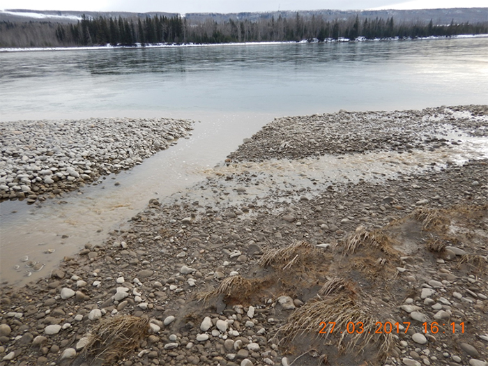
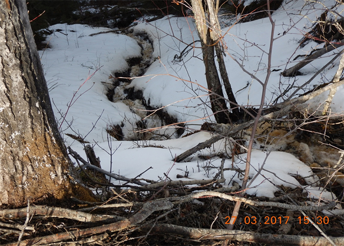
The undersigned observed during the March 24, 2017 to March 28, 2017 inspection that sediment laden contact water from River Road was entering the Unnamed Creek 3 downstream of River Road crossing at STA 72+150 (Figure 1). The undersigned observed the water in Unnamed Creek 3 to be turbid (Figure 2).
In Appendix I of the CEMP - Erosion and Sediment Control Plan, the proponent commits to the following, in order to isolate contact water from local water courses: [2]
"Collect and treat contact water in centralised BMP locations with sufficient capacity to manage the design storm (primarily temporary sediment ponds)."
AND
"Treat and discharge high quality water to a designated water course, infiltration areas or other area with a direct connection to a natural water course."
In regards to the issues identified, the Agency issued a Notice of Intent to Issue an Order on April 5, 2017. The measures presented in the April 21, 2017, representations made by the proponent in response to the Notice of Intent to Issue an Order were insufficient to determine compliance.
In the course of the April 23 and 24, 2017 follow-up inspection, the undersigned also observed the erosion and sediment control measures identified in the representations.
Blind Corner & River Road Remediation Works
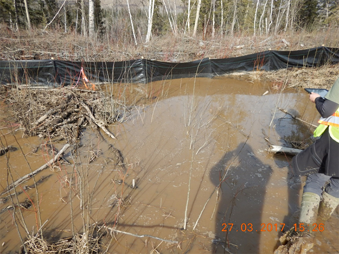
In the course of the inspection conducted between March 24, 2017 and March 28, 2017, the undersigned observed sediment laden water flowing down the ditch adjacent to River Road at the area known as Blind Corner. The undersigned observed that the sediment and erosion control measures in place were ineffective in preventing sediment transport in the ditch adjacent to River Road at Blind Corner within the work area boundary established within the Environmental Protection Plan (EPP) titled "BC Hydro Blind Corner & River Road Remediation Works" (Figure 3).
The aforementioned EPP contains more specific requirements for the work area as required and established by the overarching CEMP (see Annex II for excerpt from EPP). In particular, the EPP states that:
"Priority will be placed on proactively implementing erosion control measures prior to starting work to minimize the need for sediment control. General measures applicable to this project include: … Installing silt fence or other measures between the work area and any watercourse or wetland where there is the potential for sediment to reach it…"
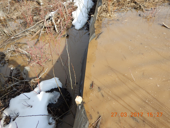
The undersigned witnessed that sediment laden water flowed from the ditch, was directed through a culvert and entered the Peace River (Figure 4 and Figure 5).
In response to the issues identified, the Agency issued a Notice of Intent to Issue an Order on April 5, 2017. The measures presented in the April 21, 2017representations made by the proponent in response to the Notice of Intent to Issue an Order were insufficient to determine compliance.
During the April 23 and 24, 2017 inspection, the undersigned observed the erosion and sediment control measures identified in the representations and observed that sediment laden water was still flowing down the ditch adjacent to River Road at the area known as Blind Corner. The check dams were not constructed as per best management practices and in accordance with the water management, erosion and sediment control plan described below.
the temporary road ends. Water from the temporary stilling basins may then be pumped (BMP 20) to unnamed creek to maintain drainage.
5.8.3 River Road
River Road is located on the left bank of the Peace River and was constructed from gravel materials excavated from the river. The erosion potential of this area is considered to be low. The following ESC controls are suggested:
- The riverside edge of the road is protected with riprap. This edge should be generally maintained at a higher elevation than the rest of the road surface, both during construction and for final grading. Runoff flow from the road surface should be directed to a backslope ditch. Flow in the sloped portion of the ditch should be controlled with rock check dams (BMP 11) at approximately 15 m spacing. Enlarged ditch sections should be provided where topography allows to act as sediment traps (BMP 21). It is considered that water in the sediment trap will seep through the granular road base to the Peace River.
Area A Excavation
In the course of the March 24, 2017 to March 28, 2017 inspection, the undersigned observed sediment laden water flowing in ditches around stockpiles. The undersigned observed that the sediment and erosion control measures in place were ineffective in retaining surface water containing suspended sediments from leaving the Area A work area and at preventing that water from reaching the Peace River as required by the EPP titled "Site C Clean Energy Project Main Civil Works Area A Excavation Environmental Protection Plan" (Figure 6, Figure 7 and Figure 8).
The aforementioned EPP, states that (see Annex III for excerpt from EPP):
"The primary approach to mitigate this concern is to retain all surface water on site within the Area A work area and to allow it to infiltrate into the permeable ground.
- All surface water is to remain within the Area A work boundary."
In the course of the April 23 and 24, 2017 inspection, the undersigned observed the water management measures described in the representations. The undersigned was able to confirm that there was no flow of surface water containing suspended sediments leaving Area A as previously observed during the March 24, 2017 to March 28, 2017 inspection.
Measures to be Taken
Under the authority given to me pursuant to subsection 94(1) of CEAA 2012, I hereby order you to take the following measures:
Unnamed Creek 3, downstream of River Road crossing at STA 72+150
By June 9, 2017:
- In addition to the measures implemented by the proponent between March 29, 2017 and April 24, 2017, to prevent the deposit of sediment-laden slope runoff into Unnamed Creek 3, which is water frequented by fish, the proponent shall:
- implement erosion and sediment control (ESC) measures in ditches leading to Unnamed Creek 3 to prevent turbid road and slope runoff from being deposited into a place from which deposit into Unnamed Creek 3, may result; and
- implement ESC measures referred to at paragraph (a) and direct any turbid road and slope runoff to a catchment area that is not frequented by fish, and collect and treat that runoff so that it is not deleterious to fish.
- Provide, to the undersigned at compliance.conformite@ceaa-acee.gc.ca, photographic evidence of the implementation of the measures described at item 1.
- The proponent must implement the following measures:
- after deposit of runoff resulting from any activity of the designated project, take a sample of water, once every hour for the duration of the deposit, immediately before the point of deposit from ditches into the fish-bearing segment of Unnamed Creek 3 and determine the turbidity of the sample;
- following the step set out in paragraph (a), within 15 metres downstream of the point at which substances from ditches are deposited to the fish-bearing segment of Unnamed Creek 3, take a sample of the water from Unnamed Creek 3, once every hour for the duration of the deposit, and test the sample for turbidity, with each one hourly sample taken no later than 10 minutes from the sample taken in paragraph (a);
- if the result of any turbidity test referred to in paragraph (b) exceeds the water quality objective for turbidity established in the CEMP, stop all physical activities of the designated project which are within the Unnamed Creek 3 catchment area and which generate turbid road and slope runoff until the turbidity levels in that creek have returned to the levels set out in the water quality objective. In the event that there are no physical activities taking place, stop deposits of deleterious substances, including turbid road and slope runoff, into Unnamed Creek 3 until the turbidity levels in that creek have returned to the levels set out in the water quality objective; and
- report, to the undersigned at compliance.conformite@ceaa-acee.gc.ca, the results of any turbidity test referred to in paragraphs (a) and (b), if the water quality objective for turbidity is exceeded, within 5 days of the exceedance. The report shall include the measures taken by the proponent to return the water in Unnamed Creek 3 to levels of turbidity set out in the water quality objectives.
The measures described in item 3 above shall remain in place until:
- A Certified Professional in Erosion and Sediment Control (CPESC) submits a report to the undersigned at compliance.conformite@ceaa-acee.gc.ca asserting that permanent and effective erosion and sediment control measures have been implemented by the proponent and that road runoff is collected and treated by the proponent prior to being discharged in Unnamed Creek 3 or water frequented by fish.
Blind Corner & River Road Remediation Works
By June 9, 2017, the proponent must:
- Implement the Water Management, Erosion and Sediment Control Plan. Namely, by controlling flow in the sloped portion of the ditch with rock check dams at approximately 15 m spacing and by installing sediment traps where topography allows.
- Monitor the efficiency of the ESC measures implemented in the ditch between the culvert of Unnamed Creek 3, 12+420 and STA 12+900, in accordance with the Water Management, Erosion and Sediment Control Plan. If the measures prove ineffective, make alterations until the measures prove effective at preventing sediment transport.
- Provide, to the undersigned at compliance.conformite@ceaa-acee.gc.ca, a statement or statements signed by a CPESC for any new ESC measures implemented. The statement shall:
- identify whether the ESC measures were developed by the CPESC; or that the implementation of the measures was supervised by the CPESC;
- if the source of the ESC measures was a professional body, standard-setting organization or another entity; shall identify the name of that body, standard-setting organization or entity and the title or name of the ESC measures;
- establish whether the implementation of the measures identified in (a) or (b) was carried out by the CPESC; or
- confirm that the CPESC supervised the implementation if the implementation was carried out by the proponent or by others; and
- confirm that the measures implemented were in accordance with the Water Management, Erosion and Sediment Control Plan to which the proponent is subject.
- Provide, to the undersigned at compliance.conformite@ceaa-acee.gc.ca, by June 9, 2017, updates on the implementation schedule for works described in the EPP for the BC Hydro Blind Corner & River Road Remediation Works or, should the proponent extend the works in the implementation schedule beyond June 9, 2017, the proponent must continue to report to the undersigned at the above-named email address every Friday following June 9, 2017, until all the works have been completed.
The measures described in item 1, 2 and 3 above shall remain in place until:
- A CPESC submits, to the undersigned at compliance.conformite@ceaa-acee.gc.ca, a determination of whether permanent erosion and sediment control measures are necessary to prevent the movement of sediment between STA 12+900 and the Unnamed Creek 3 culvert under River Road. This assessment shall be sent by the proponent to the undersigned at compliance.conformite@ceaa-acee.gc.ca; and
- The proponent has completed the installation of a bentonite lining in the ditch that is described in the EPP titled "BC Hydro Blind Corner & River Road Remediation Works" and that is in the between STA 12+570 and STA 12+900.
Work area at Area A
By June 9, 2017:
- Monitor the efficiency of the ESC measures implemented between March 29, 2017 and April 24, 2017 in Area A to prevent surface water from leaving the Area A work area and from entering the Peace River. If the measures prove ineffective at preventing surface water from leaving the Area A work area and from entering the Peace River, make alterations until the measures prove effective.
- In addition to the measures implemented by the proponent between March 29, 2017 and April 24, 2017, the proponent shall:
- Provide, to the undersigned at compliance.conformite@ceaa-acee.gc.ca, a copy of an Environment Protection Plan (EPP) and Care of Water Plan (COWP) for the work area at Area A that have been revised by Peace River Hydro Partners;
- Provide, to the undersigned at compliance.conformite@ceaa-acee.gc.ca, a statement signed by a CPESC if any additional ESC additional measures are implemented following the revision of the EPP and COWP. The statement must certify that the CPESC developed the measures or chose measures already developed by another person that the CPESC supervised the implementation of the measures and that the CPESC confirmed that the measures are implemented in accordance with the Environment Protection Plan (EPP) and Care of Water Plan (COWP) for the work area at Area A and with Best Management Practices; and
- Provide, to the undersigned at compliance.conformite@ceaa-acee.gc.ca, on the 15th day and the 30th day of every calendar month, updates on the implementation schedule of any additional work resulting from the revisions to the EPP for the work area at Area A until all the work set out in the EPP has been completed.
Effective Date of the Order
This Order takes effect immediately on May 25, 2017 at the time of delivery of the order to the proponent. Nothing in this Order shall be construed as reducing, increasing, or otherwise affecting what may be required of the Proponent to comply with all applicable legislative or legal requirements.
Compliance with this Order is Mandatory
Failure to comply with an Order issued under section 94 of CEAA 2012 is an offence under subsection 99(2) of CEAA 2012. The penalty for a first offence is a fine of not more than $200,000, and the penalty for any subsequent offence is a fine of not more than $400,000. If the offence of failure to comply with this Order continues on more than one day, each day that the proponent fails to comply with the Order constitutes a separate offence (subsection 99(4) of CEAA 2012). A court may apply a penalty for each day that the non-compliance with the Order continues.
Review of the Order
Within 30 days from the date of your receipt of the Order, the proponent may request, in writing, a review of the Order by an Agency Official.
The proponent may address its request to:
CEAA Review Officer
Place Bell Canada, 22nd Floor
160 Elgin Street
Ottawa, Ontario
K1A 0H3
A request for a review does not suspend the operation of the Order and compliance is mandatory. Should the proponent want the Order to be suspended while it is being reviewed, that demand must be included in its request. If the proponent is not satisfied with the outcome of the review, the proponent can apply for judicial review of the Order by the Federal Court of Canada (Trial Division).
Should the proponent not wish to seek review of the Order with the Agency, the proponent may directly apply for judicial review of the Order by the Federal Court of Canada (Trial Division).
Should a person seek judicial review of the Order by the Federal Court of Canada (Trial Division), the Order is not automatically suspended. The person must specifically make that request to the Court.
Date of Issuance
This Order is issued on May 25, 2017, by Senior Enforcement Officer Nicolas Courville.
<Original signed by>
Nicolas Courville
Senior Enforcement Officer
Compliance Promotion and Enforcement Unit
Canadian Environmental Assessment Agency
Please note that in accordance with the Compliance and Enforcement Policy for the Canadian Environmental Assessment Act, 2012 and the Canadian Environmental Assessment Agency's policy on transparency, this Order will be posted on the Agency's Compliance Promotion and Enforcement website.
Annex 1 - Figures


Annex II - Excerp from EPP titled "BC Hydro Blind Corner & River Road Remediation Works"
7.3 Noise and Vibration Management
Construction activities will occur away from residences and campgrounds; therefore, disturbance from noise and vibration are not anticipated. It is expected that noise levels for this project will not exceed noise standards as the project site is located far enough from urban settings. To reduce noise impacts for rural residents, the following practices will be implemented:
- Equipment will be maintained in good working order;
- Equipment will be equipped with the appropriate silencers and mufflers, as designed (as per CEMP 4.11)
- Drive-thru pathways will be used for material drop off or pick up whenever possible to reduce the use of back-up beepers; and,
- No unnecessary idling of vehicles.
7.4 Erosion Prevention and Sediment Control Management
A CPESC will Monitor and prescribe field-fit erosion and sediment control measures following BMPs as per Appendix G of the EPP and Appendix I of the CEMP. These will be presented in as and when needed. The CPESC will supervise the implementation of the ESC measures, document the completion of the ESC work plan and any field fit changes to the original work plan if they were required, and conduct ongoing monitoring inspections to verify the effectiveness of the measures and/or the need for additional works.
Priority will be placed on proactively implementing erosion control measures prior to starting work to minimize the need for sediment control. General measures applicable to this project include:
- Minimizing ground disturbance that could expose erodible materials and cover exposed materials as soon as possible with seed and mulch, erosion control blankets/matting or gravel;
- At stream crossings, direct clean water around the area and direct any sediment-laden water away from all watercourses and wetlands;
- Installing silt fence or other measures between the work area and any watercourse or wetland where there is the potential for sediment to reach it;
- Remove any sediment build-up from any sediment and erosion control measure once it reaches one-third to one-half capacity;
- Ensure any rip rap is clean and free of debris before using at any stream crossing;
- Locate stockpiles a minimum of 15 m from any watercourse and/or wetland. Cover stockpiles within 15 m of any watercourse and/or wetland with polysheeting, tarps or similar and surrounded by silt fence; minimize the amount of time that stockpiles are kept on site;
- Prior to applying seed and mulch, roughen soil surface;
- Inspect sediment and erosion control measures a minimum of a weekly basis and after any storm event greater than 12 mm of rainfall in a 24-hour period, a heavy snowmelt or combination of rain on melting snow and on wet or thawing soil;
- Inspect and repair as needed erosion and sediment control measures following an extreme weather event (great than 25 mm in a 24-hour period); and,
- Temporarily delaying work if high precipitation levels could result in erosion.
Contingency supplies of sediment and erosion control materials shall be maintained at each construction site and workers shall be sufficiently trained in their appropriate installation and maintenance. minimum supply of contingency supplies to be kept onsite will include:
- 10 rolls of silt fence;
- 5 rolls of polyethylene sheeting;
- 1 length of turbidity curtain;
- 3 Sediment booms;
- 10 straw wattles;
- 5 bales of certified weed-free straw;
- 5 Bunddles of wooden survey stakes;
- 20 sandbags (empty or filled);
- 1 role of page wire;
- 10 5' lengths of angle iron;
- 5 meter bags; and,
- 2 shovels and a Pulaski.
7.5 Fisheries and Aquatic Habitat Management
There is no instream work planned as part of the current scope of the Blind Corner and River Road Remediation works.
7.6 Groundwater Protection
Works associated with the Blind Corner and River Road Remediation Project are not anticipated to have any impacts to groundwater. Potential sources would be a result of any large spills of hydrocarbons onto the ground. All spills will follow Section 7.9 for response and clean-up procedures.
7.7 Hazardous Waste Material
Hazardous materials such as fuels, oil, grease, lubricants and batteries may be onsite. Hazardous waste spills could affect water quality, air quality, fish and wildlife habitat and workers using the products.
- Store, handle and transport hazardous materials in a manner that avoids loss and allows containment and recovery in the event of a spill, in accordance with all applicable legislation;
- Hazardous materials will be stored in locked storage areas when not in use;
- All hazardous materials and wastes must be stored a minimum 30 m from any wetland, watercourse or environmentally sensitive area;
- Appropriate areas for the transfer and limited temporary storage of hazardous materials and wastes will be designated if required;
- Material Safety Data Sheets (MSDS) will be available on-site for all chemicals and products and employees will be trained in Workplace Hazardous Material Information System (WHIMS);
- Personnel will be adequately trained in the handling and transportation of hazardous materials;
Annex III – Excerpt from EPP titled "Area A Excavation Environmental Protection Plan"
2.2.7 Surface Water Management
The surface water quality/quantity management concept consists of the following elements, which are currently under design/review by the hydrotechnical engineering design team:
- The primary water quality concern associated with the excavation at Area A is the potential for surface water containing suspended sediments to reach the Peace River. The primary approach to mitigate this concern it to retain all surface water on site within the Area A work area and to allow it to infiltrate into the permeable ground.
- All surface water is to remain within the Area A work boundary. No surface water will leave Area A during the excavation activities.
- Excavation depths are expected to vary up to 15 m or more below the existing ground surface Therefore the excavation areas will serve as local collection sumps. Water will be collected in the excavation areas and allowed to infiltrate into the permeable alluvial ground material.
- In sloped excavation surfaces perimeter berms will be maintained at all times to prevent contact surface runoff from escaping the Area A work area.
[1] Golder Associates Ltd. (October 17, 2014). Fish and Fish Habitat Assessments of L3 Creek. Memorandum prepared for BC Hydro, Vancouver BC. Retrieved April 4, 2017. Page 13.
[2] British Columbia Hydro and Power Authority. (July 8, 2016). Appendix I - Erosion and Sediment Control Plan. Retrieved March 28, 2017. Page 11. https://www.sitecproject.com/sites/default/files/CEMP-Appendices-2-20160708.pdf.